


The emergence of agriculture in the UK is complex and poorly understood (Thomas Reference Thomas1999, 222; Gibson Reference Gibson2003, 136; Sheridan 2003, 3–4; Reference Sheridan, Finlayson and Warren2010, 101; Evans Reference Evans2008, 34–8; Spikins Reference Spikins2008, 4–5; Bishop et al. Reference Bishop, Church and Rowley-Conwy2009, 48–9; Cummings Reference Cummings2017, 46) and is a hotly debated subject (eg, Thomas 1996; 1999, 221; 2007; 2008; Reference Thomas, Anderson-Whymark and Thomas2012; Rowley-Conwy Reference Rowley-Conwy2004; Bishop et al. Reference Bishop, Church and Rowley-Conwy2009, 47; Sheridan Reference Sheridan, Finlayson and Warren2010, 89). In Furness, and indeed the wider Cumbrian region, understanding of this important transitional period is hampered by a lack of excavated material and associated scientific analysis (Hodgkinson et al. Reference Hodgkinson, Huckerby, Middleton and Wells2000, 155; Hodgson & Brennand 2006, 32–3; Reference Hodgson, Brennand and Brennand2007, 39). However, recent developer-funded excavations, including investigations at Stainton Quarry near Barrow-in-Furness, are beginning to shed light upon these early farming communities.
This paper presents summary results from a programme of archaeological mitigation (Northern Archaeological Associates (NAA) 2012; 2013a; 2013b; 2015) carried out by Northern Archaeological Associates for Tarmac Ltd between 2012 and 2015 at Stainton Quarry, in Furness, Cumbria (NGR SD 2480 7300; Fig. 1). The full results are presented within an analysis report (NAA 2017) that will be available online on the ADS website.

Fig. 1. Site location
The investigated area comprised a small block of land (c. 0.7 ha) at the centre of the current workings, to the north of Stainton with Adgarley (Fig. 2). The original local topography had been altered dramatically by quarrying but much of this could be reconstructed from early Ordnance Survey data. The site was to the north and east of the brow of a low hill, close to the south-western limit of Bolton Heads limestone outcrop.
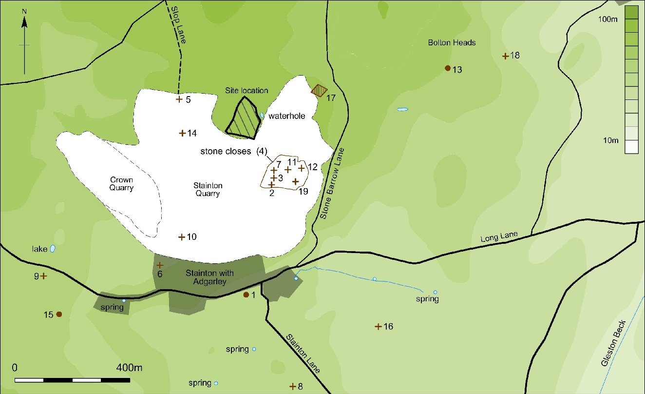
Fig. 2. Excavation area and known archaeological sites and findspots in the vicinity (see Table 1)
Spot heights on the First Edition OS map of 1851 indicate summits to the immediate west and south of the site, as well as another small hill, Castle Haw, to the south-west. Also apparent was a waterhole marked to the immediate north-west of the site. This feature was at the head of a small valley and, hence, could indicate the former presence of a spring (for instance see Wild Reference Wild2003, 26). This valley ran north-eastwards before curving towards the south-east to join a broad valley that ran from Urswick Tarn (Fig. 1) to the coast (hereafter Urswick Valley).
In the wider landscape, the higher ground of Bolton Heads and Little Urswick Crags, which formed the western edge of Urswick Valley, lay to the north-east. The ground sloped more steeply away from the site to the south and especially the south-east. This steeper slope once formed a promontory upon which a stone banked enclosure was recorded in 1912 at Stone Closes (Dobson Reference Dobson1912; Fig. 2). The enclosure would have overlooked an area of the Urswick Valley that broadened out into a largely flat area close to Mere Tarn (Fig. 1).
The site lay upon a north-east to south-west aligned limestone ridge formed by the Urswick and Park Formations (Natural Environment Research Council (NERC) 2017). Approximately 300 m to the south the bedrock geology changes to the calcareous mudstone of the Alston Formation and, after a further 500 m, to the Bowland Shale Formation. At Gleaston village, c. 2.2 km to the south-east of the site, the bedrock changes again to the St Bees Sandstone Formation, which then extends to the coast.
Although no drift geology is recorded within the excavated area (NERC 2017), the investigations revealed glacial till, as well as three areas of outcropping limestone. Soils on the site were of the Crwbin Association; shallow well-drained loams, often associated with limestone pavement (Soil Survey of England & Wales 1983; Jarvis et al. Reference Jarvis, Bendelow, Bradley, Carroll, Furness, Kilgour and King1984).
The Furness Peninsula is an important area with respect to the study of the early prehistory of not only Cumbria but also the wider northern Irish Sea ‘fringe’ (see Bradley et al. Reference Bradley, Rogers, Sturt and Watson2016, fig. 16). Much that is known about the area is due to antiquarian interest, including the work of the Barrow Naturalists Field Club (Evans Reference Evans2008, 120), as well as numerous findspots of prehistoric artefacts (Evans Reference Evans2008, fig. 9.16). More recent discoveries include an investigation of a Neolithic long cairn at Skelmore Heads (Powell Reference Powell1963), fieldwalking of a significant proportion of the lowland areas (Evans Reference Evans2008, fig. 9.2), and small numbers of Neolithic features discovered during modern developer-funded interventions at Breast Mill Beck Road (NAA 2019), Roose Quarry (Jones Reference Jones2001; Oxford Archaeology North (OAN) 2014), and Holbeck Park Avenue (OAN 2002; Evans Reference Evans2018). Of special note is a succession of collections of material from a prehistoric site at North End, Walney Island (Cross 1938; 1939; 1942; 1946; 1947; 1949; Reference Cross1950; Barnes Reference Barnes1955; Evans Reference Evans2008, 120; Greenlane Archaeology 2015).
The importance of North End was emphasised by Bradley et al. (Reference Bradley, Rogers, Sturt and Watson2016, 143, fig. 11) when they theorised that the recovered concentrations of finds were associated with a possible ‘maritime haven’. They suggested that it may represent a prehistoric ‘beach market’, one of several that fringed the coasts of north-eastern Ireland, south-western Scotland, and Cumbria (ibid., 126, 152, fig. 16). These sites may have facilitated the exchange and spread of artefacts, such as Group IV polished axes, Arran pitchstone, and potentially porcellanite axes, around the Irish Sea fringe (ibid., 152).
The number of finds of polished and rough-out axes from the Furness Peninsula as a whole, along with polissoirs and grinding stones from Roose Cote near the coast and Stone Closes (Fig. 2; Table 1), has raised the possibility that axe polishing was undertaken in this region during the Neolithic (Manby Reference Manby1965, 4).
Table 1: heritage sites within 1 km of the site
Excavation results
Soil removal exposed three areas of limestone bedrock (Fig. 3), c. 80 natural features, two pits (7 & 61), and a single post-hole (18). After the discovery of artefacts within eroded channels and grykes associated with bedrock outcrop 20 (see below), all such features were hand-excavated in this area. A sample of the other areas of bedrock were also investigated but these proved to be sterile.
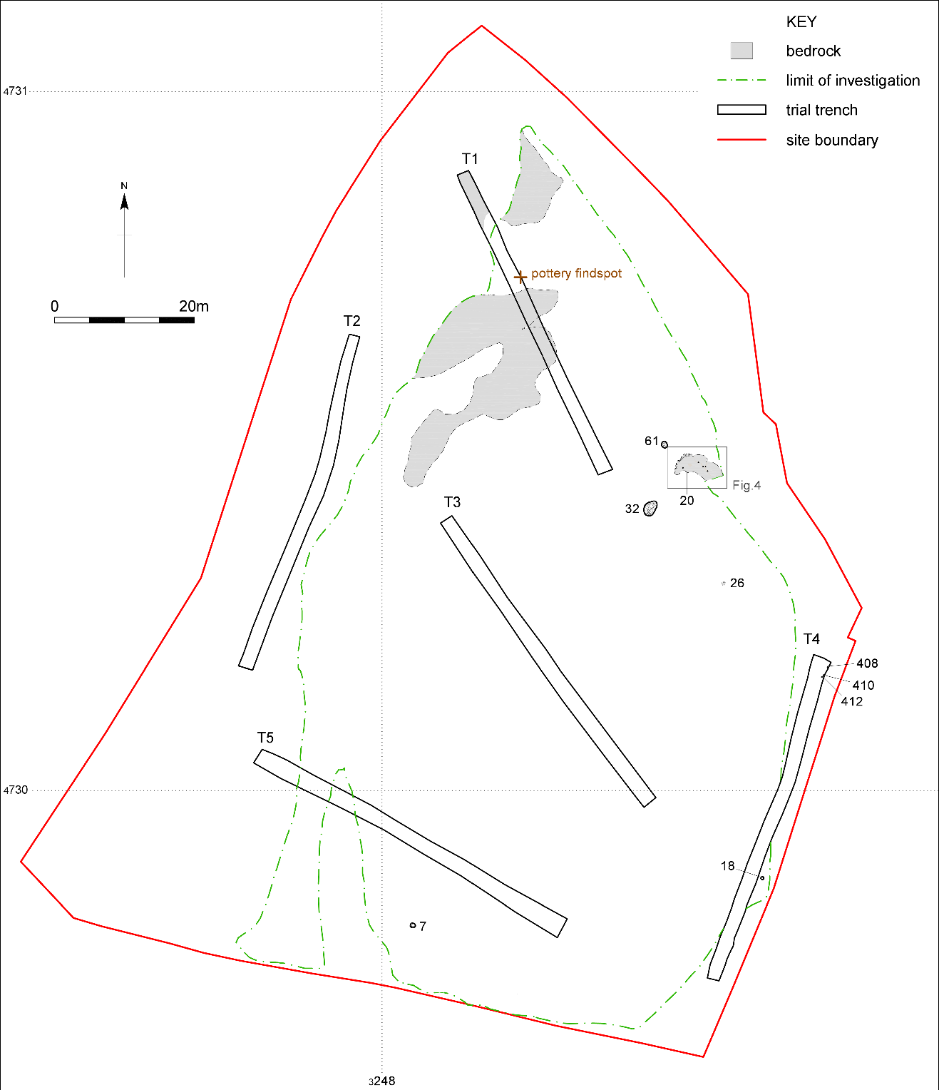
Fig. 3. Excavated remains and bedrock outcrops
The recorded remains were placed into five broad chronological phases. The first three are presented here and comprised a Late Mesolithic charred hazelnut shell, and Early Neolithic and Chalcolithic deposits and artefacts. It should be noted that the terms Mesolithic and Neolithic have been used as chronological indicators within this paper and are not meant in any way to infer strategies of subsistence.
Phase I: Late Mesolithic
The area of outcropping limestone (20) (Fig. 3) seemed to be a focus of deposition (see below). A charred hazelnut fragment from the lower fill (40) of a sinkhole within this outcrop returned an unmodelled date range of c. 4580–4450 cal bc (2σ; SUERC 68520; 5679±27 bp; see Table 9). This material was, however, probably residual from earlier activity suggesting a Late Mesolithic presence in the vicinity.
Phase II: Early Neolithic
Bedrock outcrop 20
A wide range of Early Neolithic artefacts were recovered from deposits within numerous natural erosion gullies etched into the sloping surfaces of outcrop 20 (Figs 4 & 5), a vertical solution feature (21), and two deeper crevices (Grykes A & B) to the north and east. None of these features showed any sign of being intentionally cut or altered. A general sequence of silty deposits devoid of artefacts existed in most of these features; however, a small pitchstone core was recovered from a shallow gully. Furthermore, 11 sherds of Early Neolithic pottery from sherd group (SG) 4 were recovered from an area of turf removed from the outcrop during cleaning. A deep solution feature (21) to the south-west (Fig. 5) produced six Early Neolithic Carinated Bowl sherds and small amounts of charcoal.
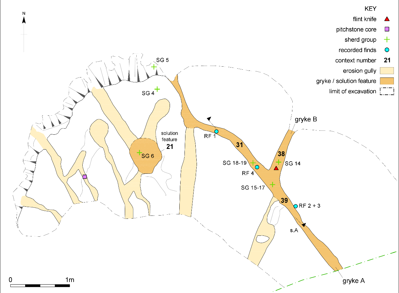
Fig. 4. Distribution of finds recovered from bedrock outcrop 20

Fig. 5. Solution feature 21
To the north-east, during machine removal of topsoil, two large blocks of limestone were disturbed, exposing preserved sequences of deposits within Grykes A and B (Figs 4 and 6). Some of these deposits (31, 38, 39, 40, and 48) were rich in charcoal and contained Early Neolithic artefacts (Fig. 7; Table 2). Finds were also recovered during the removal of loose soil (30) around this area.

Fig. 6. Sequence of surviving deposits within the grykes
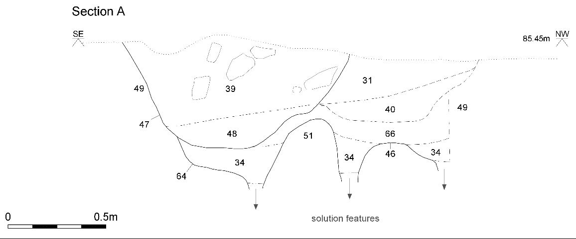
Fig. 7. Section through deposits in Gryke A
Table 2: artefacts and ecofacts from the gryke deposits
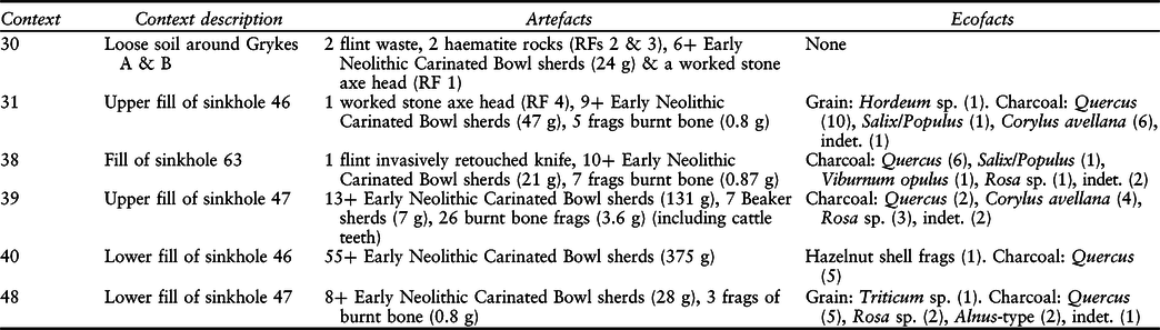
A complex sequence of erosion, natural infilling, and soil-loss had occurred as a result of three small, vertical solution holes in the base of Gryke A and an extensive horizontal crack extending southwards ‘behind’ the deposits shown in Figure 7. A vertical void between the rock and the upstanding deposits indicated that this process of soil loss was potentially still ongoing. In summary, two voids (or small sinkholes; 46 & 47) had formed through natural processes. The lower fills (34 & 66) of sinkhole 46 were pale and devoid of finds, whereas the upper fills (40 & 31) and the fills of sinkhole 47 (48 & 39) represented mixed deposits of redeposited natural sand and charcoal-rich sandy soils. These darker deposits also contained stones, some of which had been burnt, charcoal, charred hazelnut shell and grain, fragments of burnt bone, Early Neolithic pottery, a broken fragment of a polished stone axe (RF 4), and a worked flint.
These finds, and especially the sherds of pottery, were not ‘placed’ within the deposits but followed the same tip lines apparent in several stones, as if they had slumped into the feature. Alternatively, successive soil loss through the solution features could have caused the sherds and stones to slump after they had been deposited.
In order to help understand the formation processes at work within these deposits, the location of each sherd group, lithic, and haematite lump was plotted in plan (see Fig. 4). This clearly demonstrated that the artefacts recovered did not form a single cohesive ‘placed’ cache. Conversely, although most of the pottery groups were found close to the point where Gryke A intersected Gryke B, much of the other material was relatively dispersed. Importantly, the pitchstone core was potentially a background find within the general silting up of the solution features, whereas almost all the pottery was located over solution features.
Sherds from deposits 31, 39, and 40 produced evidence for the processing of dairy fats. The sherd from deposit 31 also produced a series of long-chain fatty acids that may have derived from a plant residue, or possibly from beeswax, although no wax esters were identified. Radiocarbon dating of material from deposits 40, 31, 48, and 39 broadly matched the associated pottery types, except for the fragment of hazelnut shell from context 40 (see above). Interestingly, Bayesian analysis of these dates suggested that deposition within the grykes was a slow process, probably spanning between 2050 and 5750 years (probability of 95.4%).
Tree-throw 32
To the south-west of outcrop 20 (Fig. 3), the upper fills of a tree-throw (32) were similarly rich in artefacts and ecofacts (Fig. 8; Table 3), including part of a charred oak plank or post (sample 41 AA). This feature was formed by the partial uprooting of a tree that fell north-eastwards. The hole left by this was initially infilled through natural processes (deposits 52 & 41); the upper fills (35 & 33), however, were darker and contained charcoal, charred hazelnut shell, and Early Neolithic artefacts. Three sherds from context 35 and one from deposit 41 contained dairy lipids. Bayesian analysis of the three Early Neolithic radiocarbon dates obtained from this feature indicated that the fills within this feature had been deposited fairly rapidly. Additionally, the dates did not provide a good match to the stratigraphical sequence suggesting mixing prior to deposition.
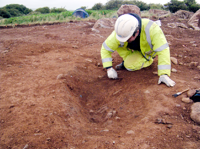
Fig. 8. Excavating tree-throw 32
Table 3: artefacts and ecofacts from tree-throw 32
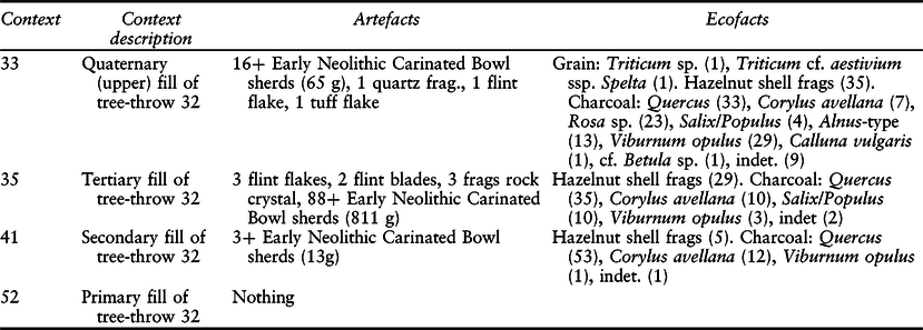
Interestingly, most of the pottery from deposits 33, 35, and 41 was recovered from the south-western area of the feature. These, however, had not been ‘placed’ in the deposit as, similar to the artefacts recovered from the grykes, they followed the tip lines apparent in the alignments of nearby stones. It is most likely that deposits 35 and 33 and the upper portion of 41 represented soil and domestic refuse that had either been backfilled or had slumped into the hollow left after the tree-throw had partially filled up through natural processes.
Pit 7
Approximately 70 m to the south-west, close to the southern limit of the investigation, a single pit was recorded amongst a cluster of root-holes (Fig. 3). This pit contained moderate amounts of charcoal and 60 charred grains, but no artefacts.
Two grains were submitted for radiocarbon dating. These were modelled to c. 3640–3380 cal bc (2σ; SUERC 68510; 4759±29 bp) and 3780–3650 cal bc (2σ; SUERC 68511; 4934±29 bp), suggesting this pit may have been slightly later than the other Neolithic contexts. During Bayesian modelling (see below), a chi-squared test indicated that these two grains could not have ‘died’ in the same year. This was likely the result of a mix of material being incorporated during infilling, possibly from an above-ground accumulation of waste, such as a midden.
Features 408, 410, & 412
During the evaluation phase of groundworks, a cluster of three small features (408, 410, & 412) were recorded at the northern end of Trench 4. Two of these (408 & 410) extended beyond the eastern edge of the trench and may have been truncated pits or post-holes. The third (412) was potentially a small post- or stake-hole. Pit 410 contained seven fragments of Early Neolithic pottery, 52 fragments of charred hazelnut shell, and seven carbonised cereal grains (three wheat and two barley).
These features lay in the base of a hollow (414) visible in the trench edge (NAA 2017, fig. 6). It was unclear whether this was naturally formed or represented part of a structure around a hollow, similar to examples recorded on Early Neolithic settlements in England (Darvill Reference Darvill1996, fig. 6.5), Scotland (Barclay Reference Barclay2003, fig. 8.5; Murray & Murray Reference Murray and Murray2014), and Ireland (Grogan Reference Grogan1996, fig. 4.4).
Phase III: Chalcolithic
The Beaker sherds recovered from the upper deposit (39) within Gryke A were suggestive of Chalcolithic activity in the vicinity (Needham et al. Reference Needham, Parker Pearson, Tyler, Richards and Jay2010, table 1). A fragment of hazel charcoal from this deposit provided a supporting modelled date range of 2470–2290 cal bc (2σ; SUERC 68519; 3888±29 bp). One of the beaker sherds was shown to contained lipids, but the presence of contaminants or low abundances of unidentified lipids meant that it was not deemed appropriate to attempt identification.
Undated features
Two further features (pit 61 & post-hole 18), potentially of an early prehistoric date, were also recorded. Neither produced datable artefacts or suitable material for radiocarbon dating.
The finds
Flint (Hannah Russ)
In total, 15 lithics (Table 4; Fig. 9, 1–5) were recovered during the excavations, including flint, quartz, and pitchstone. Identified tool forms suggested a Neolithic date, possibly the earlier part of this period. Dating of elements of this assemblage was confirmed and refined by radiocarbon assay. The full details of this analysis are presented in NAA 2017 (appx B).
Table 4: flint data
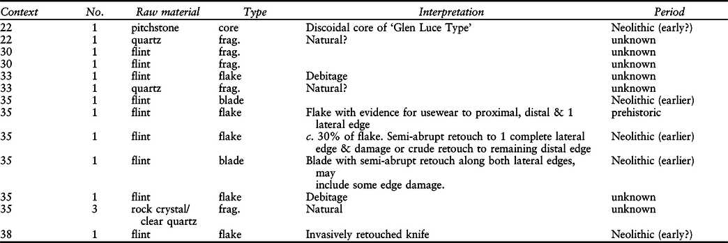
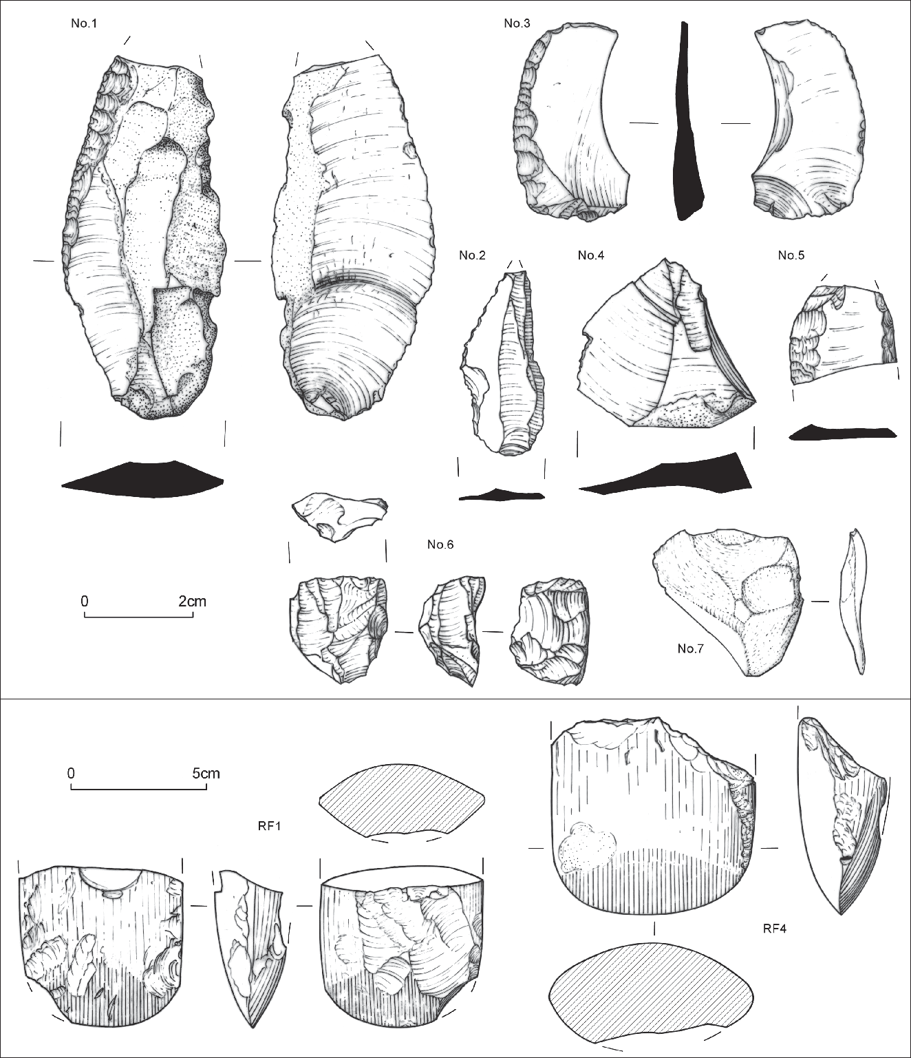
Fig. 9. Lithics
The assemblage was small when compared to potential contemporary collections from the Gleaston area c. 2.4 km to the south-east (Hodgkinson et al. Reference Hodgkinson, Huckerby, Middleton and Wells2000, 35; Evans Reference Evans2008, 124–5). The excavated contexts were, however, probably on the periphery of a focus of activity (see above) and, hence, may only represent part of a larger assemblage. Interestingly, the material comprised both tools and waste flakes, two of which were from the primary stages of flint working (one was burnt).
Pitchstone (Torben Bjarke Ballin)
A small lithic object (Fig. 9, no. 6) was sent for specialist analysis (NAA 2017, appx C). Following inspection, it was possible to determine without doubt that the raw material of the object is Arran pitchstone. The present piece contains neither phenocrysts nor spherulites and the raw material is clearly aphyric pitchstone. It does, however, contain numerous small specks, most probably crystallites, which gives it a slightly spotted appearance. It has no original outer surface and, in terms of reduction sequence, is a tertiary piece.
Aphyric pitchstone is usually associated with the eastern parts of Arran, such as the Corriegills district, the Fairy Glen immediately to the west, and the Monamore Glen further south along the island’s east coast (Ballin & Faithfull Reference Ballin and Faithfull2009, chap. 5). However, aphyric bands may also be found in outcrops of porphyritic pitchstone, such as some of the dykes at Tormore on Arran’s west coast. On balance, the raw material for this piece was probably procured from eastern Arran.
In terms of artefact type, the piece is a small core that belongs to a type which is particularly common amongst Scottish pitchstone assemblages and rare or absent in assemblages based on most other forms of lithic material. Similar cores were particularly common in the large combined assemblage collected from sites in the Glen Luce area, Dumfries & Galloway, and the analyst therefore suggested reference to these pieces as discoidal cores of ‘Glen Luce Type’ (Ballin Reference Ballin2009, fig. 9).
Pitchstone was used on Arran throughout prehistory but the composition of assemblages recovered from sites off the island generally suggest that the extensive exchange network responsible for the distribution of Arran pitchstone across northern Britain – from Orkney in the north to the Isle of Man and Dublin in the south – was a post-Mesolithic phenomenon.
Although archaeological pitchstone has been found at various locations in Cumbria (A. Dickson & F. Brown, P. Cherry, A. Hamilton-Gibney pers. comms), Stainton Quarry may presently be the most southerly location on the British mainland from which archaeological pitchstone has been retrieved. Given the distances across which this raw material was traded towards the north (Orkney), it is highly likely that it was also traded into Lancashire and Yorkshire, if not further towards the south (Ballin Reference Ballin2008).
Stone axes and haematite (Ann Clarke)
Two axe fragments (Fig. 9, RFs 1 & 4) were found, both of which were blade ends. The full details of the analysis of these items are presented NAA Reference Cummings2017 (appx D). One is fine-grained grey/green Langdale tuff (RF 1), whilst the other is a blue/grey fine- to medium-grained rock with occasional large angular inclusions (RF 4). Both were flaked, ground, and polished all over to produce a sharp, undamaged curved blade end. Little survives of the rest of these axes to determine the original morphology; the sides are thin and rounded, except for one narrow flat facet worn down one side of RF 1. There has possibly been some reshaping of the blade of RF 4 after its original use because there is some pecking, a regrinding facet, and an asymmetrical curve to the blade outline, suggesting careful reworking.
After this careful shaping and, in the case of RF 4, reshaping, both axes were deliberately broken by a blow to the centre of one face. On RF 1 this broken edge was subsequently used as a platform from which several large flakes were detached to remove much of one polished face.
A flake of Langdale tuff (Fig. 9, 7), of very similar material to RF 1, was found in the upper fill of tree-throw 32. This inner broad flake has a narrow, flat platform and multi-directional flake scars on the dorsal face. There was no sign of a remnant polished surface to indicate that it had been detached from a ground stone axe. However, given the deliberate intention to break the stone axes and then detach further flakes from the blade fragments it is likely that this inner flake was part of a larger ground stone axe that had been subjected to further and considerable fragmentation by flaking.
Two lumps of grey/silver haematite (RFs 2 & 3, not illus.) were recovered during post-machining cleaning (30). Neither appears to have been modified in any way, for instance, by rubbing or deliberate fragmentation. The purpose, if any, of this material in these contexts is not known. Haematite is formed naturally in limestone deposits and was mined in the immediate area, so these items may have been incidental discoveries.
Although there are hundreds of Langdale axes found across the British Isles, from Orkney to Cornwall, the great majority are not associated with their original context of use, having been collected as stray finds. Consequently, both the means by which the axes were moved around the landscape and the life-cycles of these stone objects are not fully understood beyond their initial production at the stone quarries themselves. Finds of axes in both roughout form and finished examples are a feature of the Furness Peninsula, where their current distribution is concentrated at its southern end. This may indicate that this was one of the areas to which axe blanks were brought from the quarries of Great Langdale to be finished by grinding and polishing (Manby Reference Manby1965; Bradley & Edmonds Reference Bradley and Edmonds1993, figs 7.4 & 7.5). Currently, there is no conclusive dating for this activity except for the observation that, in the later phases of quarrying, axes were more carefully shaped by flaking, leaving just the grinding and polishing to be carried out in the lowlands (Bradley & Edmonds Reference Bradley and Edmonds1993, 142–4). Polissoirs and axes were found during excavation at Ehenside Tarn on the south-western Cumbrian coast (Hodgson & Brennand Reference Hodgson, Brennand and Brennand2006, 33–4) and, more recently, at Stainton West, Carlisle. At the latter site, a polissoir was found in a pit dated to 3630–3360 cal bc (OAN 2015). The axes from Stainton Quarry were from a later stage of use, as not only had they been ground and polished but they had also then been deliberately broken prior to deposition.
The 2015 excavation at Stainton Quarry lies in an area immediate to the location of earlier finds of stone axes; Dobson (Reference Dobson1912) mentions approximately 12 stone axes found in the area of the quarry at the turn of the century. He observed that several were found either in limestone crevices or in weathered hollows and that most were polished and some broken (Dobson Reference Dobson1912, 281). This suggests that the occupation of this area was more extensive than that indicated by the present excavation. In addition, it appears that either the natural hollows and crevices were deliberately selected for deposition or occupation debris found its way into these by natural agency or via human clearance of the area.
Prehistoric pottery (Alex Gibson)
Some 1.65 kg of prehistoric pottery was recovered during the Stainton Quarry investigations; the full details of the analysis of this material are presented in NAA 2017 (appx E). The assemblage comprises two distinct and widely separated chronological elements: Early Neolithic and Early Bronze Age. The former is represented by a comparatively large and rare assemblage in this area and is of considerable importance in the western distribution of the Carinated Bowl. The Early Bronze Age is represented by small sherds of undoubted Beaker affinity with characteristic fabric and decoration. Unfortunately, too little survives to allow much discussion of this material.
Four fabrics were identified and can be described as follows:
-
Fabric 1: Grey–black fabric with abundant angular quartzite inclusions <5 mm across. Some inclusions break both surfaces but especially the outer which often appears more abraded. The fabric is hard and well-fired, and some smooth surfaces are visible, especially on sherds from the upper part of the vessels.
-
Fabric 2: Soft brown fabric with abundant quartz and grog inclusions <5 mm across. The grog gives the sherds a slightly smooth and ‘soapy’ texture. Despite this, the fabric is still well-fired.
-
Fabric 3: Fabric similar to Fabric 1 but containing far fewer quartzite inclusions and some voids resulting from the burning out of organic inclusions. The fabric has a soft, slightly soapy texture but is nevertheless well-fired.
-
Fabric 4: Thin, fine, soft brown fabric with finely crushed grog inclusions and a darker core.
The term ‘sherd group’ (SG) is used here instead of ‘individual vessel,’ especially in cases where there are few conjoining sherds. The lack of refitting adds a degree of subjectivity to the attribution of sherds to specific pots using criteria such as fabric, colouration, abrasion, and surface finish. These criteria are incredibly variable in hand-built and open fired (Neolithic & Bronze Age) pottery; sherds can have a mottled colour due to firing or post-depositional conditions, and thickness and the degree of abrasion can vary within individual vessels, as can rim forms. ‘Sherd group,’ therefore, is more objective and acknowledges that similar sherds may or may not be from the same vessel. It does, however, suggest a minimum number of individual pots, while acknowledging that the actual number may be much greater.
The SGs all represent hand-built, open-fired vessels (Fig. 10). The blotchy surface colouration of many sherds, varying from black through grey to brown or brown/pink, is typical of open-fired pottery where the firing conditions (smoky, variable oxygen) cannot be properly controlled. The dark cores, caused by the incomplete combustion of naturally occurring organic material, are also indicative of short (and therefore economical) firing times. Join voids can be detected (SG1 & SG4) indicating coil, ring, or strap construction (it is impossible to differentiate between the three techniques in small sherd material).
Fig. 10. Pottery
Evidence for secondary forming techniques is not really visible due to the fragmentary and abraded nature of much of the assemblage but smoothing and finishing facets can be detected (SG8, 10, & 11). In particular, those from or near the rim appear to indicate smoothing or wiping with a soft material such as a cloth or soft leather. The flattening facets on some rims (SG11) may have been formed using a more robust item made from, for example, wood.
Rim sherds were noted in SG8, 9, 10, 11, 12, 13, 15, and 19. The rims are generally well formed and rounded in profile. The rims have either an upright (SG11, 12, & 15) or everted (SG10, 13, & 19) profile. The rim of SG10 is slightly thickened externally, whilst that of SG13 is slightly thinned, producing a slightly pointed profile. Rim diameters are difficult to estimate given the small sherd size and the variability of curvature often noted on prehistoric pottery, but SG10 may possibly have had a diameter of 16–18 cm, SG11 c. 22 cm, and SG19 c. 20 cm. This suggests moderately sized bowls, though the thickness of some wall sherds hints at a larger element in the assemblage.
Shoulder sherds are identifiable in SG1, 4, and 19. These suggest strongly angled shoulders in the case of SG1 and 4 whilst, in the case of SG19, the profile is much more rounded, suggesting a ‘baggy’ profile not dissimilar to SG12. Simple rounded bowls are difficult to identify with certainty, but SG11 and 15 may represent such vessels. Hollow or concave neck sherds are also recognisable in the assemblage (SG2 & 10) and further confirm the presence of everted rim bowls.
SG17 differs markedly from the rest of the assemblage in terms of the fabric, colour, and texture of the sherds. They are all small body sherds with no rim or base fragments present but the thinness of the sherds and the toothed comb decoration clearly identifies them as Beaker. Too little survives for the decorative scheme to be identifiable but the presence of oblique lines may possibly suggest filled chevron motifs.
Some 20 sherd groups can be identified from 13 different contexts. The majority of these (18) are in Fabric 1 and represent Early Neolithic Carinated Bowls. The fabric and finish of these vessels are entirely in keeping with this tradition, which tend to be well-made and well-formed. Some shoulder sherds (SG1 & SG4) suggest sharply carinated vessels, whilst others (SG3 & SG10) suggest more slack shoulders or indeed rounded bowls, both of which variants are found in Carinated Bowl assemblages in northern Britain (Sheridan Reference Sheridan, Whittle and Cummings2007). As such, these can be dated from the 39th–38th centuries cal bc, lasting into the 36th (Sheridan Reference Sheridan, Whittle and Cummings2007; Whittle et al. Reference Whittle, Healy and Bayliss2011) and represent the first ceramic type in Britain at the start of the Neolithic.
The Early Neolithic pottery from north-west England has been reviewed by Manby (Reference Manby2007) and the sizes, rim profiles, and fabric of the present assemblage bear comparison with those from Ehenside Tarn (ibid., fig. 4.2). The corpus of such material in Cumbria is small and the present assemblage may well be the largest recovered to date. Carinated Bowls are also rare in the Pennines to the east that separate Cumbria from the larger Carinated Bowl assemblages of eastern Yorkshire (Manby et al. Reference Manby, King, Vyner, Manby, Moorhouse and Ottaway2003). The chance find of two Neolithic pits at the hillfort at Portfield, however, is an obvious exception (Beswick & Coombs Reference Beswick, Coombs, Manby and Turnbull1986). Here, two oval pits produced fragments of six vessels represented mainly by rims of forms comparable to the present assemblage. One strongly everted and slack profiled bowl (P1) may bear comparison to some of the material from Stainton Quarry, particularly SG19. A rounded, strongly everted rim-sherd from Low Plains, Cumbria, has been burnished with the horizontal burnishing facets still visible and is almost certainly from a well-made Carinated Bowl. The sherd comes from a fairly large vessel and, though it is difficult to estimate the size accurately, the rim is unlikely to have had a diameter of less than 24 cm (Gibson Reference Gibson2015).
The Beaker represented by SG17 is clearly a much later element of the assemblage attesting to activity in the Chalcolithic or earlier Bronze Age. One sherd in the grog-filled Fabric 2 differs from the other material and may possibly be from a later vessel, perhaps Collared Urn of the Bronze Age, dating to c. 2000–1500 cal bc. However, it is unwise to date earlier prehistoric pottery by fabric alone. In the absence of diagnostic decorative or formal traits, this vessel may still be part of the Carinated Bowl assemblage, as so little is known about the fabric variation of this period in this region.
Palaeobotanical and charcoal analysis (Lynne F. Gardiner)
Charcoal (Table 5) and palaeobotanical remains (Table 6) from selected contexts were analysed (NAA 2017, appx F) in accordance with Campbell et al. (Reference Campbell, Moffett and Straker2011) and English Heritage (2008).
Table 5: charcoal data (no. frags)
Table 6 charred plant remains (no.)
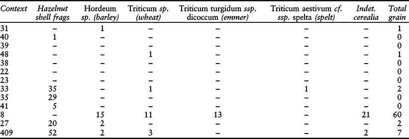
The largest grain assemblage originated from pit 7 and comprised barley and emmer. The presence of these cereals and their relative proportions (ie more barley than emmer) is comparable to evidence detailed by Bishop et al. (Reference Bishop, Church and Rowley-Conwy2009, 77) in their review of Neolithic sites in Scotland. A lack of other cereal plant parts (ie chaff and rachis), as recorded at Stainton, can be indicative of crops being processed away from their point of final deposition. However, many factors affect their survivability in the archaeological record (Bishop et al. Reference Bishop, Church and Rowley-Conwy2009, 82).
Overall, the most abundant wood taxon observed in the charcoal was oak. However, this was probably artificially high due to the ease at which oak charcoal fractures into small pieces. The taxa identified collectively suggest open woodland. This supports Evans (Reference Evans2008, 19) who dismissed previous palynological-based antiquarian views of a closed canopy forest throughout Cumbria during the period c. 5500–3200 bc and further highlights, along with the Holbeck Park Avenue material (OAN 2002; Evans Reference Evans2018), the potential for the recovery of significant palaeoenvironmental material in Furness and Cumbria as a whole.
Calcinated bone (Lynne F. Gardiner)
A total of 41 small fragments (6.07 g) of calcined bone was recovered (Table 7) but include possible human bones (M. Holst, pers. comm.) and two fragments of lingual infoldings of cattle (Bos sp.) teeth.
table 7: bone data (all calcined bone)
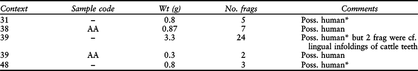
* Malin Holst pers. comm.
Scientific analysis
Organic residue analysis (Julie Dunne & Richard P. Evershed)
A total of 17 sherds from separate sherd groups were submitted for analysis. One of these (STQ017) was sub-sampled due to the presence of two different lipid signatures. The full details of this analysis are presented in NAA 2017 (appx G).
Lipid analysis and interpretations were performed using established protocols described in detail elsewhere (eg, Dudd & Evershed Reference Dudd and Evershed1998; Correa-Ascencio & Evershed Reference Correa-Ascencio and Evershed2014). The lipid recovery rate was 59%, which compares favourably to those extracted from British Neolithic sites (43%: Copley et al. Reference Copley, Berstan, Dudd, Aillaud, Mukherjee, Straker, Payne and Evershed2005a). The mean lipid concentration from the sherds (Table 8) was 2521.7 µg g-1 (2.52 mg g-1), with a maximum of 17456.4 µg g-1 (17.46 mg g-1). Several potsherds contained very high levels of lipids (eg, STQ004, 17.4 mg g-1, and STQ012, 15.9 mg g-1), demonstrating excellent preservation. For example, the maximum concentration of absorbed lipid observed in an archaeological potsherd to date is 17.8 mg g-1 (Copley et al. Reference Copley, Bland, Rose, Horton and Evershed2005c). This likely indicates that these were vessels that underwent sustained use.
Table 8 lipid data
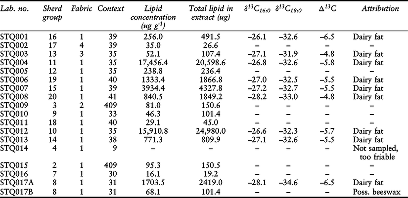
Gas chromatography (GC) and gas chromatography and mass spectrometry (GC-MS) analysis of the total lipid extracts (TLEs; n=18) showed that all the samples contained sufficient concentrations (>5 µg g-1) of lipids that can be reliably interpreted (Evershed Reference Evershed2008). However, some of these lipid profiles contained either contaminants or low abundances of unidentified lipids and these were not taken forward for analysis. The remainder comprised lipid profiles that demonstrated that the free fatty acids, palmitic (C16) and stearic (C18), typical of a degraded animal fat (Fig. 11) were the most abundant components (eg, Evershed et al. Reference Evershed, Mottram, Dudd, Charters, Stott, Lawrence, Gibson, Conner, Blinkhorn and Reeves1997; Berstan et al. Reference Berstan, Stott, Minnitt, Ramsey, Hedges and Evershed2008).
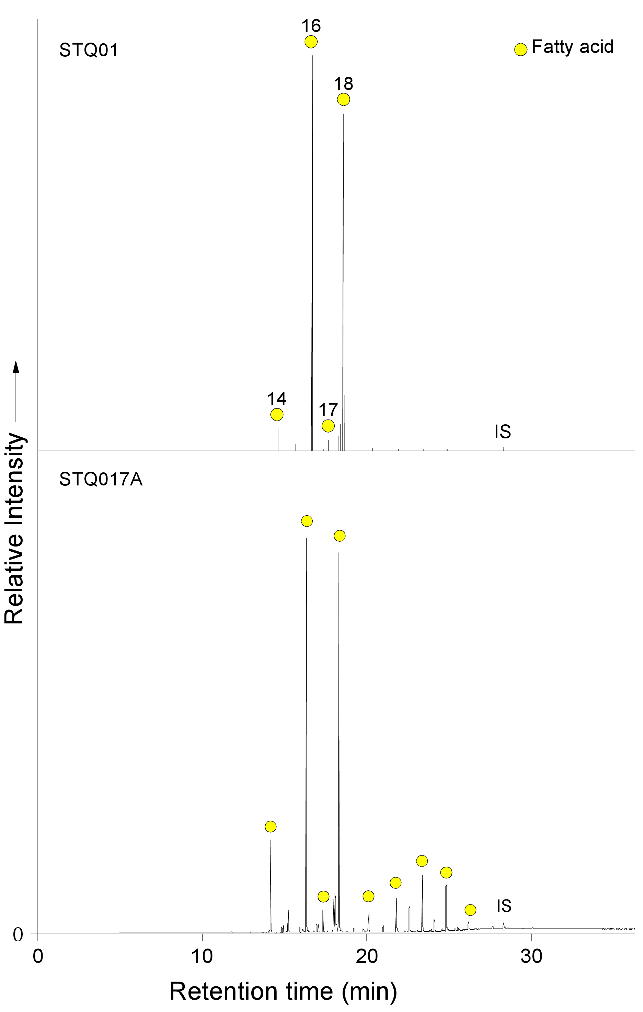
Fig. 11. Gas chromatograms of trimethylsilylated FAME from pottery extracts STQ001 and STQ017A, circles = n-alkanoic acids (fatty acids, FA); IS, internal standard, C34n-tetratriacontane
Samples STQ003, STQ004, STQ006, STQ007, STQ008, STQ012, STQ013, and STQ017A also include a series of long-chain fatty acids (in low abundance), containing C20 to C28 acyl carbon atoms. It is thought these LCFAs probably originate directly from animal fats, incorporated via routing from the ruminant animal’s plant diet (Halmemies-Beauchet-Filleau et al. 2013; Reference Halmemies-Beauchet-Filleau, Vanhatalo, Toivonen, Heikkilä, Lee and Shingfield2014). However, sample STQ017B, which also comprised a series of long chain fatty acids, also included a series of long-chain n-alkanes, although no long-chain n-alkanols were identified. This may have a plant origin or possibly originate from beeswax, although no wax esters were identified.
Gas chromatography-combustion-isotope ratio mass spectrometry (GC-C-IRMS) analyses were carried out on samples STQ001, STQ003, STQ004, STQ006, STQ007, STQ008, STQ012, STQ013, and STQ017A to determine the δ13C values of the major fatty acids, C16:0 and C18:0, and ascertain the source of the lipids extracted through the use of the Δ13C proxy (Table 8). These all originate from fabric type 1 but there does not seem to be any further relationship between the lipid residues and sherd groups.
The δ13C values of the C16:0 and C18:0 fatty acids are plotted onto a scatter plot along with the reference animal fat ellipses (Fig. 12). It has been established that when the extract from a vessel plots directly within a reference ellipse, for example, ruminant dairy, ruminant adipose, or non-ruminant adipose, then it can be attributed to that particular classification. If it plots just outside, then it can be described as predominantly of that particular origin. However, it should be noted that extracts commonly plot between reference animal fat ellipses and along the theoretical mixing curves, suggesting either the mixing of animal fats contemporaneously or during the lifetime of use of the vessel (Mukherjee Reference Mukherjee2004; Mukherjee et al. Reference Mukherjee, Copley, Berstan, Clark, Evershed, Mulville and Outram2005).
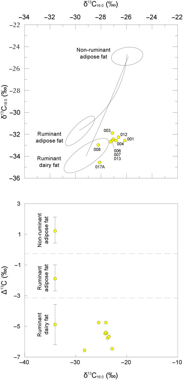
Fig. 12. Graphs showing: a) δ13C values for the C16:0 and C18:0 fatty acids for archaeological fats extracted from Stainton Quarry ceramics. The three fields correspond to the P = 0.684 confidence ellipses for animals raised on a strict C3 diet in Britain (Copley et al. Reference Copley, Berstan, Dudd, Docherty, Mukherjee, Straker, Payne and Evershed2003). Each data point represents an individual vessel; b) the Δ13C (δ13C18:0–δ13C16:0) values from the same potsherds. The ranges shown here represent the mean ±1 s.d. of the Δ13C values for a global database comprising modern reference animal fats from Africa (Dunne et al. Reference Dunne, Evershed, Salque, Cramp, Bruni, Ryan, Biagetti and di Lernia2012), UK (animals raised on a pure C3 diet) (Dudd & Evershed Reference Dudd and Evershed1998), Kazakhstan (Outram et al. Reference Outram, Stear, Bendrey, Olsen, Kasparov, Zaibert, Thorpe and Evershed2009), Switzerland (Spangenberg et al. Reference Spangenberg, Jacomet and Schibler2006), & the Near East (Gregg et al. Reference Gregg, Banning, Gibbs and Slater2009)
In this instance, sample STQ008 plots within the reference ellipse, suggesting this vessel was solely used to process dairy fats. The remaining samples all plot just outside the dairy fats ellipse, indicative of some mixing of animal fats in prehistory, although it is likely that they were predominantly used to process milk products.
Ruminant dairy fats are differentiated from ruminant adipose fats when they display Δ13C values of less than –3.1‰, known as the universal proxy (Dunne et al. Reference Dunne, Evershed, Salque, Cramp, Bruni, Ryan, Biagetti and di Lernia2012; Salque Reference Salque2012). Significantly, all these lipid residues plot in the ruminant dairy region, confirming a strong reliance on secondary products, such as milk, butter, and cheese.
The results, determined from GC, GC-MS, and GC-C-IRMS analyses, demonstrate that nine pottery samples from the Stainton Quarry vessels (59%) were routinely used to process dairy fats. This is in contrast to a study of 438 potsherds from six southern British Neolithic sites, where dairy fats were observed in approximately 25% (equivalent to 57% of the lipid-containing extracts) of all the sherds (Copley et al. Reference Copley, Berstan, Mukherjee, Dudd, Straker, Payne and Evershed2005b). However, an overwhelming predominance of dairy products (80%) was associated with Neolithic pottery throughout mainland Britain, Ireland, the Isle of Mann, and the Channel Islands (Cramp et al. Reference Cramp2014). This provides strong evidence that during the earliest Neolithic in northern Britain, the exploitation of secondary animal products was well established.
In this instance, organic residue analysis has also acted as a proxy in providing information regarding Early Neolithic animal husbandry practices, given the lack of animal bone from this site. In conclusion, these results confirm that dairying was clearly an established component of agricultural practices in northern Britain in the 4th millennium bc.
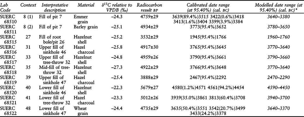
Radiocarbon dating (Gav Robinson)
Ten samples (Table 9) were submitted to the Scottish Universities Environmental Research Centre AMS Facility (SUERC) for radiocarbon dating. During the analysis associated with this project (NAA 2017, appx H), a programme of Bayesian modelling (Naylor & Smith Reference Naylor and Smith1988; Bayliss 2009; Reference Bayliss2015; Bayliss et al. Reference Bayliss, Plicht, van der, Bronk Ramsey, McCormac, Healy and Whittle2011, 19–59) of the unmodelled radiocarbon dates was undertaken using OxCal4.3.2 r5 (Bronk Ramsey 1995; Reference Bronk Ramsey2009). In the following text the models and queries used are indicated by keywords in bold. Calculated posterior ranges were rounded outwards to 10 years (Bayliss et al. Reference Bayliss, Plicht, van der, Bronk Ramsey, McCormac, Healy and Whittle2011, 21).
Table 9: radiocarbon results
* (see NAA 2017, appx H)
Radiocarbon ages quoted in conventional years bp (before ad 1950). The associated error, expressed at the 1 sigma level of confidence, includes components from the counting statistics on the sample, modern reference standard & blank, & the random machine error. The calibrated age ranges were determined from OxCal4.2.4 using the IntCal 13 atmospheric curve (Reimer et al. Reference Reimer, Bard, Bayliss, Beck, Blackwell, Bronk Ramsey, Buck, Cheng, Edwards, Friedrich, Grootes, Guilderson, Haflidason, Hajdas, Hatté, Heaton, Hoffmann, Hogg, Hughen, Kaiser, Kromer, Manning, Niu, Reimer, Richards, Scott, Southon, Staff, Turney and van der Plicht2013). The Bayesian modelling, however, was undertaken using a later version (OxCal4.3.2 r5; Bronk Ramsey Reference Bronk Ramsey1995; Reference Bronk Ramsey2009)
Pit 7: this feature produced 60 charred cereal grains and two grains (one of emmer wheat and one of barley) were submitted for radiocarbon dating. Prior to modelling (see below) the two dates from pit 7 were tested using the ‘R_combine’ function. These dates came from the same context but were shown to be statistically inconsistent via a chi-square test (df=1 T’=18.204 (T’(5%) 3.8)). It was assumed that these grains (and the others recovered from the feature) were from nearby activity prior to the infilling of the pit.
Grykes: The material chosen to date these features comprised: a hazelnut shell from deposit 40; hazel twig charcoal from 31; a wheat grain from context 48; and hazel charcoal from 30. The radiocarbon measurements achieved for the gryke deposits were modelled using the ‘Sequence’ function. This model had a good overall index of agreement (Amodel=100.1%, Aoverall=100.1%) and the individual indices were all above the required 60%.
Using just this simple model, an estimated ‘Span’ of deposition within the grykes was calculated. This indicated that the feature was likely infilled over between 2140 and 3540 years (probability of 68.2%), and potentially between 2050 and 5750 years (probability of 95.4%). The dates matched the stratigraphical sequence and, in general, agreed with the other available dating evidence. However, due to the presence of Early Neolithic pottery within context 40 and the robust nature of hazelnut shells, the fragment from this context was probably a remnant from earlier activity.
Tree-throw 32: Hazel charcoal from fill 41 and hazelnut shell fragments from the penultimate (35) and upper (33) deposits were submitted. The three measurements from this feature were first modelled as a simple ‘Sequence’ as each date was taken from a clear stratigraphical sequence. This produced a low index of agreement (A=56.4%) and low overall index of agreement (Amodel=60.5%, Aoverall=70.4%), suggesting some level of residuality or mixing between contexts. Another model treating the three dates as a simple ‘Phase’ of activity was also run to test the potential duration of infilling of this tree-throw. From this, a ‘Span’ was calculated. This indicated that the feature was likely infilled over a period of between 0 and 190 years (probability of 68.2%), and potentially between 0 and 680 years (probability of 95.4%).
Overall phase II model: The excavator suggested that the recorded contexts represented dumped (and/or slumped) waste from another source such as an above-ground midden. The test models added some weight to this theory. This mixing of material prior to deposition has been demonstrated in Early Neolithic contexts in Lincolnshire by Duncan Garrow (Reference Garrow2006, 36), and has been a common occurrence in archaeological contexts from a variety of time periods (see Orton Reference Orton2000, 40 & fig. 42; Gibson Reference Gibson2003, 140; Tipper Reference Tipper2004, 157–9).
Therefore, as is the case in many archaeological contexts that are not intentionally ‘placed’, not all the material within a context died or was discarded in the same year. However, it is possible, and in this case considered appropriate, to model the chronology of the pre-pit contexts of the Early Neolithic material to investigate the date and ‘Span’ of the activity that created it. This would refine the dating of the charred material and by inference, the discard of the pottery and other artefacts. Logically, with the seven available dates, this modelling should provide a fairly reliable chronology and time depth for this activity. The reliability of this modelling could be improved upon, in future, through increasing the number of radiocarbon dates from the contexts that produced pottery.
A simple Bayesian model for the combined Neolithic dates was constructed as a single ‘Phase’. This model (Fig. 13) had a good overall index of agreement (Amodel=107.2%, Aoverall=108%) and the individual indices were all above the required 60%. The posterior estimate for the start of Phase II produced by this model was during 3910–3700 cal bc (95.4% probability) and was likely during 3810–3720 cal bc (68.2% probability). The estimate for the end of the phase was during 3640–3430 cal bc (95.4% probability) and was likely during 3630–3540 cal bc (68.2% probability).
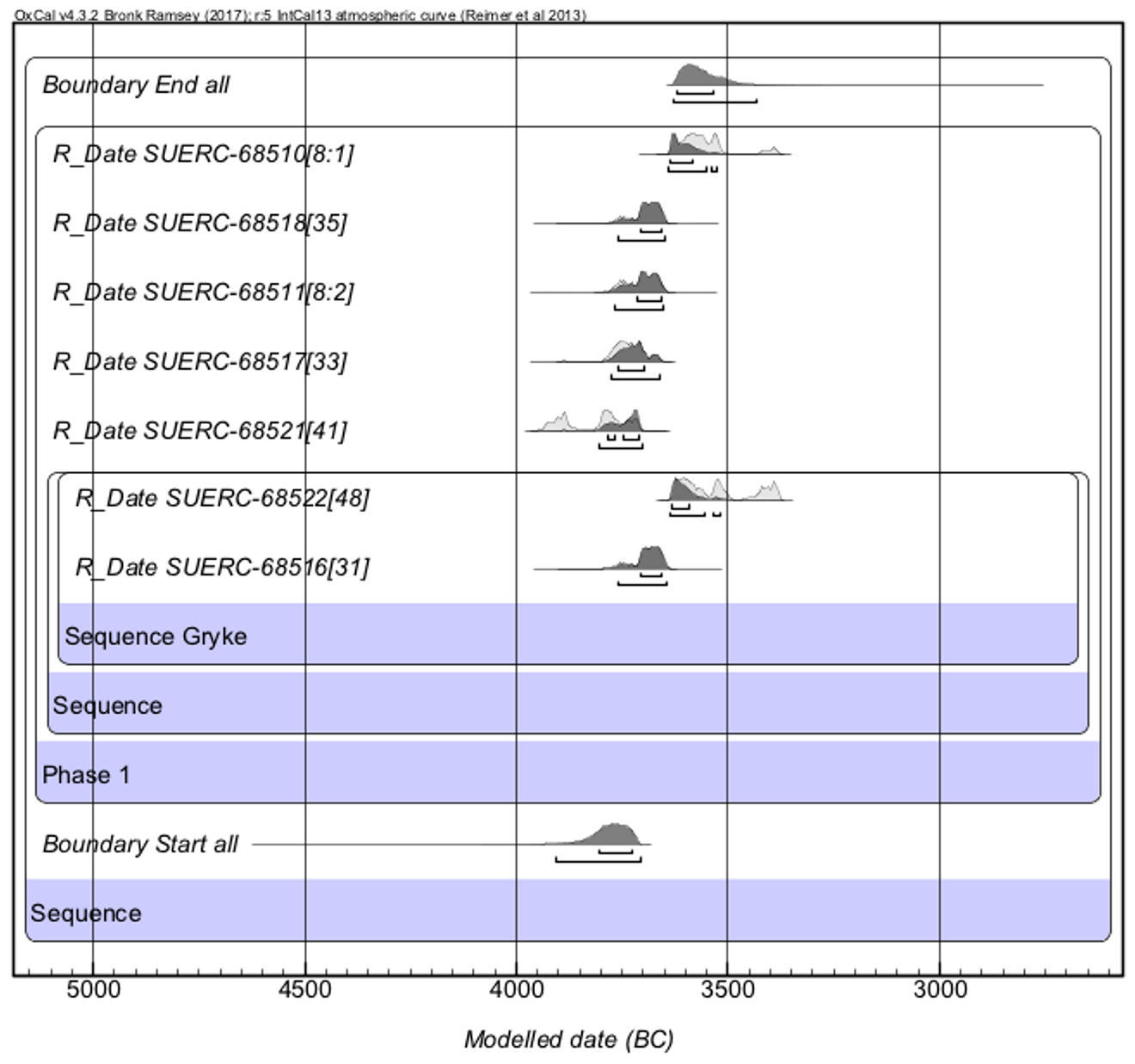
Fig. 13. Probability distributions of radiocarbon dates. Each distribution represents the relative probability that an event occurred at a particular time. Two distributions are plotted for each date; one in outline, which is the result produced by the scientific evidence alone, and a solid one, which is based on the chronological model. The model is defined by the boxes around the results and by the OxCal keywords
From this an estimated ‘Span’ of activity within the Neolithic of 90–430 years (probability of 95.4%) was calculated. This span was also likely to have been 120–270 years long (probability of 68.2%).
In general, the Bayesian modelling was successful in refining the chronology of the recorded contexts. Interestingly, the two dates from pit 7 and the poor match with the stratigraphy in tree-throw 23 were likely due to mixing prior to (or during) deposition. All the samples had close associations with the contexts they came from (see Waterbolk Reference Waterbolk1971) and, where present, all but one of the radiocarbon dates matched the broad artefactual dating.
The Bayesian modelling of the Phase II dates, therefore, represents a chronology for the nearby Neolithic activity that created the charred waste and the artefacts, and not necessarily the final infilling of the features directly.
Even so, the modelling has provided a statistical understanding of the time-depth of deposition within the grykes, tree-throw 32, and pit 7, and broad termini post quo for their infilling.
Additionally, the modelling of the Phase II contexts, some of which contained Early Neolithic carinated bowls, has provided a date range for their use/deposition of between 3910–3700 cal bc (95.4% probability) and 3640–3430 cal bc (95.4% probability), or between the 40th and 35th centuries cal bc. The deposition of the Early Neolithic pottery, whilst not directly dated, was almost certainly within this period.
Discussion
Taphonomy and interpretation
The association of artefacts and cremated bone with natural features, such as caves or limestone fissures, has often been attributed to burial or ceremonial traditions (Barnett & Edmonds Reference Barnett and Edmonds2002; Edmonds & Evans Reference Edmonds and Evans2007, 135; Evans Reference Evans2008, 128). Furthermore, the deliberate breaking of polished stone axes and/or their deposition either within pits or grykes (Bradley & Edmonds Reference Bradley and Edmonds1993, 166; Edmonds & Evans Reference Edmonds and Evans2007, 135–7; Evans Reference Evans2008, 127) has been suggested to be part of a wider tradition of deposition (Thomas 1999; Reference Thomas, Anderson-Whymark and Thomas2012, 5–9; Pollard Reference Pollard2001; Garrow 2006, 59; Reference Garrow2007, 11–2, 14).
At Sizergh Fell, near Kendle a ground stone axe, three flakes, and an upturned polissoir were recovered from within a gryke in the vicinity of a cairn (Edmonds & Evans Reference Edmonds and Evans2007, 122–3). Similar ‘caches’ of axes and associated material have been recorded close to several Cumbrian burial monuments (Evans Reference Evans2008, 117), including the Skelmore Heads long cairn, near Urswick (Fig. 14). Interestingly, similar caches were potentially recorded within the Stone Closes enclosure (Dobson Reference Dobson1912) and at High Haume, to the north of Dalton-in-Furness (Evans Reference Evans2008, 127). This evidence would seem to suggest that the remains recorded at Stainton Quarry resulted from a similar tradition. The prominent location upon the southern limit of a limestone ridge, its proximity to a potential spring (see Wild Reference Wild2003, 43; Evans Reference Evans2008, 83, 112–3), the potentially contemporary nearby enclosure at Stone Closes, the deliberately broken stone axes, and the mix of material recovered from the grykes, could all be interpreted as evidence for ‘meaningful’ deposition as part of some form of ceremonial activity (Becket & MacGregor Reference Becket, MacGregor, Anderson-Whymark and Thomas2012, 61).
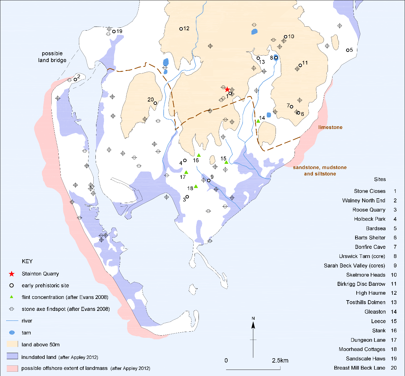
Fig. 14. Early prehistoric evidence in Furness
The interpretation of the Stainton Quarry evidence, however, is problematic without careful assessment of the associated processes of formation and taphonomy. Failure to do so would result in a misreading of the data, which was, by the nature of the project and the evidence itself, skewed by several factors. First, as is common on sites in Cumbria (Hall & Huntley Reference Hall and Huntley2007, 27), the soils were unfavourable for the preservation of animal bone. Additionally, the focus of activity may have been to the east, outside the excavated area. Also, the deep overlying soils indicated that the area had been ploughed. These factors suggested that the features may have been part of a wider area of activity and past ploughing may have removed or dispersed any associated above ground remains and/or shallow cut features.
The concentrations of artefacts and ecofacts within the upper portion of tree-throw 32 and sinkholes within the grykes were mixed, containing lenses of differently coloured silt, sand, and clay. The artefacts and stones within these were not ‘placed’ but followed a complex series of tip lines. This could indicate that the deposits were shovelled or had possibly slumped into the features, either from different sources (spoil heaps) or from a source that was already mixed (or layered), such as an above ground midden. The measured radiocarbon dates and Bayesian modelling also suggested some level of mixing prior to deposition amongst the ecofacts. Additionally, the 11 sherds (SG4) of Early Neolithic pottery recovered from within the turf layer removed from bedrock 20 hint at the former presence of an above ground midden in his area.
The presence of such ‘pre-pit contexts’ has been suggested by Garrow (Reference Garrow2006, 40) during his extensive investigation into the Neolithic pits of East Anglia. Garrow (ibid., 36) also stated that the artefacts within the Early Neolithic pits were a mix of occupational waste that had been dumped as a mass of material rather than being placed. This lack of ‘structure’ within the deposition was similar to that recorded at Stainton Quarry but was not necessarily the result of ceremonial behaviour (Rowley-Conwy Reference Rowley-Conwy, Burenhult and Westergaard2003, 124; Harding Reference Harding2006, 109; Bishop et al. Reference Bishop, Church and Rowley-Conwy2009, 84; Rowley-Conwy & Owen Reference Rowley-Conwy and Owen2011, 352; contra Pollard Reference Pollard2001, 323; Garrow Reference Garrow2006, 36; Thomas Reference Thomas, Anderson-Whymark and Thomas2012, 5).
The idea of above ground piles of waste around areas of past human occupation of any period should not be problematic (for instance see Gibson Reference Gibson2003, 140; Tipper Reference Tipper2004, 157–9; Garrow Reference Garrow2006, 38; Millett Reference Millett2006, 25, 79 & 89). Indeed, a mixed soil matrix containing abraded pottery sherds, pitchstone, flint, quartz, and charred hazelnut shells recorded at The Carrick, on the banks of Loch Lomond, was potentially a remnant of an Early Neolithic midden (Becket & MacGregor Reference Becket, MacGregor, Anderson-Whymark and Thomas2012, 57).
This probability – that the deposits recorded at Stainton Quarry were either intentionally backfilled from another source or were part of the natural slumping of a midden – is crucial in interpreting the artefacts, the activities that produced them, and the meaning of their deposition. Indeed, this consideration would seem to help explain the distribution of finds across bedrock outcrop 20, as well as the dearth of similar material in similar solution features in the other areas of the site.
With regard to the deposition of the axe fragments, the seemingly ceremonial deposition of a polished axe and related items at Sizergh Fell (Edmonds & Evans Reference Edmonds and Evans2007, 123) was markedly different to that at Stainton Quarry. At Sizergh, the collection of related items was placed near the top of a gryke on the surface of a ‘sterile’ natural deposit (Helen Evans pers. comm.). Conversely, at Stainton the axe fragments were within a mixed matrix of soil, sand, clay, charcoal, and other artefacts.
Both the Stainton Quarry axes were finished items that had been deliberately broken across their width potentially to form a platform from which flakes were struck. Deposition of deliberately broken axes is sometimes attributed to ceremonial traditions (Bradley & Edmonds Reference Bradley and Edmonds1993, 52, 166; Williams & Kenney Reference Williams and Kenney2009; Becket & MacGregor Reference Becket, MacGregor, Anderson-Whymark and Thomas2012, 58). However, the ‘mundane’ reuse of broken axes as rubbers or hammerstones (Manby Reference Manby1965, 16–7), and the retouching of detached flakes into tools, such as scrapers (Manby Reference Manby1965, 16–7; Bradley & Edmonds Reference Bradley and Edmonds1993, 48; Evans Reference Evans2008, 30), are well documented. This suggests that the axe heads recovered at Stainton may have been broken to reuse the stone to produce flakes for tool manufacture. Consequently, their disposal could have been as mundane as the discarding of any fragment of debitage. Their inclusion with other ‘domestic waste’ may have therefore been completely coincidental.
Environment, subsistence and permanence of place
Little direct data exist to characterise Early Neolithic occupation within the Furness region (Evans Reference Evans2008, 120). This is in part due to the small number of excavations undertaken to date. However, recent developer-funded projects (Fig. 14), including work at Roose Quarry (Jones Reference Jones2001; OAN 2014), Holbeck Park Avenue (OAN 2002; Evans Reference Evans2018), Walney North End (Greenlane Archaeology 2015), Sandscale Haws (Evans & Coward Reference Evans and Coward2004), and to the north-east of Stainton Quarry (Greenlane Archaeology Reference Archaeology2012), have confirmed expectations that this region contains regionally, if not nationally, important evidence (Manby Reference Manby1965, 3; Evans Reference Evans2008, 118; Bradley et al. Reference Bradley, Rogers, Sturt and Watson2016, 143).
A combination of the antiquarian and modern evidence, as well as fieldwalking and palaeoenvironmental data (and the reconstruction of the ancient coastline), have provided a broad (if blurry) characterisation of the area during the transition into the Early Neolithic period (Hodgkinson et al. Reference Hodgkinson, Huckerby, Middleton and Wells2000, 35–6; Evans Reference Evans2008, 118–39; Appley Reference Appley2012). Pollen core evidence from Urswick Tarn (Oldfield & Statham Reference Oldfield and Statham1963; Grosvenor Reference Grosvenor2014) and the Sarah Beck Valley (Appley Reference Appley2012) has demonstrated minor disturbances within the extensive woodland cover prior to the more widespread changes associated with the ‘elm decline.’ A lack of cereal pollen and associated weed seeds, and the presence of plantain and grasses, led to the suggestion that these early clearances were for the grazing of domestic animals rather than for the cultivation of crops (Oldfield & Statham Reference Oldfield and Statham1963; Hodgkinson et al. Reference Hodgkinson, Huckerby, Middleton and Wells2000, 35; Evans Reference Evans2008, 126; Appley Reference Appley2012, 209; Grosvenor Reference Grosvenor2014, 293).
The nature of this woodland, however, was probably different upon the Furness limestone uplands than on the lower-lying coastal sandstones (Spikins Reference Spikins1999). During the terminal Late Mesolithic (c. 6000 bp; c. 5000–4700 cal bc), ash dominated woodland was probably present in the limestone uplands and oak in coastal areas (ibid., fig. 5.17). These woodlands were unlikely closed canopy forests suggested by early palynological studies (Evans Reference Evans2008, 19; Simmons Reference Simmons2003, 23), especially in more upland areas (ibid., 43). Furthermore, the poor soil-cover (ibid., 167; Evans Reference Evans2008, 125) in the limestone areas around Stainton Quarry would have supported a more open woodland than in the lowlands. Charcoal identifications at Stainton Quarry complemented this evidence, with willow or poplar, oak, hazel (and possibly alder), rose-family, and guelder rose being recovered from contexts likely dating to the Early Neolithic.
In the Furness Peninsula, and indeed the wider Cumbrian region, few sites have provided actual evidence of Early Neolithic subsistence. This dearth of evidence should not, however, be considered evidence of an absence (Sagan Reference Sagan1995). The data recovered at Stainton Quarry, though limited when compared to more prolific Scottish sites, such as Warren Field (Murray et al. Reference Murray, Murray and Fraser2009) and Balbridie (Historic Environment Scotland 2017), is important.
A total of 121 fragments of charred hazelnut shell, 70 cereal grains, and eight fragments (1.6 g) of indeterminate bone were recovered from Early Neolithic contexts recorded at Stainton Quarry. These items comprise little more than a couple of handfuls of fragments but represent the largest Early Neolithic palaeobotanical assemblage recovered from Furness, and potentially Cumbria, to date.
Absorbed residue analysis upon 17 pottery sherds produced evidence for the processing of dairy fats from nine samples. This represents the first evidence of Early Neolithic dairying in Cumbria and complements studies at a timber hall at Warren Field, Aberdeenshire (Šoberl & Evershed Reference Šoberl and Evershed2009), a ‘scoop house’ at Garthdee Road, Aberdeen (Cramp Reference Cramp2014, 50–3), as well as a larger study of northern sites (Cramp et al. Reference Cramp2014). Conversely, these results differed from analysis undertaken on pottery sherds recovered from Oversley Farm, Cheshire (Dudd & Evershed Reference Dudd and Evershed2007).
These findings suggest that the Early Neolithic residents of Stainton Quarry were engaged in cereal production and animal husbandry (including the use of secondary products), as well as the consumption of hazelnuts. In short, the they were engaged in a mixed farming strategy with an element of utilisation of wild resources. The combined subsistence data, with taphonomical considerations in mind (Bishop et al. Reference Bishop, Church and Rowley-Conwy2009, 79–82), is in line with the evidence for mainland Scotland and seems to fit well within wider studies that propose some settled farming communities in some regions of the UK during the Early Neolithic (Bishop et al. Reference Bishop, Church and Rowley-Conwy2009, 90; Sheridan Reference Sheridan, Finlayson and Warren2010, 98). However, these models include elements of variability in both the subsistence strategies pursued and how these changed with time.
It has been stated that the distinction between a Neolithic ‘settlement’ and a burial, ritual, or ceremonial site may not have been as important to the creators as it seems to modern observations (Thomas 1996, 7–8; 2004; Reference Thomas and Thomas2007, 265; Brück Reference Brück1999; Gibson Reference Gibson2003, 136). However, like their Mesolithic predecessors (see Bailey & Spikins Reference Bailey and Spikins2008), Early Neolithic people of the UK and Ireland (regardless of their subsistence strategy) created settlements (Gibson Reference Gibson2003). To suggest otherwise would be a rejection of the available data. Whether these were temporary camps or semi-permanent and/or permanent farmsteads (Pollard Reference Pollard and Ritchie2000, 36; Armit et al. Reference Armit, Murphy, Nelis and Simpson2003b, 1–2; Cooney Reference Cooney2003, 47; Rowley-Conwy Reference Rowley-Conwy2004, 93; Becket & MacGregor Reference Becket and MacGregor2009; Sheridan Reference Sheridan, Finlayson and Warren2010, 97–8) or even villages (Rathbone Reference Rathbone2013) can only be elucidated on a site-by-site basis through a vigorous interrogation of the evidence.
Landscapes and mobility
Considering the range of known Early Neolithic evidence across the varied landscape of the Furness Peninsula (Fig. 14), a pattern (though obviously still incomplete) begins to emerge. A potential hierarchy of sites existed; some typified by small lithic scatters, whilst others, like Walney North End and Gleaston, represent places of more permanence (see Evans Reference Evans2008, 126; Milner Reference Milner, Bailey, Cummings and Whittle2005). If a mobile, shifting cultivation model of Early Neolithic subsistence is accurate (Evans Reference Evans2008, 126), then the latter sites would be places of repeated occupation. Alternatively, if this was not the case (see Rowley-Conwy Reference Rowley-Conwy2004, 93), then these could have been longer-lived, similar to a settlement at Oversley Farm, Cheshire (Dudd & Evershed Reference Dudd and Evershed2007). Stainton Quarry, when considered within its immediate landscape and in the context of the finds from Stone Closes, seems to have been the site of similar repeated or permanent Early Neolithic settlement.
Conclusions: Furness’S first farmers?
The archaeological mitigation works undertaken at Stainton Quarry have revealed regionally significant prehistoric remains relating to the early farming communities of the Furness Peninsula. Evidence that the occupants of the site raised crops, tended cattle, and gathered hazelnuts was recovered, suggesting they followed a mixed subsistence strategy. Absorbed residue analysis undertaken as part of this project provided the first Cumbrian evidence for the use of dairy products during the Early Neolithic period. Additionally, the presence of a pitchstone core from Arran and two broken axe heads from the Langdale quarries indicated that the denizens were connected to a wider exchange network that linked Ireland, Cumbria, Scotland, and potentially Wales (Bradley et al. Reference Bradley, Rogers, Sturt and Watson2016).
The assemblages of artefacts and ecofacts retrieved are suggestive of Early Neolithic domestic occupation, the focus of which probably lay to the east beyond the stripped area. Radiocarbon dating confirmed the artefactual dating, as well as indicating an earlier presence during the 46th–45th centuries and later activity during the Chalcolithic and Early Bronze Age.
Evidence previously recorded in the vicinity raised the possibility that the area, including the now destroyed Stone Closes enclosure, was likely a long-lived focus of activity. This activity may have been related to settlement, farming, and the polishing of stone axes (Manby Reference Manby1965, 4). Alternatively, considering the possibility that the enclosure may have been a ‘causewayed camp’ (NAA 2017; but see Oswald et al. Reference Oswald, Dyer and Barber2001), it may have been a focus of ceremonial activity and/or the deposition, and/or exchange of axes (Bradley & Edmonds Reference Bradley and Edmonds1993, 50–2; Evans Reference Evans2008, 128).
The deposits and assemblages of artefacts and ecofacts recorded at Stainton Quarry have parallels in the Furness Peninsula at Holbeck Park Avenue and Roose Quarry, as well as at other sites previously recorded around the fringes of the Irish Sea (see NAA 2017). Comparisons with these have demonstrated that the closest parallel was at Billown on the Isle of Man (Lancaster University Archaeological Unit 1992; Darvill Reference Darvill2003), where occupation associated with an Early Neolithic enclosure was recorded. This occupation was interpreted as short-lived (Darvill Reference Darvill2003, 119) although it could be argued that this was an assumption rather than apparent from the evidence (see Rowley-Conwy Reference Rowley-Conwy2004, 93). Such camps, whether defined by scatters of pits, post- and stake-holes, construction trenches, or structures around oval or amorphous hollows, could easily be the truncated remains of long-lived settlements. Substantial long-lived structures can be constructed with relatively shallow foundations (see Tipper Reference Tipper2004, fig. 18; English Heritage 2014).
Structures recorded at the long-lived site at Oversley Farm, Cheshire (Garner Reference Garner2007) clearly demonstrated this. At this site, which produced comparable assemblages of material to those recovered at Stainton Quarry, a later Neolithic house was constructed over the footprint of an Early Neolithic structure. The buildings were defined by partial foundation trenches which if destroyed by later activity, would have left what would have been interpreted as a temporary camp or ‘pit site.’
The presence of cultivated crops, pottery, and other heavy items such as stone axes, when considered alongside the practicalities of the labour-intensive activities undertaken including raising crops (Rowley-Conwy Reference Rowley-Conwy2004, 92; Jones & Rowley-Conwy Reference Jones, Rowley-Conwy, Colledge and Conolly2007), managing hazel stands (McComb Reference McComb, McCartan, Schulting, Warren and Woodman2009, 229), tending livestock (such as pigs; Rowley-Conwy Reference Rowley-Conwy2004, 96; Grigson Reference Grigson, Bell and Limbrey1984, 299), coppicing (Tomii Reference Tomii1996; Rowley-Conwy Reference Rowley-Conwy2004, 96), polishing axes (Bradley & Edmonds Reference Bradley and Edmonds1993, 49), and potentially constructing enclosures would seem to suggest a more sedentary lifestyle than is often stated.
The excavations at Stainton Quarry and the associated analyses have demonstrated that the Furness region contains a largely untapped potential with regard to understanding the Early Neolithic farmers of Cumbria. The data recovered during the project have shown that evidence relating to the most elusive of transitions can be found in the most unexpected locations. Equally, the project has highlighted the importance of diligent palaeoenvironmental sampling, radiocarbon dating and residue analysis.
Acknowledgements
NAA would like to give thanks to the following individuals and organisations for their contributions to this project. First and foremost, we extend our gratitude to Tarmac Ltd, whose co-operation and financial support made this project possible. The Tarmac team involved were Gary Cumberbatch and Matthew Pixton. We would also like to thank Jeremy Parsons and Mark Brennand of Cumbria County Council Historic Environment Service (CCCHES) for their guidance and advice. The archaeological fieldwork was directed by the authors and special thanks must go to Damien Ronan (surveying), Lynne Gardiner and Becky Fraser (logistics), and the digging team, whose professionalism and dedication was instrumental in the discoveries presented within this report: Rory Abrahams, Maya Hoole, Kevin McHugh & Julian Thorley.
Special thanks are also due to those who supported the project behind the scenes including Matthew Town and Hannah Russ (management), Frederick Foulds, Andy Crowson, Helen Devonshire and Greg Speed (editing), Sarah Parker (admin), Roger Simpson (illustration), Damien Ronan (CAD), Dawn Knowles (CAD), Cath Chisman (CAD), David Griffiths (finds), Elizabeth Foulds (finds), Chrystal Antink (finds), and Lynne Gardiner, Freddie Sisson, and Megan Lowrie (palaeoenvironmental). In addition to the named contributors, we would also like to thank Craig John Appley, Jonathon Elmer (Elmer Ecology), Dan Elsworth (Greenlane Archaeology), Helen Evans and Fraser Brown (Oxford Archaeology North), Dave Fell, Malin Holst (University of York), Jane Kenney (Gwynedd Archaeological Trust), Catherine Rees (C.R. Archaeology), Melanie Roffet-Salque (University of Bristol), and Peter Rowley-Conwy (Durham University) for their kind assistance.


