


INTRODUCTION
Presented in this paper is an initial set of radiocarbon (14C) dates from Late Bronze occupation levels unearthed at Tel Azekah in southwest Israel. The site of Azekah is located within the Shephelah region, characterized by low hills and fertile valleys connecting the coastal plain with the Judean highlands (Figure 1). During the Late Bronze Age it was among the more populated regions, its Canaanite society organized in a city-state system dominated by Lachish, Gezer, and Gath (Finkelstein Reference Finkelstein1996; Na’aman Reference Na’aman1997, Reference Na’aman2011). Positioned quite close to the border of Egypt, the Shephelah region felt strongly the waxing and waning of Egyptian control through the Late Bronze Age, with political interaction best attested in the Amarna corpus (Moran Reference Moran1992; Na’aman Reference Na’aman2011).

Figure 1 Map showing the position of the Shephelah and sites mentioned in the text.
The relative chronology of the Late Bronze Shephelah is well understood from local ceramic typology (e.g. Yannai Reference Yannai2004; Panitz-Cohen Reference Panitz-Cohen2006, Reference Panitz-Cohen2014:550–2; Gadot et al. Reference Gadot, Yasur-Landau and Uziel2012). The period divisions and absolute chronology of the Late Bronze Age in the southern Levant, however, remain strongly dependent upon connections with Egypt (Mazar Reference Mazar1990:238–9; Martin Reference Martin2011:1820; Panitz-Cohen Reference Panitz-Cohen2014:542). While the New Kingdom (high) chronology now finds support in 14C data (Dee Reference Dee2013), 14C sequences are needed to develop independent locally based chronologies. An excellent dataset is available for northern Israel (Megiddo; Toffolo et al. Reference Toffolo, Arie, Martin, Boaretto and Finkelstein2014), but no similar sequence has been published for southern Israel. For the Shephelah, isolated dates from a number of sites have been published,Footnote 1 and more recently a sequence dealing with the Late Bronze to Iron Age (LB-IA) transition (Tell es-Safi/Gath; Asscher et al. Reference Asscher, Cabanes, Hitchcock, Maeir, Weiner and Boaretto2015a); Lachish offers the only sequence spanning the LB IIA to LB III,Footnote 2 however, it includes few short-lived samples (Carmi and Ussishkin Reference Carmi and Ussishkin2004).
A particularly intriguing question characterizing the LB-IA transition, is the date of first appearance of the “Philistine 1” pottery style that is usually associated with Philistine settlement in southwest Canaan. Scholars have debated for several decades how to interpret the fact that this pottery appears at Ekron Stratum VIIb, but is completely absent from Lachish Level VI, which otherwise seemed contemporaneous. Ussishkin (Reference Ussishkin1985:222–3, Reference Ussishkin2004a:72–73, Reference Ussishkin2007), followed by Finkelstein (Reference Finkelstein1995, Reference Finkelstein1998, Reference Finkelstein2000, Reference Finkelstein2007) claims this shows Ekron VIIb was settled only after the destruction of Lachish VI, thereby offering a date of 1130 BCE for the appearance of so-called “Philistine” pottery (see further explanation of this dating below). Others have offered alternate explanations for the discrepancy between the two neighboring sites and retained the more traditional middle chronology dating of 1180 BCE for the introduction of this pottery style (Mazar Reference Mazar1985, Reference Mazar1997, Reference Mazar2007; Singer Reference Singer1985; Stager Reference Stager1985, Reference Stager1998; Bunimovitz and Faust Reference Bunimovitz and Faust2001; Master et al. Reference Master, Stager and Yasur-Landau2011). A recent publication of a 14C sequence dealing with the LB-IA transition offered an even higher date (Tell es-Safi/Gath; Asscher et al. Reference Asscher, Cabanes, Hitchcock, Maeir, Weiner and Boaretto2015a). Yet no Philistine 1 pottery has been found at Azekah (Kleiman et al. Reference Kleiman, Gadot and Lipschits2016), just 8 km away from Tel es-Safi/Gath, making the discrepancy even stronger. Clearly 14C dates from Azekah can contribute much to this discussion.
Excavations since 2012 at Tel Azekah—in the heart of the Shephelah—have revealed a thriving Late Bronze Age town. This article presents initial 14C data and Bayesian models for short-lived samples retrieved from five Late Bronze occupation layers. The results are compared with new models for Lachish, as well as other published data from Cisjordan, thereby providing a fresh perspective on the chronology of southwest Canaan during the later LB and transition to the Iron Age.
TEL AZEKAH
Tel Azekah (Tell Zakarîya)Footnote 3 is situated on the northern end of a north-south hill range that forms a boundary between the higher and lower Shephelah (Figure 2). Perched 127 m above the Valley of Elah (Nahal HaElah or Wādi ‘Ajjur), which winds along the eastern and northern sides of the site, Tel Azekah dominates the local landscape. The site watches over—and no doubt was used to control—the strategic junction of roads leading from Tell eṣ-Ṣafi/Gath in the west (8 km) to the Judean Highlands in the east, and from Beth Shemesh in the north (6 km) to Lachish in the south (17 km).
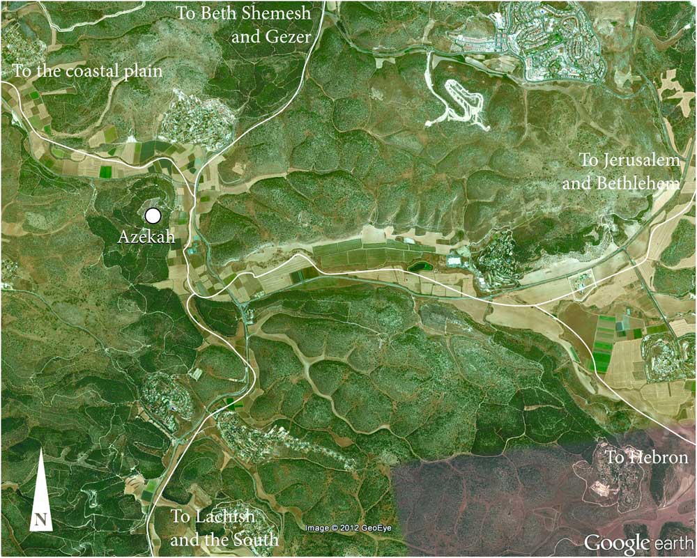
Figure 2 Strategic location of Tel Azekah in the heart of the Shephelah (image courtesy of Google Earth).
The site is naturally defensible, with three steep sides (Figure 3). The only practical approach is from the south, where Tel Azekah is joined to the ridge by a low saddle. The site covers an area of 4.5 ha and is roughly triangular—its base at the southwest and narrowest tip inclined towards the northeast. The summit is flat except for a 6 m higher acropolis (0.6 ha) in the southeastern corner. Artificial low terraces surround the southern and southwestern slopes of the tell.

Figure 3 Aerial photo from 1945 in which the lower city terracing is evident (left). Excavation areas of the current expedition (right, prepared by N Erskine). The two areas of primary interest are circled.
Tell Zakarîya was identified as the site of biblical Azekah by Schwarz (Reference Schwarz1850:102) in the middle of the 19th century. Azekah is mentioned in the Hebrew Bible (Josh 10:10–11; 15:35; 1 Sam 17:1; Jer 34:6–7; Neh 11:30; 2 Chr 11:5–10) and in extra-biblical sources, usually as one of the border towns of the Kingdom of Judah, which underscores the geopolitical importance of the site (Lipschits et al. Reference Lipschits, Gadot and Oeming2012:197–8). The name of the site is, however, unknown from sources dating to the second millennium BCE.
The site was first excavated in 1898 and 1899 by F J Bliss and R A S Macalister on behalf of the British Palestine Exploration Fund (Bliss and Macalister Reference Bliss and Macalister1902; see further Napchan-Lavon et al. Reference Napchan-Lavon, Gadot and Lipschits2015). In the last quarter of the 20th century, Dagan conducted a regional survey of the Shephelah, which included Tel Azekah (Dagan Reference Dagan2011:77, Table 2). In 2009, as part of preparations for the renewed excavations, an intensive survey was carried out at Tel Azekah by Emmanuilov (Reference Emmanuilov2012). Pottery dating to the Early Bronze II-III, Middle Bronze II, Late Bronze I-II, Iron II, the Persian, Hellenistic, Roman, Byzantine, and Early Islamic periods was documented. The finds show that the site reached its zenith in the Late Bronze Age II and the Iron Age II, with an occupation gap during the Iron I.
Five excavation seasons have been conducted by the Lautenschläger Azekah Expedition since 2012 (Lipschits et al. Reference Lipschits, Gadot and Oeming2017).Footnote 4 Seven areas (Figure 3) were excavated along the southern (Area S1), eastern (Areas E1 and E3), western (Areas W1, W2, and W3), and northern (Area N1) slopes. Area S2 was opened on the southern lower terrace of the site, and Areas T1 and T2 on the top of the mound. The new excavations have confirmed the site’s long occupation history, from the Early Bronze III through to the Roman period. The Late Bronze Age is the most notable period, with occupation remains uncovered in eight of the ten excavated areas. The main data thus far obtained for the period derives from Area T2—located on the top of the mound close to the acropolis, and Area S2—located on the lower terrace that formed an extra-mural quarter of the town. Area T2 features an LB III occupation layer, ending in a thick burnt destruction layer which preserved a large ceramic assemblage, numerous small finds and the remains of four individuals who clearly perished in this dramatic event (Metzer Reference Metzer2015; Kleiman et al. Reference Kleiman, Gadot and Lipschits2016). The destruction was widespread, with evidence encountered also in Areas S2, E3, W2, and N1. Area S2 includes occupation layers spanning much of the Late Bronze occupation, from LB IIA to LB III. The Late Bronze phases in Areas S2 and T2 have become the focus of the current 14C dating project at Tel Azekah, and are the subject of the following discussion.
STRATIGRAPHY OF THE EXTRA-MURAL QUARTER, AREA S2
Area S2 features at least four occupation levels dated to the Late Bronze Age (Table 1). Plans are included in the supplementary online material, Figures X1–4. Excavation of earlier levels is too limited to ascertain whether the LB I is also present here.
Table 1 Late Bronze Age stratigraphy of Area S2.

The most prominent architectural feature of the extra-mural quarter is a deep rock-cut depression that may have originally been used as a water reservoir (Phase S2-8; refer to Figure 4). Regardless of the initial function and date of the depression, it is clear that by Phase S2-7 it went out of its original use and a building was constructed within it. Only two walls were attributed to the earliest building phase (S2-7), but these are too scanty to date. The next occupation level (S2-6) is dated by the pottery to the LB IIA and consists of one wall (13/S2/F559) and an adjoining plaster floor (13/S2/F565). While the limited exposure of this level does not allow reconstruction of a clear plan, nor the function of the structure, the extent of the floor shows that by the LB IIA a large building existed within the rock-cut depression. An Egyptian bifacial plaque found out of context in Area S2 exhibits iconographic motifs dated to the mid-18th Dynasty, further attesting to human activity in the extra-mural quarter during the LB IIA (Kleiman et al., Reference Kleiman, Koch, Linares, Sergi, Webster, Gadot and Lipschitsforthcoming). If the extra-mural quarter of the town was inhabited during the LB IIA, it should be assumed that the entire town—also on top of the mound—was settled as early as this period. This assumption finds further support in a sherd of a White Slip II Type 2 Cypriot krater found in a fill in Area W1—a very rare find in the southern Levant, and securely dated to Late Cypriot IIB which corresponds to the Levantine LB IIA (Yasur-Landau et al. Reference Yasur-Landau, Gross and Gadot2014).

Figure 4 Monumental building of S2-5a-b.
The next occupation level is Phase S2-5b and is dated by pottery to the LB IIB. It is characterized by the erection of a new monumental public building within the rock-cut depression, burying the earlier structure below it. The building consists of two longitudinal rooms separated by a massive wall made of unworked boulders (13/S2/F563). The boulders clearly intersect the floor of the former building (S2-6, 13/S2/F565) and thus postdate it. This building was enlarged during the next occupation phase (S2-5a), a new floor constructed (13/S2/F556) and a row of pillars (13/S2/F555) added on the west end of the western room. The pillars were laid on the edge of an artificial “step” created in the bedrock, thus creating a third longitudinal but especially narrow room to the west. Though the exact nature and function of this building (with its two sub-phases, S2-5a-b) could not be determined, the use of large boulders together with the scale of building activity needed to erect them within the depression imply that they were not merely of a domestic nature. Mud-brick debris and a few in-situ broken vessels found on the floors of the later “Pillar” building (S2-5a) indicate that it was destroyed or abandoned sometime during the LB IIB.
The entire layout of the extra-mural quarter was changed in Phase S2-4, dated to the LB III: the rock-cut depression was filled with earth and stones, burying the former buildings and creating a level space on which an open paved plaza was built. The plaza incorporated a cistern and a stone silo, alongside a new building that probably functioned as a warehouse (based on the large number of typical “Canaanite” storage jars found smashed on the floor). The public plaza and adjacent building were found under thick destruction debris. The pottery assemblage found within the destruction is similar typologically to the assemblage found and published from the destruction layer in Area T2 (Kleiman et al. Reference Kleiman, Gadot and Lipschits2016) and hence seems to date to the end of the LB III. Following the destruction of the public plaza, the extra-mural quarter was abandoned and its habitation resumed only in the Iron Age IIB.
STRATIGRAPHY OF AREA T2
In this area a wide exposure of the final Late Bronze occupation at Azekah was made (Phase T2-3, LB III). Earlier phases of the Late Bronze Age have not yet been excavated to a significant extent here. Phase T2-3 (plan provided in Figure X5) features a building which is part of a large architectural compound (12/T2/F627) that incorporated at least four rooms. The structure was established in Sub-phase T2-3b. Architectural modifications during Sub-phase T2-3a concern mainly room 12/T2/F628, where the character of the space changed markedly: two walls (12/T2/F533 and 12/T2/F545) were added, the floor was raised over previous pillar bases, and an elaborate grinding installation (12/T2/F539) was added. The T2-3a occupation ended in a clear destruction event. Beneath a thick layer of mudbrick debris with strong evidence of burning, a large ceramic assemblage and numerous finds were recovered (Kleiman et al. Reference Kleiman, Gadot and Lipschits2016). Four skeletons attest to the suddenness of the event that ended the Late Bronze era at Tel Azekah. As in Area S2, occupation did not resume until Iron Age II (Phase T2-2).
14C DATING APPROACH AND METHODS
Obtaining precise 14C dates for the period between the late 13th and mid-11th centuries BCE is challenging, as the calibration curve is characterized here by wiggles and short plateaus (Figure X6; see also Manning Reference Manning2006-2007). Consequently, 14C ages with good measurement precision calibrate to calendar dates with a 95.4% probability range of ~200 yr. To obtain absolute dates with adequate precision for the LB IIB-III, it is essential to work with samples from stratigraphic sequences: by combining prior information about stratigraphic order with the 14C data using Bayesian statistical modeling, the precision of the resulting chronological information can be greatly improved (Buck et al. Reference Buck, Kenworthy, Litton and Smith1991, Reference Buck, Litton and Smith1992; Bronk Ramsey Reference Bronk Ramsey2009a). Sequences from single excavation areas are preferred where possible; these lead to the most robust models since the samples are linked by direct stratigraphic observations (without need for connections via pottery typology). The authors wish to emphasize that the data and models presented here form a starting point only. The quantity of data is currently limited, and hence the models are still quite imprecise. Adequate measurement statistics, not only good quality contexts, is important for building robust and precise 14C-based chronological models.
Sample Selection—Area S2
Three successive phases of Area S2 spanning LB IIA-B have been 14C dated: S2-6, S2-5b, and S2-5a. No suitable samples for dating the last Late Bronze phase (S2-4) were available for inclusion in the initial dataset. Dates for LB III at Azekah are, however, available from Area T2, Phase T2-3a which we consider contemporary with Phase S2-4. As listed in Table 2, three contexts from S2-5a have been dated, two from S2-5b, and one from S2-6. The stratigraphic association of two other contexts originally associated with S2-6 (14/S2/L378 and 14/S2/L384) had to be abandoned on the basis of subsequent excavation showing they derive from a pit (see discussion below). All samples were associated with floors, with the exception of the two pit-related contexts. Most were obtained while dismantling the floors and hence their deposition most likely reflects time of construction.
Table 2 14C dates obtained for the Late Bronze Age occupation sequence in Areas S2 and T2 of Tel Azekah. All samples are carbonized olive pits.

From each context multiple olive pits were obtained, but only one context yielded a clear cluster (15/L404/B21860); clusters are of course preferable over single seeds since they carry a lower risk of being residual or intrusive. A single olive pit was dated from each context, except for the cluster, from which three were dated.
Samples OZS882 (14/S2/L378) and OZS883 (14/S2/L384) were obtained from a probe dug at the north end of square J6 during 2014 (Figure 5). When selected and submitted for dating (prior to the 2015 excavation season), both contexts were understood to pre-date Phase S2-5b, the “Boulder Building.” The upper context (14/S2/L378) was considered part of the S2-6 floor, below which a possible pit was evident in section. The lower context (14/S2/L384) was understood to be either another floor or a well-stratified layer of the pit. The presence of a pit (15/S2/F590) became clear during the 2015 season when the adjacent baulk (sq. J6/J7) was excavated (Figure 5). The pit, which seems to be a foundation deposit, was initially thought to be sealed by the S2-6 floor (13/S2/F565). Following the excavation season, however, uncertainties were raised about the phase attribution: both the pottery and two 14C dates from the probe (OZS882 and OZS883) suggested that the pit had penetrated from higher above. Both OZS882 and OZS883 should be understood as deriving from a foundation deposit of the monumental building (either Sub-phase S2-5b or S2-5a).

Figure 5 Pit 15/S2/F590 seen in section (left). Probe dug in 2014, next to the baulk in which 15/S2/590 was identified (right). Samples OZS883 and OZS882 were obtained within the probe.
Parts of the S2-6 floor—well away from pit 15/S2/F590—were excavated in 2015. In square J6 a new short-lived sample was obtained to date this phase. A cluster of seeds (15/L404/B21860) was found embedded in floor plaster at the point where it abuts wall 13/S2/F559. The floor (13/S2/F565) can be readily attributed to S2-6 due to the following stratigraphic observations: (1) it was cut by the main “Boulder Building” wall (13/S2/F563); (2) both floor 13/S2/F565 and wall 13/S2/F559 lay underneath the S2-5a and S2-5b floors.
Sample Selection—Area T2
Four fully articulated skeletons were found in the destruction layer; however, the remains were significantly burnt and no collagen was preserved. Short-lived samples (olive pits) from three contexts were obtained and dated: two from the destruction of T2-3a (14/T2/L407 and 16/T2/L492), and one representing construction during T2-3b (16/T2/L134). In locus 14/T2/L407 several seeds were found close to a skeleton. In 16/T2/L492 several olive pits were found directly under a complete storage jar, lying on floor 12/T2/F530. 16/T2/L134 (T2-3b) is the dismantling of this floor below a nearby stone installation (16/T2/F643). One seed from each context has been dated, but in the case of 16/T2/L492 and 16/T2/L134 the seed was split and dated at two laboratories.
The 14C data and Bayesian models presented in this paper should be understood as preliminary only. Key limitations to note are:
-
∙ The limited quantity of data (8 useful dates from Area S2 and 4 from Area T2);
-
∙ Few contexts per phase (1–3);
-
∙ Short sequences: one full phase plus two sub-phases in Area S2, two sub-phases in Area T2;
-
∙ Small exposure of Phases S2-6 and S2-5 (four squares, with the clearest evidence concentrated in two squares);
-
∙ Few seed clusters.
Nevertheless, the authors consider the current data sufficient to allow an initial 14C-based analysis of Late Bronze Age Azekah and a consideration of chronological implications.
Laboratory Methods
Most samples were prepared and 14C dated at the Australian Nuclear Science and Technology Organisation (ANSTO). Two measurements for Area T2 were completed at the Australian National University (ANU) 14C dating facility. Only single entities (one seed or fragment) were prepared for each measurement, to avoid producing an average between seeds of differing age. This is particularly important for seeds that do not form a cluster: (1) the risk of residual or intrusive material is comparatively higher; (2) if the archaeological layer is long-lived (rather than a major conflagration event), isolated seeds will have a correspondingly wide age separation. For the cluster (15/L404/B21860), three measurements on individual seeds were made. Multiple consistent measurements serve to (1) confirm the cluster’s integrity, and (2) improve precision by averaging. An acid-alkaline-acid (AAA) protocol was applied to remove carbon-bearing contaminants (Mook and Streurman Reference Mook and Streurman1983) for all samples.
The pretreated samples were combusted at 900°C using the sealed tube technique and the resultant CO2 converted to graphite using the H2/Fe method. Technical aspects of these methods, as implemented at ANSTO, are described in Hua et al (Reference Hua, Jacobsen, Zoppi, Lawson, Williams, Smith and McGann2001). A portion of graphite was used for the determination of δ13C by isotope ratio mass spectrometry (IRMS) for isotopic fractionation correction. Accelerator mass spectrometry (AMS) 14C analysis of the samples, along with standards and blanks, was made using the STAR 2MV HVEE accelerator at ANSTO (Fink et al. Reference Fink, Hotchkis, Hua, Jacobsen, Smith, Zoppi, Child, Mifsud, van der Gaast, Williams and Williams2004) and the Single Stage AMS at ANU (Fallon et al. Reference Fallon, Fifield and Chappell2010). Typical precision is 0.3–0.4% (1σ).
14C ages are reported in 14C years before present (BP) following international convention (Stuiver and Polach Reference Stuiver and Polach1977; Millard Reference Millard2014). Calibrated ages in calendar years were obtained using OxCal v 4.2.4 (Bronk Ramsey Reference Bronk Ramsey2009a) and the IntCal13 calibration curve (Reimer et al. Reference Reimer, Bard, Bayliss, Beck, Blackwell, Bronk Ramsey, Buck, Cheng, Edwards, Friedrich, Grootes and Guilderson2013) interpolated to yearly intervals (resolution=1).
RESULTS AND DISCUSSION
14C determinations obtained thus far for Late Bronze phases at Azekah fit the overarching anticipated age range for this period: 1550–1130 BCE (Figure 6, Table 2). Most dates fall in the portion of the calibration curve around 1200 BCE that is characterized by wiggles and short plateaus (Figure X6). Results for the two investigated areas, S2 and T2, are presented below; given the preliminary nature of the data, Bayesian modeling is maintained separately. When more 14C dates are available and the typological relationships (e.g. S2-4 and T2-3) more firmly established, a combined model may be pursued.

Figure 6 Unmodeled calibrated 14C dates from Late Bronze Age phases at Azekah. One clear outlier (OZS884) is not shown here; the two highlighted dates (OZS882 and OZS883) were not used for modeling due to a stratigraphic issue (see discussion).
Area S2
All dates from Area S2 fall within the conventional Late Bronze time range. S2-5a and S2-5b, falling near the 12th century BCE, would be impossible to distinguish by 14C dating alone (Figure 6). The cluster of olive pits representing Phase S2-6 clearly dates earlier, with probability ranges covering much of the 14th and early 13th centuries BCE.
The dates obtained for OZS882 and OZS883 (highlighted in Figure 6) are unexpectedly late for S2-6, the phase to which they were initially assigned. If the originally understood stratigraphic attributions and ordering were imposed on the 14C evidence using Bayesian modeling—with the assumption of three contiguous phases and the exclusion of the more recently dated S2-6 cluster—the result would be three phases compressed into an unrealistically short span (Figure X7 and X8, refer to Webster Reference Webster2015:73–74), with some 16 years (68.2% probability) per phase. This seems inconsistent with the nature and depth of the archaeological deposits, and particularly with the marked architectural change between Phases S2-6 and S2-5b.
When the late 14C dates of OZS882 and OZS883 where considered with the stratigraphic evidence of a pit (15/S2/F590) obtained during the 2015 excavation season, and the lack of earlier ceramic material within it, the conclusion was drawn that (1) the samples derive from the pit, and (2) the pit penetrated from a later Late Bronze Age phase (S2-5a or S2-5b). Since the stratigraphic attribution of OZS882 and OZS883 is no longer sufficiently clear, these dates are excluded from further Bayesian modeling.
The cluster of seeds from S2-6 (15/L404/B21860), which was obtained and dated subsequent to the other samples, yielded three consistent individual dates (OZU045/46/52) that are more compatible with the archaeological finds and are clearly earlier than the S2-5 data. It may be noted that the 95.4% probability range of OZU45/46/52 barely overlaps the S2-5b and S2-5a data, and the 68.2% range does not. This could suggest an occupation gap following S2-6. However, the archaeological evidence does not indicate such a gap, only a distinct change in building plan. It is also clear that architectural remains of Phase S2-6 (13/S2/F559) were incorporated into the floor of S2-5b.
Figure 7 presents preliminary Bayesian models for Area S2. A contiguous relationship between S2-5b and S2-5a is adopted, but a sequential relationship is adopted between S2-5b and S2-6 to allow for a possible gap. No internal order of samples within the phases is assumed. Model A applies outlier analysis, while Model B uses an agreement index approach (Bronk Ramsey Reference Bronk Ramsey2009b). Outlier analysis is generally preferred, but given the limited data quantity both options are employed to check sensitivity. Model A applies a “General” outlier analysis to short-lived samples (Bronk Ramsey Reference Bronk Ramsey2009b). Prior probabilities of 0.05 have been assigned to isolated seeds, and 0.01 to the cluster; the latter choice reflects the substantially lower risk of clusters being residual or intrusive. Posterior outlier probabilities are calculated for each sample, weighting the influence of the dates accordingly. In Model B, the agreement index approach results in manually removing one date (OZS881) for which the index is less than 60%.

Figure 7 Preliminary Bayesian models for the Late Bronze Age in Area S2 of Azekah. Model A uses outlier analysis; Model B uses an agreement index approach and eliminates OZS881.
Estimates for Phase S2-5 differ by several decades between Models A and B, since OZS881 influences Model A towards a later date. This simply illustrates the need for additional data to strengthen the modeling and reduce the influence of any single data point. Phase S2-5b seems to date to the second half of the 13th or the early 12th century BCE, closely followed by S2-5a, which most likely belongs in the first half of the 12th century BCE. The close spacing correlates well with the fact that these are sub-phases of the same building.
Both models places Phase S2-6 in the 14th or early 13th century BCE, with highest probability close to 1300 BCE. This result from a seed cluster with a clear relationship to architecture, accords well with Egyptian and Cypriot finds pointing to an occupation of Azekah during the Late Bronze IIA (see above).
OxCal estimates an interval of 0–85 years (68.2% probability; Model A) between the end of S2-6 and commencement of S2-5b (Figure X9). It should be emphasized, however, that only one context is currently being used to date S2-6; this likely represents construction and would not have captured the full length of the phase. Further, the two contexts for S2-5b may not have adequately captured the commencement of that phase.
Area T2
The first date obtained from T2-3a (OZS884) is a clear outlier and falls in the Hallstatt Plateau. It is not shown in Figure 6 and is excluded from Bayesian modeling. The sample seems to have intruded into the Late Bronze destruction during leveling and construction of foundations for the Iron Age II building above (12/T2/F626). This was not anticipated, as no evidence of later disturbance was observed in this context (14/T2/L407) during excavation.
The four dates obtained from contexts 16/T2/L492 and 12/T2/L134 are compatible with the chronological evidence from pottery, small finds and architecture; the probability ranges fall mainly in the 12th century BCE or first part of the 11th century BCE. Results from olive pits split between laboratories have been averaged using the “R_Combine” function in OxCal and the stratigraphic order of the two contexts imposed in a Bayesian model (Figure 8).

Figure 8 Preliminary Bayesian model for the Late Bronze Age in Area T2 of Azekah.
Strong pottery typology parallels have been established between the large T2-3 assemblage and Lachish Level VI (Metzer Reference Metzer2015; Kleiman et al. Reference Kleiman, Gadot and Lipschits2016). Following the conventional dating of Lachish VI (see further explanation below), Kleiman et al. placed T2-3 in the first half of the 12th century, and its destruction after the mid-12th century. The preliminary 14C data and Bayesian model for T2-3 sit comfortably with this. A destruction event close to the end of the 12th century BCE seems likely. Comparing the Area S2 and T2 models, T2-3b either overlaps or closely follows S2-5a (the latter correlating best with typological observations). In the following section we compare these results with the 14C evidence available for Late Bronze strata at Lachish.
COMPARATIVE 14C MODELS FROM LACHISH
Lachish currently offers the largest Late Bronze Age 14C dataset for the Shephelah (Carmi and Ussishkin Reference Carmi and Ussishkin2004). As the center of a major city-state, this site dominated much of the Shephelah through the period. Extensively excavated,Footnote 5 Lachish remains the key type-site for the Middle Bronze through Iron Age Shephelah.
A set of 24 14C dates was obtained from samples collected during the excavations led by David Ussishkin (1973–1994). Most come from Area S—a deep section-trench on the western edge of the mound. This area was key to establishing the site stratigraphy, and it is here that the Late Bronze Age sequence is best understood: S-3 to S-1, VII (sub-phases b, a) and VI (Barkay and Ussishkin Reference Barkay and Ussishkin2004). Note that the lowest three levels (S-3 to S-1) use local area designations, as they could not be connected into a unified site stratigraphy (Ussishkin Reference Ussishkin2004b:43–4). Levels S-3 to S-1 date to the end of LB IIA (Yannai Reference Yannai2004);Footnote 6 the Amarna period proper and LB I in Area S await future excavation. Levels VII and VI represent prosperous cities that both ended in destruction. Level VII belongs to LB IIB, traditionally the 13th century BCE. The prosperity of Lachish increased in Level VI, attributed to LB III. 14C samples for this level derive from Area S as well as from the Area P temple and a sounding in the gate-complex (Area GE). The destruction of this final Late Bronze Age town is placed after the mid-12th century BCE, based on a scarab of Ramesses IV (Krauss Reference Krauss1994; Ussishkin Reference Ussishkin2004a:70); Ussishkin further suggested ca. 1130 BCE based on the Ramesses VI pedestal from Megiddo (Breasted in Loud Reference Loud1948:135–8), arguing that the Egyptians could not have controlled the north without maintaining their hold on southwest Canaan (Ussishkin Reference Ussishkin2004a:72).
Most 14C samples derive from loci with clear architecture, floors and unmixed pottery; many have clear signs of destruction (especially Levels VII and VI), with vessels and rich finds (Barkay and Ussishkin Reference Barkay and Ussishkin2004; Ussishkin Reference Ussishkin2004c, Reference Ussishkin2004d, Reference Ussishkin2004e). The 14C measurements were made by decay counting methods in the 1970s through 1990s; consequently, sample size was a constraint and measurements were made either on wood charcoal or substantial seed concentrations. The latter are relatively uncommon, and hence only eight samples were short-lived (another being a mixture of seeds and wood charcoal). Most measurements have a precision (1σ) better than ±50 yr.
Two Bayesian models for the Lachish 14C dataset are presented here for the first time, providing useful comparisons for the new Azekah data. Lachish Model A (Figure 9 and Table X1) utilizes only dates from short-lived samples of Area S.Footnote 7 Level S-2 is excluded since the only short-lived date (RT-2754) is an obvious outlier. A non-contiguous boundary between S3 and VIIa allows for the intervening S2, S1 and VIIb. The same General outlier analysis applied to the Azekah data, is used here.

Figure 9 Bayesian Model A for Late Bronze Age Lachish, based only on short-lived samples from Area S.
Lachish Model B includes both short-lived and wood charcoal samples (Figure 10 and Table X1). A “Charcoal Plus” model (Dee and Bronk Ramsey Reference Dee and Bronk Ramsey2014) has been applied to the samples with inbuilt age, with each given a 100% prior probability of being an outlier (i.e. having a biological age earlier than the context). The Charcoal Plus model assumes a distribution exponentially approaching the true context age, while also allowing a small possibility that some wood charcoal may be intrusive. Four Late Bronze Age levels are included in this model: S-3, S-2, VII, and VI. The latter is represented by data from Areas S, P and GE. Level VII is represented by dates from Area S and a single date (RT-2913) from contemporary Level P-1. Since no dates were published for S-1, a sequential (non-contiguous) boundary has been applied between the S-2 and VII phases. No internal ordering within phases is assumed. Application of an outlier analysis to this dataset is particularly helpful, avoiding the need to manually remove outliers (including several short-lived samples) and providing a way to effectively utilize information from the many inbuilt age samples.

Figure 10 Bayesian Model B for Late Bronze Age Lachish, including short-lived and inbuilt age samples. (Several dates are very old and their prior distributions are outside the limits of the plot: RT2913, RT2754.)
Models A and B yield similar results for Level S-3, consistent with a placement at the end of LB IIA, around 1300 BCE. For Levels VII and VI, Model B gives results that are approximately two decades later than Model A. Both suggest a later-than-anticipated date for Level VII, favoring the first half of the 12th century BCE rather than the 13th century BCE. The end of the final Canaanite city, Level VI, is consistent with a destruction after the mid-12th century and would agree well with the date of ~1130 BCE given by the excavators.
A comparison of the Tel Azekah and Lachish models indicates the following:
-
∙ 14C dating supports the pottery typology parallel between Lachish VI and Azekah T2-3. Dates for the destruction of these LB III strata compare well, favoring the second half of the 12th century BCE; the peak probability for the Azekah data is slightly later, at the end of the century.
-
∙ While estimates for the LB IIB-III transition at Azekah are yet imprecise (see end of S2-5a and start of T2-3b), the Lachish data points more strongly to a continuation of LB IIB into the first half of the 12th century BCE.
-
∙ Initial data for Azekah S2-5a correlates best with Lachish VII (LB IIB). S2-5b may have commenced earlier than Lachish VII, overlapping with S-1.
-
∙ Lachish S-2 and S-1 may correspond to the interval between S2-6 and S2-5b.
-
∙ Azekah S2-6 seems contemporary with Lachish S-3.
The Bayesian models for Lachish and Azekah support a close similarity in history of occupation: both sites were thriving Late Bronze Age towns from at least LB IIA, persisting through the “Crisis Years” of the late 13th and early 12th centuries BCEFootnote 8 , before finally succumbing to destruction and a long abandonment near the end of the 12th century BCE.
COMPARISON WITH 14C DATA FROM OTHER SITES
A comparison of the preliminary Tel Azekah data with Megiddo (Toffolo et al. Reference Toffolo, Arie, Martin, Boaretto and Finkelstein2014) suggests consistent dating for LB II-III strata in the north and south. Azekah T2-3 parallels Megiddo K6, both most likely coming to an end in the late 12th century BCE. Thus the initial estimate for the close of LB III at Azekah (1160–1030, 68.2% probability, end T2-3a) fits comfortably with the LB III to early Iron I transition in the north (1135-1090 BCE, K6 to K5), though it is less precise. S2-5a seems contemporary with K7 (though perhaps also overlapping early K6). Azekah S2-5b overlaps K8 and K7. The LB IIB to LB III transition at Megiddo (1185–1135 BCE) fits well with Lachish (Model B: 1174–1119 BCE; Model A: 1203–1128 BCE) and is compatible with the initial Azekah data. Azekah S2-6 would seem contemporary with Megiddo K-9 (LB IIA). The initial Tel Azekah results also compare favorably with other published 14C-based models and data (e.g. Fantalkin et al. Reference Fantalkin, Finkelstein and Piasetzky2015; Finkelstein and Piasetzky Reference Finkelstein and Piasetzky2009, Reference Finkelstein and Piasetzky2010; refer also to Burke et al. Reference Burke, Peilstöcker, Karoll, Pierce, Kowalski, Ben-Marzouk, Damm, Danielson, Fessler, Kaufman, Pierce, Höflmayer, Damiata and Dee2017, Jaffa; and Mazar Reference Mazar2009:26, Beth Shean).
14C dating efforts targeting the Late Bronze to early Iron Age transition were recently carried out at two sites in southwest Israel: Tel es-Safi/Gath on the western edge of the Shephelah (Asscher et al. Reference Asscher, Cabanes, Hitchcock, Maeir, Weiner and Boaretto2015a), and Qubur el-Walaydah in the southern coastal plain (Asscher et al. Reference Asscher, Lehmann, Rosen, Weiner and Boaretto2015b). The respective Bayesian models place the LB III to early Iron I transition at 1230–1155 BCE and 1140–1095 BCE (68.2% probability) respectively. While the result from Qubur el-Walaydah fits with Megiddo and other published models, the result from Tel es-Safi is markedly earlier.Footnote 9 The LB IIB to LB III transition is dated 1310–1250 BCE at Tel es-Safi and 1230–1185 BCE at Qubur el-Walaydah; both of these results are much earlier than for Megiddo. Based on the Tel es-Safi/Gath results, Asscher et al. (Reference Asscher, Cabanes, Hitchcock, Maeir, Weiner and Boaretto2015a) suggest an early emergence of the so-called “Philistine culture” (for the Philistine culture see for instance Maeir et al. Reference Maeir, Hitchcock and Horwitz2013, with further literature). This result is in line with the high chronology of Philistine pottery (Albright Reference Albright1932; Dothan and Porath Reference Dothan and Porath1982, Reference Dothan and Porath1993), which has largely been abandoned by scholars in favor of the middle chronology (Mazar Reference Mazar1985; Singer Reference Singer1985; Stager Reference Stager1985; Master et al. Reference Master, Stager and Yasur-Landau2011) or low chronology (Ussishkin Reference Ussishkin1985; Finkelstein Reference Finkelstein1995, Reference Finkelstein1998, Reference Finkelstein2000, Reference Finkelstein2007; Finkelstein and Piasetzky Reference Finkelstein and Piasetzky2007). Asscher et al. (Reference Asscher, Cabanes, Hitchcock, Maeir, Weiner and Boaretto2015a:846–7) suggest the transition varies considerably between sites, being earlier at southern sites like Tel es-Safi/Gath and Qubur el-Walaydah.
In a recent study Finkelstein (Reference Finkelstein2016) strongly criticized the stratigraphic interpretations, ceramic typology and sampling methods characterizing the 14C sets of Tel es-Safi/Gath and Qubur el-Walaydah. He noted that many of the samples come from small exposures, lacking clear floors and connections to architecture, and yielding only a few sherds that are often highly mixed. The Tel es-Safi/Gath model in particular, was built up from well-separated contexts without the benefit of a continuous sequence from one excavation area. At Qubur el-Walaydah, a key weakness of the model is a gap in the data, adjacent to the transition that is the target of research. Finkelstein (Reference Finkelstein2016:280–1) also questions the appropriateness of the pit used to date the Iron I; we note from our own experience at Azekah the problems that can arise regarding the stratigraphic association of pits (pit 15/S2/F590; see above).
The preliminary Tel Azekah data and Lachish models presented in this paper—though having limitations of their own—lend support to Finkelstein’s criticisms as they contradict the Tel es-Safi/Gath and Qubur el-Walaydah models and indicate consistency with northern Israel. It should be emphasized that Tel Azekah and Tel es-Safi/Gath are a mere 8 km apart and were likely under common hegemony for much of the Late Bronze Age (Finkelstein Reference Finkelstein1996). The models from Lachish and Azekah favor a continuation of LB IIB culture in the Shephelah into the first half of the 12th century BCE, and show that LB III ended in the second half of the 12th century BCE.
The absence of so-called “Philistine 1” pottery from LB IIB-III layers, not only at Lachish but also at Azekah, may indeed indicate a rather late commencement of production and consumption of this pottery (in the late 12th century BCE). Yet, considering the fact that Philistine 1 pottery was only found at a handful of sites (Mazar Reference Mazar1985; Singer Reference Singer1985; Stager Reference Stager1985; Dothan and Zukerman Reference Dothan and Zukerman2004) and in many cases only as sherds not assemblages, an alternative view sees this pottery initially produced in the early 12th century BCE but only in a restricted region—mainly by the coast. Inland sites that had intensive interaction with the Egyptians, such as Lachish VI and Azekah (Kleiman et. al. Reference Kleiman, Gadot and Lipschits2016:124–7), were not exposed to Philistine 1 pottery, which reached the border of the Shephelah only after Azekah and Lachish lay in ruins. Supporting both views—and countering an early appearance of Philistine 1 pottery inland—is 14C data from Ekron VIIb (yielding Philistine 1 pottery), which points to the late 12th century or 11th century BCE (Sharon et al. Reference Sharon, Gilboa, Jull and Boaretto2007; Finkelstein and Piasetzky Reference Finkelstein and Piasetzky2015). However, until a 14C-based chronology becomes available for the coastal sites, the question of the first appearance of Philistine 1 pottery will remain unsolved.
CONCLUSION
In this article we have presented preliminary 14C results from Late Bronze Age strata at Tel Azekah. Dates for LB II strata have been obtained from the extra-mural quarter (Area S2) and for LB III from Area T2 on top of the mound. Pre-monumental Phase S2-6 belongs to the 14th or early 13th century BCE, attesting to the substantial extent of Late Bronze Azekah as early as LB IIA. A monumental public building was established above this (S2-5b), being in use during the second half of the 13th century or early 12th; initial estimates for a second sub-phase (S2-5a) favor the first two-thirds of the 12th century BCE though also allowing the very late 13th century BCE. Preliminary data for LB III comes from Area T2, where the results are consistent with construction of T2-3b during the first half of the 12th century and destruction after the mid-12th century (most likely near the end of the century).
The difficulties encountered with pit 15/S2/F590 during our first effort to date Phase S2-6, illustrate the risks of relying on samples from small probes. At the same time, our experience demonstrates the valuable (though unintended) contribution that 14C dating can make to an active excavation by helping to clarify a complex stratigraphical issue.
The initial Late Bronze Age dataset from Azekah, though preliminary in nature, contributes valuable new evidence for regional chronology. Together with 14C evidence from Lachish it suggests a chronology for the LB IIB to LB III in the Shephelah that is consistent with northern Israel. Namely, that the LB IIB continued into the early 12th century BCE and the LB III came to an end only after the mid-12th century BCE. These results do not sit well with the high dates for the Late Bronze to Iron Age transition suggested by recently published 14C data from Tel es-Safi/Gath and Qubur el-Walaydah, and seem to affirm Finkelstein’s criticism of the sampling approach employed at those sites. The contradictions for this period in southern Israel highlight the need for more 14C work at the various sites. This of course includes Azekah, where a fuller 14C-based assessment of LB II-III chronology will necessitate additional samples and determinations.
ACKNOWLEDGMENTS
The authors would like to thank the Australian Institute of Nuclear Science and Engineering (AINSE Ltd) for providing financial assistance (Award – PGRA to LW), enabling AMS 14C dating at ANSTO; additional funding was provided directly by ANSTO. We acknowledge financial support from the Australian Government for the Centre for Accelerator Science at ANSTO through the National Collaborative Research Infrastructure Strategy (NCRIS). The ANU 14C dates were funded by the Wenkart Foundation. This work forms part of the leading author’s masters and initial PhD research. She wishes to acknowledge support provided by the Macquarie University Research Training Pathway and Research Excellence scholarships, and the Sir Asher Joel scholarship. Thanks are due to the ANSTO and ANU laboratory directors and staff for their guidance and assistance processing the samples. Helpful comments and suggestions from the reviewers are gratefully acknowledged.
Supplementary material
To view supplementary material for this article, please visit https://doi.org/10.1017/RDC.2017.85


