INTRODUCTION
Lacustrine archives record environmental changes driven by climatic variability as well as by human activities and can be investigated using a multiproxy research approach (Cohen, Reference Cohen2003; Saulnier-Talbot, Reference Saulnier-Talbot2016). Under certain circumstances, such as distinct climatic seasonality determining annual sedimentary cycles and lake basin morphology preventing intensive water-column mixing, annually laminated (varved) sediments might be preserved (Ojala et al., Reference Ojala, Saarinen and Salonen2000; Zolitschka et al., Reference Zolitschka, Francus, Ojala and Schimmelmann2015). One varve is composed of two or more seasonal layers reflecting an annual cycle (Zolitschka et al., Reference Zolitschka, Francus, Ojala and Schimmelmann2015) and provides a calendar-year time scale for paleoenvironmental reconstructions (Ojala et al., Reference Ojala, Francus, Zolitschka, Besonen and Lamoureux2012). Since the pioneering work of de Geer (Reference de Geer1912), many lacustrine varved records have been recognized in a variety of environmental settings.
In lacustrine sedimentary environments, varved sediment sequences might be interrupted by subaquatic mass movements at different scales caused by natural hazards such as earthquakes, hydrological (runoff) events, or human impact (e.g., Monecke et al., Reference Monecke, Anselmetti, Becker, Schnellmann, Sturm and Giardini2006; Juschus et al., Reference Juschus, Melles, Gebhardt and Niessen2009; Wilhelm et al., Reference Wilhelm, Nomade, Crouzet, Litty, Sabatier, Belle and Rolland2016). The terminology of lacustrine mass-movement deposits (MMDs) is often adapted from marine studies. Mass-transport deposits (Bellwald et al., Reference Bellwald, Hjelstuen, Sejrup and Haflidason2016) are also referred to as sublacustrine landslide deposits (Praet et al., Reference Praet, Moernaut, Van Daele, Boes, Haeussler, Strupler and Schmidt2017) or rapidly deposited layers (St-Onge et al., Reference St-Onge, Chapron, Mulsow, Salas, Viel, Debret and Foucher2012). Furthermore, the terms “slumps” and “turbidites” are commonly used in paleolimnological studies (e.g., Schnellmann et al., Reference Schnellmann, Anselmetti, Giardini, McKenzie and Ward2002; Blass et al., Reference Blass, Anselmetti, Grosjean and Sturm2005; Moernaut et al., Reference Moernaut, Van Daele, Strasser, Clare, Heirman, Viel and Cardenas2017; Ojala et al., Reference Ojala, Mattila, Virtasalo, Kuva and Luoto2018). Although MMDs can disrupt the varved sedimentary archive with erosional gaps or deformation of varves, their intensity and character provide additional information about depositional processes. The frequency and sedimentological features of MMDs can thus be used to track sedimentation dynamics in lakes at different time scales. However, there exist multiple types of MMDs and soft-sediment deformation structures of different origin, and their interpretation is not straightforward (Jibson, Reference Jibson1996; Bellwald et al., Reference Bellwald, Hjelstuen, Sejrup and Haflidason2016; Shanmugam, Reference Shanmugam2017, Reference Shanmugam2018). Most case studies concern alpine, subalpine, or flow-through lakes, where MMDs reflect increased environmental dynamics related to glacial variability and flood frequency (Swierczynski et al., Reference Swierczynski, Lauterbach, Dulski, Delgado, Merz and Brauer2013; Glur et al., Reference Glur, Stalder, Wirth, Gilli and Anselmetti2015; Van der Bilt et al., Reference Van der Bilt, Bakke, Vasskog, D'Andrea, Bradley and Ólafsdóttir2015; Wilhelm et al., Reference Wilhelm, Sabatier and Arnaud2015). Such studies might also lead to paleoclimate reconstructions (e.g., related to precipitation, atmospheric circulation patterns, or storminess) (Osleger et al., Reference Osleger, Heyvaert, Stoner and Verosub2009; Glur et al., Reference Glur, Wirth, Büntgen, Gilli, Haug, Schär, Beer and Anselmetti2013; Amann et al., Reference Amann, Szidat and Grosjean2015; Czymzik et al., Reference Czymzik, Haltia, Saarni, Saarinen and Brauer2018). Moreover, the occurrence of earthquakes and their intensity have been reconstructed using turbidites in laminated sediments (Monecke et al., Reference Monecke, Anselmetti, Becker, Schnellmann, Sturm and Giardini2006; Moernaut et al., Reference Moernaut, Van Daele, Heirman, Fontijn, Strasser, Pino, Urrutia and De Batist2014; Van Daele et al., Reference Van Daele, Moernaut, Doom, Boes, Fontijn, Heirman and Vandoorne2015; Ojala et al., Reference Ojala, Mattila, Virtasalo, Kuva and Luoto2018, Reference Ojala, Mattila, Markovaara-Koivisto, Ruskeeniemi, Palmu and Sutinen2019). Despite a large number of studies, there is a lack of information about such paleoenvironmental dynamics from Central and Eastern European lakes (Benito et al., Reference Benito, Johnstone, Lewin, Michczyńska, Soja, Starkel and Thorndycraft2006; Glaser et al., Reference Glaser, Riemann, Schönbein, Barriendos, Brázdil, Bertolin and Camuffo2010).
Lake Szurpiły, located in northeastern Poland, contains a record of varved sediments and MMDs. This study expands on the prior research published by Kinder et al. (Reference Kinder, Tylmann, Enters, Piotrowska, Poreba and Zolitschka2013, Reference Kinder, Tylmann, Bubak, Fiłoc, Gąsiorowski, Kupryjanowicz, Mayr, Sauer, Voellering and Zolitschka2019) exploring the potential of varved sediments from this lake. The first paper presented the construction and validation of an age–depth model based on varve chronology extending back to 6400 BC, when a large MMD disturbed stable sedimentation (Kinder et al., Reference Kinder, Tylmann, Enters, Piotrowska, Poreba and Zolitschka2013), while the second study addressed a multiproxy reconstruction of human-induced changes during the Holocene (Kinder et al., Reference Kinder, Tylmann, Bubak, Fiłoc, Gąsiorowski, Kupryjanowicz, Mayr, Sauer, Voellering and Zolitschka2019). Here, we focus on (1) understanding the nature and timing of MMDs and (2) detecting paleoclimatic signals in undisturbed (varved) sediment sections of Lake Szurpiły. The time scale is anchored on a varve chronology covering the last 8400 yr (Kinder et al., Reference Kinder, Tylmann, Enters, Piotrowska, Poreba and Zolitschka2013) and extends further back to the Allerød based on radiocarbon dating and pollen stratigraphy. We conducted sedimentological and geochemical analyses on the entire sediment record since the late glacial to track the frequency and variability of MMDs. The detection of different sedimentological expressions of MMDs allows comparisons with other Holocene records of hydroclimatic variability. Furthermore, for the varved sediments, we observed characteristic cyclicities related to solar activity. This study shows that varves and MMDs together provide valuable data on sedimentary dynamics in the lowlands of northeastern Poland.
Study site
Lake Szurpiły is located in the Suwałki lake district in northeastern Poland (54°13.8′N, 22°53.5′E, 183.1 m above sea level) (Fig. 1). This region is characterized by a temperate climate with a strong continental influence and the lowest mean annual air temperature in northern Poland (6.5°C; Górniak, Reference Górniak2000; Lorenc, Reference Lorenc2005). Glaciotectonic processes significantly influenced the landscape in the past (Ber, Reference Ber2000). Even though this part of Poland is considered seismically inactive, seismic activity has been recorded in historical times (Gregersen et al., Reference Gregersen, Wiejacz, Debski, Domanski, Assinovskaya, Guterch and Mäntyniemi2007; Guterch, Reference Guterch2009). The Precambrian platform in this area is formed by a complex structure characterized by negative magnetic and gravimetric anomalies, known as the Suwałki Anorthosite Massif (Ryka, Reference Ryka1998; Gawęda and Wiszniewska, Reference Gawęda and Wiszniewska2005). A considerable permafrost thickness and a highly porous cover with glacial sediments of the Weichselian (Vistulian) age, supported by low heat production of the Suwałki Anorthosite Massif, resulted in prolonged preservation of interstitial ice (Šafanda et al., Reference Šafanda, Szewczyk and Majorowicz2004).
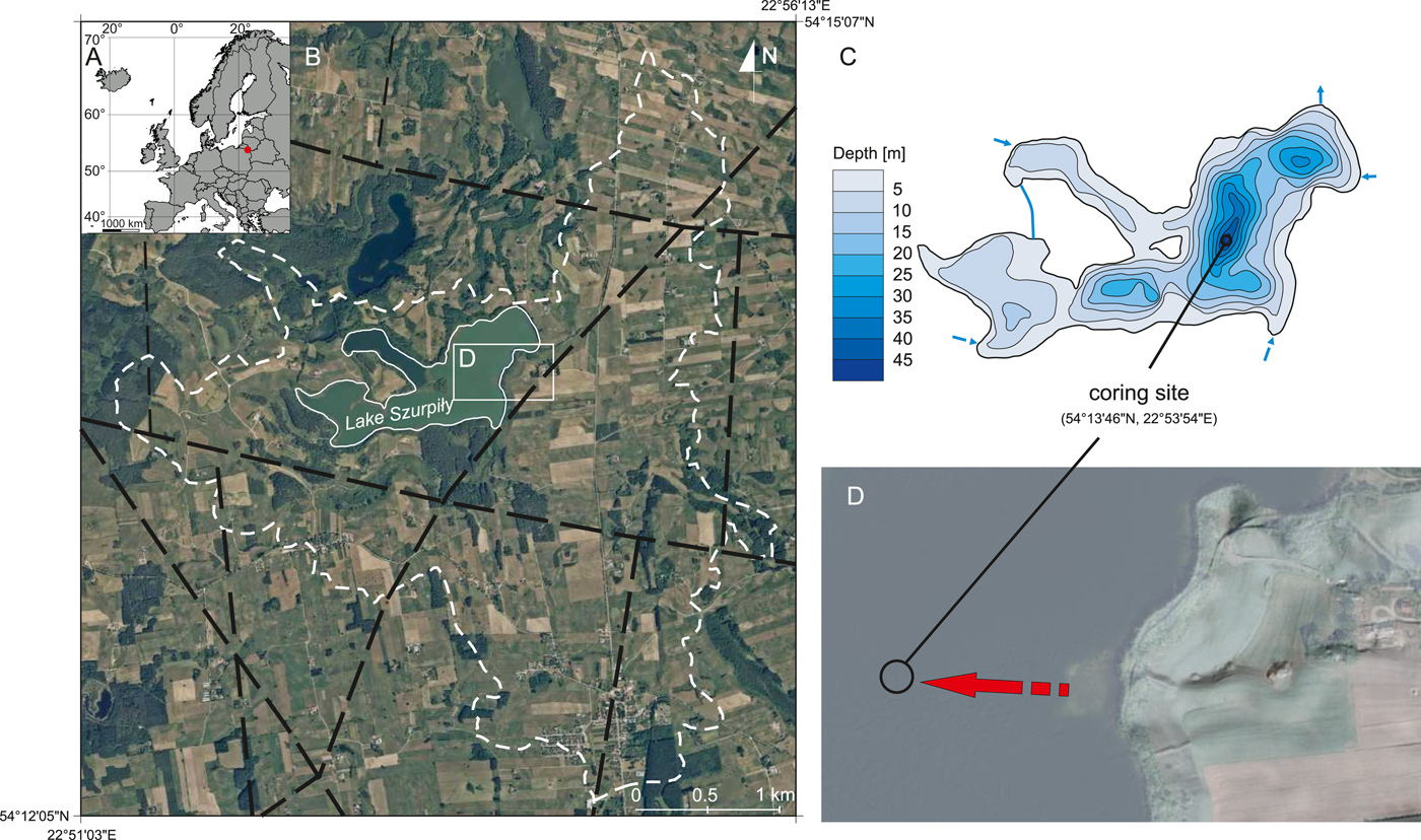
Figure 1. (A) Location of Lake Szurpiły in Europe; (B) orthophoto map (geoportal.gov.pl) with the catchment border (white dashed line) and faults (black dashed lines; Cymerman, Reference Cymerman2014); (C) bathymetry with coring site; (D) enlarged eastern basin of the lake showing a potential source area and direction of MDM type 2 (red arrow). For interpretation of the references to color in this figure legend, the reader is referred to the web version of this article.
The catchment area of Lake Szurpiły (11.14 km2) is dominated by glacial sand and gravel, and till deposited during the Pomeranian phase of the Weichselian glaciation (Ber, Reference Ber2000; Mojski, Reference Mojski2005). The lake basin itself is located in the Szeszupa Depression, which was formed as a consequence of dead ice melting in the late glacial (Smolska, Reference Smolska1996). The ice sheet had already retreated from the Szeszupa Depression between 17.9 and 14.4cal ka BP (Dzierżek and Zreda, Reference Dzierżek and Zreda2007; Weckwerth et al., Reference Weckwerth, Wysota, Piotrowski, Adamczyk, Krawiec and Dąbrowski2019) and, according to pollen stratigraphy, lacustrine sedimentation had begun in the Allerød (Kupryjanowicz, M., unpublished data). Lacustrine sedimentation started at sites investigated nearby during the same period, such as Lake Linówek (3 km to the southwest) at ca. 14 cal ka BP (Gałka et al., Reference Gałka, Tobolski, Zawisza and Goslar2014), Lake Wigry (20 km to the southeast) at ca. 13.8 cal ka BP (Kupryjanowicz, Reference Kupryjanowicz2007), and Lake Kojle (5 km to the north) at ca. 13.5 cal ka BP (Gałka et al., Reference Gałka, Tobolski and Bubak2015). Lake Szurpiły has a small surface area of 0.81 km2 and a well-developed shoreline. The slopes are relatively steep, the littoral zone is narrow, and the profundal has a complex bathymetry. Maximum and mean depths are 46.2 and 10.0 m, respectively. Depending on the season, Lake Szurpiły is fed by two to four inflows and has one outflow to the northeast. The lake is classified as dimictic and eutrophic, with strong hypolimnetic oxygen depletion resulting in anoxic conditions during summer and winter stagnations (Górniak et al., Reference Górniak, Reszczyński, Siwak, Świerubska and Fałtynowicz2007). Morphometric and limnological conditions have favored the deposition and preservation of biogenic varves described by Kinder et al. (Reference Kinder, Tylmann, Enters, Piotrowska, Poreba and Zolitschka2013).
METHODS
Core collection and age–depth model
A pair of adjacent overlapping sediment cores were recovered in September 2007 from the deepest part of Lake Szurpiły using a 60-mm-diameter Uwitec piston-coring system from a floating platform (Fig. 1). A short gravity core provided collection of the undisturbed sediment-water interface. The lengths of individual core sections range from 0.7 to 1.35 m, while the composite profile has a total length of 12.39 m (Figs. 2 and 3). The same core was used in previous publications (i.e., Kinder et al., Reference Kinder, Tylmann, Enters, Piotrowska, Poreba and Zolitschka2013, Reference Kinder, Tylmann, Bubak, Fiłoc, Gąsiorowski, Kupryjanowicz, Mayr, Sauer, Voellering and Zolitschka2019).

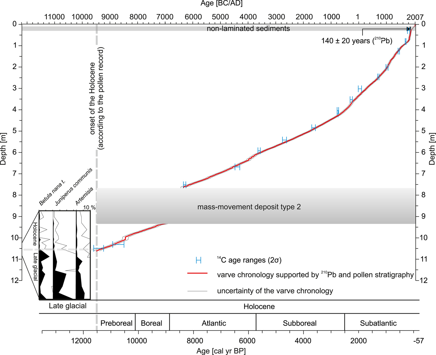
Figure 2. (Color online) Age–depth model from Kinder et al. (Reference Kinder, Tylmann, Enters, Piotrowska, Poreba and Zolitschka2013) based on varve chronology supported by 210 Pb dating in the nonlaminated section and extended to the late glacial using varve counting and pollen stratigraphy and validated by radiocarbon dating. A sharp decrease in selected pollen percentages marks the onset of the Holocene.

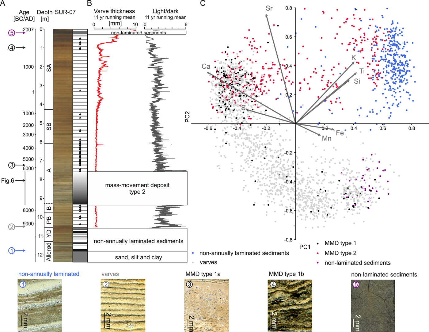
Figure 3. (color online) (A) Composite sediment profile from Lake Szurpiły with examples of sedimentary facies (bottom) and position of the nonlaminated section, mass-movement deposit (MMD) type 1 facies (black triangles), MMD type 2 facies, and non–annually laminated section; (B) varve thickness and light/dark laminae-thickness ratio with 11 yr running mean; (C) scatter plot and biplot of principal component analysis (PCA) based on geochemical data retrieved by X-ray fluorescence scanning. Five groups representing different sedimentary facies were distinguished before PCA.
The age–depth model was described by Kinder et al. (Reference Kinder, Tylmann, Enters, Piotrowska, Poreba and Zolitschka2013) and was extended here to the late glacial using varve counting, radiocarbon, and pollen data (Fig. 2). Varve counting and thickness measurements were conducted with CooRecorder software (Larsson, Reference Larsson2003). For this purpose, we used images obtained by scanning thin sections on a flatbed scanner under polarized light with a resolution of 2400 dpi.
Sedimentary facies
Interpretation of sedimentary facies was based on microscopic investigations of thin sections prepared for the entire sediment record. Laminations and other structures were analyzed with a petrographic microscope for their internal structure and composition. As a result, we distinguished five sedimentary facies of different characteristics and interpreted them in terms of depositional processes. The terminology for laminated or varved facies is based on Zolitschka et al. (Reference Zolitschka, Francus, Ojala and Schimmelmann2015) and for MMDs on Wilhelm et al. (Reference Wilhelm, Nomade, Crouzet, Litty, Sabatier, Belle and Rolland2016).
Laboratory analyses
Continuous down-core X-ray fluorescence (XRF) scans were performed on split cores with the ITRAX XRF core scanner at the University of Bremen. The step size used for measurement was set to 5 mm. In this paper, we present selected results expressed as element intensities normalized by coherent radiation.
Grain-size analyses of selected MMD type 1 facies were carried out with a Mastersizer 2000 laser diffraction granulometer (Malvern Instruments) at the Adam Mickiewicz University in Poznań, and MMD type 2 facies was analyzed using a laser particle-size analyzer (Beckman Coulter LS 200) at the University of Bremen, both with an upper grain-size limit of 2000 μm. The MMD type 1 facies were subsampled at 0.5 to 1 cm intervals, whereas MMD type 2 facies was subsampled according to lithological changes, which resulted in 25 samples distributed across the 170-cm-thick deposit. Sediment samples (1 cm3 in volume) for grain-size analyses were pretreated with 30% H2O2 to remove organic matter (Agrawal et al., Reference Agrawal, McCave, Riley and Syvitski1991; Pansu and Gautheyrou, Reference Pansu and Gautheyrou2006). Three aliquots were taken from each sample, and the final values reported are the arithmetic means of the three measurements.
Data analyses
Statistical analyses were conducted using PAST software v. 3.20 (Hammer et al., Reference Hammer, Harper and Paul Ryan2001). For principal component analysis (PCA), we used the standardized geochemical data set scaled to zero mean and unit variance. Unconstrained clustering was done for selected geochemical data of the MMD type 2 facies using Ward's method and the Euclidean distance (Murtagh and Legendre, Reference Murtagh and Legendre2014). Wavelet analysis was used to identify nonstationary periodicities for varve-thickness data (Hammer and Harper, Reference Hammer and Harper2006). This type of spectral analysis requires interpolated data to avoid half or missing years but provides information about the variability of cyclicities along the time axis, a method more appropriate than Fourier transform, which is limited to stationary signals (Labat, Reference Labat2005). We used Morlet wavelet analysis to distinguish the temporal oscillations of varve thicknesses in three intervals representing approximately Preboreal to Boreal, Atlantic to Subboreal, and Subatlantic time windows. Total varve thicknesses and light/dark laminae-thickness ratios were examined in terms of existing cyclicities. Contoured areas in Figure 4 show confidence levels above 95% and the cone of influence delimits regions where edge effects become important.

Figure 4. (color online) (A) Total varve thickness with fall–winter (dark) and spring–summer laminae (light) (note different time scales depending on the period); (B) wavelet spectra of total varve thickness; and (C) light/dark laminae-thickness ratio divided into three periods (1–3) covering approximately Preboreal–Boreal (1), Atlantic–Subboreal (2), and Subatlantic (3) periods. Contoured areas show confidence levels above 95%. The cone of influence delimits regions where edge effects become important.
RESULTS
Age–depth model
The age–depth model described previously by Kinder et al. (Reference Kinder, Tylmann, Enters, Piotrowska, Poreba and Zolitschka2013) is based on 210Pb dating, varve counting, and 14 radiocarbon ages; reaches a sediment depth of 7.58 m; and covers the last 8410 ± 101 yr. To complete the chronology for the entire analyzed sediment profile, we used additional varve counts, two new radiocarbon ages, and pollen data, which allowed us to extend the age–depth model into the late glacial (Fig. 2). Pollen analyses document that the end of the Younger Dryas was marked by a sharp decline of Betula nana t., as well as Juniperus communis and Artemisia. Thus, the onset of the Holocene (commonly 11,550 cal yr BP, according to Mangerud et al. [Reference Mangerud, Andersen, Berglund and Donner1974]) was established at a depth of 10.54 m. This is confirmed by a radiocarbon age of a leaf fragment found at a sediment depth of 10.45 m that has an age range of 11,620–11,270 cal yr BP (9670–9320 BC). Thus, the floating varve chronology for this section was anchored to the beginning of the Holocene and verified by a second radiocarbon date of fragments of wood and a grass shoot at a sediment depth of 10.30 m (11,090–10,510 cal yr BP; 9140–8560 BC), which is also consistent with the varve chronology. The final age–depth model shows a hiatus of ca. 660 yr related to a thick layer of mostly clastic material at a sediment depth of 9.30–7.58 m.
Sedimentary facies
The bottommost part (12.39–11.87 m) of the sediment profile consists of glacial deposits (sands, silts, and clays) that are not analyzed here. Within the lacustrine sequence, we have distinguished five sedimentary facies (Fig. 3): (1) non–annually laminated sediments, (2) varved sediments, (3) MMD type 1, (4) MMD type 2, and (5) nonlaminated sediments. Varves and MMDs are the main focus of this paper, while only general characteristics are provided for the remaining sedimentary facies.
Non–annually laminated sediments (LS)
The beginning of lacustrine sedimentation of Lake Szurpiły is represented by highly minerogenic and low carbonaceous material. Although this section shows laminations, they are irregular, with no distinguishable annual pattern. Instead, layers of different particle sizes form a rather chaotic structure (Fig. 3). The LS facies covers almost the entire late-glacial section and has a distinct geochemical composition characterized by high K and Ti values (Fig. 3C).
Varved sediments (VS)
Deposition of annually laminated sediments (varves) in Lake Szurpiły started during the transition from the late glacial to the Holocene at 10.60–10.55 m depth (Figs. 2 and 3B). The VS facies was defined as biogenic (organic-carbonaceous) varves (Kinder et al., Reference Kinder, Tylmann, Enters, Piotrowska, Poreba and Zolitschka2013), typically composed of two layers: thicker calcareous spring–summer laminae (light) and fall–winter laminae (dark) consisting mainly of organic detritus. However, in the uppermost part of the Holocene sediment profile, more complex varve structures, such as an additional diatom layer (topmost 0.5 m) or double calcite laminae within one varve (3.9–3.4 m, 400–50 BC) also occur (Kinder et al., Reference Kinder, Tylmann, Enters, Piotrowska, Poreba and Zolitschka2013). Varves cover 63% of the composite sediment profile, and their thicknesses range from <0.1 to 13.7 mm (mean, 0.73 mm), although the majority (80%) do not exceed 1 mm. Geochemically, the VS facies represents a wide compositional range, mainly related to carbonates (Ca, Sr) and redox-sensitive elements (S, Mn, Fe), with low contributions of lithophile elements (K, Ti, Si; Fig. 3C).
Between 9600 ± 110 and 7063 ± 101 BC (10.54–9.30 m), the mean varve thickness (VT) was low (Fig. 4A.1) and relatively stable (mean: 0.44 ± 0.18 mm). During this period, the mean dark lamina thickness remained extremely thin (mean: 0.12 ± 0.08 mm), that is, only ca. 25% of its average thickness. The absolute VT minimum occurred from 7300 ± 103 BC to 7100 ± 101 BC (9.36–9.32 m). After deposition of MMD type 2 facies (i.e., at 7.58–4.08 m), varve sedimentation reestablished (Fig. 4A.2), and varves became thicker (mean: 0.53 ± 0.18 mm), mainly due to dark laminae of increasing thickness. The Subatlantic (4.08–0 m) is characterized by the highest mean values and greatest variability of VT (mean: 1.42 ± 1.05 mm; Fig. 4A.3). In some sections, dark and light laminae had comparable thicknesses (AD 750–1150, 2.40–1.68 m), or dark laminae became dominant (AD 1230–1330 and AD 1500–1650, 1.57–1.37 and 1.11–0.91 m, respectively). A few peaks of increased VT occurred at 400–330 BC (3.90–3.80 m), AD 950–1100 (2.13–1.81 m), around AD 1250 (1.53 m) and AD 1450 (1.20 m), and since AD 1750 (<0.8 m). The thinnest varves were deposited between AD 1550 and AD 1700 (1.04–0.86 m).
Mass-movement deposits—MMD type 1
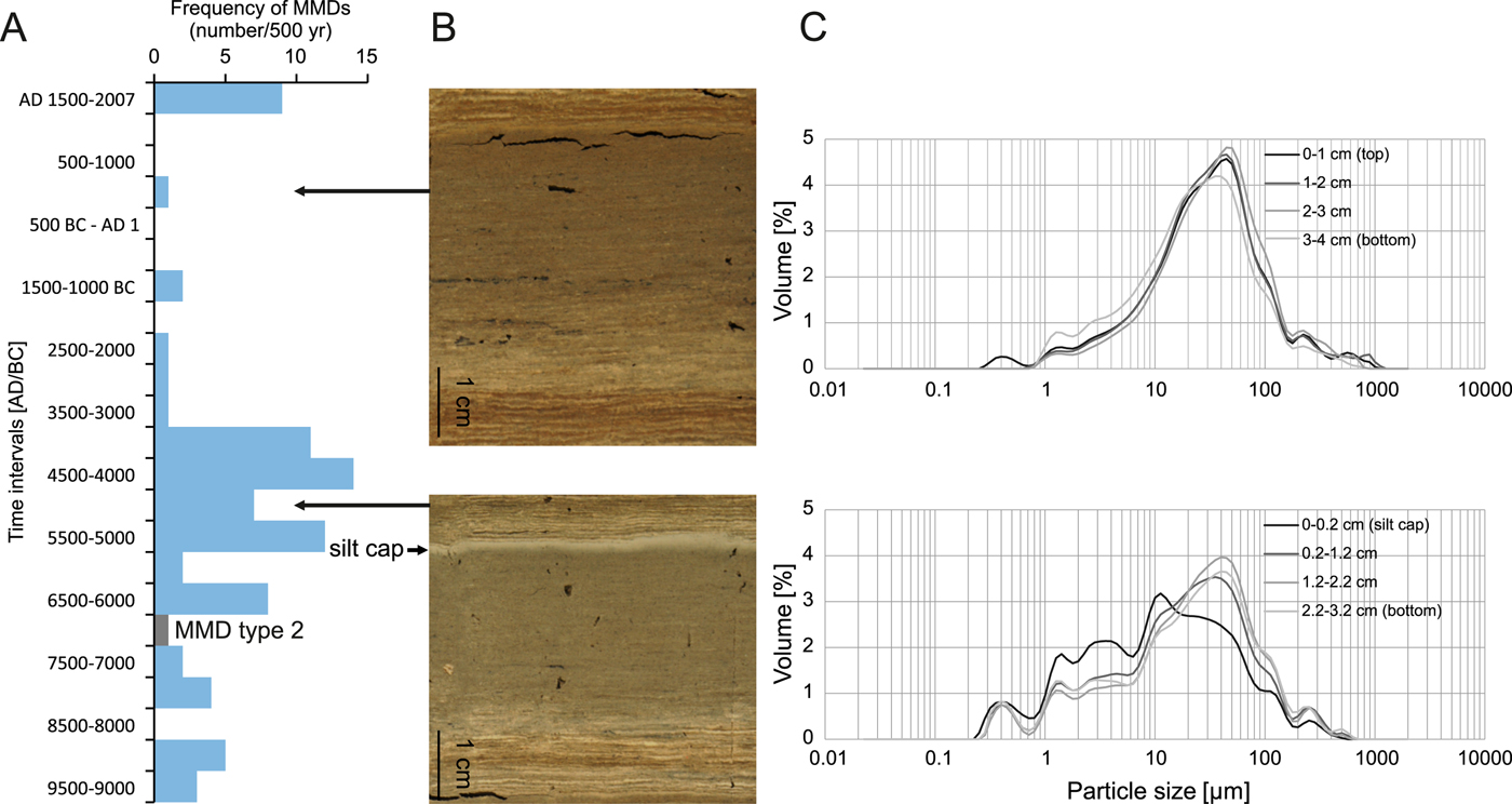
In the Holocene section, as many as 85 layers were identified as MMD type 1 facies. We describe them as subaquatic MMDs that incorporate remobilized lacustrine sediments and are recorded as massive layers (type 1a) or layers of disturbed varves (type 1b) with an overall thickness not exceeding 10 cm. The highest frequency (per 500 yr) of these deposits occurred between 4500 BC and 4000 BC. Most type 1 MMDs have a nonerosive base, but there is evidence of small-scale deformations of the underlying varves in some cases. We found 20 massive layers with silt caps, most of them deposited during the Atlantic period (9.30–6.10 m) and only three during the Preboreal and Boreal (10.54–9.75 m) periods. The results of grain-size analysis of two selected MMD type 1 structures from different periods are presented in Figure 5C. Both have a comparable thickness, consist of silty material, and do not contain a coarse-grained base, although only the second is topped with a clear medium silt cap typical of turbidites or flood layers (Fig. 5B and C).

Figure 5. (color online) (A) Frequency of mass-movement deposits (MMDs) in 500 yr intervals; (B) MMDs selected from different periods; and (C) MMD particle size measurements in 1 cm intervals. If a medium silt cap occurred, it was analyzed separately.
Geochemically, sediments of MMD type 1 facies have a composition similar to that of varves and do not form a separate cluster (Fig. 3C), which indicates remobilization of lacustrine material within the lake basin rather than the input of allochthonous material from the catchment.
Mass-movement deposits—MMD type 2
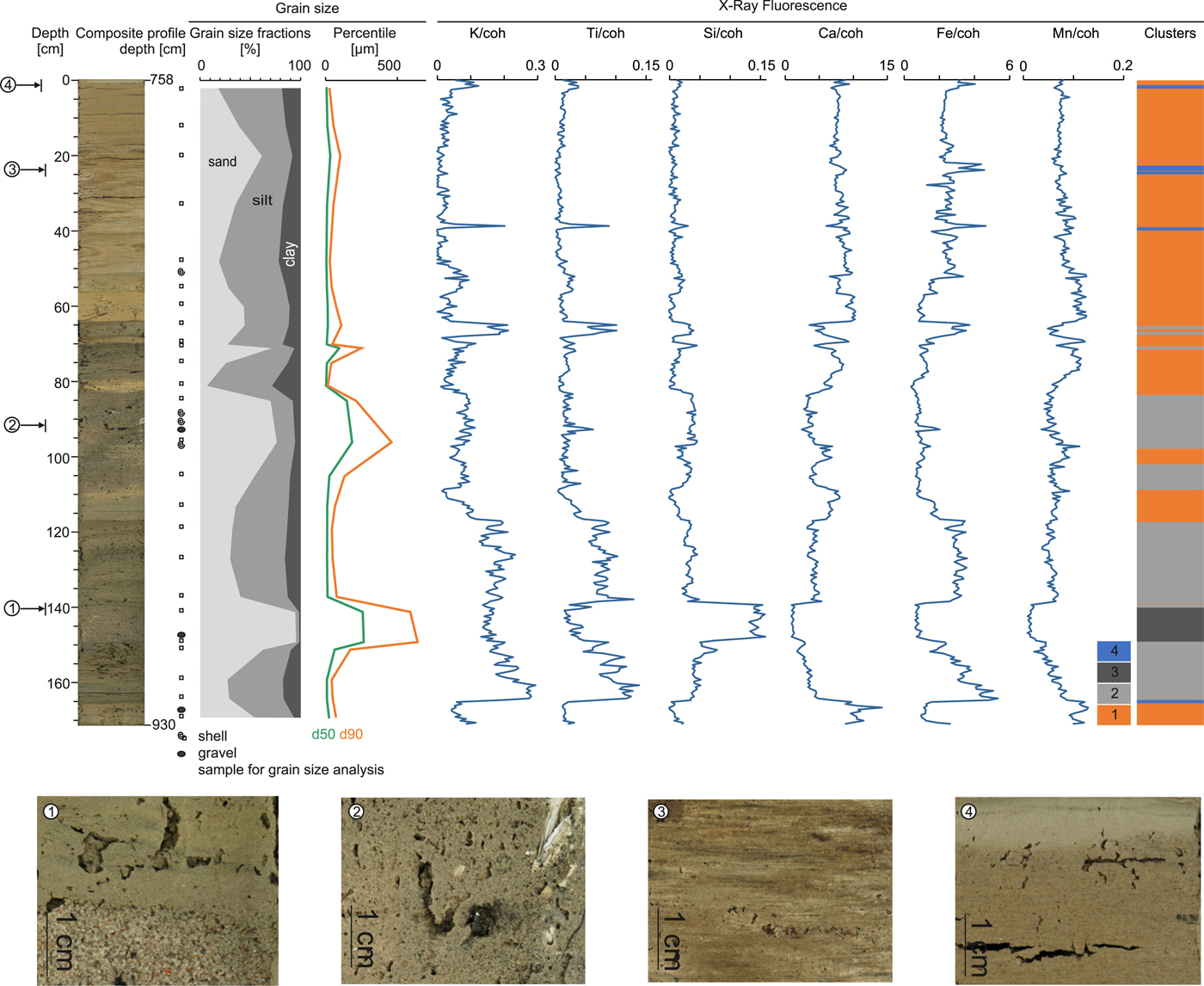
The MMD type 2 facies consisting of mixed clastic and lacustrine material was identified at sediment depth 9.30–7.58 m. In general, this facies is highly differentiated and composed of several layers of variable composition (Fig. 6). The sequence is composed of clay to sand, and there are few gravels and shells, mostly in the sandy layers. The uppermost 20 cm of MMD type 2 has a clear gradation and a silt cap. Mean particle size of analyzed samples is in the range of 3.7–233.8 μm (median: 3.6–266 μm), although only two sand layers are represented by a mean particle size larger than 100 μm. From the age–depth model (Fig. 2), we conclude that deposition of this facies destroyed ca. 660 varves and caused a hiatus in the Atlantic between 7060 and 6400 ± 100 BC. Considering that the mean VT in the underlying sediments is 0.5 mm, a 33-cm-thick layer of sediment would have been remobilized into the water column and probably redeposited within MMD type 2.

Figure 6. (color online) Mass-movement deposit type 2 with enlarged fragments (bottom), generalized grain-size distribution, selected X-ray fluorescence data normalized by coherent radiation, and clustering results documenting this deposit as a multistep event. Geochemical clusters are explained in the text.
Apart from this sedimentological complexity and the dominance of minerogenic material, XRF results confirmed the geochemical heterogeneity (Figs. 2 and 6). The bottom 5 cm are disturbed lacustrine carbonate sediments with low levels of lithophilic elements (K and Ti), followed by highly minerogenic material visible as sharp increases in K and Ti, as well as Si and Fe. A similar situation is observed above 897 cm, at 822–828 and 797–798 cm, and for the topmost 2 cm (Fig. 6). The section between 910 and 897 cm is characterized by the highest Si values and a decrease of other elements, with the lowest levels of Ca and Mn found here. Such geochemical fluctuations indicate rapid changes in the source of the mass-movement material.
Unconstrained clustering of selected geochemical elements resulted in four clusters, indicating different geochemical characteristics within the MMD type 2 facies (Fig. 6). Cluster 1 represents remobilized autochthonous lacustrine sediment with generally low levels of K, Ti, and Si and considerably higher Ca, Fe, and Mn content. Cluster 2 covers most of the lower half of MMD type 2 and is composed of highly minerogenic sediment with substantial input of allochthonous material (high K and Ti accompanied by low Ca). Cluster 3 is a sandy layer dominated by Si, whereas cluster 4 occurs rarely and correlates with the highest Fe peaks related to slightly higher organic matter contents.
Nonlaminated sediments (NL)
The section between 0.28 and 0.08 m consists of almost exclusively organic material of the massive structure. The presence of the NL facies was confirmed with multiple, short gravity cores. Despite the absence of visible varves or laminations, this section represents undisturbed sedimentation, as shown by 210Pb dating (Kinder et al., Reference Kinder, Tylmann, Enters, Piotrowska, Poreba and Zolitschka2013). The geochemical composition of the NL does not reveal any increase in minerogenic inputs, but rather reflects changes in oxygen conditions at the lake bottom (correlation to Mn and Fe) (Fig. 3C).
Cyclicities in varves
Wavelet analyses were carried out to check for cyclicities in VT within the VS facies for the three time windows covering approximately: the Preboreal–Boreal (10.54–9.30 m), the Atlantic–Subboreal (7.58–4.08 m), and the Subatlantic (4.08–0 m) periods (Fig. 4B and C). These time windows were selected to distinguish the sediments deposited (1) before MMD type 2; (2) during the Middle Holocene, without significant land-use changes; and (3) during the Late Holocene, characterized by strong and increasing human impact. Generally, cyclicities are more distinct for the Preboreal–Subboreal (10.54–4.08 m), whereas they are less pronounced during the youngest Holocene (4.08–0 m). Total VT and light/dark lamina ratio reveal 88 yr, 208 yr, and even shorter (11 and 22 yr) cycles. The signal of the 208 yr cycle is not continuous, but it is the most distinct around 9000 BC and between 8500 BC and 7300 BC in total VT and light/dark lamina ratio. During the Middle and Late Holocene, the signal becomes patchy (strongest for 5000–4000 BC and 3500–2000 BC) (Fig. 4C.2). The 88 yr cycle is detectable between 4700 and 4500 BC and 3100 and 2900 BC in total VT, while it is more frequent in light/dark lamina ratio (9500–9300 BC, 9100–9000 BC, around 5500 BC, 5000 BC, 4500 BC, 3800–3600 BC, 2500–2200 BC, and 1500–1400 BC). The strongest signal of the 22 yr cycle (double sunspot) is visible in light/dark lamina ratio around 9400 BC, 8400–8100 BC, and 7300 BC (Fig. 4C.1), as well as in short but more frequent time windows of the Atlantic–Subboreal (Fig. 4C.2) and around AD 1500 (Fig. 4C.3). The 11 yr sunspot cycle has the most visible signal within two minima in VT at around 7300 BC and AD 1500.
DISCUSSION
Sedimentary processes and facies
Diverse processes of deposition dominated during different periods of Lake Szurpiły's evolution. The late-glacial laminated sediments (LS) are characterized by frequent deposition of minerogenic layers that interrupted autochthonous lacustrine sedimentation such that an annual depositional pattern characteristic for varves was not established (Fig. 3). We infer that poor vegetation cover, young postglacial landforms, and progressive degradation of permafrost enabled increased minerogenic input under generally cold climatic conditions. Moreover, steep slopes of the central lake basin favored slumping. Therefore, this facies indicates highly dynamic conditions of sedimentation in a young postglacial landscape.
Rhythmic annual sedimentation leading to the deposition of facies VS in Lake Szurpiły was established during the transition from the late glacial to the Holocene. The onset of varved sedimentation was delayed compared with other varved records located in central northern Poland; for example, Lake Gościąż (~11,000 BC) (Ralska-Jasiewiczowa et al., Reference Ralska-Jasiewiczowa, Goslar, Madeyska and Starkel1998) or paleo-Lake Trzechowskie (~11,000 BC) (Słowiński et al., Reference Słowiński, Zawiska, Ott, Noryśkiewicz, Plessen, Apolinarska and Rzodkiewicz2017). This reflects differences in climatic conditions after the Weichselian glaciation, in particular, a later warming in northeastern Poland. Despite minor differences in varve structure and high variability of VT, the overall mechanism of varve formation was stable over time. All varves identified in the sediment profile are biogenic (calcite) varves that form as a result of seasonal variability of biochemical processes in the water column and related calcite precipitation during warm seasons (Zolitschka et al., Reference Zolitschka, Francus, Ojala and Schimmelmann2015). The white spring/summer lamina is composed almost exclusively of autochthonous calcite crystals, while the dark fall/winter lamina consists mainly of organic remains and clastic material.
Despite a general stabilization of environmental conditions during the Early Holocene, there were still periods of increased sedimentary dynamics that resulted in mass-movement deposits reaching the deepest part of the lake. Heterogeneous distribution of these sedimentary structures along the profile shows that the Atlantic was characterized by the most frequent deposition of MMD type 1 facies (Figs. 2 and 7A). MMD type 1a, consisting of coarse silt with medium silt caps, might represent small turbidites. Even though the study site is a considerably small lake relative to other sites where turbidites were identified in sediments (e.g., Sturm and Matter, Reference Sturm, Matter, Matter and Tucker1978; Osleger et al., Reference Osleger, Heyvaert, Stoner and Verosub2009; Moernaut et al., Reference Moernaut, Van Daele, Heirman, Fontijn, Strasser, Pino, Urrutia and De Batist2014), similar structures were described in Meerfelder Maar (surface area 0.25 km2, maximum depth 18 m) by Drohmann and Negendank (Reference Drohmann and Negendank1993) or in alpine Lake Bramant, which had similar basin morphology (surface area 0.14 km2, maximum depth 38 m), by Guyard et al. (Reference Guyard, Chapron, St-Onge, Anselmetti, Arnaud, Magand, Francus and Mélières2007). The geochemical composition of MMD type 1a is very similar to VS, which indicates that this facies is not related to clastic material of terrestrial origin. Also MMD type 1b facies is characterized by layers of disturbed varves, which indicate redeposition of lacustrine sediments within the lake basin, rather than allochthonous input. Thus, remobilization of lacustrine sediments originally deposited in the littoral zone and/or on the slopes caused deposition of MMD type 1 facies in the deepest part of the lake.

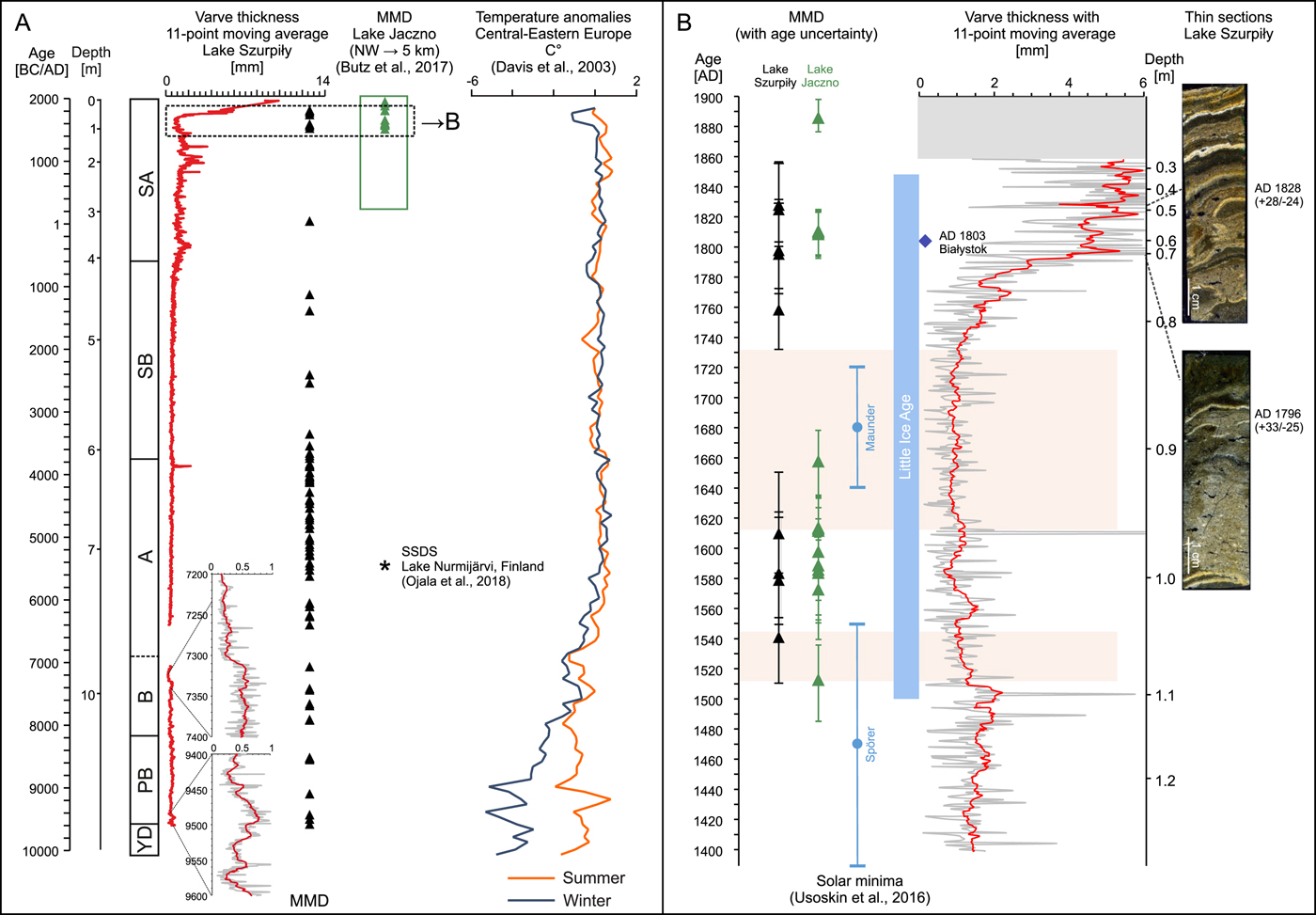
Figure 7. (A) Comparison of the Lake Szurpiły sediment record with mass-movement deposits (MMDs) in Lake Jaczno (Butz et al., Reference Butz, Grosjean, Goslar and Tylmann2017), soft-sediment deformations in Finland (Ojala et al., Reference Ojala, Mattila, Virtasalo, Kuva and Luoto2018), and reconstructions of temperature anomalies for Central–Eastern Europe (Davis et al., Reference Davis, Brewer, Stevenson, Guiot, Allen, Almqvist-Jacobson and Ammann2003); (B) varve thicknesses and MMDs in Lake Szurpiły and Lake Jaczno between AD 1400 and AD 1900 together with solar minima (Usoskin et al., Reference Usoskin, Gallet, Lopes, Kovaltsov and Hulot2016) and the LIA. The blue diamond indicates the earthquake documented for Białystok in northeastern Poland. Two longer intervals of very thin varves are highlighted by orange shading. Thin sections represent examples of MMDs and disturbed varves of Lake Szurpiły. For interpretation of the references to color in this figure legend, the reader is referred to the web version of this article.
Causal rules for these small-scale mass movements are always difficult to determine, because slumping is often initiated randomly by overloading and oversteepening of the slope (Schnellmann et al., Reference Schnellmann, Anselmetti, Giardini, McKenzie and Ward2002). However, distribution of these sedimentary structures along the profile—with the highest frequency between 5500 BC and 3500 BC (Fig. 5)—suggests that the most suitable conditions for mass movements occurred during the Atlantic. The distribution could have been related to climatic conditions, for example, shorter ice cover (mild winters) and thus more intense spring and fall circulation of the water column or stronger winds during the ice-free season causing higher wave action. Higher water-column dynamics might have led to more frequent replacements of loose sediments along the slopes as small-scale turbidites. Potentially, lake-level fluctuations (i.e., lower water level) might also have caused remobilization of material deposited on subaquatic slopes, moving it toward the deepest part of the lake basin.
Another explanation of frequent mass movements in such a small lake would be seismic activity. Even though seismic hazards for northeastern Poland—located on the East European Precambrian platform—are considered low, some historical earthquakes have occurred in this region (Guterch, Reference Guterch2009). For example, the earthquake of 2004 in Kaliningrad (Russia) also caused damage in northeastern Poland (Gregersen et al., Reference Gregersen, Wiejacz, Debski, Domanski, Assinovskaya, Guterch and Mäntyniemi2007). We compared dates of some historical earthquakes with sediment structures down-core, and we suggest that the magnitude 4 earthquake observed in Białystok (approx. 120 km to the south) on January 8, 1803, could have deformed varves or provoked subaquatic mass movements in Lake Szurpiły (Fig. 7B). According to Jibson (Reference Jibson1996), a magnitude 5 earthquake might be sufficient to trigger subaqueous landslides, whereas a magnitude 6 earthquake would be needed to cause a landslide 100 km from the epicenter. Because the location of the epicenter for this earthquake could have been located north of Białystok and, thus closer to Lake Szurpiły, it seems possible that it might have been the cause for the sediment deformations observed. Moreover, an increased frequency of MMD type 1 in Lake Szurpiły during the Atlantic (Fig. 7A) coincides with seismic deformations observed in varves from Fennoscandia at 5450 BC (Ojala et al., Reference Ojala, Mattila, Virtasalo, Kuva and Luoto2018). A similar example of small, although alpine, lakes recording earthquakes has been presented by Wilhelm et al. (Reference Wilhelm, Nomade, Crouzet, Litty, Sabatier, Belle and Rolland2016).
MMD type 2 at 6400 ± 100 BC has an erosive character and is of different origin. A considerable erosional loss of ca. 660 varves is documented by the age–depth model (Fig. 2). A hiatus of this size (the thickness of MMD type 2 reaching 170 cm) and the variability of material involved (clastic particles of different sizes, lacustrine carbonate sediment) suggest highly dynamic processes responsible for the deposition of this facies. Lake-basin bathymetry and the surrounding landforms suggest a slide from the east into the central lake basin. The narrow and V-shaped valley on the eastern lakeshore (Fig. 1D) was probably cut as a result of increased erosion during the late glacial or early Holocene, and the eroded material was deposited in the lake basin, forming a subaqueous fan that is visible in the orthophoto map (Fig. 1D). In our interpretation, at 6400 ± 100 BC, the slopes of this fan became unstable, leading to this enormous mass movement. This could have been triggered by climatic events (e.g., rapid erosion after heavy rains), slope overloading, or an earthquake. The sedimentary sequence of MMD type 2 documented in Figure 6 indicates a stepwise erosion and deposition: (1) erosion and deformation of underlying VS, (2) a rapid deposition of clastic material (including shells from the littoral zone) mixed with lacustrine material, and (3) redeposition of the previously eroded VS on top of the clastic sequence in the form of a turbidite, such as that described by Wilhelm et al. (Reference Wilhelm, Nomade, Crouzet, Litty, Sabatier, Belle and Rolland2016). In consequence, the MMD type 2 facies records a multistage process of subaquatic mass movements containing both allochthonous and autochthonous material (Figs. 1D, 3, and 6).
Permafrost degradation, subsidence, and transformations of ground-water circulation in the catchment appear to be possible alternative causes of initiating an MMD in the form of a thaw slump (Pánek, Reference Pánek2019). The probable direction of the transport is indicated in Figure 1D. It is confirmed that permafrost persisted in northeastern Poland until ca. 2000 BC, and its relicts are detectable even now (Šafanda et al., Reference Šafanda, Szewczyk and Majorowicz2004; Honczaruk and Śliwiński, Reference Honczaruk and Śliwiński2011). There is a clear coincidence in the timing of permafrost degradation in the Sokolica/Spurgle site (ca. 120 km to the west from Lake Szurpiły) described by Dobrowolski et al. (Reference Dobrowolski, Mazurek, Osadowski, Alexandrowicz, Pidek, Pazdur, Piotrowska, Drzymulska and Urban2019) and MMD type 2. Potentially, very late permafrost degradation and unblocking of horizontal flows of ground water could have triggered MMD type 2. Lake Szurpiły is located in the Szeszupa Depression and on the Anorthosite Intrusion, which could have favored the prolonged existence and thawing of permafrost (Šafanda et al., Reference Šafanda, Szewczyk and Majorowicz2004). This is supported by the lowest heat flow value (38 mWm−2) in this part of Poland (Szewczyk and Gientka, Reference Szewczyk and Gientka2009). Progressive warming could have enhanced the melting and activated the ground-water circulation, leading to a sudden loss of slope stability and triggering a thaw slump (Karlsson et al., Reference Karlsson, Lyon and Destouni2012; Séjourné et al., Reference Séjourné, Costard, Fedorov, Gargani, Skorve, Massé and Mège2015; Kanevskiy et al., Reference Kanevskiy, Shur, Jorgenson, Brown, Moskalenko, Brown, Walker, Raynolds and Buchhorn2017; Filbee-Dexter et al., Reference Filbee-Dexter, Wernberg, Fredriksen, Norderhaug and Pedersen2019).
Although it is difficult to provide unambiguous evidence supporting earthquakes as triggers for the deposition of MMD type 2 sediments, mass movements originating from earthquakes are found in different lakes (Juschus et al., Reference Juschus, Melles, Gebhardt and Niessen2009). Traces of Holocene earthquakes have been recognized in several European sedimentary records (e.g., Monecke et al., Reference Monecke, Anselmetti, Becker, Schnellmann, Sturm and Giardini2006; Mörner, Reference Mörner2011; Ojala et al., Reference Ojala, Mattila, Virtasalo, Kuva and Luoto2018). The postglacial uplift of Scandinavia is the main reason for seismic events, mainly during the last 9000 yr (Gregersen, Reference Gregersen2002). Soft-sediment deformation structures caused by a glacio-isostatic rebound in northwest Poland were described by Van Loon and Pisarska-Jamroży (Reference Van Loon and Pisarska-Jamroży2014). Moreover, faults in varved clays were also observed in the Skaliska Basin, 60 km to the west of Lake Szurpiły (Pochocka-Szwarc, Reference Pochocka-Szwarc2010). Therefore, glacio-isostatic rebound and related seismic events could have triggered mass movements along the slopes. Such an origin is supported by Lake Szurpiły's proximity to faults in the bedrock (Fig. 1B).
Finally, nonlaminated sediments do not reveal depositional disturbances. We assume that disappearance of varves between AD 1858 ± 20 and AD 1998 is related to better oxygenation of the hypolimnion, which does not favor the formation and/or preservation of varves (Kinder et al., Reference Kinder, Tylmann, Bubak, Fiłoc, Gąsiorowski, Kupryjanowicz, Mayr, Sauer, Voellering and Zolitschka2019). On the other hand, increased lacustrine productivity with stronger anoxia accompanied by stabilized conditions in the catchment could have triggered the reappearance of varves in the topmost section of the core. Eutrophication as a key factor for the deposition of VS has also been reported for other sites (e.g., Baldegersee, Sacrower See, Lake Belau, and Lake Murten) (Lotter et al., Reference Lotter, Sturm, Teranes and Wehrli1997; Lüder et al., Reference Lüder, Kirchner, Lücke and Zolitschka2006; Dreibrodt and Wiethold, Reference Dreibrodt and Wiethold2015; Haas et al., Reference Haas, Baumann, Castella, Haghipour, Reusch, Strasser, Eglinton and Dubois2019).
Paleoclimatic signals in VS
Lake-basin morphology and climatic seasonality were the key factors that favored the deposition and preservation of VS in the deepest part of Lake Szurpiły since the onset of the Holocene. A continuous series of VT measurements enables the tracking of trends and detection of potential periodicities. Also, in Lake Szurpiły, the VT variability seems to reflect some of the solar minima, as well as cyclicities related to solar activity.
From the Early Holocene to ca. 1000 BC, the VT variability does not show any significant shifts and long-term trends (Fig. 3). This relatively stable VT was driven mainly by natural factors, as there were no significant human activities in the catchment (Kinder et al., Reference Kinder, Tylmann, Bubak, Fiłoc, Gąsiorowski, Kupryjanowicz, Mayr, Sauer, Voellering and Zolitschka2019). In contrast, during the last 3000 yr, human impact has increasingly played a major role (Kinder et al., Reference Kinder, Tylmann, Bubak, Fiłoc, Gąsiorowski, Kupryjanowicz, Mayr, Sauer, Voellering and Zolitschka2019). The most distinct minima in VT (between AD 1550 and AD 1700, 1.04–0.86 m) coincide with the Little Ice Age (LIA) climate cooling (Figs. 4 and 7). The decrease of VT at the beginning of the sixteenth century corresponds well with the Spörer minimum (Usoskin et al., Reference Usoskin, Gallet, Lopes, Kovaltsov and Hulot2016), and the most distinct minimum in VT (between AD 1620 and AD 1740, 0.94–0.82 m) coincides with the Maunder minimum (Fig. 7B). The persistence of thin varves reflects climatic and catchment conditions during the LIA, which is described as a humid and cold period in Europe (Mann et al., Reference Mann, Zhang, Rutherford, Bradley, Hughes, Shindell, Ammann, Faluvegi and Ni2009; Büntgen et al., Reference Büntgen, Kyncl, Ginzler, Jacks, Esper, Tegel, Heussner and Kyncl2013), with distinctly colder winters in Central–Eastern Europe and the lowest temperatures occurring around AD 1700 (Davis et al., Reference Davis, Brewer, Stevenson, Guiot, Allen, Almqvist-Jacobson and Ammann2003; Luoto, Reference Luoto2013). Reconstruction of winter severity in northeastern Poland based on chrysophyte cysts also indicates colder climatic conditions at that time (Hernández-Almeida et al., Reference Hernández-Almeida, Grosjean, Przybylak and Tylmann2015). However, the minimum was also interpreted as the result of limited terrestrial input from the catchment due to stabilized soils and more cattle breeding instead of soil cultivation (Kinder et al., Reference Kinder, Tylmann, Bubak, Fiłoc, Gąsiorowski, Kupryjanowicz, Mayr, Sauer, Voellering and Zolitschka2019). Both reasons could contribute to the observed VT variability, because changes in agricultural practices might have been related to severe climatic conditions. Similarly, lower VT around AD 1700 accompanied by a temporal decrease in cultivated plants in favor of grassland was recorded for Lake Żabińskie in the Masurian lake district (Bonk et al., Reference Bonk, Kinder, Enters, Grosjean, Meyer-Jacob and Tylmann2016), and the lowest mass accumulation rates at Lake Jaczno during AD 1600–1670 were determined by Butz et al. (Reference Butz, Grosjean, Goslar and Tylmann2017). This underlines the regional character of observed changes.
Periodicities in VT reveal solar cycles recorded during the early and middle Holocene (Fig. 4B.1–B.2). The most prominent VT oscillations resemble the Gleissberg cycle (88 yr) and the Suess cycle (208 yr) (Peristykh and Damon, Reference Peristykh and Damon2003). However, these multiple shorter cycles might be a side effect of wavelet analyses (Brauer et al., Reference Brauer, Mangili, Moscariello and Witt2008). Interestingly, the 22 and 11 yr sunspot (Schwabe) cycles are visible in the light/dark laminae-thickness ratio around 7300 BC (Fig. 4.C1) and during the LIA (Fig. 4C.3). Nonetheless, those cycles cannot be interpreted unambiguously in other parts of the composite profile. It is worth noting that the signal can be weakened due to uncertainties of the age–depth model or interpolation of data points required for wavelet analysis. Also, a link between solar activity and varve properties is still under discussion (Vos et al., Reference Vos, Sanchez, Zolitschka, Brauer and Negendank1997, Reference Vos, Brüchman, Lücke, Negendank, Schleser, Zolitschka, Fischer, Kumke, Lohmann, Flöser, Miller, von Storch and Negendank2004; Ojala and Alenius, Reference Ojala and Alenius2005; Haltia-Hovi et al., Reference Haltia-Hovi, Saarinen and Kukkonen2007; Brauer et al., Reference Brauer, Mangili, Moscariello and Witt2008; Czymzik et al., Reference Czymzik, Dreibrodt, Feeser, Adolphi and Brauer2016). While there seems to be a clear relationship for lakes dominated by allochthonous input (clastic varves), it is difficult to explain a process that significantly drives decadal-scale VT variability for biogenic varves. Most likely, changes in solar irradiance have conditioned fluctuations of primary productivity and lacustrine deposition (Livingstone and Hajdas, Reference Livingstone and Hajdas2001; Bradbury et al., Reference Bradbury, Cumming and Laird2002). Despite these problems with direct interpretation, it is evident that the detected cyclicities disappear in the late Holocene (Fig. 4), possibly linked to increasing human impact, which drove major changes in the lake trophic status and related shifts in sedimentation rates during that time.
CONCLUSIONS
In this study, we analyzed the sedimentological and geochemical variability of the sediment record from Lake Szurpiły to understand the processes leading to mass-movement deposition and to detect paleoclimatic signals. The varve record with inserted MMDs allows us to investigate sedimentation dynamics since the late glacial.
The first stage of lacustrine sedimentation during the late glacial suggests conditions with enhanced runoff due to poor vegetation cover and thawing of permafrost in the catchment shortly after the retreat of the Scandinavian Ice Sheet. Stable deposition of VS started with the onset of the Holocene and was then frequently interrupted by mass-movement deposition. Clustering of MMD type 1 in the Atlantic indicates climatic conditions that favored destabilization of sedimentary processes (e.g., shorter ice cover, more intense spring and fall circulation of the water column, and stronger winds during ice-free seasons causing higher wave action). Another explanation of frequent MMD type 1 deposition would be seismic activity. MMD type 2 at 6400 ± 100 BC consists of both auto- and allochthonous material, indicating a complex origin. Most probably, slopes of a subaqueous fan at the eastern part of the lake became unstable due to rapid climatic events or an earthquake and led to a mass movement followed by erosion and deformation of underlying VS, rapid deposition of clastic material, and redeposition of the previously eroded VS. However, very late thawing of permafrost followed by unblocking of ascending ground water as a trigger for slope instability and a mass movement cannot be excluded. Nonlaminated sediments between AD 1858 ± 20 and AD 1998 indicate weaker oxygen depletion without varve formation and/or lacking preservation of varves at the lake bottom.
The multimillennial VT record from Lake Szurpiły enables the detection of paleoclimatic signals. Decreases in VT correspond to the Spörer and Maunder solar minima and reflect climatic conditions with reduced human impact during the LIA. Solar cycles, such as the Gleissberg cycle (88 yr) and Suess cycle (208 yr) are seen in VT before 850 BC, when anthropogenic influence was limited. The 22 and 11 yr sunspot cycles are detectable by light/dark laminae-thickness ratios (e.g., around 7300 BC and during the LIA), demonstrating the influence of solar irradiance on primary productivity and hence on VT. These signals should be interpreted with caution in light of possible weakening due to human activities, chronological uncertainties, and interpolation of data points for statistical analyses.
The varves and MMDs of Lake Szurpiły record complex depositional events and provide valuable data for past sediment dynamics in the European lowlands of northeastern Poland. Our results show that even in a relatively small lake located in a seismically inactive region, sedimentary structures record different depositional processes that can be interpreted in a broader context.
ACKNOWLEDGMENTS
This study was supported by the Polish Ministry of Science and Higher Education grant to MK (N N306 009337) and by the University of Gdansk (538-G110-0444-1). It is a contribution to the bilateral scientific program Northern Polish Lake Research (NORPOLAR), a Polish–German research initiative carried out between the Universities of Bremen and Gdańsk, and was funded by the German Research Foundation and the Polish Ministry of Science and Higher Education. We thank Dirk Enters, Anna Poraj-Górska, and Maurycy Żarczyński for performing grain-size analyses of the MMD type 2 and the Suwałki Landscape Park for cooperation.