1. Introduction
Myanmar west of the Salween River (Fig. 1) is of considerable geological interest because of its position between the Indus–Yarlung suture zone and Lhasa block in Tibet, and the active Sunda arc system and western part of the Shan Plateau, and because of its varied and valuable mineral deposits, many of which were in production prior to World War 1. Since the early 1970s, great progress has been made in defining a Shan–Thai, Sibumasu (Fig. 1) or Sibuma Block occupying most of the Shan Plateau in eastern Myanmar, and in relating the post-Early Cretaceous Popa–Loimye arc (e.g. Mitchell & McKerrow, Reference Mitchell and McKerrow1975; Metcalfe, Reference Metcalfe1984; Barber et al. Reference Barber, Crow, Barber, Zaw and Crow2017; Cai et al. Reference Cai, Ding and Yao2020) and its mineralization (Goossens, Reference Goossens1978; United Nations, 1978; Gardiner et al. Reference Gardiner, Robb, Morley, Searle, Cawood, Whitehouse, Kirkland and Roberts2016, Reference Gardiner, Searle, Morley, Robb, Whitehouse, Roberts, Kirkland and Spencer2018; Khin Zaw, Reference Khin Zaw, Barber, Zaw and Crow2017; Mitchell, Reference Mitchell2017; Ye Myint Swe et al. Reference Barber, Zaw and Crow2017; Aung Zaw Myint, pers. comm., 2020) to subduction of the Indian Ocean or Neo-Tethys (Li et al. Reference Li, Fan, Zhang, Peng, Sun, Ding and Cai2020) beneath Myanmar. However, despite many proposals as emphasized by Racey (Reference Racey and Mitchell2017), there is no consensus on the earlier Mesozoic tectonic evolution of Myanmar west of the Salween, and few interpretations discuss the Neo-Tethys subduction zone required to generate the Lower Cretaceous Mondaung magmatic arc in the Shan Scarps.
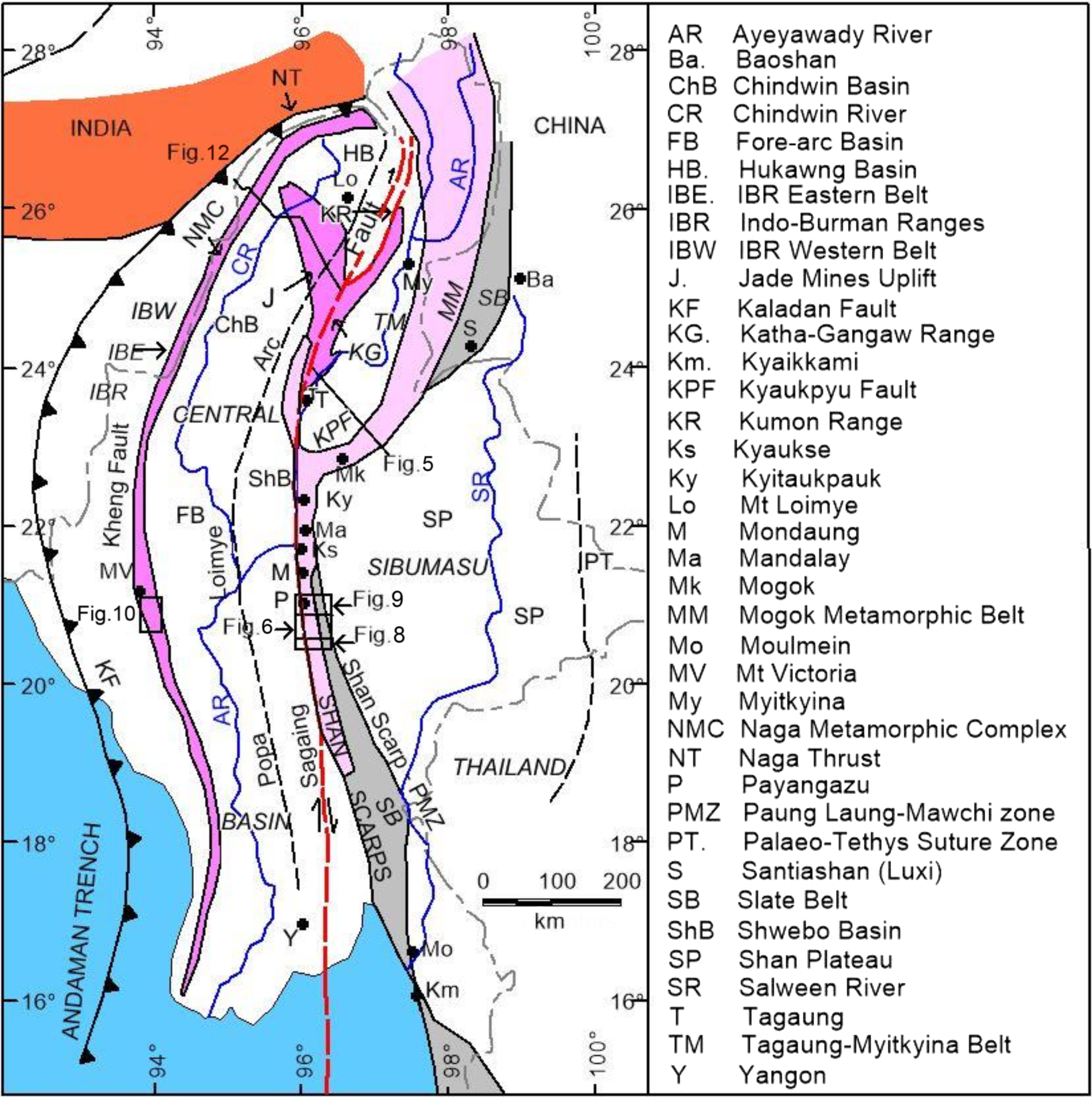
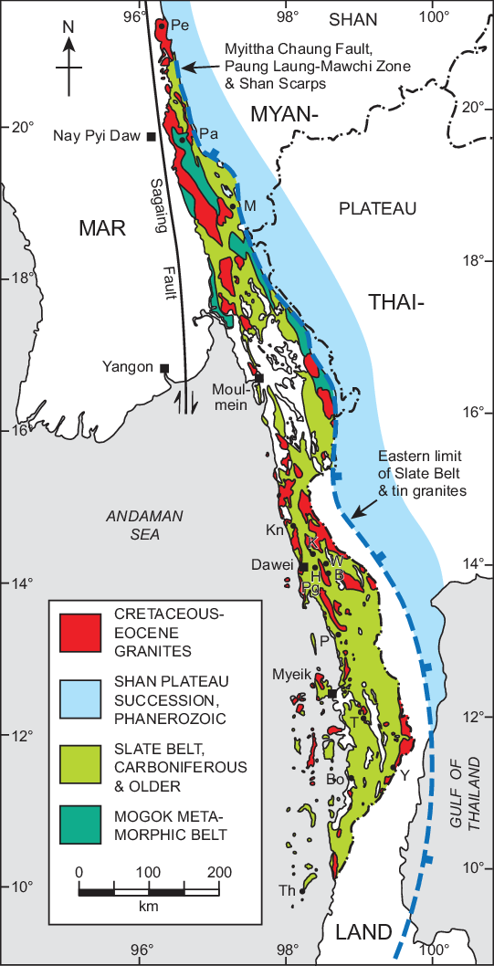
Fig. 1. Sketch map of Myanmar north of 17° N showing Sagaing Fault, structural units to east and west, major faults and places referred to in text. The Victoria–Katha Block is highlighted in purple.
Probably the earliest attempts to identify small continental blocks and suture zones in or near Myanmar were those of Hutchison (Reference Hutchison, Gobbett and Hutchison1973) in recognizing in eastern Malaya a Permian magmatic arc and Stauffer (Reference Stauffer1974) in proposing a suture zone along the Bentong–Raub line at the eastern margin of his West Malaya Block. Stauffer continued the Bentong-Raub line northwards through Thailand and invoked late Triassic ocean closure by westward subduction. Mitchell (Reference Mitchell1977) projected Stauffer’s suture zone through Chiang Rai (Fig. 2) into eastern Myanmar, and inferred E-wards subduction beneath Hutchison’s eastern Malaya arc, followed by ocean closure and generation of the Late Triassic tin-bearing granites in the Main Range Malaysia and NW Thailand within the underthrust passive eastern margin of Stauffer’s West Malaya Block. Metcalfe (Reference Metcalfe1984, Reference Metcalfe2013) re-named this block Sibumasu, developed earlier ideas on the West Burma island block of Mitchell (Reference Mitchell1979) and its Mesozoic accretion to eastern Myanmar, and related Myanmar’s suture zones to the evolving Tethys.
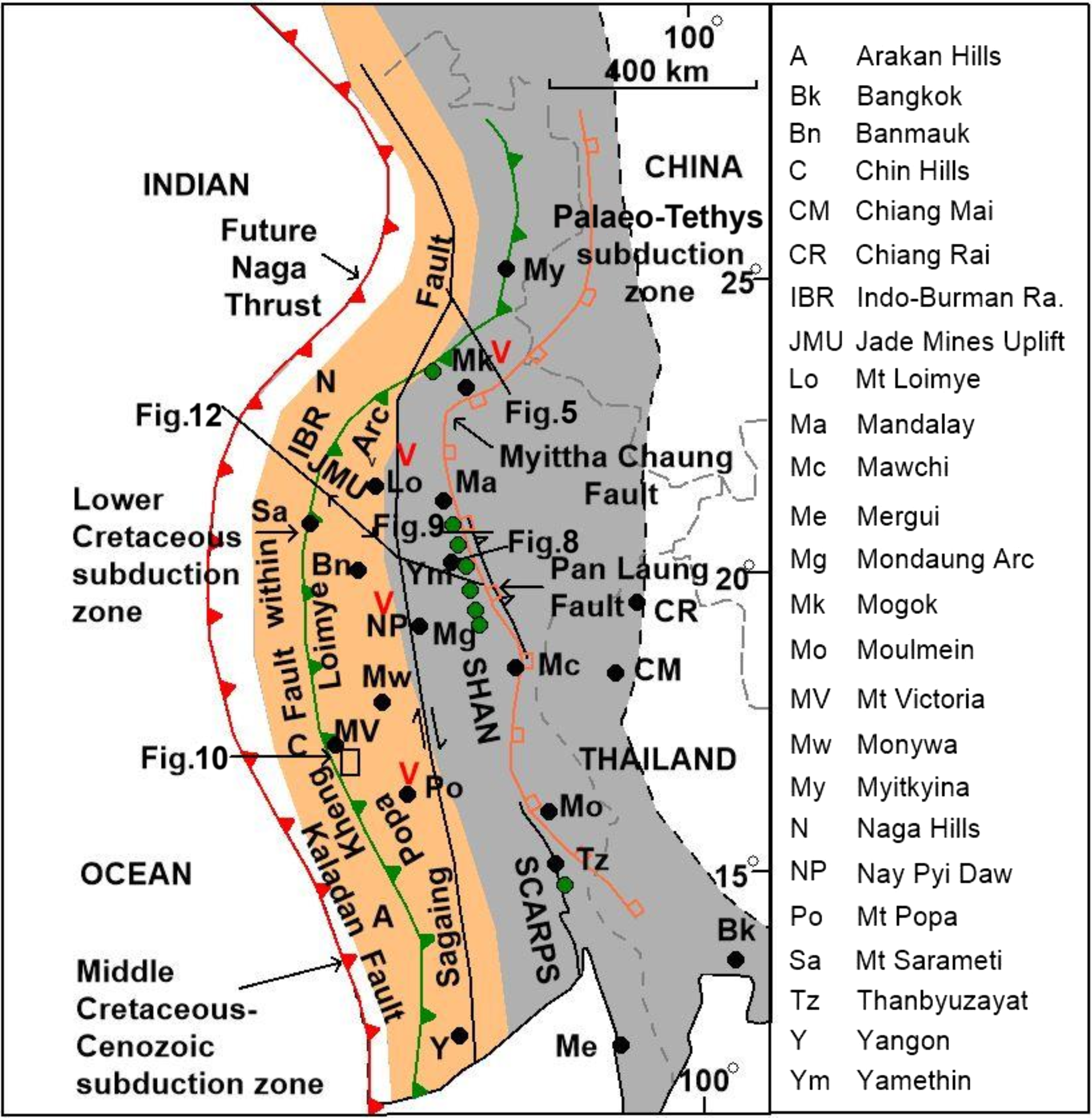
Fig. 2. Sketch map showing selected structural belts and location names with western Myanmar in restored pre-late Oligocene position prior to c. 450-km dextral strike-slip displacement on the Sagaing Fault. The width of Shan Scarps is exaggerated to allow for shortening on Pan Laung Fault. Red ‘V’s are Popa–Loimye Arc related to Kaladan Fault subduction zone. Green circles are Mondaung Arc related to subduction zone near Kheng Fault. Myittha Chaung Fault shown in orange. Offset on Sagaing Fault from Mitchell et al. (Reference Mitchell2015), with Naga Thrust from Evans (Reference Evans1964) and Kaladan Fault from Aitchison et al. (Reference Aitchison, Aliba, Bhowmik, Clarke, Ireland, Kachovich, Lokho, Stojanovic, Roeder, Truscott, Zhen and Zhou2019).
More recently many authors have supported the presence of two blocks – West Myanmar and Sibumasu – between Indo-China and India during Mesozoic time (e.g. Mitchell, Reference Mitchell1986; Gardiner et al. Reference Gardiner, Robb and Searle2014, Reference Gardiner, Searle, Robb and Morley2015, Reference Gardiner, Robb, Morley, Searle, Cawood, Whitehouse, Kirkland and Roberts2016). Others (Mitchell et al. Reference Mitchell, Chung, Lin and Hung2012; Deng et al. Reference Deng, Wang, Li, Li and Wang2014; Wang et al. Reference Wang, Deng, Carranza and Santosh2014) have projected within Sibumasu an additional suture zone SW-wards into Myanmar from the Santiashan (Luxi) zone (Fig. 1) of Mo et al. (Reference Mo, Lu and Shen1993) in Yunnan. This zone, part of the Medial Myanmar Suture Zone (Mitchell et al. Reference Mitchell2015) along the Shan Scarp (Fig. 1), lies between the reduced Sibumasu or Sibuma block (Ridd, Reference Ridd2016) to the SE and the Tengchong block of Deng et al. (Reference Deng, Wang, Li, Li and Wang2014), Wang et al. (Reference Wang, Deng, Carranza and Santosh2014) and Gardiner et al. (Reference Gardiner, Searle, Morley, Robb, Whitehouse, Roberts, Kirkland and Spencer2018) to the NW. Ridd et al. (Reference Ridd, Crow and Morley2019) invoked a larger Tengchong–Hukawng block that collided with Sibuma during early Tertiary time, after which the southern part of this block moved N-wards on the Sagaing Fault to become the Hukawng Basin (Fig. 1). Others (e.g. Searle et al. Reference Searle, Morley, Waters, Gardiner, Kyi, Than Than, Robb, Barber, Zaw and Crow2017) inferred a Mawgyi arc, additional to the West Myanmar block, between Sibumasu and India.
Models in which Sibumasu is the only block between Indo-China and India south of the latitude of Mogok (e.g. Gardiner et al. Reference Gardiner, Robb, Morley, Searle, Cawood, Whitehouse, Kirkland and Roberts2016, Reference Gardiner, Searle, Morley, Robb, Whitehouse, Roberts, Kirkland and Spencer2018; Zhang et al. Reference Zhang, Xiao, Windley, Wakabayashi, Cai and Wu2018) are not easily reconciled with the need for a root or suture zone for the ophiolites and their metamorphic soles in the Indo-Burman Ranges (Figs 1, 2) and in the Tagaung–Myitkyina Belt (Fig. 1). Other interpretations invoke dextral strike-slip for emplacement either of the Shan Scarps of Dutt (Reference Dutt1942) and western Myanmar along the Shan Scarp (Fig. 1) in the Cretaceous (Ridd & Watkinson, Reference Ridd and Watkinson2013), or of western Myanmar along a structure near the future Sagaing Fault in the Triassic (Barber & Crow, Reference Barber and Crow2009).
In this paper we put forward a new tectonic interpretation of Myanmar’s evolution west of the Salween based on two speculative former hypotheses. The first of these is the long-proposed post-Eocene dextral displacement on the Sagaing Fault of Win Swe (Reference Haile1972). Early estimates of this displacement ranged from 300 km (Mitchell, Reference Mitchell1977) to 460 km (Curray et al. Reference Curray, Moore, Lawver, Emmel, Raitt, Henry, Kieckhefer, Watkins, Montadert and Dickerson1979). Morley & Arboit (Reference Morley and Arboit2019) reviewed later proposals for c. 100 km to > 400 km of displacement on the Sagaing Fault and, from detrital zircon ages on sedimentary rocks in the North Minwun extensional basin 270 km north of Mandalay, together with extrapolation of the present-day movement rate back to 27 Ma, inferred a possible 486 km of displacement since middle Oligocene time. We here infer (Fig. 2) a provisional total dextral displacement of c. 450 km. The second hypothesis is for a major E–W (present orientation) crustal shortening (Fig. 3) of at least several tens of kilometres to explain the juxtaposition along the Shan Scarp (Fig. 1) of the Shan Plateau or Sibuma in the east with the Shan Scarps, part of Bender’s (Reference Bender1983) Karen–Tenasserim unit, and western Myanmar in the west. In our interpretation (Fig. 3) this shortening took place on a regional W-directed thrust which emplaced the Shan Plateau succession with migmatites of the Mogok Metamorphic Belt at the base, over the Slate Belt, partly Carboniferous in age, in the Scarps and southern Myanmar (Tanintharyi). We explain the otherwise problematic presence (Mitchell et al. Reference Mitchell, Ausa and Deiparine2004; Ridd, Reference Ridd, Barber, Zaw and Crow2017) of middle Permian – Triassic Plateau Limestone in the east and identical Moulmein Limestone overlying the Slate Belt in Tanintharyi in the west (Fig. 3b), by inferring that the shortening took place on a W-directed thrust during early Permian time, although a much younger age would otherwise be possible. Our proposal requires that the thrust surfaced to the west of the Shan Scarp and adjacent Myittha Chaung (River) Fault (Mitchell, Reference Mitchell2017), an inferred late Mesozoic extensional structure.

Fig. 3. Schematic generalized sequential E–W (present orientation) cross-sections through Myanmar between 16° and 22° N, from west of Shan Scarps to Shan Plateau, showing relationship of Mergui Group (part of Slate Belt) to Shan Plateau succession during (a) early Permian (after Mitchell, Reference Mitchell2017, fig. 29) and (b) Late Triassic time after crustal shortening on W-directed thrust, erosion and deposition of Plateau and Moulmein Limestones. The thrust is the Sakhanya Taung Fault or Thrust of subsequent figures.
Although published explanations relate many of the Cenozoic tectonic and mineralization events in Myanmar west of the Salween to collision with India (Searle et al. Reference Searle, Noble, Cottle, Waters, Mitchell and Horswood2007, Reference Searle, Morley, Waters, Gardiner, Kyi, Than Than, Robb, Barber, Zaw and Crow2017; Wang et al. Reference Wang, Deng, Carranza and Santosh2014; Gardiner et al. Reference Gardiner, Searle, Morley, Robb, Whitehouse, Roberts, Kirkland and Spencer2018), our interpretation implies that effects of this collision were largely confined to the Naga Hills in northwesternmost Myanmar.
2. Structural belts in Myanmar
In part following Mitchell (Reference Mitchell2017), we divide Myanmar into eastern and western geological provinces, each with their constituent structural belts, now offset on the Sagaing Fault (Fig. 1).
2.a. Belts east of the Sagaing Fault
In northeastern Myanmar the main or eastern strand of the Sagaing Fault forms the NW boundary of the Katha–Gangaw Range, a slightly sinuous ridge of meta-sedimentary clastic rocks mostly dipping SE beneath the Tagaung–Myitkyina Belt (Fig. 1) or Upper Irrawaddy Basin. The Tagaung–Myitkyina Belt is occupied by serpentinites, minor gabbros, diabase dykes and basalt lavas interbedded with volcanogenic sediments of the Ngapyawdaw Chaung Formation (United Nations, 1979 b), overlain in angular unconformity by middle Cretaceous Orbitolina limestone. The Belt is truncated in the SW by the Sagaing Fault. The Kumon Range, which includes high-grade metamorphic rocks, lies immediately west of the Katha–Gangaw Range and Sagaing Fault (Fig. 1); the Kumon Range has not been mapped geologically and is not considered further here.
Along its southern and eastern margins the Tagaung–Myitkyina Belt is juxtaposed on the high-angle Kyaukpyu Fault (Fig. 1) with metamorphic rocks that, together with granites, occupy the Mogok Metamorphic Belt and is up to 40 km wide. In the world-famous Mogok gem district, the belt consists of diopside phlogopite spinel-bearing marble in which ruby occurs in the absence of spinel, and sapphire is associated with syenite. Suggested stratigraphic ages of the belt, debated for over a century, range from Archaen to Cretaceous, and metamorphic ages from Archaen to Miocene. Searle et al. (Reference Searle, Garber, Hacker, Kyi, Gardiner, Waters and Robb2020) have shown that the syenites are accompanied by charnockite and that both occur as Jurassic sills. They identify a granulite facies event that occurred during 68–21 Ma (Fig. 4) in which the gemstones were generated from metamorphism of skarns and marbles. Sutherland et al. (Reference Sutherland, Meffre, Thompson, Goemann, Zin and Harris2019) obtained an age of 32.4 Ma for ruby, and Myint Myat Phyo et al. (Reference Wang, Guillong, Berger, Franz, Balmer and Krzemnicki2020) reported zircon U–Pb ages of Oligocene – early Miocene for a granulite facies event affecting spinel and ruby in the Mogok gemfields. Spinel and ruby-bearing marble and migmatites continue S-wards to Mandalay Hill (at Mandalay, Fig. 1) and migmatites occur intermittently through the Shan Scarps where, as the mixed gneisses of Dutt (Reference Dutt1942), they occupy a wide belt east of Naypyidaw (Bateson et al. Reference Bateson, Mitchell and Clark1972), and occur at Payangazu and at Kyaikkami south of Moulmein (Thet Paing Kyaw Win et al. 2020).
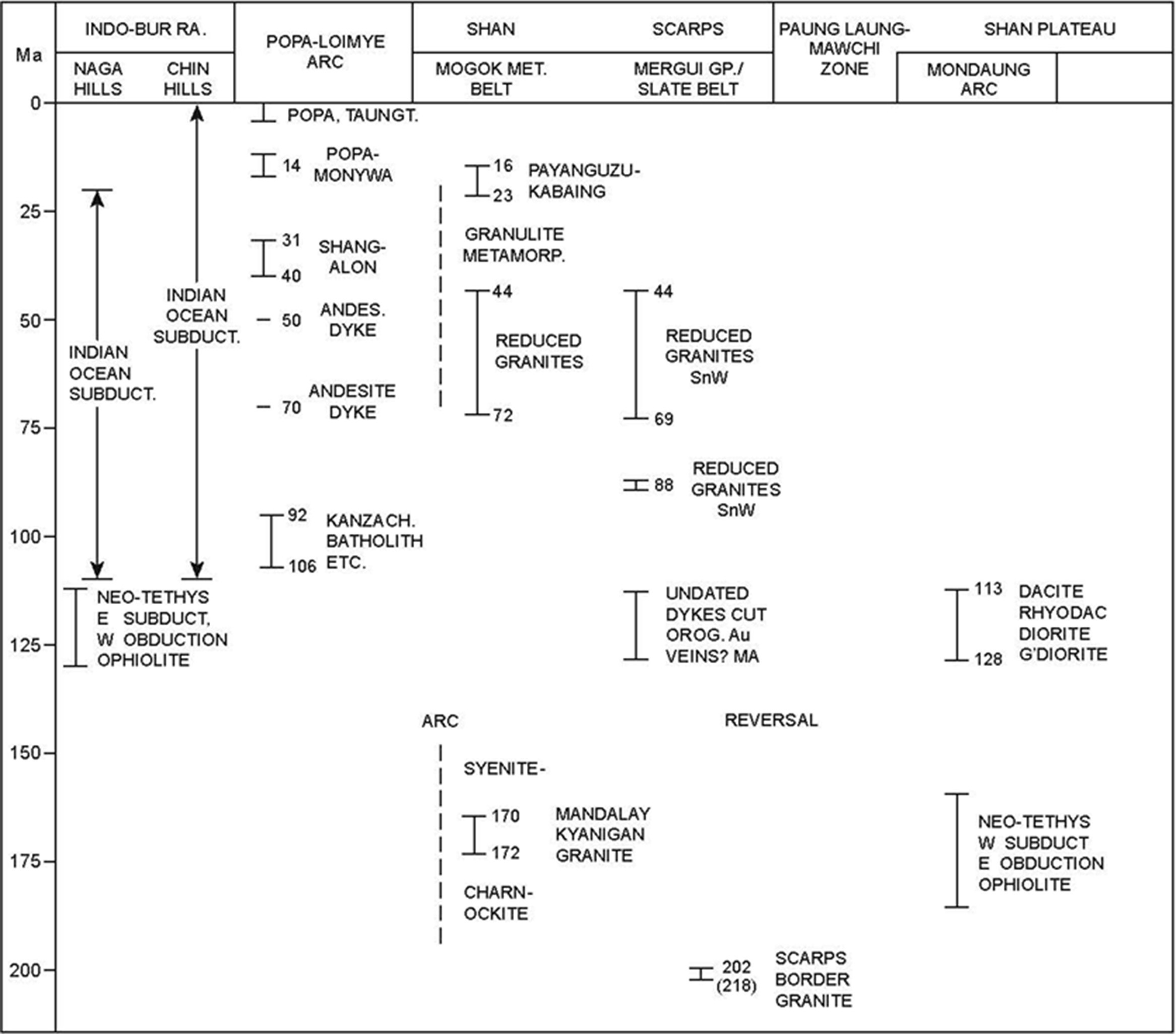
Fig. 4. Ages (Ma) of selected post-205-Ma rock units and geological events in Myanmar west of Salween. Details of isotopic age determinations in text.
South of Mogok (Fig. 1) the margin of the Metamorphic Belt is juxtaposed on an unnamed extensional fault (Mitchell, Reference Mitchell2017, fig. 2.7) with the overlying upper Proterozoic flyschoid Chaung Magyi Group, which underlies the Palaeozoic Shan Plateau succession as explained further in Section 3. The plateau succession (Fig. 3b) consists of the silicic Bawdwin Volcanics Formation and, as described in the recent review by Aye Ko Aung (2020), of overlying upper Cambrian clastic sediments, Ordovician–Devonian predominantly carbonate formations, local lower Carboniferous sandstones and shales, the lower Permian Yinyaw Formation of Hobson (Reference Hobson1941), and Permian – Upper Triassic Plateau Limestone (Thura Oo et al. 2002). An Upper Triassic – Lower Jurassic flysch locally overlies the Plateau Limestone and is succeeded by a Middle and Upper Jurassic shallow-marine formation and the overlying Kalaw (Hsipaw) Red Beds. We consider that the succession on the Shan Plateau, part of Sibuma (Ridd, Reference Ridd2016), continues through Baoshan (Fig. 1) in Yunnan into the Qiangtang Block in Tibet, and through northwestern Thailand and peninsular Malaysia. We see little evidence for the proposal of Gardiner et al. (Reference Gardiner, Searle, Morley, Robb, Whitehouse, Roberts, Kirkland and Spencer2018) that a Baoshan Block was separate during Palaeozoic time from Sibumasu.
The Shan Scarps lie east of the Sagaing Fault and west of the Paung Laung–Mawchi Zone (Fig. 1), a narrow belt bordering the Shan Plateau. The Scarps consist of the Slate Belt and Mogok Metamorphic Belt. The Slate Belt is composed of the Mergui Group, a thick succession of argillites, slates and quartzites with 516-Ma detrital zircons (Kyaw Linn Zaw et al. Reference Travnor and Win2020) overlain by Carboniferous diamictites, and the Taungnyo Group that is present near Moulmein (Fig. 1). In most places the Slate Belt occupies the eastern part of the Shan Scarps, and its boundary with the Mogok Metamorphic Belt to the west is the steep W-dipping Sakhanya Taung Fault, here interpreted as an early Permian thrust (Fig. 3). The Slate Belt is absent from the Mogok region, but reappears south of Tengchong and continues through the ‘Tengchong Block’ in Yunnan into NE Myanmar where it forms a 300-km long belt east of the Mogok Metamorphic Belt (Fig. 1). Mitchell (Reference Mitchell2017, fig. 7.12) and Mitchell et al. (Reference Mitchell and Lin2020 b) argued that in the Mogok region and the Shan Scarps the Slate Belt is overthrust by the Mogok Metamorphic Belt, but around Mogok the Slate Belt has yet to be exhumed. We therefore regard at least part of the Tengchong Block as the continuation of the Shan Scarps rather than as the discrete block of Gardiner et al. (Reference Gardiner, Searle, Morley, Robb, Whitehouse, Roberts, Kirkland and Spencer2018), bordered on the SE by the speculatively named Medial Myanmar Suture Zone. Lower Cretaceous intrusions in the Slate Belt form part of the recently identified Mondaung Arc (Fig. 2) of Lin et al. (Reference Lin, Mitchell and Chung2019 a), described further in Section 4.
Mitchell et al. (Reference Mitchell, Chung, Lin and Hung2012) and Mitchell (Reference Mitchell2017, p. 231) argued that within the Scarps zircon U–Pb ages on the Nattaung granite SE of Yamethin (Fig. 2) and on a diorite intruding migmatite near Payangazu (Fig. 1) constrain the age of the main metamorphic fabric in the Mogok Metamorphic Belt to > 72 Ma and probably to > 128 Ma, a conclusion dismissed by Searle et al. (Reference Searle, Garber, Hacker, Kyi, Gardiner, Waters and Robb2020, p. 2) who claimed that the authors thought they were dating the regional metamorphism.
2.b. Belts west of the Sagaing Fault
Myanmar west of the Sagaing Fault can be divided into the Central Myanmar Basin with crust of normal continental thickness (Sloan et al. Reference Sloan, Elliott, Searle, Morley, Barber, Zaw and Crow2017), and the Indo-Burman Ranges (Fig. 1). The basin is bisected by the Popa–Loimye magmatic arc, a discontinuous chain of magmatic rocks of middle Cretaceous – Quaternary age, separated from the Sagaing Fault by the Shwebo Basin and from the Indo-Burman Ranges by a fore-arc basin (Win Swe 1981) with up to 17 km (Pivnic et al. Reference Pivnic, Nahm, Tucker, Smith, Nyein, Nyunt and Maung1998) of Albian–Quaternary sedimentary rocks. The fore-arc basin is divided into sub-basins, of which the Chindwin and Hukawng are separated by the metamorphic rocks (Chhibber Reference Chhibber1934 a, p. 25) of the Jade Mines Uplift (Fig. 1).
In the southern part of the Indo-Burman Ranges (Fig. 1), United Nations (1979 a) recognized an Eastern Belt of meta-sedimentary rocks, Triassic flysch, ophiolites and pillow basalts, and a Western Belt of Campanian and Maastrichtian mudstones and Globotruncana-bearing pelagic limestones of the Falam Formation, exposed in eroded anticlines between lower Palaeogene turbidite sandstones and mudstones preserved in high-elevation synclines (Mitchell Reference Mitchell2017, figs 11.5, 11.6). The flysch, ophiolites and basalts of the Eastern Belt are overlain in the east by the middle Cretaceous Orbitolina Limestone, locally succeeded by the Campanian–Maastrichtian Kabaw Formation of Aung Khin & Kyaw Win (1968) and Win Swe (Reference Haile1972), equivalent to the Falam Formation of the Western Belt. The Orbitolina Limestone and Kabaw Formation are the basal formations of the fore-arc basin.


Fig. 6. Geological map of part of Shan Scarps and Shan Plateau margin after Garson et al. (Reference Garson, Amos and Mitchell1976), United Nations (1979 c) and Mitchell et al. (Reference Mitchell, Ausa and Deiparine2004). a – augen gneiss and gneissic granite; B – Bon Schist; D – diorite; G – two-mica granite; Gd – granodiorite; Gs – Sedo Granite and equivalents; Jl – Loi-an Formation; JKp – Pettalet Formation; Kk – Kalaw Red Beds; Kp – Pyinyaung Formation; m – marble; Pt – Thitsipin Limestone, locally including Yin Yaw Formation; PTn – Nwabangyi Dolomite; Q – alluvium; SBG – Scarps Border granite; Te – Neogene sediments; TJp – Pinmon East Limestone; TJs – Shweminbon Formation; YWD – Yinmabin West Diorite. Mogok Metamorphics: y – Yinmabin Schist; ms – migmatites and schist. Slate Belt: Cp – Kogwe Mudstone; Pzw – Poklokkale Wacke; PMZ – Paung Laung-Mawchi Zone; Sk – Shweminbon Au–Cu skarns; Ym – Yamethin. Location on Figure 1. Partly from Myanmar Geosciences Society (2014).
In the Naga Hills, Bannert et al. (Reference Bannert and Lyen2011) and Aitchison et al. (Reference Aitchison, Aliba, Bhowmik, Clarke, Ireland, Kachovich, Lokho, Stojanovic, Roeder, Truscott, Zhen and Zhou2019) describe their Naga Metamorphics that underlie the 3826-m elevation Mount Sarameti (Fig. 2) in the east, and are translated NW-wards on the Sarameti Thrust over ophiolitic rocks within a mud-matrix melange. The Waziho Thrust, equivalent to the Kheng Fault in the Chin and Rakhine Hills (Fig. 2), carries the ophiolites and melange over the Tertiary Indo-Burman flysch of Bannert et al. (Reference Bannert and Lyen2011). The flysch is correlated with the Disang Group of Evans (Reference Evans1964) by Aitchison et al. (Reference Aitchison, Aliba, Bhowmik, Clarke, Ireland, Kachovich, Lokho, Stojanovic, Roeder, Truscott, Zhen and Zhou2019), who consider it to be derived from and deposited on the Indian Plate. For Aitchison et al. (Reference Aitchison, Aliba, Bhowmik, Clarke, Ireland, Kachovich, Lokho, Stojanovic, Roeder, Truscott, Zhen and Zhou2019) the India–Myanmar suture zone is the Waziho Thrust, while for Yang et al. (Reference Yang, Xiao, Rahman, Windley, Schulman, Ao, Zhang, Chen, Hissain and Dong2020) in the Chin Hills the suture is the Kaladan Fault (Fig. 2), which they project NE-wards into the Naga Thrust of Evans (Reference Evans1964) in Assam.
3. The Katha–Gangaw–Mogok cross-section: E-vergent orogeny and reversal in tectonic polarity
East of the Sagaing Fault near Mogok the SE-dipping succession (Fig. 5) of the Mogok Metamorphic Belt is overlain by the Chaung Magyi Group on an unnamed structure. This has been interpreted as an extensional fault (Mitchell, Reference Mitchell2017), possibly the continuation of the Myittha Chaung Fault (Fig. 2), because at the lithological boundary sericite semi-schists (Chaung Magyi) overlie high-grade schists and gneisses (Mogok Belt) to the NW, and because a SE-dipping fault could explain evidence for late Cenozoic uplift of the Metamorphic Belt. The Chaung Magyi Group is overlain unconformably by the Cambrian–Tertiary succession that includes the Upper Triassic – Lower Jurassic Napeng flysch. In the Tagaung–Myitkyina Belt NW of the Mogok Metamorphic Belt and Kyaukhpyu Fault (Fig. 1), pillowed and massive basalts, diabase dykes, andesites and volcanogenic sediments of the Ngapyawdaw Chaung Formation, and serpentinites and chlorite schists (Than Tun & Khin Myint, personal communication, 2002), are intruded by hornblende biotite granites and dacitic dykes. Near Myitkyina, Yang et al. (Reference Yang, Xu, Duan, Li, Xiong, Liu, Cai and Li2012) reported Middle Jurassic (c. 173 Ma) zircon U–Pb ages of basalt, leucogabbro, plagiogranite and pyroxenite, and Liu et al. (Reference Liu, Chung, Wu, Zhang, Xu, Wang, Chen and Guo2016) obtained Upper Jurassic ages of c. 162 Ma on diorites and gabbro. The isolated Tagaung Taung (hill), shown on Figure 1, consists of chromitite-bearing dunites and harzburgites overlying a metamorphic sole thrust over cherts (United Nations, 1979 b) containing uppermost Jurassic – Aptian (Teza Kyaw et al. Reference Suzuki2020) radiolaria, and locally over Upper Triassic turbidites. South of Tagaung, Maung Maung et al. (Reference Suzuki, Swe, Tun, Thant and Zaw2014) described uppermost Jurassic cherts overlying red mudstones. The middle Cretaceous Orbitolina Limestone of Sahni (Reference Sahni1937), preserved in synclines, lies unconformably on the Ngapyawdaw Chaung Formation.
We interpret the Napeng turbidites on the Plateau (Fig. 5a) as an orogenic flysch deposited on and west of the Sibumasu passive continental margin, and ophiolitic rocks in the Tagaung–Myitkyina Belt and at Santiashan (Chu et al. Reference Chu, Wang, Chen, Wang, Li and Ji2009) in southwestern Yunnan as part of an oceanic arc obducted E-wards over the flysch and accreted to the western margin of Sibumasu during Early Jurassic time; in the terminology of Draut & Clift (Reference Draut and Clift2013), this was a forward-facing collision. We infer that ophiolite obduction and flysch deformation preceded deposition of the upper Bathonian – Callovian Tati Limestone unconformable on Napeng flysch (Brunnschweiler, Reference Brunnschweiler1970), and that limestone deposition accompanied a reversal in orogenic polarity. The reversal led to E-wards subduction of the remaining Neo-Tethys beneath Sibumasu, generating the Mondaung arc of Lin et al. (Reference Lin, Mitchell and Chung2019 a).
On its western side the Tagaung–Myitkyina Belt is underlain structurally by the Katha Schist which includes quartzites and mica-schists with local kyanite, and contains detrital zircons with ages of 418 Ma and older and a peak in zircon age frequency at 500 Ma (Zhang et al. Reference Zhang, Xiao, Windley, Wakabayashi, Cai and Wu2018). The schist, which forms the Katha–Gangaw Range, has been interpreted as part of an island-arc or small continental block, the Victoria–Katha Block (Fig. 1), with Upper Triassic turbidites (Fig. 5a) on its passive eastern margin (Mitchell et al. Reference Mitchell and Lin2020 b). In our interpretation, before E-wards subduction of Neo-Tethys ceased, the Victoria–Katha Block and its turbidite cover were over-ridden by an ophiolite nappe and overlying Upper Jurassic – Lower Cretaceous oceanic island-arc rocks (Ngapyawdaw Chaung Formation) and cherts expelled from the Neo-Tethys (Fig. 5b). As the ocean closed, this nappe stack was overridden by the Sibumasu plate margin with its E-vergent nappes of flysch and Lower Jurassic ophiolite (Fig. 5b, c). The Tagaung–Myitkyina Belt was then overlain unconformably by the middle Cretaceous Orbitolina Limestone. The Victoria–Katha Block is distinct from the numerous West Burma (Myanmar) Blocks postulated since the late 1970s, in that it includes the Katha–Gangaw Range that lies east of the Sagaing Fault. The Indo-Burma-Andaman microcontinent of Bandyopadhyay et al. (Reference Bandyopadhyay, van Hinsbergen, Plunder, Bandyopadhyay, Advokaat, Chattopadhaya, Morishita, Ghosh, Ray and Radhakrishna2020) occupies a structural position similar to that of the Victoria–Katha Block, but lacks Triassic flysch and collided with Asia only after middle Cretaceous time. The high-angle Kyaukpyu Fault (Figs 1, 5c) may be a NW-dipping extensional fault, now rotated to near-vertical, on which Late Cretaceous uplift in the footwall formed the broad regional syncline in the Shan Plateau succession to the SE.
4. The Sedo Granite and Payangazu cross-sections, and the Mondaung Arc in the Shan Scarps
We argued in Sections 1 and 2.a above that in the Shan Scarps (Figs 6, 8) the main body of the Mogok Metamorphic Belt is part of a thrust sheet overlying the Mergui Group or Slate Belt on the W-dipping Sakhanya Taung Fault. A cross-section from the Sedo and Nattaung Granites south of Kalaw (Fig. 8) includes the Bon Schist (Mitchell et al. Reference Mitchell, Ausa and Deiparine2004). This narrow discontinuous strip of diopside-phlogopite marble, schist and granite at the eastern margin of the Slate Belt resembles part of the Mogok Metamorphic Belt, and is juxtaposed with folded upper Mesozoic sedimentary rocks of the 1–2-km wide Paunglaung–Mawchi zone (Figs 6, 7, 8) on the regional Myittha Chaung Fault, an E-dipping extensional structure (Mitchell, Reference Mitchell2017, p. 344). The boundary between the Paung Laung–Mawchi zone and the Shan Plateau succession to the east (Figs 8, 9) is the projected Pan Laung Fault of Garson et al. (Reference Garson, Amos and Mitchell1976), the Shan Scarp Fault of Chit Thet Mon et al. (Reference Gong, Wen, Jiang, Chen, Zhang, Hou and He2020). The fault is here interpreted as a folded thrust on which the lower Permian Yin Yaw Formation and middle Permian – Upper Triassic Plateau Limestone are emplaced over the undated Ngayan Chaung Turbidites.

Fig. 7. Map of principal (Myanmar) segment of Western Tin Belt of Myanmar and Thailand showing location of larger of 400 lode tin and tungsten mines described by Clegg (Reference Clegg1944). B – Bwabin (W,Sn); Bo – Bokpyin (Sn,W); H – Hermyingyi (W,Sn); K – Kalonta (Sn,W); Ka – Kanbauk (Sn,W); M – Mawchi (Sn,W); P – Palauk (W,Sn); Pa – Padatgyaung (W); Pe – Pedwe Taung (W); Pg – Pagaye (W,Sn); T – Tagu (W,Sn); Th – Than Island (W); W – Wagon (W,Sn); Y – Yadanabon (W,Sn). From Clegg (Reference Clegg1944), Geological Map of Myanmar (2014) and Gardiner et al. (Reference Gardiner, Robb, Morley, Searle, Cawood, Whitehouse, Kirkland and Roberts2016).

Fig. 8. Cross-section through Shan Scarps and Shan Plateau margin near Kalaw (NCT – Ngayan Chaung Turbidites; PMZ – Paung Laung-Mawchi Zone); Sakhanya Taung Fault is early Permian thrust on Figure 3. Kalaw Red Beds are in Kalaw Syncline. The cross-section is interrupted on Figure 6 but indicated approximately by single line on Figure 2.

Fig. 9. Cross-sections in early Cretaceous (a) and present-day (b) through Payangazu and Pyinyaung in Shan Scarps onto Shan Plateau showing geological evolution. The Victoria-Katha plate consists of part of Neo-Tethys plus the Victoria-Katha Block. PMZ Paung Laung-Mawchi Zone. Yebokson Granodiorite, dacite sills and Patchaung Volcanics are part of Mondaung Arc. Mergui Gp is part of Slate Belt. Location on Figures 2, 6.
The Plateau Limestone is overlain in the Kalaw Syncline shown in the east of Figure 8 by the Upper Triassic – Lower Jurassic Shweminbon Formation (Figs 8, 9), interpreted as an orogenic flysch equivalent of the Napeng Formation (Fig. 5), deposited on and oceanwards of the Sibumasu passive margin and thrust E-wards during obduction of the Neo-Tethys Santiashan ophiolite (Fig. 1) since removed in this area by erosion. The Shweminbon flysch includes the Jurassic Pinmon East Limestone (Figs 6, 8). We suggest that Upper Triassic zircons in the flysch and associated Middle–Upper Jurassic Loi-an Formation to the east were derived from granites similar to the 202-Ma Scarps Border granite of Lin et al. (Reference Lin, Mitchell and Chung2019 a) east of Payangazu (Figs 4, 6), rather than from the Upper Triassic granites in eastern Myanmar as argued by Cai et al. (Reference Cai, Ding, Yao, Laskowski, Xu and Zhang2017). Abundant detrital feldspar (authors’ unpublished observations) in the Loi-an Formation SE of Kalaw may have been derived from the Scarps Border granites.
In the highly accessible Payangazu area (Figs 1, 6, 9a), biotite schists of the Mogok Metamorphic Belt overlie sericite schist assigned to the Mergui Group on the W-dipping Sakhanya Taung Fault, but display an apparent inverted metamorphic gradient in which biotite schist and marble pass up-section and W-wards into garnet and sillimanite schist. The Mergui Group is here intruded by the 121-Ma Yebokson Granodiorite (Barley et al. Reference Barley, Pickard, Rak and Doyle2003). As in the Sedo–Kalaw section to the south (Figs 6, 8), the Mergui Group is juxtaposed with the Loi-an Formation, here known as the Kyaukhsu Taung Formation, and with the overlying Cretaeous Pyinyaung Formation, on the N-wards continuation of the Myittha Chaung extensional fault (Figs 2, 9b). Along the Shan Scarp the Pyinyaung Formation is overthrust on the projected Pan Laung Fault of Garson et al. (Reference Garson, Amos and Mitchell1976) by the Plateau Limestone.
In our interpretation the Early Jurassic E-vergent orogeny in the Shan Scarps and Plateau, in the same way as that SE of Mogok described in Section 3 and shown to the east in Figure 5, was followed by end-Jurassic reversal in tectonic polarity, and E-wards subduction of the Neo-Tethys (Fig. 9a). This subduction can explain generation of the Tengchong to Kalaw continental margin arc of Zhang et al. (Reference Zhang, Xiao, Windley, Wakabayashi, Cai and Wu2018) or Mondaung (formerly Mondaung–Lawa) arc (Lin et al. Reference Lin, Mitchell and Chung2019 a; Mitchell et al. Reference Mitchell and Lin2020 b), with a zircon U–Pb age range of 113–128 Ma (Fig. 4) in and east of the Shan Scarps. The arc has subduction-related characeristics and isotopic evidence of a component of old crustal melt. It includes the 119-Ma Lawa Diorite (Khin Zaw Reference Khin Zaw, Barber, Zaw and Crow2017; Lin et al. Reference Lin, Mitchell, Chung, Tan, Tang and Wu2019 a) intrusive into the Shweminbon turbidites east of Lebyin (Fig. 6), the 121-Ma Yebokson Granodiorite (Barley et al. Reference Barley, Pickard, Rak and Doyle2003) within the Mergui Group and the nearby 128-Ma Yinmabin West Diorite (Mitchell et al. Reference Mitchell, Chung, Lin and Hung2012) in the Mogok Metamorphic Belt (Figs 6, 9); several c. 121-Ma rhyodacitic intrusions at and south of Mondaung, including that at Lebyin (Lin et al. 2019a) and those described by Garson et al. (Reference Garson, Amos and Mitchell1976) from the footwall of the Pan Laung Fault; the Kyaukse (Fig. 1) augen gneiss with a magmatic age of 114 Ma (Mitchell et al. Reference Mitchell, Chung, Lin and Hung2012); and a 113-Ma dacitic clast in the Pyinyaung Conglomerate. The arc may also include the Patchaung Volcanics (Fig. 6) of United Nations (1979 c), the 121-Ma granodiorite of Mi Paik & Khin Zaw (Reference Swe, Tun, Thant and Zaw2014) near Thanbyuzayat (Fig. 2), the 121-Ma granite of Thet Paing Kyaw Win et al. (2020) at Kyaikkami (Fig. 1), and perhaps the undated I-type granites of Cobbing et al. (Reference Cobbing, Pitfield, Derbyshire and Mallick1992) in the Coastal Ranges of Tanintharyi south of Moulmein (Figs 1, 7). The arc is lost beneath alluvium north of Mondaung (Fig. 1) but probably re-appears in the Tagaung–Myitkyina Belt as the 117-Ma dacite porphyry dyke (Mitchell et al. Reference Mitchell and Lin2020 b) NW of Mogok (Fig. 2). The youngest age determined in the arc implies that subduction of Neo-Tethys and the Victoria–Katha Block beneath Sibumasu ended at c. 112 Ma.
On Figures 6 and 8 we interpret the Pan Laung Fault of Garson et al. (Reference Garson, Amos and Mitchell1976) as a folded E-directed thrust on which the western edge of the upper plate lies east of the Shan Scarps. On the Shan Plateau the equivalents of the Patchaung Volcanics (Fig. 6) appear to lie within an erosional window in the overthrust Plateau Limestone (Mitchell, Reference Mitchell2017, p. 131). In the footwall of the Myittha Chaung Fault (Figs 8, 9), uplift and consequent erosion can explain the absence of the plateau succession above the Mogok Metamorphic Belt and Mergui Group.
The Lawa Diorite (Fig. 6) hosts gold-copper skarn deposits (Khin Zaw Reference Khin Zaw, Barber, Zaw and Crow2017; Mitchell, Reference Mitchell2017) and an iron skarn with an associated major magnetic anomaly; copper-gold skarns occur elsewhere in the arc. Undated dacitic and andesitic dykes intruding auriferous veins of the Modi Taung orogenic gold district (Mitchell et al. Reference Mitchell, Ausa and Deiparine2004) shown on Figure 6 may be part of the Mondaung arc, suggesting that the veins formed before 128 Ma.
5. Chin Hills and Sin Chaung extensional fault, Indo-Burman Ranges
The southern Chin Hills (Fig. 10a), the best-known segment of the Indo-Burman Ranges, are described here because the Chin Hills structure is comparable to that of the Naga Hills – Jade Mines area, discussed in Section 6.

Fig. 10. Southern Chin Hills, Indo-Burman Ranges. (a) Geological sketch map of Sin Chaung–Mahin Chaung valley, eastern limb of Mindat Anticline. Narrow pink areas along Sin Chaung Fault are pillowed basalt, Orbitolina Limestone and Kabaw Formation. A – Apaw; K – Kanpetlet; L – Laungshe; S – Saw; SG – Swe Le Gyin; SK – Su boke kyin; T – Thigon. Location shown on Figure 1. (b) Schematic composite cross-section through Sin Chaung valley and Fault near 21° N, not to scale, thickness of Orbitolina Limestone exaggerated to show limestone lithologies and serpentinite sheets.
The Upper Triassic Pane Chaung Group of United Nations (1979 a) is equivalent to the Thanbaya Formation described in 1970s unpublished reports by the then Burma Oil Corporation and, although not reported by Brunnschweiler (Reference Brunnschweiler1966), is widespread in the Eastern Belt of the Chin Hills (Fig. 10a) and Arakan (Rakhine) Yoma. The Pane Chaung Group is a thick deformed sandstone turbidite formation or flysch with widespread broken beds, overturned locally horizontal bedding, and Upper Triassic Daonella reported by Theobald (Reference Theobald1871) and Gramman (Reference Gramman1974). United Nations (1979 a) showed that the group is underlain by Brunnschweiler’s (Reference Brunnschweiler1966) Kanpetlet Schist, which includes deformed pillowed basalts metamorphosed to quartz-epidote-albite schist. Within the flysch in the northern Chin Hills, United Nations (1979 a) mapped ultramafic bodies including Webula Taung with its metamorphic sole, from which they inferred that the ophiolite was obducted W-wards onto the flysch. The flysch is overlain by pillowed basalts (Fig. 10b) previously regarded as part of the ophiolite, but here they are interpreted as equivalent to the Mawgyi Volcanic Group in the Popa–Loimye arc. Rare mafic dykes intrude the flysch. Recent work has established zircon U–Pb ages of 127 Ma for plagiogranite in the Webula ultramafic body and 116 Ma for its amphibolitic sole (Liu et al. Reference Liu, Chung, Wu, Zhang, Xu, Wang, Chen and Guo2016), the latter indicating the approximate age of the obduction which accompanied closure of the Neo-Tethys. The presence of radiolarian cherts with Middle and latest Jurassic and middle Early Cretaceous ages in the Naga Hills (Aitchison et al. Reference Aitchison, Aliba, Bhowmik, Clarke, Ireland, Kachovich, Lokho, Stojanovic, Roeder, Truscott, Zhen and Zhou2019) and Middle Jurassic ages in the Chin Hills (Zhang et al. 1918) indicates that oceanic rocks in the Tagaung–Myitkyina Belt and Indo-Burman Ranges have a similar maximum age.
Mitchell (Reference Mitchell1986) interpreted the Pane Chaung Group as an orogenic flysch deposited on the passive eastern margin of his Mount Victoria Land, a continental fragment that we include here in the Victoria–Katha Block; deformation of the flysch was explained by obduction of ophiolite onto the block during the Late Jurassic Epoch. More recently, Sevastjanova et al. (Reference Sevastjanova, Hall, Rittner, Alderton and Comfort2015) inferred from detrital zircons that the flysch was derived from the area east of the Palaeo-Tethys suture zone in easternmost Myanmar (Fig. 2). The cross-sections of Zhang et al. (Reference Zhang, Xiao, Windley, Wakabayashi, Cai and Wu2018) similarly indicate that the Pane Chaung flysch was derived from Myanmar and accreted to its western margin. Cai et al. (Reference Cai, Ding and Yao2020) have since reported 200–290-Ma-aged detrital zircons in the Pane Chaung flysch, correlated it with the Triassic flysch of the Tethyan Himalaya, and concluded that the Pane Chaung flysch was deposited in an Upper Triassic submarine fan along the northern margin of Australia, and derived from West Papua.
Limestone containing the Albian–Cenomanian foraminifera Orbitolina was described by Gramman (Reference Gramman1974) from stream sections east of Mount Victoria in the southern Chin Hills, and to the south (Fig. 10a) by United Nations (1979 a) who reported an upper Albian ammonite, and a basal conglomerate with clasts of basalt and ?Triassic sandstone lying depositionally on Triassic flysch. The limestone provided a minimum age for flysch deformation beneath the advancing ophiolite and for eruption of the pillowed basalt. The limestone was penetrated in an oil borehole in the east of the fore-arc basin and overlies the Mawgyi Volcanic Group on the western flank of the Popa–Loimye arc (United Nations, 1978; Mitchell, Reference Mitchell2017, p. 289).
United Nations (1979 a) interpreted the Kanpetlet Schist in the southern Chin Hills as the core of the Mindat anticline with Triassic flysch in the eastern (Fig. 10a) and western limbs. The schist has been re-interpreted as either an upthrust wedge (Rangin et al. Reference Rangin, Maurin and Masson2013; Yang et al. Reference Yang, Xiao, Rahman, Windley, Schulman, Ao, Zhang, Chen, Hissain and Dong2020) as shown in Figure 10, or a W-overturned fault-bounded anticline (Zhang et al. Reference Zhang, Xiao, Windley, Cai and Naing2017, Reference Zhang, Xiao, Windley, Wakabayashi, Cai and Wu2018, Reference Zhang, Xjao and Cai2020). The eastern boundary of the Kanpetlet Schist was described as a W-dipping reverse fault by Rangin et al. (Reference Rangin, Maurin and Masson2013) and Yang et al. (Reference Yang, Xiao, Rahman, Windley, Schulman, Ao, Zhang, Chen, Hissain and Dong2020), and as an E-dipping normal fault by Zhang et al. (Reference Zhang, Xiao, Windley, Wakabayashi, Cai and Wu2018, Reference Zhang, Xjao and Cai2020). The boundary between the Triassic flysch and the fore-arc basin succession was regarded by Chhibber (Reference Chhibber1934 b, p. 220) as a normal fault, later called the Kabaw Fault and interpreted by Yang et al. (Reference Yang, Xiao, Rahman, Windley, Schulman, Ao, Zhang, Chen, Hissain and Dong2020) as a strike-slip structure, but the fault is not shown on the cross-sections of Pivnic et al. (Reference Pivnic, Nahm, Tucker, Smith, Nyein, Nyunt and Maung1998) and has not been identified on satellite images.
In our interpretation the Pane Chaung flysch was deposited on and oceanwards of the Victoria–Katha Block (Fig. 11), then a part of Australia in Gondwana (Cai et al. Reference Cai, Ding and Yao2020). During the Early Cretaceous Epoch the flysch was overthrust by an obducted Neo-Tethys ophiolite during the rifting of the block and its drift from Australia in front of the expanding Indian Ocean. We correlate the obducted ultramafic rocks in the Chin Hills with the Nat Hmaw and Tawmaw serpentinites (Figs 11, 12) flanking the Jade Mines Uplift, and infer that, during ophiolite obduction, the Victoria–Katha Block and its flysch cover subducted beneath Sibumasu and were since exhumed as the Kanpetlet Schist, as schists in the Jade Mines Uplift and the Katha–Gangaw Range, and as the meta-sedimentary rocks of probable Ordovican and younger age reported by Aitchison et al. (Reference Aitchison, Aliba, Bhowmik, Clarke, Ireland, Kachovich, Lokho, Stojanovic, Roeder, Truscott, Zhen and Zhou2019) in the Naga Metamorphic Complex (Fig. 1) around Mount Sarameti (Fig. 12). Exhumation may have preceded deposition in the fore-arc basin of the middle Palaeocene – lower Eocene Paunggyi Formation (Fig. 10) that lies with a regional unconformity on the Kabaw Formation and the Paung Chaung (Orbitolina) Limestone.
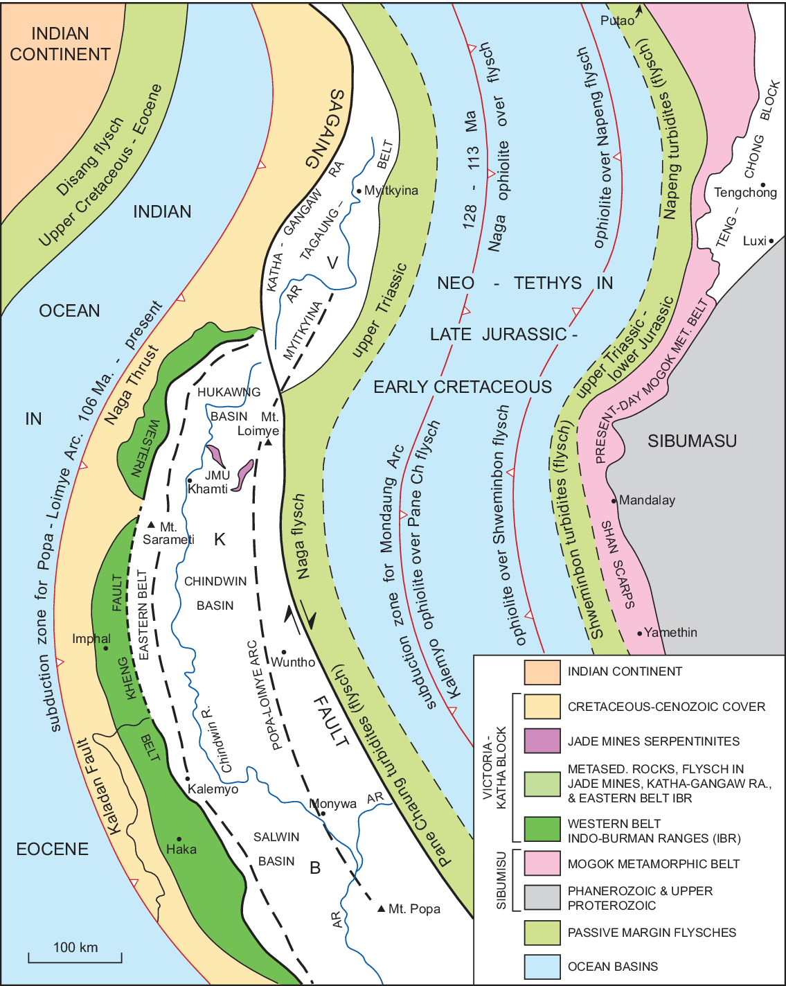
Fig. 11. Sketch map reconstruction showing Sibumasu and Victoria–Katha Block separated by the Neo-Tethys during Late Jurassic – Early Cretaceous time, and the Victoria–Katha Block and India separated by the Indian Ocean during Eocene time, with flysch deposits on passive margins of continental blocks, and detached ophiolite slabs prior to their obduction over the flysch. Jade Mines Uplift (JMU) flanked by Nat Hmaw (west) and Tawmaw (east) jadeite-bearing serpentinites shown in present positions. AR – Ayeyawady River.

Fig. 12. Schematic cross-section from Naga Hills through Jade Mines Uplift to Shan Scarps showing jadeite dykes in Early Cretaceous subduction zone associated with Mondaung Arc. Naga Hills thrust geometry modified from Aitchison et al. (Reference Aitchison, Aliba, Bhowmik, Clarke, Ireland, Kachovich, Lokho, Stojanovic, Roeder, Truscott, Zhen and Zhou2019) and Bannert et al. (Reference Bannert and Lyen2011) to reconcile with southern Chin Hills, where flysch and ophiolite are thrust over meta-sedimentary rocks. Suspected Triassic flysch in Naga Hills omitted in accordance with Bannert et al. (Reference Bannert and Lyen2011) and Aitchison et al. (Reference Aitchison, Aliba, Bhowmik, Clarke, Ireland, Kachovich, Lokho, Stojanovic, Roeder, Truscott, Zhen and Zhou2019). Simplified elements of Shan Scarps geology east of Sagaing Fault in restored pre-late Cenozoic position. LC – Lower Cenozoic sediments; PLA – Popa–Loimye Arc. Location on Figures 1, 2.
The Orbitolina Limestone is intruded by serpentinite sills or sheets up to 10 m thick (Chhibber, Reference Chhibber1934 b; United Nations, 1979 a; Mitchell et al. Reference Mitchell and Ibotomboi2010), abundant along the Sin Chaung in the southern Chin Hills (Fig. 10a, b), where a conglomerate at the limestone base contains pebbles of Triassic sandstone and basalt. The sills may be similar to those reported by Brunnschweiler (Reference Brunnschweiler1966) in his Senonian limestone. We explain the relationship between the flysch and overlying rocks by invoking a regional extensional structure, the Sin Chaung Fault, displacement on which has downthrown the overlying fore-arc basin succession relative to the ultramafic rocks and underlying flysch in the footwall to the west (Fig. 10b). We attribute the dismembered nature and scattered distribution of the larger ultramafic bodies to shearing of a formerly continuous obducted slab as the footwall was exhumed, and interpret the serpentinite sheets as sills mobilized from underlying ophiolite during faulting. We think this zone is unlikely to be a subduction channel analogous to that of Draut & Clift (Reference Draut and Clift2013) because displacement post-dates deposition of the Albian–Cenomanian Orbitolina Limestone and is therefore co-eval with Popa–Loimye arc magmatism, believed by most authors to be related to subduction near or west of the Kaladan Fault (Figs 2, 12). Ophicalcite or listwaenite at the serpentinite–limestone contact (United Nations, 1979 a; Mitchell, Reference Mitchell1985, Reference Mitchell1993), the silicic rocks of Chhibber (Reference Chhibber1934 b), imply up-dip ascent of hydrothermal water beneath the inclined impermeable serpentinite sheets, and replacement of overlying limestone. The Sin Chaung Fault at its present erosion level forms the eastern boundary of Triassic flysch, suggesting that this fault rather than the inferred Kabaw Fault to the east separates the Indo-Burman Ranges from the fore-arc basin. Obduction of the ophiolite before deposition of the limestone cover establishes that the ophiolite originated in the Neo-Tethys, not in the Indian Ocean to the west where subduction began in the Albian (Fig. 11).
6. Jade Mines Uplift and the Mondaung Arc subduction zone
With the proposed c. 450-km dextral displacement on the Sagaing Fault restored (Figs 2, 11), the Jade Mines Uplift and adjacent southern Naga Hills lie to the west of the Shan Scarps at latitude 20° 30ʼ N, while the northeastern end of the fore-arc basin and Naga Hills become continuous with the southwestern end of the Tagaung–Myitkyina Belt and Katha–Gangaw Range.
The Jade Mines Uplift (Fig. 11) is separated from the main or easternmost strand of the Sagaing Fault by a narrow segment of ruby-bearing diopside-phlogopite marble and biotite granite, probably the offset N-translated western margin of the Mogok Metamorphic Belt (e.g. Mitchell et al. Reference Mitchell and Lin2020 b), and by a belt of ultramafic rocks, basalts and Tertiary sediments to the SW. The uplift (Figs 11, 12) consists of an anticlinal core of amphibolite to lower greenschist facies rocks described by Chhibber (Reference Chhibber1934 a) and well-represented among cobbles in the Uru Boulder Conglomerate (our unpublished observations 2004, 2020), bordered on the SE and west by the Tawmaw and Nat Hmaw serpentinites, respectively. The core rocks include sericite schist and quartzite in the Tanai (Chindwin River) gorge (Bannert et al. Reference Bannert and Lyen2011) and north of Nat Hmaw, and we speculate that they are part of the Victoria–Katha Block.
The serpentinites are distinctive in hosting jadeite dykes or veins with a marginal zone of sheared chlorite schist up to 50 cm wide (Fig. 13). The veins of jadeite (Noetling, Reference Noetling1893) or jadeite with an albite rim (Bleeck, Reference Bleeck1908) can be up to 10 m wide (Chhibber, Reference Chhibber1934 a, p. 50) but are largely white and not of gem quality everywhere. Nevertheless, the veins are clearly the lode source of Myanmar’s famed gem-quality jadeite, most of which is produced from the Pliocene–Quaternary poorly lithified Uru Boulder Conglomerate at Hpakant east of Tawmaw and from conglomerates of probable Palaeogene age in the folded Tertiary succession south of Hpakant (Chhibber, Reference Chhibber1934 a) and SW of Nat Hmaw. A hydrothermal origin for the jadeite has been proposed by many authorities (Harlow & Sorensen Reference Harlow and Sorensen2005; Shi et al. Reference Shi, Stockhert and Cui2005; Harlow et al. Reference Harlow, Sorensen, Sisson and Lee2007; Qiu et al. Reference Qiu, Wu, Yang, Zhu, Sun and Yang2009), and zircon U–Pb ages on Hpakant jadeite range from 163 Ma (Shi et al. Reference Shi, Cui, Cao, Jiang, Jian, Liu, Miao and Chu2008) through 160 Ma (Yui et al. Reference Yui, Fukoyama, Liuzuka, Wu, Wu, Liou and Grove2013) to 158 Ma (Qiu et al. Reference Qiu, Wu, Yang, Zhu, Sun and Yang2009) and 77 Ma (Yui et al. Reference Yui, Fukoyama, Liuzuka, Wu, Wu, Liou and Grove2013). 40Ar/39Ar isotopic ages on glaucophane and phengitic muscovites associated with the jadeite are between 45 and 152 Ma (Shi et al. Reference Shi, Lei, He, Yi Nok, Liu, Yingzin, Yuan, Kang and Xie2014).

Following Mitchell (Reference Mitchell2017, p. 448) and Mitchell et al. (Reference Mitchell2020 a) we interpret the serpentinite bodies at Tawmaw and Nat Hmaw as the remnants of a formerly continuous jade-bearing serpentinite sheet, present in the fore-arc or hanging wall of the subduction zone or channel that generated the Mondaung Arc (Fig. 12). As Neo-Tethys closed and the Victoria–Katha Block underthrust the overriding Sibumasu plate to depths of perhaps 80 km, hydrothermal fluids expelled from the block ascended into the adjacent subduction zone and deposited the jadeite veins. Jurassic zircons in the jadeite are inferred to be inherited, perhaps from subducted plagiogranite. We speculate that hydrolysis of subducted peridotite led to ascent of the jadeite and its buoyant serpentinite host rocks to depths where jadeite was evidently stable. Folding of the subduction zone resulted in exhumation of the underlying Victoria–Katha Block to form the anticlinal metamorphic core of the Jade Mines Uplift (Figs 1, 11). West of the Tanai gorge the metamorphic rocks and serpentinites are lost beneath Cenozoic sediments but, we suggest, re-appear further west in the Indo-Burman Ranges as the ophiolite and Naga Metamorphic Complex of Bannert et al. (Reference Bannert and Lyen2011) and Aitchison et al. (Reference Aitchison, Aliba, Bhowmik, Clarke, Ireland, Kachovich, Lokho, Stojanovic, Roeder, Truscott, Zhen and Zhou2019) east of the Waziho Thrust. The Eastern Naga Fault of Bannert et al. (Reference Bannert and Lyen2011) appears to lie at the western margin of the Chindwin or Hukawang basins shown on Figure 12, and may be the continuation of the Sin Chaung Fault at the eastern margin of the Chin Hills.
We infer that jadeite dykes within the serpentinites were progressively exposed and eroded during exhumation of the Victoria–Katha Block, and that compression during uplift may have led to extrusion of the jadeite-bearing ductile serpentinite, providing a possible source for multi-tonne jadeite blocks in the upper Cenozoic Uru Boulder Conglomerate at Hpakant and for cobbles in the Palaeogene jadeite clast conglomerates. Rounding of the jadeite blocks in the conglomerate during their short transport in the small Uru River from the adjacent lode source is unlikely, and could be explained by abrasian during their ascent within the serpentinite host rocks.
7. Popa–Loimye arc, Indian Ocean subduction and the Western Tin Belt
The Popa–Loimye arc (Figs 1, 2, 11), other names for which include the Wuntho–Popa or Western Burma arc (United Nations, 1978; Mitchell, Reference Mitchell2017; Li et al. Reference Li, Fan, Zhang, Peng, Sun, Ding and Cai2020), is a 700-km-long discontinuous belt of mostly I-type granitic and volcanic rocks of late Early Cretaceous (106 Ma) to Quaternary age (Fig. 4). The arc, exposed in four main uplifts separated by sedimentary cover, includes the 92–106 Ma Kanzachaung batholith (United Nations, 1978; Pickard & Barley, pers. comm., 1996; Mitchell et al. Reference Mitchell, Chung, Lin and Hung2012; Lin et al. 2019b); 33–40 Ma granodioritic to dioritic plutons (United Nations, 1978; Pickard & Barley, pers. comm., 1996; Lin et al. 2019b); 14 Ma rhyolites and quartz andesite porphyry intrusions (Yang, Reference Yang2008; Mitchell et al. Reference Mitchell, Chung, Lin and Hung2012: Lee et al. Reference Lee, Chung and Yang2016) and Pliocene–Quaternary stratovolcanoes and shoshonitic basalt lava flows (Yang, Reference Yang2008; Lee et al. Reference Lee, Chung and Yang2016). Also present are 32 Ma sanidine trachytes (United Nations, 1978) and undated garnet-bearing granites. The Cretaceous and lower Tertiary intrusive rocks are hosted by the Mawgyi Volcanic Group, consisting of massive and pillowed basalts, andesites and minor dacites beneath the clastic Mawlin Formation and unconformable Orbitolina Limestone. In our view, the Mawgyi Volcanic Group is not part of the Popa–Loimye arc but more probably the continuation of the older Ngapyawdaw Chaung Formation within the Tagaung–Myitkyina Belt in its restored position (Fig. 11) to the NE.
The arc has long been related to subduction of the Indian Ocean, the Neo-Tethys of Li et al. (Reference Li, Fan, Zhang, Evans, Sun, Ding, Guan, Peng and Cai2019), in a trench west of the Indo-Burman Ranges as argued elsewhere (e.g. Mitchell, Reference Mitchell1986; Steckler et al. Reference Steckler, Akhter and Seeber2008). We infer that the subduction began at c. 110 Ma following the closure of the Neo-Tethys and during drift of the Victoria–Katha Block and its Triassic flysch cover (Fig. 11) from Australia as the Indian Ocean opened. Yang et al. (Reference Yang, Xiao, Rahman, Windley, Schulman, Ao, Zhang, Chen, Hissain and Dong2020) conclude that subduction continues today, but that around latitude 23° N the suture zone is the Kaladan Fault (Fig. 2) situated between India-derived Neogene and Eurasia-derived accreted Palaeogene sediments, and more than 200 km east of the buried margin of India (Fig. 12). The Palaeogene belt of Yang et al. (Reference Yang, Xiao, Rahman, Windley, Schulman, Ao, Zhang, Chen, Hissain and Dong2020) includes the Campanian–Maastrictian Falam Formation of United Nations (1979 a); in the same way as Zhang et al. (Reference Zhang, Xiao, Windley, Cai and Naing2017, Reference Zhang, Xjao and Cai2020), Yang et al. (Reference Yang, Xiao, Rahman, Windley, Schulman, Ao, Zhang, Chen, Hissain and Dong2020) consider the Kanpetlet Schist to be metamorphosed Triassic flysch. Continuity (Figs 2, 11) of the Kaladan Fault suture zone with the Naga Thrust (Yang et al. Reference Yang, Xiao, Rahman, Windley, Schulman, Ao, Zhang, Chen, Hissain and Dong2020) implies that the Eocene Disang Group or flysch east of the thrust, and the Upper Cretaceous Falam Formation in the western Chin Hills and its continuation as the Kabaw Formation in the fore-arc basin, were derived from Myanmar, rather than derived from and deposited on the Indian Plate as Aitchison et al. (Reference Aitchison, Aliba, Bhowmik, Clarke, Ireland, Kachovich, Lokho, Stojanovic, Roeder, Truscott, Zhen and Zhou2019) propose. We follow Mitchell (Reference Mitchell2017, p. 471) and Aitchison et al. (Reference Aitchison, Aliba, Bhowmik, Clarke, Ireland, Kachovich, Lokho, Stojanovic, Roeder, Truscott, Zhen and Zhou2019) in inferring deposition of Disang flysch largely on and seawards of the passive southeastern margin of India (Fig. 12), but suggest that subduction after the Eocene Epoch took place initially on the Kheng Fault – Waziho Thrust and later on the Kaladan Fault – Naga Thrust. We also note that the Naga Metamorphic Complex differs from the Kanpetlet Schist in being emplaced on a thrust rather than elevated in an anticline or fault-bounded anticline, and that the additional suture zone east of the complex proposed by Aitchison et al. (Reference Aitchison, Aliba, Bhowmik, Clarke, Ireland, Kachovich, Lokho, Stojanovic, Roeder, Truscott, Zhen and Zhou2019) is probably a later structure that repeats the Neo-Tethys ophiolite (Fig. 12). We infer that at least some of their melange may be equivalent to the broken beds in the Triassic flysch of the Chin Hills.
Amalgamation of the Popa–Loimye arc with Eurasia along the Sagaing Fault after 95 Ma, proposed by Westerweel et al. (Reference Westerweel, Roperch, Licht, Dupont-Nivet, Poblete and Ruffet2019) and Licht et al. (Reference Licht, Zaw, Westerweel, Cogne, Morley, Chantraprasert, Poblete, Ugrai, Nelson, Day Wa and Dupont-Nivet2020), could be explained if the arc faced Eurasia, to the present east, prior to amalgamation (e.g. Mitchell et al. Reference Mitchell2018). Amalgamation of a west-facing arc cannot easily be reconciled with the structural repetition of this arc and of the required post-113-Ma Andean arc to the east, implied by the late Cenozoic dextral offset of the Tagaung–Myitkyina Belt and Indo-Burman Ranges on the Sagaing Fault.
Granites of SE Asia’s Western Tin Belt (Fig. 7), the Inner Magmatic Arc of Barber et al. (Reference Barber, Crow, Barber, Zaw and Crow2017), lie within the Slate Belt in the Shan Scarps, Tanintharyi and southwestern Thailand. Granite emplacement and mineralization were probably accompanied by magmatism in the Popa–Loimye magmatic arc in its restored pre-middle Tertiary position west of the Tin Belt as argued by Mitchell & Garson (Reference Mitchell and Garson1981). The more than 400 formerly operating tin and tungsten mines include Mawchi that in 1939 produced 8% of the world’s wolframite and more than half of Myanmar’s tin (Clegg, Reference Clegg1944). Recent isotopic dating has confirmed the conclusion of Chhibber (Reference Chhibber1934 b, p. 336) that the tin-bearing granites, since shown to be predominantly peraluminous, reduced and fractionated, and commonly with two-phase textures (Cobbing et al. Reference Cobbing, Pitfield, Derbyshire and Mallick1992), are very largely latest Cretaceous to Eocene (44–72 Ma) in age. There are few Cretaceous granites older than 75 Ma (Aung Zaw Myint, pers. comm., 2020; Mao et al. Reference Mao, Zhong, Yang, Tang, Liu, Fu, Zhang, Li and Zhang2020) in the Slate Belt and no granites in the 44–90 Ma age range east of the belt.
Proposed tectonic settings during granite emplacement include an Andean-type environment analogous to the Bolivian tin belt (Mitchell & Garson Reference Mitchell and Garson1981; Gardiner et al. Reference Gardiner, Searle, Robb and Morley2015). Li et al. (Reference Li, Fan, Zhang, Evans, Sun, Ding, Guan, Peng and Cai2019) consider that in Tanintharyi tin granites older than 110 Ma were intruded during subduction of their Meso-Tethys (our Neo-Tethys), while those 60 Ma and younger were emplaced during subduction of their Neo-Tethys (our Indian Ocean). Other possible settings are summarized in Kyaw Thu Htun et al. (Reference Yonezu, Tindell and Watanabe2019). We suggest that emplacement of the granites in the Slate Belt and in the adjacent Mogok Metamorphic Belt, and mineralization of those in the Slate Belt, took place during uplift in the footwall of the Myittha Chaung extensional fault (Fig. 2) that forms the eastern boundary of the Slate Belt and the tin granites. Granite generation may have resulted from decompressional partial melting of crust tectonically thickened during Cretaceous crustal shortening on the Pan Laung Thrust. The uplift could explain erosional unroofing of the granites and their tin–tungsten mineralization within the Slate Belt window (Figs 8, 9). Extensional faulting may have been a response to retreat of the Popa–Loimye arc and roll-back of the subducting slab as proposed for the granite emplacement (Sanematsu et al. Reference Sanematsu, Manaka, Khin, Win, Tun, Thant and Zaw2014; Jiang et al. Reference Jiang, Li, Jiang, Wang and We2017; Li et al. Reference Li, Fan, Zhang, Evans, Sun, Ding, Guan, Peng and Cai2019), while Popa–Loimye arc magmatism continued (Fig. 4). The tin granites, present in the Slate Belt from near Mondaung to beyond the Thai border at latitude 10° N (Fig. 7), are distinct from the 16–23-Ma Payangazu–Kabaing granitic dykes and plutons (Mitchell et al. Reference Mitchell and Lin2020 b) within the Mogok Metamorphic Belt (Fig. 6), and from the Mondaung arc (Fig. 2) in the Shan Scarps, as indicated in Figure 4.
We think it unlikely that partial melting, granite emplacement and tin mineralization accompanied inferred crustal shortening on the Pan Laung Thrust because this would imply that the granites were emplaced at depth and exhumed subsequently during uplift on the Myittha Chaung Fault. Confinement of most of the mineralization to the apical parts of the granite plutons implies a relatively shallow depth during mineralization.
8. Structural position and age of migmatites within the Mogok Metamorphic Belt
Our proposed evolution of central and western Myanmar implies that migmatites in the Mogok Metamorphic Belt formed before their emplacement onto the Mergui Group (Fig. 3) and their later intrusion by Cretaceous (128 Ma) diorite referred to above (Section 2.a). A minimum age of Cretaceous for migmatites in the Scarps is supported by the 72 Ma age of the Nattaung granite (Mitchell et al. Reference Mitchell, Chung, Lin and Hung2012), replicated by Gardiner et al. (Reference Gardiner, Searle, Morley, Robb, Whitehouse, Roberts, Kirkland and Spencer2018), and an early Palaeocene minimum age is indicated by the 59 Ma Bilin Quarry dyke north of Kyaukse (Fig. 1) dated by Mitchell et al. (Reference Mitchell, Chung, Lin and Hung2012) and Searle et al. (Reference Searle, Noble, Cottle, Waters, Mitchell and Horswood2007). We note that at Kyitaukpauk in the Shante gold district (Mitchell et al. Reference Mitchell, Ausa and Deiparine1999) between Mogok and Mandalay, recent surface and underground mapping have established that sulphide-rich tellurium-bearing quartz-gold veins cut through the western limb of a regional synform in which sillimanite-bearing migmatites at least 400 m thick pass up through calc-silicates with marble, schist and bands of diopside-phlogopite rock into several hundred metres of spinel-bearing dolomite marble. Adularia (Tin Aung Myint et al. 2014), vein textures, hydrothermal breccias and chalcedonic quartz veinlets in the marble (Kyaw Min Htun & Myint Thein Htay, 2018; Mitchell, Reference Mitchell2017, p. 243) indicate, and the high telluriium content suggests, that the Kyitaukpauk gold veins are low sulphidation epithermal. We note that the 21–68 Ma metamorphism reported by Searle et al. (Reference Searle, Garber, Hacker, Kyi, Gardiner, Waters and Robb2020) in the spinel-bearing marbles and syenites at Mogok has not yet been recognized in the underlying migmatites at Kyitaukpauk and on migmatites elsewhere in the Shan Scarps. These migmatites lack alkaline intrusions, host undeformed Cretaceous–Eocene granites and, according to our proposed tectonic evolution, are probably pre-Mesozoic.
9. Conclusions
Restoration of the long-proposed mid-Tertiary to present-day c. 450 km dextral offset on the Sagaing Fault, together with our inferred early Permian emplacement of the Shan Plateau succession over the Slate Belt to form Sibumasu, allows the following conclusions regarding western and central Myanmar’s tectonic evolution and mineralization since the Early Jurassic Epoch.
Within this interval, the Neo-Tethys progressively closed by W-wards subduction of the Sibumasu Plate beneath a detached ophiolite and, following reversal in tectonic polarity, by E-wards subduction of remnant Neo-Tethys beneath ophiolite and Sibumasu, generating the 113–128-Ma Mondaung Arc and ending with subduction of part of the Victoria–Katha Block. The subduction zone then jumped to the west and, since the Albian age, the Indian Ocean has subducted E-wards under Myanmar generating the Popa–Loimye arc. Following uplift of the Indo-Burman Ranges on the Sin Chaung extensional fault, western Myanmar, moving N-wards on the Sagaing Fault since the middle Oligocene Epoch, has collided with and overrode the Disang flysch in the Naga Thrust Belt on the India margin.
Mineral deposits related to these events include orogenic high-grade quartz-gold veins in the Modi Taung Gold District, possibly generated during the inferred early Permian orogeny; gold-copper skarns associated with Lower Cretaceous diorites of the Mondaung arc in the Shan Scarps; the world’s most valuable jadeite veins at Tammaw and Nat Hmaw west of Hpakant, which we suggest resulted from expulsion of hydrothermal fluids from the subducting Victoria–Katha Block into overlying serpentinites and their exhumation during folding of the subduction zone; tin and tungsten deposits related to Upper Cretaceous – Eocene crustal granites of Myanmar’s Western Tin Belt emplaced east of the Popa–Loimye arc in its restored position and, we suggest, generated in the footwall of a regional extensional fault; and high-grade quartz-gold veins in the Mogok Metamorphic Belt’s Shante Gold District, for which a low sulphidation epithermal origin and late Cenozoic age are strongly indicated by the vein textures, presence of adularia and associated hydrothermal breccias. The giant high-sulphidation copper deposits and copper-gold prospects in the Popa–Loimye arc are not discussed, because some exhaustive descriptions have recently been published elsewhere.
Our reconstruction indicates that the Tengchong Block of western Yunnan and NE Myanmar is the NE-wards continuation of the Shan Scarps and that the Paung Laung–Mawchi Zone or so-called Medial Myanmar Suture Zone along the Shan Scarp is neither a suture nor a regional strike-slip fault, but a narrow basin between the Myittha Chaung extensional fault and the Late Cretaceous Pan Laung Fault.
Acknowledgements
We thank two anonymous reviewers for many helpful comments and suggestions, and Professor Khin Zaw for valuable remarks, provision of alternative interpretations and additional reference suggestions concerning mineralization, leading to a much-improved manuscript. Aung Minn Paing and Mavic Ulang drafted the figures. This research received no specific grant from any funding agency or from any commercial or not-for-profit groups.