


INTRODUCTION
The lakes in the Basin of Mexico constituted a critical environmental feature in the evolution of civilization in this region (Figure 1). The lakes provided opportunities for the exploitation of numerous resources such as salt, fish, waterfowl, and a number of nutritious food staples (Millhauser Reference Millhauser, Nichols and Rodríguez-Alegría2016; Parsons Reference Parsons2001, Reference Parsons2006; Sanders et al. Reference Sanders, Parsons and Santley1979). Thus, hunter-gatherers, early ceramic communities, and some complex societies inhabiting the Basin of Mexico focused their economies on the lacustrine resources (Niederberger-Betton Reference Niederberger-Betton1987; Sanders et al. Reference Sanders, Parsons and Santley1979). Likewise, the lakes provided means of transportation via canoe as the main links with overland regional trade routes (Biar Reference Biar2017; Favila-Vásquez Reference Favila-Vásquez2011).
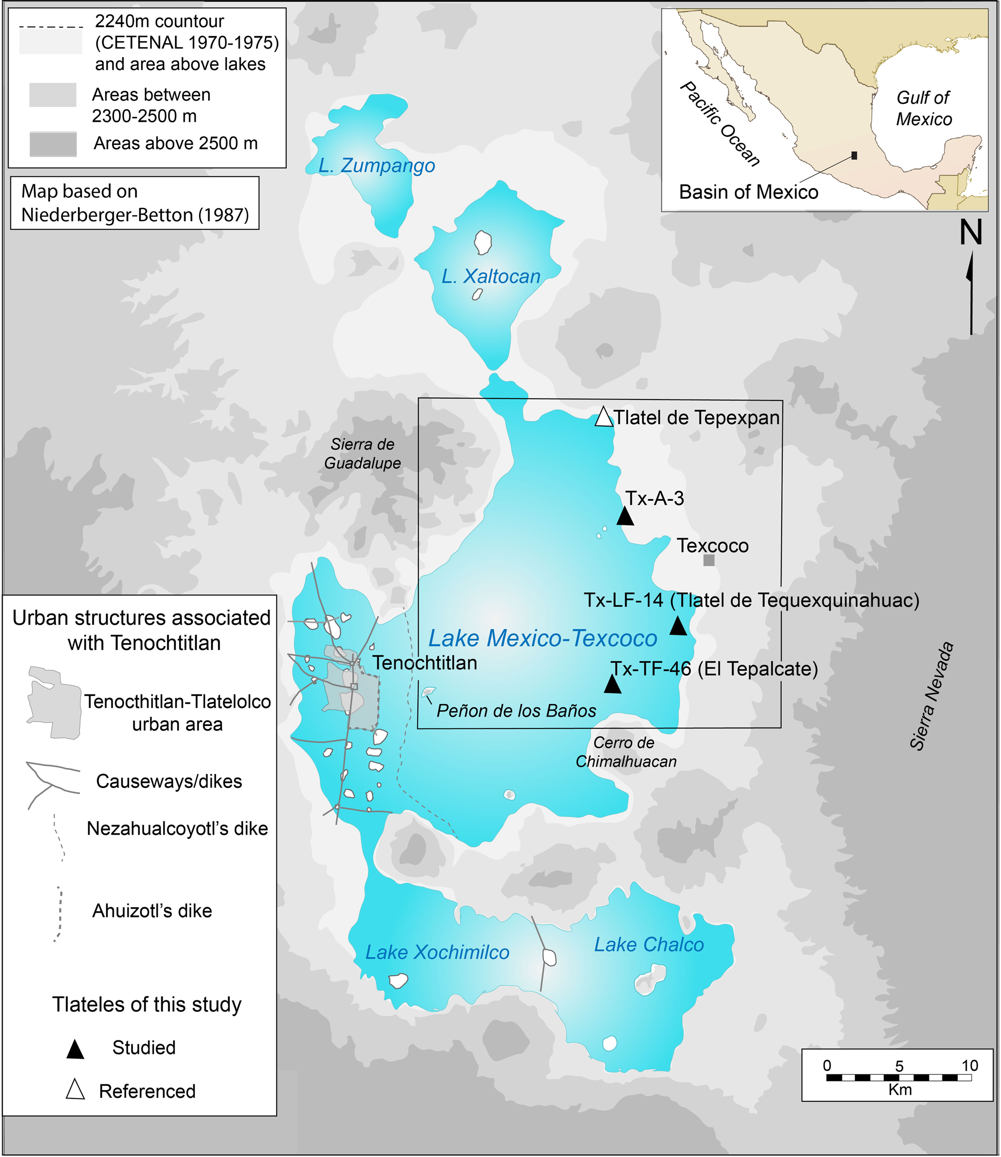
Figure 1. The lakes of the Basin of Mexico with the location of the focus area in this study in the eastern part of Lake Texcoco (see details in Figure 2). Map by Cordova, based on Niederberger-Betton (Reference Niederberger-Betton1987).
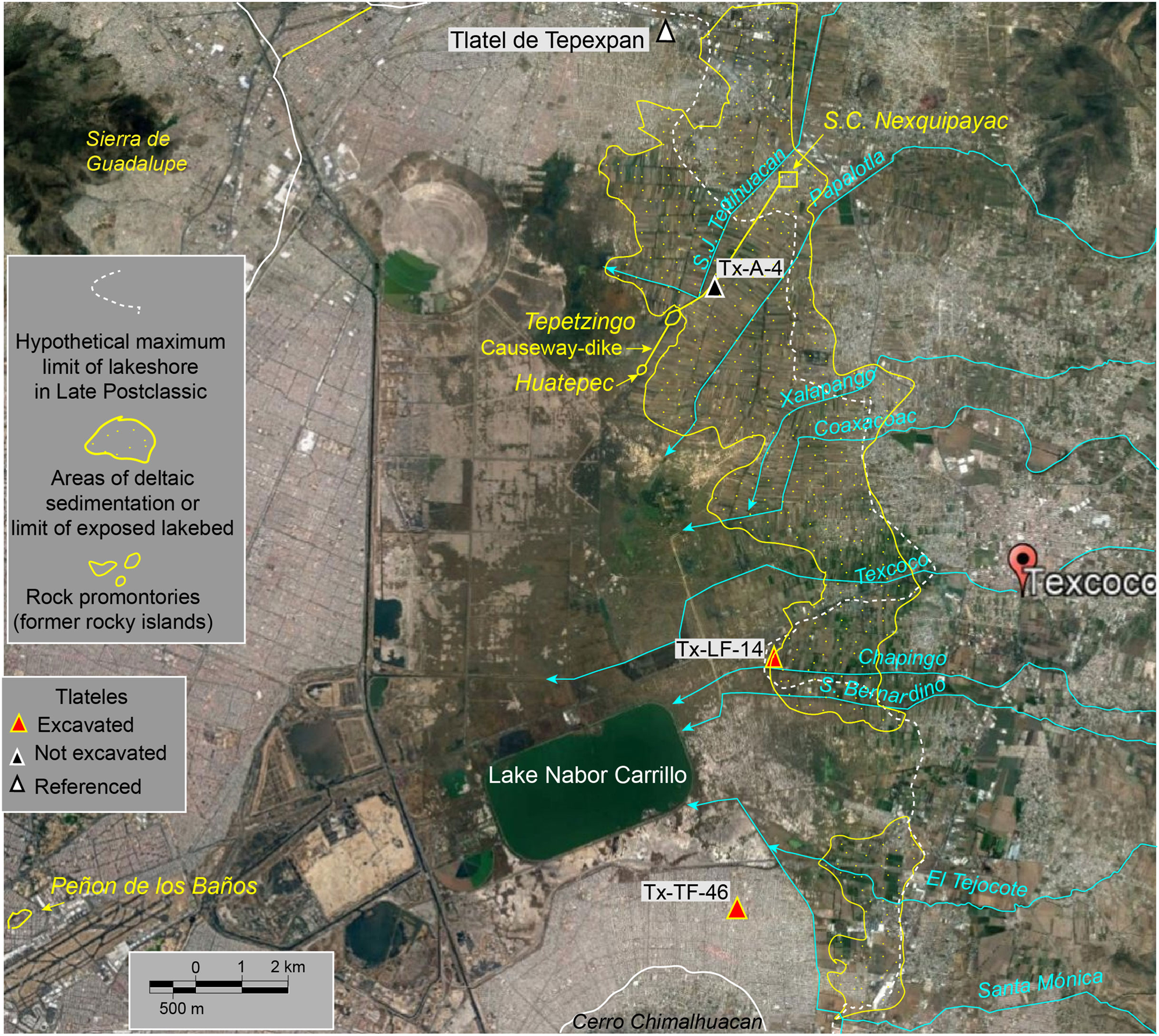
Figure 2. The eastern side of former Lake Texcoco in the context of the current urban sprawl and surviving lacustrine bodies, indicating the tlateles studied and referred to in the text. Courtesy of Google Earth.
The attraction to lacustrine resources in the context of demographic pressure led to the proliferation of insular settlements, which in some of the lakes merged with chinampas (raised fields in wetlands) to form extensive lacustrine settlement complexes (Armillas Reference Armillas1971; Sanders et al. Reference Sanders, Parsons and Santley1979). This process led to the further proliferation of lacustrine urban centers with Aztec Tenochtitlan as the largest of them (Calnek Reference Calnek1972; González-Rul Reference González-Rul1998; Luna-Golya Reference Luna-Golya2014; Morehart and Frederick Reference Morehart and Frederick2014).
Given their importance in the evolution of civilization in the lacustrine realm of the Basin of Mexico, the tlatel-type settlements have received attention from archaeologists. Most archaeological studies on tlateles, however, focus on their social and economic purposes, and to a much lesser extent on the environmental processes that accompanied their formation, occupation, and abandonment. Hence, to understand the role of tlateles in the development of the social and economic fabric in the lacustrine realm of the Basin of Mexico, it is necessary to address the environmental context of their formation.
The word tlatel derives from the Nahuatl tlaltelli (tlalli, earth; tetl, stone), which signifies an earthen mound (Molina Reference Molina1571), and in some instances a small island (López de Gómara Reference López de Gómara2006). Until recently, rural residents around the remains of the former Lake Texcoco refer to a mound in a flood-prone area as tlatel. The term entered the archaeological vocabulary of the Basin of Mexico archaeology in the mid-twentieth century to designate a small insular settlement often associated with salt procurement activities (Apenes Reference Apenes1943; Litvak-King Reference Litvak-King1964; Noguera Reference Noguera1943; Parsons Reference Parsons1971).
More recently, the term tlatel has appeared in the lexicon in geotechnical studies to designate areas under the urban areas of the Basin of Mexico where certain structural foundations (cimentaciones) indicate former insular occupation (Auvinet et al. Reference Auvinet, Méndez and Juárez M2017). Based on the references above, a tlatel is essentially the basic form of settlement on a lacustrine or palustrine bed, or an area with permanent or intermittent impoundment by water, regardless of its economic or social purpose.
Results from archaeological excavations in the areas of the former lakes of the Basin of Mexico show that tlateles had a diversity of purposes such as fishing and hunting stations, salt-making stations, as well as places for ceremonial functions and habitation (Apenes Reference Apenes1943; Gámez-Eternod Reference Gámez-Eternod and Vargas-Pacheco2005; Litvak-King Reference Litvak-King1962, Reference Litvak-King1964; McClung de Tapia and Acosta-Ochoa Reference McClung de Tapia and Acosta-Ochoa2015; McClung de Tapia et al. Reference McClung de Tapia, Serra-Puche and Limón de Dyer1986; Parsons Reference Parsons1971; Sanders et al. Reference Sanders, Parsons and Santley1979; Serra-Puche, Reference Serra-Puche1988). Other studies found that some tlateles merged with other tlateles and agricultural raised fields (chinampas), thus growing into large rural and urban occupation complexes (Armillas, Reference Armillas1971; Ávila-López Reference Ávila-López2006; Calnek Reference Calnek1972; Frederick et al. Reference Frederick, Winsborough, Popper and Brumfiel2005; González-Rul Reference González-Rul1998; Luna-Golya Reference Luna-Golya2014; Morehart and Frederick Reference Morehart and Frederick2014).
Despite the various studies, many questions about tlatel-type settlements remain unanswered. One question is whether tlateles are completely anthropogenic features or are associated with pre-existing natural features. Stratigraphic studies suggest that tlateles are in fact artificial islands built by accumulating earth and plant material from the lake and its shores (Armillas Reference Armillas1971; Frederick et al. Reference Frederick, Winsborough, Popper and Brumfiel2005; Litvak-King Reference Litvak-King1964). However, other studies exploring the geological stratigraphy and geomorphology surrounding lacustrine settlements in the Basin of Mexico have provided a basis for understanding the relation of tlateles to some geological features in the lacustrine and shoreline environment (e.g., Carballal-Staedtler and Flores-Hernández Reference Carballal-Staedtler and Flores-Hernández1989; Frederick and Cordova Reference Frederick and Cordova2019).
The formation of tlatel-type settlements in the context of geomorphic features and lacustrine dynamics is a productive step to answering other questions, particularly those referring to the permanent or seasonal occupation of tlateles and the stability of the lacustrine system that allows tlateles to grow into larger and more complex insular settlements.
In the context of the various aspects of tlateles mentioned above, this study addresses the stratigraphic information and geomorphological context for three tlatel settlements recorded in the Texcoco Archaeological Survey (Parsons Reference Parsons1971) in the eastern part of Lake Texcoco: site Tx-LF-14 (Tlatel de Tequexquinahuac), site Tx-TF-46 (Tlatel El Tepalcate), and the surveyed tlatel site Tx-A-4 (Figures 1 and 2). Additionally, stratigraphic information from the Tlatel de Tepexpan (Figure 1), excavated by Litvak-King (Reference Litvak-King1964), provides information to understand the general geomorphic and cultural regional context. With the information from these localities, this study correlates the formation and occupation of these four tlateles with regional paleoclimatic trends and the urban development of Aztec Tenochtitlan.
STUDY AREA
General Geographic Features
The study area corresponds to the eastern part of the former bed of Lake Texcoco (Figure 2). Situated between 2,236 and 2,242 m of elevation, the area is flat, sparsely vegetated, and conformed by clayey ground saturated with salts and prone to flooding during the rainy season (Ortiz-Solorio and Gutiérrez-Castorena Reference Ortiz-Solorio and Gutiérrez-Castorena2015).
Mean annual precipitation over the dry bed of the former Lake Texcoco is between 580 and 600 mm a year, concentrated in the months of May to October; and the mean annual temperature fluctuates between 15 and 16°C (Jáuregui-Ostos Reference Jáuregui-Ostos2000). The average minima and maxima occur in January (2–3°C) and April (27–28°C), respectively. Mean annual evapotranspiration for this area is about 500 mm a year (Gómez-Reyes Reference Gómez-Reyes2013), which is slightly lower than the annual precipitation. Despite the relatively low temperatures, evapotranspiration value is relatively high due to high elevation, high insolation, and dry winds (Jáuregui-Ostos and Vidal-Bello Reference Jáuregui-Ostos and Vidal-Bello1981)
Lake Texcoco was the largest and lowest of five lakes occupying an endorheic basin, i.e., the Basin of Mexico (Figure 1). Despite its size, the lake was a shallow body of water fed by rivers descending from the adjacent mountains, by the excess of water from the northern lakes (Zumpango and Xaltocan) and the southern lakes (Chalco and Xochimilco), and minor inflow from springs (Orozco y Berra Reference Orozco y Berra1864). Despite the incoming freshwater, the lake was saline due to the contribution of sodium and bicarbonate ions from rocks and springs, saline input from the northern lake Xaltocan, and excessive evaporation that concentrates salts in its waters and ground (Bradbury Reference Bradbury1989; Garay Reference Garay1888; Orozco and Madinaveitia Reference Orozco and Madinaveitia1941).
The waters of Lake Texcoco began to recede in the centuries following the Spanish conquest, particularly through the seventeenth, eighteenth, and nineteenth centuries, due to silting and the construction of works to drain the lakes out of the Basin of Mexico. At the beginning of the twentieth century, because of the construction of the Gran Canal del Desagüe and the tunnels of Tequixquiac, the lake shrunk to a series of interconnected and isolated ponds. By the beginning of the 2000s, the various small bodies of water were almost dry, with some areas of seasonal flooding and a series of artificial small lakes, of which Lake Nabor Carrillo was the most prominent (Figure 2).
Soils in most of the basin of the former lake are predominantly Solonchak, characterized by high salt content, high pH, and high clay content originating from lacustrine clay sediments (Ortiz-Solorio and Gutiérrez-Castorena Reference Ortiz-Solorio and Gutiérrez-Castorena2015). Soils in the alluvial/deltaic margins correspond to the various suborders of Vertisols and Entisols (Gutiérrez-Castorena and Ortiz-Solorio Reference Gutiérrez-Castorena and Ortiz-Solorio1999). Because the latter present lower salt content and more mixed textures, they are usually under cultivation. Their distribution is marked on the landscape by the extent of farming into the lakebed, indicating also the limit of the former deltaic surfaces (Figure 2).
Vegetation on the dry lakebed consists mainly of halophytic species, for example small shrubs such as romerito (Suaeda nigra) and grasses such as saltgrass (Distichlis spicata; Rzedowski Reference Rzedowski1957). In some localities, particularly along canals, the common aquatic vegetation includes cattail (Typha latifolia) and sedges (Schoenoplectus sp. and Cyperus sp.), which generally are referred to as juncales or tulares (Lot and Novelo Reference Lot and Novelo2004; Rzedovski Reference Rzedowski1957). Today, many non-native species thrive on the former lakebed, including halophyte shrubs such as Kochia scoparia, and small trees such as Tamarix plumosa, T. chinensis, and Cassarina equisetifolia, all introduced as means to protect the soil from deflation and serve as windbreakers.
Surrounding the salinized lakebed, vegetation is predominantly ruderal, particularly related to abandoned agricultural fields and areas of high disturbance, with various shrubs and trees, particularly exotic species such as Eucalyptus spp. and Schinus molle (pirul), generally bordering canals and roads. Disappearing, but once important in this area, is Taxodium mucronatum (ahuehuete), some of which still border old canals and roads.
The drying of the lake exposed numerous sites and scatters of cultural material, some of which were recorded by the Texcoco Archaeological Survey (Parsons Reference Parsons1971). At the time of this survey, the idea that the deepest parts of the lakebed were uninhabited discouraged archaeologists from extending the surveys into the interior. Nonetheless, later surveys of the dry beds of lakes Chalco, Xochimilco, Xaltocan, and Zumpango (Parsons Reference Parsons2008; Parsons et al. Reference Parsons, Brumfiel, Parsons and Wilson1982) revealed that the lakes were so shallow that settlements occurred throughout their entire surfaces. Thus, a more recent survey of the north-central part of Lake Texcoco revealed extensive scatters and features built for different purposes (Parsons and Morett Reference Parsons and Morett2004). Large parts of the dry lakebed, however, remain without survey coverage.
Stratigraphy
Layers of clay interbedded with silt, loam, sand, and tephra layers dominate the Late Pleistocene stratigraphy of Lake Texcoco, all of which conform to an informal stratigraphic unit known as Arcillas Superiores (Upper Clays; Mooser Reference Mooser2018; Santoyo-Villa et al. Reference Santoyo-Villa, Ovando-Shelley, Mooser, F. and León-Plata2006). The upper five meters of this unit consist of an olive-green clay, often referred to as bentonite in geologic and soil reports and jaboncillo by the locals.
Layers of volcanic ash appear interbedded with the clay and with other deposits above them. The most widespread is the Tlahuac Tephra (originally known as Great Basaltic Ash), which is an andesite basaltic-to-andesite tephra with ample distribution in the basins of lakes Chalco and Texcoco (Gonzalez et al. Reference González, Huddart, Israde-Alcántara, Domínguez-Vázquez and Bischoff2014, Reference Silvia, Huddart, Israde-Alcántara, Domínguez-Vázquez, Bischoff and Felstead2015; Ortega-Guerrero and Newton Reference Ortega-Guerrero and Newton1998; Ortega-Guerrero et al. Reference Ortega-Guerrero, del Socorro Lozano-García, Caballero and Herrera-Hernández2015). Dates originally varied between 26,000 and 34,000 14C years BP (Bradbury Reference Bradbury1989; Ortega-Guerrero and Newton Reference Ortega-Guerrero and Newton1998); its age is now centered on 28,690 cal yr BP (Lozano-García et al. Reference Lozano-García, Ortega-Guerrero, Roy, Beramendi-Orosco and Caballero2015). Younger tephras, such as the Tutti Frutti Pumice (dated 17.07 cal ka) and the Upper Toluca Pumice (dated ca. 12.3 cal ka), appear embedded in the uppermost lacustrine deposits, sometimes as original volcanic ash-fall deposits but also as reworked tephras (Gonzalez et al. Reference González, Huddart, Israde-Alcántara, Domínguez-Vázquez and Bischoff2014).
The uppermost lacustrine layers, probably dating to the terminal Pleistocene and Holocene, consist of green and brown clay, dark organic sediments, diatom layers, reworked ash, and sand, whose sequences are sometimes not consistent across the lakebed (Cordova Reference Cordova1997). These younger lacustrine deposits are completely missing in some parts of the lakebed, with the jaboncillo exposed directly on the surface. This unequal distribution of the surface layers suggests that topmost layers were removed by erosive processes at times when recession of the shallow lake occurred during prolonged dry periods.
The Areas of the Three Studied Tlateles
Site Tx-TF-46 (El Tepalcate) is located near the southeastern shore of the lake, north of the town of Chimalhuacan, now covered by urban development (Figure 2). Noguera (Reference Noguera1943) reported and excavated the site, Parsons (Reference Parsons1971) surveyed the site, Gámez-Eternod (Reference Gámez-Eternod1993, Reference Gámez-Eternod and Vargas-Pacheco2005) carried out additional excavations, and Cordova (Reference Cordova1997) did stratigraphic and sediment analyses. The latter project provided the stratigraphic and chronological information for this study.
Site Tx-LF-14 (Tlatel de Tequexquinahuac) is located west of the Autonomous University of Chapingo campus, south of the toll highway connecting Texcoco with Mexico City (Highway 136D), and north of the modern channel of the Chapingo River (Figure 2). The area today is idle land and prone to flooding. Parsons (Reference Parsons1971) reported the site and collected surface pottery and Morett-Alatorre et al. (Reference Morett-Alatorre, Sánchez-Martinez and Mirambell1999) excavated the site and provided information and ages that support this study. There are numerous other tlateles of similar nature and age in the broad area north and south of the canal carrying the waters of the Chapingo River, suggesting a large complex of settlements contemporaneous with the excavated site.
Tlatel Tx-A-4 is located west of the town of San Salvador Atenco and south of San Cristobal Nexquipayac, northwest of the Tepetzingo hill, and only 30 m east of the current channel of the San Juan Teotihuacan River (Figure 2). The site is located in part on the side of a road and former canal, and surrounded to the east by cultivated field. An abandoned brick kiln formerly associated with a brickyard nearby occupies the top of the tlatel. Parsons (Reference Parsons1971) reported the site, assigning it a Late Aztec age. As part of the present study, aspects of the geomorphology and stratigraphy of the area combine to place the site in a historical geomorphic context.
The previously excavated Tlatel de Tepexpan, on the northern shores of the former Lake Texcoco, serves here as a reference to place the studied tlateles in a broader geographic context (Figures 1 and 2). This tlatel, now completely covered by urban settlements, was located about 300 meters west of the well-known Tepexpan Man Site. According to the description of deposits in the area (De Terra Reference De Terra, Terra, Romero and Stewart1949), the tlatel stood directly on deposits of a former shallow body of water and a former undated shoreline. Litvak-King (Reference Litvak-King1964) excavated the site, determining three occupation phases associated with lake-level fluctuations, which are the subject of discussion in this paper. A pedostratigraphic sequence at the Tepexpan Man Site, suggests that during the late Holocene, the entire area was mostly dry, but with periods of substantial impoundment (Sedov et al. Reference Sedov, Lozano-García, Solleiro-Rebolledo, de Tapia, Ortega-Guerrero and Sosa-Najera2010).
METHODS AND SOURCES
Of the three studied tlateles, Tx-TF-14 and Tx-LF-46 were properly studied though survey and excavation. Tlatel Tx-A-4 was surveyed and stratigraphic data were obtained from a brickyard pit nearby. The site named Tlatel de Tepexpan, now completely obliterated by urban development, was not directly studied, but information from its original landscape and regional stratigraphy (De Terra Reference De Terra, Terra, Romero and Stewart1949) and excavation (Litvak-King Reference Litvak-King1964) were useful for its placement in the context of the three studied sites.
This study focuses on information concerning the relation between cultural and natural deposits and their geomorphological context, an approach that involves stratigraphic description and correlation and the study of modern and buried landforms. The stratigraphic work consisted first in determining stratigraphic zones, discrete sediment depositional units referred to here as zones. Such zones include apparently natural deposits (e.g., lacustrine, beach, and sand), pedogenically modified sediments (i.e., soils), and cultural deposits and features. Stratigraphic zones are numbered with Arabic numerals. In the case of site Tx-TF-46 (sections TPL-2, 3, and 4), however, layers are designated with Roman numerals, as they were used in the archaeological excavation. Section TPL-1, a geological section, carries Arabic numerals.
The study of landforms included direct observation and mapping on the surface, through historical aerial photography, and paleosurfaces exposed in trenches. In the case of site Tx-A-4, early colonial maps and documents were useful in verifying natural and cultural features on the surface. Additionally, the location of the sites in the broader context of modern features and elevations also provided clues to the landform units associated with the sites.
Relative dating involved the use of diagnostic ceramic seriation obtained from excavations and surface. Absolute dating was obtained through accelerator mass spectrometry radiocarbon assays, three from the context of site Tx-TF-46 and two from the context of Tx-LF-14 (Table 1). Radiocarbon ages were calibrated using the online CALIB software by Stuiver and Reimer (Reference Stuiver and Reimer1993) and applying the intCal13.4c curve (Reimer et al. Reference Reimer, Bard, Bayliss and Warren Beck2013). Calibrated ages are reported here in 1- and 2-sigma ranges cal b.c./a.d. (Table 1). Stratigraphic and chronological diagrams, however, display only the maximum and minimum sigma-1 calibrated ages.
Table 1. Radiocarbon assays, provenience, and calibrated age ranges.

RESULTS
Site Tx-TF-46 (El Tepalcate)
Before its obliteration by urban settlement, the site was easily identifiable as an elongated landform extending along a WSW-ENE direction (Figure 3). The mound had an asymmetric profile across, with its north and east sides having a slightly steeper slope than the other sides (Figure 3 and Figure 4, main profile). A scarp measuring between 10 and 30 cm tall, suggestive of a prominent mark of wave erosion, extended parallel to the sand ridge (Figure 3a and Figure 4, main profile). On top of the mound, a grey sandy ridge ran along the same direction of the mound's length, merging with another ridge running perpendicular along the eastern side of the mound (Figure 3).
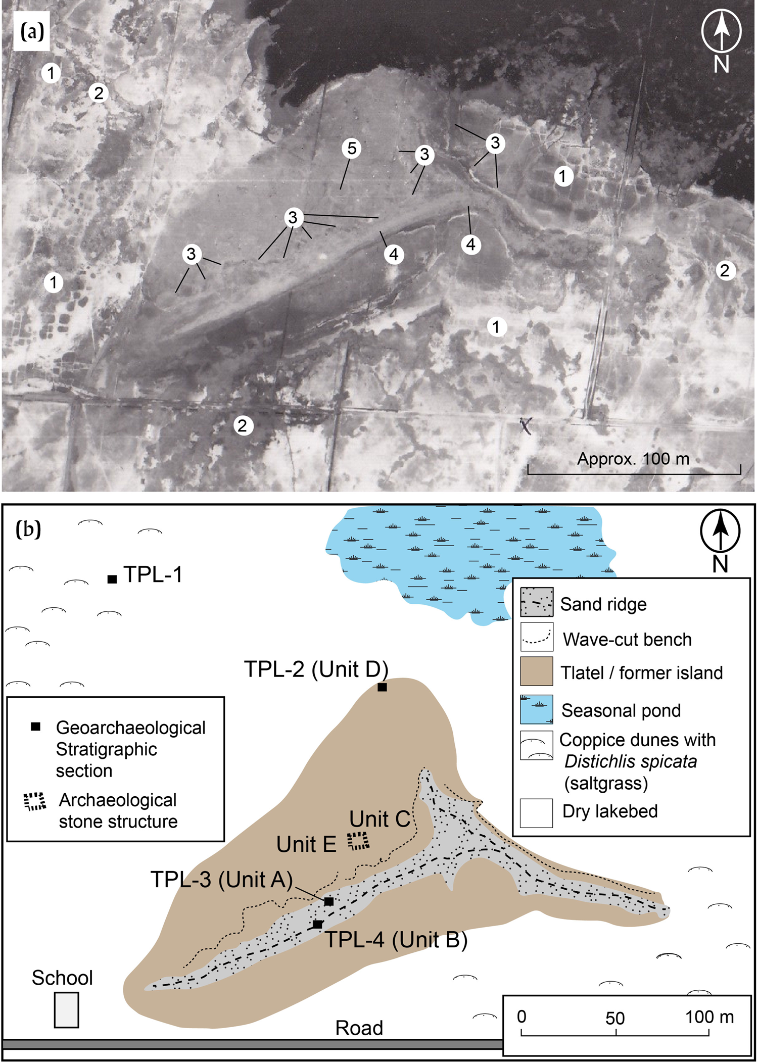
Figure 3. Tlatel El Tepalcate (Site Tx-TF-46). (a) 1980 air photograph: (1) hydraulic cracks on exposed lakebed; (2) coppice dunes; (3) wave-cut benches; (4), sand ridge; and (5) location of architectural structure (Compañía Mexicana de Aerofoto). (b) Sketch of site at the time of research (1993) with the location of stratigraphic sections. Drawing by Cordova.

Figure 4. Site Tx-TF-46 (El Tepalcate). Main profiles and stratigraphic sections.
The majority of the diagnostic ceramics on surface and from excavation were Terminal Formative (ca. 190 b.c.–a.d. 250), corresponding mainly to the Patlachique phase (150–1 b.c.; Rattray Reference Rattray2001), though ceramics of early and later phases appeared in smaller amounts (Gámez-Eternod Reference Gámez-Eternod and Vargas-Pacheco2005). Diagnostic ceramics on the sand ridge were rare but encompassed mostly Late Aztec (ca. a.d. 1300–1520) and Texcoco fabric-marked ceramics. North of the wave-cut bench, materials tended to mix with the majority still corresponding to the Terminal Formative. Many of those ceramics on the surface, particularly on the north side, had damage by wave reworking.
On-site and off-site stratigraphic sections show that the base of the tlatel lies directly on lacustrine deposits of Holocene age represented by layer I in Section TPL-1 and layer IV in section TPL-2 (Figure 4). The lowermost cultural deposit lies directly on a layer of cattail (Typha latifolia). The age of the cattail leaves (82–37 cal b.c.) provides a tentative age for the earliest establishment of the Terminal Formative occupation on the lacustrine bed.
The series of cultural deposits corresponding to the Terminal Formative appeared in sections TPL-2 (layers I–IIb), TPL-3 (layer IV), and TPL-4 (layer IV). The excavation of unit C exposed a pyramidal structure, the base of which produced a 1-sigma date in the range of 2–210 cal a.d. (Figure 4), and a 2-sigma range of ca. 94 b.c.–a.d. 256 (Table 1).
The sandy ridge deposits at the top of the tlatel at site Tx-TF-46 were composed of two main sedimentary facies. The lower part of the ridge facing north had a series of units of coarse and medium sand and small gravel imbricated in the cross-bedding typical of beach deposits, corresponding to layers IIa, IIb, and III in section TPL-3 and layer III in TPL-4 (Cordova Reference Cordova1997). The beach deposit consists mainly of coarse sand and small gravel, with abraded fragments of ceramics and lithics reworked from the tlatel's cultural deposits. The aerial distribution of the sand ridge (Figure 3) suggests that the sand may originate from fluvial sediments carried by longshore currents.
The top and southern part of the ridge facing south was composed mainly of medium sand and silt, corresponding to layers Ia and Ib in TPL-3 and layer II b in TPL-4. Grain-size distribution suggests that this layer is probably aeolian, corresponding perhaps to the redeposition of beach sand behind the mound in combination with pellets of clay removed from the lakebed, that is to say the same as the source of the coppice dunes around the site (Cordova Reference Cordova1997). The location of this aeolian feature, on the south side only, corresponds to the dominant winds in the Basin of Mexico, which are usually from a northern and northeastern direction.
Site Tx-LF-14 (Tlatel de Tequexquinahuac)
Site Tx-LF-14 forms an elongated topographic feature of no more than a meter and a half above the surrounding plain (Figure 5). Surface archaeological materials appear in clusters at various points on the highest parts of the site, whereas in other areas they lie below recent alluvial silt. Ceramic fragments on the surface bear marks of wave reworking. Algal coatings on surface materials also suggest that ceramics lay underwater for some time.

Figure 5. Site Tx-LF-14 (Tlatel de Tequexquinahuac), topographic model, reticula, and location of long stratigraphic section. Contours are in decimeters. Arrows indicate direction of paleochannels. Redrawn after Luis Morett and Charles Frederick by Cordova.
Although several squares within the site were excavated, most of the general stratigraphy was obtained from a north-south trench across the site (Figure 5). The trench exposed the natural and cultural stratigraphy and landforms (Figure 6) reaching the Late Pleistocene Tlahuac Tephra, which is in turn overlain by green lacustrine clays (locally known as jaboncillo) and a paleosol of uncertain age. Directly over the soil lie the late Holocene alluvial and beach deposits associated with the formation of the site (Figure 6). In the zone near the channel the alluvial deposits lie directly on the Tlahuac Tephra (Figure 6, profile 1), suggesting that previously a channel scoured deeper into the Pleistocene lacustrine clays.

Figure 6. General stratigraphy section across the southern side of site Tx-LF-14.
The alluvial deposits consist of the channel, levees, and splays, which grade into beach deposits to the south. A sequence of peat and sand fill in the channel, suggesting alternate periods of stagnation and alluvial activity. A levee bordering the channel presents a series of accreted alluvial and beach deposits which conform to most of the structure of the tlatel (Figure 5).
The cultural occupation of the site is associated with the levee, the accreted alluvial deposits, and beaches (Figure 7). The occupation layers contain abundant ceramics and lithics, hearths, pits, and wooden stakes. The ceramic materials from the occupations and refuse deposits are almost exclusively within the diagnostic ceramic phases of the Late Formative period (ca. 550–200 b.c.), which is backed up by the ranges of two radiocarbon dates at two occupation levels (Figure 7, profile 2). The channel ridge, which bears most of the occupations elsewhere in the site (Morett-Alatorre et al. Reference Morett-Alatorre, Sánchez-Martinez and Mirambell1999), aligns with the paleochannel.

Figure 7. Stratigraphic profiles at Tx-LF-14 (see their stratigraphic context on Figure 6).
Above the scoured Pleistocene surface, a deltaic distributary channel accumulated sediments to form a levee that grew vertically, likely during the late Holocene. Thus, the initial occupation of the site appears to have occurred on the levee (Figure 6). Subsequently, the channel of this arm of the delta abandoned its course, then becoming a deposit of stagnating water where peat accumulated (Figure 7, profile 1). Layers of alluvium appear embedded in the peat, suggesting that the abandoned channel was occasionally flooded. Peat and sediment accumulation within the channel occurred in concomitance with occupation of the levees (Figure 7, profiles 2 and 3). Subsequently the side of the levee shifted to sand beach aggradation (Figure 7, profiles 4 and 5).
The bedding of beach deposition formed sigmoidal accretionary wedges, often containing abundant reworked artifacts, ash, and charcoal in secondary context. This emplacement suggests that the accretion of the beach deposits occurred while the levee remained occupied. Cultural materials in primary context near profile 4 (Figure 6), however, show evidence of a short-lived occupation of the beach.
The progradation of the beach deposits resulted probably by sand supplied by other arms of the delta nearby, longshore sediment currents, and waves, concurrent with a transgressive phase of the lake. Eventually, the rising lake inundated the levee ridge, making it uninhabitable. As the lake reached the top of the ridge, waves destroyed any positive relief cultural deposits and caused abrasion on the surface ceramics. Subsequently, low-energy alluvium, represented by the yellow silt accumulated at the very top (Figure 6), obscuring the ancient alluvial and beach landforms, leaving only the topmost areas of the site exposed to the surface.
Tlatel Tx-A-4
Site Tx-A-4 is a mound occupying the plain east of the present artificial channel of the San Juan Teotihuacan River (Figure 8). Parsons (Reference Parsons1971) reported only Late Aztec ceramics (i.e., Aztec III and III–IV). The total lack of Texcoco fabric-marked ceramics suggests that the site was not a salt-making station (Parsons Reference Parsons1971). The construction of a road on an apparent old structure, seemingly a dike, (Figures 8 and 9a) disturbed part of the western side of the mound.

Figure 8. Area of site Tx-A-4. Location and landscape context around the tlatel, brickyard, and geomorphological profiles (see Figure 9; Topographic map, Instituto Nacional de Estadística e Informática. 1:25,000; Google Earth Image). Note: Cerro de San Miguel is also known as Tepetzingo (see Figure 2).

Figure 9. Geomorphic and stratigraphic features around Tx-A-4. (a) Profile across the site, and (b) profile across a brickyard. See locations of profiles in Figure 8.
A map accompanying a land litigation document dated to a.d. 1593 shows the dike running from San Cristobal Nexquipayac to San Francisco Tepetzingo, at the northern foot of the hilly island (Archivo General de la Nación 1593). The dike (albarrada in the document) coincides with the road passing next to the site (Figure 8). The erosion of the roadbed on its west side exposes fragments of stucco and rocks, presumably the remains of the ancient dike. The aforementioned 1593 map shows several settlements on the plain, but none could be identified with site Tx-A-4. East of the dike, the map shows an area of sementeras (sown fields) with lines of cultivated plants bordered by ample water lines (canals?) running east–west. Farther south of the cultivated fields lies the shoreline existing at that time. Today the plains surrounding the tlatel and west of the former dike-road consist of cultivated alluvial soil. Because no Pre-Hispanic and Colonial archaeological materials appear on the surface, this alluvium is of recent age.
A brickyard pit north of the site (Figure 9b) exposes a sequence of recent deposits west of the presumed dike. At the bottom of the sequence appears a light green lacustrine clay (zone 7) capped by a loam sediment of platy structure, possibly a layer of tequesquite (a mineral evaporitic layer consisting of sodium chlorates and carbonates; zone 6). On top of the tequesquite surface lies a loamy dark brown sediment (zone 5), overlain by a light brown laminated deposit with thin layers of alternating silt and sandy loam (zone 4). Above this deposit lies a sequence of cumulic overbank alluvial layers with poorly developed soil with roots marks, pores, and worm casts (zone 3). In a poorly defined transition to this layer lies a massive deposit of silt, probably a plowed alluvial soil (zone 2). The topmost layer (zone 1) is a disturbed deposit with fragments of brick (zone 1) discarded from the nearby brick factory.
After Parsons (Reference Parsons1971) surveyed and reported the site, brickmaking activities were evidenced by a pit on the north side of the mound at site Tx-A-4. The pit provided raw sediment for brickmaking using the oven that still stands on top of the mound. Although the pit is now closed, evidence of archaeological material forming the northern edge mound supports the Late Aztec occupation and the lack of Texcoco fabric-marked ceramics. The material excavated from the pit also includes fragments of sediment that lay below the mound, among which are the green clay, equivalent to the green clay (zone 7) at the bottom of the brickyard sequence (Figure 9b). Above this green clay at site Tx-A-4, a dark peaty deposit formed, in direct stratigraphic association with the construction of the tlatel.
Interestingly, the peaty deposit found below the mound is missing at the section of the brickyard west of the former dike, where instead a dark brown low-energy sediment (zone 5) deposit occupies its equivalent stratigraphic position. Thus, the peaty deposit likely formed inside the area contained by the dike.
The sequence of historic alluvial deposits (zones 1–4 in the brickyard) is similar on both sides, indicating the Colonial and recent alluvial sediments that form the soils now farmed. The color and texture of the sediment of zone 4 have a strong resemblance to sediments of the Colonial alluvial stratigraphic unit E in the alluvial plains of Texcoco (Cordova Reference Cordova2017) and the progradation sediments of the seventeenth-century delta of the Amecameca River (Frederick and Cordova Reference Frederick and Cordova2019). Zones 2 and 3 are probably sediments produced by recent flooding and plowing. Zone 3, in particular, seems to be sediment laid by deliberate flooding to enrich the soil as documented in this area in recent times (Parsons Reference Parsons2001). Such practice, known in Spanish as entarquinado, was a common way to manure fields around the lakes of the Basin of Mexico in Colonial times (Candiani Reference Candiani2014).
DISCUSSION
Tlatel Development in Relation to Regional Precipitation and Lake-Level Fluctuations
The occupations of sites Tx-TF-46 and Tx-LF-14, both occurring in spatial and temporal proximity to each other, appear to have a sequential relation regarding lacustrine level fluctuations (Figure 10). In turn, their phases of occupation and abandonment correlate with changes in lacustrine and fluvial activity and trends in regional precipitation (Figure 11).
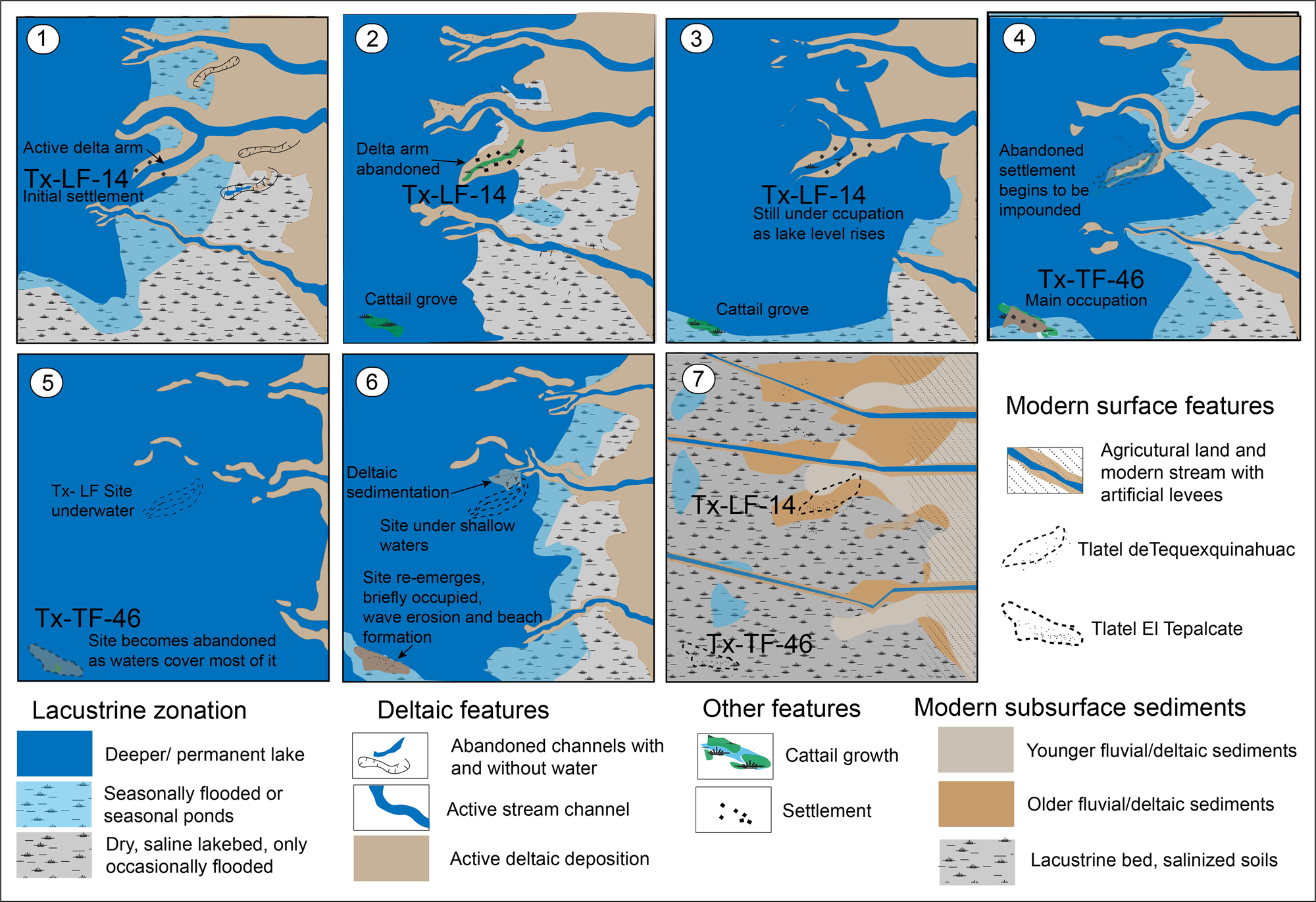
Figure 10. A reconstructive model (not to scale) of sites Tx-LF-14 and Tx-TF-46 at different stages during occupation and abandonment in relation to changes in their lacustrine surroundings. See Figure 11 for the climatic context of each stage.

Figure 11. Chronological development of the studied tlatels in relation to regional precipitation reconstruction. (a) Occupation phases at Tlatel de Tepexpan (Litvak-King Reference Litvak-King1964). (b) Development of tlateles researched in this study and their elevation ranges, with occupation periods based on diagnostic ceramics and AMS dates (1-sigma ranges). (c) Regional cultural chronology (Parsons Reference Parsons1971; Parsons et al. Reference Parsons, Brumfiel and Hodge1996). (d) Phases of construction of Tenochtitlan and western Lake Texcoco (Lachniet et al. Reference Lachniet, Bernal, Asmerom, Polyak and Piperno2012; this work). (e) Projected times of delta advance over lakebed (this work). (f) δ18O scores as proxy for May–October precipitation from isotopic data from Juxtlahuaca speleothems (Lachniet et al. Reference Lachniet, Asmerom, Polyak and Bernal2017). (g) δ18O obtained from sediments in lake maar Aljojuca, Oriental-Serdan Basin (Bhattacharya et al., Reference Bhattacharya, Byrne, Böhnel, Wogau, Kienel, Lynn Ingram and Zimmerman2015).
The landscape depicted in vignette 1 (Figure 10) represents the initial settlement at Tx-LF-14, perhaps in the late Middle Formative or early Late Formative, coinciding with relatively low lake levels, which allowed an arm of a deltaic system to jut out east into the lakebed. Subsequent changes in the delta led to the abandonment of the arm where the settlement sat as lake levels began to rise (vignette 2). The abandonment of the deltaic channel lead to the filling of the channel with peat and lenses of alluvium (Figure 6 and profile 1 in Figure 7). Perhaps the stability of the abandoned channel stimulated the further settlement as the former channel levees became more stable.
A lake-level rising trend began to isolate the levees of the former deltaic arm (vignette 3), while beach sand accumulated on its side. However, the occupation of the site continued on the levees (Figure 6 and profiles 2– 5 on Figure 7). The beaches were probably unstable for permanent occupation, except for a brief lower lake stage, which may correspond to the drier period that appears to have occurred between 550 and 450 b.c. (Figure 11g). While this happened, Tx-TF-46 (El Tepalcate) may have been a relatively higher area of the lakebed with cattail groves most likely associated with a freshwater spring.
As lake levels continued to rise, lake waters impounded the levee at site Tx-LF-14, subsequently making it uninhabitable. At the same time, occupation at site Tx-TF-46 began on the cattail grove, where settlers deliberately accumulated sediment and rock to cope with the increasing lake levels. The accumulation of anthropogenic deposits may have continued in the early centuries of the first millennium a.d., as atmospheric moisture increased lake levels (Figures 11f and 11g), leading to the transgression that peaked during the Early Classic. Thus, in the first or second millennium a.d., Tx-TF-46, was abandoned as waters impounded the site (Figure 10, vignette 5).
During Terminal Formative–Early Classic transgressions, other tlateles were occupied, for example the Tlatel de Tepexpan (Litvak-King Reference Litvak-King1964), located at much higher elevation than Tx-TF-46, a substantial occupation in the Classic occurred (Figure 11). A subsequent minor occupation during the Early Toltec and relatively more substantial one in the Late Aztec seem to coincide again with higher lake levels (Figure 11).
The effects of subsequent lake-level changes, during the lake-level drop caused by prolonged droughts during the Epiclassic and the Late Toltec–Early Aztec (Figure 11) are difficult to determine at sites Tx-TF-46 and Tx-LF-14, as no evidence for occupation or accumulation of sediments was present. These sites presumably remained underwater during high lake levels or remained exposed away from the shore during the extremely low levels, with abrasion of their surface materials at intermediate lake levels.
The only other time that some tlateles were reoccupied is the late Postclassic (i.e., Late Aztec period), where less-permanent occupations appear at Tx-TF-46 (Figure 10, vignette 6), probably associated with salt production. Higher lake-level stands may have eroded the mound and formed the sandy ridge. At the same time, at Tlatel de Tepexpan salt production accounted for the latest occupation of the site (Litvak-King Reference Litvak-King1964). No occupation, however, occurred at Tx-LF-14, as it remained underwater because of its low elevation.
During the Late Aztec, the area around Tx-A-4 may have received freshwater from the incoming San Juan Teotihuacan and Papalotla rivers, as suggested by the highly organic sediment in the area. Therefore, the construction of the dike connecting the settlement of Nexquipayac (probably a tlatel) and the insular hills of Tepetzingo and Huatepec served also as protection against saline water incursions. The attribution of this work to King Nezahualpilli (reigned a.d. 1473–1515; Archivo General de la Nación 1593) and the dominance of Late Aztec ceramics support the idea that the construction of the dike coincided with the lake-level rise towards the end of the Aztec Pluvial (Figure 11f).
During the Colonial period, the deltas advanced due to strong sedimentation and the gradual recession of the lakes. Sedimentation at this time may account for the yellow silts in some parts of Tx-LF-14 (Figure 6), and the yellow laminated silts (Figure 9b, zone 4) in the area of Tx-A-4. Site Tx-TF-14, however, did not undergo sedimentation, as it remained far from deltaic influence (Figure 2).
The Studied Tlateles in the Context of Regional Settlement Ecology of Lake Texcoco
In addition to augmenting our understanding of the settlement dynamics of the lacustrine and fluviolacustrine systems of the eastern part of Lake Texcoco, the results of this study provide proxy information for projecting lake-level changes to other parts of the lacustrine basin, including the area occupied by the urban complex of Aztec Tenochtitlan (Figure 1).
Unlike the eastern part of the lake, the western part is practically out of reach of archaeological surveys. Nonetheless, salvage archaeological excavations have yielded some relevant information about some of the dikes, islands, or large tlateles and the relation between original islands and the insular urban development of Tenochtitlan-Tlatelolco (Calnek Reference Calnek1972; Flores-Hernández and Carballal-Staedtler Reference Flores-Hernández and Carballal-Staedtler2004; González-Rul Reference González-Rul, Serra-Puche and Navarrete-Cáceres1988, Reference González-Rul1998).
A recurrent fact reported in most salvage archaeological reports from the western part of Lake Texcoco is the existence of sand and sandy loam deposits lying between lacustrine clay and Late Aztec settlement. Many of such sandy deposits seem to be beach or alluvial deposits associated with Aztec II ceramics and Texcoco fabric-marked ceramics (Carballal-Staedtler and Flores-Hernández Reference Carballal-Staedtler and Flores-Hernández1989; González-Rul Reference González-Rul, Serra-Puche and Navarrete-Cáceres1988). The Aztec II pottery, roughly eleventh to thirteenth centuries (Gorenflo and Garraty Reference Gorenflo, Garraty, Nichols and Rodríguez-Alegría2016; Parsons et al. Reference Parsons, Brumfiel and Hodge1996), coincides with the relatively low lake levels suggested by the decrease in moisture (Figures 11f and 11g).
Based on the recurrent stratigraphy described above, it is possible that the urban complexes of Tlatelolco and Tenochtitlan, as well as their surrounding insular settlements, were built on natural features and sediment shoals produced by the westward progradation of deltaic systems during the dry conditions of the centuries between the Classic and the Aztec pluvials (Figure 11). Excavations in the former island of Tlatelolco produced small amounts of Toltec and Early Aztec pottery (González-Rul Reference González-Rul1998), suggesting occupation perhaps during the dry phases. Coincidentally, the name Tlatelolco suggests relation with the word tlatel, although its original name in ethnohistoric sources was Xaltelolco (point of sand; Torquemada Reference Torquemada1975:bk. 3, ch. 23, p. 399). In contrast to the emplacements where Aztec II ceramics are found, the Aztec III pottery across Mexico City, coincident with the growth of Tenochtitlan, are more often associated with organic-rich deposits upon which settlers built chinampas (cf. González-Rul Reference González-Rul1998).
Following the hypothesis suggested by Lachniet et al. (Reference Lachniet, Bernal, Asmerom, Polyak and Piperno2012, Reference Lachniet, Asmerom, Polyak and Bernal2017), the lake-level rise during the late 1300s and 1400s may have caused some of these islands to flood, leading to the islands being upgraded with materials and dikes and resulting in the Tenochtitlan known to the first Europeans in the early 1500s. Accordingly, the construction of dikes and impoundment of freshwater was a response to the rising lake levels, a development compared with the small-scale case of the area around site Tx-A-4, where the construction of the dikes prevented the invasion of saline water and took advantage of water derived from the San Juan Teotihuacan and Papalotla rivers. In this situation it is very interesting to see that dikes connected islands, some of which were artificial (i.e., tlateles), suggesting also that perhaps many of the original settlements of Tenochtitlan developed out of tlateles grounded on particular natural features (i.e., elevated lakebed, springs, cattail groves, or even deltaic channel levees).
In summary, the natural and cultural events that occurred at the three tlateles discussed here provide a mirror to changes that may have affected the populations living at the same time on the western part of the lake, where the city of Tenochtitlan and its satellite islands developed into an urban conglomerate.
CONCLUSIONS
In the Basin of Mexico, a tlatel was a basic form of elevated settlement established in lacustrine and palustrine environments with the purpose of facilitating lacustrine resource exploitation that over time evolved into larger settlements in association with chinampas, dikes, and platforms. Within this broader concept of tlatel settlement, this study analyzed the origin and evolution of three tlateles in the saline, shallow, and highly dynamic environment of Lake Texcoco.
The stratigraphy and geomorphic context of the three prehistoric settlements in this study provide information on the diversity of lacustrine environments where tlatel-type settlements were suitable for a variety of activities associated with lacustrine and wetland environments. Site Tx-LF-14 (Tlatel de Tequexquinahuac) occupied a deltaic arm of the Chapingo River for most of the Late Formative period (550–200 b.c.). This tlatel corresponds to the type that builds up by natural accumulation of sediment (i.e., alluvium on a levee) in concomitance with human occupation surfaces. Its termination as a settlement occurred when lake levels rose over the levees.
Site Tx-TF-46 (Tlatel El Tepalcate) occupied an open-lake area where it grew on a cattail grove associated with a spring and possibly a deeper tectonic structure. Established during the Terminal Formative (200 b.c.–a.d. 250) when lake levels began to increase, the site was dedicated to salt processing and habitation. The eventual lake-level rise that occurred during the Early Classic (ca. a.d. 250–500) made the site uninhabitable, reemerging only as a mound on a dry plain during the Epiclassic to Early Aztec as the lake receded. Its brief reoccupation during the Late Aztec period high stand suggests that it occupied a shoreline and was dedicated to salt production, as well as possibly fishing and hunting. This tlatel is an example of one occupying a former natural feature, but unlike Tx-LF-14, its construction through accumulation is almost completely artificial.
Site Tx-A-4 is a tlatel built on the lakebed and associated with a dike protecting a freshwater bay from saline waters of a rising lake-level phase during the Late Aztec period. The bay formed between two deltaic systems and was fed by the freshwaters of the Papalotla and San Juan Teotihuacan rivers. The tlatel at this site is also an apparently artificial mound upgraded to rise above the water level.
Finally, the stratigraphy and geomorphological context of tlateles situated in the eastern part of the lake, still free of urbanization, could serve as proxies of settlement and water management infrastructure, no longer possible in the heavily urbanized part of the former lake. In particular, the number of tlateles and structures from the thirteenth to the sixteenth centuries could serve as proxies that correlated to those in the area of Tenochtitlan (west part of the lake).
RESUMEN
En las zonas de los antiguos lagos de la Cuenca de Mexico, un tlatel era un tipo de asentamiento asociado a la explotación de los recursos lacustres. El presente estudio investiga la estratigrafía y los contextos geomorphologicos de tres tlateles en la parte oriental del vaso del ex-lago de Texcoco con el fin de correlacionar sus fases de ocupación con cambios climáticos que afectaron los niveles lacustres desde aproximadamente entre los siglos VIII a.C. y XIV. Los tres tlateles estudiados corresponden a los sitios Tx-LF-14 (Tlatel de Tequexquinahuac), Tx-TF-14 (El Tepalcate), y Tx-A-4. Los resultados de esta investigación indican que el establecimiento de tlateles estaba muy relacionado a la sedimentación fluvio-lacustre (o deltaica), la distribución de manantiales de agua dulce en el lecho lacustre, y los cambios de niveles lacustres estacionales y a largo plazo, en el cuerpo de agua hipersalino y extremadamente cambiante del Lago de Texcoco. Algunos de los cambios identificados en los sitios estudiados coinciden con el desarrollo de otros asentamientos y procesos lacustres en otras partes del lago de Texcoco. Los resultados de esta investigación sugieren que la estratigrafía y contexto de los asentamientos lacustres en la parte oriental del lago de Texcoco, todavía en gran parte libre de aglomeraciones urbanas, puede ser útil como aproximación a la interpretación de los cambios lacustres anteriores y durante el desarrollo de los islotes artificiales que formaron Tenochtitlan.


