


Introduction
A pronival (protalus) rampart (Shakesby Reference Shakesby1997) is a ramp or ridge of debris formed at the downslope margin of a snowbed or firn field. Supranival transport of debris has traditionally been assumed to be the simplest source of material for the rampart (Shakesby Reference Shakesby1997). In areas where seasonal or permanent snow lies at the base of a cliff, mass-wasting of debris from a free-face falls on to a snow surface and slides, bounces and rolls across the snow to rest at the downslope fringe of the snowbed. Through time, debris accumulates, and when the snow melts a ridge or ramp of slope material is left at some distance from the cliff face.
Until the mid-1980s, research into pronival ramparts focussed on inactive examples (Shakesby Reference Shakesby1997). Since then, studies of actively-forming ramparts have improved the understanding of origin, morphology and mechanisms contributing to growth, clarified terminology, and determined rampart positions in relation to snowbeds and talus slopes (e.g. Ono & Watanabe Reference Ono and Watanabe1986, Harris Reference Harris1986, Ballantyne Reference Ballantyne1987a, Reference Ballantyne1987b, Shakesby et al. Reference Shakesby, Matthews and McCarroll1995, Reference Shakesby, Matthews, McEwan and Berrisford1999, Hall & Meiklejohn Reference Hall and Meiklejohn1997). In particular, a diverse range of supranival and subnival mechanisms of debris transport have been identified as potential contributors to rampart formation. Owing to its apparent simplicity, the actual manner of rampart genesis has, however, received relatively little attention. Nevertheless, four modes of origin are recognized by Curry et al. Reference Curry, Walden and Cheshire2001, namely 1) a wholly pronival (protalus) rampart, 2) glacial, 3) landslide, and 4) protalus rock glacier origin, all with subsequent pronival development.
Ballantyne & Kirkbride (Reference Ballantyne and Kirkbride1986) proposed the only general model of rampart genesis, derived from supposed exemplar or ‘unequivocal’ fossil features in the United Kingdom. The model describes gradual and continuous accumulation of intermittent rockfall debris on the downslope margin of a snowbed with mass-wasted debris from upslope accumulating at the rampart crest and down the distal (downslope) section. Subsequent growth in snowbed size enables material to be constantly added to the debris crest facilitating the downslope extension of the rampart with the distal slope maintained at the angle of repose for the debris. However, some ramparts have been found to have distal slopes that are not at repose, or where accumulation has occurred on the proximal (upslope) slope of the rampart (e.g. Harris Reference Harris1986, Pérez Reference Pérez1988, Grab Reference Grab1996). The actively-forming rampart found on Marion Island, appears to differ from the model proposed by Ballantyne & Kirkbride (Reference Ballantyne and Kirkbride1986) and is investigated according to previously suggested diagnostic criteria for pronival ramparts (Shakesby Reference Shakesby1997). Although Birnie & Thom (Reference Birnie and Thom1982) noted protalus lobes and ramparts on South Georgia, the Marion Island rampart is the first active landform of its kind known to be documented in detail from the sub-Antarctic.
Environmental setting and study site
Marion Island (46°54′S, 37°45′E) is the larger of two land masses that constitute the Prince Edward Islands (Fig. 1) and lies north of the Antarctic Polar Front, 2130 km from the southern tip of Africa and 2570 km from Antarctica. The island has a subaerial extent of 293 km2 and rises to 1240 m above sea level (a.s.l.). Geologically, it comprises older sequences of pre-glacial (Pleistocene) basaltic lavas overlain in places by post-glacial (Holocene) black lavas and scoria (Verwoerd Reference Verwoerd, Van Zinderen Bakker, Winterbottom and Dyer1971, McDougall et al. Reference McDougall, Verwoerd and Chevallier2001). Numerous scoria cones distributed across the island are associated with the black lava phase. Between three (Hall Reference Hall1978, Reference Hall1980) and seven glacial periods (McDougall et al. Reference McDougall, Verwoerd and Chevallier2001) have been detected on Marion Island. The most recent glaciation ended at approximately 13 000 bp, when Marion Island had an extensive ice cover (Hall Reference Hall2002). Deglaciation is thought to have caused radial faulting, eruptions, and the formation of horst and graben structures resulting in scoria cone eruptions, scarps, and debris slopes that post-date glaciation (Hall Reference Hall1978, Reference Hall1980, Sumner et al. Reference Sumner, Nel, Holness and Boelhouwers2002). Subsequent Holocene climate fluctuations have left a relict periglacial imprint on the landscape (Holness & Boelhouwers Reference Holness and Boelhouwers1998).

Fig. 1. a. Location of Marion Island within the sub-Antarctic region, and b. the location of the pronival rampart on Marion Island.
The Marion Island climate provides a hyper-maritime periglacial setting, characteristic of the sub-Antarctic islands (Boelhouwers et al. Reference Boelhouwers, Holness and Sumner2003). Mean summer maximum and minimum temperatures on the east coast are 10.5° and 5.0°C, and the winter mean maxima and minima are 6.0° and 1.0°C, respectively. The meteorological station on the island experiences strong north-westerly winds (60% of occurrences) at an average speed of 32 km h-1. Average annual precipitation (at sea level) was 2576 mm up to the late 1960s (Schulze Reference Schulze, Van Zinderen Bakker, Winterbottom and Dyer1971) but has decreased to approximately 2000 mm p.a. in the late 1990s (Smith Reference Smith2002) and has continued to decrease up to 2005 (Hedding Reference Hedding2006). Snowfalls are currently recorded on approximately 50 days a year at sea level and are more frequent at higher altitudes (Holness Reference Holness2001, Hedding Reference Hedding2006). Although snow is common, the permanent snow cover observed in the 1950s apparently disappeared by the mid 1980s (Sumner et al. Reference Sumner, Meiklejohn, Boelhouwers and Hedding2004).
The pronival rampart of interest in this study, is situated at the head of the Black Haglet valley at an altitude of 900 m a.s.l. (46°54′34.5″S, 37°45′14″E) (Fig. 1) and runs mostly north–south and parallel to the backwall (Fig. 2). Structural control in the form of a geological lineament, currently under investigation by one of the authors (KIM), appears to be aligned with the backwall and the associated destabilization probably accounts for the enhanced mass-wasting activity of the valley head. The backwall comprises a lower grey lava layer, a middle pyroclastic (ash) layer, a highly jointed upper grey lava free-face that narrows from north to south topped by a scoria covered ridge (Figs 2a & 3). Rampart material comprises openwork clastic (long axis < 0.5 m) and larger blocky material with intermittent interstitial fines. Two scree slopes flank and merge with the northern and southern lateral extremes of the rampart.

Fig. 2. a. Pronival rampart situated below a steep backwall; note the partial snow infill of the proximal trough and the thinning of the upper grey lava layer from north to south (right to left) (Hedding; April 2005), and b. the proximal trough devoid of snow (person circled for scale) (Hedding; April 2003).

Fig. 3. Surveyed transects, sample sites and schematic representation of morphological dimension measurements following Ballantyne & Kirkbride (Reference Ballantyne and Kirkbride1986).
Field methodology
Observations on snow accumulation and debris movement were made between 1998 and 2000, in April 2003, April 2004 to May 2005, and in April 2006. Morphological attributes were measured, including rampart cross-profile and two longitudinal transects. Morphological dimensions were based on the measurements used by Ballantyne & Kirkbride (Reference Ballantyne and Kirkbride1986), including the maximum height of the distal (h1) and proximal (h2) slopes of the rampart ridges, the maximum rampart width (w) and the maximum horizontal distance from the rampart crest to the foot of the talus upslope (d). By extrapolation from the adjacent slope, the maximum rampart thickness was estimated (Fig. 3). Rampart crest length (L) was measured and representative facet or spot angles recorded on both the proximal and distal slopes to provide an impression of the slope facets (Fig. 3).
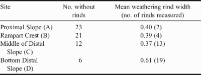
Weathering rind thickness and moss cover were determined at four sites (A to D; Fig. 3) on the southern downslope transect (Y1Y2); the proximal slope, ridge crest, and two sites on the distal slope (i.e. middle and lower distal slope). Weathering indices have been successfully used for relative-age dating of grey lavas on the island (Sumner et al. Reference Sumner, Nel, Holness and Boelhouwers2002); similar methods have been used on blocks elsewhere (e.g. McCarroll Reference McCarroll1989, Boelhouwers et al. Reference Boelhouwers, Jager and De Joode1999). Twenty five measurements of upper-surface weathering rind thickness were made with a calliper (0.05 mm resolution) at each of the sites by breaking clasts in the field. Upper surface moss cover of individual blocks was recorded to indicate where fresh debris was accumulating. Moss coverage was based on visual division of the collected data and the categories chosen were as follows: moss free, 1–9%, 10–24%, 25–49% and > 50% for the nearest 50 blocks to the sites.
Observations and measurements
Snow accumulation was found to be enhanced east of the cliff where there is shade and protection from wind-scouring during storms, particularly in winter. Under the present-day snowfall regime, the trough has little snow infill in summer but in winter it reaches the rampart crest in places (Fig. 4a). Where the rampart crest is farthest from the backwall, the snowbed tends to fill the trough to a step visible at A on transect Y1Y2 (Fig. 5). A large snow bed and hard snow was observed to facilitate supranival clastic debris movement (Fig. 4b). No pyroclastic (ash) material has been incorporated into the rampart. However, fines consisting of wind-blown scoria, which settled on the snowbed and pyroclastic (ash) sediment, and transported by small debris flows from the ash layer on the backwall, were noted on the snow surface. In the absence of a snowbed in the late summer of 2003, small debris flows, similar to those found elsewhere on the island (Boelhouwers et al. Reference Boelhouwers, Holness and Sumner2000), carried pyroclastic (ash) material into the trough on the lower backwall. Fresh clasts or larger blocks were notably absent in the trough above the proximal slope in the vicinity of the debris flows suggesting that snow-free conditions are infrequent.

Fig. 4. a. Snow infill of the proximal trough nearly reaching the rampart crest; note the debris lying on the snowbed, and b. evidence of supranival debris movement (Holness; December Reference Holness and Boelhouwers1998).

Fig. 5. Plan view of the pronival rampart and surrounding area.
Figures 3 & 5 illustrate crest, backwall, lateral and longitudinal extent of the rampart, representative facet angles, and the position of the longitudinal transects. Maximum rampart thickness, from the base of the proximal trough to the crest (Fig. 3) is 8 m and coincides with the maximum height of the upper layer of grey lava, which in this case represents the source material in the backwall (Fig. 2a). The distance of the rampart crest from the backwall also corresponds with the availability of source material in the backwall (Figs 2a & 5). The north–south thinning of the upper layer of grey lava results in a decline in source material in the same direction, which, in turn, has resulted in the southern section of the rampart crest being situated farther away from the backwall. A discontinuous step running along the proximal slope, particularly evident on Transect Y, is found where the rampart is farthest from the backwall (A, transect Y1Y2, Fig. 3). Facet angles measured adjacent to the crest give an average angle of 34° for the proximal slope, similar to that of adjacent scree slopes at their repose angles, and an average representative facet angle of the rectilinear distal slope of 22° (Table I, Fig. 5). At no point on the distal slope is material at angle of repose of the scree adjacent to the rampart. The width of the rampart was 79 m (Transect Y, Table I) and maximum crest-talus distance was 47 m.
Table I. Rampart morphological dimensions (L = 140 m) derived from measurements noted in Fig. 3.

Few clasts in the vicinity of the rampart crest (B, Table II) and extending into the trough (A, Table II) had surface weathering rinds. Where clasts had weathering rinds at these two locations, the measured mean rind thicknesses were 0.39 mm and 0.40 mm respectively; probably reflecting pre-depositional, as opposed to in situ weathering. The number of clasts showing rinds increased down the distal slope and this is considered a function of both pre-weathering and in situ weathering. A mean value of 0.37 mm was found midway down the distal slope, which is similar to that found for the clasts with rinds higher upslope. On the lower distal slope, fewer rind-free clasts were found, and the mean value for rinds measured was notably higher at 0.67 mm and is suggested to be a result of longer exposure.
Table II. Weathering rind thickness (mm) measured for the proximal slope (A), rampart crest (B), middle of distal slope (C) and lower distal slope (D) positions noted in Fig. 3. Sample size is 25.
The extent of moss cover decreased noticeably in the vicinity of the ridge. An additional sampling point (B2, Fig. 6) was used 5 m down the distal slope and site B1 in Fig. 6, therefore, corresponds with site B in Table II. On the proximal slope, most clasts are moss free or less than 10% covered (Fig. 6). Moss cover increases at the ridge crest (B1) and down the proximal slope to the lower distal slope where most clasts are more than 50% covered (Fig. 6). The above data illustrate frequent deposition in the upper region of the rampart, specifically the crest and proximal slope, similar to the findings of Sancho et al. (Reference Sancho, Palacios, De Marcos and Valladares2001) for lichen on a pronival rampart in Spain.

Fig. 6. Mean moss cover (n = 50 per site ) at the sample sites; point B1 corresponds to the ridge crest and B2 is located 5 m down the distal slope.
Rampart origin and growth
Any landform regarded as periglacial, including pronival ramparts, may be periglacial only in origin, growth, or maintenance, or it may be periglacial throughout its development (Thorn Reference Thorn, Dixon and Abrahams1992). Consequently, various modes of rampart evolution have been suggested (Curry et al. Reference Curry, Walden and Cheshire2001). Justification for regarding the Marion Island feature as a pronival rampart, according to diagnostic criteria (Shakesby Reference Shakesby1997), are presented in Table III and the following discussion serves to identify its origin and formative processes. The landform on Marion Island is clearly not a moraine due to the limited distance of the rampart crest to the backwall, and climatic conditions on the island exclude an origin through the deformation of ice-rich permafrost (rock glacier creep). A landslide origin is also negated, even though the backwall appears to be aligned on an island-scale lineament or fault, since no pyroclastic (ash) material from the middle section of backwall is incorporated within the landform. The distinctly sinuous crest of the Marion Island landform is not typical of a landslide and supports a pronival origin and development. Supranival transport of material was frequently observed and the rampart appears not to conform to diagnostic criteria for other landforms. Moreover, rampart thickness and the rampart crest distance from backwall show a relationship to backwall source material; explained through upslope growth of the pronival rampart.
Table III. Diagnostic criteria for distinguishing a rampart from other talus landforms (adapted from Shakesby Reference Shakesby1997).

The rampart has formed in a location that favours snow accumulation, while on either side of the rampart, at sites that do not favour snow accumulation, scree slopes have developed. In addition, rampart crest length and cross-profile asymmetry are consistent with suggested ‘diagnostic’ criteria reviewed by Shakesby (Reference Shakesby1997) (Table III). However, this rampart exhibits shallower distal (19–26°) than proximal slope angles (31–39°) in contrast to the characteristics suggested by Ballantyne & Kirkbride (Reference Ballantyne and Kirkbride1986). The original underlying slope angle and basal slope region may play a greater role in determining where debris accumulates on the rampart than has previously been addressed. A shallow original underlying slope angle would tend to only support a shallow snowbed slope angle inhibiting clasts from reaching the rampart crest and being deposited on the distal slope. Debris accumulation would not necessarily occur on the distal slope of the rampart thus preventing the distal slope from developing at repose. It is proposed that the original underlying slope can control whether the distal slope or proximal slope will become the ‘repose slope’ of the rampart, particularly when coupled with a variable snowbed size.
Moss cover and weathering rind data indicate that material is ‘younger’ on the upper, and ‘older’ on the lower part of the rampart. Thus, the accumulation of debris on the proximal slope of the pronival rampart at the foot of a non-permanent snowbed combined with the evidence that the distal slope is not at ‘repose’ indicates that this rampart cannot develop following the model of downslope migration proposed by Ballantyne & Kirkbride (Reference Ballantyne and Kirkbride1986). An upslope direction of accumulation is apparent, with the crest of the rampart acting as the zone for material deposition; debris is deposited in the area of the crest or on the proximal slope of the rampart. During seasonal snowbed melt, even if only partial, the crest material falls as scree down the proximal slope. Scattered fresh debris, decreasing in quantity towards its base, occurs over the distal slope and is probably derived from rockfalls. Upslope (retrogressive) growth of the rampart explains the rectilinear morphology of the distal section and the existence of a recently formed step on the proximal slope. The step on the proximal slope is probably due to variability in both the snowbed size, largely as a result of reduced snowfall in the latter half of the twentieth century (see Smith Reference Smith2002, Sumner et al. Reference Sumner, Meiklejohn, Boelhouwers and Hedding2004) and production of debris from the backwall.
The maximum length of the rampart, from the rampart crest to the foot of the distal slope is approximately 65 m. Weathering rind thicknesses on the lower (oldest) part of slope are in accord with the grey lava surface data for immediate post-glacial (Holocene) surfaces found elsewhere on the island (Sumner et al. Reference Sumner, Nel, Holness and Boelhouwers2002). However, the absolute age of the rampart is not known and may, therefore, have been created and destroyed many times during the Holocene. It is also pertinent to highlight that the growth rate would probably have experienced some variation in response to fluctuations in the Holocene climate and debris supply; as indicated by other periglacial landforms on the island (Holness & Boelhouwers Reference Holness and Boelhouwers1998).
The observation of rockfall debris transport and accumulation at the foot of a non-permanent snowbed is extremely significant in the use of pronival ramparts as palaeoclimatic indicators. Shakesby (Reference Shakesby1997) highlights the hazards in using fossil pronival ramparts for palaeoclimatic reconstruction, because the contemporary climatic conditions necessary for rampart formation are not yet fully understood. In addition, the mode of development may not follow a specific model. It is noteworthy that on Marion Island recent warming has caused the disappearance of permanent snow on the island (Sumner et al. Reference Sumner, Meiklejohn, Boelhouwers and Hedding2004), further complicating observations and possibly slowing the rate of debris accretion. Grab (Reference Grab1996) highlights the apparently similarly rapid retreat of the snowline in the late twentieth century at the approximate altitude of a pronival rampart on Mount Kenya, which is used to infer fairly recent pronival rampart development. An upslope (retrogressive) mode of rampart growth could, however, provide an alternative mode of development rather than recent genesis. In Spain, Sancho et al. (Reference Sancho, Palacios, De Marcos and Valladares2001) considered that the Hoya pronival rampart was completely inactive since the snowbed was too small to facilitate rampart growth, but this is only applicable to downslope rampart development. Lichenometric data presented by Sancho et al. (Reference Sancho, Palacios, De Marcos and Valladares2001) for the constituent material of the proximal slope of rampart suggests a possible upslope manner of rampart growth initiated by the decreasing size of the snowbed as a plausible alternative.
Conclusion
Few actively-forming pronival ramparts have been described worldwide and none in detail from the sub-Antarctic. An actively-forming pronival rampart investigated on Marion Island at 900 m a.s.l. consists of clastic material with occasional interstitial fines, is of a wholly pronival rampart origin and has grown by upslope rather than downslope accretion. Relative-age dating, in the form of percentage moss coverage and weathering-rind thickness, and the active accumulation on the rampart crest and proximal slope, where the snowbed has decreased in thickness, support the proposed upslope extension mode. A reduction in snowbed height on the proximal slope of the rampart is, therefore, seen as a key component of the proposed retrogressive mode of development. Since the most recent glaciation ended at approximately 13 000 bp, debris accumulation has probably fluctuated throughout the Holocene in response to changing climate and debris supply. A step on part of the proximal slope is interpreted as a function of recent declining snowfalls on island.
The proposed mode of development contrasts with those suggested for pronival ramparts elsewhere, where accumulation and extension occur in a downslope direction. A lower underlying basal slope gradient combined with a seasonally fluctuating, possibly generally declining, snowbed volume are proposed as the controlling factors in rampart growth direction. Active formation of a pronival rampart at the foot of a non-permanent snowbed also highlights the importance for a clear understanding of the climatic thresholds governing rampart origin and development. This study illustrates the potential, highlighted by Boelhouwers & Hall (Reference Boelhouwers and Hall2002) that a hyper-maritime (sub-Antarctic) perspective may have in improving the understanding of the basic driving mechanisms and boundary conditions in permafrost and periglacial processes. Observation of a seemingly similar manner of debris accumulation of a pronival rampart on Mount Kenya (Grab Reference Grab1996) and reinterpretation of lichenometric data for a pronival rampart in the hollow of the Gredos Cirque in Spain (Sancho et al. Reference Sancho, Palacios, De Marcos and Valladares2001), of which both are associated with disappearing snowlines in their vicinity, suggest that these landforms may provide other examples of a landscape process-response to climate change, manifested in the an upslope (retrogressive) mode of rampart development.
Acknowledgements
The South African National Antarctic Programme under the auspices of the Departments of Environmental Affairs and Tourism, and Science and Technology, provided logistical and financial support. The authors are grateful to Jan Boelhouwers, Werner Nel, Jay le Roux, Anni Schwirzer, Barend van der Merwe and Natalie Callaghan for their assistance and comments in the field.


