


Introduction
The shape of a territory is a long-term evolution in which many factors affected its morphology and evolution. Sometimes there are strong economic reasons that can explain the creation of new infrastructures or even the foundation of new urban settlements. In other cases, the design of a transport network seems to respond to other strategic insights, such as political or social requirements. The analysis of transport networks could help to understand the logic behind political decisions and their impact on the structure of territories and their economies.
In this article, the evolution of the transport networks from a wide territory has been analyzed to recognize the role of the politics and their economic influence in the design and territorial organization. A more detailed study about one particular region within this territory has been included to visualize more details about the impact of the changes in the infrastructures in a territory. First, the analysis of the evolution transport networks of the Iberian Peninsula is presented to visualize the continuities and variations in a wide geographical and temporary frame with a complex political and historical evolution. This evolution of a wide territory has been used to recognize the role of the political organization and their economic influence in the territorial design. After this, a second study is included to present a focused analysis of the creation and maintenance of a brand-new road network in the mountainous region of the Pyrenees during Roman times and its impact on the future configuration of this area.
Methodologically, this article is based on the use of networks science analyses that have been applied to the historical intermodal transport systems. The Mercator-e projectFootnote 1 has been based on the use of historical GIS methodologies (Gregory and Haley Reference Gregory and Richard2007) to record, store, and disseminate historical data about roads and routes in the Iberian Peninsula. This first approach creating a geographic database, allowed us to work and develop further analysis using a highly detailed road network. The main purpose of this article is to understand the patterns of relationships between cities, territories, and roads in each period and how those patterns are related to the political situation. Network science analyses have been identified as one of the most adequate tools to analyze this kind of patterns (Brughmans Reference Brughmans2010; Graham Reference Graham2006; Knappett et al. Reference Knappett2008). These analyses allow us to visualize and understand the connectivity of the territories of each studied period and compare the evolution, the changes, and the continuities of the transport network.
The Transport Networks of the Iberian Peninsula
The basis of this project is firstly based on a thorough, detailed, and systematic study of the transport networks that were built in the Iberian Peninsula during four different historical periods: Roman times (c.a. second century AD), Middle Ages (c.a. twelfth century), Early Modern Times (c.a. seventeenth century), and the mid-nineteenth century.
The studies of the historical road systems in this geographical scope have a very long tradition. Since the nineteenth century (and even before) some scholars recorded and studied some Roman roads using written Roman sources like “itineraria.”Footnote 2 Some years later, the studies on historical transportation in the Iberian Peninsula focused on the identification of the road infrastructures also based on ancient literary and archaeological sources (Chevallier Reference Chevallier1997; Roldán Reference Roldán1975; Silliéres Reference Silliéres1990; Solana and Hernández Reference Solana and Liborio2002; Solana and Sagredo Reference Solana and Luis1998). Due to the wide extension of the Iberian Peninsula, regional studies have been published since the mid-nineteenth century until recent times.Footnote 3 A better knowledge of the engineering works (Moreno Reference Moreno2006) allowed us to distinguish between roads built in diverse periods according to material and engineering features as well as logic layouts according to ancient conditions. However, the development of GIS became a breakthrough for transportation studies because some early hypotheses could be modeled in more scientific ways. The application of least cost path (LCP) combining maps of variables (e.g., surface, relief, hydrology) provided more accurate proposals for road layouts (Fiz and Orengo Reference Fiz and Hèctor2008; Güimil and Parcero Reference Güimil and César2015). In recent years, there has been a growing interest in the study of the Roman road system in the Iberian Peninsula.Footnote 4 Besides, the network analysis applications in GIS allows modeling the time and cost involved in traveling from one destination to another combining different means of transport (Carreras and de Soto Reference de Soto2010). The roads of the Iberian Peninsula during the medieval times have been very poorly studied until now. Maybe one exception is a very detailed and comprehensive study developed and published about the Northeastern Iberian Peninsula.Footnote 5 General studies about medieval road networks, travels, and product mobility have been published since the mid-twentieth century (Alsina Reference Alsina1954; Carreras Candi 1993; Córdoba 2001; García de Cortazar Reference García and José1996; Uriol Reference Uriol1990). But maybe the Arabic medieval geographers have offered the most detailed information about routes and roads of the Iberian Peninsula (Castillo Reference Castillo2001; Roda Reference Roda and Manuel Criado1996). Recently, medieval researchers are also incorporating GIS techniques to analyze and digitize road paths offering new and detailed information (Negre Reference Negre2013). The transport systems of the Iberian Peninsula during the Early Modern period have been the object of several studies (Almaric Reference Almaric2001; Casado Alonso Reference Casado Alonso1984, 1997; Córdoba Reference Córdoba1997; Diago and Laredo Reference Diago and Miguel Ángel2009; Ringrose 1987; Uriol Reference Uriol1990). Most of these studies have been focused on the economic impact of the transport routes and used information extracted from travel books and post roads compilations (Reference DeDe Villuga 1951; Escribano Reference Escribano1775; Swineburne Reference Swineburne1779). For the last period analyzed in this article, the mid-nineteenth century, several authors analyzed the problems of the transport systems in relationship with the economic crisis of the Spanish kingdom (between 1750–1850) (Madrazo Reference Madrazo1984, 2001; Reguera Rodriguez Reference Reguera Rodríguez1996; Ringrose Reference Ringrose1972; Uriol Reference Uriol1993). There are also some travel sources written and published by local and international travelers (Alarcón Reference Alarcón1922; Langlois Reference Langlois1835; Serrano Reference Serrano1993).
Thanks to the work developed within the framework of the Mercator-e project (de Soto Reference de Soto2019), it has been possible to use the transport networks of these four historical periods that are more complete and more detailed than those created to this day. For the study of Roman-era roads (figure 1), it has been necessary to compile many archaeological and historical studies published to this day. The digitisation of each of the Roman roads has considered all the available information such as the main ancient written sources like the Antonine Itinerary, the Tabula Peutingeriana or the Vicarello Beakers. Those Itineraria are ancient compilations of routes like the Antonine Itinerary or the Vicarello Beakers are formed by lists of stopping places and the distances between them covering all the Empire and had been studied since the end of the nineteenth century (Kubitschek Reference Kubitschek1916; Miller Reference Miller1916). The Peutinger Table is a medieval copy of an ancient map with schematic routes depicted representing all the Roman Empire geography (Bosio Reference Bosio1983; Cuntz Reference Cuntz1894). The information from those kinds of sources related to the Iberian Peninsula has been deeply analysed analyzed by Roldán (Reference Roldán1975) or Blázquez (Reference Blázquez2006) among others. But to reconstruct the Roman roads in the Iberian Peninsula, we also have the data offered by other sources like the milestones (Lostal Pros Reference Lostal Pros1992; Solana and Sagredo 2006), or archaeological data published in numerous articles (Arasa Reference Arasa2018; Magallón Reference Magallón1987; Moreno Reference Moreno2007 Silliéres Reference Silliéres1990 among others). It is also important to highlight the many contributions of other researchers who have altruistically offered their data to be incorporated into the project database.Footnote 6 From these data, along with the use of archaeological databases on the Iberian Peninsula, and cartographic data it has been possible to digitize the network of Roman roadways of Hispania. Altogether, 1,278 road segments have been digitized, representing almost 42,000 kilometers of Roman roads. This has been the most detailed and complete map of Roman roads generated to this day. For the medieval era and Early Modern times (figure 1), the data on the communication routes in the Iberian Peninsula is not as complete as we have for the Roman period and the nineteenth century.
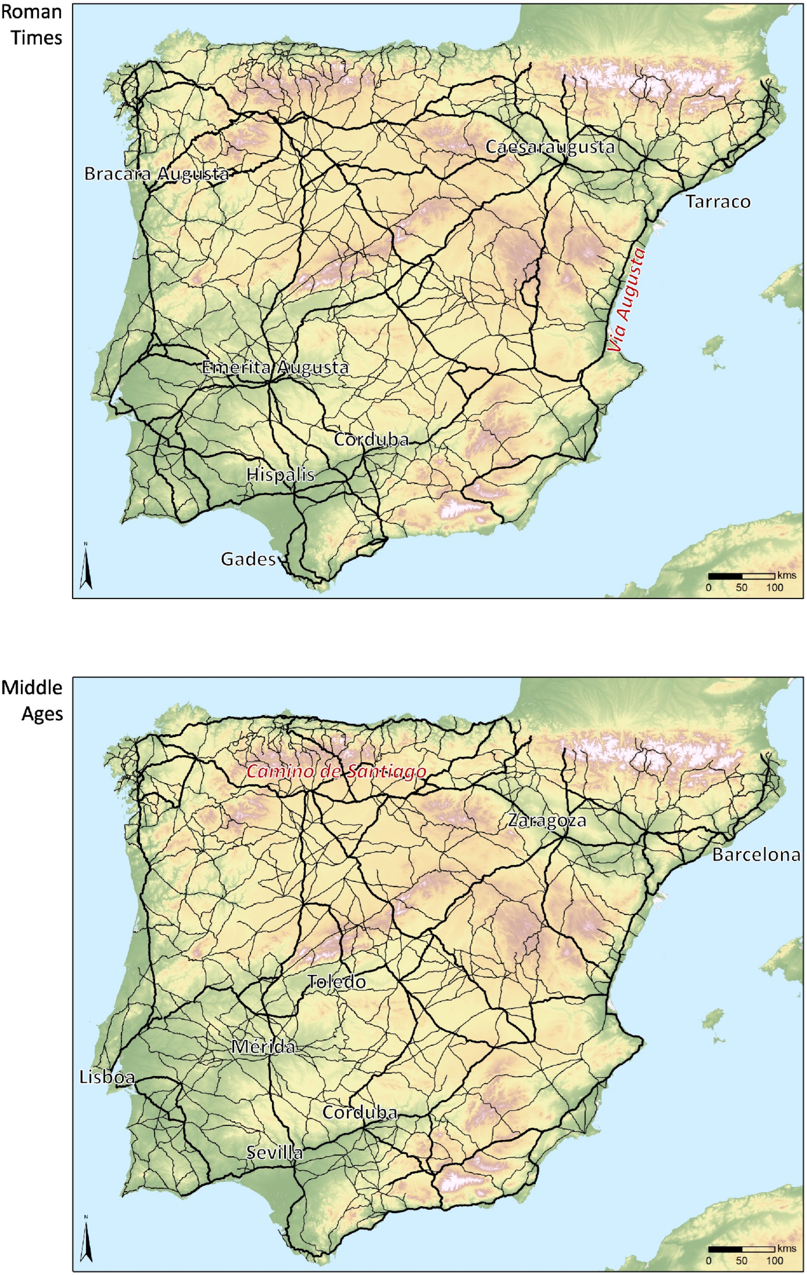
Figure 1. Map of the main and secondary roads of the Iberian Peninsula in Roman and Medieval times.
Notes: Roman times (upper) and medieval era (bottom)
In the case of medieval times, this project has focused on the political situation between the twelfth and thirteenth centuries, a chronological moment that moves away from the Early Middle Ages and therefore the strong influence of Roman communications. To reconstruct the road maps of this period, it has been necessary to collect data from different sources, but above all, from medieval works in which information about routes and trips was collected. Thus, the works of Arab geographers, such as the “Geography” of Al-Idrisi, perhaps one of the most valuable documents, have been compiled (Roda Reference Roda and Manuel Criado1996). Around the year 1154, Al-Idrisi produced a large world map (Tabula Rogeriana) by order of the Sicilian king Roger II along with his work “Geography.” In these documents are provided climatological, geographical, or cultural descriptions, as well as distances in days between cities around the known world. The Calixtino Codex (Liber Sancti Jacobi), written by the French monk Aymeric Picaud toward the year 1139, is also very important, and it consists of one of his five books of a guide of the Camino de Santiago, with the description of its main routes. Within the Iberian Peninsula, it describes especially the Aragonese route through Somport and the Navarre route through Roncesvalles, new and unused itineraries to cross the Pyrenees during the Roman era. The data offered by medieval geographers of past centuries have also been important as they offer information on routes similar to what Al Istakhri and Ibn Hawqal wrote in the tenth century in the “Books of the Roads and Kingdoms” in which they reproduced the geographical elements and communication routes of the known world (García Sanjuán 2016). In the case of the Iberian Peninsula, they reproduce the main existing routes in the territories of Al-Andalus, as well as those that communicated with the main urban centers of the Christian territories. The eleventh century also provided important data on land transport communications thanks to Al-Udri, of which only some important fragments remain, and especially Al-Bakri, with his book of roads and kingdoms. During the digitization process, we had the collaboration of other researchers who shared their data.Footnote 7 Finally, we also used other kinds of information to complete our networks, mostly focused on defining the significance of some roads (Alsina Reference Alsina1954; Balestracci Reference Balestracci2001; Remie Reference Remie1994). In total, 1,329 road segments have been digitized, representing almost 43,000 kilometers of roads.
In the case of the roads of the Modern era (figure 2), we attempted to reconstruct the communication networks from the information obtained from the sixteenth century to the eighteenth century as the documentation on transport networks of the seventeenth century is scarce. To complete this study, we have mainly started with the invaluable information that two sixteenth-century compilations of roads offer us. Firstly, there is the Repertorio de todos los caminos de España: hasta agora nunca visto en el qual allará cualquier viaje que quieran andar muy provechoso para todos los caminantes compuesto por Pedro Juan Villuga valenciano e impresso en Medina del Campo (de Villuga 1951). Published in 1546, this document offers the first compilation of the main transport routes in the Iberian Peninsula during the sixteenth century. Secondly, there is the Repertorio de caminos. Ordenado por Alonso de Meneses, correo. Añadido el Camino de Madrid a Roma. Con un Memorial de muchas cosas sucedidas en España. Y con el Reportorio de cuentas, conforme ala nueva prematica written by Alonso Meneses in 1576, similar to de Villuga’s repertoire but ordered alphabetically from the cities originating each itinerary. We have also used the information related to the multiple trips made by the Spanish and Portuguese monarchs where they usually traveled into their respective countries from the most important roads, the “caminos reales” and other information about the transport networks (Uriol Reference Uriol1990), trade information, and very interesting information compiled by travelers from the sixteenth to eighteenth centuries (Almaric Reference Almaric2001; García Mercadal Reference García1952). The information provided and the use of more contemporary data has allowed us to rebuild a network with 3,653 segments and a total length of almost 73,000 kilometers (including those that existed at the beginning of the nineteenth century as tertiary roads).

Figure 2. Map of the main and secondary roads of the Iberian Peninsula in Modern era and the nineteenth-century.
Notes: Modern era (upper) and nineteenth-century (bottom)
Finally, in the case of the transport network of the nineteenth century (figure 2), the situation of infrastructures during the first years of the mid-nineteenth century was considered. It is at this moment that the first railway network in the Iberian Peninsula is built and, therefore, the territorial organization and peninsular communications were transformed. To recompose this data, it has been necessary to recover an important volume of composite maps between the years 1840 and 1860. Thinking about the possibility of homogenizing all the information, the same source of information has always been used to recompose the communication routes. The used sources have been chosen between the set of maps produced by A. H. Dufour divided by the different provinces of Spain. In the case of Portugal, it has not been possible to get the data from the same source and we have opted for the maps produced by F. Folque. To complete all the transport network data we also took into account other historiographic sources (Madrazo Reference Madrazo1984; Uriol Reference Uriol1993). In these maps, it has been possible to reconstruct both the network of main roads and the secondary and even the tertiary network. The digitalization of all this set of more than 20 maps allowed the creating of a network with 3,370 segments and a length of almost 70,000 kilometers.
The Configuration of the Transport Network
To analyze how the different historical transport networks were configured, in this article we will identify which areas and cities were most well connected and, on the contrary, which territories were isolated. In this article, “connectivity” refers to the capacity for cities and areas to be connected, through different means of transport allowing the mobility of people and commodities. The public expenses devoted to the construction and maintenance of transport infrastructures represented a very huge economic effort for the governments in each historical period. For these reasons, all the well-connected cities should offer solid political, economic, or social justifications to those investments. The evolution of the network structures and its connectivity shows different patterns of political design, favoring some regions and hindering others. The differences between each period will serve us to explain some of each period’s government rulers.
To obtain these calculations, we have analyzed the centrality degree of each city and urban settlement of the Iberian Peninsula. The theoretical basis for the calculation of centrality in this project has been based on the graph theory and the use of network analysis (Dicks Reference Dicks1972; Freeman Reference Freeman1979; Hagget and Chorley Reference Hagget and Richard1969). This theory has already been widely applied in many areas and also in archaeology (Knappett Reference Knappett2013; Mills Reference Mills2017). Taking into account this theory, every element of our reality can be converted into a relationship of nodes (points) and edges (lines) that are connected to each other. Thus, each element is represented by a node and the relationship between them by an edge. If there is a relationship between two nodes, then there is an edge. Otherwise, obviously not. From this set of relationships, a matrix can be created. From this premise, this methodology can be perfectly applied to the case of roads and cities in different historical periods. Each city and crossing represent a node and each route (whether terrestrial, fluvial, or maritime) is represented by an edge.
Initially, as in many other investigations on network analysis, the network created was understood as a binary system by nature, that is, evaluating connections between nodes with a value of 1 if a connection existed and 0 if no connection existed (Isaksen Reference Isaksen2008; Keay and Earl Reference Keay, Graeme, Patrick Le and Pierre2006). Unfortunately, this application of binary networks doesn’t reflect the complexity of a transport network and the different impact (or benefits) of each mean of transport could offer to each city. As not all the means of transport were equally important for the political, economic, and social development of a territory (or a city), not all the transport systems should have the same importance in the calculations of connectivity. For this reason, a weighted network analysis system (Barrat et al. Reference Barrat, Barthelemy, Pastor-Satorras and Vespignani2004) was created in this project. According to this system, the edges of a network are evaluated not only if they are absent or not (binary calculation) but also if they have different values and, therefore, the weight of a node is calculated from the sum of the different values of the edges that are communicated. For nonsocial networks, the weight often represents the capacities of the ties, for example, the airports’ connections (e.g., the number of seats among airports; Colizza et al. Reference Colizza, Romualdo and Alessandro2007; Opsahl et al. Reference Opsahl, Vitoria, Pietro and José2008).
Applying a value to each of the edges depending on the means of transport they represent has been a very discussed and tested element in the development of this project and in previous projects (Carreras and de Soto Reference de Soto2010, de Soto Reference de Soto2010; de Soto and Carreras Reference Carreras2015). The established weighted edges represent the different impacts (in terms of economy and urban development) of each mean of transport. From the historical data obtained from the study of the different transport systems (Carreras and de Soto Reference de Soto2010) it has been established in each historical period that the maritime system was the most economic and fastest mean of transport and offers the greatest transport capacity, until the arrival of the railway. Second, river transport, especially downstream, offered fast and very economical navigation, although not upstream navigation, which was very expensive and slow. Finally, land transport has been divided into the main roads and secondary roads (in this project we also have distinguished tertiary roads for Early Modern and nineteenth-century networks). To determine the weight of each one of the edges, several tests were carried out with different values to observe which values offered more credible and understandable results. This analysis is not intended to evaluate transportation costs as it will be in the following analysis, instead it pretends to analyze the connectivity of each city. Although, at first, it seemed interesting to use weighted values directly depending on transport costs, it could be observed that the results were too exaggerated because the difference in costs (sea 1, river 5/10, land 50Footnote 8 ) was too high (in the same way than other intermediate values). For this reason, it was decided to test various qualitative values until it was determined that the optimal ratio resulted from the choice of minimum values between 4 and 1 (sea 4, river 3, main road 2, secondary road 1) to develop the calculations. Previously to this project, we’ve tested the application of this methodology, in less detailed networks in the Iberian Peninsula and in other Roman territories with interesting results (Carreras and de Soto 2013).
In this project, we have sought the calculation that best helps to visualize and understand the efforts of the different governments to increase the communicability of their diverse territories and the reduction of connectivity of other territories due to the lack of investment in their infrastructures. To do this, we have chosen the calculation of centrality based on obtaining the value k of each node of the network that represents the sum of all communication channels available to a city, settlement, or crossing. As we understand that not all edges had the same value depending on the transport system they represent, we created a weighted network, a study that was assimilated and deepened by several authors (Newman Reference Newman2004). The study of the degree of centrality understood as the value of the sum of connections available to a central node is simple and has the advantage of not needing to know the entire structure of the network (Opsahl et al. Reference Opsahl, Filip and John2010). In our project, this calculation is even more valuable because we know the entire network and the precedent and subsequent centrality situations that allow us to create historical comparisons.
In a weighted network, connectivity data can be represented mathematically by an adjacency matrix where the values are not only zero or one, but are equal instead to the weights on the edges:
 $${{\rm{A}}_{ij}} = {\rm{weight}}\,{\rm{of}}\,{\rm{connection}}\,{\rm{from}}\ {{\rm{}}_i}\,{\rm{t}}{{\rm{o}}\ _j}.{\rm{}}$$
To calculate the degree k of a node in a weighted graph, the procedure is similar to a normal unweighted graph. The degree k of a vertex i in a weighted network is the sum of the weights of the edges attached to it:
 $${k_i} = \sum\limits_j^{} {{A^{ij}}} $$
For example, the Roman Provincial capital of Tarraco (Tarragona) was connected through a seaport, 3 main roads, and 1 secondary road. With a binary network, we could say that this city had a k connectivity equal to 5 (1 seaport + 3 main roads + 1 secondary road = 5 connections). Using weighted networks where each mean of transport has different values, its k connectivity is equal to 11 (1 seaport = 1*4 + 3 main roads = 3*2 (6) + 1 secondary road = 4 + 6 + 1 = 11). On the other side, an inland secondary city like Osca (Huesca) was connected to 2 main roads and 4 secondary roads. If only the number of connections was considered, Osca (2 main roads + 4 secondary roads = 6) should have more connectivity than a bigger and more political city as Tarraco (5). But, if we use weighted networks, the Provincial capital of Tarraco had more connectivity (11) than Osca (2*2 + 4*1 = 4 + 4 = 8).
Once we have a detailed transportation networks of the Iberian Peninsula for each period, it has been easy to transform them into a weighted network to work with (figure 3). As it has been explained in the following text, each edge representing different means of transport has a different weight.
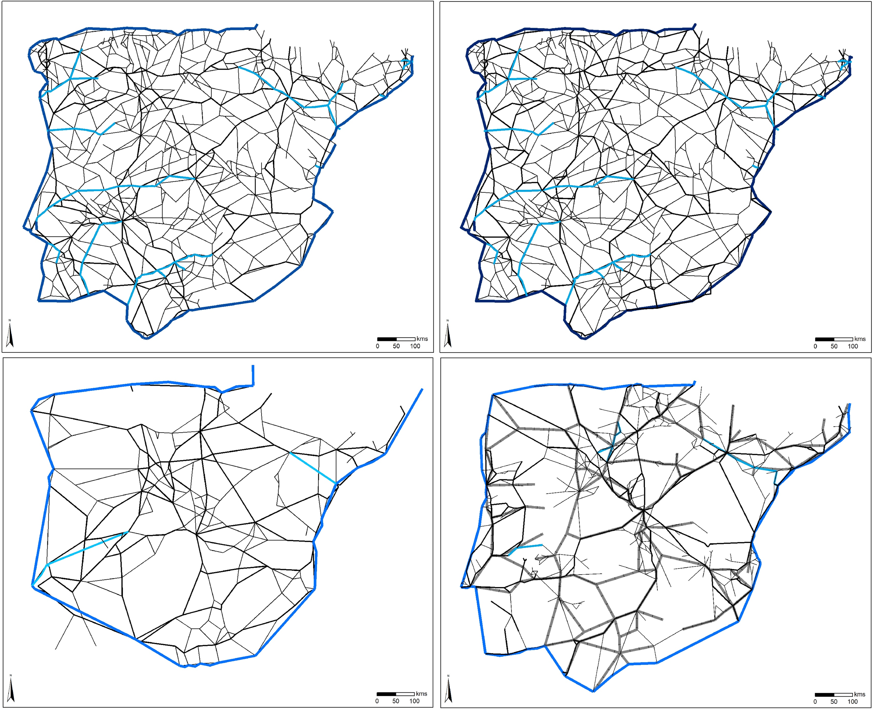
Figure 3. Maps with the weighted networks analyzed in this article.
Notes: Roman times (upper-left), medieval era (upper-right), Early Modern (bottom-left), and mid-nineteenth century (bottom-right). Dark blue: sea connections; light blue: river connections; thick black: main roads; thin black: secondary roads.
Thanks to the calculations made on the connectivity of the different settlements of the Iberian Peninsula in each of the historical periods it is possible to create a map to visualize the results (figures 4-7). From the interpolation of the data obtained in the calculation of the degree k for each one of the different urban settlements and crossings of the transport network, a series of heat maps can be created on the connectivity of the different territories. Thus, the most well-connected (blue color) and the most isolated areas (red color) can be observed.
As can be seen from the observation of the obtained map, during the Roman period the peripheral areas of the peninsula and the river valleys were well connected (figure 4). From the territorial reorganization that Rome undertook in the Iberian Peninsula, the road policies were designed to allow the communication of all the territories of the peninsula. In any case, the best communication of the coastal areas and the river valleys was because to an interest of Rome in prioritizing communications across the coast and the great waterways, especially the Guadalquivir, Ebro, Tajo and Duero Rivers because they made easy the communication with the sea and therefore with the capital of the empire, Rome (Molina Vidal Reference Molina Vidal1995). To complete the access to all the Iberian territories, Rome also created a dense road network in a long construction process various routes that crossed the peninsula (Solana and Sagredo 2006). This fact favored the appearance of diverse crossings of roads with relatively high values of connectivity.
In fact, it seems clear how the Roman structure did not break with some previous indigenous routes that have survived thanks to Greek sources (Timaeus De Mirabilibus Auscultationibus, Avienus Ora Maritima) and that describe routes preserved in the Roman transport network (Alfaro Reference Alfaro2001; Blázquez Reference Blázquez2006). A particular case can be found in the design of communications in the north of the peninsula. These territories were the last to be conquered by the Roman armies thanks to the victory in the Cantabrian Wars (29 BC–26 BC). Firstly by military reasons and secondly due to economic motivations allowed the consolidation of an important horizontal road axis that communicated the rich gold mining areas of the northwestern tip of the peninsula with land routes to Rome through the Pyrenees (Argüelles Reference Argüelles2016).

Figure 4. The Roman Iberian Peninsula connectivity.
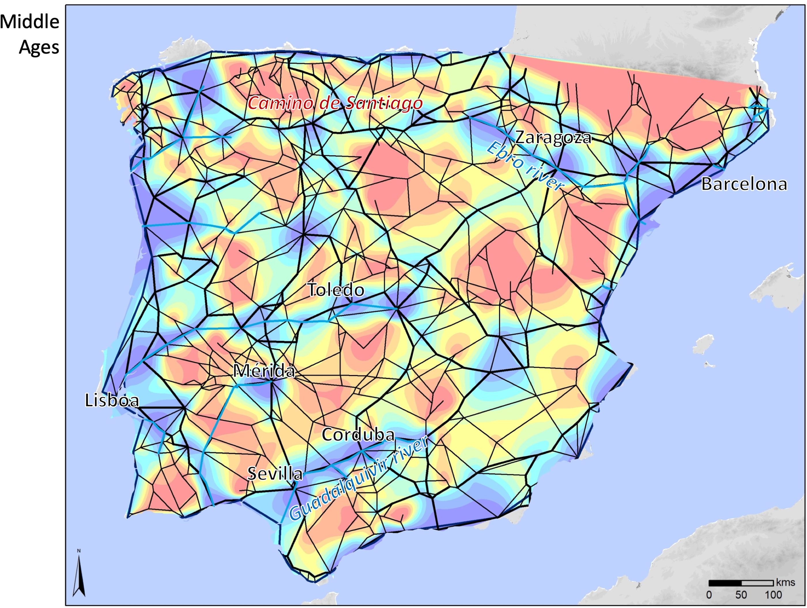
Figure 5. The Iberian Peninsula connectivity in Middle Ages.

Figure 6. The Early Modern Iberian Peninsula connectivity.

Figure 7. The mid-nineteenth-century Iberian Peninsula connectivity.

Figure 8. Connectivity differences of the territories of the Iberian Peninsula. In red, loss of connectivity; in blue, increased connectivity.
Notes: Left: from Roman to medieval times, center: from medieval to modern times, right: from modern times to the nineteenth century.

Figure 9. Main Roman urban foundations in the Central Pyrenees.
Source: Digital Atlas of the Roman Empire: https://dh.gu.se/dare/.

Figure 10. Main Pyrenees roads in Catalonia in early medieval times.
Source: Bolós Reference Bolós1991: 124.
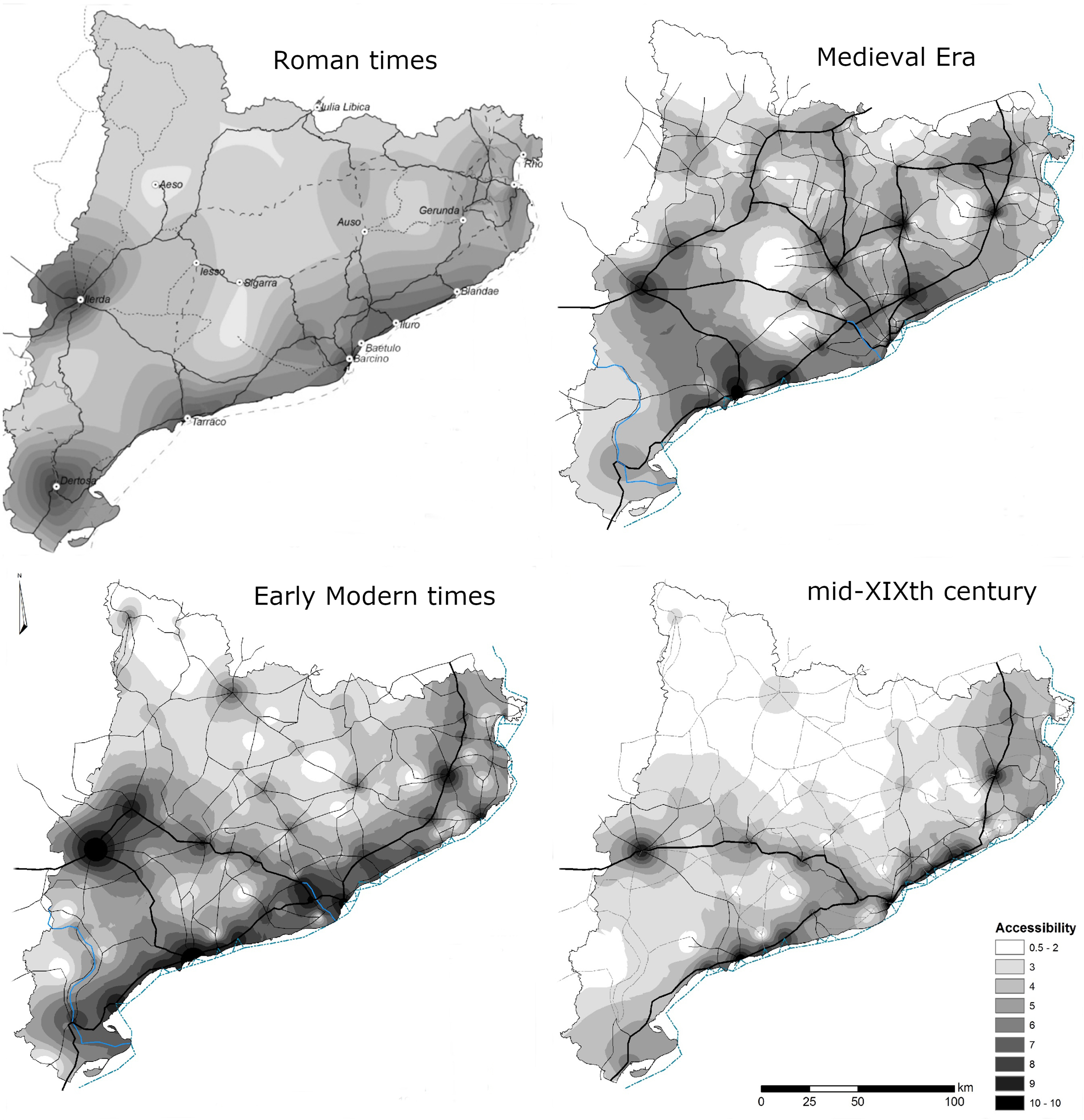
Figure 11. Connectivity maps of the northeastern Iberian Peninsula.
Notes: Roman times (upper-left), medieval era (upper-right), Modern Era (bottom-left), and nineteenth century (bottom-right).
In this way, it can be observed how the great river corridors of the Iberian Peninsula were used intelligently, avoiding the mountainous obstacles of the interior areas. This design adapted to the Iberian geography conditioned the road network structure, creating a great triangle between Tarraco, Asturica Augusta (Astorga), Emerita Augusta, and its extension to Hispalis, from which all the other roads were ordered. In this triangle were included the main administrative centers—provincial governments (legatus) and procurers (procuradores), besides the most outstanding economic centers (Houten Reference Houten2018). From this transport network, the main major cities of the Iberian Peninsula were developed (Carreras Reference Carreras1996).
In medieval times (figure 5), the political situation had varied significantly. Between the eleventh and the thirteenth centuries, there was a political and cultural expansion of the Christian kingdoms across Europe against enemies of other religions. It happened in the Crusades in Holy Land; in the Northern Crusades against pagan Baltic, Finnic, and West Slavic peoples; and in the “Reconquista” of the Iberian Peninsula (Porrinas Reference Porrinas2011). During the twelfth century in the Iberian Peninsula, different kingdoms coexisted and maintained changing relationships between them (Álvarez Borge Reference Álvarez Borge2003; Bartlett Reference Bartlett2003; García de Cortazar Reference García and José1983; Viguera Reference Viguera and Julio1999). On the one hand, in the northern part of the peninsula were several kingdoms that intended to expand to the south as the kingdom of León, Castilla, Navarre, Aragon, and Portugal. On the other hand, the peninsular south was in a convulsive moment because al-Andalus was divided into small Taifa kingdoms that in the first years of the twelfth century were under the Almoravid Empire and later under the Almohads (Viguera Reference Viguera and Julio2007). All this complex political situation shows how many centuries ago there was no political entity in the Iberian Peninsula that managed the entire territory. This situation caused the lack of global design policies that could imply major changes in the transport networks. Instead existed a continuity in the use of the same roads and communication routes created by the Romans among the creation of short new roads to complement the connectivity of the new political hub settlements (Diago and Ladero Reference Diago and Miguel Ángel2009). The roads did not respond to a general plan of terrestrial communications, they obeyed to military, repopulation, pilgrimage, agrarian, commercial, and urban expansion imperatives (Madrazo Reference Madrazo1984). There were, however, some modifications due to changes in the use of communication channels. Routes that in Roman times represented great axes of communication, during the eleventh through thirteenth centuries lost that function, and in the opposite case, Roman routes considered of a secondary character became great axes of communication during the medieval period. A clear example of this situation can be seen, for example, in the appearance and consolidation in medieval times of an axis of capital communication for the Christian society, the Camino de Santiago (Laliena and Duque Reference Laliena and Ángel1994). This axis, which already existed in Roman times, increased the connections of the territories where it was built while the main Roman route that was a few kilometers further south partially lost its importance.
In this period, coastal areas continued to have good connectivity. Each of the peninsular coastal territories was opened internationally through the sea. Thus, the Catalan-Aragonese crown began its expansion toward the Mediterranean through the ports of Barcelona and Tarragona (Ferrer Reference Ferrer, Andrea and Sílvia2009; Santamaria Reference Santamaría1991). The peninsular south coast served as a connection between the territories of al-Andalus and the territories of North Africa (Constable Reference Constable1994). If we look at the map of differences between periods (figure 8), we can observe all these changes more clearly. First, the improvement of connectivity experienced by areas such as the eastern area of al-Andalus in the south where later the kingdom of Granada will be established, the northern Meseta and the area of the medieval kingdom of Portugal, the Cantabrian coast, and, mainly, the consolidated axis of the Camino de Santiago.
The situation in the seventeenth century changed again in a very important way (figure 6). In this period, in the Iberian Peninsula are already settled and differentiated between the two great kingdoms of this territory, Spain and Portugal (Elliot Reference Elliott and Mark1991). Thanks to his rights of succession and a military action, the Spanish monarch Felipe II unified the two kingdoms during some decades, although there was still a clear political, legal, and economic division between them. This was a century of deep crisis in the Iberian Peninsula, mostly in the Spanish kingdom, due mainly to an important population decline, a crisis in the productive system and political decisions harmful to economic development (Ringrose Reference Ringrose1972). This economic situation induced an urban regression from the sixteenth century situation and deep demographic changes (Gelabert Reference Gelabert, Thompson and Bartolomé Yun1994). The setting of the kingdom capital in Madrid and the growing population of this city created the basis to settle the first radial network in the Iberian Peninsula (Alvar Ezquerra Reference Alvar Ezquerra1989; Ringrose Reference Ringrose1973).
As regards the connectivity of the different territories, it can be observed how an incipient radial system began to be glimpsed, which from the peninsular center allows communication with the rest of the territories of the periphery. In the communications, the transport structure fossilized the importance of the Castilian cities during the previous century, especially in the north (e.g., Burgos, Valladolid, Segovia). Those routes heading the north facilitated the transport of European imported commodities to reach Madrid (Diago and Ladero Reference Diago and Miguel Ángel2009). At the same time, the growing importance of coastal territories can be visualized, where the recession was lower, and the beginning of economic improvements began earlier. The infrastructures of the seventeenth century combined the preservation of the previous communicativeness structures in the interior of the peninsula and the connectivty improvements of the peripheric territories along the coast, from the Mediterranean territories to the Portuguese and the Cantabrian coast. In comparison with the previous period studied (figure 8), the areas most favored by the infrastructures created since the sixteenth century are the northern area of Castile and, mainly, the southern territories such as Seville. In this period, we can observe in Spain the substitution of a transport network based on economical conditions for another model focused on political factors like the decision to fix the capital in Madrid (Ringrose Reference Ringrose1973).
Finally, communications in the mid-nineteenth century represent the end of the eighteenth century economic crisis and the beginning of the creation of the contemporary transport system (figure 7) (Madrazo Reference Madrazo1984, 2001; Ringrose Reference Ringrose1972). In Portugal, the connectivity of Lisbon with productive territories of the country increased, like Porto in the north or the Algarve in the south. In the case of Spain, the railway established the radial transport model, where the mainland routes have their origin (or destination) in the capital, Madrid (Mojica and Martí-Henneberg Reference Mojica and Jordi2011). From this neuralgic nucleus, the rest of the territories had good connections depending on their situation regarding the radial axes. In this scheme, the Madrid-Zaragoza-Barcelona, Madrid-Córdoba-Sevilla, and Madrid-Valladolid-León axes stood out for their continuous connectivity. It is interesting to note the continued isolation of the border between the two Iberian countries with long fringes with limited connections. In the map of differences regarding the situation of the seventeenth century (figure 8), the role of the railway in improving the communicativeness of the different peninsular territories stands out significantly (Gómez Mendoza Reference Gómez Mendoza1982, 1989). The appearance of this new transport system affected and redistributed the communications scheme in the new states. In the center of the peninsula, the territories that were far from the new railway infrastructures, declined in connectivity. The economic crisis that they suffered and the lack of investment made their situation within the transport network worse. It is also interesting to observe how the different historical routes that linked territories of the peninsular periphery without going through the center were definitively cut. The horizontal roads such as the Camino de Santiago or the southern stretch of Via Augusta that linked the Mediterranean coast with the west of Andalusia disappeared. The Roman route known as Vía de la Plata, which linked Hispalis (Seville), Emerita Augusta (Mérida), and the north, also disappeared. In the nineteenth-century Spanish road system, all the communications should pass through the capital, Madrid.
The Roman Impact in the Pyrenees: Urbanism and Roads
Taking a general view of transport networks in a very large territory such as the Iberian Peninsula allows us to interpret and visualize large patterns of design and investment in infrastructures. However, this large scale approach does not allow us, at times, to go deep enough into concrete policies that affected complex territories and, in many cases, away from the main urban centers. For this reason, we have proposed this chapter to show the impact of political interests on the development of a mountainous territory.
Romans conquered the Iberian Peninsula during a period of almost centuries, from the IInd Punic War (218–202 BCE) (Apian, Iber. 44; Polibius, III, XXV) until the Cantabrian wars (28-18 BCE) (Florus, II.33). Almost two centuries of continuous conflicts in which Roman armies reduced local populations starting from the Mediterranean coastal strip toward the Atlantic coast. This process implied the creation of minimal land transport infrastructures to supply the fighting Roman armies. Those military corridors were controlled by military fortlets and towers in Republican times to avoid attacks to such supply trains. In the process of conquest, those initial military roads became stable land transport infrastructures, which fulfilled different roles: military, administrative, and commercial.
Augustus was the first Roman emperor who finished the process of conquest in the Iberian Peninsula with the Cantabrian wars (28-18 BC) in the northwest of the Iberian Peninsula. After conquering those mountainous regions in the Picos de Europa, he decided to fix local populations by founding a series of Roman towns such as Asturica Augusta, Braccara Augusta, or Lucus Augustus (Rodà Reference Rodà and Antonio Rodríguez1998). Likewise, he proceeded similarly in other mountainous regions such as the Alps and the Pyrenees. In the Pyrenees, the last indigenous uprising was the Ceretan revolts in the present Cerdanya crashed by Domitius Calvius in 39 BCE (D.C. XLVIII, 7; Vel. Pat. Hist. Roma 2.79.3).
The Pyrenees is an impressive mountains range of 430 kilometers long and more than 50 peaks in the central area higher than 3,000 meters. Apart from the coastal corridors in the Atlantic (Oiasso) and the Mediterranean coast (coll de Perthus), most passes crossed the central part such as:
-
i. Pass of Roncesvalles or Ibañeta (1,057 m)
-
ii. Pass of Somport (1,632 m) between the Aspe and Aragó valleys
-
iii. Pass of Pourtalet (1,794) between the Ossau and Tena valleys
-
iv. Pass of Puymorens (1,921 m) toward the Ariège
-
v. Pass of Perche (1,581 m) toward the Tet valley
Of course, there were other routes used from time to time for military reasons, such the one used by Hannibal’s army to cross the Pyrenees in summer 218 BCE (Muñoz Reference Muñoz2017), that avoid the Mediterranean coastal corridor.
At the end of the first century BCE Augustus created a network of Roman towns connected with a road infrastructure that facilitated easier contact between both sides of the Pyrenees. Some towns such as Iacca (Jaca) along the route to the pass of Somport were built on a previous Iron Age hillfort, but other towns were new foundations (figure 9) (Carreras et al. Reference Carreras, Jordi and Josep2019b).
Lugdunum Convenarum (St. Bertrand de Comminges), located in the territory of the Convenari, seemed to be the first foundation around the mid-first century BCE. This settlement was created as a commercial center due to its strategic situation as a crossing point of different transhumance routes (Esmonde-Cleary Reference Esmonde-Cleary2008). It enjoyed a special location with an excellent river transport along the Garonne and was near the Saint Béat quarries, whose marble was traded in Gaul and Hispania.
Other Gaulish towns were Beharnum (Lescar—ancient Bearn), which as an oppidum of the Vernani connected to Iacca through the Somport’s pass; Tarba (Tarbes), also a former indigenous oppidum and later a Roman town; and Tarusco (Tarascon-sur-Ariège). In the Hispanic side, Iturissa (Burguete) was the main town in the route between Pompaelo (Pamplona) and Aquae Terebellicae (Dax) crossing the Roncesvalles’s pass. This route documents a few well-preserved parts of the Roman road in both sides of the Pyrenees (figure 7). Apart from Iacca (Jaca) already mentioned in the route connected the Somport pass, there were two other towns such as Labitolosa (Puebla de Castro) and Aeso (Isona) in the lowlands, but in the Pyrenees crossing routes.
Finally, there is the case of Iulia Lybica (Llívia) in the middle of the Pyrenees in the route to the Perxa pass toward the Tet valley and the town of Ruscino (Perpignan) (Guardia et al. Reference Guàrdia, Cèsar and Pau2017). Augustus’s policy was a boost with a huge investment in the urban foundations as well as road infrastructures crossing the Pyrenees (Carreras et al. Reference Carreras, Pau and Aina2019a). Although the Roman road technological system is not well known in the Pyrenees because most roads were still used in medieval and modern periods, the contemporaneous infrastructures in the Alps provide us with an interesting comparison. The example of the road toward Saint Bertrand’s pass shows how Romans cut the rock, created artificial terraces, and built channels to divert waters, drainages, and even tunnels. Those works in the Alps started in the Augustus reign but later resumed by the emperor Claudius (Mollo Mezzena, Reference Mollo Mezzena, Stefanella and Lorenzo1992).
The roads were completed with a network of hostels (mansiones) every 25–30 miles where people could rest and eat, and stables (mutationes) where people could change animals (around 15 miles). Little is known about those buildings in the Pyrenees area, but there are inscriptions and constructions along the Roman roads that may have fulfilled these functions.
The whole administration of the Pyrenees was completed by creating a series of customs (stationes) between the Roman provinces of Gaul and Hispania Citerior where traders should pay a toll of 2 or 2.5 percent value of the transported merchandises (portoria—quadragessima or quiquagessima). There is an inscription indicating that Lugdunum Convenarum had a statio, and probably the same happened with Iulia Lybica (Carreras et al. Reference Carreras, Jordi and Josep2019b).
This network of cities and communication routes established by Rome was maintained for at least 2 centuries and allowed circulation through the Pyrenees. Despite this constructive activity in the mountainous territories, most of the commercial land traffic used the coastal corridors along the Bay of Biscay and the Mediterranean. At the beginning of the third century AD, some cities were abandoned, and others reduced their size. In the case of Iulia Lybica, there was a documented drop of imports in the town, which suggests limited traffic along the road crossing the Perxa pass (Guardia et al. Reference Guàrdia, Cèsar and Pau2017).
Medieval Continuity: Evolution of the Former Infrastructures
The medieval period was continuity in terms of the development of transport infrastructures. Most Roman roads were still in use and were distinguished by a width of 4.5 meters and good drainage, which was enough for traveling wagons; that is why they were called “carreres” (wagon roads). The “carreres” were public roads under royal protection (camins rals) common in the plains and wide valleys such as the one in Cerdanya traced by the Segre route. These medieval roads were made of pressed earth, so they became muddy in winter and difficult to transit (Riera Reference Riera2002: 445–46).
In the higher mountains or places with steeply gradient, there were animal tracks (“de bast”), which were normally 1.10 meters wide with some wider places for crossing animals in both directions. These were the typical Pyrenees roads, which were normally public but there were also private tracks with toll payment.
Regarding the towns, some old Roman centers such as Iacca (Jaca) or Iluro (Oloron) were occupied again and became the main stops in the route crossing Somport’s pass, perhaps the most successful route in medieval times together with the two coastal corridors. From Oloron, traders could go to Tarbes, Toulouse, and Pau. In the eighteenth to nineteenth century, traders carried wool, species, olive oil, salt, and pack animals toward the North and ovicaprids, textiles, Occitan cake, and English wool toward the South.
On the contrary, the Catalan central routes were not so popular. The Segre route connecting Perpignan to Lleida was still in use, but with an important change. The city of Iulia Lybica (Llívia) lost its importance as a prominent settlement in favor of the new medieval towns of the nearby Puigcerdà (thirteenth-century foundation) and Seu d’Urgell (the capital of Urgell’s bishopry). Puigcerdà was also the end of the Llobregat routes that connected Barcelona with Manresa and Berga or the Besós route following the Osona plain and the river Ter up to Ripoll, and from here to Puigcerdà crossing the Collada de Tosses (figure 10).
Medieval sources reveal that the critical points of those routes were the river crossing. There were only a few free fords to cross the Pyrenees rivers, whereas the rest had bridges and barges for crossing. In both cases, merchants had to pay a toll to the authority, either local noblemen, towns, or monasteries. For instance, the Segre route included pay toll bridges at Vilafranca de Conflent to cross the river Tet, at Puigcerdà to cross the Arabó, and at Pont de Bar, Seu d’Urgell, Tresponts, Organyà, and Balaguer to cross the Segre. Some of the newborn towns were at those crossing river points (Vilafranca de Conflent, Puigcerdà, Seu d’Urgell, Organyà, and Balaguer).
Thanks to the Roman road policy, the medieval era was undoubtedly the time of best communications in the Pyrenees. The political process of the peninsula from the eighth century, and especially from the ninth and tenth centuries with the consolidation of the Marca Hispanica, led to a boom in mountain communications in the area of the Pyrenees. Just from the consolidation of the Carolingian Empire with the coronation of Charlemagne, it was necessary to establish a march, a border, between the Frankish Carolingian Empire and the territories of al-Andalus ruled by the Umayyad Caliphate (Viguera Reference Viguera and Julio2007). This march was formed by the creation of some small lordships and counties beyond the rule of the Frankish imperial rule located in the Iberian Pyrenees. The small political fragmentation of this Pyrenean territories, but under the rule of the Frankish Carolingian Empire (in the early medieval times) until the tenth century when those counties were practically independent from the kingdom of France (Abadal Reference Abadal2007), favored the consolidation of the main roads built by the Romans connecting with septentrional territories and at the same time the construction of some small mountainous routes that allowed the military and commercial connection between those counties. This is reflected in the connectivity of this entire territory (figure 11). Although, obviously the main commercial routes continued to be located in routes closer to the coast, in this historic period important cities in the mountain developed.
From modern times, the Pyrenees begin to lose prominence mainly due to the lack of economic productivity in the mountainous areas and their limited road access. The road system gradually degraded over the centuries in favor of the main coastal routes and the route from Barcelona to the peninsular interior where the capital was located, passing through Lleida and Zaragoza. However, although the southern part of the Pyrenees lost connectivity in relation to the Spanish transport network, it still maintained continuous contact with the French territories (Pojada Reference Pojada2012). Thus, various commercial documents and notarial acts show that there was a trade in modern times that crossed the Pyrenees in both directions. Wool, salt, and oil were transported from the south of the Pyrenees (Codina Reference Codina2005) and the famous Spanish horses were illegally traded. In these routes, some populations condensed the products to transport them in caravans. These populations were Puigcerdà, Andorra, and Vall d’Aran (Blaquière Reference Blaquière1963; Vidal Reference Vidal1984). In the opposite direction, from France an important trade of some animals like the mules (Poujade Reference Poujade2007), products derived from the fish like Cod, sardines, or conger eel or some products manufactured like cloaks was developed (Larguier Reference Larguier2005; Pojada Reference Pojada2012). But there was also a wide variety of products that came to Catalonia mainly from Toulouse such as hats, leather goods, copper, lead, cheese, sugar, tobacco, spices, religious objects, combs, cowbells, stockings, threads and ribbons, various needles, knives, nails, shovels, hooks, and containers that the merchants, often emigrants, went to search for in Toulouse and returned to Catalonia (Pojada Reference Pojada2012).
This tendency of loss of connectivity of the Pyrenees within the Spanish transport network was even more stressed with the reforms carried out by Spain between the eighteenth and nineteenth centuries (Madrazo Reference Madrazo2001; Ringrose Reference Ringrose1972) prior the creation of the railway (figure 9). The radial road system defined from Madrid connects the capital with the main peripheral cities but leaves in the background the rest of the territories, as in this case the Pyrenees. The system is connected to the coastal and inland manufacturing cities, such as Manresa or Terrassa. However, it is difficult to reach populations located in the closest zones to the Pyrenees.
Conclusions
Finding, defining, and quantifying the different motivations behind the configuration of transport networks in each historical period is a complex task. To obtain information that offers correct answers, it is necessary to carry out an in-depth study of each historical period and in each territory, as well as to manage data from previous periods.
In this project, despite having a great deal of information from different areas related to the history of the Iberian Peninsula, it has been tried to focus the research on the development of a methodology that can be used to quantify and compare the data of the configuration of the networks of transport of the same territory in different historical periods.
As we have tried to show in the preceding pages, the calculation of the connectivity of cities and territories in a transport network can show the relationship between political motivations and the design of infrastructures. These motivations could be understood as a combination of different economic, military, or social needs among others, which changed over every period. In this article, it has also been possible to demonstrate how the comparison of the data obtained between different historical periods allowed, for example, to compare the connectivity of territories and analyze the evolution of network designing and the impact of those decisions in the Iberian Peninsula urban organization. In this sense, this work shows how the results generated offer a credible overview related to the historical data we currently have. Thus, in every period, but mostly when big and strong estates existed, the politic capitals usually built infrastructures to favor their connectivity, allowing the growth of movement of people and products. This clearly happens both in Roman times and in the mid-nineteenth century and to a lesser degree in modern times. Although, the data of modern times are conditioned by several factors such as the medieval heritage and the period of economic and social crisis that was experienced in the seventeenth century in the Iberian Peninsula. However, the connectivity values of capitals during the Middle Ages declined due to the political situation. The period analyzed (12th century) was very unstable due to the existence of various kingdoms and numerous warlike confrontations that generated constant border changes, creations and disappearances of states and highlighted the lack of a great state power to order the entire territory.
The possibility of visualizing interpolated data on a map allows a better interpretation of the results obtained and a more complete historical interpretation. In each of the generated maps it has been possible to interpret the changes and continuities in the communication structures and observe the best and worst connected territories of the entire network in each historical period. This allowed interpreting the interests of each government in the construction or maintenance of infrastructures.
The second part of this article aimed to delve into the impact of political interests in the articulation of a territory a priori away from the most interesting areas of the Iberian Peninsula. In this way, we can observe how the Roman policy to pacify and control this territory influenced the territorial organization of later centuries, mainly during the Middle Ages. At the same time, after the dense occupation of the Pyrenees during the Medieval era, long centuries of disinterest in the maintenance of transport networks gradually reduced the mobility and connections of the territory.
To conclude, we hope to have offered new tools for the diachronic interpretation of the political and territorial configuration of the Iberian Peninsula. With the combination of the similar connectivity analysis of two different geographical frames we have tried to show the benefits of both studies. On the one hand, we offer an overview in a broad territory that allows observing the effect of large-scale governmental policies. And on the other, we show the effects of the same policies at the regional level, where large-scale invisible economic and commercial micro-effects can be observed in detail.
Acknowledgments
This project was funded by the European Union’s Horizon 2020 research and innovation program under the Marie Skłodowska-Curie grant agreement No 706260. The authors would like to thanks the anonymous referees for their helpful and detailed suggestions.


