

1. Introduction
When European navigators set sail on transatlantic voyages during the sixteenth century, they invariably carried with them a number of maps and charts. These tools were indispensable for the sea passage itself and for any colonizing that was to follow, and in the past few decades the development and use of cartography by sixteenth-century English explorers has become a matter of debate among scholars. Perhaps no single work has broached this subject more closely than the third installment of The History of Cartography series (2007). Collectively, the contributors give the impression that the so-called European cartographic revolution was lost on sixteenth-century English explorers, who were hesitant to utilize maps, which were a relatively new phenomenon in Northern Europe. Sarah Tyacke’s thorough analysis of English chart production makes it clear that the English made few sea charts prior to 1585, leading her to conclude that “mariners distrusted them, and their reluctance to use charts at all, of any sort, continued until at least the 1580s.” In his chapter on map usage among European explorers, Felipe Fernández-Armesto unequivocally states that they “used few maps and made fewer” until the early seventeenth century.Footnote 1
This essay puts forth an alternative interpretation of early modern mapping by examining the often marginalized and misunderstood expedition of Sir Humphrey Gilbert (1539–83), who embraced cartographic materials for a number of purposes during his endeavor to colonize the territory known as Norumbega, roughly equivalent to modern-day New England.Footnote 2 Between 1580 and 1583, at a time when almost no English charts of the Western Hemisphere existed, Gilbert and his supporters produced at least five distinct printed and manuscript maps of North America, each of which formed an integral component of their colonizing project. First, in order to gain permission to colonize, Gilbert’s circle created a map to prove to Queen Elizabeth I (1533–1603) and her advisors that England held land rights to most of North America. Next, the group made Norumbega visible to both literate and nonliterate audiences by printing two promotional maps to fund the expedition, and they devised an innovative nautical chart to guide their vessels across the North Atlantic. Finally, Gilbert’s experts drew up meticulous plans to use the latest cartographic advances in drafting several more maps at sea and in North America to demonstrate their control of the land and to facilitate return voyages to their colony. Their utilization of maps represents a noteworthy progression in the cartography paradigm and in the history of colonization, as maps became less symbolic and more functional to meet the diverse needs associated with overseas settlement.
In recent years, scholars spanning multiple disciplines have reassessed early modern maps as discourses of knowledge and power, and the present study adds to this expanding dialogue.Footnote 3 Focusing primarily on the maps’ projections, their toponymy, and the motif of empty space, this essay illustrates how Gilbert’s cartographers represented the same geographic region (England to Norumbega) in variant ways to persuade their respective audiences to visualize it from a point of view that suited Gilbert’s objectives. Hermeneutic and semiotic analyses of each map yield a fuller understanding of their intended meaning by viewing the maps as texts and by placing them in their historical contexts. Building upon the foundational principles of Benedict Anderson, Henri Lefebvre, and Michel de Certeau — the last of whom concluded that “the map … colonizes space” — this work also elucidates how Gilbert’s coterie used maps and mapping as signifiers of authority within the colonial milieu.Footnote 4 By carefully charting Norumbega’s topography and biota, Gilbert intended to assert his control there and make his supremacy known to Elizabeth. For the first time in England’s history, North America became an area to be settled rather than bypassed, and cartography played a significant part in this transformation.
More than just an overlooked English voyage, then, Gilbert’s expedition and his map use serve as a case study showing the complexity of and research behind England’s earliest colonizing voyages. Historians often view late Tudor exploration as a period characterized by trial and error, but these excursions are more aptly depicted as well-prepared voyages. By 1583 Gilbert’s expedition was three years in the making, and he recruited mapmakers who were among the most skilled practitioners in Elizabethan England. John Dee (1527–1609), the renowned mathematician and sometimes cartographer; Simão Fernandes (ca. 1538–90), the Portuguese émigré with more sailing experience than any Englishman; and Michael Lok (ca. 1532–1622), the map collector and well-traveled merchant adventurer, all conducted substantial research in creating maps to support the expedition. Richard Hakluyt (ca. 1552–1616), the consummate colonization propagandist in the early stages of his career, printed his first book and its two maps to promote the voyage as well. By consulting the most up-to-date atlases, navigational manuals, and almanacs while composing their maps and their instructions for the voyage, these experts offered Gilbert the best chance of establishing his colony.
As England’s first attempt at colonization beyond Britain, Gilbert and his company had no blueprint to follow, and yet their map use was widespread and inventive, which shows that England’s earliest expansionists perceived the usefulness of maps. Although Elizabethan colonizers in Ireland mapped the island beginning in the late 1560s, Norumbega was a largely unknown region across a vast ocean.Footnote 5 Determining its location prior to the voyage required more research and better resources, but Gilbert’s circle designed maps that fulfilled their navigational and promotional purposes. They assigned cartography a prominent place in their expedition and proved that maps could serve various purposes during both the preparation phase and execution of a colonizing voyage.
2. John Dee’s Manuscript Maps: Envisioning an Anglo North America
Decades ago George Parks proclaimed that two charts made by John Dee marked the advent of modern English cartography, and Robert Baldwin recently echoed this sentiment in calling the maps “state-of-the-art geographical and political statements.”Footnote 6 Gilbert’s biographer David B. Quinn found the charts perplexing, and their purpose and relationship to the 1583 expedition remain ambiguous.Footnote 7 Yet thorough analyses of the maps and of the contexts under which they were created suggest that Dee made them specifically to support Gilbert’s voyage. He devised the first map in late 1580 to decisively prove England’s claim to Norumbega and consequently to gain Elizabeth’s approval for the voyage. Three years later and after extensive research, Dee made a second chart to guide Gilbert’s fleet across the North Atlantic.
Dee’s immense library and his assiduously documented associations with several of sixteenth-century Europe’s most prominent cartographers and geographers qualified him to draw maps.Footnote 8 Intent on applying mathematics to resolve navigational problems, Dee’s “Tables Gubernautikes” for finding latitudes and longitudes comprised the majority of his Brytish Complement of the perfect Art of Navigation, which he wrote for the queen in 1576. He used these tables to create maps and charts, including a figural map depicting an anthropomorphic Britain as Elizabeth with crown and sword.Footnote 9 His expertise also made him an indispensable resource for English explorers: Sebastian Cabot (1481–1577), Richard Chancellor (d. 1556), Hugh Willoughby (d. ca. 1554), Stephen Borough (1525–84), and Martin Frobisher (ca. 1535–94) all consulted Dee prior to their voyages.Footnote 10 In 1580 alone Dee assisted the Muscovy Company explorers Arthur Pet and Charles Jackman by providing them with a circumpolar hydrographical chart, a sketch of the opening of the Northeast Passage, and a set of charts for their voyage in search of the passage.Footnote 11
That year Dee also created the earliest map relating to Gilbert’s expedition (fig. 1). Based upon its date and composition, several scholars have posited that Dee made it to promote English expansion, and an examination of its contents clarifies how he molded it to support Gilbert’s expedition.Footnote 12 Dee drew the vellum map amid Gilbert’s preliminary preparations and titled it “Atlantis (named the West Indies in the ordinary way) to correct a representation as still is made common.” It is doubtlessly the same map that Dee presented to Elizabeth, Secretary of State Sir Francis Walsingham (ca. 1532–90), and William Cecil, Lord Burghley (1520–98), on 3 October 1580.Footnote 13 Gilbert had shown his appreciation to Dee a few weeks earlier by granting him all lands in North America above fifty degrees north latitude, which includes most of Canada and rights to the Northwest Passage.Footnote 14 Dee’s map clearly served as an endorsement for colonization, since the reverse lists a dozen British claims to North America that span from the apocryphal explorations of King Arthur in the sixth century to Frobisher’s second voyage in 1577. The map face displayed Gilbert’s intended destination, and the verso affirmed England’s lawful entitlement to that area. Accordingly, Elizabeth and her primary advisors could easily hand the map to individuals at court, members of Parliament, or Privy Counsellors to advertise the voyage and Gilbert’s right to colonize Norumbega.

Figure 1. John Dee. “Ioannis Dee, Anno 1580,” 1580 (detail). Cotton MS Augustus, I.i.1. Courtesy of the British Library Board.
Dee’s use of primarily Spanish and Portuguese nomenclature indicates the map’s provenance, and he likely consulted Portuguese sea charts while making it.Footnote 15 Dee included various details from Gerardus Mercator’s (1512–94) famous 1569 world map, even copying verbatim the cartographer’s invention of the phantom island Groclant: “the Island Groclant whose inhabitants are Swedes by descent.”Footnote 16 In the North Atlantic he also incorporated features of the spurious 1558 map of the Venetian brothers Nicolò and Antonio Zeno. Dee mapped Frobisher’s Meta Incognita and his other recent findings but only mentioned the explorer’s first two voyages on the reverse so as not to remind the queen of Frobisher’s ignominious failure in 1578, which squandered her £4,000 investment. Instead, Dee condensed parts of his own “famous and Ryche Discoveries” (1577) and “Her Maiesties Title Royall, to many forayn Cuntries” (1578).Footnote 17 Citing the law of nations, civil law, and divine law, he professed England’s claim to all American territory north of Florida. Such details imply that Dee made the map to prove England’s claim to Norumbega and to seek Elizabeth’s support for Gilbert’s expedition. Either that, or he presented it to the queen to encourage her to reinstate Gilbert’s letters patent, which she had revoked after his 1578 expedition resorted to piracy.Footnote 18
The map’s layout corroborates these theories. It encompasses the north half of the Western Hemisphere and has a fairly clear focus. Rather than placing Europe or the Atlantic at the center of his map like other European cartographers, Dee emphasized Gilbert’s “NOROMBEGA” as his map’s focal point. As Rhonda Lemke Sanford and other scholars have made evident, even “the most rudimentary maps privilege the center.”Footnote 19 Cartographers placed salient locations at the middle of their maps, where a reader’s gaze typically gravitated. Just as medieval, Jerusalem-centered maps reflected their makers’ reverence for that city, Dee’s map gave Norumbega precedence over all other locations.
On Dee’s map, the territory of Norumbega stretches from the coast at forty-two degrees north to forty-five degrees, near the confluence of two rivers, which converge as the “Rio de Gamas.” Portuguese explorer Esteban Gómez (ca. 1483–1538) assigned this name to Maine’s Penobscot River on account of the plentiful deer that he viewed on its banks during his search for the Northwest Passage in 1525. Dee mistook the Penobscot for the Providence River, which feeds Narragansett Bay, Gilbert’s projected terminus. Gilbert chose to colonize the Narragansett after speaking with Richard Hakluyt the elder (ca. 1530–91), who suggested that he settle on an island within a bay at the mouth of a navigable river to expedite Anglo–Native American trade.Footnote 20 Gilbert had also read André Thévet’s (1516–90) La cosmographie universelle (1575), in which the French cosmographer depicted the Norumbega River as an ideal location for a colony. He noted that large groups of indigenous peoples welcomed the mid-sixteenth-century French explorers who had constructed a fort near the river, which empties into the Atlantic at forty-two degrees north.Footnote 21 Rivers also provided water for drinking, bathing, and waste removal, along with a ready supply of food, and because Gilbert hoped to trade, he resolved to settle near a Native American community. Accordingly, Dee placed the city of Norumbega tantalizingly close to Gilbert’s anticipated landfall at forty-two-and-a-half degrees north along the Rio de Gamas, and he copied the city’s placement and the islands near the river’s mouth from the maps of Mercator, Thévet, and Abraham Ortelius (1527–98).Footnote 22
Mercator and Ortelius had simply labeled the river with the blanket term “Rio Grande,” however, and Dee’s Norumbega region and the North American continent in general are more accurate than the maps of his contemporaries. He also eliminated most of the phantom islands commonly found on sixteenth-century maps of the North Atlantic. Cartographers preferred to label all documented islands on their charts to prevent shipwreck, and the number of islands rapidly increased as each mapmaker copied nonexistent ones from their various source maps.Footnote 23 Dee, on the other hand, wanted to show Elizabeth and her advisors that no geographical obstacles impeded travel between England and Norumbega. Additionally, he drew a truer North American coastline than his peers, and he plotted lines of latitude and longitude. Following the precedent set by earlier chart makers, who used red ink to distinguish noteworthy landmarks, Dee chose red for points of reference like Cape Breton, Nova Scotia; Cape Race, Newfoundland; and other locations between England and Gilbert’s projected colony.Footnote 24 Medieval writers had started the tradition of using rubrica (red ochre) in their books of hours to set off saints’ days, feasts, and other red-letter days, and red remained a marker of distinction in the early modern period in works ranging from manuscripts to the Book of Common Prayer.
To denote the significance of the forty-fifth northern parallel, Dee also drew it in red ink rather than black like the other latitudes. Dee had specified in his 1578 Brytanici Imperii Limites (Limits of the British Empire) that the Iberians, despite the 1494 Treaty of Tordesillas, had no lawful claim to land north of forty-five degrees, or approximately the northern border of Spain by his reckoning.Footnote 25 The elder Hakluyt posited that this parallel marked the northernmost barrier of greatest habitability in the Americas as well, and a few crewmen from Sir Francis Drake’s (1540–96) circumnavigation notified Gilbert that the most productive land on earth was located at forty-five degrees north.Footnote 26 Since Gilbert’s 1578 letters patent from Elizabeth stipulated that he colonize lands “not actually possessed of any Christian prince or people,” the precise location of his colony was critical. Dee even plagiarized the patent in his Brytanici, which he wrote for the queen. In it he presented a case for settling “wher no Christian prince hath presentlie possession or iurisdiction,” which underscored that he expected to colonize north of Spanish towns in North America.Footnote 27
Dee left the largely unexplored North American interior almost completely unmarked on his map, effectively distinguishing it as a terra nullius that was not subject to the sovereignty of a European nation and that invited English colonies like Gilbert’s. Vacant space on early modern maps implied that territorial claims could be made in that area, so Dee was building a case for expansion. In opposition to the negative emptiness of medieval mappæmundi, which simply exposed their makers’ ignorance of geography, Dee’s continent embodied a positive emptiness that was primed for settlers. In the words of D. K. Smith, cartographic renderings like Dee’s “imaginatively inhabited” the land with potential English colonizers.Footnote 28 Dee hoped to appeal to Elizabeth and her counselors by depicting North America as the ideal location to accommodate England’s growing population, which, according to Hakluyt and other English expansionists, had surpassed the carrying capacity of the land. Dee’s map also enlarged the Elizabethan “Paper Empire” that, until the Stuart era, existed only in theory.Footnote 29 There was no longer a need, as in the recent past, to depict the known ecumene, so Dee’s map and the rest of Gilbert’s maps were more territorially focused. They displayed England in relation to Norumbega, which helped transform the spatial relationship of Europe and North America “from a state of separation to one of proximity.”Footnote 30
Taken together, these points suggest that Dee sought to validate Britain’s legal claim to North America through his map and its corresponding text. His extensive list of British voyages to the region supplemented his visual representation of Norumbega. Summarizing substantial historical and geographical information on a single sheet allowed him to convey details that otherwise would have filled several pages. Such a format accelerated the transmission of the map’s content to interested readers and helped them envision Gilbert’s proposed expedition and colony. It cannot be proven that it was Dee’s work that convinced Elizabeth to reinstate Gilbert’s patent and allow him to prepare for Norumbega, since she may have had little interest in maps.Footnote 31 It is clear, however, that Dee and Gilbert deemed the map sufficient proof of England’s legal right to colonize Norumbega.
Considering the map’s intended audience and its significance to his expedition, Gilbert wanted it to be as accurate a representation of North America as possible. He ensured that his geographical expert Dee had detailed information at his disposal by obtaining a firsthand cartographic depiction of Norumbega (fig. 2). In 1580 Simão Fernandes finished a chart, which one of Dee’s servants copied and then presented to Dee at his Mortlake residence.Footnote 32 It differs considerably from either of the maps that Dee made for Gilbert’s voyage, because it served a different purpose. Like Dee, Fernandes possessed the knowledge to create a true illustration of the Atlantic, but his ability came from experience at sea rather than mathematical prowess. As early as the 1570s, by which time he had been to Brazil and to North America’s eastern coast with the Spanish, Fernandes was well known in England for his navigational skill. The notorious Welsh pirate John Callice (d. ca. 1587) traveled to London specifically to request that Fernandes serve as his pilot for an expedition to the West Indies, and Fernandes also sailed from England to the Canaries and back again in a small vessel with a crew of nine or ten.Footnote 33

Figure 2. Simão Fernandes. “The Cownterfet of Mr. Fernando Simon his Sea carte which he lent unto my Master at Mortlake. Ao. 1580. Novemb. 20. The same Fernando Simon is a Portugale, and borne in Tercera being one of the Iles called AZORES,” 1580 (detail). Cotton Roll, XIII, 48. Courtesy of the British Library Board.
Knowledge of this voyage persuaded Gilbert to employ Fernandes as the pilot for his 1578 expedition. Fernandes should have been hanged for pirating, but, much to the disgust of his victims, he was released from prison by Walsingham, one of the main promoters of Gilbert’s expeditions. The voyage deteriorated after Henry Knollys (d. 1583) deserted the fleet and turned to piracy, but Fernandes guided the Falcon past the Canaries and into the open Atlantic before being forced to return to England.Footnote 34 Fernandes’s talents prompted Gilbert’s half-brother and captain of the Falcon, Walter Ralegh (1554–1618), to hire him as pilot for his Roanoke voyages, as did Edward Fenton (d. 1603) for his 1582 expedition to Asia.
When Gilbert devised a reconnaissance mission to Norumbega, Fernandes was the obvious choice to lead it. On 7 April 1580, Gilbert entered into a bond of good behavior in the High Court of Admiralty for £500 for Fernandes’s ten-man crew, who sailed aboard Gilbert’s eight-ton frigate Squirrel.Footnote 35 The small company assembled at Dartmouth on the River Dart just a few miles downriver from Gilbert’s home at Greenway. Almost nothing is known of their route, but Fernandes and his crew eventually reached Norumbega, where they found abundant commodities, large animal hides, and round Native American houses. They completed their mission in the remarkably quick time of three months and were back in Dartmouth by November at the latest.Footnote 36
Fernandes filled in some details on his chart during his numerous voyages and from other Portuguese and Spanish maps. He completed the rest of it during his 1580 reconnaissance mission, since he immediately visited Dee upon his arrival in London to reveal his new findings.Footnote 37 Like Dee’s map, the copy of Fernandes’s chart contains very detailed outlines of North, Central, and South America from latitude sixty-eight north to thirty-six south, and the similar North American coastal contours of each map confirm that Dee used Fernandes’s chart as a source. The complete Caribbean region and West African coastline suggest knowledge of Portuguese exploration or perhaps Fernandes’s own broader travels. He chose the universal label “Rio Grande” for the Rio de Gamas, and, like Dee, he included several islands in its mouth at forty-two degrees north latitude. Consequently, Fernandes referred to the adjoining region with the exonym C. de las muitas islas (Cape of Many Islands) by mixing his native Portuguese (muitas) with the Spanish that he had acquired. The Narragansett Bay archipelago with its more than thirty islands is among the few estuaries on the Atlantic coast that match Fernandes’s description. He also revealed his familiarity with the area by making it apparent that sands were present in the vicinity of Sable Island to the southeast of Cape Breton. Fernandes placed the majority of his labels on the eastern coast of North America, the focal point of his chart, but it was not a promotional piece like Dee’s map.
Fernandes made his sea chart for sailors and utilized geographical findings that he had collected over many years, which provided Dee with substantial information with which to draft his map. That Gilbert sought out one of Elizabethan England’s most experienced navigators to undertake the voyage to map Norumbega reveals his high regard for cartography and its multiple uses. Norumbega remained terra incognita into the seventeenth century, so Gilbert needed a reliable account of the region to present to Dee, his primary cartographer. Rather than providing a written report, Fernandes produced a map as evidence of North America’s geography.
Fernandes’s and Dee’s maps helped Gilbert get his project off the ground, but he still required a sea chart of his potential course, as the most up-to-date navigational manuals suggested that mariners use one.Footnote 38 In known European waters, pilots relied upon a number of simple navigational tools like rutters, compasses, and cross-staffs, in addition to the location of various reference points that they became familiar with while at sea. For transoceanic voyages, during which land remained out of view for weeks, sea charts were more useful, though far from standard.Footnote 39 Gilbert hired crewmen like Richard Clarke, who had piloted around Newfoundland, but navigators with experience maneuvering in the waters near Norumbega were at a premium. The only men in England known to have navigated there, Fernandes and John Walker, were both unavailable, as they sailed with Fenton in 1582. Norumbega’s poorly defined location (or absence) on late sixteenth-century maps further complicated matters.Footnote 40
In light of his limited resources, Gilbert commissioned Dee to create a guide chart for the voyage to ensure safe passage across the North Atlantic. As chief consultant for Frobisher’s first voyage in search of the Northwest Passage, Dee had instructed the explorer to carry several printed guide maps, including Mercator’s chart and Thévet’s 1575 La cosmographie universelle with its assortment of maps.Footnote 41 Frobisher’s crew had no guide for northern seas, however: William Borough (1536–99) devised a rudimentary sea chart in 1576, but Christopher Hall simply used it to indicate compass variation and to draw crude sketches of Frobisher’s discoveries.Footnote 42 Of the fifteen extant English manuscript marine representations and charts made prior to 1583, only the Borough chart and Dee’s two maps depict North America.Footnote 43 Italian, Portuguese, and Spanish portolan charts of the Mediterranean began appearing in the thirteenth century, but Dee was the first to create a guide chart specifically for an English voyage.
Entitled “Sr Humfray Gylbert knight his charte” (fig. 3), Dee did not sign the map but instead included three versions of his monad, or glyph, which he had described at length in his 1564 Monas Hyroglyphica.Footnote 44 Gilbert had his own personal emblem, which can be seen on two extant portraits, and this likely accounts for the map’s symbolism. Gilbert’s earliest documented association with Dee dates from 1567, when Dee interpreted his dreams.Footnote 45 Dee’s emblem superseded the royal and family arms that frequently adorned maps to show possession, and one is flanked by the letters “T S fecit” (“T S made it”).Footnote 46 These initials may signify that Thomas Seckford (1515–87) sponsored Dee’s work, as he knew Gilbert and had financed many other cartographic pieces. Regardless of T. S.’s identity, the initials prove that multiple individuals had a hand in devising Dee’s chart.Footnote 47

Figure 3. John Dee. “Sr Humfray Gylbert Knight his charte,” 1583 (detail). Rare Book Division, Elkins Americana, no. 42. Courtesy of the Free Library of Philadelphia.
Dee focused on the region that Gilbert resolved to settle, and his chart displays the entire Northern Hemisphere beyond the Tropic of Cancer. Following the example set by John Cabot (ca. 1451–98), who believed that he had landed on an island in 1497, Dee depicted Norumbega as such. By including an expansive Northwest Passage and by placing Giovanni da Verrazano’s (1485–1528) strait across the North American continent, he offered two potential routes from Norumbega or England to Cathay and Japan. Verrazano believed that he had found a passage to Asia when he explored the Outer Banks of North Carolina in 1524, and Dee was familiar with Lok’s map of Verrazano’s discoveries that showed the supposed strait.Footnote 48 Dee’s chart accentuates the North Atlantic more so than Norumbega and presents the ocean as an obstruction-free conduit between England and North America.
In his personal papers Dee refers to his map as “A Geographical and Hydrographical Representation of the Northern Hemisphere: Differing a long way off from commonly known Charts: given away as a present to certain Englishmen undertaking the sailing towards the Northerly Shores of the Atlantic, in the year 1583.”Footnote 49 These differences could allude to any number of Dee’s innovations, such as his map’s novel projection, his removal of the numerous fantasy islands commonly placed on other maps, and, most prominently, his widening of the North Atlantic vis-à-vis Mercator and Ortelius. Dee knew the Flemish cartographers, studied their maps, and owed some of his cartographic skill to them, but he considered it “an offense against manifest truth to have fixed so small a space” between London and North America.Footnote 50 Both Mercator’s 1569 and Ortelius’s 1564 world maps have had an enduring cartographic legacy, but Dee’s criticism was not without merit. Ortelius established the distance from England’s western tip to Newfoundland at approximately thirty-seven degrees, and Mercator placed it at forty degrees. Forty-seven degrees actually separate the two locations, and Dee underestimated this expanse by just one or two degrees on his guide chart.Footnote 51
Dee further improved upon existing charts by making use of the “paradoxal compass” map projection that he had invented in the 1550s for the Muscovy Company, which wanted an effective means of traversing the Norwegian and Barents Seas. Mercator similarly attempted to aid sailors in 1569 by devising the rectangular grid projection that bears his name. His chart let sailors navigate with a constant bearing along straight rhumb lines that by definition intersect all meridians at the same angle.Footnote 52 Yet Dee recommended that navigators discard Mercator’s maps due to their exaggerated polar regions and only use hydrographical charts lacking parallel meridians.Footnote 53 Gilbert likewise perceived the insufficiencies of standard cylindrical projection maps like those of Ortelius, which showed uniform degrees of longitude irrespective of their latitude. He sought to “amende the errours of usuall sea cardes” by designing “a Spherical instrument, with a compasse of variation, for the perfect knowing of the longitude.”Footnote 54 Gilbert and Dee both recognized that replicating the globe on a two-dimensional, rectangular planisphere increasingly skewed longitudes toward the poles and hindered navigation at latitudes numerically greater than either forty degrees north or south. Accordingly, Dee centered his gnomic projection guide chart at the geographic North Pole to portray northern waters more precisely, which also converted the straight loxodromes and latitudinal parallels of Mercator maps into spiraled rhumb lines and latitudes of concentric circles. Although azimuthal polar charts compressed equatorial distances and obliged navigators to periodically change their bearings, Dee and Gilbert realized that this projection was best for depicting large geographic spaces and for navigating at high latitudes.Footnote 55
Such features imply that Dee created his chart as a guide for Gilbert’s voyage, and it would not have served as a promotional piece, as some scholars have suggested.Footnote 56 His projection showed that the England to Cathay voyage was equidistant via the Northwest or Northeast Passages, which would have hardly compelled investors to support Gilbert instead of the well-established Russia Company and their monopoly on the eastern route. Dee also did not mention the recent discoveries of Frobisher or Drake, and the map’s compact size made it ideal for the confines of a ship. It lacks the decoration of standard presentation copies and contains far fewer labels than other maps associated with the expedition, so investors would have recognized few familiar names. Dee labeled reference points like the main capes of Western Europe and listed a few erroneous North American places typically found on early modern maps, but much of the chart is empty space. Such a void means that the chart may have never left England, for as Bernhard Klein has shown, sea charts were ephemeral and only reached a state of completion after the inclusion of new material at the voyage’s destination.Footnote 57
A last-minute agreement between Gilbert and his primary investor Sir George Peckham (d. 1608) confirms that Dee designed the chart as a guide, and it elucidates how maps functioned alongside other colonization documents. Three months prior to his departure, Gilbert sold a portion of Norumbega to Peckham and his son to acquire resources for the voyage. He granted Peckham 1.5 million acres of land near the mouth of the Dee (Providence) River, which, at “about fortye twoo degrees,” emptied into a large bay that contained five islands known as the Cinque Isles.Footnote 58 The bay, Verrazano’s Refugio (Narragansett Bay), and its five small islands are indicated on Dee’s map to the north of Claudia (Block) Island at forty-two degrees. Gilbert and Peckham fashioned their agreement to correspond with Dee, whose chart functioned like an estate plot by dividing up the territory before the voyage ever left England’s shores. Like similar maps of uncharted lands, it “acted on a quasi-legal basis as substantiation for overseas territorial claims,”Footnote 59 and it proved to those unassociated with the expedition that Gilbert had the legal right to claim Norumbega.
The instructions for specialists among Gilbert’s expedition and the agreed-upon rendezvous points listed by Edward Hayes (ca. 1550–1616) in the lone surviving account of the voyage shed additional light on the chart. Gilbert’s copious directions for the voyage name only five locations north of Florida: in addition to mentioning Norumbega itself, he warned the ships’ masters to be especially careful when sailing near “Claudini and Saint Johns Isles” and advised pilots setting forth from Cape Breton to sail two leagues to find “the Isle of Sabla.”Footnote 60 Hayes reported that the captains of Gilbert’s five vessels agreed to reconvene at Cape Race if separated, and, failing that, to meet at Cape Breton. Inclement weather forced them to reassemble instead at St. John’s, Newfoundland, after which they proceeded to Cape Race. Following eight additional days of difficult sailing in poor conditions, Hayes recorded that the fleet headed for “the Island of Sabla” and “Cape Briton.” During their search for the island, Gilbert’s largest vessel, the Delight, broke apart and sank due to heavy rain and inadequate watchkeeping. According to the ship’s master Richard Clarke, who had been to the region before, the Delight grounded on the sand banks encircling Sable Island.Footnote 61
Dee included all of the abovementioned locations on his map, and he labeled all but one of them. He drew an appropriately shaped but misoriented and unnamed St. John’s (Prince Edward) Island, and he labeled Cape Breton, Cape Race, Claudia Island, and Sable Island. Aside from Belle Isle, these are the only landmarks that Dee placed in the region, and he was the first cartographer to label Sable Island with that name.Footnote 62 He evidently designed his map to correspond with Gilbert’s instructions regarding the expedition’s anticipated course.
Hayes’s report, Gilbert’s instructions, and Dee’s map all suggest that Gilbert directed his course for Sable Island, but this choice is a peculiar one. A generic, misplaced version of the island first appeared as “Isola della Rena” (“Island of Sand”) on Hieronimo da Verrazano’s 1529 map of Northeastern Canada (fig. 4), but thereafter it largely disappeared from the cartographic record. Finding Sable Island, which is less than one mile wide and thirteen square miles in area, would have been difficult for the best early modern navigators. Located nearly 200 miles from the continent, it has a fairly barren landscape with no prominent landmarks to see from a distance. Persistent, thick fogs and submerged sandbanks encompassing the island further complicate navigation in the area, and the more than 350 documented shipwrecks that have occurred around Sable Island have earned it the nickname “Graveyard of the Atlantic.”Footnote 63

Figure 4. Hieronimo da Verrazano. “Untitled map,” 1529 (detail). In Giovanni Battista Ramusio, Terzo Volvme Delle Navigationi et Viaggi Nel Qvale Si Contengono, 424–25. Venice, 1556. Courtesy of the Huntington Library.
Clarke and Gilbert were cognizant of the risks associated with navigating near Sable Island or in any uncharted waters, but their need for provisions required them to locate it. They only stopped at Newfoundland to buy fish, wine, and other essentials, and Gilbert stayed briefly to assert his claim to the land in case he failed to reach Norumbega or if it proved unproductive.Footnote 64 His patent was set to expire in 1584, so Newfoundland became his failsafe. In his instructions, Gilbert ordered his pilots to “finde the Isle of Sabla which is very full of cattell and swyne which may supplye your wantes with greate gaine.” Portuguese sailors had placed these animals on the island during the 1550s to serve as fresh meat for subsequent voyages to North America. A Portuguese at St. John’s corroborated the presence of livestock at the island, and the withdrawal of Ralegh’s 240-ton cargo ship Bark Ralegh just three days into the voyage made locating it all the more pressing.Footnote 65 The leaders of the expedition realized that their colony needed these animals to survive the winter, so Dee created a map to guide them to the secluded island. His placements of Sable Island at forty-four degrees north and Claudia Island directly south of Narragansett Bay at forty-one degrees north are extremely accurate. Cape Breton’s latitude is also very precise, while the longitudes of the cape and islands are within one or two degrees of their true locations in relation to England. Even the relative shapes, though not the orientations, of Sable and Claudia Islands are quite accurate.
Dee must have consulted credible authorities to so accurately place Norumbega’s environs, and considering that just a handful of Europeans had been there, it is surprising how many sources were available to him. He had access to Gilbert’s interrogations of Fernandes, Walker, and David Ingram, the only Englishmen known to have reached Norumbega.Footnote 66 English fishermen had been visiting the Grand Banks for nearly a century as of 1580, by which time they may have reached as far west as Maine. Gilbert counted fishermen like Clarke and Anthony Parkhurst among his crewmen and investors.Footnote 67 English pirates, another potential source for Dee, began pushing northward from the West Indies along the North American coast during their search for Spanish treasure fleets, reaching Santa Elena (South Carolina) and areas farther northward by the late sixteenth century.Footnote 68 These corsairs were sailing directly to Newfoundland to find plunder by 1580, and Clarke’s attack on the island in 1582 prompted fishermen to briefly prevent Gilbert from entering St. John’s the following year. Clarke even warned Gilbert that “unknowen sands lay off a great way from” Sable Island, and Dee would have spoken with him during their preparations.Footnote 69 Dee’s sources also probably included the Portuguese, who were a common enemy of Spain following King Philip II’s (1527–98) annexation of Portugal in 1580. That year Hakluyt interviewed Portuguese ambassador Don Antonio de Castilio, and Dee may have done the same to gain intelligence about the Americas.Footnote 70
Dee’s former student and expert cartographer William Borough, who helped write Gilbert’s instructions for the expedition in 1582 and by that time had known Dee for three decades, probably provided geographical intelligence for the map as well.Footnote 71 A 1579 rutter authored by Borough and his brother Stephen reveals their familiarity with Atlantic Canada, as they cautioned that three leagues from the mainland “[a]t cape race begyneth The sand called Knocke John.” The book also supplied accurate estimations of the winds and currents from northern Newfoundland to the cape and points southward.Footnote 72 In Borough’s 1581 Discourse of the Variation of the Compass, which Gilbert used in preparing his voyage, the author justly criticized cartographers, who generally situated Cape Race directly west of the Isles of Scilly. Borough placed the islands at fifty degrees north and the cape at forty-six and one-third degrees, which are exact readings for their locations.Footnote 73 Dee’s chart depicted Cape Race at the same latitude and the Scillies at precisely fifty degrees as well. Capitalizing upon the research of Borough and others helped Dee create a highly functional chart for voyages from Europe to eastern Canada, which was a fitting guide for Gilbert’s expedition.
Since Dee’s map prominently displayed the expedition’s projected route and destination, Gilbert considered it vital to his success and took steps to protect it from Spanish spies and untrustworthy members of his own crew. He learned the importance of concealing his plans during his 1578 expedition, when Spanish ambassador Don Bernardino de Mendoza (ca. 1540–1604) infiltrated his crew with a spy and received accurate reports of his preparations and intentions.Footnote 74 Philip II regularly defended his American colonies from unwanted intruders, and he strove to block England’s efforts at westward expansion. Mendoza’s threats to Catholic investors in 1582 eliminated some of Gilbert’s most significant financiers, and he employed spies in 1583 as well. One of his English agents, the rebellious Catholic aristocrat Henry Howard, Earl of Northampton (1540–1614), invested a new, 120-ton ship for Gilbert’s expedition in April but quickly withdrew, which was probably a ploy to gain intelligence about the mission.Footnote 75 Mendoza must have implanted at least one agent among the crew, however, because he provided Philip II with fairly accurate reports throughout Gilbert’s preparations.Footnote 76
Such subterfuge by Spanish emissaries in London and the lack of discipline during his first expedition made Gilbert extremely protective of any documents indicating his proposed course, as exemplified by the detailed instructions that he left with his twelve officers. One set sealed with yellow wax was not to be opened until they reached the Atlantic, while the red wax on another set of instructions would only be broken at Norumbega. Gilbert also left explicit orders to safeguard several documents significant to his expedition, including his letters patent, his grant to the town of Southampton for their investments, and “the Sea Carde” (Dee’s chart). He ordered them to be secured in an iron chest with three locks, and he provided keys to three prominent Southampton merchants until the leaders of the voyage were determined.Footnote 77
Enclosing Dee’s map with the letters patent and the Southampton grant shows that Gilbert regarded it as an important element of his expedition. His patent gave him royal authority to colonize Norumbega and provided a safeguard against anyone who might question the legality of his claim. His agreement with the Southampton merchants assured him the equipment and financial means to finally set sail. Without either of these documents his voyage would have been impossible. Dee’s chart carried equal weight, because it served as a simple guide to Norumbega, and it reinforced his entitlement to the area. Taking the time and effort to procure and protect his maps affirms that Gilbert considered them integral components of his enterprise.
3. Richard Hakluyt’s Printed Maps: Promoting the English Colonization of North America
Manuscript maps sufficed as guides or to appeal to a limited group like Elizabeth and her council, but Gilbert’s circle required printed maps to reach a broader audience and acquire funding. Lacking the state sponsorship of their Iberian counterparts, English explorers occasionally relied upon promotional literature to win over potential investors. Gilbert’s coterie printed various advertisements between 1580 and 1583, and in so doing they made a case for using printed maps to endorse colonization. Gilbert had helped spearhead the use of promotional maps in 1576, when he allowed his Discourse of a discouerie for a new passage to Cataia to be printed. His succinct book was issued to attract investors to Frobisher’s first expedition, and it contained the earliest English printed world map (fig. 5). The map’s heart-shaped configuration derived from Ortelius’s 1570 world map, and Gilbert filled in details using an unknown Spanish chart, Sebastian Cabot’s world map in Elizabeth’s Whitehall gallery, and other early modern globes and maps. With a clear Northwest Passage but no visible passage to the northeast, the map reinforced the book’s thesis and served as a reference for locations mentioned in the text. The book received favorable endorsements from other Elizabethan expansionists, including Dee, Lok, poet George Gascoigne (ca. 1535–78), and mathematician William Bourne (ca. 1535–82), and it convinced Gilbert that promotional maps were valuable.Footnote 78

Figure 5. Humphrey Gilbert. “A General Map made onelye for the Particvler Declaration of this Discovery.” In A discourse of a discouerie for a new passage to Cataia. London, 1576. Courtesy of the Huntington Library.
When Gilbert needed to advertise his own expedition, he turned to Hakluyt, who printed his first publication, Divers Voyages touching the discoverie of America (1582), to attract investors. The concise quarto book appeared concurrently with Hungarian scholar Stephen Parmenius’s De Navigatione, a Latin poem directed at Gilbert’s humanist associates. Hakluyt wrote his book for the nobility and the merchant class, and he translated or transcribed several documents concerning North America’s eastern coast. In addition to transcribing John Cabot’s letters patent and Robert Thorne’s (1492–1532) writings, which supported England’s claim to the region, Hakluyt translated Verrazano’s discovery of Norumbega and reprinted Huguenot explorer Jean Ribault’s (1520–65) account of Florida. Hakluyt inserted his own list of American commodities and printed colonizing instructions that his older cousin had compiled for Gilbert in 1578. The first two sections of the book conclude with maps, which Hakluyt deemed necessary in displaying North America and the probable track of the voyage. His later books rarely contained maps, so he may have included them due to Gilbert’s insistence. They are the only visual aids in the text, and Hakluyt used cartographic materials in his research as well, since the book opens with a chronological listing of “late writers of Geographie” that includes Mercator (1541), Ortelius (1564), Thévet (1575), and Gilbert (1576).
Gilbert had used printed works to gain support for his first expedition, but none of them included cartographic materials.Footnote 79 Even though printed maps were new to England, as 85 percent of early modern English printed maps were completed after 1590, enclosing maps within books became more practical as the merchant class’s cartographic literacy developed.Footnote 80 Therefore, Hakluyt recruited Lok, the main promoter and organizer of Frobisher’s voyages and an acquaintance of Gilbert, to make a map for Divers Voyages.Footnote 81 Both Hakluyt and Lok dedicated their works to Philip Sidney (1554–86), an avid supporter of colonization who knew Dee, Gilbert, and Hakluyt, and whose father Henry had commanded Gilbert in Ireland. Lok’s woodcut map is his only confirmed association with the project and his only known cartographic output, but he had extensive geographical knowledge. Prior to his involvement with Frobisher, Lok had led several trading missions around Europe and Asia, and by the late 1570s he had amassed a large collection of maps and navigational books.Footnote 82
Lok’s polar map lacks the intricacy of Dee’s maps or the Fernandes chart, in part because the English Crown did not want to disclose any new geographic details regarding North America. The Privy Council forbade members of the Frobisher and Drake expeditions from publishing books or maps about their findings out of fear that they would leak to England’s international rivals, so Lok had to be careful about what he printed.Footnote 83 Furthermore, early woodcut maps were inevitably basic due to the rigors of creating them. A professional block cutter had to transfer Lok’s image from paper to wooden planks by painstakingly carving away sections to leave a raised surface, which was then covered in ink and pressed onto paper. The process was time consuming, arduous, and expensive, so Gilbert and Hakluyt must have felt strongly about the persuasive power of such maps.Footnote 84
Lok essentially created an early modern locator map by displaying Gilbert’s general destination in relation to England, which he hoped would reinforce Hakluyt’s text to secure investments and to attract colonists. Lok needed only to show notable places and to provide reference points for locations mentioned in the book, while making North America seem worthwhile. Richard D’Abate posited that the map presents Norumbega as a mirror image of England, since both appear as islands adjacent to a large continent. Lok wanted his audience to have no difficulty envisioning a new life at Gilbert’s Norumbega colony. While Dee made sure to depict a wider, more accurate Atlantic, Lok longitudinally truncated it in hopes that the close proximity of England and Northeast America would appeal to investors.Footnote 85 A quicker sea passage presented fewer chances of encountering storms and increased the probability of making multiple trading voyages each year between Gilbert’s colony and the metropole.
Yet Lok’s map also resembles Dee’s guide chart in various respects, and the two may have collaborated on them.Footnote 86 Both placed Norumbega at or near the center of their maps to focus their readers’ attention, which left England barely visible on the periphery. These configurations contrasted with the majority of early modern world maps that exaggerated Europe’s size and placed it near the map’s middle. Both cartographers also depicted Claudia and the Bay of Refugio with its five small islands, though Lok mistakenly placed various phantom islands in the Atlantic. He displayed England’s claim to Norumbega on the map by referencing John Cabot’s discovery of the island with “J. Gabot. 1497” printed in large script below “Jac[ques]. Cartier 1535” (fig. 6). He left no doubt that Cabot’s voyage and thus England’s right to Norumbega predated Cartier’s (1491–1557) exploration of, and France’s claim to, the region. Lok further reinforced this assertion by showing Frobisher’s recent discoveries in the North Atlantic.

Figure 6. Michael Lok. “Illvstri viro, Domino Philippo Sidnæo Michael Lok Civis Londinensis Hanc Chartam Dedicabat: .1582” (detail). In Richard Hakluyt, Divers Voyages touching the Discoverie of America, and the Ilands adjacent. London, 1582. Courtesy of the Huntington Library.
Much like Dee’s 1583 map, Lok displayed North America and Western Europe via a cordiform projection and included a prominent Verrazano’s strait across North America. Both men copied this strait from a parchment map owned by Lok that was made by Giovanni da Verrazano for Henry VIII (1491–1547).Footnote 87 Just as American interventionists used polar maps during World War II to accentuate Europe’s proximity to the United States, Lok chose this projection to solicit investments by highlighting Norumbega’s closeness to England.Footnote 88 Rather than negating Hakluyt’s intent by endorsing exploration of the Northwest Passage, as has been suggested by some scholars, the map actually magnified the mercantile potential of a Norumbega colony.Footnote 89 Lok showed that adventurers could reach the riches of Cathay from the colony by passing through either Frobisher’s Meta Incognita or Verrazano’s strait. He anticipated that this type of speculative cartography depicting undiscovered lands would appeal to the merchant class, which often represented the majority of joint-stock shareholders.
Hakluyt also reproduced Thorne’s 1527 world map in his book. He acquired the original map and some of Thorne’s papers from London author Cyprian Lucar (ca. 1544–1611), whose father Emanuel had been an apprentice to Thorne.Footnote 90 The simplistic map makes England appear disproportionately close to the eastern shore of North America, which is claimed as “Land here first discovered by the English,” but Hakluyt included it for a different reason. He explained that the map “may seeme rude” to late sixteenth-century observers, but the Thorne material in the book “coulde not well be understood without” it. Hakluyt condoned its deficiencies on account of that generation’s inadequate grasp on cosmography, while his inclusion of the map is emblematic of his high regard for cartography as an advertising tool.Footnote 91 Though admittedly out of date, Thorne’s map served as a point of reference and as a historical text in its own right. Now, readers could view both the oldest and most recent English maps of the Americas in the same book, which provided visual evidence of English cartography’s maturation and of English mapmakers’ growing comprehension of geography. More obviously, the woodcut map served as proof of an Englishman who had been willing to explore North America, and it had the added bonus of helping readers conceptualize England–to–Norumbega navigation.
Surviving evidence indicates that Divers Voyages and its maps had a moderate print run and influenced at least a few individuals to join the expedition.Footnote 92 A day after the book was licensed on 22 May 1582, Sir Edmund Brudenell, a prominent landowner, justice of the peace, and sheriff of Northamptonshire, purchased the copy that now resides at the Free Library of Philadelphia. Less than a month later he and several Catholic gentlemen drew up an elaborate agreement to take part in Gilbert’s expedition.Footnote 93
The book also gained the interest of its dedicatee, Philip Sidney, who wrote that “Master Hackluit hath served for a very good Trumpet” for the voyage.Footnote 94 On 7 July 1582, Sidney signed an accord with Gilbert, and though neither party recorded the amount of Sidney’s investment, it must have been substantial. Gilbert’s gift of three million acres of Norumbega’s territory to the young courtier doubled the acreage that he had granted to Peckham and Lancashire Catholic Sir Thomas Gerrard for their stake in the expedition.Footnote 95 Like his father, Sidney considered accompanying Gilbert to North America, commenting that he was “haulf perswaded to enter into the journey of Sir Humphrey Gilbert very eagerli” to see his purchase in person.Footnote 96 Elizabeth would not have allowed him to leave anyway, but Sidney maintained his interest in the expedition and granted some of his land at Norumbega to Peckham in July 1583.Footnote 97
Gilbert and his supporters also successfully promoted the expedition by bringing their maps directly to potential investors. In August 1582, colonization advocate Maurice Browne (1555–83) consulted a man “of excellent knowlegd and expearience in navigatione and in Cosmographye,” which almost certainly refers to Dee. After discussing the accuracy of a map of Portuguese provenance dating from the mid-sixteenth century, the man promised to show Browne “one of the newest cardes” of the Americas, which was in reference to either Lok’s recently printed map or Dee’s 1580 chart.Footnote 98 Less than a month later, Gilbert invited Browne to his London home, where for two nights they discussed the impending voyage. As a trusted friend of Walsingham, one of the queen’s top advisors, Browne would have been ideal to chronicle the expedition for Elizabeth. After using the experiences of Ingram and Fernandes to persuade Browne to join his crew, Gilbert displayed his letters patent from the queen and his most compelling document, “the card of the whole country,” Dee’s 1580 map.
Browne’s meeting with Gilbert convinced him to sign on as voyage chronicler, and he encouraged his friend John Thynne to invest “ether in mony or corne.” Thynne eventually supplied butter, cheese, and marmalade for the voyage, and one of the extant copies of Divers Voyages, which was once owned by Thomas Thynne, Second Marquess of Bath (1765–1837), still resides at Longleat House, Wiltshire, the ancestral seat of the Thynne family.Footnote 99 It contains several check marks and the word “Finis” written on the text in a hand that appears to match John Thynne’s. It has been suggested that the writing potentially signifies discussions between Thynne and Browne, and because the book lacks both maps, they may have been taken out and used by Gilbert to persuade the men to support him.Footnote 100
Regardless of the maps’ influence on Thynne, Browne, Sidney, and Brudenell, their presence in Hakluyt’s book shows that Gilbert’s circle prized maps for their promotional value. Gilbert would have saved much-needed capital for his cash-strapped voyage by omitting the maps, but they were the easiest way to present the still-disputed geography of North America. As J. B. Harley rightfully contended, “Insofar as maps were used in colonial promotion, and lands claimed on paper before they were effectively occupied, maps anticipated empire.”Footnote 101 Gilbert failed to establish a presence at Norumbega, but the maps in Divers Voyages served as useful propaganda for his expedition by depicting the region as if he already had control there.
4. Thomas Bavin’s Mapmaking: Claiming North America for England
Having used maps to gain permission for the expedition, to guide it across the Atlantic, and to fund it, Gilbert’s final use for maps would take place at Norumbega. He and his associates still needed to send a detailed report of the country to investors remaining in England. Doing so would reinforce their claim to the land and its commodities as stipulated in Gilbert’s letters patent. Rather than compiling a simple list, however, Gilbert intended to plot trade goods and geographic features on a series of maps.Footnote 102 An exhaustive map of eastern North America would grant him unprecedented knowledge of the land and thus enhance his authority, while systematically charting the voyage would simplify return trips to the colony. Moreover, Elizabeth and Walsingham had promised to send Gilbert additional men, ships, and other materials to firmly establish his colony after receiving news of his landing and Norumbega’s resources.Footnote 103 An in-depth description of the country might have even convinced reluctant investors to provide resources that Gilbert still needed to plant his settlement, so he planned to map not only the Norumbega region, but also the location of specific commodities therein.
This was not the first time that Gilbert attested to the importance of mapping. In his proposal to Elizabeth for establishing an academy to instruct her wards (ca. 1570), he called for two mathematicians: one to instruct on military matters and another to teach cosmography, astronomy, navigation, and the drawing of maps and sea charts. By studying the axioms of measurement, proportion, and perspective, his pupils would be able “to take by view of eye the platte of any thinge.”Footnote 104 Approximately a dozen years later in June 1582, he and Peckham blueprinted a reconnaissance mission to be led by Frobisher, Richard Bingham (1527–99), and other prominent seamen, who would list Norumbega’s commodities and make “mappes, cardes, observacions, and notes” prior to the arrival of the main expedition.Footnote 105 The mission never sailed, but Gilbert’s circle created more-detailed instructions for mapping Norumbega the same year.
The expedition leaders recruited numerous individuals capable of mapping “the perticuler place where every suche thinge shal be founde,” including the locations and elevations of islands, which would clarify the environs of Gilbert’s colony and help prevent shipwreck. They requested that all commodities, metals, flora, and fauna be mapped and described precisely, showing Gilbert’s debt to medieval cartographers, who included such visual representations on their maps. Charting the positions of ship-making materials, salt for curing, fish, havens, and navigable rivers was of the utmost concern, because these would help the colony thrive. The group solicited maps of the River of Norumbega, Gilbert’s intended destination, and they wanted to know where ships could land near it, if it was navigable, and if its mouth could be defended, since Gilbert planned to construct a fort there. Their interest in the region’s Native Americans mainly pertained to trade, as they hoped to exchange English cloth for products desirable in Europe. Gilbert intended to map different Native American language groups and diagram what commodities each group required and possessed. Charting the territories, alliances, and enemies of each ruler would also benefit the English colonizers if conflicts arose.Footnote 106
Gilbert and his supporters reserved the most comprehensive instructions for specialist Thomas Bavin, who would carry out the bulk of the mapping and surveying.Footnote 107 Not only would Bavin “drawe to lief” all beasts and plants alien to England, but he would also map the locations of oysters, muscles, shellfish, sheep, and hogs, presumably to guarantee a food source. He would chart hills, woods, and the positions and depths of rivers, while his instructions indicated that there was “never so smale an Island or thing” unworthy of mapping. He was to also differentiate the species of trees within each mapped forest to create more inclusive maps and to locate timber for supplementing England’s dwindling supply. Gilbert was adamant that Bavin be prepared to map at all times, and he instructed him to carry ink, quills, paper, parchment, writing tablets, and black powder to make ink. Bavin would distinguish territories on his maps using alternating hues, since his equipment included various pigments, pencils, a stone to grind colors, black lead for drawing, and other instruments and materials “to drawe cards and plotts.”Footnote 108
To ensure the accuracy of all maps and sea charts, Gilbert assigned Bavin numerous assistants, including one to mark latitudes and another to double-check each of Bavin’s reckonings. An additional crewmember would attend to him with a universal dial, a cross-staff, a sailing compass, and an ephemeris, and his final aide would attend to him with “an Instrument for the varyation of the Compass and with the Instrument for the Declynation of the nedle.” Gilbert reiterated that Bavin himself should determine the compass variation and needle declination “in every destinct place and elevacion.”Footnote 109 William Borough and instrument maker Robert Norman (fl. 1560–84) invented these navigational and surveying aids, and they explained their usage in books that appeared together in 1581: Borough’s Discourse and Norman’s New Attractive, Containing a short discourse of the Magnes or Lodestone. Together with Dee, these experienced navigators produced nine of the fifteen extant English sea charts of overseas territories dating from before 1583, and their books provided great insight on improving such charts.Footnote 110
Norman found that the magnetized needle of a vertically aligned compass attached to a free-moving pivot pointed approximately seventy-two degrees below the horizon in London. By measuring the angular distance between the horizon and needle, Norman determined the dip, or magnetic inclination, at a given location. He postulated that finding the magnetic dip at different places would allow navigators to determine latitudes and longitudes, and because his instrument did not rely upon the sun, the measurements could be taken at any time.Footnote 111 For Gilbert, the instrument represented a crucial development in his effort to create more-precise maps and sea charts, as the inability to accurately measure longitude constituted the single most pressing problem facing Renaissance navigators and chartmakers. If Norman’s device functioned as advertised, Gilbert could finally put an end to speculation about the Atlantic’s breadth.
Borough opened his text by echoing his mentor Dee. Both men advised English navigators to make their own charts and discard Iberian ones made by cartographers who had not viewed firsthand the areas on their maps. Borough blamed poor navigators rather than poor cartographers for defective maps that misplaced everything from rocks to rivers to bays. While he acknowledged the significance of Ortelius’s Theatrum in bringing together an assortment of charts, he considered many maps inadequate, singling out the 1580 world map of French intellectual Guillaume Postel. Despite Postel’s avowed brilliance, he had not been to the places that he mapped, namely the North Pole, and instead trusted “fonde dreames, and fantasticall inscriptions” as credible sources.Footnote 112
Although Norman deemed variation (the deviation of a magnetic compass needle from geographic north) too unreliable to improve navigation or mapmaking, Borough held it responsible for sea-chart errors and felt that measuring variation would improve them. He determined that many maps contained distorted coastlines and grossly inaccurate latitudes and longitudes for the Mediterranean Basin, the North Atlantic, and the Baltic Rim, among other places, because their makers did not account for variation. Mercator had largely corrected latitudinal defects in 1569, but his map, while helpful for individuals who remained on land, did not take variation into consideration and was therefore not as useful for navigators as Mercator suggested. Iberian navigators had long speculated that regularly cataloging variation would permit longitudinal measurements, because they knew that it varied by geographic location but simply assumed that it changed consistently and remained constant over time at a given place.Footnote 113 Following their lead, Borough affixed a gnomon to a standard sea compass, so that when the compass bearing was checked at noon, the shadow cast by the gnomon would show geometric north. The angular distance between geometric and true north could be recorded to track variation and to potentially determine longitude. Borough believed that his instrument was best for navigation from England “West wardes to Meta Incognita, New foundland, Florida, and that part of the coast of America,” because his experience showed that the variation remained stable when sailing this course.Footnote 114
Gilbert’s circle asked Bavin to regularly measure his variation and declination at sea and to mark it on his charts. Calculations from Borough’s and Norman’s instruments would allow Bavin to continuously catalogue his latitude and longitude at sea, and on land to assemble a series of detailed maps depicting the entire eastern seaboard. Gilbert initially planned to sail north from Florida to Cape Breton and then retrace his path back to Norumbega, mapping coastlines, rivers, and islands along the way. Each inlet needed to be explored, because Europe’s incomplete understanding of North American geography meant that every bay represented a potential opening to the Northwest Passage and Asia’s wealth. When mapping the coast, Gilbert specified that Bavin mark each map with an uppercase letter (A, B, C, and so on) so as not to confuse the label with latitude readings. As the explorers made their way farther inland, Bavin would label each map with double letters (AA, BB, CC, etc.) to ensure that he could join them together in the correct order once he completed his duties.Footnote 115
To simplify this task, Gilbert’s circle earmarked for Bavin a store of royal paper, which, along with imperial paper, was the most expensive type of paper available at the time and was therefore rarely used prior to the eighteenth century. Noted for its large size and fine quality, royal paper was used for royal decrees and other important documents, so Gilbert planned to buy some reams of it to create large, durable maps that required minimal stitching.Footnote 116 Bavin was instructed to make “plattes of the countrye” on these large sheets and then divide each map “according to the biggnes of the Table,” meaning that he would cut the paper to the size of his wooden geometrical (plain or plane) table. The geometrical table was among the most important of sixteenth-century surveying tools, and similar devices are still used today. It consisted of a simple table on a tripod that could be leveled, along with a top frame that held paper taut and in position on the tabletop. Once the paper was secured, the surveyor aligned the table to magnetic north with a compass and used its alidade or sighting rule and its distance scales to take angular measurements and distances.Footnote 117
Borough commented that “the Topographicall Instrument” (the plain table) was necessary “for taking of distances, and making descriptions vpon the land.” By correctly using the table, a compass, an astrolabe, a cross-staff, and his instrument for the variation, mariners could make a “description in platt of the coastes and countries, and of the Banckes, Rockes, and Sholdes in the Sea, with the deapthes.”Footnote 118 Hakluyt’s associate Cyprian Lucar provided instructions and illustrations for mapping with the table in his Lucarsolace (1590), and because the text included the names and locations of some vendors around London who sold the apparatus and its accoutrements, they must have been fairly common at the time.Footnote 119 By making use of Gilbert’s maneuverable pinnaces near the coast and standard surveying practices on land, Bavin could determine the location of and space between two points on a baseline. Using the angles created by these positions and a third point on land, he could calculate the distance to that point and thus map the triangular-shaped area. By continually repeating these few, simple steps, Bavin would produce “sondrye particuler cards of .4. shetes of paper Royall” measuring upwards of eleven square feet in area. Gilbert provided two varieties of binding material to fuse the sheets together: mouth glue, a type of viscid adhesive made from sugar that formed a secure bond when moistened by the tongue, and a simple gum composed of tree sap.Footnote 120 Although Gilbert had to expend more of his limited resources to acquire surveying tools, expensive paper, and binding materials, they would allow for exceptional detail and precision on Bavin’s maps.
Gilbert’s efforts would have been in vain if investors, Elizabeth, and Privy Counsellors had been unable to interpret the content of each map, so his circle devised England’s first verifiable legend of cartographic symbols to systematically display Norumbega’s features (fig. 7). It included marks for woods, hills, rocks, and the presence of channels, shelves, and rocks in rivers. Bavin would indicate the latitude and longitude of notable locations, the depths of water in fathoms, and land distances in feet, all of which would be verified by his assistants. The legend even contained symbols for indicating variation, declination, and rectified compass readings based upon Borough’s and Norman’s instruments. Gilbert insisted that Bavin maintain the same scale on each map to promote uniformity and that he save time by only drawing lines of latitude and longitude when all of his maps were complete.Footnote 121

Figure 7. Legend of map symbols within “Instructions for Gilbert’s expedition,” 1582. Additional MS 38823, fol. 2r. Courtesy of the British Library Board.
To make certain that his longitude readings were correct, Gilbert heeded Borough’s proposal for an alternate method of determining longitude at sea that improved upon dead reckoning. Borough suggested that if navigators had use of “a portable Clocke that would continue true of space for 40. or 50. houres together,” they could figure out the longitudinal distance between two locations at a given latitude within that time frame.Footnote 122 Borough remained skeptical of his plan, so Gilbert adjusted it to ensure accuracy. He sought to purchase “a flate watche clock, which doth shewe and devide the howers by the minute, and … will runne .24. howirs or .40. howers without any winding up,” while his specialists consulted an almanac that predicted a solar eclipse for London at 4:05 am on 19 June 1582.Footnote 123 They instructed Bavin to begin keeping time on 15 June by determining solar noon with a simple universal equinoctial dial, which worked at any latitude. Thereafter, Bavin would synchronize his watch to display the time for the next twenty-four hours, and he would repeat this process over the following days as he sailed west. When the eclipse occurred, he would know the time to within a minute, and with the knowledge of when it had taken place in London, he could determine his present longitude respective to the city. Gilbert’s circle also wanted Bavin to verify his findings using Borough’s and Norman’s instruments, and they told him to draw the eclipse on his sea chart. His initial measurements would serve as the foundation to estimate future longitudes at sea and would allow Bavin to make the most reliable sea charts of the era.Footnote 124
Gilbert failed to depart in 1582, so he did not get the opportunity to view the eclipse, while his almanac erred by twenty-five hours on when it would occur.Footnote 125 Furthermore, neither Gilbert nor Borough realized that variation fluctuated by both time and place, making it insufficient for determining longitude. Similarly, Norman did not understand that the earth’s magnetic field passes through its center, exits at the poles, and flows around the earth to reenter at the opposite pole. Hence, the field only runs parallel to the earth’s surface at the poles, so measuring the dip is not useful for finding longitude either. The theoretical limitations of these instruments made their practical application ineffective, but Gilbert’s attempt to use them reveals his fixation with having precise and detailed sea charts for subsequent voyages to his colony. It also shows that his coterie was familiar with the latest cartographic developments. Had they been successful in charting the Atlantic, Gilbert and his supporters would have given England a strategic advantage over its maritime competitors.
Moreover, meticulously plotting Norumbega’s features would have made it clear to anyone viewing the maps that Gilbert held authority there, as such exactness “codifies domination.”Footnote 126 Much like cartographers attempted to assert their authority by ascribing new toponyms to mapped territories, they sought to convey their knowledge of, and thus control over, that area by scrupulously surveying it. As Lesley Cormack has noted, English expansionists held an assumption that North America could be mathematically measured and named, and therefore possessed and controlled.Footnote 127 Bavin’s mapping comprised the initial steps in this process, and he and Gilbert believed that they had better skills to map the land than indigenous peoples or other Europeans. They thought that this in turn made them more fit to exploit the region. Gilbert’s maps would strengthen his claim to Norumbega and provide his supporters in England with a comprehensive view of the colony and its hinterland.
In August 1583, Bavin began crafting his grand map of the Atlantic coast at Newfoundland rather than Florida, because Gilbert’s dearth of provisions and the lateness of the sailing season forced him to take the quicker northern route across the Atlantic. At St. John’s, Bavin and other crewmen “obserued the eleuation of the pole, and drewe plattes of the countrey exactly graded” with latitude and longitude.Footnote 128 These maps and Gilbert’s formal possession ceremony gave him sufficient title to the island and gave England its first colonial territory beyond Britain. During his brief stay at Newfoundland, Gilbert also drew up passports that allowed foreign fishermen to troll his waters. Hayes reported that the mapping continued at sea between Cape Race and Sable Island, so that “the flats and dangers may be inserted in sea Cards, for warning to others that may follow the same course hereafter.”Footnote 129 Gilbert clearly wanted his maps to benefit supporting voyages to his colony and perhaps ensuing English colonizing ventures. Unfortunately, Bavin’s maps were among the “cards and plots … drawing [drawn], with the due gradation of the harbors, bays, & capes” that perished with the Delight, along with Gilbert’s books and notes, which grieved him even more than the loss of his ship and eighty crewmen.Footnote 130 The tragedy prompted Gilbert to abandon the expedition, and other maps may have gone down with him when his frigate Squirrel capsized north of the Azores.
5. Conclusion
On 3 May 2012, researchers from North Carolina’s First Colony Foundation and the British Museum in London announced the discovery of two previously hidden images on the late sixteenth-century “La Virginea Pars” map (fig. 8) of Walter Ralegh’s Roanoke Colony. Using a variety of nondestructive, transmitted light techniques, a team of conservationists, curators, and scientists determined that a patch near the bottom of the map hides a portion of the coast that was redrawn. The other patch covers a red and blue, four-sided trace italienne (star fort) at the fork of the Chowan and Roanoke Rivers. The fort may have been the destination of Roanoke’s famed “Lost Colonists,” who were last seen in 1587, and further examination of the map could provide clues to solving one of the great mysteries of English colonization history.Footnote 131
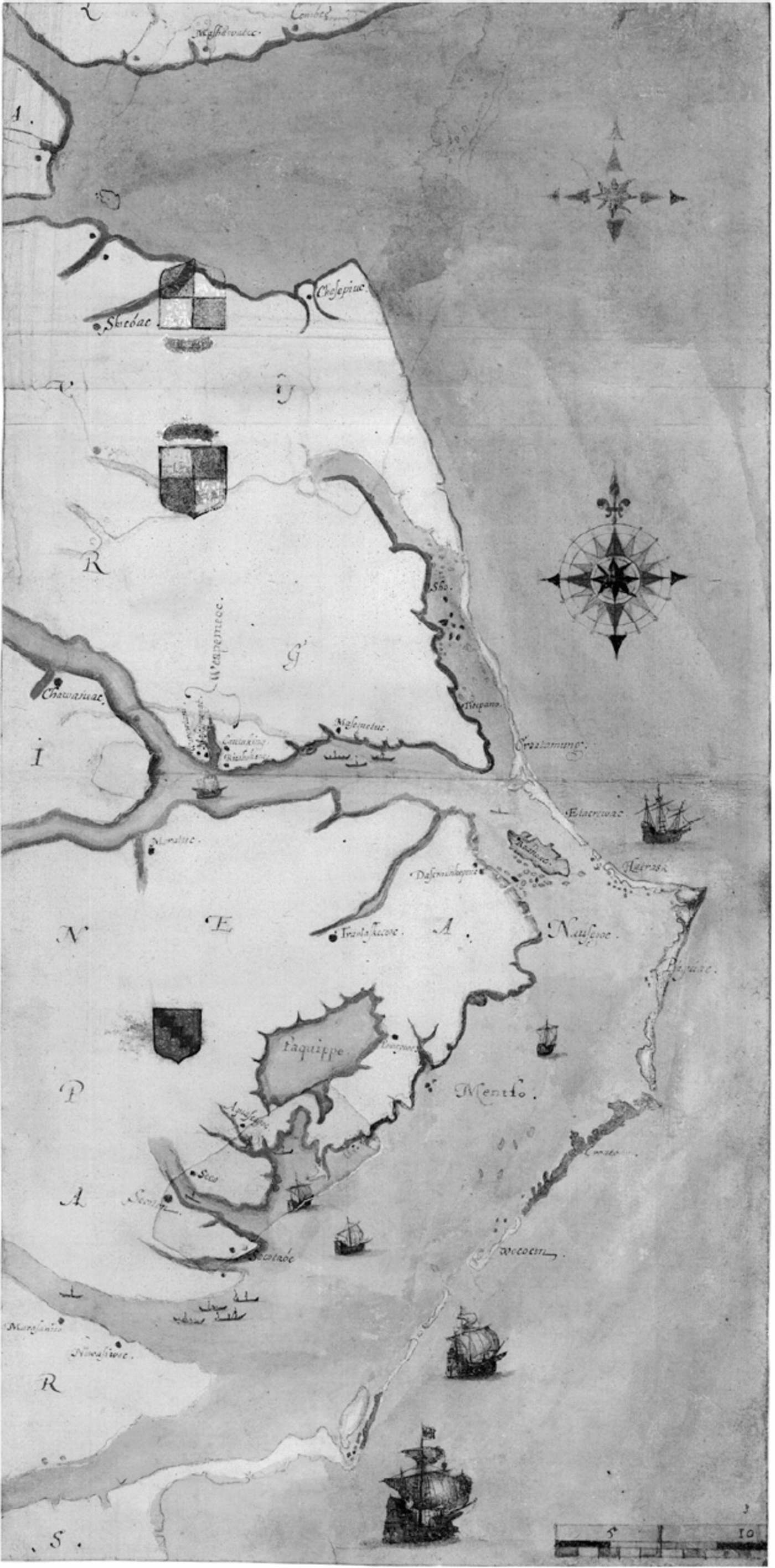
Figure 8. John White and Thomas Hariot. “La Virginea Pars,” 1586. Department of Prints and Drawings, 1906,0509.1.3. Courtesy of the Trustees of the British Museum.
Ralegh learned much about colonization while sailing on the expeditions of his elder half-brother, and Gilbert’s legacy lived on at Ralegh’s Roanoke colony in a number of ways, from its location at the mid-latitudes of North America to the thorough ethnographic studies of Algonquian culture conducted by Thomas Hariot. In place of Bavin, Ralegh enlisted Hariot and John White to map his new colony. Within weeks of their landing in September 1585, they made a preliminary sketch of the Roanoke region, the earliest extant map completed in the Americas by an Englishman.Footnote ,tsup Over the next two years the duo created the “La Virginea Pars” map and a detailed map of the eastern coastline. The latter displays Ralegh’s ships off of the coast, and the cartographers distended the Roanoke region to magnify Ralegh’s colony, much as Lok had narrowed the Atlantic to make North America more attractive. In the extreme northeastern corner of their map, Hariot and White included Gilbert’s “Noram[bega],” which is cut off by the map’s edge. The other map is an exceptionally exact depiction of Roanoke and its surroundings, complete with a scale of leagues, indications of shoals, and several Native American place names. The amended coastline epitomizes the cartographers’ concern for accuracy, and seven of Ralegh’s ships, his arms, and the royal arms firmly established ownership of the land.Footnote 133 Just as Gilbert had intended, Ralegh’s maps supported his claim to the area and advertised his colony to the English public.
When Gilbert began preparing his expedition in 1580, England controlled no territory beyond the British Isles, and North America remained a largely unknown land. Within fifty years thousands of English people had ventured west, and maps played a significant role in this exodus. For Ralegh, maps made his colony known in England and supported his authority in the region. Throughout the early seventeenth century, Jamestown investors issued an array of promotional works that contained maps, which supplemented each text and served as visual proof of the colony’s success.Footnote 134 Gilbert helped engender this chain of advances in map usage, though he was hardly alone in improving England’s map consciousness. Gilbert, Dee, Hakluyt, and their associates were taking part in a far-reaching transition that expanded well beyond a single expedition, as English cartography rapidly advanced at the end of the sixteenth century.Footnote 135
Yet their specific actions broadened the functions of maps in England’s endeavor to colonize the Americas. No longer would explorers rely solely upon foreign charts to direct their voyages. The expedition’s premature attempt to use navigational instruments to improve mapping also foreshadowed the cartographic advances of the next century. Gilbert’s promotional maps presented North America as the ideal land to accommodate the English expansion that soon followed. He showed the versatility of maps in their ability to convey vital information back to England and to solicit the support of investors and the Crown. That Gilbert failed to establish his colony makes it easy to discount his expedition, but he clearly helped establish cartography as a fundamental component of colonization.


