INTRODUCTION
The remnants of human activity are inscribed across many Pacific islands in the form of built landscapes, defined as durable earthen and stone architecture. These constructed landscapes speak to the extent and nature of land use in the past. The acquisition and analysis of lidar (light detection and ranging) datasets has provided a clearer image of the scale of landscape alteration and built environment, particularly of tropical environments that rapidly revert to dense forested ecosystems (McCoy et al. Reference McCoy, Asner and Graves2011; Quintus et al. Reference Quintus, Clark, Day and Schwert2015a, Reference Quintus, Day and Smith2017; Freeland et al. Reference Freeland, Heung, Burley, Clark and Knudby2016; Bedford et al. Reference Bedford, Siméoni and Lebot2018; Cochrane and Mills Reference Cochrane and Mills2018; Jackmond et al. Reference Jackmond, Fonoti and Tautunu2018, Reference Jackmond, Fonoti and Tautunu2019; Comer et al. Reference Comer, Comer, Dumitru, Ayres, Levin, Seikel, White and Harrower2019). In each case of application, the magnitude of land use documented has exceeded that which was once thought. While lidar has been influential for illustrating the magnitude of landscape construction, it supports only coarse-grained temporal analysis at best. The temporal patterning of landscape construction can address a variety of questions beyond how populations organized themselves spatially. The construction and expansion of built landscapes are markers of population expansion and political change, as the increased presence of architecture is dependent on increased labor expenditures that result from demographic needs (e.g., houses or agricultural expansion) and social pressures (e.g., monumental architecture). Furthermore, the construction of built landscapes defines movement into new environmental settings that have novel selective pressures. Inland settlement on volcanic slopes often required the construction of terracing (e.g., Lepofsky Reference Lepofsky1994) and agriculture in leeward areas was facilitated by the construction of walls or embankments that block prevailing winds (Ladefoged et al. Reference Ladefoged, Graves and McCoy2003). Earthen and stone architecture is nearly ubiquitous across Oceania, and resolving their chronologies is key to elucidating changing land use patterns and social relationships.
Robust knowledge of the chronological development of built landscapes is limited for many locations in Oceania. One of these places is the Sāmoan archipelago (see Carson Reference Carson2014 for summary). Located at the boundary between the eastern and western Pacific, the archipelago is conventionally viewed as part of the homeland from which populations would settle East Polynesia (Kirch and Green Reference Kirch and Green2001). The lack of temporal information related to population expansion, political change, and general ecological engineering for Sāmoa hampers the investigation of the context within which populations were migrating outside the region (see Carson Reference Carson2006). Recent archaeological research on the island of Ta‘ū in the Manu‘a Group of American Sāmoa adds important data to this discussion. We employ 35 AMS radiocarbon determinations from the northeast side of the island to model the construction ages of 25 terraces and linear mounds. From these 25 features, we generate tempo plots to assess the timing and trajectory of landscape engineering across our project area.
The Chronology of Built Landscapes in Sāmoa
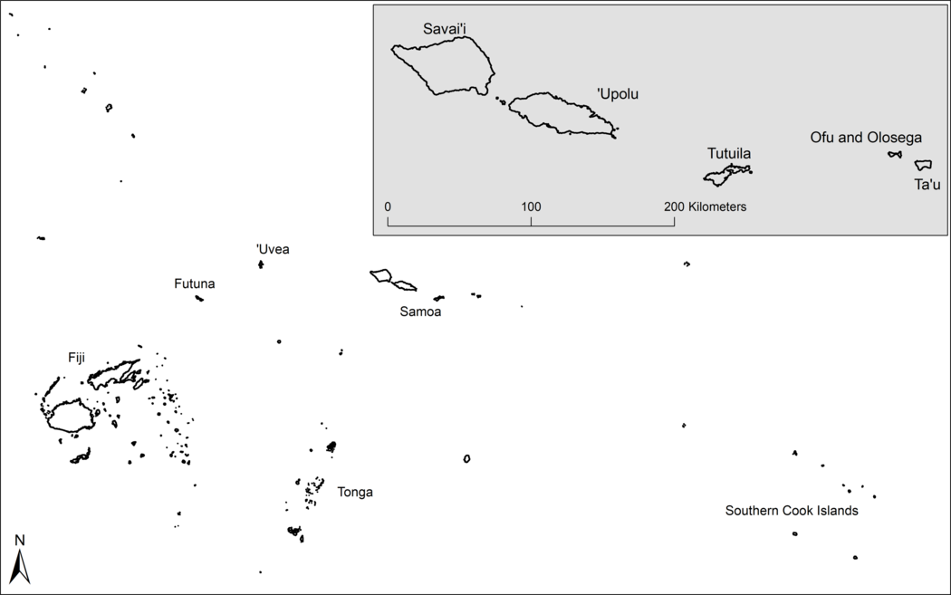
The Sāmoan archipelago lies in the central Pacific within the cultural area of West Polynesia (Figure 1). The archipelago is presently split into two geopolitical units: the independent state of Sāmoa in the west and the U.S. territory of American Sāmoa in the east. The former includes the largest islands of the archipelago, ‘Upolu and Savai‘i, along with the smaller islands of Manono and Apolima. American Sāmoa is constituted by the islands of Tutuila, Aunu‘u, Ofu, Olosega, and Ta‘ū. The latter three islands define the eastern boundary of the archipelago and form the Manu‘a Group, roughly 100 km away from Tutuila.

Figure 1 The Sāmoan archipelago and other named locations in the Fiji-West Polynesia region. The Southern Cook Islands represent the geographical beginning of East Polynesia.
The various islands of Sāmoa were settled between 2500–2800 years ago by populations moving into West Polynesia from the west (e.g., Melanesia) (Petchey Reference Petchey2001; Cochrane et al. Reference Cochrane, Rieth and Dickinson2013; Clark et al. Reference Clark, Quintus, Weisler, St Pierre, Nothdurft and Feng2016; Petchey and Kirch Reference Petchey and Kirch2019), and the most visible components of the archaeological record are earthen and stone structuresFootnote 1. The morphology of this durable architectureFootnote 2 is variable across the archipelago. In the western islands, mounds, stone walls, raised-rim depressions, and ditches dominate the landscape, along with terraces on the hillslopes of valleys (Davidson Reference Davidson, Green and Davidson1974a; Holmer Reference Holmer, Jennings and Holmer1980; Martinsson-Wallin Reference Martinsson-Wallin2016; Sand et al. Reference Sand, Baret, Bole, Ouetcho and Sahib2018; Jackmond et al. Reference Jackmond, Fonoti and Tautunu2019). In the eastern islands, terracing is common in the interior uplands with more limited distributions of stone walls, ditching, earthen depressions, and few mounds (Clark and Herdrich Reference Clark and Herdrich1993; Pearl Reference Pearl2004; Quintus Reference Quintus2011, Reference Quintus2015; Quintus et al. Reference Quintus, Day and Smith2017). The intensive labor required for the construction of at least some of these structures is thought to signify the presence of increasingly centralized political systems (Holmer Reference Holmer, Jennings and Holmer1980; Jennings et al. Reference Jennings, Holmer and Jackmond1982; Clark Reference Clark1996; Martinsson-Wallin Reference Martinsson-Wallin2016; Quintus et al. Reference Quintus, Allen and Ladefoged2016) and the transition to the Sāmoan cultural context of the historic period (Green Reference Green, Ladefoged and Graves2002).
The construction of durable architecture may have begun as early as the middle of the 1st millennium AD. Dated charcoal samples collected from under some mounds raise the possibility of 1st-millennium AD construction, but the relationship between the dated material and the construction of architecture is ambiguous (Hewitt Reference Hewitt, Jennings and Holmer1980: 41). Terraces may also have been built during the 1st millennium AD in Falefa valley on ‘Upolu (Davidson Reference Davidson, Green and Davidson1974a: 229; Ishizuki Reference Ishizuki, Green and Davidson1974) and on Tutuila (Ayres and Eisler Reference Ayres and Eisler1987: 72; Carson Reference Carson2006), but these dates are from charcoal either within the terrace or below structural features and, thus, represent maximum ages for construction (Carson Reference Carson2005: 216–217). More expansive terracing has been dated to the 2nd millennium AD from the uplands of Tutuila and Manu‘a (Best et al. Reference Best, Leach and Witter1989; Clark Reference Clark1993; Quintus Reference Quintus2015), with extensive but undated distributions of these features known throughout American Sāmoa (Quintus et al. Reference Quintus2015, Reference Quintus, Day and Smith2017; Cochrane and Mills Reference Cochrane and Mills2018). Similarly, dates clearly associated with earthen and stone mounds or platforms indicate construction of these features in the 2nd millennium AD (Jennings and Holmer Reference Jennings, Holmer, Jennings and Holmer1980; Martinsson-Wallin Reference Martinsson-Wallin2016). Durable architecture becomes more elaborate over time with larger mounds and more specialized features (i.e., star mounds) apparent after the 15th century AD (Green Reference Green1969, Reference Green, Ladefoged and Graves2002; Green and Davidson Reference Green and Davidson1974: 218; Davidson Reference Davidson, Green and Davidson1974b: 155–156; Jennings and Holmer Reference Jennings, Holmer, Jennings and Holmer1980: 5; Jennings et al. Reference Jennings, Holmer and Jackmond1982; Clark Reference Clark1996; Martinsson-Wallin and Wehlin Reference Martinsson-Wallin and Wehlin2010).
These results highlight minimal earthen and stone construction until at least the late 1st millennium AD. This would seem to suggest that the population and labor necessary to engineer these landscapes and, by extension, the organizational apparatus to manage said labor, did not emerge until the last millennia in the Sāmoan archipelago. This temporal patterning is reasonably consistent with data from other areas of West Polynesia, namely Tonga, Futuna, and ‘Uvea, where the built environment dates to the 2nd millennium AD (Burley Reference Burley1998; Kirch Reference Kirch1988, Reference Kirch1994; Sand Reference Sand1998; Freeland Reference Freeland2018). These data seem to suggest a region-wide pattern of population growth and changes in political organization.
However, several authors have noted problems associated with available chronological data from Sāmoa (Rieth and Hunt Reference Rieth and Hunt2008; Wallin et al. Reference Wallin, Martinsson-Wallin and Clark2007). Wallin et al. (Reference Wallin, Martinsson-Wallin and Clark2007), for instance, note that researchers in Samoa have tended to date activity that occurred on the surface of architecture rather than the construction of that architecture. Even when radiocarbon dates from material that was underneath architectural features are available, providing a maximum rather than minimum age of construction, few features have been dated within a site or landscape. This limits the ability of archaeologists to explore changing tempos of construction in any systematic way. Finally, a large corpus of dates may be erroneous due to their association with the Gakushuin Laboratory. As noted by Spriggs (Reference Spriggs1989), some of these dates are presumed to be accurate but it is unclear which are and which are not. The Gakushuin Laboratory dates used extensively by Green and Davidson (Reference Green and Davidson1974) on ‘Upolu and Savai‘i create chronological uncertainty for other forms of architecture as well, in particular a ditch embankment associated with a fortification dated to the 1st millennium AD (Green and Davidson Reference Green and Davidson1974: 215). The chronology of these sites remains uncertain until they can be redated.
This problem is not unique to Sāmoa. The construction of architecture can rarely be dated directly in Oceania, except for U/Th coral dates on construction material (Sharp et al. Reference Sharp, Kahn, Polito and Kirch2010). Often, what archaeologists depend upon are dates from before or after such construction events, with an unknown amount of time elapsing between the dated events and the construction of the feature, or vice versa. This creates some level of ambiguity when interpreting dates from architectural contexts. Recent theoretical discussion and methodological improvements in the dating of archaeological sequences generally have sought to reduce this ambiguity and archaeologists have developed ways to analyze the temporal trends within classes of architecture more systematically. Several researchers have demonstrated the need to collect and date material from contexts that can be stratigraphically compared to the architecture of interest (Kahn Reference Kahn2005; Wallin et al. Reference Wallin, Martinsson-Wallin and Clark2007; Allen Reference Allen2009; Dye Reference Dye2011). Ideally, material can be dated from contexts that stratigraphically bound the archaeological manifestation of construction. An age of construction can then be estimated by incorporating these constraints into Bayesian models. The usefulness of these Bayesian models can be limited by the fact that some features are associated with either TAQ (Terminus ante quem) or TPQ (Terminus post quem) dates, but not both. In these cases, posterior probability age estimates of construction exhibit long tails on either the left or right side of their HPD (highest posterior density) estimates.
Fortunately, the results of Bayesian calibration for each architectural feature can be input into software to model the joint posterior distributions of feature construction (Dye Reference Dye2016; Marsh et al. Reference Marsh, Kidd, Ogburn and Durán2017; Banks et al. Reference Banks, Bertran, Ducasse, Klaric, Lanos, Renard and Mesa2019; DiNapoli et al. Reference DiNapoli, Rieth, Lipo and Hunt2020). The calculation of joint posterior distributions aims to assess the number of events that have occurred before some date by querying valid chronological estimates of feature construction that are produced through MCMC (Markov chain Monte Carlo) routines at the heart of Bayesian calibration. In doing so, these methods create a product (i.e., tempo plot) that estimates the cumulative number of archaeological events as a group rather than considering each instance of feature construction separately.
If we are to understand the rise of labor cooperation and changing political systems in a more nuanced way, accurate chronologies of surface architecture should be developed to track the timing and tempo of landscape modification using these recent methodological advances. Data generated from Ta‘ū remedy this situation by intensively dating a suite of surface architecture that speaks to the timing and tempo of construction on the island.
Ta‘ū Island and the Project Area
Ta‘ū is the largest island of the Manu‘a group (36 km2) and is also the geologically youngest (McDougall Reference McDougall2010). The island is constituted by a narrow coastal plain with limited reef development separated from the interior uplands by remnant sea cliffs. The coastal plains were the locus of early settlement, which began on Ta‘ū no later than 2300 calBP (Hunt and Kirch Reference Hunt and Kirch1988) and most likely in line with Ofu around 2600–2700 calBP (Kirch Reference Kirch, Kirch and Hunt1993; Clark et al. Reference Clark, Quintus, Weisler, St Pierre, Nothdurft and Feng2016; Petchey and Kirch Reference Petchey and Kirch2019). Gentle slopes lie directly inland of these remnant sea cliffs in some locations, ranging between 5–20°. It is in these areas that pre-contact surface architecture has been recorded (Hunt and Kirch Reference Hunt and Kirch1988; Clark Reference Clark1990; Klenck Reference Klenck2016; Quintus et al. Reference Quintus, Day and Smith2017; Motu Reference Motu2018) and is apparent in lidar-derived imagery.
The data described and analyzed in this paper derives from research undertaken in the northern half of Ta‘ū inland of Fitiuta on the east side of the island in what is referred to as the Luatele site (Quintus et al. Reference Quintus, Day and Smith2017; Motu Reference Motu2018) (Figure 2). The goal of the project was to address the timing and tempo of the construction of surface architecture in the interior stretches of the island. Surface architecture in the location consists primarily of stone-faced earthen terraces along with stone and earthen linear mounds or walls. More unique, and less common, features identified included stone mounds, depressions, and enclosures.

Figure 2 Ta‘ū Island with the location of Luatele labelled. Contour lines are drawn in 20 m intervals.
The Luatele site, which covers ~200 hectare (ha) in the northeast quadrant of the island, is bounded by remnant sea cliffs to the north, dissected stream beds on the east and west, and by two volcanic craters to the south. The project discussed herein examined the distribution and temporal development of surface architecture across ~130 ha downslope of these craters wherein a dense concentration of terracing and stone linear mounds/walls are located. Three hundred and twelve terraces have been recorded through pedestrian survey, most intensively within four survey transects (Figure 3). Most of these terraces were constructed of earthen fill with a stone boulder or cobble facing. Rounded to sub-angular basalt cobbles and gravel were found on the majority of these features but preserved formal floor pavings are relatively rare as are house outlines/platforms. The clear presence of house outlines and floor pavings on some, however, does indicate residential activities. The degree of labor invested in the construction of other large terraces at lower elevations and slopes seems also to speak to a residential function based on the labor required for construction. Smaller terraces on higher slopes may have served as either structural foundations for short-term field shelters or as spaces for cultivation. Ninety-three stone and earthen linear mound segments have been recorded amongst these terraces that range in length from less than 10 m to over 1.6 km. Most of these features run perpendicular to the slope and seem to create boundaries around and between terraces. Multiple segments of eight of these features running perpendicular to the slope have been recorded in the intensive survey transects running from near the cliff edge on the downslope boundary of the site to near one of the two craters at the upslope. The result of this configuration is a pie-like pattern centering at the two craters. These features were constructed by the mounding or coarse stacking of boulders and cobbles in most cases. Formal stacking was documented for some of these features, though this was generally regarded as evidence of modern rejuvenation or recent construction (this is confirmed with radiocarbon dates for at least one feature). In a small number of cases, two linear mounds run parallel and may have served to define paths; the longest linear mound feature in the site is one such double-walled feature.
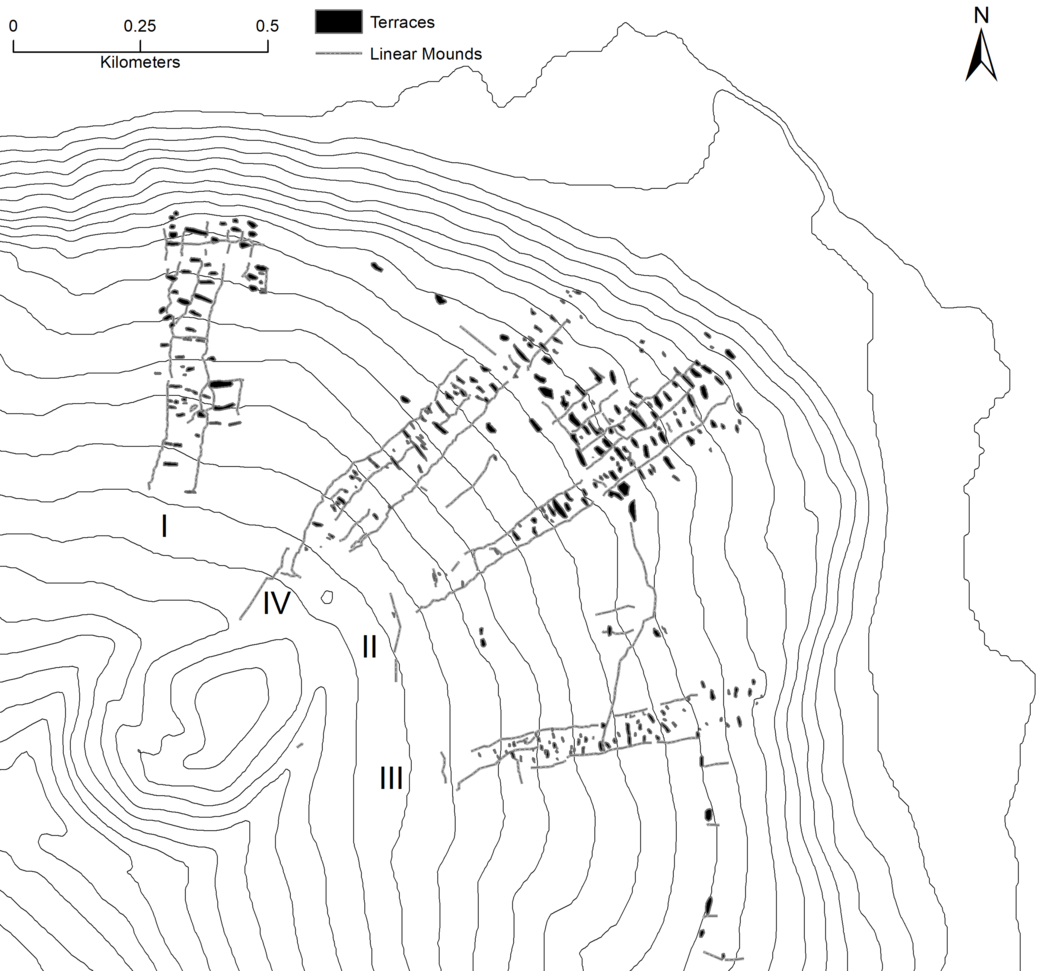
Figure 3 Distribution of field-recorded terraces and linear mounds in Luatele. Contour lines are in 20 m intervals. The majority of these features were recorded within four transects (roman numerals). Field recorded features are a sample of features in Luatele.
METHODS
Methods were directed toward collecting charcoal from positions that would provide chronological information related to the construction of the associated structure (following methods in Allen Reference Allen2009; Field et al. Reference Field, Kirch, Kawelu and Ladefoged2010; Dye Reference Dye2011). Excavations employed two strategies: test pits and controlled excavations (Figure 4). Test pits (30 cm × 30 cm, 50 cm × 50 cm) were dug directly into the facing of terraces or through the side of linear mounds. We chose to deconstruct excavated features in most cases (Figure 4c). Deconstruction of a feature allows the researcher to more directly observe datable material gathered from beneath intact architecture rather than from below wall fall or from otherwise disturbed contexts. Datable material from beneath a feature may also be obtained by excavating adjacent to the feature and then, subsequently, digging horizontally underneath the feature. A small number of features were excavated in this way when deconstruction would adversely impact the integrity of the entire feature (Figure 4a). The goal of test pit excavations was to acquire datable material beneath terrace retaining walls and beneath the basal stones of linear mounds, and these test pits were terminated after the collection of charcoal from contexts clearly below the associated structure. Controlled excavations (1 m × 1 m, 2 m × 1 m) were dug within 10 features (eight terraces and two linear mound segments). These controlled units were excavated in natural strata using 10 cm arbitrary levels and were terminated only after reaching a sterile substratum or bedrock (Figure 4b). Charcoal collected for dating was from stratigraphic positions below terrace construction fill or retaining walls and from sub-surface combustion features associated with the use of terraces. Bioturbation caused by tree growth and earthworm activity was noted during test pit excavation of linear mounds and terrace retaining walls, requiring careful selection of charcoal sampling from in situ contexts below such horizons. The focus of sampling was, therefore, charcoal from clearly in situ soils, though the presence of some post-bomb (modern) dates might suggest otherwise in a few instances. All excavated features were field mapped prior to excavation.

Figure 4 The different methods of excavation used in Luatele: digging adjacent to a feature and then horizontally under a features (a., Wall 93), controlled unit excavation (b., Terrace 98), and test pit deconstruction (c., Terrace 311). Note the boulder foundation of Terrace 98 (b.). It was from the interface between this boulder foundation and the overlying terrace fill that charcoal was sampled for dating. We interpret this radiocarbon determination to date the construction of the feature given this context.
Charcoal samples (n = 35) were dated using AMS at the University of Arizona Accelerator Mass Spectrometry Lab (AA) and the University of Georgia Center for Applied Isotope Studies (UGAMS). Each determination was classified as a TPQ or a TAQ based on their stratigraphic association with structures. Dates on samples from below a terrace retaining wall or linear mound were classified as TPQ because they are older than the event of terrace construction on stratigraphic grounds. In contrast, determinations from combustion features on terrace surfaces were classified as TAQ because the construction of features (e.g., hearths) was dependent on the presence of the terrace; therefore, the terrace had to have been built prior to the use of the combustion feature. TAQ determinations were not available for linear mounds. A justification for date assignments is included in Table 1. All charcoal was identified to the lowest taxonomic level possible. Short-lived taxa were sought for dating (see Allen and Huebert Reference Allen and Huebert2014), but material that may have some inbuilt age was dated in TPQ contexts when short-lived material was unavailable. Dated charcoal from TPQ contexts provide at best a maximum age of construction and inbuilt age does not change that fact. Short-lived (niu, Cocos nucifera endocarp) or medium-lived (e.g., fau, Hibiscus tiliaceus) material was dated from TAQ contexts.
Table 1 Radiocarbon dates from Luatele.

Construction ages of individual terraces and linear mounds were estimated by a series of Bayesian models in OxCal 4.3 (Bronk Ramsey Reference Bronk Ramsey2017) using the IntCal13 calibration curve (Reimer et al. Reference Reimer, Bard, Bayliss, Beck, Blackwell, Bronk Ramsey, Buck, Cheng, Edwards, Friedrich, Grootes, Guilderson, Haflidason, Hajdas, Hatté, Heaton, Hoffmann, Hogg, Hughen, Kaiser, Kromer, Manning, Niu, Reimer, Richards, Scott, Southon, Staff, Turney and van der Plicht2013). While the Sāmoan archipelago is in the Southern Hemisphere, its position in the Intertropical Convergence Zone allows the use of the Northern Hemisphere calibration curve (Petchey and Addison Reference Petchey, Addison, Addison and Sand2008). Each feature was modeled as a separate sequence with multiple phases and boundaries in order to estimate the timing of each construction event. All feature sequences included start boundaries that marked the beginning of cultural deposition at that location. This was followed by a pre-architecture phase, within which was placed TPQ determinations associated with that structure. The boundary command was then used to model the construction of the feature, which was constrained by a post-construction phase that included all TAQ determinations. An upper constraint of AD 1900 ± 5 was imposed on all sequences as this date corresponds with the work of Augustin Krämer who listed all settlements on the island but did not document habitation or activity in Luatele (Krämer Reference Krämer1902–1903). His only reference to inland settlements is to abandoned settlements inland of Ta‘ū Village. Therefore, it is assumed the site was largely abandoned by the time he undertook his work. The general form of each construction sequence is as follows:
Pre-Feature Start (Boundary) > Pre-Feature TPQ (Phase) > Feature Construction (Boundary) > Post-Feature TAQ (Phase) > AD 1900 (Before [C_Date ±5])
The results of Bayesian modeling were used to develop tempo plots. Tempo plots were generated of feature construction using the ArchaeoPhase package (Philippe et al. Reference Philippe, Vibet and Dye2020) in R software (R Core Team 2020) with the raw MCMC output of each “Feature Construction (Boundary)” from the Bayesian models as input. All OxCal models and R code are available in the Supporting Information.
RESULTS
All radiocarbon dates obtained from Luatele were associated with surface architecture. Four of these determinations provided post-bomb age determinations. In one instance, this was expected and confirms the recent construction of some of the architecture (AA-112174). It is possible that the material dated was intrusive or that modern rejuvenation of pre-contact features has introduced modern charcoal under features in the other cases (i.e., AA-112172; AA-113191). Certainly, this small number of post-bomb dates is not surprising given modern land use dating from the 1980s and the number of earthworms in the site. The 31 remaining determinations are from 25 distinct features: 15 terraces and 10 linear mounds. All dates associated with linear mounds are TPQ dates (n = 10). Six determinations associated with terraces are TAQ dates, 14 determinations are TPQs, and one determination appears to date the construction of the feature directly (T98 [UGAMS-43803]).
Only three unmodeled determinations (10% of all dates, excluding post-bomb) possess ranges that are within or extend into the 1st millennium AD. All these dates are TPQ dates associated with terraces. Fifteen unmodeled determinations (50% of those associated with architecture, excluding post-bomb) have probability distributions that extend into the proto-historic (cal AD 1722) and historic (cal AD 1830) period. Eight of these are from contexts associated with linear mounds (80% of dates associated with linear mounds, excluding post bomb). Most of the artifacts recovered through excavation would suggest the construction of most features within the pre-contact portions of these distributions. With this said, at least one non-dated terrace was built during the historic period as an historical artifact was found within the retaining wall of the feature—a piece of late 18th to early 19th-century ceramic (blue and white “Willow” pattern transfer printed pearlware).
Construction Estimates and the Tempo of Change
Upper and lower chronological constraints were obtained from five features and one feature is dated directly by a determination (Table 1). The remaining 19 features are constrained by either a TPQ or a TAQ and estimates for the construction of these features exhibit tails on one side of the associated 95.4% HPD distribution. Based on modeled 95.4% HPD construction dates at Luatele, three terraces were plausibly built before the 11th century (20%) and a total of 10 terraces were plausibly built before the 16th century AD (67%). The remaining five were built after. The distribution of modeled dates of linear mound construction are markedly different. Of the nine linear mounds for which the age of construction was modeled, only two plausibly date before the 17th century AD (22%).
The calculation of tempo plots clarifies temporal patterns by synthesizing the results of Bayesian calibration (Figures 5 and 6). The tempo plot of terrace construction in Luatele illustrates that terrace construction began by the 9th century AD though it may be as early as the 4th century AD. The earliest date is a TPQ from T117. The position of this date underneath the terrace, the potential of inbuilt age in the taxa being dated, and the large difference between the TAQ and TPQ dates from this terrace all suggest the presence of temporal lag between the TPQ and the date of terrace construction. Because of this, we favor a date of first construction closer to the 9th century than the 4th century AD. The rate of construction in Luatele increased in and after the 13th century (Figure 5). The shape of the tempo plot implies continuous construction through the beginning of the historic period. While the shape of the linear mound tempo plot is similar, the chronology is quite distinct. Linear mound construction may have begun as early as the 12th century, but it appears to be limited until the 17th and 18th centuries, after which a rapid increase in the rate of construction occurred (Figure 6). Unlike the tempo of terrace construction, the shape of the linear mound tempo plot indicates a single late peak for construction.

Figure 5 Tempo plot of terrace construction at Luatele. The y-axis is the cumulative number of terrace construction events. The x-axis is in calendar years AD.

Figure 6 The tempo of linear mound construction at Luatele. The y-axis is the cumulative number of linear mound construction events. The x-axis is in Calendar years AD.
Land use and architectural construction (and possibly remodeling) continued into the historic period. Not only is this apparent in the tempo plots, but artifacts collected from within a terrace retaining wall, notably an early 19th century AD English ceramic sherd, provide a definitive indication of a level of continuity in land use between the pre- and post-contact cultural periods in Luatele. Renewed land use has continued to extend and otherwise modify the built landscape as indicated by modern infrastructure and post-bomb radiocarbon dates.
DISCUSSION AND CONCLUSIONS
Teasing out the temporal and spatial patterning embedded in palimpsest landscapes has been a perennial problem in Oceania (Field et al. Reference Field, Ladefoged and Kirch2011), including in Sāmoa (Wallin et al. Reference Wallin, Martinsson-Wallin and Clark2007). A focus on acquiring data to constrain the chronology of events of construction, rather than trying to date the construction directly, is effective when paired with Bayesian models and other computational methods (Dye Reference Dye2016). Such techniques allow for the development of chronological models at the landscape scale, which is important for understanding when construction took place and the relationships between features when analyzed at larger spatial scales. The use of these techniques here allows for the assessment of changing land use and modification on Ta‘ū Island.
A single radiocarbon date indicates commencement of activity in Luatele by the beginning of the 1st millennium AD, though the sparseness of evidence dating to this time hints that activity was relatively limited. While the radiocarbon date represents a TPQ for terrace construction, the context of this early date, specifically its proximity to bedrock and the long-lived nature of the taxa dated, suggests some temporal lag between this date and the construction of the terrace. The corpus of data from Luatele supports the earliest construction of earthen and stone structures by the 8th to 10th centuries AD, roughly 1600–1800 years after the initial settlement of Manu‘a. The construction of architecture demonstrates more intensive and permanent use of the interior landscape by the late 1st millennium and into the 2nd millennium AD. The tempo of terrace construction events from Luatele suggests a continuous but incremental process of infrastructural, and presumably population, growth in the site through the 2nd millennium AD. No clear surge in construction is especially evident at any time.
There are marked differences between the tempo of construction of terraces and linear mounds. It is conceivable that both feature types began to be constructed at the beginning of the 2nd millennium AD but the rate of construction of linear mounds increased drastically in the 17th and 18th centuries AD. The spatial configuration and morphology of these features indicate their use as boundary markers (see analogy in Ladefoged et al. Reference Ladefoged, Graves and McCoy2003; Kirch Reference Kirch1994), and the rapid construction of these boundary markers hints at relatively rapid changes to land tenure in the site. The construction of these linear mounds following centuries of terrace construction appears to be a response to a progressively more nucleated and dense settlement landscape by the 17th and 18th centuries AD. That many of these linear mounds extend across large areas of the site, either horizontally or vertically, is indicative of a level of community coordination not necessary for the construction of more spatially limited terracing dispersed across Luatele in earlier times.
Temporal patterns of landscape modification in the interior uplands of Ta‘ū overlap with those of the expansion of habitation on the north coast of the island. TPQ dates for house outlines and foundations on the north coast suggest construction in the late 1st millennium AD and the 2nd millennium AD, indicating both the use of a recent geomorphic landform and the expansion of populations (Cleghorn and Shapiro Reference Cleghorn and Shapiro2000). Habitation on the coastal plain continues through the rest of the cultural sequence. These data indicate that the expansion of population activities visible through the built landscapes in the interior uplands was part of a larger process of demographic expansion that included the coastline. This seems to contrast with the situation on the adjacent island of Ofu. There, the construction of terracing in the interior uplands, which occurs also at the end of the 1st millennium AD or beginning of the 2nd millennium AD, was met by what appears to be the more dispersed use of the coastal plains (Quintus et al. Reference Quintus, Clark, Day and Schwert2015b).
Regional Considerations
The chronology of durable architecture on Ta‘ū is consistent with that of the built landscapes identified across Sāmoa at a broad temporal scale. It is increasingly clear that the construction of architecture occurred across the archipelago by the late 1st millennium and the beginning of the 2nd millennium AD (Carson Reference Carson2014). Terrace construction is now evident in Manu‘a by this time on multiple islands (Quintus Reference Quintus2015; this paper) and terracing may date slightly earlier than other forms of construction overall (Davidson Reference Davidson, Green and Davidson1974a; Carson Reference Carson2006, Reference Carson2014). Carson (Reference Carson2014) has argued that earthen terrace construction declined in the last 1000 years, but our results indicate continuous and, likely, increasing rates of construction since the 13th century AD. While this may not apply to the rest of the archipelago, there are two reasons it may. First, few terraces have been dated in the archipelago even though they were extensively built (Cochrane and Mills Reference Cochrane and Mills2018; Day Reference Day2018), and second, at least some terracing is known to have been constructed on Tutuila into the 2nd millennium AD (Best et al. Reference Best, Leach and Witter1989). The earliest earthen and stone mounds were constructed at the turn of the 1st and 2nd millennium AD on ‘Upolu and Savai‘i (Hewitt Reference Hewitt, Jennings and Holmer1980; Holmer Reference Holmer, Jennings and Holmer1980; Wallin et al. Reference Wallin, Martinsson-Wallin and Clark2007), with subsequent construction, modification, and use of these features occurring until historic contact (Wallin et al. Reference Wallin, Martinsson-Wallin and Clark2007).
A late 1st millennium or early 2nd millennium AD origin for earthen and stone architecture elsewhere in West Polynesia, most notably Tonga (Burley Reference Burley1998; Kirch Reference Kirch1988; Clark et al. Reference Clark, Burley and Murray2008; Clark and Reepmeyer Reference Clark and Reepmeyer2014; Freeland Reference Freeland2018), Futuna (Kirch Reference Kirch1994), and ‘Uvea (Sand Reference Sand1998), has also been noted. That there is such regional patterning suggests shared processes of population growth as well as social influence and interaction (Kirch Reference Kirch1988; Sand Reference Sand1998). The latter is perhaps best documented in the construction of monumental architecture during the 14th and 15th centuries AD as a mechanism of hegemonic expansion by Tongans (Burley Reference Burley1996; Kirch Reference Kirch1988), while the former is represented well by the spread of burial mounds throughout Tongatapu and the construction of house mounds, platforms, and terraces across many Sāmoan landscapes.
These trajectories seem to mark demographic changes that began at the archipelago- and region-wide scale at the turn of the 2nd millennium AD. This archaeological evidence is supported by recent genetic reconstruction of population structural history in Sāmoa (Harris et al. Reference Harris, Kessler, Shetty, Weeks, Minster, Browning, Cochrane, Deka, Hawley, Reupena, Naseri, McGarvey and O’Connor2020), suggesting substantial population growth in Sāmoa at this time. This is roughly consistent with other lines of evidence suggesting population reconfiguration in West Polynesia during the late 1st millennium and early 2nd millennium AD (Addison and Matisoo-Smith Reference Addison and Matisoo-Smith2010). These initial demographic changes in West Polynesia are roughly contemporaneous with the settlement of East Polynesia (Rieth and Cochrane Reference Rieth, Cochrane, Cochrane and Hunt2018), presumably from the wider West Polynesia region. Sear et al. (Reference Sear, Allen, Hassall, Maloney, Langdon, Morrison, Henderson, Mackay, Croudace, Clarke, Sachs, Macdonald, Chiverrell, Leng, Cisneros-Dozal and Fonville2020) have proposed a correlation between the settlement of some East Polynesian islands and a prolonged regional drought in the late 1st millennium AD. We propose that this drought could have had an influence on the settlement reconfigurations we document on Ta‘ū. Coastal regions would be at greater risk in drought conditions, given the orographically-driven rainfall of the island. A movement into the interior at this time would have helped to mitigate the immediate effects of the drought.
The tempo of terrace construction on Ta‘ū makes clear that infrastructure was not built all at once and that community growth through the last millennium was continuous if not exponential. Our data do not support a singular event of population increase (demographic explosion). Simply, populations and political hierarchies grew at a faster rate toward the end of the 1st millennium AD than during the first two millennia of West Polynesian history. The temporal associations demonstrated here illustrate the complexity of human movement during this period, with both intra- and inter-island reconfigurations of settlement occurring. The outcome of these processes was a highly engineered landscape.
ACKNOWLEDGMENTS
We thank the people of Fitiuta, especially Eseta Kese and Pastor Fred Scanlan, for hosting us during our research. We thank Logoleo Feagai Logoleo for permission to work in Luatele. We wish also to recognize the contributions of Malone Ieti, Princecharles Faleagafulu, Christina Fu‘afu‘a, Tafa Fuafua, Paulo Paulo, Oceana Te‘i, Arthur Sega, Fafeta‘i Lauofo, Joshua Fu‘afu‘a, Falani Masunu, Visa Vaivai Tiapusua, Brian Vivao, Fa‘afutai Lauofo, Fauato Aukuso, Taumakai Atautia, Jonathon Mauga, Leonard Vivao, Lawrence Fautua, Robert Mauga, J.J. Tanielu, and Achilles Tevasea to the success of this research. We appreciate the helpful comments of David Addison, Tom Dye, Tim Rieth, Robert DiNapoli, and two anonymous reviewers on a previous draft of this manuscript. Finally, we thank the American Samoa Historic Preservation Office, specifically Letitia Peau-Folau, Teleai Christian Ausage, and Lancelot Leutu‘utuofiti Te‘i, for archaeological and logistical support. Logistical assistance was provided by the National Park of American Samoa under permit NPSA-2019-SCI-0001. This research is based upon work supported by the National Science Foundation under Grant No. NSF BCS-1732360.
Supplementary material
To view supplementary material for this article, please visit https://doi.org/10.1017/RDC.2020.60