


INTRODUCTION
In this report we present dating of various archaeological (charcoal, bones, wood) and cultural heritage (art objects) samples from Croatia. They have an identifying number denoted by Z (Zagreb Radiocarbon Laboratory). Most samples were measured by liquid scintillation counter technique using benzene synthesis (LSC-B) (Horvatinčić et al. Reference Horvatinčić, Barešić, Krajcar Bronić and Obelić2004) and they are identified by B code numbers. Some samples were measured by accelerator mass spectrometry (AMS) after graphite was prepared in our laboratory (Krajcar Bronić et al. Reference Krajcar Bronić, Horvatinčić, Sironić, Obelić, Barešić and Felja2010; Sironić et al. Reference Sironić, Krajcar Bronić, Horvatinčić, Barešić, Obelić and Felja2013) and they are identified by A code numbers. Graphite targets were measured at Scottish Universities Environment Research Centre (SUERC) between 2007 and 2013 (up to A642) and since then at University of Georgia, Athens, GA, AMS facility (UGAMS). We use Oxalic Acid II (NIST SRM4990C) as modern standard, and anthracite and Carrara marble as background. All data on samples, sample preparation and measurements are recorded in a relation database ZAGRADA (Portner et al. Reference Portner, Obelić and Krajcar Bronić2010). Laboratory participated in 14C intercomparison VIRI and SIRI studies (Sironić et al. Reference Sironić, Krajcar Bronić, Horvatinčić, Barešić, Obelić and Felja2013; Krajcar Bronić et al. Reference Krajcar Bronić, Horvatinčić and Barešić2015).
14C results are presented as rounded conventional radiocarbon ages. Age calculations follow the conventional protocol (Mook and van der Plicht Reference Mook and van der Plicht1999) based on the Libby half-life of 5570 yr and using AD 1950 as the reference year. Ages and standard deviations (1σ error) of samples are adjusted for stable isotope fractionation to normalized concentration ratio (δ13C = –25‰) according to recommendations in Stuiver and Polach (Reference Stuiver and Polach1977) and using the default δ13C values if not measured. Whenever available, measured δ13C value is also given. Calibrated ages are calculated from non-rounded 14C conventional ages by using the on-line program OxCal v.4.4 (Bronk Ramsey Reference Bronk Ramsey1995, Reference Bronk Ramsey2017; Bronk Ramsey and Lee Reference Bronk Ramsey and Lee2013) with 1σ error (confidence level 68.3%) and IntCal20 atmospheric curve (Reimer et al. Reference Reimer, Austin, Bard, Bayliss, Blackwell, Ramsey, Butzin, Cheng, Edwards and Friedrich2020). When several calendar age ranges are obtained, probability for each interval is given. Probabilities less than 5% are omitted.
Series and sample description follow data obtained by submitters and their description of the work performed at locations published in HAG (2004–2010). When available, the expected ages or period of origin are also given. Figure 1 shows the map of Croatia with the main cities mentioned in sample description.
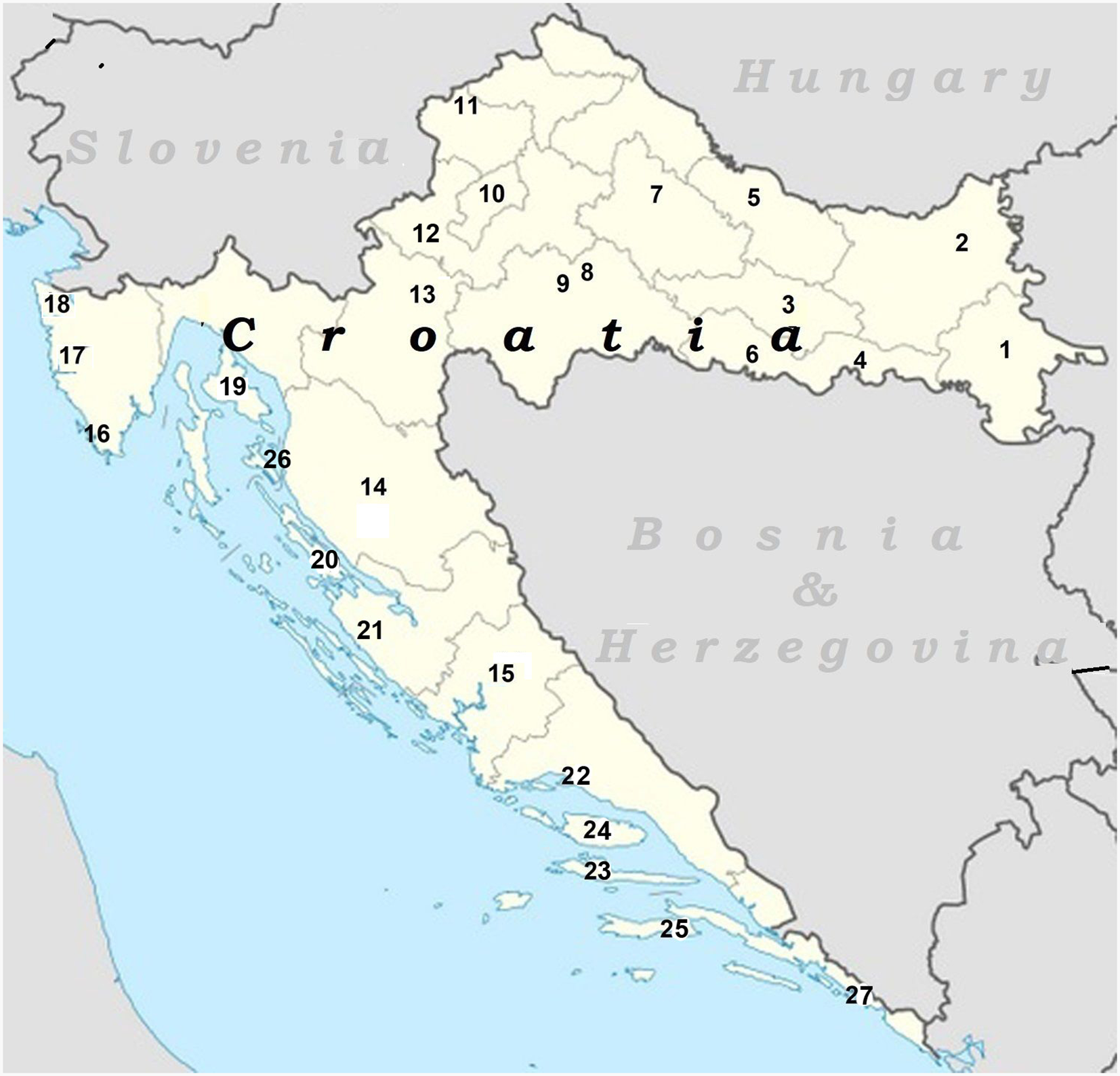
Figure 1 Map of Croatia with the cities mentioned in text: 1—Vinkovci; 2—Osijek; 3—Požega; 4—Slavonski Brod; 5—Virovitica; 6—Nova Gradiška; 7—Bjelovar; 8—Sisak; 9—Petrinja; 10—Zagreb; 11—Veliki Tabor castle; 12—Samobor; 13—Karlovac; 14—Gospić; 15—Knin; 16—Pula; 17—Poreč; 18—Umag; 19—Krk Is.; 20—Pag Is.; 21—Zadar; 22—Split; 23—Hvar Is.; 24—Brač Is.; 25—Korčula Is.; 26—Rab Is.; 27—Dubrovnik.
Continental Croatia
Vinkovci—Sopot Series
Samples of charcoal from systematic excavations at Late Neolithic archaeological site Sopot near Vinkovci, E Croatia (45°15′51″N, 18°46′4″E) (Figure 1, city 1). Continuation of research described in Obelić et al. (Reference Obelić, Krznarić Škrivanko, Marijan and Krajcar Bronić2004). Collected from 2001 to 2006 and submitted 2008 by M. Krznarić Škrivanko.
Comment: (MKŠ) Expected Late Neolithic period. Until 2005 14C analyses of 19 samples of charcoal were conducted in three laboratories: Rudjer Bošković Institute in Zagreb (Z-3866, Z-3869 and Z-3870), Beta Analytic Inc. Miami and Radioanalytical lab of the Marzeev Institute of Hygiene and Medical Ecology located in Kiev, Ukraine. They showed that the life on Sopot lasted at least 800 years during the fifth millennium BC (from 4848 to 4030 cal BC). Besides the expected finds of the Sopot culture (HAG4/2007:64-68), the excavation in 2008 confirmed the existence of the Starčevo culture (HAG5/2008:89-92, Jurić et al. Reference Jurić, Bogunović, Dikić and Balen2001) dwelling objects at this site, confirmed also by the movable finds (Z-4239 and Z-4240).
In this paper, we present dating of archaeological samples from Croatia performed since our last reports (Obelić et al. Reference Obelić, Krajcar Bronić, Horvatinčić, Barešić and Rajtarić2011; Horvatinčić et al. Reference Horvatinčić, Krajcar Bronić, Obelić and Barešić2012). Liquid scintillation radiometric measurement technique with benzene synthesis (LSC-B) and accelerator mass spectrometry (AMS) technique were applied.


Osijek Series
Various samples from town Osijek (Figure 1, city 2) and surroundings, E Croatia, collected and submitted by Museum of Slavonia staff in Osijek.


Novi Perkovci—Krčavina Series
Samples taken during protective archaeological research at the site Krčavina near village Novi Perkovci (45°15′19″N, 18°20′47″E) at the area of 18,000 m2 during the construction of the highway Budapest – Ploče, section Đakovo – Sredanci. The remains of the settlement from Starčevo and Sopot cultures (Neolithic), Litzen ceramics (Early Bronze Age) and the Barice – Gređani (Late Bronze Age) were found (Marković and Botić Reference Marković and Botić2006, Botić Reference Botić2011, Reference Botić2013a, 2013b). Samples collected and submitted 2006 by K. Botić, Institute of Archaeology, Zagreb.
Comment: (KB) Expected between 3000 and 4000 BC, Sopot culture.


Požega Series
Charcoal samples found 1–1.5 m deep in cultural layer SU 005 during trial archaeological research at late Middle Ages site in Kanižlić Street, town Požega (45°19′53″N, 17°40′28″E) (Figure 1, city 3). Collected and submitted 2005 by Z. Korać, Municipal Museum Požega (Korać Reference Korać2006).
Comment: (ZK) Expected late Middle Ages, between 1300 and 1600 AD.


Stružani Series
Charcoal samples found in the pit fills in prehistoric and medieval site of Vrtlovi, Kućište and Veliki Trstenik, near the village Stružani near town Slavonski Brod (Figure 1, city 3), E Croatia (45°8′30″N, 18°18′13″E). Protective archaeological researches were carried out under the leadership of J. Lozuk, Slavonski Brod Regional Museum, in 2006 and 2007 for the construction of the international road corridor Ve (highway Budapest – Ploče, section Đakovo – Sredanci). Settlements from different periods were discovered: late Bronze, Early Iron Age, Roman period, Middle Ages and Turkish domination of this region (Miklik-Lozuk Reference Miklik-Lozuk2012).
Stružani—Vrtlovi, Kućište, Veliki Trstenik—north
On this site traces of settlements from the Late Iron Age, the Roman period, the Middle Ages and the Ottoman period (16th–17th century) were revealed (Table 1). A total of 800 objects: columns, waste pits, canals, wells, dugout dwellings and numerous waste and working pits were found. The poles properly arranged in a rectangular and suggest that they could be used for lake dwellings. Found traces of Celtic and Roman movable finds (ceramic forms, bracelet, iron knives, ceramic weights, etc.) indicate settlement from the period of the Roman conquest from the 1st century BC to the 1st century AD. Important are the fireplace and bread oven, as well as worthy facilities from the 10th to 12th century (HAG4/2007:104-106).
Table 1 Radiocarbon dating of samples from Stružani—Vrtlovi, Kućište, Veliki Trastenik—north series.

Stružani—Vrtlovi, Kućište, Veliki Trstenik—south
Site of dugout dwellings from the Middle Ages and the Ottoman domination (16th–17th century), although the findings of a large number of traces of massive columns arranged in a regular grid can assume (at least partially) the lake-dwelling character of the village (Table 2). A total of 600 objects (traces of columns, waste pits, canals, wells and dugout facilities) were revealed. Recovered material shows poverty typical of a late medieval village (HAG4/2007:102-104).
Slavonski Brod—Ivana Brlić Mažuranić Square Series
Charcoal samples from cremation graves in Roman necropolis found at Ivana Brlić Mažuranić Square, town Slavonski Brod in Slavonia (45°9′47″N, 18°0′42″E). Collected 2006 and submitted by J. Miškiv, Slavonski Brod Regional Museum (Miškiv et al. Reference Miškiv, Miklik-Lozuk and Lozuk2006).


Slavonski Brod—Mesićeva Street Series
Wooden samples from the ditch found during protective research in Mesićeva Street No.7, Slavonski Brod. The archaeological material was found in the fill of the moat of defensive walls which was assumed to be built in pre-Turkish period as part of the northern perimeter of the medieval and Turkish town. Wooden poles from palisade walls were destroyed or discarded probably after the departure of the Turks (1691), when the moat was filled, enabling the northward expansion of the town. Horizontally stacked willow branches probably served as a kind of reinforcement of the moat (HAG4/2007:99-101). Samples of branches and wooden poles were collected 2007 by L. Miklik-Lozuk and submitted by I. Bunčić, Slavonski Brod Regional Museum.
Comment: (LMM) Expected Middle Ages.


Slavonski Brod—Fortress Series
Charcoal samples found during protective excavations within the Austrian border fortress constructed between 1715 and 1780. Excavations have revealed the foundations of the entire system of the former headquarters barracks and within that area the remains of older pits proving the evidence of settlements established during the Middle Bronze Age (around 1600 BC) and continued to live with interruptions until the 2nd century BC in the early Iron Age (HAG5/2008:99-101). Samples were collected on two occasions: 2003 (location Weapons Square) and 2008 by L. Miklik-Lozuk and submitted by I. Bunčić, Slavonski Brod Regional Museum.
Comment: (LML) Expected Bronze Age (Litzen culture) and Iron Age (Z-4190 and Z-4191)


Slavča Series
Charcoal samples found in backfill pits taken at prehistoric site Slavča, 1 km N from town Nova Gradiška (Figure 1, city 6) (45°16′30″N, 17°23′00″E) (Skelac Reference Skelac1997). In the excavated area of 380 m2 life of Late Neolithic (Sopot, Brezovljani type) and Early, Middle and Late Eneolithic (Kostolac and Vučedol) population was found with much ceramic material (HAG1/2004:39-41, HAG2/2005:53-55). Samples were collected from 2000 to 2004 and submitted 2010 by M. Mihaljević, Municipal Museum of Nova Gradiška. Previous measurements: Z-3234 (5610 ± 100), Z-3290 (5980 ± 90), Z-3291 (5990 ± 90), Z-3292 (3995 ± 65) (Obelić et al. Reference Obelić, Krajcar Bronić, Horvatinčić, Barešić and Rajtarić2011).


Bjelovar Series
Dating of graveyard and sacral architecture in Bjelovar-Bilogora County (Figure 1, city 7). Bone and wooden samples collected by G. Jakovljević, Municipal Musem Bjelovar, and submitted in the period from 2009 to 2013 (Jakovljević Reference Jakovljević2004, Reference Jakovljević2012).


Sisak—Old Town Series
Wooden samples from the Old Town, late medieval triangle defense fortress in Sisak at the confluence of the Kupa and Sava rivers (45°28′17″N, 16°23′14″E), built from 1544 until 1550 from the bricks of the ancient Siscia to the defense of the Turks. Samples collected 2007 and submitted by I. Baćani, Municipal Museum Sisak by R. Škrgulja, Municipal Museum Sisak, to determine the age and function of wooden architecture and the first level of functioning of fortification with the main entrance.


Sisak—St. Quirinus church Series
Wooden samples from St. Quirinus church in Sisak. Collected and submitted 2008 by T. Tomaš, Municipal Museum Sisak. Archaeological research, as the part of the project “St. Quirinus Archaeological Park”, confirmed the previously known multilayered stratigraphy of the site where five stratigraphic phases were defined, from the oldest, belonging to the 1st century AD, to the most recent phase, to which the demolished Baroque chapel of St. Quirinus belongs (HAG7/2010:318-322).


Banovina Series
Several fortifications built in Banovina region (Figure 1, city 9), the strategically important area between the Sava, Kupa and Una Rivers, C Croatia, by the Chapter of Zagreb in the 16th century as the first defense line against Turkish attacks from Bosnia (Kruhek Reference Kruhek1995).


Ivanja Reka Series
Wooden pylons found 50–100 m deep at the bank of the Sava River, downstream and east from Zagreb (Figure 1, city 10), between settlements Ivanja Reka and Ščitarjevo (45°47′18″N, 16°7′16″E). It is possible that some of them originate from ancient times because of nearby remnants of the Roman town Andautonia. Collected and submitted 2008 by K. Zubčić, Department of Underwater Archaeology of the Croatian Restoration Institute.


Veliki Tabor Series
Veliki Tabor (Figure 1, city 11) is a medieval town near Desinić in Hrvatsko Zagorje, NW Croatia (46°9′9″N, 15°39′14″E). Its first tower was built in the 12th century, the other two in the 15th and the 16th century, while the present look of the castle dates back to 1820. It was owned by the Counts of Cilli (Celje), Matthias and Johannes Corvinus, since 1502 by the Rattkay family, and today is a museum. As a representative medieval fortress, it turned into a castle in the 17th and 18th centuries but has maintained its late Gothic forms and architectural composition (HAG3/2006:153-157). Archaeological and conservation-restoration research were conducted by the Croatian Conservation Institute and cooperators in the period 1995–2011 along with the rehabilitation of the castle which included the renovation of exteriors and interiors of the Palais—the central and oldest part of the castle. Samples submitted 2009 by I. Stjepčević, Ing-grad Ltd., Zagreb.


Veliki Tabor “Veronika” Series
The chronicles of the Counts of Cilli record that Veronika of Desenice (Desinić), the second wife of Frederick II, was accused by her father-in-law Hermann II of witchcraft and executed in 1425. According to a legend, she was drowned in a barrel of water and bricked into the wall connecting the walls of the pentagonal tower with the entrance area of Veliki Tabor castle. During the cleaning of the castle in 1982 a skull belonging to a female person was found. There is no evidence that the recovered skull and strands of hair belong to unfortunate Veronika, as proven by the results of the 14C analyses. Samples were submitted in 2012 by N. Jagarčec, Museums of Hrvatsko Zagorje County.


Karlovac Series
Wooden samples found during excavations in central part of the town Karlovac (Figure 1, city 13) called “Zvijezda” (star), C Croatia (45°29′34″N, 15°33′19″E), the old fortification whose foundations started on July 13, 1579, by the decision of the Austrian Archduke Charles (Croatian: Karlo) to protect against the Turkish conquest. The town was built on the idea of an ideal Renaissance city in the form of a six-pointed star with a central square and streets intersecting at right angles (Kruhek Reference Kruhek1979). Archaeological research was undertaken at the place of the former “Banska vrata” (Viceroy Gate) on the northern entrance to the Zvijezda, whose remains were observed during construction works on new sewer lines in the center of the town. Collected 2005 by J. Peković and submitted by Ž. Peković, Omega Engineering Ltd., Dubrovnik (HAG 2/2006:184-187).
Comment: (ŽP) Expected 16th century.


Kamensko Series
Archaeological research in Kamensko near Karlovac (45°28′33″N, 15°36′27″E) performed in the context of reconstruction and restauration of the Church of the Virgin Mary of the Snow and Pauline monastery complex located on a slightly elevated strategic position next to the Kupa R, suitable for settlement since prehistoric times. According to the finds there was a Bronze Age settlement at this territory (pottery fragments with plastic garlands typical for Urnfield cultures) and the settlement existed through the early and late Iron Age and Antiquity to the late Middle Ages (HAG3/2006:211-212). The number of stages from the time the existence of the church and monastery with accompanying cemetery were found. Prehistoric charcoal samples collected 2006 and submitted 2007 by A. Azinović Bebek, Croatian Restoration Institute, Zagreb (Azinović Bebek and Pleše Reference Azinović Bebek and Pleše2006).
Comment: (AAB) Expected Urnfield culture (Bronze Age), ∼2500 years.


Vukava Series
Samples from site Karaula, a hill between Vukava and Ruda Glavica near Široka Kula in Lika Region (Figure 1, city 14), C Croatia (44°37′26″N, 15°28′30″E). The hillfort was described by Drechsler-Bižić (Reference Drechsler-Bižić1986). Collected 2008 and submitted by T. Kolak, Regional Museum of Lika in Gospić.
Comment: (TK) Expected Japodic culture, 2700 years old.


Udbina Series
Medieval archaeological site Gradina (Hill 849) at northern edge of the hill on which the present village Udbina (44°31′52″N, 15°45′57″E) is built. Research within the remains of the medieval tower where in the layer of loose plaster a considerable amount of the archaeological material from the late Middle Ages was found (HAG 6/2009:487-8, HAG7/2010:500-502). Charcoal collected 2008 and submitted by T. Kolak, Regional Museum of Lika, Gospić.
Comment: (TK) Expected age 500 years.


Uzdolje—Grablje Series
Human bones found during excavations of graves at site Grablje, village Uzdolje in Kosovo Polje field, S of town Knin (Figure 1, city 15), C Dalmatia (43°58′49″N, 16°12′18″E). The site has dominant position on a mound and its toponym Grablje indicates cemetery, or a surface covered with graves. Beneath the graves at the top of the slopes an older funerary architecture is visible. The goal of dating was to determine whether the older graves were disturbed with new burials (HAG3/2006:380-382; Gugo Rumštajn Reference Gugo Rumštajn2007). Discovered material was mostly of the post-medieval origin. Analysis of coins confirmed that the finds belonged to the period of the first Austrian administration (1797–1805). Collected and submitted 2006 by K. Gugo Rumštajn, Museum of Knin.
Comment: (KGR) Expected 300 years or older.


Coastal Croatia
Pula—Kandlerova Street Series
Samples collected during protective archaeological excavations in Kandlerova Street in Pula (Figure 1, city 16), Istria, W Croatia (44°52′0″N, 13°50′58″E), in St. Theodore district near the northern city gates. The foundations of the Benedictine convent were found, as well as the rests of the 15th century church of St. Theodore in whose foundations the late ancient church of St. Lucy was discovered. To the period of late Antiquity belongs a polyvalent complex erected on the ruins of first public baths (thermae publicae) in Roman Pula and an opulent private house (domus) from the period 1st century BC–5th century AD. Hundreds of graves around the medieval church were found, together with more than 1000 wine amphorae (HAG2/2005:235-238). Collected and submitted 2005 by A. Starac, Archaeological Museum of Istria, Pula (Starac Reference Starac2009).


Poreč Series
Charcoal found in the late ancient tower (NE town gate) in an amphora from North Africa in city of Poreč. Amphora was laid in the floor, which was created after the partial negation of the gate. Collected and submitted 2008 by M. Uhač, Conservation Department in Pula.
Comment: (MU) Expected 3th to 5th century AD, 1700 years old.


Pakoštane—Solana Series
Dating of underwater samples from Pakoštane Solana, Zadar County (43°54′26″N, 15°30′32″E), C Dalmatia, collected 2005 by M. Jurišić, Department of Underwater Archaeology of the Croatian Conservation Institute. Remains of the Antique harbor and salt pens have been discovered, as well as sunken ship (Z-3452, -3453, Obelić et al. Reference Obelić, Krajcar Bronić, Horvatinčić, Barešić and Rajtarić2011)

Kaštel Sućurac Series
Submarine survey for obtaining the necessary permits for the construction of new mooring in Kaštel Sućurac was performed along the whole area of the harbor in Kaštel Sućurac, Kaštela Bay near town Split (Figure 1, city 22) (43°32′50″N, 16°25′36″E). The area consists of the remains of the ancient economic complex which was most probably the harbor of ancient Salona, capital of Roman Dalmatia (Radić Rossi Reference Radić Rossi2008). Samples were collected and submitted by I. Radić Rossi, Department of Underwater Archaeology of the Croatian Conservation Institute, Zagreb.


Split—Špinut Series
Pylons from the sunken remains of the ancient port and economic complex in small port Špinut at the N part of the city of Split (Figure 1, city 22), (43°28′60″N, 16°25′60″E). The excavation discovered a port construction, outlined by a row of more than 200 wooden pylons. The area inside the construction is partially filled with globular Hispanic amphorae of the Dressel 20 type, arranged in at least two layers. Larger quantity of the movable finds mostly belongs to the 3rd and 4th centuries was found at the area of probe 1 (HAG3/2006:440-442). Parts of pylons were collected 2006 by I. Radić Rossi.
Comment: (IRR) Expected Roman Empire.


Split—Vranjic Series
Rescue archaeological investigations conducted on the Vranjic Peninsula between Split and Solin (43°31'54″N, 16°27'48″E) within the context of the development of the sewage system. In addition to the expected late Roman and early Byzantine material, the unexplored seabed along the coast of the peninsula demonstrated the existence of cultural layers from the prehistoric times, antiquity and the early Middle Ages. The remains of a stone mound built of ancient stone materials after antiquity and surrounded by wooden pylons for strengthening the stone material were found. Between stone material at the site a larger number of remains of stone sarcophagi was found within stone material, suggesting a longer interruption of settlement or a complete change of the local population, to whom ancient stone graves did not represent any value (HAG4/2007:541-543). Samples were collected 2006 by I. Radić Rossi.


Split—Harbor Series
Pylons from coastal construction found during reconstruction of main waterfront (riva) in town Split (43°30'27''N, 16°26'12''E). The rescue archaeological investigations performed at the central part of the waterfront, in front of the facade of Diocletian’s Palace, determine basic historical phases of quai structure starting from the Late Roman Republican area and going to the Venetian period (HAG 4/2007:513-517), while western part covered the remains of the Venetian Castello from the first half of the 15th century, a retaining wall along the line of the Venetian shoreline and the pier “Mali mol” (Small Mole), assumed to have been built between 16th and 17th century (HAG4/2007:517-521; Čerina Reference Čerina2009). Collected 2006 by V. Delonga, Croatian Conservation Institute.
Comment: (VD) Expected Roman period.


Stari Grad—Remete Series
According to Diodorus of Sicily, the first urban settlement of Greeks at the eastern part of the Adriatic Sea was Faros, established 385 BC by setters from the Greek island of Paros on the area of today’s Stari Grad on Hvar Island (Figure 1, city 23) (43°11′2″N, 16°35′57″E). Conservation rescue works were carried out on the part of old walls alongside the eastern city walls of Faros, at the site Remete Garden (HAG6/2009:668-670) in which remains of Greek architecture and the defensive walls of the Greek were found. At the same time, rescue archaeological research inside Remete House (HAG6/2009:670-673) were carried out in order to arrange the space for the location of the Agency for the Management of the old Greek plain (ager) from 3rd century BC, inscribed on the UNESCO World Heritage list. Excavations have revealed a settlement three centuries older than believed earlier. Investigations were carried out by Municipal Museum of Stari Grad staff and samples were submitted on three occasions between 2009 and 2011 by S. Popović.
General comment: (SP) The result shows that there was a settlement in this area before the Greek period (probably Illyrians, Delmatic group), but due the burnt layer which was found it can be supposed that the Greeks did not took power over the settlement peacefully.
Comment: (SP) Iron Age (Delmatic group), about 2600 years old.


Vela Spila Series
Charcoal samples. Vela Spila cave is located on the S slope of the hill Pinski Rat, at 130 m above the bay of Kale in municipality Vela Luka on Korčula Island (Figure 1, location 25), S Dalmatia (42°58′9″N, 16°43′10″E). Due to its size and excellent location the cave has been constantly inhabited since the last ice age by the end of the Bronze Age, and occasionally since nowadays (Table 3). In 1986 the remains of two adults from the late Neolithic period were discovered. The cave has been systematically investigated since 1974 with the participation of dozens of Croatian and foreign research institutions and prominent individuals (Čečuk and Radić Reference Čečuk and Radić2005; Lightfoot et al. Reference Lightfoot, Boneva, Miracle, Šlaus and O’Connell2011). Collected and submitted 2008 by D. Radić, Center for Culture Vela Luka.
Table 2 Radiocarbon dating of samples from Stružani – Vrtlovi, Kućište, Veliki Trastenik – south series.

Table 3 Radiocarbon dating of samples from Vela Spila series.

Other measurements:
* VERA 2340, 2341, 2344 (7300 to 8230 BP); Z-1742 (5430 ± 100 BP) (Srdoč et al. Reference Srdoč, Horvatinčić, Krajcar Bronić and Obelić1989), Z-1967 (7300 ± 120 BP) and Z-1968 (6990 ± 120 BP) (Srdoč et al. Reference Srdoč, Horvatinčić, Krajcar Bronić and Obelić1992).
** VERA 2338 (16160 BP).
*** VERA 2346 (12260 BP).
Comment: (DR) Expected ages from Late Palaeolithic (16,000 years) to Mesolithic (8000 years).
Samples from Art Works
Rab Cathedral
Cathedral of the Assumption of the Blessed Virgin Mary in town Rab, island Rab (Figure 1, city 26), N Adriatic (44°45′16″N, 14°45′37″E). Probably built in the 4th century as the early Christian church and later rebuilt in the Romanesque style and consecrated during visit by Pope Alexander III in 1177. Samples submitted 2005 by M. Domijan, Croatian Conservation Institute, Zagreb.


Sorkočević Palace, Dubrovnik
Dating of two tabulata, paintings on a wooden panel, from palace of family Sorkočević, today Bishop′s Palace in Dubrovnik (Figure 1, city 27), S Dalmatia (42°38′36″N, 18°6′19″E). Samples submitted 2005 by D. Krstić, Croatian Restoration Institute, Zagreb.


ACKNOWLEDGMENTS
We thank B Mustač and A Rajtarić for sample preparation. We acknowledge all submitters who provided information on their samples.


