


INTRODUCTION AND BACKGROUND
Turn of the 3rd Millennium BC in NE Syria
Since the 1970s, northeastern Syria has been one of the most intensively studied areas of the Near East, both by means of surveys and through excavation projects (Anastasio et al. Reference Anastasio, Lebeau and Sauvage2004). The emerging picture of settlement trends during the 3rd millennium BC (dates of all boundaries presented in this chapter refer to the Conventional Middle Chronology, see Table 1) is of a dynamic development during the second quarter of the millennium. This trend resulted in extremely high settlement density and rapid urbanization of the area, leading to the formation of city states in the late EJZ 2 and EJZ 3 periods (Lebeau Reference Lebeau and Lebeau2011b:368, Reference Lebeau, Orthmann, al-Maqdissi and Matthiae2013). Their existence after 2450 BC is documented by texts discovered at Tell Beydar/Nabada) in the Khabur Triangle, the central region of northern Mesopotamia (Figure 1), and by archives from other Syrian sites, namely Tell Hariri/Mari on the Euphrates, and Tell Mardikh/Ebla south of Aleppo, showing a progressive political unification of the country, and the formation of supra-regional centers as Nagar, Mari, and Ebla (Sallaberger Reference Sallaberger and Lebeau2011).
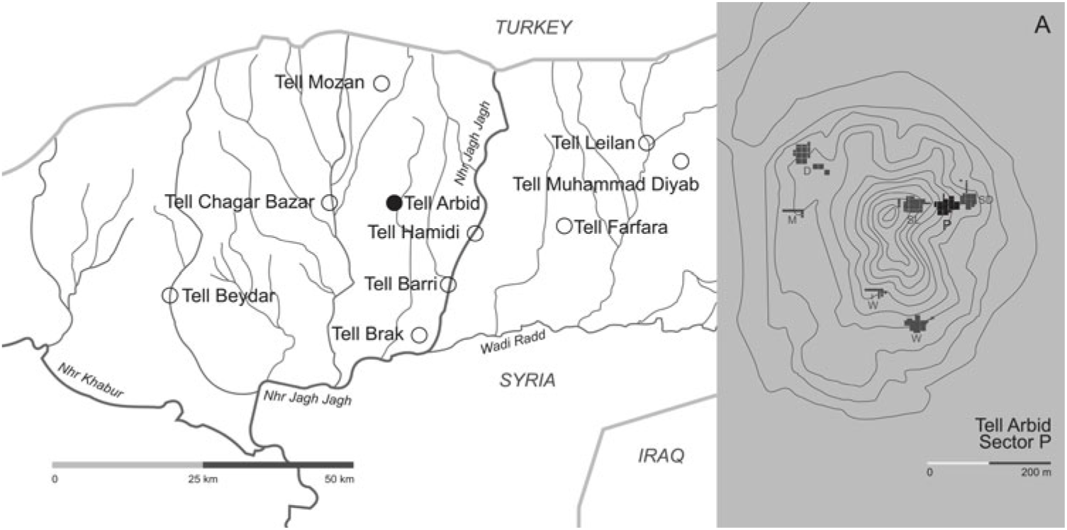
Figure 1 Contour plan of Tell Arbid (A) and map of the Khabur Triangle (a gently undulating fertile plain limited by Khabur river on the west, and Wadi Radd on the east), showing locations of the sites discussed (drawn by Xenia Kolińska).
Table 1 Chronology of the turn of the 3rd millennium BC in Mesopotamia.

a For Low-Middle Chronology, 8 years should be deducted from all figures in this column.
b Absolute dates for the 3rd mill. BC after Sallaberger (Reference Sallaberger and Lebeau2011), for the 2nd mill. BC after Pruzsinszky (Reference Pruzsinszky2009).
c Absolute dates for the 3rd mill. BC after Lebeau (Reference Lebeau and Lebeau2011a), for the 2nd mill. BC after Pfälzner (Reference Pfälzner and Höflmayer2017).
d Depending on alternative length of the Gutian period, either 100 or 60 years (Sallaberger Reference Sallaberger and Lebeau2011:332).
After 2350 BC, southern Mesopotamia had been conquered by Sargon of Agade, founder of the Akkadian dynasty. The conquest of the north, initiated either by Manishtushu or Rimush, the second and third kings of the dynasty respectively, was completed during the reign of Naram-Su’en, resulting in the replacement of indigenous local kingdoms by an imperial Akkadian administration. Its presence is most clearly observable in Tell Brak, where a large structure with military and storage functions was constructed, and where tablets conforming to Akkadian administrative standards were discovered (Eidem et al. Reference Eidem, Finkel, Bonechi, Oates, Oates and McDonald2001). Tablets from the later period of the same administrative tradition were also discovered at Tell Mozan/Urkesh and at Tell Leilan/Shehna (Sallaberger Reference Sallaberger and Lebeau2011).
During the last quarter of the 3rd millennium BC, a further decrease in settlement in northern Mesopotamia can be observed, although scholars differ in opinion as to the extent of this process, its reasons, and its consequences. Weiss et al. (Reference Weiss, Courty, Wetterstrom, Guichard, Senior, Meadow and Curnow1993) proposed that a hiatus in the settlement sequence observed at Tell Leilan after ca. 2200 BC (Weiss et al. Reference Weiss, Courty, Wetterstrom, Guichard, Senior, Meadow and Curnow1993; Weiss Reference Weiss, Bawden and Reycraft2000, Reference Weiss and Weiss2012a, Reference Weiss and Höflmayer2017), was caused by “4.2 ka BP abrupt climate change,” causing a mega-drought lasting for a period of two to three centuries (Weiss Reference Weiss, Bawden and Reycraft2000, Reference Weiss and Weiss2012a, Reference Weiss, Steiner and Killebrew2014, Reference Weiss2016, Reference Weiss and Höflmayer2017). According to this hypothesis, the climate change forced abandonment of nearly all the settlements located both within the Khabur region and to the east, and a considerable reduction in the area of those which remained. Field research carried out in the late 1990s and 2000s demonstrated that a number of sites located in the Khabur Triangle area continued to be occupied (for instance, Tell Arbid, Tell Barri, Tell Chagar Bazar, Tell Hamukar, Tell Mozan, Tell Muhammad Diyab, and some additional sites identified by surveys) during at least part of the period under discussion (Weiss Reference Weiss2012b; Pruss Reference Pruss, Orthmann, al-Maqdissi and Matthiae2013). Only the western part of the Jezirah (the term “Jezirah” refers to the undulating plains of northern Mesopotamia between the Tigris and Euphrates, cf. Lebeau Reference Lebeau and Lebeau2011a), along the Balih valley, seems to have been, in fact, entirely abandoned (Pruss Reference Pruss, Orthmann, al-Maqdissi and Matthiae2013). Therefore, the notion of the “total abandonment of the area” may be brought into question (Koliński Reference Koliński2007a; Kuzucuoğlu and Marro Reference Kuzucuoğlu and Marro2007; Pfälzner Reference Pfälzner2014, Reference Pfälzner and Höflmayer2017).
The tendency towards the abandonment of settlements reached its apex at the beginning of the 2nd millennium BC; only a few sites in northeastern Syria (Tell Barri, Tell Arbid, and possibly also Tell Mozan, Tell Leilan, and Tell Brak, respectively) yielded sequences of strata for this period. Accordingly, even the definition of pottery assemblages typical for period OJZ I was hardly possible until recently (Koliński Reference Koliński and Bonatz2014; Pfälzner Reference Pfälzner and Höflmayer2017). Nevertheless, Old Assyrian trade routes to Anatolia traversing the region would have required settlements as overnight stops on the road, which must have triggered a steady increase in settlement density. The amelioration of environmental conditions and the settling down of the Amorite nomads are responsible for the dynamic increase in sedentism at the beginning of the OJZ II period (Ristvet and Weiss Reference Ristvet, Weiss, Orthmann, al-Maqdissi and Matthiae2013). This period is documented by local archives, discovered either in palatial or administrative buildings at Tell Chagar Bazar/Ashnakkum, Tell Brak/Nagar, Tell Leilan/Shubat-Enlil/Shehna, and Tell Rimah/Qattara. The texts recovered provide clear synchronism with the archives of Kanesh in Anatolia on the basis of eponymal dates (Barjamovic et al. Reference Barjamovic, Hertl and Larsen2012), and to those of Mari, Eshnunna, and the southern Mesopotamian political centers of the Old Babylonian period (Charpin Reference Charpin, Charpin, Edzard and Mesopotamien2004; Veenhof and Eidem Reference Veenhof and Eidem2008).
Absolute Chronology of Bronze Age in Mesopotamia
The absolute chronology of the Mesopotamian Bronze Age for the majority of the period is a matter of discussion. Historical sources such as king lists or royal chronicles cover periods separated by long lacunae, rendering the creation of an absolute historical chronology well-nigh impossible. Through references to astronomical phenomena recorded in ancient texts, several competing chronological schemes more than 150 years apart have been proposed in the past couple decades (Pruzsinszky Reference Pruzsinszky2009). A recently published study of the dendrochronological evidence from 2nd millennium BC Anatolia favors both the so-called Conventional Middle Chronology and the Low-Middle Chronology, younger by 8 years (Manning et al. Reference Manning, Griggs, Lorentzen, Barjamovic, Bronk Ramsey, Kromer and Wild2016; Table 1).
The limited number of texts from 3rd millennium BC northern Mesopotamia (Sallaberger Reference Sallaberger and Lebeau2011) has caused difficulties within the reconstruction of the historical chronology of the area: in light of this situation, scholars have turned to 14C dating as a source of chronological information. For northern Mesopotamia, Ristvet (Reference Ristvet and Lebeau2011) collected 150+ radiocarbon (14C) dates of samples coming from precisely defined, undisturbed archaeological contexts belonging to the 3rd millennium BC. However, within this collection, the initial two centuries and the final two centuries of the millennium were clearly underrepresented (Figure 2; dates are attributed to particular centuries on the basis of median value of the calibrated date).

Figure 2 Numbers of available radiocarbon dating results for the turn of the 3rd millennium BC in northern Mesopotamia (cal. BC, 0σ).
The database for 14C dates from the early 2nd millennium BC remains much more limited. This period is generally viewed as historical due to cuneiform texts discovered at numerous sites in the area. Consequently, most of the archaeologists working on this period did not seem to be interested in the 14C dating of the archaeological contexts. Moreover, until recently, the first two centuries of the millennium were hardly evident from archaeological materials; only a few years ago, settlements of this period were identified at Tell Barri (Baccelli and Manuelli Reference Baccelli, Manuelli, Córdoba, Molist, Pérez, Rubio and Martínez2008), at Tell Mozan (Pfälzner Reference Pfälzner2014, Reference Pfälzner and Höflmayer2017), and at Tell Arbid (Koliński Reference Koliński and Bonatz2014).
Despite the high number of reliable 14C dates, comparison of historical and 14C-based chronologies is difficult, mainly because the contexts yielding the 3rd millennium BC archives have hardly been dated by means of 14C. Moreover, most of the available 14C dates come from northern Mesopotamia, and predate the period of the archives, rendering them useless for such comparison. The number of 14C dates from southern Mesopotamian sites, which yielded rich archives, is even less promising.
Since 2012, when the research described in the present paper was planned, more 14C dates have become available. Most of them refer to the site of Tell Leilan, and stem from the Late Akkadian period (24th–23rd centuries BC; Figure 2). A few more new dates came from Tell Mozan and Tell Brak (dates are quoted in Emberling et al. Reference Emberling, McDonald, Weber, Wright and Weiss2012, but the original study remains unpublished).
A recent study of evidence from Middle Bronze Age Anatolia by Manning et al. (Reference Manning, Griggs, Lorentzen, Barjamovic, Bronk Ramsey, Kromer and Wild2016) offered new data, allowing the precise linkage of dendrochronological data from the sites of Acemhöyük and Kültepe to the 33-year-long period of kingship of Samsi-Addu I, King of Assur. The data presented speak in favor of the Middle Chronology, which is also employed in the present paper, or the Middle-Low Chronology, positioned 8 years later. Due to synchronisms of this king with rulers from Mari, Eshnunna, and Babylon, it is possible to establish precise dates for the Old Babylonian period, and for the preceding period of the 3rd Dynasty of Ur, going back to the turn of XXII century BC. However (see Table 1), absolute dates for the Akkadian period remain uncertain as the length of Gutian period posterior to it may be of either 60 or 100 years in duration, depending on written source (Sallaberger Reference Sallaberger and Lebeau2011).
In this paper, we present a new series of 14C dates from the site of Tell Arbid (Figure 1). These dates, covering the period between the 23rd and 18th centuries BC, considerably enrich (Figure 2) the chronological information on settlement in the region during the transition between the 3rd and 2nd millennia BC.
Tell Arbid
The Site
The site of Tell Arbid (36º52′21″N, 41º01′18″E) is located in the central part of the Khabur Triangle (Figure 1). Numerous minor tributaries of the River Khabur flowing down from springs at the base of Tur Abdin mountains in the north provide water for people and animals, and rainfed agriculture is possible in most of the area due to relatively high levels of mean rainfall (Weiss Reference Weiss and Höflmayer2017).
The archaeological site of Tell Arbid consists of a roughly rectangular tell measuring approximately 400 by 250 m and dubbed the “Lower Town,” with an L-shaped central summit rising to 27 m above the plain termed the “Citadel” (Figure 1a), and three smaller satellite mounds located west of it; the entire archaeological site is approximately 16 ha in area. The site was the object of test excavations by Sir Max Mallowan in May 1936 (Koliński Reference Koliński2007b). Systematic excavations were resumed in 1996 by the Polish-Syrian Archeological Mission, led jointly by Professor Piotr Bieliński of the University of Warsaw and Dr. Ahmad Serriye of the Direction General of Antiquities and Museums (Bieliński Reference Bieliński1997); these continued until the outbreak of civil war in Syria in 2011.
The site turned out to be an important settlement of the EJZ I-II periods (early 3rd millennium BC), when it served as a local center, ca. 10 ha in area. Over the later 3rd millennium, the site area slowly contracted in size to about 4 ha in the EJZ 5 (Post-Akkadian) period. A similar tendency was observed during the 2nd millennium BC, represented by a settlement of the OJZ II period; during the early Late Bronze Age, the main part of the site was abandoned and used only as a graveyard, while houses were built on at least one of three satellite mounds located to the west of the main mound.
The interest in the Early to Old Jezirah transition was triggered by the publications of Weiss et al. (Reference Weiss, Courty, Wetterstrom, Guichard, Senior, Meadow and Curnow1993) and the ensuing discussion (Kuzucuoğlu and Marro Reference Kuzucuoğlu and Marro2007; Pfälzner Reference Pfälzner, Laneri, Pfälzner and Valentini2012, Reference Pfälzner2014, Reference Pfälzner and Höflmayer2017), in which one of the authors of this paper took part (Koliński Reference Koliński2007a), and the fact that Post-Akkadian remains were identified in two different areas on Tell Arbid. Excavations on the “Citadel” (the southeastern part of Sector S) revealed two archaeological strata of Post-Akkadian remains, greatly disturbed by later pit digging (Rutkowski Reference Rutkowski2006). In 2001, some much better-preserved structures were unearthed on the eastern slope of the “Citadel” in a small sounding dug under the Old Jezirah period houses, convincing Koliński to excavate these remains to a greater extent. The fieldwork in the so-called Sector P, undertaken during the years 2008–2010 (Figure 1a), yielded the discovery of substantial deposits from the Post-Akkadian age encapsulated between the Akkadian and the OJZ II architectural levels (Koliński Reference Koliński and Weiss2012).
Archaeological Context: Sector P
Eight stratigraphic units were identified within the trenches of Sector P, the three earliest of which (VIII, VII, VI) were only marginally excavated (Koliński Reference Koliński and Weiss2012). The Post-Akkadian period remains directly overlying the Late Akkadian Strata VII and VI in most of the area in question were represented by two levels. In Stratum Vc, a large (approx. 14 × 14 m) structure unearthed (Figure 3a) was interpreted as a caravanserai located on the road from Tell Brak/Nagar (and the Middle Euphrates valley to the south) to Tell Mozan/Urkesh (and the Ergani Maden copper mines to the north). After two phases of use (Vc-b), the caravanserai was abandoned; however, some structures were being used in the western part of the area (Stratum Va), and the presence of pits and graves with Post-Akkadian pottery cutting into remains of the Caravanserai (Stratum IV) indicate continuous settlement at the site. After a break of an undetermined length, the area was resettled in the OJZ I period; pits containing ashes and the remains of pottery kilns yielding Early Khabur Ware pottery (Stratum III) (Koliński Reference Koliński and Bonatz2014) demonstrate the presence of some manner of population at the site already in the later part of the OJ I period (Figure 3b). Towards the end of OJZ I, a house (House III) was erected in the eastern part of the area. Later on, three artificial terraces were constructed on the “Citadel” slope towards the west, upon which five more houses were raised, accompanied by cemeteries (Figure 3c). Finally, in some places, the very eroded remains of yet later settlement were identified just under the present surface of the ground (Stratum I).

Figure 3 (a) Tell Arbid, Sector P: Post-Akkadian (EJZ 4c-5) remains of stratum V with the location of the analyzed samples indicated (drawn by Xenia Kolińska). (b) Tell Arbid, Sector P: Old Jezirah I period remains of stratum III with the location of the analyzed samples indicated (drawn by Xenia Kolińska). (c) Tell Arbid, Sector P: Old Jezirah II period remains of stratum II with the location of the analyzed samples indicated (drawn by Xenia Kolińska).
The general stratigraphic situation of the area is, however, much more complicated than is suggested above. This is because of the significant terracing of the slope, conducted at least twice during the latter part of the 3rd millennium BC (prior to erecting the Akkadian and Post-Akkadian structures), and once in the early phase of the Old Jezirah period. As a result, recorded levels and preserved wall sections could not be dated on the basis of their elevation a.s.l. (for instance, early 3rd millennium levels in the western part of the sector were encountered just under the surface of the tell, and ca. 2.5 m above the Post-Akkadian floors in the central part of the area, both structures being situated only 20 m apart). The Post-Akkadian remains also suffered from later activities: pit and grave digging from Stratum IV, large refuse pits from Stratum III, and, most importantly, from the foundations of the OJZ II period houses, reaching some 1.5 m deep into the soil, and cutting through the floors and walls of the earlier structures, and from their associated graves (Figure 3c).
Disruptions in the continuity of the archaeological strata described above, visible in most of the recorded sections, caused some problems in interpreting the internal relationships between the unearthed structures. For the eastern and central parts of Sector P, the most important building is the Caravanserai or Main Building (as it was referred to in the interim reports), constructed in Phase Vc and modified in Phase Vb (Figure 3a). The end of Phase Vb is marked by an abandonment of the Caravanserai (it seems that the wooden beams roofing the central room had been removed away, causing a layer of clay, originally forming the roof, to build up on the floor of this room). Another structure, dubbed Extension 1, seems to be contemporary with the caravanserai, as is evident from the similarity in the quality of construction technique and the mudbricks used; it also displays two phases of use. Further to the west, a sequence of three architectural strata was discovered, featuring a foundry furnished with a foundry kiln (Extension 2) in the intermediate and upper strata. Nevertheless, the exact relationship between these three strata and the Caravanserai is far from obvious. In the northern area, a small part of another structure (Extension 3) separated from the Caravanserai by a narrow street was unearthed. Here too, evidence of two subsequent architectural strata was retrieved from this area. Finally, a large open area was discovered south of the complex, featuring some installations, such as a threshing floor and another foundry-type kiln, together with a sequence of floors of tamped earth. This area also yielded graves; most of these seem to have been cut into the usage levels and into the walls of Vc-b structures, which suggests a later date (Stratum Va or even IV). The last structure of this period discovered, a pottery kiln in south-western part of the area, could not be stratigraphically related to any of the phases described. In this situation, the relationship between the Post-Akkadian structures and the strata unearthed in various sections of the Sector P, proposed already in earlier publications (Koliński Reference Koliński and Weiss2012; Wasylikowa and Koliński Reference Wasylikowa and Koliński2014) was unclear and was hence tested using 14C dating.
No structural remains were identified within Stratum IV; activities in the sector consisted of pit-digging and burials piercing the aforementioned structures. The settlement contemporary to this stratum was probably restricted to the uppermost part of the site. The proposed chronology of this level is based mainly on the fact that the pits cut the walls and floors of Stratum V, and some of them are in turn cut by deep foundation trenches of Stratum II. The pits contained exclusively scarce Post-Akkadian material, either residual within the earth used to fill them, or coming from the eroding walls of the pits. Stratum IV and Stratum III are separated by a hiatus of unknown length. The archaeological data (difference in material culture between both strata) speaks in favor of 100 years or more of abandonment.
Stratum III (Figure 3b) consists of several dispersed structures: two pottery kilns, a fragmentary wall, a bread-oven, and some surfaces stabilized by pottery sherds, as well as at least two large pits with ashy fill, cutting again into the Post-Akkadian remains. In the northwestern part of the area, kilns were accompanied by alternating layers of clay and ash either resulting from the usage of the pottery kilns or washed down from ashy deposits of similar age identified on the top of the “Citadel” mound. The contexts listed contained some Post-Akkadian pottery, clearly residual, as well as a particular type of painted ware constituting an archaic variant of Khabur Ware, common to the OJZ II-III period (Koliński Reference Koliński and Bonatz2014). Neither the sequence of the objects identified as belonging to Stratum III nor the length of this phase could presently be established.
Stratum II (Figure 3c) documents a resettling of the area. The slope was shaped into three terraces, upon which several houses were built. House III, constructed on the lowest terrace, is by far the oldest, the second in antiquity being the neighboring House I erected on the medium terrace, most likely then followed by the construction of House II. The houses were accompanied by small cemeteries used for deceased family members; in some cases, it was possible to reconstruct the relationship between cemeteries and houses. This level was probably long in duration: the original phase of House III was attributed to Stratum IIc, the construction phases of Houses I and II and the later phase of House III to Stratum IIb, and the later phases and extensions of Houses I and II to Level IIa. Only the foundation trenches were discovered of Houses IV and V; thus, it proved impossible to determine as to which stratum they belonged. The houses were accompanied by cemeteries located in open areas; altogether 35 chamber and shaft graves were documented.
Archaeobiological Context
Palaeobotanical samples from Tell Arbid were retrieved either by means of dry sieving (throughout all seasons) or by flotation (during the 2010 season). In some cases, one sample of carbonized deposit was divided into two parts, one of which was sieved and the other of which was floated, to establish the relative efficiency of the retrieval of charred remains between both methods (Wasylikowa and Koliński Reference Wasylikowa and Koliński2014:282).
According to palaeobotanical studies, all analyzed assemblages contained grains, threshing byproducts, and weeds, suggesting that they resulted either from the burning of threshing remains, or animal dung (Wasylikowa and Koliński Reference Wasylikowa and Koliński2014:288). Ashes formed mostly secondary deposits, accumulated either in pits, or against existing walls, or on the floors of structures. Finally, some deposits were retrieved from the fill of graves, from the clay of which mudbricks used for structures or pisé walls/foundations were formed.
Three samples of charred wheat were sent in 2011 to the 14C laboratory of the University of Arizona and dated within the framework of Harvey Weiss’ project (Koliński Reference Koliński and Weiss2012). The successful dating of these three samples encouraged the present authors to date the remainder of the samples, and to reconstruct the absolute chronology of the settlement in a comprehensive manner.
METHODOLOGY AND RESULTS OF 14C DATING
Samples and Their Analyses
Samples for 14C dating were collected from 29 contexts in the deposits of the Late Akkadian Stratum VI (1 context), earlier Post-Akkadian Stratum V (15 contexts), of the Early Khabur Ware Stratum III (6), and of the Classical Khabur Ware Stratum II (8). The description of the contexts is given in the supplementary information (SI), Table S1. Crop grains were exclusively chosen for dating, mostly those identified as barley (Hordeum sp.), wheat (Triticum sp., 3 samples), or more generally as Cerealia (6 samples; SI, Table S1).
14C dating was performed using the accelerator mass spectrometry (AMS) technique at the Poznań Radiocarbon Laboratory (Goslar et al. Reference Goslar, Czernik and Goslar2004). From each context, two single grains (or grain fragments) were dated as separate samples labelled Arbid Pxx and Arbid Pxx BIS. The details of laboratory processing are given in the SI. The combined 14C ages (SI, Table S2) were calibrated using the OxCal 4.2.3 (Bronk Ramsey Reference Bronk Ramsey2009; Bronk Ramsey and Lee Reference Bronk Ramsey and Lee2013) against the calibration curve IntCal13 (Reimer et al. Reference Reimer, Bard, Bayliss, Beck, Blackwell, Bronk Ramsey, Buck, Cheng, Edwards, Friedrich, Grootes, Guilderson, Haflidason, Hajdas, Hattè, Heaton, Hoffmann, Hogg, Hughen, Kaiser, Kromer, Manning, Niu, Reimer, Richards, Scott, Southon, Staff, Turney and van der Plicht2013). Calibrated dates of all samples are presented in Figure 4.

Figure 4 Calibrated 14C dates of samples representing cultural strata VI through II in Tell Arbid, sector P. The bars below probability distributions of calibrated dates represent 2-sigma confidence intervals.
Grain samples from three contexts (P06, P40, P12) were also dated earlier in Arizona (Koliński Reference Koliński and Weiss2012:125; dates marked in Figure 4 as Arbid Pxx Arizona). However, for P06, poor agreement between the Arizona and Poznań dates was noted. In this situation, suspecting exchange of samples P06 and P12 in the Poznań laboratory, we took additional pairs of grains from the original archaeobotanical collection, and obtained additional pairs of dates, quoted as Arbid PxxS and Arbid PxxS BIS, respectively. The additional dates fully agreed with the Poznań results originally obtained on these samples (Figure 4).
Analysis of the Dating Results
The dates obtained were analyzed by Bayesian modeling using OxCal v. 4.2.3, (Bronk Ramsey and Lee Reference Bronk Ramsey and Lee2013). In the model, the dates were grouped into six phases, corresponding to Stratum VI (Context P09), Stratum Vc (Contexts P06, P23, P40), Vb (P08, P10, P19, P25), Va (P01, P05, P12), III (P02, P03, P07, P11, P13, P20, P22, P24, P39), IIc (P04, P21, P26), and IIb-a (P14, P18, P27, P28, P29, P42). However, sequencing the 14C dating results according to the order of strata (Figure 4) indicated severe inconsistencies in many 14C dates from Strata III and II. These inconsistencies precluded Bayesian modeling of the whole set of dates and forced us to reconsider samples from as many as nine contexts (P20, P22, P26, P18, P29, P02, P13, P28, and P14) as not representative for the true age of the strata. The details of this reconsideration are given in the Supplementary Information section. Here, we can only remark that almost all rejected materials were retrieved from the fill of graves, or from clay from which mudbricks used for structures or pisé walls/foundations were formed, i.e. from contexts where mixing of material from older periods was more probable.
A Bayesian model with the 9 contexts rejected (Figure 5 and SI) provided a good agreement index (Amodel: 104), with only 2 (of 57) individual dates of agreement below 60 (P06 Arizona – A: 50, P07 – A: 38). Therefore, we believe that the model presented delivers both the most reliable and accurate chronological information which can be derived from the material dated in this work.

Figure 5 Consistent Bayesian model of 14C dates from Tell Arbid, Sector P.
The sequence of phases (Figure 5) models two periods of occupation of the eastern part of Tell Arbid at the turn of the 3rd millennium BC, with a short gap between Strata V and III. In consequence, Tell Arbid, with its clear sequence of levels and rich series of consistent 14C dates, would become the main reference point for the terminal 3rd and early 2nd millennium period within the Khabur Triangle.
DISCUSSION
Processing grain samples retrieved from 29 contexts at Tell Arbid have nearly doubled the number of 14C dates available for the turn of the 3rd millennium BC in northern Mesopotamia and constituted a significant step towards a reliable 14C chronology for the period in question. After exclusion of outlier dates of samples most likely containing residual organic material, Bayesian modeling provided a set of dates for Strata V, III, and II of the site, corresponding to the Post-Akkadian, Old Jezirah I, and Old Jezirah II periods. Unfortunately, no date pertains to Stratum IV, and thus there is no direct way to determine the length of this period, and the length of abandonment phase between Strata V and III.
At this level of analysis, it is important to compare the Tell Arbid 14C chronology with the neighboring 14C-dated sites, namely Tell Leilan, Tell Brak, and Tell Mozan (Table 2). It must be stressed that none of these sites seems to have a continuous sequence of strata throughout the turn of the 3rd millennium BC. At Tell Leilan, there is a long hiatus between Level IIc (Early Post-Akkadian) and Early Level I (Early Khabur Ware); at Tell Brak, no Early Khabur Ware (OJZ I) stratum has as of yet been identified, while Tell Mozan, despite Pfälzner’s claim (Reference Pfälzner and Höflmayer2017), seems to feature a hiatus as well, as is suggested by 14C dates (cf. below and Table 2).
Table 2 Proposed radiocarbon chronology for the Post-Akkadian to Old Babylonian transition in the central Jezirah. Isolated dates in italic, doubtful ones in brackets.

Tell Leilan
Tell Leilan yielded a long sequence of 14C dates, especially for Periods IIId, IIa, and IIb, corresponding to Late EJZ 3, Akkadian/EJZ 4a and Late Akkadian/EJZ 4b, respectively, but only a very limited number of dates relevant for Periods IIc (Post-Akkadian/EJZ 4c) and I (Khabur Ware/OJZ), respectively (Ristvet Reference Ristvet and Lebeau2011). The set of dates presented by Ristvet was considerably extended in a later publication of Weiss et al. (Reference Weiss, Manning, Ristvet, Mori, Besonen, McCarthy, Quenet, Smith, Bahrani and Weiss2012), focusing specifically on the Akkadian and Post-Akkadian period at Leilan. At present, 14C chronology of the terminal 3rd millennium BC at Tell Leilan is based on 93 high-resolution dates covering Periods IIb, IIc, and Early I (Table 2). Again, the most densely sampled is Period IIb at Acropolis NW sector, dating to the Late Akkadian period. The short-lived Post-Akkadian Period IIc is represented by 12 dates, and the Early Period I (OJZ I) by four dates only. According to this set of dates, the Late Akkadian period at Leilan falls within a period of 2348–2220 BC (this, and the subsequent dates represent 2σ intervals of calibrated dates), the ephemeral Post-Akkadian house to a period of 2254–2204 BC, and the Early Khabur House to a period of 1964–1889 BC (Weiss et al. Reference Weiss, Manning, Ristvet, Mori, Besonen, McCarthy, Quenet, Smith, Bahrani and Weiss2012).
The abundance of high-resolution dates at Tell Leilan generally provides a sound base for the 14C chronology because of the precise dating of the Late Akkadian remains. This record could be used as a very good starting point for the reconstruction of the chronology of the following centuries. The evidence for the Post-Akkadian and Early Khabur settlement on the Acropolis NW, however scarce, is in agreement with Tell Arbid dates.
Tell Brak
Earlier excavations carried out at Tell Brak yielded 37 14C dates, some with a wide probability margin, falling mostly within the early or mid 3rd millennium BC (Ambers Reference Ambers, Oates, Oates and McDonald2001; Ristvet Reference Ristvet and Lebeau2011). Bayesian modeling of seven dates relevant to the terminal 3rd millennium situated Period M (corresponding to EJZ 4a-b according to excavators) at 2308–2162 BC, and Period N (EJZ 4c-5) at 2157–1896 BC, i.e. later than expected from the other studies (Ristvet Reference Ristvet and Lebeau2011). Thus, dates of both these periods were not included in Table 2.
More recent research within Area TC yielded another series of samples dating to the terminal centuries of the 3rd millennium. For the present study, relevant are the dates of the samples retrieved from the so-called Pisé Building, whose earlier floor is dated to 2460–2200 BC, and the later floor to 2290–2140 and 2290–2060 BC (Emberling et al. Reference Emberling, McDonald, Weber, Wright and Weiss2012). The finds from the later floor, typical of the EJZ 4c-5 period both in Brak and in Arbid corroborate the 14C dates for this context quoted (Emberling et al. Reference Emberling, McDonald, Weber, Wright and Weiss2012; Koliński Reference Koliński and Weiss2012).
Tell Mozan
Cultural Phases C07, C06, and C05, excavated in the central area of Tell Mozan and representing the transition from the Early to Middle Bronze Age period, yielded four, two, and three 14C dates, respectively (Pfälzner Reference Pfälzner2014, Reference Pfälzner and Höflmayer2017).
Of the four dates of the samples retrieved from the contexts belonging to Phase C07 (Post-Akkadian), one falls in the range of EJZ 3-4 (2459–2295 BC). The remaining three are more or less contemporary with the EJZ 4c-5 period at other sites (2271–2061, 2140–2033, and 2191–2036 BC). One of the two dates from Phase C06 (attributed to OJZ I) falls within the range of three EJZ 4c-5 dates from Phase C07 (2199–2039 BC), suggesting either a very short time interval between these strata, or the presence of residual material in the C06 levels. The other date from C06 (2403–2205 BC) definitely originates from residual material, so, at this stage, we consider the 14C age of Phase C06 to be poorly determined. Three dates from Phase C05 are also widely dispersed (Felix Höflmeyer, personal communication). One of them is the oldest among the Mozan dates falling within EJZ 3a (2568–2462 BC). The other falls within the range of earlier dates of EJZ 4c dates for Strata C07 and C06 (2339–2151 BC), and only one date belongs, as it may be expected, to the 2nd millennium BC (1872–1686 BC). Consequently, the Mozan dates have not been subjected to Bayesian modeling and are listed in Table 2 individually.
CONCLUSION
The Arbid chronological sequence, linked to a precisely recorded archaeological stratification, shows a high level of agreement with the published late 3rd millennium dates from Tell Brak and Tell Leilan, and also it partly fills the chronological gaps caused by the apparent abandonment of both sites at the turn of the 3rd millennium BC (Table 2).
More specifically, the dates from Tell Arbid place the onset of EJZ 4c before 2240 BC; this is earlier than suggested by Middle Chronology (Table 1), but is, however, in agreement with indications from the studies from Tell Leilan (cf. Boundary end IIb1 in Table 2). Three phases of Post-Akkadian settlement in Sector P are dated to 2311–2206, 2231–2145, and 2174–2051 BC, respectively; the first two feature the use of the Caravanserai, constructed and used continuously during the EJZ 4c; the third one corresponds to activities at the site after the abandonment of this structure, extending into the EJZ 5 period. The Boundary up for Stratum V (Table 2) is modeled at 2126–2025 BC. These dates demonstrate that Stratum V at Tell Arbid may have endured as much as 100 years after the abandonment of the Post-Akkadian ephemeral settlement at Tell Leilan (Period IIc). On the other hand, dates modeled for Tell Arbid are in agreement with 14C dates for the later phase of the Pisé Building at Tell Brak; this parallel is corroborated by similarities in archaeological materials retrieved in the aforementioned contexts at Arbid and Brak. The 14C dates from Mozan, due to inconsistencies, are more difficult to include. However, three dates for Pushsham’s House (dated to EJZ 5 period on the grounds of seal impressions) fall within range of the Tell Arbid Stratum V dates, especially with respect to Stratum Va. It is unfortunate that no Arbid sample dates to the Arbid IV period. Consequently, there is a gap in the 14C chronology sequence at the site of poorly determined length (20–230 years). The chronology of the early 2nd millennium BC is less satisfactory, mainly because of the relatively high number of outlier dates. Notwithstanding this result, the modeled date for Stratum III (1974–1880 BC) is in good agreement with the Early Khabur dates from Leilan (1964–1889 BC), and with the Middle Chronology date for the beginning of the OJZ II period at Tell Mozan (Tables 1 and 2). The Boundary up for Strata III-II is set at 1889–1761 BC, suggesting that the settlement of this phase was abandoned towards the end of 19th century BC, or slightly later, at the time of the conquest of northern Mesopotamia by Samsi-Addu I (whose reign is now at placed at 1810–1776 or 1802–1768 BC, cf. Manning et al. Reference Manning, Griggs, Lorentzen, Barjamovic, Bronk Ramsey, Kromer and Wild2016).
The Arbid results corroborate the Middle (or Middle-Low) Chronology suggested by Manning et al. (Reference Manning, Griggs, Lorentzen, Barjamovic, Bronk Ramsey, Kromer and Wild2016) for the early centuries of the 2nd millennium BC, which, on the basis of Mesopotamian historical sources, could be extended over the 21st century BC. However, the EJZ 4c dates from Arbid and other discussed sites tend to fall in the range of the Late Akkadian dates proposed by the Middle Chronology. In our opinion, this result speaks in favor of accepting a figure of 100 years for the length of the Gutian period over one of 60 years (cf. Table 1), but the subject is open to further discussion.
The 14C chronology presented here is in need of further improvement. The most important step to be undertaken is the relating of the high-resolution 14C dates and historical evidence by means of the 14C dating of contexts yielding datable written sources from northern Mesopotamia. We expect such dates would probably confirm the chronology proposed by Manning et al. (Reference Manning, Griggs, Lorentzen, Barjamovic, Bronk Ramsey, Kromer and Wild2016) and put an end to the decades-long dilemma of the several conventional chronologies employed for Mesopotamia in the 3rd and early 2nd millennium BC. For the time being, none of the sites on which cuneiform archives of the early 2nd millennium BC were discovered (Tell Hariri/Mari, Tell Bi’a/Tuttul, Tell Chagar Bazar/Ashnakkum, Tell Rimah/Qattara, and Tell Leilan/Shubat-Enlil/Shehna) provided such dates, probably because of a lack of suitable samples. The civil war in Syria renders it highly unlikely that new samples might be retrieved soon in order to address this shortage.
SUPPLEMENTARY MATERIAL
To view supplementary material for this article, please visit https://doi.org/10.1017/RDC.2019.49
ACKNOWLEDGMENTS
The present study was possible due to the research project no. 2013/09/B/HS3/00628 “Radiocarbon dating of the turn of the 3rd millennium BC in Northern Mesopotamia” awarded to the authors by the National Science Centre, Republic of Poland in 2013.
The authors would like to thank three anonymous reviewers for their helpful insights that considerably improved this paper.
Special thanks are due to Professor Krystyna Wasylikowa, who studied plant remains from the site, to Professor Harvey Weiss of Harvard University for including within his 14C project three samples from Tell Arbid dated at Arizona University in 2011, and to Dr. A. J. T. Jull and staff at the Arizona AMS Laboratory who undertook these analyses. The authors are also extremely grateful to Dr. Felix Höflmeyer for providing specific information on the Mozan Stratum C05 dates prior to their publication, to Professor Önhan Tunca (University of Leuven) and Dr. Christophe Nicolle (College de France) for information on unpublished 14C dates from Tell Chagar Bazar and Tell Muhammad Diyab respectively, and last but not least, to Alexander Johannes Edmonds for correcting the language of this text.


