INTRODUCTION: PROJECT BACKGROUND
In this paper we present new radiocarbon (14C) dates from Neolithic mines and quarries in Britain. These have been generated through the collaborative research efforts of the authors, and primarily funded by the Leverhulme Trust as part of the project “Supply and demand in prehistory? Economics of Neolithic mining in NW Europe”. This project aimed to address the question of what economic factors, if any, influenced the scale of mining and quarrying in the Neolithic. There is no doubt that many of these sites were large and there was a huge quantity of raw material extracted, however chronological sensitivity has been very weak until now. Obtaining a reliable measure of the period of use of individual mines and quarries is critical to determining whether particular extraction sites were exploited contemporaneously or consecutively, which can then allow for further inferences to be made relating to factors that potentially affected extraction activity, such as demand generated by local or regional population levels (Schauer et al. Reference Schauer, Shennan, Bevan, Cook, Edinborough, Fyfe, Kerig and Pearson2019).
In this paper we present some surprisingly consistent results based on a collation of all existing dates and a program of systematic re-dating of excavated mines and quarries in Great Britain. This addresses two key questions. First, is there any dating evidence that mining began in the late Mesolithic, before the arrival of farming? Secondly, are there systematic patterns in the dates of flint-mining and stone quarrying in Britain or are the dates randomly distributed in time through the Neolithic? This has a bearing on whether all mines were producing at the same time, perhaps because they were all responding to a period of high regional demand; or whether they went in and out of use successively, perhaps because new sources were discovered and/or working conditions at existing mines became increasingly difficult. Thus our primary question is when did extraction begin at these different sites, and how long did it last?
Flint mining was a widespread European prehistoric phenomenon demonstrated from archaeological excavations at mining sites from Britain to Poland and Sweden to southern Italy. The mines are located predominantly on primary flint-bearing geology where the flint is laid down as horizontal seams within the chalk or limestone bedrock, in tabular or nodular form (Weisgerber Reference Weisgerber, de Sieveking and Newcomer1987). These mines exhibit a method of extracting flint by either quarrying or using a system of vertical and horizontal shafts. In general terms chronologies for flint mining have been broad, with a reliance on historic radiocarbon dates. The start of the main phases of mining in northern Europe had been estimated at ca. 4500–4200 cal BC (Whittle et al. Reference Whittle, Healy and Bayliss2011: 257–262) although mines in Italy and Spain date back to the 6th millennium BC (Díaz-del-Río et al. Reference Díaz-del-Rí, Consuegra, Capdevila, Capote, Casas, Castañeda, Criado, Nieto and Anreiter2010; Tarantini et al. Reference Tarantini, Galiberti, Mazzaocchi, Capote, Consuegra, Diaz-del-Rio and Terradas2011: 257). It has long been conjectured that the flint extracted from mines was used to manufacture axes for forest clearance during the primary phase of land cultivation, a view which seems to be increasingly supported through new dates on the beginnings of agriculture (e.g. for Scandinavia, Sørensen and Karg Reference Sørensen and Karg2014).
In Britain, as elsewhere, the radiometric dating of mines and quarries has been uneven. Until these projects commenced, there were only a total of 20 radiocarbon dates for seven of the early Neolithic mining sites in southern Britain, that indicated mining activity from possibly as early as 4500 cal BC at Cissbury, Sussex, to as late as 2700 cal BC at Easton Down, Wiltshire (Holgate Reference Holgate1991: 39–40, Reference Holgate1995: 141–150; Barber et al. Reference Barber, Field and Topping1999: 81–82; Russell Reference Russell2000: 55–56). Bayesian modeling of these dates for the start of mining activity were suggested for Cissbury to be 4600–3705 cal BC and Harrow Hill 4250–3705 cal BC (Whittle et al. Reference Whittle, Healy and Bayliss2011, 256) and so extremely early in the Neolithic sequence of southern England. Over half (four of the seven) of the flint mining sites were represented by single radiocarbon determinations and there were additionally concerns regarding the quality of some of the earlier samples (Barber et al. Reference Barber, Field and Topping1999: 68–69; Russell Reference Russell2000: 55–56). Thus, redating these sites has great potential to provide new data on the spread of Neolithic technologies from the continent (Baczkowski Reference Baczkowski2014), and to address the project’s questions. In contrast, the Late Neolithic site of Grime’s Graves has been extensively studied, repeatedly excavated and subjected to detailed analyses. A recently-completed program of re-dating artifacts has produced 305 radiocarbon determinations (256 individual contexts) for the mining phases and subsequent Bronze Age activity at Grime’s Graves (Healy et al. Reference Healy, Marshall, Bayliss, Cook, Ramsey, van der Plicht and Dunbar2018, Reference Healy, Marshall, Bayliss, Cook, Ramsey, van der Plicht and Dunbar2014:16). This has resulted in a detailed understanding of the chronology of the site and has narrowed the estimated duration of mining activity at Grimes Graves to 2665 cal BC to 2360 cal BC (Healy et al. Reference Healy, Marshall, Bayliss, Cook, Ramsey, van der Plicht and Dunbar2014: 55).
Dateable organics from chalk mining sites excavated in the last century and a half are ubiquitous, however the accompanying archives or early curation of materials are not always robust enough to identify individual samples to the level of individual stratigraphic context. Where organic, dateable samples relating directly to mining activities are well-preserved, for instance antler picks left or deposited in situ at the work face (e.g., Holgate Reference Holgate1995: 154–155; Barber et al. Reference Barber, Field and Topping1999: 66–67; Russell Reference Russell2000: 84–92; Healy et al. Reference Healy, Marshall, Bayliss, Cook, Ramsey, van der Plicht and Dunbar2014; Berggren 2016), collagen yields for dating can often be too low for radiocarbon laboratories to measure despite many pre-treatment advances over the last decades. For quarrying sites, organic materials are rare, and are often poorly preserved. There are a small number of human remains in the British mines (Barber et al. Reference Barber, Field and Topping1999: 62–63; Russell Reference Russell2000: 128–132) but they may represent later intrusions into the original depositional sequence, like the Iron Age burials in the 1971 Pit at Grime’s Graves (Healy et al. Reference Healy, Marshall, Bayliss, Cook, Ramsey, van der Plicht and Dunbar2014: 63). In short, precision radiocarbon dating of lithic extraction horizons requires robust archives, is expensive and can be unsuccessful.
Quarrying sites have also only received scant attention in establishing chronologies. Although more quarry sites have been identified and excavated over the past 30 years, it has been common for only a few dates to be generated from excavated material, largely due to post-excavation costs. Combining research efforts has allowed more dates to be generated in this project to gain a better understanding of the chronology of extraction.
Finally, extraction sites often contain mixed deposits from repeated use in the prehistoric or historic periods that may be unrelated to mining activities, which are therefore intrinsically challenging to sequence accurately. Furthermore, underground mining tunnels connect and may have been accessed at a temporally later time than the accompanying vertical shaft. Thus, it is very difficult to achieve fine grained chronological resolution within sites (Healy et al. Reference Healy, Marshall, Bayliss, Cook, Ramsey, van der Plicht and Dunbar2014), as the stratigraphy is confined to individual discrete pits that rarely overlap. We have negated this issue somewhat by dating shaft fills that do provide stratigraphic information, though this therefore restricts the ability for inter-site comparisons without further dating work. Half the new dated samples were identified by one of the authors (AT) during her doctoral and postdoctoral research; nine of these were dated as part of the NEOMINE project and the remaining ten by the NERC-AHRC National Radiocarbon Facility as part of another project (see Teather in press).
MATERIALS AND METHODS
Samples
New samples from the following areas and sites were dated (for full details see SI in the supplementary materials).
1. Great Langdale Quarries (see map: Figure 1)

Figure 1 (Left panel) Schematic reference map of sites in Great Britain and Ireland mentioned in text. 1) Great Langdale; 2) Black Patch Hill; 3) Church Hill; 4) Cissbury; 5) Long Down; 6) New Barn Down; 7) Harrow Hill; 8) Martin’s Clump; 9) Easton Down; 10) Grime’s Graves; 11) Mynydd Rhiw East; 12) Graig Lwyd; 13) Lambay Island; 14) Tievebulliagh. Base map photo by “Unknown Author” is licensed under CC BY-NC. For a detailed map of site locations and other mines and quarries, see Bradley and Edmonds (Reference Bradley and Edmonds1993) and Neomine project website http://www.ucl.ac.uk/neomine/maps. (Right panel) Broken wooden haft with Neolithic axfrom Cumbria, Ehenside Tarn near Whitehaven; POA.190.6. AN753777001 image released by British Museum under a Creative Commons Attribution-NonCommercial-ShareAlike 4.0 International (CC BY-NC-SA 4.0) license.
The Great Langdale lithic production complex covers an area of 500 sq km, with a 7–20-km-wide span, exploiting a horseshoe-shaped igneous greenstone band of epidotised tuff. Fieldwork has revealed 35 groups of 566 distinct working sites (Claris et al. Reference Claris, Quartermaine and Woolley1989), with the main concentration at Harrison Stickle. Approximately 30% of all non-flint stone axes identified and found deposited across Great Britain are sourced to this area (i.e. Group VI, Clough and Cummins Reference Clough and Cummins1988).
Until now, secure radiocarbon dates have been rare (see below and supplementary information). Excavations by Bradley and Edmonds (Reference Bradley and Edmonds1993) produced a number of radiocarbon dates and their assessment of variability within and between the assemblages of Great Langdale led to the conclusion that there were two main phases of exploitation, primarily in the Later Neolithic (Bradley and Edmonds Reference Bradley and Edmonds1993: 105). A further fourteen undated charcoal samples obtained during this fieldwork were kindly provided to the NEOMINE team by Prof. Richard Bradley and examined by Phil Austin in 2017, in order to determine the best short-lived species samples that would provide a secure association between anthropogenic depositional activity and the sample in question. As a result of this analysis, nine samples were selected for dating.
2. South Downs and Wessex Flint Mines
Flint mines have been subject to episodic excavation to varying extents since the nineteenth century (Holgate Reference Holgate1995: 136–150; Barber et al. Reference Barber, Field and Topping1999: 4–14; Russell Reference Russell2000: 12–34). There are two main geographic clusters of early Neolithic mine sites: South Downs and Wessex.
Located on the southern coast of England, near the West Sussex towns of Worthing and Chichester, is an extensive group of prehistoric excavation pits termed the South Downs flint mine group. The entire group consists of Blackpatch, Church Hill, Cissbury, Harrow Hill, Long Down and Stoke Down. New samples for dating were obtained from Blackpatch, Church Hill, Cissbury, Long Down, and New Barn Down.
Northwest of the South Downs Group, on the Hampshire Wiltshire border, the Wessex flint mine group consists of Martin’s Clump, Durrington, and the site of Easton Down. New samples could be obtained from Easton Down only. See Figure 2 for an example of mine shaft stratigraphy.
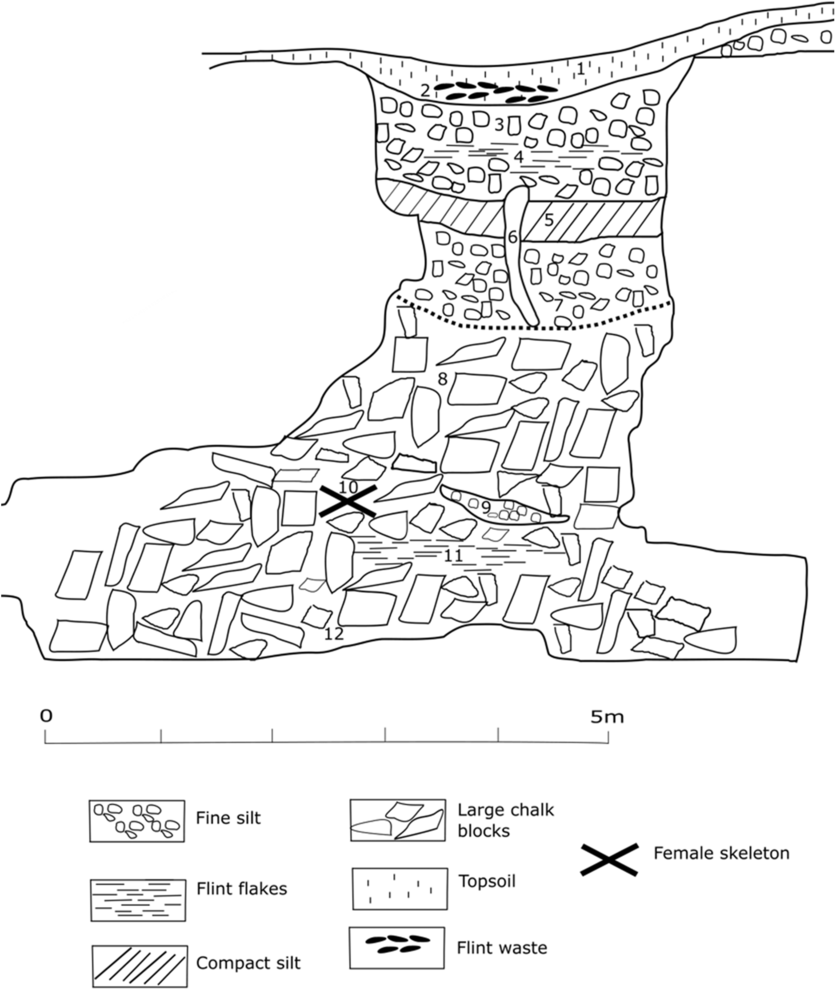
Figure 2 Cissbury Shaft 27 section (after Pull in Russell Reference Russell2001b: 179). Stratigraphic layers interpreted by Anne Teather and relate to dated deposits in Table 1.
Sample Pretreatments and Processing
The samples were processed and measured in collaboration with the Scottish Universities Environmental Research Centre (SUERC) Radiocarbon Dating Laboratory at East Kilbride, Glasgow. All methods including sample pretreatment, CO2 generation and purification, graphitization, and accelerator mass spectrometry (AMS) measurement were as described in Dunbar et al. (Reference Dunbar, Cook, Naysmith, Tripney and Xu2016).
Radiocarbon Calibration Methods
Two different calibration-modeling methods were used to assess the new dates for each site, CalPal (Weninger Reference Weninger1986; Weninger et al. Reference Weninger, Clare, Jöris, Jung and Edinborough2015) and OxCal (Ramsey 1997, Reference Ramsey2009).
CalPal
CalPal software uses 2-D Dispersion Calibration, a method of calibration and graphic display of a series of calibrated dates in which all quantifiable errors (dates and calibration) can be included without any assumptions about bounded archaeological units or the depositional process (Weninger Reference Weninger1986; Weninger et al. Reference Weninger, Clare, Jöris, Jung and Edinborough2015). CalPal can be used to create bespoke calibration curves, although here we choose to use the industry standard IntCal13 (Reimer et al. Reference Reimer, Bard, Bayliss, Beck, Blackwell, Ramsey, Buck, Cheng, Edwards, Friedrich and Grootes2013). Using a combination of Ottaway’s dispersion diagram (Ottaway Reference Ottaway1973) and Geyh’s histogram (e.g., Geyh and de Maret Reference Geyh and Maret1982) methods to display calibrated results, CalPal software calculates a calibrated probabilistic histogram that integrates to one on the x-axis in calendar years (Weninger et al. Reference Weninger, Clare, Jöris, Jung and Edinborough2015). Results are relatively easy to read and interpret, as this calibration method makes no prior assumptions about the uncalibrated ages, stratigraphy of the sites from which radiocarbon is measured, or further complicating depositional processes. CalPal has repeatedly been proven a robust and parsimonious calibration tool when compared alongside competing calibration programs when obtaining a single calibrated radiocarbon result (e.g., Aitchison et al. Reference Aitchison, Leese, Michczynska, Mook, Otlet, Ottaway, Pazdur, Van Der Plicht, Reimer, Robinson and Scott1989). CalPal also provides an elegant method for comparing distributions of summed and stacked groups of calibrated radiocarbon dates from different sites, in order to obtain an idea of their general temporal relationships before any more complex assumptions are made or modeled (Bevan et al. Reference Bevan, Colledge, Fuller, Fyfe, Shennan and Stevens2017).
Bayesian Modeling with OxCal
We then constructed a Bayes radiocarbon calibration model (Whittle et al. Reference Whittle, Healy and Bayliss2011) to obtain the calibrated start and date range of each mine and quarry region we examined, using OxCal software (Ramsey Reference Ramsey2009; version 4.2) and the industry-standard radiocarbon calibration curve IntCal13 (Reimer et al. Reference Reimer, Bard, Bayliss, Beck, Blackwell, Ramsey, Buck, Cheng, Edwards, Friedrich and Grootes2013). For our purposes this has a significant modeling advantage over CalPal so long as the assumptions made about the underlying archaeological processes are correct. Here we make an explicit effort to reduce the chance of overfitting chronological models to the available radiocarbon data. Each group of mine shafts or quarry locations (in the same locale) is treated as a single bounded archaeological phase in OxCal. The minimum numbers of dates were removed from each bounded phase to achieve an acceptable OxCal Agreement index for each radiocarbon model ~60% or above, to retain the maximum amount of modeled radiocarbon data (Edinborough Reference Edinborough2005, Reference Edinborough and Shennan2009; Burley et al. Reference Burley, Edinborough, Weisler and Zhao2014; Brace et al. Reference Brace, Diekmann, Booth, van Dorp, Faltyskova, Rohland, Mallick, Olalde, Ferry, Michel and Oppenheimer2019). This approach assumes somewhat less than complete stratigraphic knowledge of each mine, as discussed above. In our models we assume that each group of dates from a site (the same as previously calibrated by CalPal, above), has a discrete start and end date, and so the OxCal “Start” and “End” commands are used to bound each discrete aggregated phase. This enables us to identify clear outlier results (see “?” in figures), cross reference them with CalPal, then remove them from our final favoured OxCal results. This means we can better calculate the temporal span of each bounded phase using the OxCal “Span” command.
RESULTS
Please see Table 1 for full details of new samples and Table S1 for details of all legacy samples.
Table 1 New radiocarbon results.

* = sampled from same artifact.
** = sampled from same artifact.
**** = sampled from same artifact.
1. Site Data
Great Langdale Quarries
New radiocarbon results for Great Langdale are modeled here as a single phase, using new charcoal samples of short-lived species (Figure 3). SUERC-68364 is plotted but excluded from this single phase analysis as an outlier [P:0]. On the basis of the OxCal model shown in Figure 3 the 95.4% probability range for the start date is 3955-3711 cal BC. For the end date the 95.4% probability range is 3696–3484 cal BC. Note that one individual sample SUERC-68368 has slightly poor agreement within this model, A = 58.5% (A’c = 60%), while the overall model itself remains consistent (Amodel: 81). These dates contradict Bradley and Edmonds’ (Reference Bradley and Edmonds1993) initial assessment that the main phase of exploitation in Langdale was the later Neolithic.

Figure 3 OxCal calibration model of new radiocarbon dates from Great Langdale grouped as a single phase, using new samples identified from short-lived species. Horizontal bars under the distributions are at a 95.4% probability range. SUERC-68364 is excluded from the single phase analysis as an outlier [P:0]; While SUERC-68368 has a slightly poor agreement index A= 58.5% (A’c= 60.0%), we accept it here.
South Downs and Wessex Flint Mines
Blackpatch
Blackpatch Hill is northwest of the village of Findon, immediately to the east of Harrow Hill, and northwest of Church Hill. It was excavated by Pull between 1922–1930 with eight shafts investigated in addition to a number of barrows and working floors (Pull Reference Pull1932; Russell Reference Russell2001a: 24–84). Figure 4 shows our preferred model for the start and end dates of Blackpatch. The results suggest that the exploitation of Blackpatch was very short-lived, starting between 3991–3824 cal BC and ending between 3964–3797 cal BC at a 95.4% probability range. See Figures S3–S4 for further models.

Figure 4 Our preferred OxCal model for Blackpatch with outliers OxA-33963, OxA-35916, and OxA35917 calibrated and plotted, but removed from this single-phase analysis. The results suggest that mining activity at Blackpatch was short-lived. Horizontal bars under the distributions are at a 95.4% probability range.
Church Hill
The site is east of Findon in West Sussex, southeast of the Blackpatch mining complex and northeast of Cissbury. It was excavated by Pull between 1932–1939 and 1946–1952 (Russell Reference Russell2001a: 85–158). Seven shafts were excavated in addition to a number of barrows and working floors.
Figure 5 shows calibrated new dates from Church Hill. These suggest that activity began in the mid-third millennium cal BC and continued into the early second. See Figure S6 for OxCal phase models with older dates including an alternative model with an early British Museum result that is not consistent with these new results but might suggest an earlier phase of use.

Figure 5 New radiocarbon results from Church Hill grouped as a single phase. Horizontal bars under the distributions are at a 95.4% probability range.
Cissbury
There have been three main episodes of excavation at Cissbury. Colonel Augustus Henry Lane Fox commenced excavations during 1867–1868 but his excavations were not of a great enough depth to uncover the shafts beneath the Iron Age hillfort. He returned to Cissbury for excavations between 1875 and 1877, when approximately thirteen shafts were excavated either in whole or part (Holgate Reference Holgate1991: 23–24; Barber et al. Reference Barber, Field and Topping1999: 4–6; Russell Reference Russell2000: 12–21; Teather Reference Teather2016: 5–6). These span two separate areas at the top of the hill on the south side. Pull’s excavations continued at Cissbury between 1952 and 1956, on the southern slope of the hill (Russell Reference Russell2001a: 170–192).
Figure 6 shows an OxCal phase model for Cissbury using only newly acquired radiocarbon data, with a start date range of 4200–3650 cal BC at 95%, and end date 3500–2950 cal BC at 95%, see Figure S7 for a model using all the available dates).

Figure 6 OxCal single-phase model for Cissbury with new radiocarbon data. ****sampled from the same artifact. Horizontal bars under the distributions are at a 95.4% probability range.
Long Down
The site of Long Down is situated within the more dispersed western group of the South Downs group of Neolithic flint mines, bounded by Cissbury in the East and Nore Down in the West (Barber et al. Reference Barber, Field and Topping1999: 42). The monument was partly excavated in 1955–1957 and 1984, when several shafts and a number of associated working floors were investigated (Salisbury Reference Salisbury1961; Baczkowski and Holgate Reference Baczkowski and Holgate2017).
The OxCal phase model for Long Down (Figure 7) has very wide 95.4% probability ranges for both the beginning and end of activity, starting in 4319–3543 cal BC at 95.4% probability range, but the bulk of the probability for the start date is in the range 4000–3500 cal BC. SUERC-73464 is excluded from this analysis as a clear outlier. The end of the phase is in 3484–2584 at a 95.4% probability range; see Figure S8 for a model using all available dates.

Figure 7 OxCal Single Phase model for Long Down with new radiocarbon dates. Horizontal bars under the distributions are at a 95.4% probability range.
New Barn Down at Harrow Hill
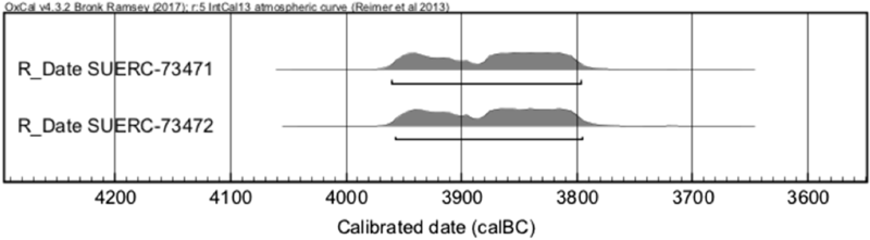
The New Barn Down samples were obtained from a large pit containing flint mining debitage, axes and Carinated Bowl pottery, ca. 600 m south of the Harrow Hill mines and provide the first dates for this site (Curwen Reference Curwen1934). The results (Figure 8) are not placed in an OxCal phase model here as there are just two radiocarbon measurements. They fall in the first quarter of the 4th millennium cal BC, with a 95.4% probability range of 3960–3800 cal BC and are consistent with the results of a phase model of the adjacent Harrow Hill flint mine that uses older radiocarbon results (see Figure S9), suggesting that the opening and backfilling of the New Barn Down pit coincides with the earliest mining activity at Harrow Hill.

Figure 8 New radiocarbon results from New Barn Down. Horizontal bars under the distributions are at a 95.4% probability range.
Easton Down, Winterslow, Wiltshire, in the Wessex Group of Neolithic Flint Mines
The Easton Down flint mines are located near East Winterslow, Wiltshire, northeast of Salisbury. The site was discovered by J.F.S. Stone in 1929 and excavated by him from 1930 to 1934 (Stone Reference Stone1932, Reference Stone1933, Reference Stone1935).
Figure 9 shows the Oxcal phase model for Easton Down, which differs from the other sites considered here in having a 95% start range that ends before 4000 cal BC, extending back before 5000 cal BC. More precisely, the model yields a start date range of 5560–4054 cal BC at a 95.4% probability range, while the 95.4% probability end range end date range is similarly long-tailed, in 3729–1714 cal BC at 95% with a median date of 3114 cal BC. See Figure S10 for a model using all available dates.

Figure 9 OxCal single phase model with new radiocarbon results from Easton Down. Horizontal bars under the distributions are at a 95.4% probability range.
2. Inter-site Comparison
The CalPal results for the new samples obtained are shown in Figure 10. The South Downs and Wessex distributions cover the range ~4000–3300 cal cal BC, as does Langdale. There are indications of a later phase of use ~2000 cal BC at Langdale, as there are at the South Downs site of Church Hill. It is clear that these represents a different phase of exploitation from the other mines and quarries. This may relate to the sourcing of Langdale tuff for archers’ bracers during the Beaker period and Early Bronze Age (Woodward and Hunter Reference Woodward and Hunter2011). See SI and Figure S11 for details of models including older results not included here for the sake of consistency (and see discussion below).

Figure 10 CalPal calibration model of new radiocarbon results.
Figure 11 brings together the start dates from the OxCal models presented above for individual sites. Results for six out of seven of the aggregated sites overlap at 2 sigma and suggest a synchronized start date for mining and quarrying around 4000–3700 cal BC. The New Barn Down results are modeled as phases here for comparison although they only have two dates per phase. See supplementary Figure S11 for details of models with older results not included here for the sake of consistency, but which confirm the tightly bracketed start dates ~4000 BC.

Figure 11 OxCal mine-start date model result using new radiocarbon data. Horizontal bars under the distributions are at a 95.4% probability range.
The modeled calibrated temporal span distributions for the sites are shown in Figure 12. Blackpatch is clearly short-lived on the preferred model, with a span of no more than 50 years. Cissbury, Long Down and Langdale span 250–750 years, while the spans of Easton Down and Church Hill on the available evidence are much longer.

Figure 12 OxCal model of the temporal span of sites in calendar years using new radiocarbon data. Horizontal bars under the distributions are at a 95.4% probability range.
3. Comparison of OxCal and CalPal Results
Despite the arguments and complexities, both OxCal and CalPal generally yield similar results (Aitchison et al. Reference Aitchison, Leese, Michczynska, Mook, Otlet, Ottaway, Pazdur, Van Der Plicht, Reimer, Robinson and Scott1989) although a critical comparison of the two can yield significant improvements for radiocarbon calibration model evaluation (Weninger et al. Reference Weninger, Clare, Jöris, Jung and Edinborough2015).
Due to the calibration algorithm OxCal can result in dramatically spiked calibrated date distributions when they are summed (Weninger et al. Reference Weninger, Clare, Jöris, Jung and Edinborough2015), as well as agreement indices (likelihood functions) which can sometimes make it difficult to evaluate competing chronological models (Riede and Edinborough Reference Riede and Edinborough2012; cf. Hamilton and Krus Reference Hamilton and Krus2018). In contrast, probabilistic CalPal models assume much less, and claim less precision than OxCal models in archaeological contexts. A CalPal model results in a calibrated histogram of a date probability distribution that sums to one—which is relatively easy to cross-compare.
When comparing the OxCal results for the mine and quarry dates in our sample and if the surprisingly long tailed distributions in the OxCal start models are ignored, the calibrated distributions at two standard deviations ate are tightly clustered. As the bulk of these results overlap at a 95.4% probability range, they suggest a synchronized start date for mining around 4000–3700 cal cal BC. The OxCal results are therefore in broad agreement with those from CalPal.
DISCUSSION
We present 39 new radiocarbon results from Neolithic mining and quarrying sites modeled with two different calibration methods. The results of both CalPal and OxCal calibration models are similar. They show that stone-quarrying and flint-mining activities in both the north and south of England began ~4000–3700 cal BC and that the great majority were in contemporary use in the early 4th millennium. The dates at mines have focused on deposition within individual shafts and this shows what would be expected for rapid and discrete extraction events. While some sites lasted longer than others and more could be gained from a wider sampling strategy, there is evidence of later phases of extraction at Church Hill, Long Down and Langdale although these are not contemporaneous with the late Neolithic mining at Grime’s Graves. The scatter of available dates from several other mine and quarry sites in Britain and Ireland not discussed in this paper (see Figure S11) show the same pattern, including Martin’s Clump flint mine in Wessex, the Graig Lwyd and Mynydd Rhiw quarries in North Wales, and the Tievebulliagh and Lambay Island quarries in Ireland. Dates from deposition contexts of axes from the petrologically-determined but unknown Cornish sources also fall in this range (Whittle et al. Reference Whittle, Healy and Bayliss2011).
The similarity of the start dates is not consistent with a pattern of independent local innovation of new mining and quarrying practices in different parts of Britain. They are consistent with an association with the immigrant groups from northwest Europe who introduced farming to Britain at this time (Brace et al. Reference Brace, Diekmann, Booth, van Dorp, Faltyskova, Rohland, Mallick, Olalde, Ferry, Michel and Oppenheimer2019). Farming groups in Brittany had been exploiting fibrolite for prestige axes imitating those from the Alps for much of the 5th millennium cal BC (Pailler Reference Pailler, de Labriffe and Thirault2012), while the dates from the metadolerite “A” source of Plussulien/Seledun in central Brittany indicate that quarrying to produce axes began here around, or shortly before, 4000 cal BC (Le Roux Reference Le Roux1999). Similarly, flint-mining also began in northwest Europe in the late 5th millennium. The complex shaft and gallery technology used at deep sites such as Spiennes and Jablines was also used at Cissbury, which likely required prior knowledge that had gradually been developed earlier (Baczkowski Reference Baczkowski2014).
Given that the axes produced at these sites were extensively distributed over considerable distances, and that they all began production at more or less the same time, it can be concluded that the production was responding to the abrupt appearance of a new demand on a considerable scale. This demand was sufficient to support the opening of a number of mines at the same time in the same local area of Sussex, for example, at the same time. In general, our data do not permit us to be very precise about end dates but there is no evidence that different mines replaced one another. Rather, production seems to continue at different sites for different lengths of time though all have faded out by the end of the Early Neolithic population boom phase (Shennan et al. Reference Shennan, Downey, Timpson, Edinborough, Colledge, Kerig, Manning and Thomas2013; Bevan et al. Reference Bevan, Colledge, Fuller, Fyfe, Shennan and Stevens2017).
While there may have been a symbolic/ritual dimension to some of the activities associated with flint mining and specialised quarrying in Britain, Schauer et al. (Reference Schauer, Shennan, Bevan, Cook, Edinborough, Fyfe, Kerig and Pearson2019; and see Woodbridge et al. Reference Woodbridge, Fyfe, Roberts, Downey, Edinborough and Shennan2014) show that their axe production was a response to the need to clear climax forests for agricultural activities by the immigrant farmers. The effectively simultaneous start of production both in the south of England and the north and west can be seen in this light. The colonization of Britain was extremely rapid and had already reached Scotland by 3800 cal BC (Whittle et al. Reference Whittle, Healy and Bayliss2011). The first colonists in the south of England would have had access to the products of the flint mines but as settlement expanded rapidly to the north and distances increased, contact with these exchange networks would have been lost; this is seen in the distribution of flint axes, which is largely restricted to the south of England, and the chalklands in particular (Pitts Reference Pitts1996). The beginning of quarrying at Langdale is linked with the provision of high-quality axes to large areas of the midlands and north, where group VI axes from the Langdale occur at high frequency (Clough and Cummins Reference Clough and Cummins1988).
Although its location might seem remote, it is much less so if we think of it in the context of a western spread of farming and farmers to Britain through the Irish Sea, rather than an overland spread from the south, or from the east coast. In the case of Langdale the beds of the rivers leading down from the mountains to the Irish Sea would have contained rocks that provided clues to the potential of the mountains (Bradley and Edmonds Reference Bradley and Edmonds1993: 201). From this western perspective, the quarries at Langdale and its start date becomes part of a broader pattern that includes the quarrying activity at the Graig Lwyd and Mynydd Rhiw sources on the Irish Sea coast of North Wales, and at Tievebulliagh and Lambay Island on the Irish coast (Figure S11), as well as at currently unknown sites in Cornwall. This would indicate a likely initial discovery and exploitation of rock sources by western colonists, perhaps specifically immigrants from Brittany, who were already familiar with hard rock quarrying techniques (cf. Le Roux Reference Le Roux1999; Sheridan Reference Sheridan, Armit, Murphy, Nelis and Simpson2003; Pailler Reference Pailler, de Labriffe and Thirault2012; Pioffet Reference Pioffet2015).
CONCLUSION
Due to the lack of new excavations of mines in the UK, our dating program is, of course, not exhaustive. Yet this collaborative project has more than doubled the existing suite of radiocarbon dates for the early Neolithic flint mines while producing more certainty for the chronology of the Langdale quarries. Overall, it has supported the dates gained from earlier dating programs and indicated the potential to more fully chronologically characterise the influx of immigrant farmers at the beginning of the Neolithic. This is particularly important as extraction activity is shown to pre-date monument building, whose construction begins at c. 3800 cal BC (Whittle et al. Reference Whittle, Healy and Bayliss2011). Extraction activity is therefore a primary expression of the Neolithic in the UK and Ireland (Barber et al. Reference Barber, Field and Topping1999: 68–69; Russell Reference Russell2000: 55–59, Reference Russell, Cotton and Field2004: 174–175; Barber Reference Barber, Topping and Lynott2005). The currently available data consistently show that in Britain mining and quarrying were a response to the demand created by the colonization of the first farmers, who brought relevant extraction technological knowledge with them. The subsequent decline in mining and quarrying reflects both a decrease in clearance activity and the population decline during the middle of the 4th millennium BCE (Bevan et al. Reference Bevan, Colledge, Fuller, Fyfe, Shennan and Stevens2017; Schauer et al. Reference Schauer, Shennan, Bevan, Cook, Edinborough, Fyfe, Kerig and Pearson2019). While this was initially suggested by Bradley (Reference Bradley1978) and Whittle (Reference Whittle1978), it is now supported through a range of recent work to produce a much clearer picture of the early Neolithic in Britain and Ireland (Shennan Reference Shennan2018).
ACKNOWLEDGMENTS
We are very grateful to the Leverhulme Trust for Research Project Grant RPG-2015-199 for the financial support that made this project possible. In addition, the NERC-AHRC National Radiocarbon Facility funded 10 radiocarbon dates on the Sussex mines through two small projects (NF/2015/2/17; NF/2017/1/11, led by Andrew Chamberlain). We wish to thank Phil Austin for his meticulous identification of short-lived species for our new Langdale radiocarbon samples. We thank Alex Bayliss for her sampling advice and loan of a dental drill at the start of this project. We also thank the Director of the Salisbury Museum, Adrian Green, Amy Roberts at the Novium Stores in Chichester and Gerry Connolly and James Sainsbury at Worthing Museum and Art Gallery, for access to their collections. At the University of Reading we thank Duncan Garrow. At University College London we thank Ulrike Sommer and Jon Sygrave for valuable discussions. Finally, we wish to thank the two anonymous reviewers of this paper for their detailed comments which have helped improve it considerably.
SUPPLEMENTARY MATERIAL
To view supplementary material for this article, please visit https://doi.org/10.1017/RDC.2019.85