


INTRODUCTION
Closed depressions within landslides are usually flooded, gradually overgrown with plants and filled with organic sediments, and finally become fens (usually minerogenic mires) (Margielewski Reference Margielewski2001, Reference Margielewski2006). Basins of this type are characterized by variable hydrogeological regimes typical of landslide areas (Dynowska Reference Dynowska1986; Margielewski Reference Margielewski2006). They constitute a specific sedimentary environment, characterized by frequent supplies of mineral/minerogenic material to the depositional basin, which temporarily stops peat sedentation and causes the deposition of mineral horizons. Such horizons, which are of variable thickness and character, reflect climate changes, mainly the climate humidity growth during the Late Glacial and the Holocene in mountainous areas. However, the final record of this depositional variability stems from a confluence of factors such as palaeoclimatic changes (climate humidity growth), human activity from prehistoric times, as well as the specifics of the depositional environment of these fens (usually rich fens). As a result, extreme hydrometeorological events such as excessive rainfalls, downpours and continuous rains, or a group of events related to a climatic phase, may be recorded in varying ways for respective mires, and even for particular sections of each landslide-rich fens (Margielewski Reference Margielewski2001, Reference Margielewski2006; Margielewski and Kovalyukh Reference Margielewski and Kovalyukh2003; Margielewski et al. Reference Margielewski, Michczyński and Obidowicz2010). Therefore, the correct interpretation of this record requires a proper arrangement of the record of events, a process that includes the differentiation of a single event from a group of events typical of a climate moistening phase. It is also important to distinguish between the record of climate changes and the record of changes caused by human activity, as well as to identify changes in sediments due to the specificity of the sedimentary environment (Margielewski Reference Margielewski2006). This, however, requires drilling numerous boreholes in the mires, using a wide range of sediment testing methods (palynological, telmatological, and sedimentological), as well as acquiring numerous radiocarbon (14C) dates for the depositional variability of the horizons.
THE STUDY AREA
The Carpathians form a mountain range which, in total, is 1300 km long (Figure 1A). The area of this particular study is located in the northern part of the Western Carpathians, in the Polish Outer Carpathians (Beskidy Mountains), mainly built of flysch formed during the Late Jurassic-Early Miocene periods (Książkiewicz Reference Książkiewicz1972; Oszczypko Reference Oszczypko2006). The folded flysch sediments formed large tectonic units overlapping one another and covering the foreland—the Magura, Dukla, Silesian, Subsilesian, Skole, and Stebnik Units (Książkiewicz Reference Książkiewicz1972; Oszczypko Reference Oszczypko2006). On the northern foreland of the Carpathians are Miocene deposits of the Carpathian Foredeep (Oszczypko Reference Oszczypko2006).
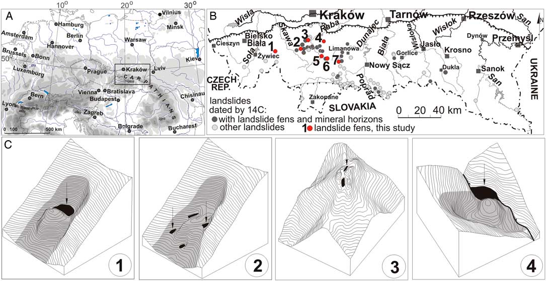
Figure 1 Location of the study area in (A) the Carpathian Chain and (B) the Polish territory, with distribution of dated landslides (including landslides with fens); (C) types of depressions formed in various parts of landslide forms: 1. depression at the foot of main scarp; 2. intercolluvial depressions; 3. top and ridge trenches; 4. landslide dam lake (after Margielewski Reference Margielewski1998, Reference Margielewski2006).
The relief of the Carpathians is the result of the lithology and tectonics of rock massifs, as well as the bedrock resistance (Starkel Reference Starkel1972). Its zonal character (Beskid relief zone to the south and the Foothill relief zone to the north; cf. Starkel Reference Starkel1972) is related to the tectonic system of the nappe stack formed during the compressional stage of the Carpathian tectonic evolution (Jankowski and Margielewski Reference Jankowski and Margielewski2014). Rocks weathered under periglacial conditions transformed by mass movements formed silty-gravel loam slope covers in the Quaternary (Starkel Reference Starkel1972).
The Carpathian climate is characterized by the zonation and variation of atmospheric circulations along the mountain range (Obrębska-Starklowa et al. Reference Obrębska-Starklowa, Hess, Olecki, Trepińska and Kowanetz1995). The western part is often subjected to oceanic air masses, whereas the eastern part is more affected by continental circulation. The mean annual temperature fluctuates between +8ºC and –4ºC. The mean annual precipitation ranges from 700 mm for the foothills, up to 1000–1300 mm for the Beskidy Mts. (Obrębska-Starklowa et al. Reference Obrębska-Starklowa, Hess, Olecki, Trepińska and Kowanetz1995).
MATERIALS AND METHODS
Peat sediment cores were sampled using an INSTORF Russian peat sampler with a diameter of 6 and 8 cm. Within each peat bog as many as 10–25 boreholes were drilled. Thirty landslide fens have been examined and the results have been published in previous papers (Margielewski Reference Margielewski2001, Reference Margielewski2003, Reference Margielewski2006; Margielewski and Kovalyukh Reference Margielewski and Kovalyukh2003; Margielewski et al. Reference Margielewski, Michczyński and Obidowicz2010, Reference Margielewski, Kołaczek, Michczyński, Obidowicz and Pazdur2011; Michczyński et al. Reference Michczyński, Kołaczek, Margielewski, Michczyńska and Obidowicz2013) (Figure 1B).
The loss on ignition (LOI) analysis was carried out for logs cut in sections 2.5 cm long, and then combusted at 550ºC in a muffle furnace, based on the standard procedure (Heiri et al. Reference Heiri, Lotter and Lemcke2001). The results are expressed as percentage curves (Figures 2A: 4 and 3B).
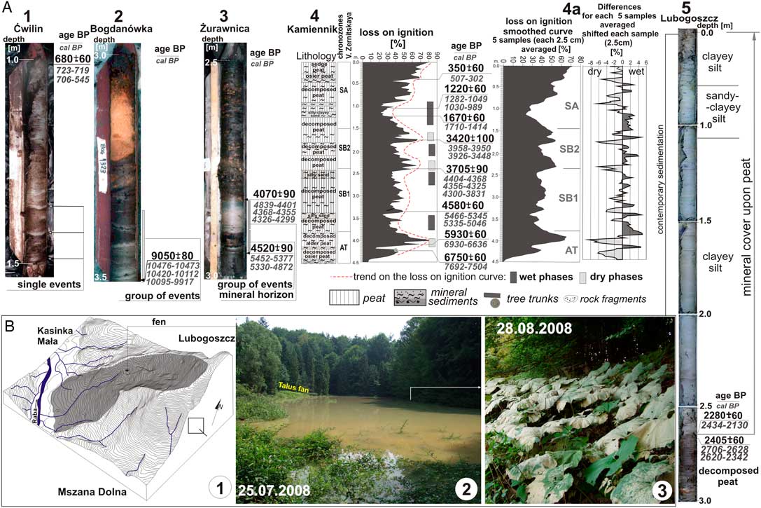
Figure 2 (A) Records (and their range) of various hydrometeorological events reflected as inserts of mineral sediments within selected Carpathian landslide fens: 1. record of single hydrometeorological event reflected as thin mineral horizons (Ćwilin fen, Beskid Wyspowy Mts.); 2. group of events—laminated organic-minerogenic deposits (Bogdanówka fen, Beskid Makowski Mts.); 3. laminated deposits and thick mineral horizon within organic deposits (Żurawnica fen, Beskid Makowski Mts.); 4. climatic changes detected on the basis of loss on ignition analysis of peat bog sequence (sampled for each 2.5-cm-long section of log) (Kamiennik fen, Beskid Wyspowy Mts.); 4a. (left) identification of palaeohydrological records reflected on LOI curve (point 4) for wet/dry climatic phases and presented as smoothed LOI curve (averages of 5 samples) and (right) curve of differences for each 5 samples averaged, shifted each sample (2.5 cm sequence of log); 5. thick mineral cover over the peat sequences, formed due to the climate humidity growth at the beginning of the Subatlantic Phase (Lubogoszcz fen, Beskid Wyspowy Mts.) (after Margielewski Reference Margielewski2006, supplemented). (B) current deposition of minerogenic sediments, overbuilding mineral cover of the Lubogoszcz fen (see part A, log 5): 1. hypsometric projection of landslide area; 2. fen covered by water pool due to the extreme rainfalls in 2008; 3. thin layer of mineral sediments covering plant leaves (this study). Photo by author.
Telmatological analyses (peat structure/tissue analyses) were performed on the basis of the light-microscopic analysis of macro-fossils occurring in peat samples. According to the previous literature, peat is organic sediment characterized by ash (mineral) content not exceeding 35% (cf. Tobolski Reference Tobolski2000). However, the part of sediments of landslide fens are rich in mineral component representing more than 35% of their content and, consequently, do not fulfill criteria of peat definition. Nevertheless, in this paper all samples containing organic material in which the occurrence of macrofossils made possible the description of plant associations are described as peat (see Margielewski Reference Margielewski2006).
The grain size of mineral sediments in the peat bogs was analyzed using sieve and areometric Bouyoucos-Casagrande methods (Mycielska-Dowgiałło and Rutkowski Reference Mycielska-Dowgiałło and Rutkowski1995), whereas the type of sediment was determined according to the classification proposed by Pettijohn (Reference Pettijohn1975).
Conventional 14C dating of organic material (for the depositional variability of horizons) using the liquid scintillation counting (LSC) method was carried out in the radiocarbon laboratories in Kiev (Ukraine), Minsk (Belarus), Gliwice (Poland) and Kraków (Poland). Samples were chemically pretreated using the acid-alkali-acid method. AMS dates were measured in the laboratories in Poznań (Poland), Gliwice (Poland), and Seatle (USA). The materials dated included peat, wood detritus, and charcoal sampled (during field work or laboratory treatments) from the horizons of lithological changes. The calibration of 14C datings with a probability of 95% was performed with the OxCal calibration program, v4.2 (Bronk Ramsey Reference Bronk Ramsey2009), and the IntCal13 calibration curve (Reimer et al. Reference Reimer, Bard, Bayliss, Beck, Blackwell, Bronk Ramsey, Buck, Cheng, Edwards, Friedrich, Grootes, Guilderson, Haflidason, Hajdas, Hatté, Heaton, Hoffmann, Hogg, Hughen, Kaiser, Kromer, Manning, Niu, Reimer, Richards, Scott, Southon, Staff, Turney and van der Plicht2013). Using the applications and datasets mentioned above, the cumulative probability density function (CPDF) was constructed (c.f. for example Starkel et al. Reference Starkel, Soja and Michczyńska2006, Reference Starkel, Michczyńska, Krąpiec, Margielewski, Nalepka and Pazdur2013; Margielewski Reference Margielewski2006). For the CPDF construction of mineral horizons dating distribution, 108 representative datings were selected from over than 180 records: one dating was selected for one mineral horizon in each fen. The dates reported previously by the author (Margielewski Reference Margielewski1998, Reference Margielewski2001, Reference Margielewski2003, Reference Margielewski2006; Margielewski and Kovalyukh Reference Margielewski and Kovalyukh2003; Margielewski et al. Reference Margielewski, Michczyński and Obidowicz2010, Reference Margielewski, Kołaczek, Michczyński, Obidowicz and Pazdur2011; Margielewski and Urban Reference Margielewski and Urban2017) are supplemented with new datings of mass movement forms and deposits (Figure 4B: columns 1, 3, and 4).
Pollen analyses performed for chosen logs sampled at 5–10-cm intervals were reported in previous publications (Margielewski Reference Margielewski2001, Reference Margielewski2003, Reference Margielewski2006; Margielewski et al. Reference Margielewski, Michczyński and Obidowicz2010, Reference Margielewski, Kołaczek, Michczyński, Obidowicz and Pazdur2011; Michczyński et al. Reference Michczyński, Kołaczek, Margielewski, Michczyńska and Obidowicz2013). Every sample of 1 cm3 was prepared according to the procedure outlined by Berglund and Ralska-Jasiewiczowa (Reference Berglund and Ralska-Jasiewiczowa1986). The fundamental purpose was to mark the boundaries of chronozones for the profiles under analysis, identify sedimentary hiatuses, and trace human activity.
Daily precipitation data series (used for the present sedimentation analysis) were obtained from the Institute of Meteorology and Water Management, National Research Institute, Warsaw.
SPECIFICITY OF THE DEPOSITIONAL ENVIRONMENT OF LANDSLIDE FENS
Types of Landslide Depressions
Depressions, in which mires are formed, develop most frequently at the foot of the main scarp during primary landslide mass movements (Figure 1C: 1; Figure 3A: 1–5) (Alexandrowicz Reference Alexandrowicz1996; Margielewski Reference Margielewski1998). The vicinity of steep and high main scarp of the landslide considerably increases the frequency and dynamics of mineral material supplies to the basin. The main scarp is often cut with permanent or ephemeral watercourses that formed vast alluvial fans at its foot (Margielewski Reference Margielewski2006).

Figure 3 Specificity of the landslide fens depositional environment. Records of the climate humidity growth in deposits of selected landslide fens in the Carpathians, reflected on loss on ignition curve of logs. Differentiation of records in the peat bog sequences accumulated: 1. since the Late Glacial (Klaklowo fen; Beskid Makowski Mts.); 2. since the beginning of the Holocene (Bogdanówka fen, Beskid Makowski Mts.); 3. since the Atlantic Phase (Żurawnica fen, Beskid Makowski Mts.); 4. since the Early Subboreal Phase (reflected as illuvial horizons only—Mt. Mogielica fen, Beskid Wyspowy Mts.); 5. deposits of landslide fen of Mt. Ćwilin accumulated during the Subatlantic Phase. Above the logs (A)—morphological position of fens (1–5) in the landslide forms (projection of hypsometry). Examples after Margielewski (Reference Margielewski2001) (1), Margielewski (Reference Margielewski2006) (2–4), Margielewski and Kovalyukh (Reference Margielewski and Kovalyukh2003) (5), supplemented. Hiatuses were detected on the basis of pollen analysis and the 14C dating distribution. Pollen chronozones were determined by V. Zernitskaya.
Intercolluvial depressions present in various parts of the colluvium might have developed both during primary and secondary mass movements in the landslide (Figures 1C: 2, and 2B) (Margielewski Reference Margielewski1998). Sediment supply areas of depositional basins are rich in mineral sediments (colluvium). Depressions in the top trenches develop throughout the primary mass movements (Figure 1C: 3) (Alexandrowicz Reference Alexandrowicz1996).
Other types of landslide basins include dam lakes that are created when river valleys are dammed by landslides (Figure 1C: 4) (Alexandrowicz Reference Alexandrowicz1996). Nevertheless, peat bogs around these basins rarely develop (Alexandrowicz Reference Alexandrowicz2006; Pánek et al. Reference Pánek, Smolková, Hradecký, Baroň and Šilhán2013).
Landslide Fen (Landslide Mire)
For classification, mires formed in landslide depressions fall into the category of mountain rich fens comprising minerogenic mires (Kaule and Göttlich Reference Kaule and Göttlich1976; Obidowicz Reference Obidowicz1985; Obidowicz and Margielewski Reference Obidowicz and Margielewski2008; Rydin and Jeglum Reference Rydin and Jeglum2013; Kołaczek et al. Reference Kołaczek, Margielewski, Gałka, Apolinarska, Płóciennik, Gąsiorowski, Buczek and Karpińska-Kołaczek2017). The specific features that characterize them are their long-term deposition under snow cover, a two- or threefold increase in total annual precipitation when compared with the foreland of the mountains, and abundant supplies of organic sediments with mineral content (Ringler Reference Ringler1978; Obidowicz Reference Obidowicz1985). The hydrological typology of these mires is not uniform given their considerable variety, as they are of different types, usually complex-type mires (Kaule and Göttlich Reference Kaule and Göttlich1976; Tobolski Reference Tobolski2000). In general, these are soligenic mires, supplied by an underground spring, capillary, and flow-through waters (Margielewski Reference Margielewski2006; Obidowicz and Margielewski Reference Obidowicz and Margielewski2008; Rydin and Jeglum Reference Rydin and Jeglum2013). On the other hand, due to the character of the accumulation of organic sediments in water-filled landslide depressions, they develop as a result of the overgrowth and terrestrialization of water bodies and peat accumulation within their bounds; these are mainly moss fens, sedge-moss fens, sedge, and woody-types (Margielewski Reference Margielewski2006), and they fall into the category of topogenic-type mires (cf. Kaule and Göttlich Reference Kaule and Göttlich1976; Żurek Reference Żurek1987). During the earliest stages of development, some of them evolve into poor fen (ombro-minerogenic mires). Sometimes, as a result of extreme fluctuations of the groundwater level, ombrogenic peat can be found in these mires (temporary formed as poor fens) at the bottom of rich fen-type peats or in their middle sections (Figure 3B: 2) (Margielewski Reference Margielewski2006).
A specific feature of mires at landslide depressions is the mobility of the sediment supply area and thus the related supply of allochthonous (minerogenic) material, mainly during climate moistening phases (Figure 2B: 2–3). The mineral material supplied to landslide-rich fens may create illuvial horizons in peats, mineral horizons within their bounds, or mineral covers of the peat top (Figures 2A and 3B: 1–3). In the latter case, these covers constitute an integral part of the sediment accumulation within rich fens (minerogenic mires). Peat sedentation would usually resume on their surfaces (Figure 2A: 5), therefore these fens are not classified as buried peatlands (cf. Kaule and Göttlich Reference Kaule and Göttlich1976; Obidowicz Reference Obidowicz1985).
During extreme rainfalls, mires at landslide depressions would often be flooded with water (Figure 2B: 2). Usually, the water was discharged due to underground drainage, but surface drainage might also have caused the removal of some peat deposits owing to the erosion. At that time, depositional breaks would occur, referred to as erosive hiatuses (Margielewski Reference Margielewski2006). The analysis of the peat growth rate for the selected landslide fens in the Carpathians indicates a major variation of the accumulation rate at the respective mires, as well as in the depositional sequences (from 5 mm/yr to 0.3 mm/yr) (Żurek Reference Żurek1986; Margielewski Reference Margielewski2006).
Due to the character of the landslide basins in which they develop, the specificity of the hydrological regime, as well as the type and character of sedimentation within their bounds, the described mires constitute a separate type of mountain fens, to be more specific, landslide fens (Margielewski Reference Margielewski2006; Margielewski and Obidowicz 2008).
Sedimentary Records Affected by Various Factors: Slope–Lacustrine Facies Specificity
The depositional environment of landslide fens is characterized by significant dynamics. This stems from both their peculiar hydrological regime and the significant mobility of the mineral material within the sediment supply area. What distinguishes lacustrine sediments is the continuous depositional sequence of paleoenvironmental changes (however, sedimentary hiatuses may occur) including, in particular, climate changes related to the impact of the hydrometeorological factors. It then appears that this record should be clear as the bodies of water located high in the mountains are a climate change indicators sensitive to the increased impact of extreme rainfalls (Kotarba and Baumgart-Kotarba Reference Kotarba and Baumgart-Kotarba1997; Margielewski Reference Margielewski1998, Reference Margielewski2006; Dapples et al. Reference Dapples, Lotter, Van Leeuwen, Van der Knapp, Dimitriadis and Oswald2002; Zolitschka et al. Reference Zolitschka, Behre and Sneider2003; Borgatti et al. Reference Borgatti, Ravazzi, Donegana, Corsini, Marchetti and Soldati2007; Borgatti and Soldati Reference Borgatti and Soldati2010; Pánek et al. Reference Pánek, Smolková, Hradecký, Baroň and Šilhán2013; Kołaczek et al. Reference Kołaczek, Margielewski, Gałka, Apolinarska, Płóciennik, Gąsiorowski, Buczek and Karpińska-Kołaczek2017). The break of peat sedentation and sedimentation of mineral horizons in peats should, therefore, be a clear reaction of the sedimentary environment of rich fen to the climate humidity growth.
An analysis of the profiles of landslide fens indicates that the continuity and readability of the (global/regional) climate change records is skewed by local conditions, deriving from the specificity of the depositional environment (and changes of the landslide hydrological regime related to this environment), removal of certain sediments due to erosion or even human activity. In effect, the record of successive climatic phases within respective mires may vary considerably (Figure 3B: 1–5).
Other difficulties in interpretation stem from the identification and arrangement of the record of events affected by hydrometeorological factors (Figure 2). Theoretically speaking, lithological changes should reflect the character, intensity and time of the impact of precipitation in the profile sequences: event—group of events—humid phase records (Margielewski Reference Margielewski2006; Starkel Reference Starkel2006). Nonetheless, aside from the clear record of the group of phase events, such as laminated peat and mineral formations (Figure 2A: 2–3), thick mineral horizons in peats (Figure 2A: 3) or long-term lithological changes in sediments, identifiable on the basis of loss on ignition curves (Figure 2A: 4–4a), sediments can also provide a record of single events, reflected in the form of thin mineral or illuvial horizons in peats (Figures 2A: 1 and 2B).
Therefore, the characteristics of the record of events in landslide fen sediment results from both the impact of climatic factors on a regional (and local) scale and specificity of the depositional environment, including the rejuvenation of landslides (Starkel Reference Starkel1997; Margielewski Reference Margielewski2006; Pánek et al. Reference Pánek, Smolková, Hradecký, Baroň and Šilhán2013). In certain cases, anthropogenic impact on the Carpathians, which began as early as in the prehistoric times, should also be taken into account. Local fires ignited by humans clearing forests for cultivation could have sped up the surficial flow, development of linear erosion and transport of debris (Starkel Reference Starkel1988, Reference Starkel2006; Margielewski Reference Margielewski2006; Margielewski et al. Reference Margielewski, Michczyński and Obidowicz2010). All these factors have affected the specificity of “slope facies” of landslides (Margielewski Reference Margielewski2006), where the record of events is much less clear than for fluvial (flood) facies (Starkel et al. Reference Starkel, Kalicki, Krąpiec, Soja, Gębica and Czyżowska1996, Reference Starkel, Michczyńska, Krąpiec, Margielewski, Nalepka and Pazdur2013) or lacustrine facies (Ralska-Jasiewiczowa and Starkel Reference Ralska-Jasiewiczowa and Starkel1988; Kotarba and Baumgart-Kotarba Reference Kotarba and Baumgart-Kotarba1997).
RESULTS AND DISCUSSION
Characteristics of the Supply of Mineral Sediments to the Landslide Fens (Mires)
The supply of allochthonous (mineral) material to the landslide fens occurred in various ways. Predominantly, it was a dispersed (cover-type) surficial flow, which can still be observed today (Figure 2B). Linear furrows were also frequent. Mineral material was then supplied to the rich fens in the form of alluvial fans. The basin, periodically flooded on account of heavy rains, was supplied with mineral material in the form of suspension, from which it was precipitated (Figure 2B: 2–3). As a result of this process, silty deposits were fed to mires, the deposits mainly consisting of washed weathering material, usually with a small content of coarse fraction (Margielewski Reference Margielewski2006). In turn, on account of the bedrock being cut by watercourses supplying the depositional basin and forming alluvial fans, the basins were supplied with sediments containing clayey fractions (Margielewski Reference Margielewski2006). Apart from periods of continuous and extreme rains, the mineral material supply to the basin could also have taken place during spring snowmelts.
Records of the Palaeoclimatic Changes in Landslide Fen Deposits
The deposition process at mires formed in landslide depressions varies depending on climate changes and, as such, the record of climate changes varies between respective mires (Figure 2A: 2–4a and Figure 3B). The record of events may also be distinct in other parts of the same fen (Margielewski Reference Margielewski2006). Furthermore, a confluence of factors (climatic conditions, human activity, sedimentary environment specificity, etc.) may skew the record of climate changes, thus rendering it unclear. Some extreme events, registered due to depositional variability, might also have been unrelated to any climate moistening phase and occurred on a non-phase basis (Margielewski Reference Margielewski2006; Starkel Reference Starkel2006). Consistently, a matter essential for interpretation is the arrangement of respective records of lithological changes within the sequence of sediments in order to identify the record in sediments of single extreme events, groups of events or climatic phases (Margielewski Reference Margielewski2006; Starkel Reference Starkel2006). Similarly, the beginning of the formation of mineral covers on peats or hiatuses in sediments may provide information useful for palaeoclimatic reconstructions (Figure 2A: 5 and Figure 3B: 1–3). What may also be of use while arranging the record of climate changes in sediments are palynological analyses as well as numerous 14C dates.
A Record of Single Events
In many terrestrial environments during the Holocene (fluvial, lacustrine, slope, aeolian), it is frequently difficult to unambiguously identify a single event record, especially when characterized by a varied intensity and duration (e.g. Starkel et al. Reference Starkel, Kalicki, Krąpiec, Soja, Gębica and Czyżowska1996).
A single event (extreme or continuous rainfall) that results in water flooding and deposition of mineral sediment from the suspension may cause a very thin layer of mineral sediment (0.5–5.0 mm) to be deposited on the surface of the landslide fen (Figure 2A: 1 and Figure 2B) (Margielewski Reference Margielewski2006). However, this is not a rule. At the landslide-rich fen on Mt. Lubogoszcz, in the Beskid Wyspowy Mts. (Figure 1B: site 5), owing to the continuous rains in July 2008 (113 mm from 25 to 29/07, as recorded by the nearby Węglówka Station), the thickness of mineral sediments deposited from the suspension on the peat bog surface was 0.5 mm (Figure 2B: 1–3). In contrast, after the continuous and extreme rains in July 2014 (120 mm from 20 to 24. 07, as registered by the same station), which caused flooding of the mire and a considerable supply of mineral material, the thickness of the deposited mineral sediments (clayey silt) reached as much as 40 mm (Margielewski Reference Margielewski2006). Since the basin was flooded owing to another extreme rainfall on 5 August 2014 in the vicinity of Mt. Lubogoszcz (in total 95.6 mm of daily precipitation, as registered by the nearby Węglówka Station), and due to the intense supplies of mineral sediment from the slopes in the form of an extensive talus fan (Figure 2B 2), 20 mm of sediment was deposited on the surface of this peatland. As such, the character of the single event record is only difficult to infer from the thickness of the mineral sediment layer in peats.
A Record of the Humid Climatic Phase: Laminated Sediments
A clear record of repeatable hydrometeorological phenomena related to phase of climate moistening are laminated sediments, consisting of numerous, usually thin, mineral layers, separated with organic layers (Figure 2A: 1–2). They indicate that periods of precipitation alternated with drier periods, during which the accumulation of peats occurred. At the landslide fen this type of record will—in simple terms—be a counterpart of the lithological record of repeated river floods (Starkel et al. Reference Starkel, Kalicki, Krąpiec, Soja, Gębica and Czyżowska1996). For example, the types of laminated sediments (thickness of mineral laminae from 0.3 to 10 mm) can be found in the depositional sequence of Bogdanówka site, Beskid Makowski Mts., where it is attributable to the climate moistening at the end of the Preboreal Phase and at the beginning of the Boreal Phase (Figure 1B: site 2 and Figure 2A: 2). As regards the profile of the peat bog at the Żurawnica site, also in the Beskid Makowski Mts., the laminated sediments are attributable to the more humid climate in the beginning of the Subboreal Phase (Figure 1B: site 1, Figure 2A: 3, and Figure 3B: 3).
A Record of the Humid Climatic Phase: Thick Mineral or Illuvial Horizon in Peats
Thick (10–30 cm) mineral horizons in peat provide a clear record of the climate humid phase. The 14C dates, as well as the palynological analysis, indicate that a break of peat sedentation and supply of allochthonous material to the examined mires occurred during the phase of climate moistening for a longer period. One example of such a record in sediments deposited during the periodic climate humidity growth is the mineral horizon (clayey silt) in the sequence at the aforementioned fens at the Żurawnica site, formed during climate humidity growth in the Early Subboreal Phase (Figure 2A: 3). These horizons also developed in the Late Glacial sequences of the Klaklowo mire, Beskid Makowski Mts. (Figure 1B: site 3 and Figure 3B:1), or the Boreal/Atlantic sequences of the Bogdanówka site, Beskid Makowski Mts. (Figure 1B: site 2 and Figure 3B: 2), as well as in the sequence deposited at the beginning of the Subatlantic Phase at the landslide fen on Mt. Kamiennik, Beskid Wyspowy Mts. (Figure 1B: site 4 and Figure 2A: 4–4a) (Margielewski Reference Margielewski2006).
Thick illuvial horizons in peats (or their series) identified in loss on ignition curves (Figure 3B: 4) are indicators of phases of climate humidity growth analogous to the mineral horizons. These horizons are produced by the supply of mineral sediment to the depositional basin, without the simultaneous interruption of peat sedentation. Peats accumulated at that time are, to varying degrees, contaminated with mineral sediments. Such illuvial horizons have been observed in the sequence of Mt. Mogielica, Beskid Wyspowy Mts. (Figure 1B: site 7 and Figure 3B: 4). These horizons accurately reflect the climate moistening phases in the Early Subboreal, Middle Subboreal, and at the beginning of the Subatlantic Phase.
A Record of the Humid Climatic Phases: Trends in Loss on Ignition Curves
The records of phase climate changes can easily be observed from trends in loss on ignition curves of deposits, which reflect the cyclicity of supplies and changes in their intensity over time. Therefore, long-term phases of increased humid periods result in the periodic decline of loss on ignition curves, which can be observed from these curves (Figure 2A: 4 and Figure 3B).
The shape of loss on ignition curves usually indicates several moistening phases, alternating with dry phases (Figures 2A: 4–4a and Figure 3B: 1–5). Here, climate humidity increases are registered in the forms of long-term higher ash content reflected in the loss on ignition curves: the constant supply of allochthonous material causes the increase of the mineral matter share in the peats. On the other hand, dry climatic phases are reflected in the curves as an increased loss on ignition of sediment: more organic peat was accumulated at that time (Figure 2A: 4). A good resolution of the records of humid and dry phases in sediments can be achieved by smoothing a loss on ignition curve (averaging LOI values for several neighbouring trials) or by plotting curves of differences between averaged samples (3; 5 or more samples) (Figure 2A: 4a).
Particularly evident in the landslide fen sediments is increased humidity, permafrost melting and the beginning of water circulation in the Late Glacial. This is accurately reflected by the course of the loss on ignition curve of Klaklowo, Beskid Makowski Mts. (Figures 1B: site 3 and Figure 3B: 1) (Margielewski Reference Margielewski2001). A similar trend can be observed during the Preboreal Phase of the Holocene (Figure 3B: 1–2). The especially intense climate moistening at the turn of the BO/AT (Figure 3B: 2) and AT/SB phases (Figure 3B: 2–3) is also faithfully reflected in the loss on ignition curves.
The varied resolution of the humid climatic phase records across the respective mires is confirmed by the range of changes provided by the sequence of landslide fen on Mt Ćwilin, Beskid Wyspowy Mts., formed at the beginning of the Subatlantic Phase (Figure 1B: site 6 and Figure 3B: 5) (Margielewski and Kovalyukh Reference Margielewski and Kovalyukh2003). The significant climate moistening at the beginning of the Subatlantic Phase is observed in the depositional sequences as a single mineral or illuvial horizon (Figure 2A: 4–4a and Figure 3B: 4) or mineral cover on the peat bog (Figure 3B: 1–3). However, in the Mt. Ćwilin mire sequence, during the Subatlantic Phase several mineral horizons were formed, reflecting a repeated climate humidity growth within the past 2.6 thousand years (Figure 3B: 5 and Figure 4B: column 2) (Margielewski and Kovalyukh Reference Margielewski and Kovalyukh2003).

Figure 4 (A) Distribution of dated landslide forms and deposits in the Polish Carpathians (after Margielewski Reference Margielewski2006, supplemented); (B) correlation of time formation of landslide forms and deposits (site location on part A) on the basis of concentration of 14C datings (reflected as cumulative probability density function) with events related to the climate moistening and cooling. 1–2. distribution of 14C datings of mineral horizons in four logs of selected landslide fens (this study); 3. dated mineral horizons in the Polish Carpathians landslide fens (representative datings) (after Margielewski Reference Margielewski2006, supplemented in Starkel et al. Reference Starkel, Michczyńska, Krąpiec, Margielewski, Nalepka and Pazdur2013 and in this study); 4. dated landslides in the Polish Carpathians (datings after various authors; see Gil et al. Reference Gil, Gilot, Szczepanek, Kotarba and Starkel1974; Alexandrowicz Reference Alexandrowicz1996; Wójcik Reference Wójcik1997; Haczewski and Kukulak Reference Haczewski and Kukulak2004, and the database in Margielewski Reference Margielewski1998, Reference Margielewski2006; Starkel et al. Reference Starkel, Michczyńska, Krąpiec, Margielewski, Nalepka and Pazdur2013, supplemented in this study); 5. dated speleothems in gravity induced caves in the Polish Carpathians (respecting reservoir effect) (after Margielewski and Urban Reference Margielewski and Urban2017); 6. dated landslides in the Polish and the Czech Carpathians (Pánek et al. Reference Pánek, Smolková, Hradecký, Baroň and Šilhán2013); 7. colluvial deposits age in Germany (after Hoffmann et al Reference Hoffmann, Lang and Dikau2008); 8. phases of Vistula River activity (Starkel et al. Reference Starkel, Michczyńska, Krąpiec, Margielewski, Nalepka and Pazdur2013); 9. glacial advances in the Alps (Bortenschlager Reference Bortenschlager1982, calibration age; see Starkel et al. Reference Starkel, Soja and Michczyńska2006); 10. Mid-Europe lakes high level water (Magny et al. Reference Magny, Begeot, Guiot and Payron2003); 11. frequency of cold/warm and wet/dry events in the Northern Hemisphere (after Wanner et al. Reference Wanner, Mercolli, Grosjean and Ritz2015, modified). Bond’s cooling events after Bond et al. (Reference Bond, Showers, Cheseby, Lotti, Almasi, Demenocal, Priore, Cullen, Hajdas and Bonani1997). Chronozones after Mangerud et al. (Reference Mangerud, Andersen, Berglund and Donner1974), Starkel et al. (Reference Starkel, Michczyńska, Krąpiec, Margielewski, Nalepka and Pazdur2013), and (for the Late Glacial) Litt et al. (Reference Litt, Brauer, Goslar, Merkt, Bałaga, Mueller, Ralska-Jasiewiczowa, Stebich and Negendank2001).
Mineral Covers on Peat Sequences
In a significant number of the analyzed fens, mineral cover of various thickness, age, and type of sediments occur. Their deposition was a result of a permanent change in sedimentary conditions of natural (hydrological changes) or partly anthropogenic character (Margielewski Reference Margielewski2006). The beginning of the deposition of these covers—deposited for several thousand years, usually to date—has always been linked with significant climate moistening at the dawn of the following phases: Boreal, Atlantic, Subboreal, or Subatlantic, more rarely with the climate cooling and moistening during the Little Ice Age (Margielewski Reference Margielewski2001, Reference Margielewski2006). The most numerous are these covers deposited during the Subatlantic Phase (Figure 2A: 5 and Figure 3B: 1–3) (Margielewski Reference Margielewski2001, Reference Margielewski2006). Therefore, the 14C and palynological analysis of the beginning of the deposition of these covers may be helpful in the reconstruction of the moistening phases during the Late Glacial and Holocene. Climate changes can also be manifested in changes in the grain size of the sediments. Relatively coarse sediments, such as silty sand or sandy clayey silt, which are high-energetic deposits sensu Kotarba (Reference Kotarba1996), within silty clay or clayey silt sequences, can indicate the increased intensity of the erosion processes in the vicinity of the peatland, caused by increased climate humidity (Margielewski Reference Margielewski2006). Such variation has been observed, for instance, in a part of the mineral cover at the rich fen at Mt. Lubogoszcz site (Figure 1: site 5 and Figure 2A: 5).
Hiatuses
In sediments of landslide fens, one can frequently observe depositional breaks that confuse the continuity of the event records. Their presence in a sequence can be determined only by performing a full pollen analysis of the deposits, supplemented (confirmed) with the 14C datings (Figure 3B: 1–2) (Margielewski Reference Margielewski2001, Reference Margielewski2006). It is typical that in the light of the 14C dates and palynological analyses available, the depositional breaks in the analyzed profiles would always occur during climate moistening phases. In horizons with hiatuses, a transition zone can frequently be observed, identified by use of the palynological method and characterized by substantial corrosion and disintegration of deposit pollen grains (Margielewski Reference Margielewski2006; Margielewski et al. Reference Margielewski, Michczyński and Obidowicz2010).
Decomposed peat has been observed around many of the depositional hiatuses (Margielewski Reference Margielewski2006). However, in the case of mountain peatlands they are not indicative of peat dryness (with the simultaneous lack of its sedentation—cf. Tobolski Reference Tobolski2000). Here, peat disintegration (decomposition) is a result of an impact of oxygen-rich aggressive waters fast flowing down the slope on organic sediments (Obidowicz Reference Obidowicz1985; Margielewski Reference Margielewski2006). As regards the analyzed landslide fens, the peat disintegration horizons are often accompanied by the pollen of aquatic plants, which indicate the rise of the water table at these mires (Margielewski Reference Margielewski2006). Therefore, irrespective of various hypotheses about depositional breaks in mire sediments, including a continued lack of peat sedentation (cf. Kaule and Göttlich 1973; Żurek Reference Żurek1987; Tobolski Reference Tobolski2000), in the case of mountain fens the most plausible hypothesis seems the notion that some sediments have been removed as a result of erosion and periodic opening of the depositional basins (cf. Zolitschka et al. Reference Zolitschka, Behre and Sneider2003). Thus, interpreted depositional breaks (hiatuses) in sediments provide essential knowledge about the hydrological changes around the depositional basins caused by increased climate moistening (Margielewski Reference Margielewski2006).
Records of Palaeoclimatic Changes in Landslide Fens
The cumulative probability density function (CPDF) of 14C dates for the depositional variability of landslide fens indicates that the supply of mineral sediment to landslide depressions and the formation of mineral and illuvial horizons in sediments, or the beginning of the formation of mineral peat covers, occurred during the climate moistening in the Late Glacial and the Holocene. It is plainly evident for both the distribution of the 14C datings for several sequences within the selected landslides (applicable to such mires as Bogdanówka and Mt. Ćwilin, where a series of 14C dates were performed for mineral horizons identified in four logs) (Figure 4B: columns 1 and 2), and representative dates for mineral horizons in the 30 landslide fens in the Carpathians (Figure 4B: column 3) examined so far (Margielewski Reference Margielewski2001, Reference Margielewski2003, Reference Margielewski2006; Margielewski et al. Reference Margielewski, Michczyński and Obidowicz2010, Reference Margielewski, Kołaczek, Michczyński, Obidowicz and Pazdur2011; Michczyński et al. Reference Michczyński, Kołaczek, Margielewski, Michczyńska and Obidowicz2013).
The mineral horizons were formed during the moistening and warming phases in the Late Glacial (Bølling and Allerød Interstadials) and at the beginning of the Holocene (climate warming and moistening in the Preboreal) when permafrost melting occurred. The ensuing stages, during which mineral or illuvial horizons were formed in peats, as well as the mineral covers started to form, took place in the climate moistening and cooling at the turn of the Boreal and Atlantic Phases, during the climate moistening and warming in the Atlantic climatic optimum, during the intense climate moistening (and cooling at the same time) at the end of the Atlantic Phase, at the beginning of the Subboreal Phase, and halfway through it, at the beginning and middle of the Subatlantic Phase (ca. 1.0–1.2 ka cal BP), and during the Little Ice Eppoch (Figure 4B: column 3) (Margielewski Reference Margielewski2006).
The stages of mineral horizon formation at landslide fens across the Carpathians (Margielewski Reference Margielewski2006; Starkel et al. Reference Starkel, Michczyńska, Krąpiec, Margielewski, Nalepka and Pazdur2013) are well correlated with the phases of mass movement activity (landslide phases) in the Polish Carpathians, marked on the basis of 14C datings for respective landslides (Gil et al. Reference Gil, Gilot, Szczepanek, Kotarba and Starkel1974; Alexandrowicz Reference Alexandrowicz1996, Reference Alexandrowicz1997; Starkel Reference Starkel1997; Wójcik Reference Wójcik1997; Margielewski Reference Margielewski1998, Reference Margielewski2006; Haczewski and Kukulak Reference Haczewski and Kukulak2004), or on the basis of the cumulative probability density function for these datings (Figure 4B: column 4) (Margielewski Reference Margielewski2006; Starkel et al. Reference Starkel, Michczyńska, Krąpiec, Margielewski, Nalepka and Pazdur2013), also taking into account landslides in the Polish, Czech, and Slovak Carpathians (Figure 4B: column 6) (Pánek et al. Reference Pánek, Smolková, Hradecký, Baroň and Šilhán2013), and colluvial deposits age in Germany (Figure 4B: column 7) (Hoffmann et al. Reference Hoffmann, Lang and Dikau2008). Phases of mineral horizon formation are also well correlated with stages of gravity-induced cave formation or transformation (preceding mass movements), based on dated speleothems (considering also changes from their concentric to eccentric growth) (Figure 4B: column 5) (Margielewski and Urban Reference Margielewski and Urban2017). Similarly, these horizons are accurately correlated with the phases of increased fluvial activity of the Upper Vistula River (Figure 4B: column 8) (Starkel et al. Reference Starkel, Michczyńska, Krąpiec, Margielewski, Nalepka and Pazdur2013), as well as phases of climate moistening and cooling for various sedimentary facies across Poland and Europe (Figure 4B: columns 7–10) (Bortenschlager Reference Bortenschlager1982; Magny et al. Reference Magny, Begeot, Guiot and Payron2003; Hoffmann et al. Reference Hoffmann, Lang and Dikau2008; Starkel et al. Reference Starkel, Michczyńska, Krąpiec, Margielewski, Nalepka and Pazdur2013), as well as in the Northern Hemisphere (Figure 4B: column 11) (Bond et al. Reference Bond, Showers, Cheseby, Lotti, Almasi, Demenocal, Priore, Cullen, Hajdas and Bonani1997; Wanner et al. Reference Wanner, Mercolli, Grosjean and Ritz2015).
CONCLUSIONS
Within sediments of analyzed landslide fens (landslide mires), a range of climate humidification events were registered to have occurred during the Late Glacial and Holocene, sometimes coupled with human activity (dated as early as prehistoric times). However, this record’s clarity varies depending on the character and scope of climate changes, human impact, and the specificity of the depositional environment of the mire depositional basins. Therefore, what is important is the correct interpretation of the lithological records in the sediments: from identifying the record of single events, to the record of a climatic phase (mineral or illuvial horizon in peats), or the non-phase record which is, for instance, related to the sedimentation of mineral covers in the peat top. Each and every landslide fen is characterized by a range of individual features linked with its local depositional environment. The character of the record of paleoenvironmental changes during the Late Glacial and Holocene may also vary. The complete reconstruction of the records of changes should therefore include the sedimentary analysis of several sequences within the frames of one mire. The statistical distribution (concentration) of the 14C dating of the depositional variability of the fens (mineral and illuvial horizons, beginning of the formation of mineral covers and hiatuses) unequivocally demonstrates their relation to the phases of climate humidity growth in the Late Glacial and Holocene, during which mass movements in the European mountains and fluvial activity of the rivers intensified. Therefore, landslide fens with their depositional sequences composed of organic and mineral sediments are sensitive indicators of the paleoenvironmental changes of the Late Glacial and Holocene in the Carpathians.
ACKNOWLEDGMENTS
This study was supported with funds from the National Science Centre (Poland)—grant No. 2017/25/B/ST10/02439 (2018–2020), as well as statutory works of the Institute of Nature Conservation, Polish Academy of Sciences in Kraków, Poland. The author wishes to express his thanks for Prof. Andrzej Obidowicz from W. Szafer Institute of Botany Polish Academy of Sciences, Kraków, Poland, Dr. Valentina Zernitskaya from the National Academy of Sciences of Belarus, Minsk, Belarus, and Dr. Piotr Kołaczek from the Adam Mickiewicz University in Poznań, Poland, for pollen analyses of the deposits and valuable discussion concerning paleoenvironmental changes in the Late Glacial and the Holocene. Prof. Krzysztof Lipka from the Agriculture University in Kraków, Poland is acknowledged for telmatological analysis. The author would also like to express his gratitude to two anonymous reviewers for their very valuable comments, which helped to improved the article.


