


INTRODUCTION
A specialized form of desert agriculture developed in ancient times in the arid zone of various continents (Bruins et al. Reference Bruins, Evenari and Nessler1986), based on the capture of runoff and floodwater, generated by local rainstorms. This “irrigation” water is captured by stone terrace walls (Figure 1), built in valleys of ephemeral streams with sufficiently thick arable soils. Alluvial loess soils, mainly derived from dust sedimentation, dominate in the valleys of the central Negev Highlands. Their silt-loam texture is well suited to retain captured runoff water for several months or even longer by capillary force, thus enabling agriculture in the desert (Shanan and Schick Reference Shanan and Schick1980; Evenari et al. 1982; Bruins Reference Bruins1986).

Figure 1 Modern terraced wadi in the Negev Highlands near Horvat Haluqim (Figure 2). Stone terrace walls capture runoff water from local rainfall. The water slowly infiltrates and remains in the subsoil, enabling tree growth in the terraced fields (trees are generally absent in the natural landscape).
Runoff-capturing terraced fields anywhere in the drylands of the world, including Yemen, India, Egypt, Libya, Tunisia, Algeria, Kenya, United States (indigenous agriculture by the Anasazi and Hopi), and Mexico, were built only to conduct agriculture (Bruins et al. Reference Bruins, Evenari and Nessler1986). Bedouin in the Negev and Sinai who farm ancient terraced fields use them solely for agricultural crops (usually wheat and barley), but never to produce merely more natural vegetation as pasture.
The agricultural terraces in the Negev are quite different in comparison to terraces built on hillslopes in semiarid to subhumid areas, such as Judea, Samaria, Galilee, and Lebanon (Lewis Reference Lewis1953). The latter terraces were not built primarily to catch runoff water, but to create horizontal soil platforms on hillslopes to facilitate dry farming. The filling of agricultural hillslope terraces with soil was/is mainly carried out artificially by people (Lewis Reference Lewis1953). On the other hand, the stone terrace walls in the Negev Highlands were never built on hillslopes but always in valleys, where arable soil was already present (Bruins Reference Bruins1986), while the surface is virtually horizontal. The capture of runoff water is the critical factor in this hilly desert region to enable agricultural cultivation. The percentage of runoff resulting from rainfall is relatively higher in the arid zone than in semiarid or subhumid areas, due to the lack of vegetation in the former and the usual presence of soils with a surface crust (Lavee et al. Reference Lavee, Imeson, Pariente and Benyamini1991). Each flow of runoff water from the surrounding natural hillslope catchments at Horvat Haluqim will also transport some sediment from the hillslope environment unto the terraced wadi fields. This transported material includes recent dust settled from dust storms and other transportable organic and inorganic components.
Such sedimentation has stratigraphic ramifications, as the soil surface slowly grows upward (aggradation), while former surface layers become gradually buried. Therefore, the imprint of human activities, including the incorporation of organic material suitable for 14C dating, is more likely to show an orderly sequence on terraced agricultural fields in the Negev, on soil surfaces that are upwardly mobile, due to gradual sedimentation.
The Negev Highlands contain thousands of ancient terraced fields in an area of about 2000 km2, mapped first by Kedar (1967) and later investigated by Bruins (Reference Bruins1986, Reference Bruins1990, Reference Bruins2007, Reference Bruins2012) and by Avni et al. (Reference Avni, Porat, Plakht and Avni2006, Reference Avni, Avni and Porat2009, Reference Avni, Porat and Avni2012, Reference Avni, Porat and Avni2013). The dry stone walls display different architectural styles (Mayerson Reference Mayerson1960; Bruins Reference Bruins1986; Ore and Bruins Reference Ore and Bruins2012). The landscape is characterized by a natural distribution of many small valleys and adjacent hillslopes with rock outcrops and loess surfaces (Bruins and Ore Reference Bruins and Ore2009), which makes farming based on runoff/floodwater capture an almost natural development (Evenari et al. 1982).
NO AGRICULTURE IN THE IRON AGE?
Shahack-Gross and Finkelstein (Reference Shahack-Gross and Finkelstein2015: 253) wrote in their abstract: “We conclude that subsistence during the Iron Age included tending livestock but did not include agriculture.” Their data concerning the Iron Age are based on investigations at two archaeological sites adjacent to Horvat Haluqim (Figure 2). The site of Atar Haroa (Shahack-Gross and Finkelstein Reference Shahack-Gross and Finkelstein2008) is situated 5.3 km east-northeast of Horvat Haluqim, as the crow flies. The other site, Nahal Boqer (Shahack-Gross et al. Reference Shahack-Gross, Boaretto, Cabanes, Katz and Finkelstein2014), lies 4.1 km northwest of Horvat Haluqim. Did they excavate ancient agricultural installations or terraced fields at these sites? The answer is no. Excavations at both sites were conducted in rooms of building structures and related courtyards using 1×1 m squares.
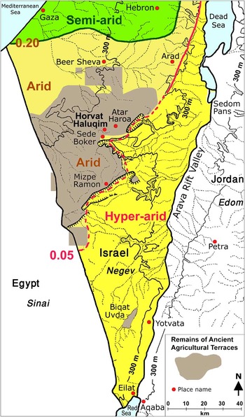
Figure 2 Location map, showing the spatial distribution of ancient runoff-capturing agricultural terraces in the Negev, in relation to the P/PET climatic classification system, after Bruins (Reference Bruins2012: 33). Virtually all terraced wadis are situated in the arid zone. Only very few farming sites based on runoff capture exist in the hyper-arid zone, chiefly the Biqat Uvda Valley (Avner Reference Avner1998).
At Atar Haroa, such excavations were carried out in two casemate rooms of a large oval structure and in three spots of its inner courtyard, as well as in a pillared house (Shahack-Gross and Finkelstein Reference Shahack-Gross and Finkelstein2008, Reference Shahack-Gross and Finkelstein2015; Shahack-Gross et al. Reference Shahack-Gross, Boaretto, Cabanes, Katz and Finkelstein2014). The oval structure, designated as a fortress by Cohen (Reference Cohen1970), has a diameter of 50×42 m and consists of 17 casemate rooms. The latter rooms have a width of 2 to 2.5 m and range in length from 5.5 to 10 m (Cohen and Cohen-Amin Reference Cohen and Cohen-Amin2004: 34–40). The site of Nahal Boqer is dominated by an irregular trapezium-shaped building structure, about 31×9 m, composed of eight casemate rooms surrounding an inner courtyard and also includes a square tower (9×9 m) with several rooms in its northern corner (Cohen and Cohen-Amin Reference Cohen and Cohen-Amin2004: 28–34). The authors excavated in three different casemate rooms within the trapezium-shaped structure, as well as in one spot of the inner courtyard. In addition, they excavated in a pillared house to the south and in a small stone enclosure northeast of the trapezium-shaped structure (Shahack-Gross et al. Reference Shahack-Gross, Boaretto, Cabanes, Katz and Finkelstein2014: 103).
So then, what is the evidence they found in these rooms, courtyards, and enclosure that warrants their conclusion to boldly declare that there was no agriculture in the Negev Highlands during the Iron Age? They found deposits, interpreted as degraded dung. “Phytolith analysis in these dung deposits yielded very low concentrations (mostly below 0.3 million in 1 g of sediment) and phytolith morphotype analysis showed that most phytoliths originate from shrubs and wild grasses” (Shahack-Gross and Finkelstein Reference Shahack-Gross and Finkelstein2015: 257). In our view, this is scant evidence. On the basis of phytolith data in two courtyards and a few rooms, they arrive at the interpretation and extrapolation that there was no agriculture during the Iron Age in an area of 2000 km2! This is, in our view, a classic example how microarchaeology results can lead to erroneous interpretations—erroneous in terms of studied archaeological objects (not agricultural), scale, and applicability extension. In our view, the authors selectively ignore macroarchaeology and microarchaeology obtained by others from ancient agricultural terraced fields in the Negev Highlands, as described below in detail with references.
Investigations of terraced wadis and adjacent archaeological remains in the Negev Highlands by Evenari et al. (1958) and Aharoni et al. (1960), near Mizpe Ramon and Ramat Matred (south of Horvat Haluqim, Figure 2), suggested that stone terrace walls in valleys were used for agriculture during the Iron Age. Also, Cohen (1976) pointed out that Iron Age dwelling remains at Horvat Haluqim (Figure 2) were systematically located along terraced wadis. Thus, he dated the terraced fields on circumstantial evidence to the Iron Age. Haiman (Reference Haiman1994) conducted extensive surveys in the Negev Highlands and found widespread evidence for Iron Age agriculture in the region: (a) an abundance of sickle blades, (b) silos, and (c) threshing floors, all of these in the context of archaeological sites assigned by Haiman (Reference Haiman1994) to Iron Age II.
Agriculture in the Negev desert was not conducted in rooms and building courtyards, but in terraced fields with sufficiently deep loess soils, situated in suitable valleys. Shahack-Gross and Finkelstein did not investigate ancient agricultural fields. Nevertheless, they concluded that terraced wadi fields in the Negev Highlands were not established before Roman times. The oldest terraced fields in the area, according to them, are much younger than the Iron Age (Shahack-Gross and Finkelstein Reference Shahack-Gross and Finkelstein2015: 257): “recent independent evidence based on optically stimulated luminescence (OSL) dating of wadi terraces demonstrates that irrigation systems were not present in the area prior to the late Roman period (Avni et al. Reference Avni, Porat and Avni2012).”
We would refer Shahack-Gross and Finkelstein to the article by Avni et al. (Reference Avni, Porat and Avni2012), to which they refer. The latter authors presented OSL dates from terraced wadis at six locations in the Negev Highlands. The first area mentioned in their article is a terraced field situated near Mizpe Ramon (Figure 1): “A typical terraced plot was trenched using heavy machinery in a tributary of Nahal Zin, approximately 3 km north of Mizpe Ramon. The uppermost loessy layer trapped behind the terrace wall yielded OSL age of 2.9±0.7 ka, which corresponds to the Iron Age” (Avni et al. Reference Avni, Porat and Avni2012: 17). The authors subsequently comment on this result in another section of their article (Avni et al. Reference Avni, Porat and Avni2012: 24): “Therefore, we conclude that sedimentation occurred shortly after the construction of the agricultural installations and that the OSL ages of their infill probably reflects the approximate time of their construction − in this case the Iron Age (ca. 2.9 ka).”
It is true that the measured optically stimulated luminescence (OSL) date is not very precise (standard deviation 700 yr). The real date of the terraced field could range from the Middle Bronze Age to the Hellenistic period. Yet, even the latter period is older than the Roman period, while the highest relative probability of the OSL date is indeed the Iron Age. Therefore, the preceding statement by Shahack-Gross and Finkelstein (Reference Shahack-Gross and Finkelstein2015: 257), based on Avni et al. (Reference Avni, Porat and Avni2012), that wadi terraces were not present in the area prior to the late Roman period, is not correct and in our opinion misleading.
DATING AGRICULTURAL TERRACE LAYERS AT HORVAT HALUQIM WITH 14C
Contextual support for agriculture during the Iron Age is not sufficient. Direct stratigraphic evidence and dating is required from ancient agricultural terraced fields. The first geoarchaeological excavations of terraced wadi fields in the Negev Highlands were undertaken by Bruins (Reference Bruins1986, Reference Bruins1990), who subsequently continued to develop this new approach, particularly at Horvat Haluqim, including macroarchaeology and microarchaeology (Bruins Reference Bruins2007, Reference Bruins2012). These excavations produced Iron Age 14C dates from various layers in agricultural terraces (Bruins and van der Plicht Reference Bruins and van der Plicht2005, 2007; van der Plicht et al. 2009; Bruins et al. Reference Bruins, van der Plicht and Haiman2012). Other periods, particularly the Early Islamic period (Bruins Reference Bruins2012), also exist in terraced fields at Horvat Haluqim, but the Iron Age is most dominant in terms of 14C dating. Small spots of charred soft organic material (COM), as well as animal bone fragments, made 14C dating possible. The latter dating technique is more precise than OSL. In addition, 14C provides direct dating of organic matter.
Shahack-Gross and Finkelstein dismissed our previously published Iron Age 14C dates of ancient agricultural terraces in the Negev Highlands with the following statement: “cases where terraces were dated based on reworked charcoal associated with terrace fill sediments (e.g. Bruins and van der Plicht Reference Bruins and van der Plicht2005) is highly questionable” (Shahack-Gross and Finkelstein Reference Shahack-Gross and Finkelstein2015: 254). The much more comprehensive article by Bruins (Reference Bruins2012) about the agriculture in the Negev during different archaeological periods is not considered by the authors. The article to which they refer presents only two Iron Age 14C dates from an ancient agricultural terrace at Horvat Haluqim. Their statement is again misleading, because one date (GrA-14398, 2860±40 BP) is derived from a bone fragment (sheep or goat), not charcoal, having a 1σ calibrated age of 1087–976 BCE. This bone date belongs to Iron Age I. The other date (GrA-12448, 2590±60 BP) with a calibrated age in the 9th or 8th century BCE (Iron Age II) is indeed designated as charcoal in our article (Bruins and van de Plicht Reference Bruins and van der Plicht2005: 352). However, Shahack-Gross and Finkelstein (Reference Shahack-Gross and Finkelstein2015: 254) label the dated organic material as “reworked charcoal associated with terrace fill sediments,” thereby implying that the charcoal is not in situ or not coeval with the stratigraphic context.
We did not describe the dated material as “reworked charcoal” (Bruins and van de Plicht Reference Bruins and van der Plicht2005). The charcoal in question is a powdery fleck, less than 1 cm in diameter, consisting of soft and fine charred organic particles. We prefer and use the term charred organic material (COM) in later publications, such as Bruins et al. (Reference Bruins, van der Plicht and Haiman2012) for these kinds of powdery charcoal flecks that also appear in archaeological soil layers within small building structures at Horvat Haluqim (Bruins et al. Reference Bruins, van der Plicht and Haiman2012). The powdery fleck in the terraced agricultural field had an irregular shape with diffuse boundaries compared to the surrounding soil matrix. Such a tender fleck without hard solid charcoal fragments cannot have been deposited by alluvial sedimentary fill processes, in view of its shape, fragility and internal organization (entropy). Transportation of such material from upstream by flowing water would have caused disintegration and dispersal. Subsequent sedimentation and concentration of dispersed minute charred particles from flowing water into a distinct fleck with higher entropy than the dispersed constituents is impossible. Only anthropogenic activity, for example shattering kitchen refuse, including ashes and charred organic material, as manure on the field, could have caused the incorporation of such soft charcoal flecks in the particular soil layer within the terraced wadi field, in terms of archaeological site formation processes.
EVIDENCE FOR ANCIENT AGRICULTURAL PRACTICES IN TERRACED WADI FIELDS AT HORVAT HALUQIM DURING THE IRON AGE
The very presence at Horvat Haluqim of terraced fields in three valleys (wadis) constitutes inherent evidence on the macro scale that the builders of the ancient terrace walls did so to conduct agriculture. An unpublished stratigraphic series of 14C dates of Terraced Field 12, Area 5, Section 2004, based on soft charcoal flecks (COM) and animal bones (sheep/goat), is presented in Table 1. The macroarchaeological field setting of Terraced Field 12 and stratigraphic section 2004 (Area 5) are shown in Figures 3 and 4. Erosion has removed the younger upper layers of the stratigraphy in Section 2004, which are still present in Area 3 (Figure 3). The δ13C values show that two dates of charred organic material (COM) are derived from C4 plants. Calibrated dates are given for the highest relative probability range (1σ = 68.2%) and the wider 2σ range (95.4%). The median value of the calibrated age range, available in the OxCal calibration program (Bronk Ramsey Reference Bronk Ramsey2001, Reference Bronk Ramsey2009), is also listed as a concise indicator of the midpoint of the calibrated age range.

Figure 3 Horvat Haluqim, eastern terraced wadi. View of Terrace Wall 12 looking east. The stratigraphic section 2004 (January) in Area 5 is cleaned and prepared for sampling. The arrow indicates the direction of water flow in this partly eroded area.
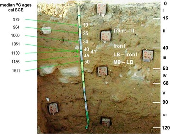
Figure 4 Horvat Haluqim, Terraced Field 12, Area 5, Section 2004 (January). The stratigraphic depth levels of seven 14C dates (Table 1) are shown. The concise median calibrated 14C values are given on the left side and the defined stratigraphic soil layers with depth values are written on the right side. Notice also the position of six undisturbed samples, collected in boxes, for thin section preparation and microarchaeological studies.
Table 1 Radiocarbon dates of Terraced Field 12, Area 5, Section 2004, in the eastern terraced wadi of Horvat Haluqim. Calibrations were carried out with OxCal v 4.1 (Bronk Ramsey Reference Bronk Ramsey2001, Reference Bronk Ramsey2009) using the IntCal13 calibration curve (Reimer et al. Reference Reimer, Bard, Bayliss, Beck, Blackwell, Bronk Ramsey, Buck, Cheng, Edwards, Friedrich, Grootes, Guilderson, Haflidason, Hajdas, Hatté, Heaton, Hoffmann, Hogg, Hughen, Kaiser, Kromer, Manning, Niu, Reimer, Richards, Scott, Southon, Staff, Turney and van der Plicht2013). COM is charred organic material.

The three terraced wadis at Horvat Haluqim are of the first stream order, which means that water flows are rather gentle. Nevertheless, slow aggradation of sediment took place on the terraced fields, as shown by the seven 14C dates, which show a systematic depth-age relationship. Such continuous sedimentation proves that the ancient inhabitants, whether living in tents (like the Bedouin until recently) or in houses, added additional stone courses to Terrace Wall 12, in order to keep the height of the terrace wall above the aggrading soil level of the terraced field. Thus, they ensured the capture of runoff water, critical to conduct agriculture in the desert. Ferric nodules in buried cultivation layers bear witness of this on the microarchaeology level, as described below. The successive sediment/soil layers registered the imprint of human activities on Terraced Field 12 during the Late Bronze and Iron Ages.
Fine and Coarse Pores in Structural Soil Aggregates (Peds)
Modern living roots in these ancient terraced fields are few to very few, ranging from 1 to 50 per dm2. However, the number of fine pores visible on surfaces of structural soil aggregates is much higher, ranging from 100 to 1050 per dm2 (Table 2). The fine pores can safely be interpreted as fossil channels made by roots in the past. Notice in Table 2 that the least number of fine pores (100) occurs in the present surface layer (Area 3, 0–7 cm), which is rather unexpected. Normally most roots and fine pores tend to be present in the surface A horizon of a soil. However, in Terraced Field 12 of the Eastern Wadi at Horvat Haluqim, the largest number of fine pores (1050 per dm2) is present in an ancient cultivation layer, a buried fossil A-horizon, which is darker in color and has a lower bulk density (van Asperen et al. Reference van Asperen, Bor, Sonneveld, Bruins and Lazarovitch2014), due to manuring, as explained below. This layer is dated by 14C to the Late Bronze Age and Iron Age I. The number of 1050 fine pores per dm2 belongs to the highest category (many), according to the international agronomic soil standard of the FAO (2006: 53, Table 63). Hence, abundant ancient root activity has been preserved in the soil aggregates of the darker soil layers, which unmistakably confirms past agricultural crop growth. The fine roots of cereal crops, rather than trees, fit the large quantity of fine pores in the darker soil layers. Indeed, the number of large pores, which may be related to roots from trees or shrubs, is negligible (1 to 2 per dm2).
Table 2 Horvat Haluqim, Eastern Wadi, Terraced Field 12 (Area 3 and Area 1). Data from three soil layers are presented: Munsell color (Munsell 1998), number of fine and large soil pores, phosphorus content, spherulites and phytoliths amounts. Dating is based on 14C.

Macroarchaeological evidence confirming the agricultural production of cereal grains is provided by two ancient silos that were discovered by Bruins and Haiman during archaeological excavations on the lower hillslope adjacent to Terraced Field 12 (to be published elsewhere in detail). One silo contained a flint sickle blade, exhibiting a distinct gloss along its cutting edge, which is evidence of its past usage in the harvesting of cereal crops. The typology of the sickle blade is characteristic for the Iron Age or Bronze Age, according to Steve Rosen (personal communication 2010); see also Rosen (Reference Rosen1997). Hence, the sickle blade matches nicely with the seven 14C dates (Table 1, Figure 4) of the Late Bronze and Iron Ages.
Phosphorus Content of Soil Layers in Terraced Field 12
Due to its excellent preservation in most soils, phosphorus is a very useful chemical element as an indicator of past human activities. Phosphorus is present in excreta from humans and animals, kitchen refuse, and bones. It usually remains tied to its original deposition spot, in terms of spatial and stratigraphic archaeological context, without horizontal and vertical migration (Eidt Reference Eidt1977; Leonardi et al. Reference Leonardi, Miglavacca and Nardi1999). Buried agricultural soils may constitute the sole evidence of past human occupation, particularly in the Negev Highlands, where the number of ancient terraced fields is far larger than the number of housing remains.
Agriculture depletes the soil of phosphorus, due to its uptake by plants and its subsequent removal from the soil by harvesting, for example of cereal crops. Therefore, losses of phosphorus by agricultural production require its replacement by adding manure to the arable land. Indeed, animal dung has been found by microarchaeological studies of buried surface A-horizons in terraced wadi fields at Horvat Haluqim, as described below. The pH of the various soil layers in Terraced Field 12 ranges from 7.3 to 7.9 (Bruins Reference Bruins1986). Under such alkaline conditions, the inorganic phosphorus input from manure reacts with the calcium ions present in the soil, forming insoluble calcium compounds, usually Ca3(PO4)2. There is no lack of calcium, as the largely dust-derived silt-loam loessial soils of the terraced fields contain about 30% calcium carbonate (Bruins Reference Bruins1986).
The amount of phosphorus is clearly highest in the buried ancient cultivation layer (Table 2), which is darker in color. This layer, once a surface A-horizon, now buried here at a depth of 50–57 cm, contains evidence for manuring with kitchen refuse (charred organic material, bone fragments, Negbite pottery, and flint fragments) as well as animal dung. The phosphorus content of the buried cultivation layer (0.55%) is significantly larger as compared to the present surface A-horizon (0.23%). This is remarkable, given the fact that Bedouin herds graze the vegetation at Horvat Haluqim in modern times, particularly during February and March, when green pasture reaches its annual peak. Obviously, the sheep and goats of the Bedouin disperse some urine and dung on the present surface of the ancient agricultural terraced fields at Horvat Haluqim while they are grazing. Nevertheless, the buried darker layer, dated by 14C to about 1300–1000 cal BCE, has a higher content of phosphorus. The deepest soil layer (143–150 cm) predates the beginning of human agricultural activities and has by far the lowest phosphorus content (0.14%).
MICROARCHAEOLOGICAL EVIDENCE FOR RUNOFF-CAPTURING AGRICULTURE AT HORVAT HALUQIM
Ferric Nodules
Large-size thin sections were made of undisturbed samples (Figure 4) of stratigraphic layers in ancient agricultural terraced fields at Horvat Haluqim. Ferric nodules (Figure 5) in ancient soil layers of terraced fields constitute outstanding microarchaeological evidence, proving the past practice of runoff-capturing for agriculture at the site. Such concentrations of iron-(hydro)oxides, which overprint the existing soil matrix and its constituents, i.e. postsedimentary soil development, can only develop under an alternating wet-dry reduction-oxidation regime, which is abnormal for free-draining aridic desert soils without a groundwater table (Bruins Reference Bruins1986; Bruins and Jongmans Reference Bruins and Jongmans2012).

Figure 5 Terraced Field 12, Area 5, Section 2004, Layer II-Ah, thin section 04075, 25–32 cm (XPL view). Orthic ferric nodule, indicated by arrows, overprinting the soil matrix. Notice also black charred organic particles. Scale bar 100 micron=0.1 mm. This layer was dated by 14C to the Iron Age (Figure 4).
The building of terrace walls to enable agriculture caused flooding of the terraced fields (Figure 1) that lasted for a few days following significant rains. Part of the soil became saturated with water, which led to the disappearance of air (oxygen). The resulting reduction regime in the soil facilitated iron to become mobile and concentrate in certain sinks, where nodules could form. After the water drained away, the air would return to the soil, oxidizing the iron and “freezing” it in place (van Breemen Reference van Breemen1986). Therefore, the presence of ferric nodules in the Iron Age soil layers of ancient agricultural terraced fields at Horvat Haluqim is convincing evidence that these terraced fields captured runoff water in the past, because they were being used for agricultural production. The included example of a ferric nodule (Figure 5) is from a layer 14C dated (1016–922 cal BCE, 1σ) to the Iron Age (Table 1).
Such ferric nodules do not occur in free-draining desert soils in first-order stream valleys without terrace walls. Indeed, even in the uppermost soil layer of Terraced Field 12, dating to the last 1000 yr (Area 3, 0–7 cm), such ferric nodules do not occur. The last farmers abandoned the area in the course of the Early Islamic period (Bruins Reference Bruins2012), and, as a result, the terrace walls were not retained above the level of the aggrading soil surface. Therefore, the amount of captured runoff diminished significantly and, as a result, ferric nodules were not formed in this upper layer.
Ancient Manuring of Terraced Agricultural Fields at Horvat Haluqim
The stratigraphic layers in Terraced Field 12 of the eastern wadi at Horvat Haluqim, related to ancient agriculture in different periods (Bruins Reference Bruins2012), often have a somewhat darker color and a lower bulk density (van Asperen et al. Reference van Asperen, Bor, Sonneveld, Bruins and Lazarovitch2014). These soils are somewhat reminiscent of the Terra Preta agricultural soils in South America (Lehman et al. Reference Lehmann, Pereira da Silva, Steiner, Nehls, Zech and Glaser2003), although the charcoal content in the latter soils is significantly higher, as much more vegetation is available here in the wet tropical forests. Nevertheless, also in the Terra Preta soils, the charcoal sizes include many fine particles of less than 20 μm (Glaser et al. Reference Glaser, Balashov, Haumaier, Guggenberger and Zech2000), which is also common in the darker agricultural terrace soil layers at Horvat Haluqim (Bruins and Jongmans Reference Bruins and Jongmans2012). The presence of very fine charcoal particles, small bone fragments, ceramic sherds, and pieces of worked flint has been interpreted by Bruins (Reference Bruins2007) as evidence for manuring with kitchen refuse from cooking fires. Animal bones and ash with charred organic material have been used since time immemorial by people to increase the soil fertility of agricultural fields (Miller and Gleason Reference Miller and Gleason1997). Experimental archaeology, using kitchen ash refuse from Bedouin cooking fires, indeed showed a beneficial effect on the growing of wheat (van Asperen et al. Reference van Asperen, Bor, Sonneveld, Bruins and Lazarovitch2014).
In addition, another source of manure, animal dung, has also been found in microarchaeological studies (Figure 6) of soil layers in ancient terraced wadi fields at Horvat Haluqim (Bruins and Jongmans Reference Bruins and Jongmans2012). The lower bulk density of darker colored cultivation layers is apparently caused by addition of both kitchen refuse and animal dung, through time, to the aggrading soil surface of the terraced field. The presence of animal dung is also substantiated by the large numbers of spherulites (Table 2) found in darker colored ancient cultivation layers at Horvat Haluqim, as presented below in more detail.

Figure 6 Terraced Field 12, Area 5, Section 2004, Layer II-Ah, thin section 04075, 25–32 cm. Large unburned dung fragment (PPL). Scale bar 500 micron=0.5 mm. This layer was dated by 14C to the Iron Age (Figure 4).
Spherulites and Phytoliths
Spherulites are very small spheres of calcium carbonate, usually in the range of 5 to 25 micron (Canti Reference Canti1998), i.e. the size of fine silt. They have a high birefringence under the petrographic microscope, showing a very distinct extinction cross, as seen in crossed polarized light (XPL), shown in Figure 7. The structure of spherulites represents biomineralization, as they are formed in the intestines of herbivores such as sheep, goat, and cattle (Canti Reference Canti1998). Such fecal spherulites, therefore, can be an indicator in agricultural soils of manuring practices.

Figure 7 Terraced Field 12, Area 5, Section 2004, Layer II-Ah, thin section 04075, 25–32 cm. Multitudes of small carbonate spherulites, characteristic microconstituents of dung, show the characteristic cross-shaped extinction pattern (XPL view). Scale bar 50 micron=0.05 mm. This layer was 14C dated to the Iron Age (Figure 4).
Three soil samples of selected stratigraphic layers in Terraced Field 12 were analyzed quantitatively for spherulites and phytoliths by Rosa M Albert in the Laboratory of the Department of Prehistory, Ancient History and Archaeology (University of Barcelona). Extraction and analysis methodologies are described in Albert and Weiner (Reference Albert and Weiner2001), Canti (Reference Canti1998), as well as in Portillo and Albert (Reference Portillo and Albert2011). Quantitative results of the spherulites and phytoliths of the three samples (R M Albert, personal communication 2003) are presented in Table 2. The number of spherulites per gram soil is very high (7.017.544) in the buried Late Bronze to Iron Age I cultivation layer, characterized by ferric nodules, charred organic particles, bone fragments, non-burned dung fragments, Negbite sherds, and worked flint fragments. The present soil surface layer contains only 566.038 spherulites per gram soil, while the preagricultural layer, at a depth of 143–150 cm, contains the lowest number of spherulites: 162.791. Obviously, the sheep and goats of the Bedouin disperse some dung on the present surface of the ancient agricultural terraced fields at Horvat Haluqim, while they are grazing. However, the number of spherulites in the buried ancient cultivation layer is 12 times larger than in the present surface layer, notwithstanding the seasonal grazing. Finally, the spherulite/phytolith ratio of the three different soil layers (Table 2) shows there is not a linear relationship between the number of spherulites and phytoliths.
DISCUSSION AND CONCLUSIONS
A review article by Shillito (Reference Shillito2013), entitled “Grains of truth or transparent blindfolds?” calls for caution in the use of phytoliths in archaeological research. Concerning the Negev Desert, hardly anything is known about phytolith transport by dust, in both quantitative and qualitative terms. Already in the 19th century, Darwin (Reference Darwin1846) identified phytoliths in “fine dust which often falls on vessels in the Atlantic Ocean.” Likewise, it seems reasonable to assume that phytoliths of hillslope shrub vegetation may be moved by wind and by runoff from hilly catchments to building remains and ancient agricultural terraces. Moreover, phytoliths can also be leached from their original soil level to deeper soil strata (Fishkis et al. Reference Fishkis, Ingwersen, Lamers, Denysenko and Streck2010). Shillito (Reference Shillito2013: 79) states regarding phytoliths: “Researchers need to be more realistic over what can and cannot be concluded on the basis of the data, and to avoid over-interpretation.”
Indeed, the theory developed by Shahack-Gross and Finkelstein (Reference Shahack-Gross and Finkelstein2008, Reference Shahack-Gross and Finkelstein2015) that there was no agriculture in the Negev Highlands during the Iron Age, based on phytolith composition in material interpreted as degraded dung, is a classic example of microarchaeological overinterpretation in our opinion. The phytoliths data are from rooms and courtyards, not used for farming. Phytoliths composition is supposed to prove that domesticated animals (sheep, goats) did not eat agricultural products. Yet grasses were also found to be present among the phytoliths in the degraded dung. Distinction between phytoliths derived from wild grasses or from agricultural grasses (barley, wheat) is a very problematic issue. In terms of comparative anthropology, there are periods during the year when domesticated animals in the Negev graze mainly wild vegetation. Fieldwork in the Negev during the period 1977–1983 by Ben-David (Reference Ben-David1982) showed that some Bedouin tribes in the region, the Jahalin and Janabib, relied for their herds on free grazing of wild vegetation throughout the year without the use of stubble and fodder from agricultural crops. Therefore, even if the material found in the studied rooms and courtyards is degraded dung and the dung lacks wheat or barley phytoliths (which cannot be proven), it is extremely farfetched to conclude on this basis the absence of farming in an area of 2000 km2 during the Iron Age, a period that lasted about 700 yr (~1200–500 BCE).
In this rejoinder, we presented new data of anthrosols in ancient agricultural terraced fields at Horvat Haluqim, situated near Atar Haroa in the Negev Highlands (Figure 2). First and foremost, a series of seven stratified 14C dates shows this ancient cultivation layer to have a systematic depth-age relationship ranging from the Late Bronze Age to the Iron Age. Microarchaeological investigations of these buried anthrosols revealed evidence of ancient runoff water capturing in the form of ferric nodules, developed in situ. Anthropogenic additions present in these anthrosols are kitchen refuse and animal dung, interpreted as evidence for ancient manuring. Quantitative investigations of fecal spherulites in selected soil layers of Terraced Field 12 revealed very high quantities in these buried anthrosols (Table 2), which also contain significantly more phosphorus than the pre- and post-agricultural soil layers. All macroarchaeological and microarchaeological characteristics can only be interpreted as direct evidence for the practice of runoff-capturing agriculture during the Late Bronze and Iron Age at the site of Horvat Haluqim in the Negev Highlands.
Acknowledgments
We are grateful to the technical staff at the Centre for Isotope Research (University of Groningen) for pretreatment of the organic samples and AMS 14C dating. The contribution to part of the fieldwork and micromorphological studies by Dr A Jongmans (formerly Wageningen University) is acknowledged. We thank the referees for critical comments that substantially improved the composition of the article.


