


INTRODUCTION
Since 2003, we have operated a dating system in the Institut Francophone d’Afrique Noire (IFAN) Radiocarbon Laboratory in Dakar (Senegal). Some results have previously been obtained at sites such as Khant in northern Senegal, discovered by A Ravisé in 1969 (Ravisé Reference Ravisé1975). These results have allowed the study of chronological sequence of a small entropic valley in this zone called Bolé (Ndeye et al. Reference Ndeye, Sène and Diallo2011). Results were also obtained at Mauritanian sites and have made it possible to date the consumption of shellfish in order to determine the Nouakchottan transgression (Vernet Reference Vernet and Krzyzaniak1993). Beta counting was carried out using a Tri-Carb® 3170TR/SL liquid scintillation analyzer from Packard provided with BGO (Bi4Ge3012) tubes driven by the Quanta Smart software under a Windows XP operating system. In “super low level” mode, the background noise (0.1 cpm) is very low (Cook et al. Reference Cook, Hold, Naysmith and Anderson1990). Performance assessment of the dating system (background and factor of merit) is done using the known samples from Université de Paris VI and standards from the International Atomic Energy Agency (IAEA). In the 13–85 kV energy range at an efficiency of 68% and a background of 0.2 cpm, the figure of merit is 23.4. Physical and chemical pretreatments depend on the nature of the samples, but the classic acid-base acid (ABA) procedure is usually adopted. The acid treatment is done with 8%HCL, and the base with 5% NaOH. The liquid scintillation counter uses benzene as a scintillation solvent. For each sample, 2 g of benzene was placed in a standard (20 mL) pico glass vial. The scintillators employed were a bis MSB+ Butyl PBD mixture (6 mg + 6 mg) (Horrocks Reference Horrocks1974). Radiocarbon (14C) age calculations are based on the Libby half-life of 5568 yr and dates are expressed in yr BP with AD 1950 as the reference year. Ages and standard deviations (2σ) of samples are adjusted for stable isotope fractionation to a normalized concentration ratio (δ13C = –25%), according to Stuiver and Polach (Reference Stuiver and Polach1977).
Most of the 14C dates were obtained on charcoal samples and mollusk samples and tree leaves were taken from different archaeological sites but also from environmental sites. In the list that follows, new dates are given along with their location coordinates, the description or caracteristic of the samples, and the corresponding calibration. The calibration program used is Calib 7.4.0; Stuiver et al. Reference Stuiver, Reimer and Reimer2021). In this work, we present results from dating studies from sites in Senegal, Mali, and Togo. Comments on the 14C dates explain the results in relation to different archeological or environmental issues.
ENVIRONMENTAL SAMPLES
Dakar Region Series
Description of the Site
The study area is situated in the region of Presquʼîle du Cap Vert (Figure 1), a heavily urban and densely populated part of Dakar that is 550 km2 in area. Dakar (14º40ʼ20"N, 17º25ʼ54"W is the capital city of Senegal with a population of about 3.5 million people and a density of 4646 inhabitants/m2.

Figure 1 Map of the Dakar region showing the sample collection sites and the industries (from Ndeye et al. Reference Ndeye, Sene, Diop and Saliège2017).
References
As part of an investigation of annual changes in atmospheric CO2 pollution, 14C analyses on the leaves of trees collected in the Dakar region (Figure 1) by botanists of the IFAN and the Faculty of Science of the University Cheikh Anta Diop of Dakar were made. This involves calculating Δ14C from the post-bomb ages and comparing it with a reference site Δ14C (Table 1) (Schauinsland station as background). We can thus determine the excess CO2 (fossil) which has been added to the natural component of atmospheric CO2 (Suess Reference Suess1955). The following samples were analyzed to determine Δ14C (Stuiver and Polach Reference Stuiver and Polach1977; Mook and van der Plicht Reference Mook and van der Plicht1999) and time variation for the Dakar region. The samples were collected and processed by the Marine Biology Laboratory of IFAN and finally analyzed by the IFAN radiocarbon laboratory.
Table 1 Radiocarbon results of environmental samples (tree leaves) for the Dakar region.
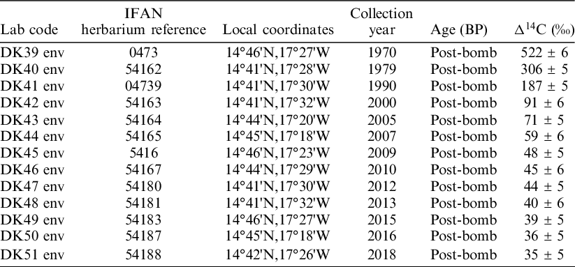
As the samples were collected from 1970 to 2018, Δ14C is calculated by using the conventional notation correcting the age at collection time, for samples collected after AD 1950: Δ14C = 1000*(F.eλ(t-1950) –1), where λ is the decay constant 1.209 × 10⁻⁴ based on the half-life of 5730 yr, t is the time of collection, and F is the fraction of modern carbon measured (Donahue et al. Reference Donahue, Linick and Jull1990).
Comments
Δ14C measurements in tree leaves collected from the urban area of Dakar from 1970 to 2018 are systematically lower than values measured in Schauinsland (Levin and Kromer Reference Levin and Kromer2004) which is due to anthropogenic CO2 emissions from fossil fuel. These measurements show the existence of the local Suess effect due to the anthropic action. Using 14C as a tracer, we can determine the fossil CO2 concentrations by means of the equations of the carbon mass balance. The local Suess effect can then be indirectly estimated using a mathematical model (Oeschger et al. Reference Oeschger, Siegenthaler, Schotter and Gugelmann1975).
ARCHEOLOGICAL SAMPLES
Mali Series
Description of the Sites
The three sites surveyed are located in the Mopti region (14º29ʼ54"N, 3º11ʼ09"W), which is Mali’s fifth administrative region (Figure 2). It covers 79,017 km2. The first site is NGaissi located in chief place of circle, a commune called Douentza whose geographical coordinates are: (15º00ʼ17.10ʼN; 2º57ʼ18.22ʼW) for an elevation of 298 m and 4.72 km of altitude. The second site is Lekeduru is located in the municipality of Madougou, which is the capital of the municipality and whose geographical coordinates are 14º30ʼ23.01"N, 3º03ʼ17.35"W at an elevation of 282 m and altitude of 2.4 km. The third site is that of Lakeduna located in the village of Mali called Somadougou whose geographical coordinates are 14º17ʼ06.42"N; 4º03ʼ47.48"W at an elevation of 273 m and altitude of 1.33 km.

Figure 2 Map of the region of Mali showing the sample collection sites (in blue and red). Please see electronic version for color figures.
References
The topic of this sample collection work is the study of the people and plants of the inner delta of Niger and its refuge areas from the early occupation to the sub-current period. The objective of this dating is to highlight the human occupation in these sites of Mali (Ladekuna 4 m depth), Lèkèduru (3 m depth), and NGaissa (2 m depth) and see from the plants the geographical space that was built. These charcoal samples were collected and submitted by Professor Ali Diabiguilé of the Archaeology Department at the University of Bamako.
Comments
From the calibrated dates in Lekeduru (Table 2), the occupation stretches from the second half of the Iron Age [cal BC 404: cal BC 54] to the time of the great medieval empires of Western Sudan ([cal AD 1282: cal AD 1432]). Thus, it begins, according to the sample collected DK56, in cal BC 404 and ends in cal AD 1432. Meanwhile, the site was abandoned until the 2nd century AD or cal AD 123. This occupation continued until the 5th century (cal AD 433). A long period of hiatus followed from the 5th to the 12th century. This phase corresponds to a period of unrest, marked in Senegal and Western Sudan by raids, wars of succession, and the development of trans-Saharan trade, which reached its peak between the 13th and 14th centuries (Niane Reference Niane1975). However, the most salient fact is the transition between the Iron Age and the birth of the great medieval kingdoms whose advent provoked wars of vassalization successions of the small kingdoms by Ghana and especially the empire of Mali from the thirteenth century [cal AD 282: cal AD 1432]. Lekeduru in its upper terminal, is contemporary of the site of Djenné, of Songhai. In addition, these dates are contemporaneous of the heyday of medieval empires and slip into the chronology of African protohistory, according to the division of Historians. On the other hand, NGaissa’s site is of Neolithic age according to the DK58 sample. This occupation begins in the 6th millennium BC, so it extends from [cal BC 5797: cal BC 5606]. These dates belong to the first phases of the Neolithic in West Africa, it is the ancient Neolithic. Subsequently, the NGaissa site was abandoned over a long period of time. This hiatus lasted from cal BC 5606 to cal BC 1397, an abandonment time of more than two millennia. This reoccupation (DK55) [cal BC 1397: cal BC 996], corresponds in a large interval to the early beginnings of the iron age. This late reoccupation of the site is followed by 633 years of abandonment (cal AD 764), based on the lower bounds. From there, NGaissa is no longer populated, and its late repopulation coincides with the birth of the empire of Ghana (DK54), upper bound (cal AD 1018).
Table 2 Radiocarbon results of charcoal samples for Mali sites.
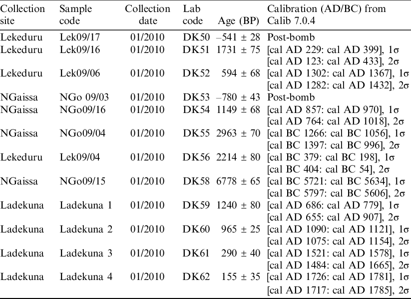
From these dates, we can read, a priori, the impact of the geopolitical situation of Mali in archaeological sites. In this sense, the formation of the Ladekuna site was occupied from the 7th century AD. This occupation is contemporary with the phase of abandonment of the NGaissa site (DK54) as well as the premises of Mali and the decline of Ghana. Ladekuna thus fits into this “medieval chronology” marked by sequences of disturbances, of chronological hiatus in the dynamics of settlement. Therefore, the chronological range 11th–15th century (DK59, upper bound, DK60, DK61, lower bound) is contemporary with the domination of trans-Saharan trade and the Mandingo empire of Mali and its heyday. From these dates, we can read, a priori, the impact of the geopolitical situation of Mali in archaeological sites. In this sense, the formation of the Ladekuna site was occupied from the 7th century AD. This occupation is contemporary with the phase of abandonment of the NGaissa site (DK54) as well as the premises of Mali and the decline of Ghana. Ladekuna thus fits into this “medieval chronology” marked by sequences of disturbances, of chronological hiatus in the dynamics of settlement. Therefore, the chronological range 11th–15th century (DK59, upper bound, DK60, DK61, lower bound) is contemporary with the domination of trans-Saharan trade and the Mandingo empire of Mali and its heyday. The period cal AD 1665 [cal AD 1717: cal AD 1785] resulted in the decline of trans-Saharan trade and the rise of the Atlantic Trade. This period saw the Islamization of West Africa (Guigou Reference Guigou1985), which resulted in periods of instability from the 12th to the 14th century. The resumption of occupation, therefore of settlement, will take place with the “birth” and domination of transatlantic trade and the fall or even the end of the era of traditional kingdoms in Africa. Thus, the chronological range [cal AD 1717: cal AD 1785] is significant of the impact of Atlantic trafficking disorders.
Togo Series (Greniers du Niok, Togo)
Description of the Site
The attics of the Niok caves of Togo, located at 10°39,613ʼN; 0°8,836ʼE in the Savanes region, and more precisely in the Prefecture of Tandjouaré, are about 30 km from the city of Dapaong. They are high cliffs, whose walls are oriented to the north, dominating from their peak the savanna of this northern part of Togo. These are the last high reliefs before this immense expanse of savanna that extends to Burkina Faso. This formation presents cliffs of Proterozoic age higher at the base an alternation of pellites (argilites) and psammites, the whole resting on a crystalline base dated from the Birrimian. Horizontal crevices open at the top quarter of their height; with difficult access, they have served, for a very long time, as shelter and refuge for the indigenous populations during the periods of various insecurities that prevailed in the region from the 17th to the 19th century. The granaries, cut in the same traditional architectural style from local materials (stone, clay, and straw) contained the crops and the caves provided a refuge for threatened populations. (According to the UN: https://whc.unesco.org/en/indexlists/1504/.)
References
These samples of coals were collected between 2010 and 2012 from the Niok site and submitted by Dr Angéle Dola, AGUIGAH archaeologist at the University of Lomé-Togo. The objective is to determine the chronology of occupation of the site Grenier des Grottes du Noik by the indigenous populations during the periods of various insecurities.
Comments
Of all the BP dates, the samples analyzed place the chronology of occupation between the 6th and 16th century AD (cf.DK65) (Table 3). Thus, the occupation is older in Nok Laré (Dak68). But these calibrated samples place the dynamics of the stand in the 4th–15th century sequence. Consequently, the occupation at Matema began in the 4th century (cal AD 381) and continued until the 6th century (cal AD 561). This corresponds to the early years of medieval African civilizations whose beginning start from the 15th century (cal AD1442) according to the nomenclature of the division of history (Niane Reference Niane1975). In addition, the Pimini and Nok Lare sites (DK63 and DK68) will be occupied only after the abandonment of the Matema site (Dk65). These two sites share a timeline stretching from cal AD 1292 to cal AD 1442. Therefore, the range [cal AD 1394: cal AD 1442] includes that of DK63 [cal AD 1292: cal AD 1401], proof of contemporaneity over a long period of both dates, even if the occupation continued at Nok Laré (more than 41 years).
Table 3 Radiocarbon results of charcoal samples for Togo sites.

From all the dates (BP), the samples analyzed place the chronology of occupation between the 6th and 16th centuries AD (DK65). Thus, the occupation is older in Nok Laré, level 5 (Dak68). But these calibrated samples rejuvenate the BP dates and situate the population dynamics in the 4th–15th century sequence. As a result, the occupation at Matema begins in the 4th century [cal AD 381: cal AD 561], the first years of African medieval civilizations, according to the nomenclature of the division of history and is determined at the beginning of the modern era (15th century), cal AD 1442. In addition, if the sigma 1 and 2 ranges of Dk65 are contemporary in their intervals, DK68 and Dk63 will be occupied only after the abandonment of the Matema site. These two samples share a time frame stretching from ca1 AD 292 to cal AD 1442. Therefore, the range [cal AD 1394: cal AD 1442] includes that of DK63 [cal AD 1292: cal AD 1401], proof of contemporaneity over a long period of both dates, even if the occupation continued at Nok Laré (more than 41 years).
Casamance (Ziguinchor at the South of Senegal) Series: Djibonker-Ananboré
Description of the Site
Djibonker is a village in Senegal located in Basse Casamance (12°32ʼ00"N, 16°21ʼ00"W) and at an altitude 33 m in the south of Senegal. It is part of the rural community of Enampore, in the district of Nyassia, the department of Ziguinchor, and the region of Ziguinchor.
References
The dating on this part of southern Senegal aims to determine the presence of the Baynounk ethnic group, which is supposed to be the first in Djibonker and Ananboré. However, archaeological research dates the Baynounk presence around the 7th century. Phase II (cal AD 200: cal AD 700) of the region’s only established chronology coincides with the introduction of shellfish harvesting and irrigated rice cultivation,) from the land gained on the mangrove (De Sapir Reference De Sapir1971). These recent archaeological excavations (2011–2012) werecarried out on former habitat sites (Djibonker and Butimul) and attest to an old presence of Baynounk in the west, between 683 BP and 1539 BP the corresponding calibrated age are [cal AD 1277: cal AD 1300] to [cal AD 429: cal AD 494]. These charcoal samples were collected in 2011 and submitted in 2012 by Professor Moustapha Sall of the Department of Archaeology at Cheikh Anta Diop University of Dakar (Senegal).
Comments
Radiocarbon results based on coal samples indicate that the occupation process at Djibonker/Enamboré begins in 735 ± 30 BP and ends in 1664 ± 30 BP (Table 4). The calibration of the DK64 sample gives a range of cal AD 311 to cal AD 433 and thus marks the birth of the occupation and, a priori, the beginning of the population dynamics of the Baynouk community in Ziguinchor. The proven human occupation dynamic is located at the beginning of Protohistory, between the 4th and 10th century AD. Beyond that, the hiatus between DK64 and DK63 results in a period of vacancy of more than 9 centuries. On the other hand, DK62 and DK63 are contemporary, moreover the upper limit of DK63 [cal AD1268] is inserted in the chronological range of [cal AD 1240: cal AD 1294]. Therefore, the occupation Djibonker/Enamboré was made in two phases 7th–8th century AD, long period of hiatus (9th–11th century) and reoccupation 12th–13th century, epoch corresponding to the peak of the medieval kingdoms of Senegalese and trans-Saharan trade (Bâ Reference Bâ2002).
Table 4 Radiocarbon results of charcoal samples of Ziguinchor (south Senegal) sites.

The Delta of Saloum (Sénégal) Series
Description
The 3 sites (Guior, Dionewar, Fedial/Joal) that were excavated are part of the Saloum delta (13°44ʼ01"N, 16°41ʼ48"W), which has three main branches (Figure 3): the Saloum in the north (110 km), the Diombos (30 km) and the Bandila in the south (18 km). These branches are joined by numerous small channels locally called “Bolons.” This creates many islands that are bordered by dense mangrove and comprise three ecological zones: maritime, amphibious, and continental. The delta comprises an area of around 500,000 ha and is inhabited by human communities that have been involved in maritime activities for well over two millennia (Camara et al. Reference Camara, Hardy, Dioh, Gueye, Piqué, Carrée, Sall and Diouf2017). These include the exploitation of shellfish including the bivalves oyster, Crassostrea gasar, and cockle (Arca senilis) as well as the gastropods (Cymbium spp.), all of which proliferate in the Delta. Artificial shell mounds comprising bivalves and gastropods provide evidence for a human presence in the Delta for well over 2000 years.
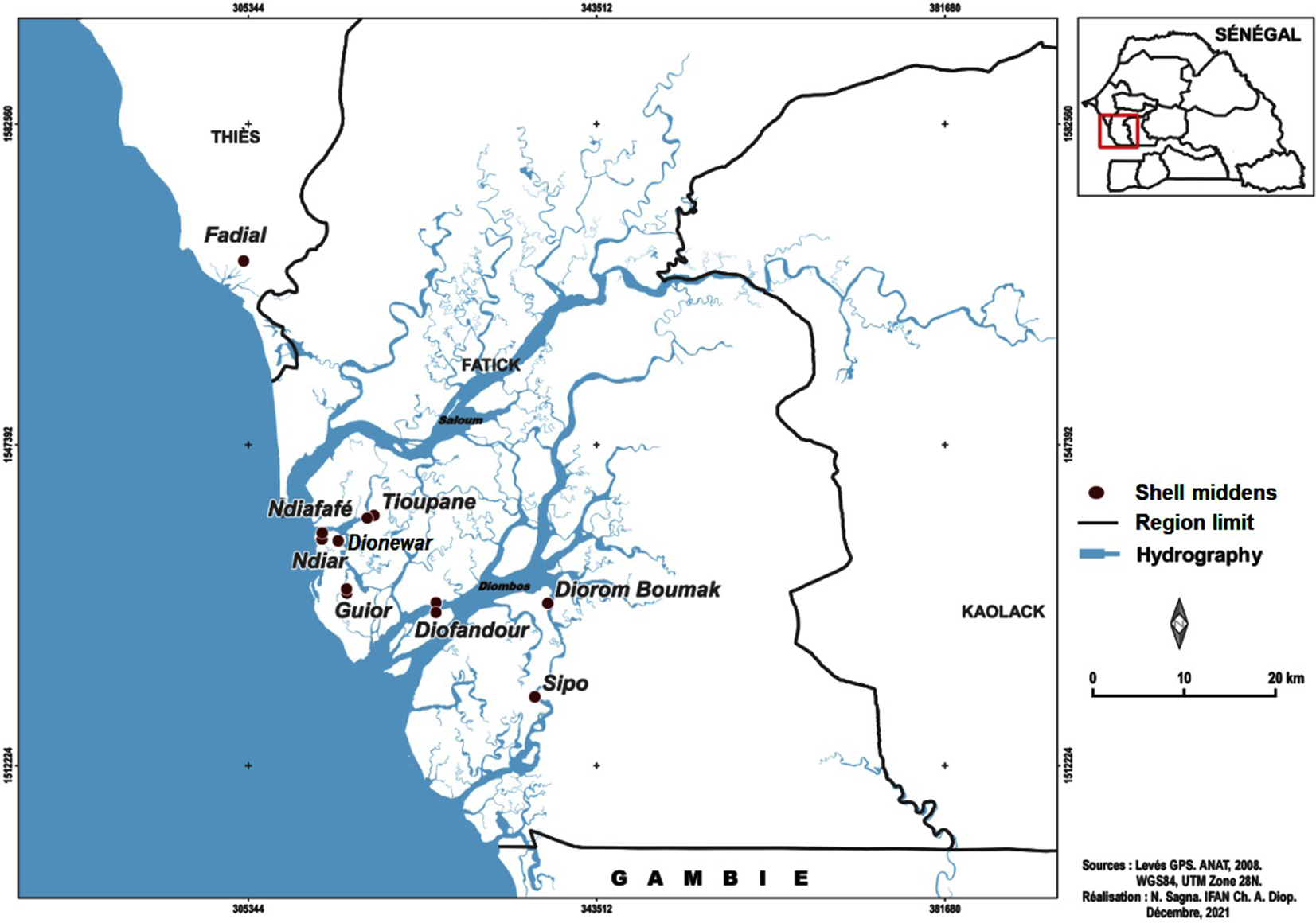
Figure 3 Location map of shell middens region in the Saloum delta (Camara et al. Reference Camara, Hardy, Dioh, Gueye, Piqué, Carrée, Sall and Diouf2017).
References
The exploitation of mollusks by the populations of the Saloum Delta (13°44ʼ01"N, 16°41ʼ48"W) dates back more than 2000 years. Thousands of shell mounds testify to the very important activity of fishers and the riparian populations and thus become archaeological remains. These consumer remains were reused for the construction of several necropolises as burial mounds by fishers. Research has been carried out by IFAN CH.A.Diop researchers since 2010. The interests of this research are multiple for archaeological, paleoclimatic, archaeozoological, and malacological information. Samples of mollusks (Anadara senilis) were collected at various sites in the Saloum delta of Senegal (Dionewar, Guior, and Fedial/Joal). They were submitted in 2010 by Prof Abdoulaye Camara of the Archaeology Laboratory of IFAN CH.Diop of Cheikh Anta Diop University. As all the sample are marine organisms, the calibration has been done taking in account the reservoir effect ΔR = 12 ± 46 BP (Stuiver et al. Reference Stuiver, Reimer and Reimer2021).
Comments
Radiocarbon dates obtained from Anadara Senilis samples collected from Saloum Delta sites indicate that population dynamics began at Fedial/Joal in the Early Neolithic (8726 ± 180 BP) and [cal BC 7937: cal BC 6946] (Table 5). This means that the occupation in the Senegalese West, after Tiémassas (Descamps Reference Descamps1979), had continued at this location in this interval of time. Only the sample collected from the surface raises the question of the archaeological context of the discovered material. Then, in the Saloum Delta, the trace of human settlement is found, in the “Middle Neolithic Age BP,” at Dionewar, but, calibrated, at the early age of iron metallurgy in Senegal ([cal BC 473: cal BC 124]; McIntosh and Bocoum Reference McIntosh and Bocoum2000). The dates obtained in the Saloum Delta are part of the regional ensemble, which puts the occupation between the 5th and the 16th century AD. Thus, after Joal, the populations occupied Dionewar then Guior, whose calibrated ages are contemporary because DK47 is in the interval of more recent DK46 occupation (cf. Table 5).
Table 5 Radiocarbon results of shell samples (Anadara senilis) for the Delta of Saloum (Sine Saloum-Senegal) sites.

Mako (Eastern Senegal, Kedougou Region) Series
Description
Mako is an archaeological site in eastern Senegal. This occupation, established on the flanks of a hill at 600 m in altitude, presents as a set of accumulation scattered on this promontory. Sediment development levels are relatively low, so open boreholes rarely exceed 50 cm deep. However, they delivered an abundant material culture: pottery with conical bottoms, carnelian beads, and copper objects. This material culture bears witness to an occupation dating back to the late Iron Age, hence the connections with the trans-Saharan trading caravan cities it reveals
References
The charcoal samples were supplied as part of a program relating to iron metallurgy in Senegal. This is particularly the case of eastern Senegal, a region that was marginalized by research into the iron and steel industry. Thus, the chronological indications available on the iron phenomenon are still very small, hence this initial aimed at multiplying the dating. Indeed, they are the only ones who can situate the techniques in their contexts in order to envisage the dynamism that binds the productions in this region. The general chronology framework of the region extending between 400 BC and 1950 AD is a set of hiatuses preventing the possibilities of rigorous interpretation of the distribution of techniques and old metallurgy in time and space. These coal samples were collected from the site called Mako in the eastern part of Senegal. They were submitted in 2020 by Mr Athié of the Archaeology Laboratory of IFAN CH.A.Diop.
Comments
The occupation stretches from 1650 ± 46 BP to 1245 ± 40 BP or from the 13th to the 17th century, such a sequence corresponds to the domination of the medieval kingdoms of the Senegalese, example the Gabou (Barry Reference Barry1988) (Table 6). But these calibrated dates with the stratigraphic context (level 4, for example), the occupation goes from the 4th to the beginning of the 6th century (DK52, [cal AD 321: cal AD 538]). Then, the site of “Mako” is abandoned from cal AD 538 to cal AD 641. The reoccupation, certified by the different samples obtained in different soundings, takes place everywhere, from this date, in the seventh century and ends in the eighth century. This age range confirms the “sayings” of written documents on the question of settlement and royalty in the vicinity of the southern rivers.
Table 6 Radiocarbon results of charcoal samples for Mako (eastern Senegal) sites.

Hombo (Senegal River Valley) Series
Description
The Hombo site is located on the silty plain of Jeeri, which is rugged by ravines and sandy-clay plateaus. It is surrounded by lateral outcrops (in the west and north) and dune formations (in the east and south). Further, towards the surroundings of Sincu Garba, Galayabé and Ourossogui, a belt of lateral hills surrounds the entire area. The site itself is a mound 800 m east of the village of Hombo. This hill, formed by a slight median prominence, is eroded at the margins. The mound is not as large as that, it is only 360 m long, 200 m wide, and 3 m thick. Its surface is not completely invaded by erosions due to subactual sandy deposits protecting it. The middle part, the most prominent point of the hill, is the only one without it, it is thus characterized by a silty crust infested by blocks of terracotta, fragment of pottery and ruin related to iron metallurgy.
References
In this site called Hombo, the chronology requested falls within the framework of the problem on the settlements of the middle valley of the river Senegal. Between the occupations of waalo and jeeri there are supposed to be chronological differences. The dating on the Hombo sites could confirm the anteriority of the populations between these two large geographical entities. In addition, the dates were intended to help understand the evolution of the production mainly of iron metallurgy within the habitat (Bocoum et al. Reference Bocoum, McIntosh and McIntosh1992). These coal samples were collected at the site and submitted in 2020 by Mr Atjhié of the Archaeology Laboratory of IFAN CH.Diop de Cheikh Anta diop University.
Comments
Hombo, a village in northern Senegal, has been populated since the end of the Neolithic period (DK69, cal BC 1129) (Table 7). On the basis of the calibration and in its upper terminal, DK67 is prior to DK69. On the other hand, DK58 (904 ± 20 BP) undergoes aging after calibration [cal AD 1040: cal AD 1109]. The occupation process in Hombo is “homogeneous” to a large extent. Indeed, if DK69 and 67 are witnesses of the beginning of the occupation of Hombo, the other samples are contemporary, according to the upper and lower bounds of the interval of their calibrations. Therefore, three phases of space occupancy are legible in Hombo: cal BC 1128–cal BC 167, this sequence is followed by a period of hiatus of cal AD 92 to cal AD 538. Thus, an abandonment that is probably linked to the degradation of the Ferlo ecology with the “leak” of the isohyetes. Then there is the reoccupation of the region from cal AD 538 to cal AD 887, upper bounds, that is from the 6th to the 9th century AD. This period marks the domination of the ceddo kingdoms in Senegal, of Tekrour (Bâ Reference Bâ2002; Kane Reference Kane2004), in this space in particular. From the 10th century, the “region” is abandoned, because it is subjected to climatic oscillations and to the degradation of the environment of north Senegal, therefore from the 10th to the 16th century, the occupation of Hombo is not supported by a date, but its late re-occupation is “archived” by [cal AD 1730: cal AD 1809].
Table 7 Radiocarbon results of charcoal samples for Hombo (Senegal River Valley) sites.

Gorée Island Series
Description
The sites of Gorée (14º40ʼ01"N, 17º23ʼ54"W) are numerous and spread practically on the lower parts of the island, the place of choice of the populations. Some sites are related to prehistoric and Neolithic settlements, and, in this case, they are fragments of more or less localized sediment that are rich in lithic and ceramic remains. The other sites are evidence of historic occupation, as they are targeted settlements because they are related to European and Indigenous settlements. These sites usually provide remains related to the Atlantic or the local pottery factory. Overall, the sites of Gorée are disturbed by recent developments that the island has undergone.
References
The aim of these dates is to understand the evolution and impact of Atlantic trade in the lives of the people of Gorée Island. Thus samples of charcoals were collected in 2002 by a team of archeologists of the Laboratory of IFAN CH.A.DIOP and were submitted in 2020 by Mr Atjhié, reseacher at the Archaeology Laboratory of IFAN CH.Diop at Cheikh Anta Diop University.
Comments
In Gorée, the human “passage” pattern is read in the 14C samples. These go from 200 ± 30 BP to 1345 ± 35 BP (Table 8). After calibration, the human occupation extends from [cal AD 636: cal AD 722] to [cal AD 659: cal AD 770], thus from the 7th to the 8th century AD. From there, a long period of abandonment “lurks” Gorée. It will be repopulated from cal AD 1632 AD to cal AD 1665. This reoccupation corresponds to the advent of the United Provinces or the Netherlands in Africa with the domination of transatlantic trade which ends (in theory) late, or at least abolished, in the 19th century (cal AD 1730–cal AD 1809).
Table 8 Radiocarbon results of charcoal samples for Gorée Island (Senegal) sites.

Walaldé (Middle Valley of Senegal) Series
Description
The Walaldé site is a municipality in the north of Senegal (16°30ʼ26"N, 14°12ʼ17"W), located in the Middle Valley (Figure 4). The Middle Valley of Senegal, which forms the border between Senegal and Mauritania, has witnessed an endogenous evolution towards greater sociopolitical complexity—accompanied by metallurgical specialization, social hierarchisation and, according to the 11th century CE Arab chronicler al-Bakri, the ascension of the Takrur kingdom. The first occupations date back to the first millennium BCE (Dème Reference Dème2019).

Figure 4 Map of Walaldé (middle valley of Senegal) showing the sample collection sites (Dème Reference Dème2003: 50).
References
These ancient data come from the site of Walalde, located on Morphil island (in the north of the country, between the river Senegal and one of its secondary branches, the Doué). The site is one of the few sites in West Africa to contain evidence of transition between the Stone Age (LSA) and the Iron Age (IA). The occupancy date of Walaldé is between 900 and 300 cal BC (Dème Reference Dème2019). These dates were collected 10 years ago. But because these dates fall into the flattened part of the radiocarbon curve (Hallstatt plateau), the collection have been done to Waladé for further radiocarbon samples. These samples were collected in 2017 and submitted in 2018 by Professor Alioune Dème from the Faculty of Human Sciences of Cheikh Anta Diop University.
Comments
Three dates are obtained on coal at Walaldé in the island of Morphil, middle valley of the river Senegal (Table 9). In the BP age, the occupation stretches from the 3rd millennium to the 2nd millennium. These calibrated dates are “cemented” in the 1st phase of the 1st millennium. Thus, the occupation of level 12 (DK2018D13), in its lower bound “slides” into the chronological range of DK2018D15 (cal BC 928–cal BC 813). Thus, human settlement appears continuous from 928 BC to 790 BC. This chronological range places the Walalde settlement in the period of early occupation of iron metallurgy in the Middle Valley. In addition, sample 1835 ± 30 BP confirms the long period of hiatus between cal AD 115 and cal BC 859 (lower bounds). The last coal sample (DK-2018D12) corresponds to the beginning of ancient European history.
Table 9 Radiocarbon results of charcoal samples for Walladé (Middle Senegal) sites.

Oud-66 Series de Missirah (Foundiougne-Sénégal)
Description
The Oudierin-66 site (13º41ʼ56.7"N, 16º35ʼ20.0"W) is located in Missirah, a village in the southwest of Senegal in the department of Foundiougne (Fatick region), commune of Toubacouta, not far from the Bétanti islands. The tumular site of Oudiérin is of shelly type (clump), and its vegetation consists of grasses and baobabs specific to the deltaic area of the Saloum.
References
The site was excavated in July 2018 and submitted in the same year by Professor Augustin F.C. Holl of Xiamen University, Xiamen, Fujian, China. From this mission, archaeological material was collected as well as charcoal, the subject of this study, because the objective is to get an idea of the chronology of the tumulus of the area, the possible civilizational relationship between the climatic phases, and the dynamics of the Missirah settlement.
Comments
The BC dated samples are more “old” compared to the dates obtained previously and globally in the Saloum Delta (Thilmans and Descamps Reference Thilmans and Descamps1982; Camara et al. Reference Camara, Hardy, Dioh, Gueye, Piqué, Carrée, Sall and Diouf2017) (Table 10). Therefore, the dates ([cal BC 8551: cal BC 8329], [cal BC 8091: cal BC 7882]) are contemporary in their lower bounds but predate the dates collected in the Neolithic qualified areas (Diakité, Cap Manuel, and especially Khant, a site on the Senegalese coast) in Senegal. However, according to archaeological literature, they belong to the protohistoric sites of Senegal (Thilmans and Descamps Reference Thilmans and Descamps1982). Samples 09 ([cal BC 8091: cal BC 7882]), 06 which calibration gives ([cal BC 8091– cal BC 7882]) and sample 07 which is ([cal BC 8551–cal BC 8329]) prove that they belong to the ancient Neolithic, according to the classification of archaeological sites in Senegal.
Table 10 Radiocarbon results of charcoal samples for Missirah (Foudiougne-Senegal) sites.
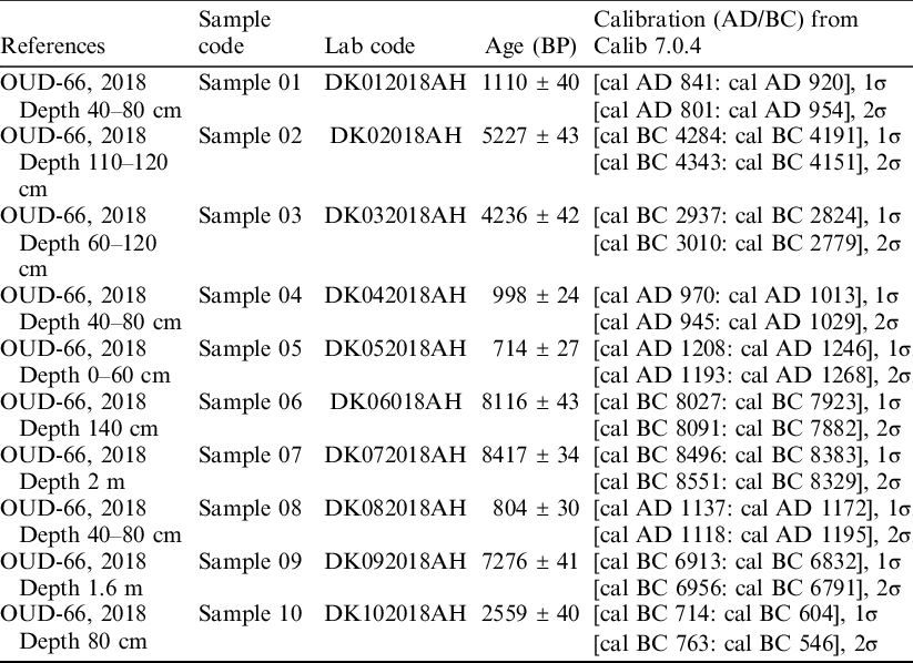
Moreover, the calibration of some samples collected at Missirah are from the beginning of the age of iron, this is the case of sample 07 on its lower terminal [cal BC 8551: cal BC 8329]. The other samples (998 ± 24 BP) [cal AD 1092], on its upper terminal, sample 05 [cal AD 1193: cal AD 1268] on its two terminals, as well as sample 08 [cal AD 1118: cal AD 1195], on its two terminals are contemporaneous with the dates obtained in the Delta of the Saloum (Thilmans and Descamps Reference Thilmans and Descamps1982; Camara et al. Reference Camara, Hardy, Dioh, Gueye, Piqué, Carrée, Sall and Diouf2017). In addition, samples 07 and 06 are from the 9th millennium BC and therefore predate all Neolithic dates found in Senegal (Deschamps Reference Deschamps2013; Kébé Reference Kébé2017). The question that can be asked is their chronological reliability and cultural affiliation based on the survey done. However, in the “Saloum” space, the question of cultural belonging of samples and vestiges is a real equation. Especially since the consideration between sample 07, 7th millennium BC, and sample 02, 5th millennium BC, the hiatus is more than 2 millennia as the original layer of sample 09 (1.6 m) is deeper than that of sample 02 (1.2 m). Even more paradoxical, the difference between sample 02 (1.2 m) and sample 06 (1.4 m) is more than 4 millennia. So, the “layered” dates have occupancy gaps of more than a millennium. Such a hiatus is difficult to explain. In addition, between [cal BC 4343–cal BC 4151] (sample 02) and [cal BC 3010–cal BC 2779] (sample 03), the score is more than a millennium (upper and lower bounds).
Beyond this, the hiatus between sample 03 and sample 01 is within the BC–AD transient range, while sample 10 ([cal BC 763: cal BC 546]) corresponds to the early onset of iron metallurgy. Moreover [cal AD 801: cal AD 954] for sample 01 belongs to the known period of the “tumular areas” of the Saloum Delta (9th–10th century AD). All of these dates are part of the accepted timeline of the Saloum Delta and surrounding sites. This sequence is contemporary with the so-called “protohistoric” dates in the wake of the division into “provinces” of the shellfish clusters and megalithic sites of the Saloum. The BC dates (upper bounds of all the samples considered are marked by a hiatus, such is the case between sample 06 and 07 corresponding to the 9th millennium, sample 09 in the 7th millennium BC and the terminal phase of the BC ages, “sample 10.” Between the samples, the nuance or the time difference is more than 6 millennia on the two markers taken.
Beyond that, the population dynamics ([cal BC 3010: cal BC 2779]), meaning from the 4th to the 3rd millenary BC, will be followed by an abandonment then a resumption: [cal AD 1193: cal AD 1268]. Between these dates the hiatus is several millennia. AD dates are part of the overall chronology of the “Saloum.” On the other hand, the dated BC samples, in their archaeological context, raise the question of archaeological occupations and open new avenues of research in the Saloum Delta.
ACKNOWLEDGMENTS
We thank all the researchers and technicians who contributed to the production of these dates and who allowed their publication. Particularly, our thanks go to Prof. Ibrahima Thiaw of the Laboratory of Archaeology at Cheikh Anta Diop University, and Alpha oumar Diallo of the radiocarbon laboratory of IFAN CH. A.Diop for his constant support and cooperation.


