


INTRODUCTION
The Moskva (Moscow) River is a tributary of the Oka River that flows into the Volga River and further into the Caspian Sea (Figure 1, inset). Approximately 70% of the Moskva River discharge originates from the atmospheric precipitation, with over 60% in the form of snowmelt. The water discharge was maximal between 19,000 and 13,000 cal BP, which led to the incision of the riverbed deeper than its current level (Panin et al. Reference Panin, Sidorchuk, Baslerov, Borisova, Kovalyukh and Sheremetskaya2001; Borisova et al. Reference Borisova, Sidorchuk and Panin2006; Sidorchuk et al. Reference Sidorchuk, Panin and Borisova2009). During this period, the river formed macro-meanders with the wavelength of 1300–1800 m that are still manifested in the valley (Figure 1).
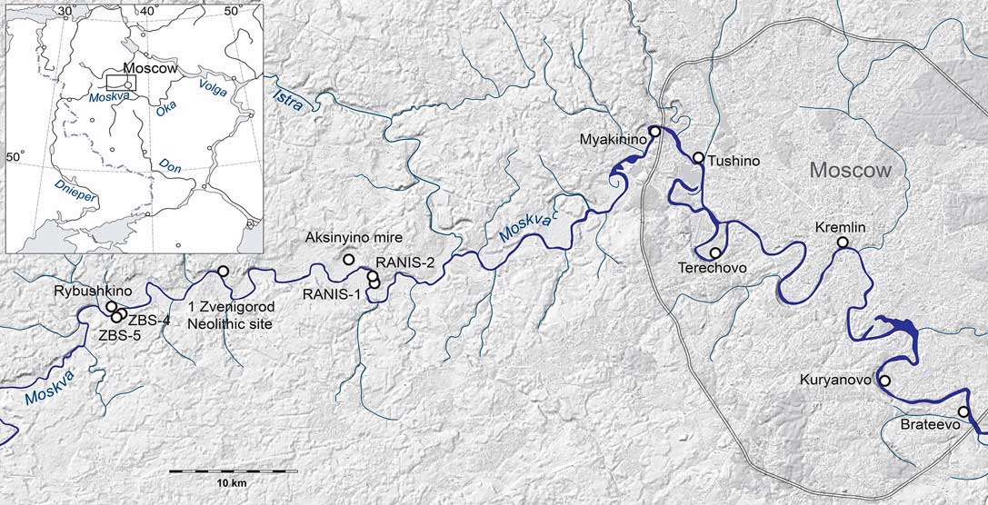
Figure 1 Locations of study sites.
Following a decrease in the water discharge ~12,000 BP, a system of small meanders, with a wavelength of 350–500 m, was formed. The size and morphology of these meanders corresponds to the modern river discharge. Up to 80% of the modern floodplain area was shaped already at the end of the last glaciation (Panin Reference Panin2008). In the Holocene, the changes in the course of the river channel were relatively small and not ubiquitous. On the high ancient surface of the floodplain, deposition of alluvium was discontinuous and took place only in some periods of the Holocene. The most active sedimentation with especially high flooding took place in the 17th to 19th centuries AD, and led to the leveling of the floodplain topography (Alexandrovskiy and Panin Reference Alexandrovskiy and Panin2013). The periods of interruption of the alluvial sedimentation on the floodplain of the Moskva River in the Holocene were marked by the development of paleosols (Alexandrovskiy and Panin Reference Alexandrovskiy and Panin2013).
The dark-colored paleosols containing artifacts were first discovered by archaeologists in the floodplain deposits of the Oka River (Gorodtsov Reference Gorodtsov1928; Efimenko Reference Efimenko1934). Such paleosols of various taxonomic types were also found in the floodplain deposits of other rivers in the East European Plain (Voropay and Kunitsa Reference Voropay and Kunitsa1970; Sycheva and Usyanov Reference Sycheva and Usyanov1987; Sycheva Reference Sycheva1999, Reference Sycheva2006, Reference Sycheva2009). The paleosols were ordinated into chronosequences that allowed to analyze paleoenvironmental changes and anthropogenic transformation of the floodplains in the Holocene (Plyusnin Reference Plyusnin1938; Aseev Reference Aseev1959).
The first finds prompted a large number of archaeological and paleogeographic studies of multilayered archaeological sites in the floodplain of the Oka River and other rivers of the Central Russian Plain (Khotinsky et al. Reference Khotinsky, Folomeev and Guman1979; Glasko and Folomeev Reference Glasko and Folomeev1981; Glasko Reference Glasko1983; Alexandrovskiy and Chichagova 1998). These studies revealed the widespread distribution of well-developed paleosols of various origins, such as the Luvisols and Chernozems, in the floodplain settings; furthermore, these paleosols could be attributed to certain stratigraphic units of the Holocene (Alexandrovskiy et al. Reference Alexandrovskiy, Glasko and Folomeev1987). The floodplain paleosols of the Oka River were numbered from 1 (a soil, developed on the modern surface) to 4 (a paleosol of the mid-Holocene age). In the most complete section, Klimenty, all of the four paleosols encased artifacts and occupational layers dated back to the Neolithic–Medieval periods (Folomeev et al. Reference Folomeev, Alexandovskiy, Glasko and Guman1988). The paleosol 2 was the most common one, and it was found in many locations within the Oka River floodplain; in some cases, it hosted occupational layers of the Iron Age.
Somewhat later, geoarchaeological investigations were initiated in the Moskva River floodplain (Krenke et al. Reference Krenke, Alexandrovskiy, Ladychenko, Petrov and Yanishevskii2001). These studies also revealed a series of paleosols. Overall, seven soils with the ages ranging from the Allerød period to the modern times were identified (Alexandrovskii Reference Aleksandrovskii2004). According to the results of 14C dating, the upper four paleosols of the Moskva River floodplain have the ages similar to those of the paleosols of the Oka River (Alexandrovskiy 2004; Alexandrovskiy and Glasko Reference Alexandrovskiy and Glasko2014). The modern soil has an age of ~400 cal BP; the Soil 2 has dates ranging from 800 to 2700 cal BP; the Soil 3 from 3200 to 4700 cal BP; and the Soil 4 from 5300 to 7000 cal BP. Three more paleosols (nos. 5–7) described in the Moskva River floodplain were absent in the Oka floodplain. The ages of the paleosols allowed us to attribute their formation to certain climatic phases of the Holocene according to the Blytt-Sernander periodization, modified by Khotinsky (Reference Khotinsky1977): the Soil 2 formed during the Subatlantic (<2600 cal BP); the Soil 3 during the Subboreal (2600–5700 cal BP); the soils 4 and 5 during the Atlantic (5700–8900 cal BP); Soil 6 in the Boreal (8900–11,500 cal BP); and Soil 7 during the Allerød (13,600–12,900 cal BP) time period.
The paleosols were formed in different paleoenvironments. The lower paleosols 4, 5, 6, and 7 (Phaeozems and Chernozems) had dark-colored humus horizons, associated with the grassland vegetation. The paleosol 2 (Luvisols and Albeluvisols) had a textural differentiation consistent with the soil formation under the forest vegetation: a “leached” cinder-white AE horizon, underlain by a clay-enriched Bt horizon. The paleosols 1 and 3 were less developed and had more variable features, suggesting a complex history of development. The soils often merge together, especially the lower ones that may be merged into a single Soil 4-6 (Figure 4). Upper soils (nos. 1–3), on the contrary, are often stratified; for example, Soil 2 on the Oka River, or Soil 3 on 3a and 3b on the Moskva River.
Following these initial assumptions, a palynological study of the paleosols was carried out in the Moskva River floodplain (Ershova et al. Reference Ershova, Alexandrovskiy and Krenke2014, Reference Ershova, Alexandrovskiy and Krenke2016a, Reference Ershova, Alexandrovskiy, Krenke and Korkishko2016b). In several sections, both the amount and degree of preservation of palynomorphs were sufficient for the analysis, whereas the other sections did not contain pollen. The sites near Zvenigorod (ZBS, RANIS-1, RANIS-2) yielded the most informative palynological data. The Soil 4 of the Atlantic period (a Phaeozem) contained pollen of both forest and grassland taxa (Ershova et al. Reference Ershova, Alexandrovskiy and Krenke2014). The Soil 3 of the Subboreal period (the Zvenigorod Biological Station (ZBS) site), a Luvisol, contained pollen of the forest vegetation (Ershova et al. Reference Ershova, Alexandrovskiy and Krenke2016a, Reference Ershova, Alexandrovskiy, Krenke and Korkishko2016b). The Late Holocene paleosol, designated as the Soil 2 in our stratigraphic scheme, was formed during the Subatlantic period (from 2700 to 800 cal BP). This soil was more common than other floodplain paleosols; in most cases, this soil was developed on the loamy alluvium, but buried by the sandy alluvium. The Soil 2 had the morphological features of Luvisols and Albeluvisols. However, the morphology of this soil varied considerably among different sections, which could be explained either by the differences in the local lithological and geomorphic conditions, or by the differences in the land use. The Soil 2 was formed during two archaeological epochs: the Iron Age and the Early Middle Ages. Archaeological surveys of the Moskva River floodplain have revealed the presence of numerous ancient settlements during this time period (Krenke Reference Krenke2011; Krenke et al. Reference Krenke, Ershov, Ershova and Lazukin2013). The palynological spectra of the Soil 2 contained various anthropogenic indicators, such as pollen of cultivars and weeds, and indicators of compaction, and this is consistent with the utilization of the floodplain for pastures and droveways. The data suggests that local differences in the Soil 2 morphology may be related to the anthropogenic impact on the river floodplain from the Early Iron Age onwards (Alexandrovskiy and Krenke Reference Alexandrovskiy and Krenke2004; Ershova and Krenke Reference Ershova and Krenke2014; Ershova et al. Reference Ershova, Alexandrovskiy, Krenke and Korkishko2016b).
This paper aims to summarize all 14C dates obtained for the paleosols of the Moskva River, including new AMS 14C values of charcoal from the paleosols. The main objective of this paper is to validate the stratigraphic correlation of the paleosols from various locations by means of 14C dating, and to evaluate possible discrepancies between the dates obtained on different materials.
MATERIALS AND METHODS
The study area is located within the boundaries of the Moscow glaciations, and is composed of glacial, glaciolacustrine, lacustrine, and alluvial deposits. The valley of Moskva River includes the floodplain, three terraces, and the valley sanders. The total width of the valley does not exceed 1.3 km. The modern floodplain is elevated at about 5 m above the mean water level. It is composed of loamy and, less frequently, sandy deposits. The first and the second terraces and the valley sanders consist mainly of sands. The modern vegetation on terraces is a mixed forest with pine in the canopy in most areas; the floodplain is treeless with a narrow band of shrub willows and alders along the stream. Modern soils are Luvisols and Podzols on the terraces and Fluvisols in the floodplain. The locations of study sites are shown in Figure 1.
Kuryanovo section (55°39′35″N; 37°40′30″E) was the subject of archaeological surveying on the left bank of the Moskva River, within the Moscow City limits, across the river from the D’yakovo and Chertov Gorodok habitation sites of the Iron Age. The floodplain surface is elevated here for 4.5 m above the modern river level. The Soil 2 is superposed over the Soil 3 in this section and is overlain by the 120–135-cm-thick loamy sand alluvium. In the left part of the section, an A horizon of the Soil 5 was preserved at the depth of 265 cm. A full description of this section is given in Alexandrovskiy and Krenke (Reference Alexandrovskiy and Krenke2004).
Terekhovo section (55°44′42″N; 37°28′10″E) is located on the left bank of the river, within the Moscow City limits. The floodplain surface is elevated for 5 m above the river level. Well-developed Albeluvisol with the light-gray colored AE horizon (depth of 160–182 cm) bedded over a 1-m-thick Bt horizon (depth of 200–300 cm) with a well-shaped angular blocky structure and argillans on ped surfaces was described. This soil was identified as a Soil 2 (or Soil 2-3a)Footnote 1 . Below, at the depth of 300 cm, the dark-grey humus horizon was recorded. The morphology of this horizon is similar to the morphology of Phaeozems that were earlier investigated somewhat upstream (Ershova et al. Reference Ershova, Alexandrovskiy and Krenke2014) and were described as a Soil 5. The morphological similarity allowed us to tentatively identify this soil as a Soil 5. A full description of this section is given in Alexandrovskiy and Krenke (Reference Alexandrovskiy and Krenke2004).
Tushino section (55°48′36″N; 37°25′48″E) is located on the left bank of the river, within the city limits, at a low elevation (~2.5 m above the river level). Three soil formations were described in the section (Figure 2): a Luvisol with a well-developed Bt horizon was bedded at the depth of 120–135 cm; this was identified as the Soil 2. Soil 3a-5 was bedded at the depth of 165–183 cm. At the depth of 207–215 cm, we found a soil dating back to the Allerød period, the most ancient paleosol in the floodplain setting on the Russian Plain; this was designated as Soil 7. A detailed description of the soil profile is given in the Alexandrovskiy et al. (Reference Alexandrovskiy, Ershova and Krenke2016).

Figure 2 Stratigraphy of paleosols in selected study sites.
RANIS 1 section (55°43′30″N; 37°02′45″E) is located near the village of Nikolina Gora, on the right bank of the river, at the height of 5.5 m above the water level. Three paleosols 2, 3, and 4 are separated by layers of alluvium (Figure 2); with the occupational layer of the Bronze Age bedded on the surface of the Soil 3b (Krenke et al. Reference Krenke, Ershov, Ershova and Lazukin2013). Soils 2 and 3 had distinct light-gray humus horizons; Soil 2 also had the Bt horizon and was attributed to the Luvisols. Soil 4-6 (a complex profile) had a dark-gray humus horizon, and was attributed to the Phaeozems. The section is located within 1.5–2 km from settlements of the Dyakovo culture of the Iron Age. This section represents the most comprehensive set of paleosols in the Moskva River floodplain according the number of buried soils and their high degree of preservation; moreover, the paleosols have a well-preserved pollen (Spiridonova et al. Reference Spiridonova, Aljoshinskaya and Kochanova2008; Ershova et al. Reference Ershova, Alexandrovskiy, Krenke and Korkishko2016b).
RANIS 2 section (55°43′41″N; 37°02′42″E) (Figure 3) is located 1.6 km upstream from RANIS-1, on the right bank of the river, at the level of 6 m above the water level. The floodplain is currently used as a farmland. The section is located within 1 km from Medieval burial mounds and the fortified settlement of the Iron Age named Uspenskoye-1. The stratigraphy is similar to that of RANIS-1, but with a greater thickness of soils 2 and 4-6 (Figure 2). The Soil 2 in this section had a weekly developed Bt horizon and could not be designated as either Luvisols or Albeluvisol, in contrast to the Soil 2 in other sections. The Soil 4-6 has a remarkably thick and dark-colored A horizon and a transitional AB horizon with krotovinas of a large (7–9 cm) diameter, corresponding with the tunnels of grassland rodents. Detailed descriptions of soil profiles and pollen data of sections RANIS-1 and RANIS-2 are in Ershova et al. (Reference Ershova, Alexandrovskiy, Krenke and Korkishko2016b).

Figure 3 Stratigraphy of paleosols in RANIS-2 site.
Aksinyino mire (55°43′46″N; 37°02′40″E) is located in the floodplain west of the sites RANIS-1 and RANIS-2, within a “cup-shaped” depression—an old oxbow with the radius of 700 m. Prior to the ameliorative work, this was one of the largest lowland mires in the Moskva River valley, fed by the spring with a highly mineralized groundwater. Its surface area was estimated at 137 ha; with the depth of peat deposits varying from 2 to 5 m. Swamp vegetation of the mire is diverse and includes several unique species, a relic of the Late Glacial times. At this site, the Soil 4-6 was traced within a trench 500 m across the floodplain; bedded under the alluvial deposits in some areas and under the peat facies within the contours of Aksinyino mire (Ershova et al. Reference Ershova, Alexandrovskiy, Krenke and Korkishko2016b). The peat bog was included in the paleopedological analysis as the beginning of the peat accumulation marked the major change in the hydrological regime of the floodplain: the onset of recurring flooding after an almost 5000-yr-long time period of automorphic soil development.
ZBS-4 (55°42′16″N; 36°44′8″E). Zvenigorod Biological Station of the Moscow State University (ZBS) is located 7 km upstream from the sites RANIS-1 and RANIS-2, on the right bank of the river. A 51 m2 pit ZBS-4 was excavated in the periphery part of the floodplain, at the base of the alluvial fan of a small stream. Under the modern humus horizon, the plough layer of the 20th century was bedded. Both the Soil 1 and Soil 2 were merged together by plowing, as indicated by the large number of pottery shards and burnt clay fragments of the 13th century AD in the plough layer. Two buried soils with the artifacts of the Bronze Age (Fatyanovo and Abashevo cultures) were bedded beneath the plough layer (Krenke et al. Reference Krenke, Ershov, Ershova and Lazukin2013). The dark-colored Soil 4 consisted here of four humus horizons, divided by thin depositional layers. The detailed descriptions of the soil profiles ZBS-4 are published in Krenke et al. (Reference Krenke, Ershov, Ershova and Lazukin2013); Ershova et al. (Reference Ershova, Alexandrovskiy and Krenke2016a).
Rybushkino section (55°42′36″N; 36°45′18″E) (Figure 3) is located near the Zvenigorod Biological Station, on the left bank of the river. In this section, a profile of the Albeluvisol was found under a thin layer of the recent alluvium accumulated in the 17th–19th centuries AD (Figures 2 and 4). Below, a thick dark-grey humus horizon of the Phaeozem was bedded. We identified it as the Soil 2-6 that was developed during a long period of stability of the floodplain surface, possibly in the first half of the Holocene. However, the large thickness of the dark-colored layer could result from the superposition of the two soils that formed in the Middle and Late Holocene (Soil 4-6 and Soil 2-3). Detailed descriptions of the soil profiles are published in Alexandrovskiy and Panin (Reference Alexandrovskiy and Panin2013).

Figure 4 Stratigraphy of paleosols in Rybushkino site.
Zvenigorod Neolithic site (55°43′54″N; 36°50′42″E) is located on the left bank of the Moskva River within the Zvenigorod City limits. The floodplain here is only about 50 m wide, but 5.6 m high, with a steep river bank. In the central and peripheral part of the floodplain, the soil surface is covered with a thin layer of recent artificial deposits. Three soils are revealed in the overbank alluvium: one modern soil and two paleosols—S3b and S4. The Neolithic occupational layer is bedded at the depth of 0.5 m above the current low-stand of the river, on the surface of the dark-grey humus horizon of the Soil 4 (Phaeozem). Soil 3b lies 50 cm higher and has an underdeveloped profile (Ershova et al. Reference Ershova, Alexandrovskiy and Krenke2014).
Kremlin (55°45′20″N; 37°37′12″E). This section is located in the peripheral part of the floodplain in the southeastern part of the Moscow Kremlin. An ancient sand bar was found under the occupational layer of 12th century AD. This section exposed a Luvisol (presumably, the Soil 2), and an immature soil of the Allerød/Younger Dryas (12,530±113 cal BP), represented by a thin humus layer. Closer to the Moskva River, incipient Fluvisols of the Medieval age were found.
Myakinino (55°49′30″N; 37°23′20″E) is located on the right bank of the river, within the city limit of Moscow. The archaeological excavations revealed a sand bar buried under the modern sandy alluvium. The Soil 2 on the surface of the sand bar contained artifacts of the Early Iron Age and of the Medieval time (Alexandrovskiy et al. Reference Alexandrovskiy, Glasko, Krenke and Chichagova2004).
Radiocarbon dating. The age of paleosols was estimated using archaeological and 14С-dating methods. The 14C dates were obtained on soil humus by the liquid scintillation counting at the Kiev Laboratory (lab code Ki); the Geological Institute RAN, Moscow (GIN); and the Laboratory of the University of Helsinki (Hela). The technique for preparing samples of humus and other materials in the laboratory of Kiev is provided in Skripkin and Kovalyukh (Reference Skripkin and Kovalyukh1998). The method of preparation of samples in the laboratory GIN (or Institute of Geology RAS, Moscow) is described by Zaretskaya et al. (Reference Zaretskaya, Ponomareva and Sulerzhitsky2007). The AMS 14C dates were obtained for charcoal at the University of Ottawa (UOC), and University of Georgia, USA (UGAMS). Sample pretreatment techniques and definitions of media codes for the samples processed at the AEL AMS Laboratory of the University of Ottawa can be found in Crann et al. (Reference Crann, Murseli, St-Jean, Zhao, Clark and Kieser2017). Calibration of dates was carried out using the OxCal calibration program (Reimer et al. Reference Reimer, Bard, Bayliss, Beck, Blackwell, Bronk Ramsey, Buck, Edwards, Friedrich, Grootes, Guilderson, Hajdas, Hatté, Heaton, Haflidason, Hogg, Hughen, Kaiser, Kromer, Manning, Niu, Reimer, Richards, Scott, Southon, Turney and van der Plicht2013).
Pedoanthracological analysis. The amount of 3–7 kg of soil mass was used for the analysis. The soil samples were air-dried and then wet-sieved through the 0.6-mm sieve, and the large fractions were analyzed. Charcoal identification was carried out under an incident-light microscope, using wood anatomy manuals (Barefoot and Hankins Reference Barefoot and Hankins1982; Schweingruber Reference Schweingruber1990), and reference collections. We intended to identify up to 50 fragments from each layer, but the actual number of identifiable fragments varied depending on the size and preservation of the charcoal. All components of the charcoal assemblages, including charred wood, bark, annual shoots of shrubs, needles, and seeds, were described. In addition, carpological analysis was performed in the soil fraction >0.6 mm of the samples processed for the pedoanthracological analysis.
RESULTS AND DISCUSSION
Chronology of the Paleosols
Seventy 14C dates were obtained for the soil humus (humic acids), peat, and charcoal (Table S1). Distributions of the dates are shown on the Figure 5.

Figure 5 14C dates obtained on charcoal (black) and humus (gray); stars (*) indicate the materials associated with archaeological features.
The dates formed several distinct clusters, consistent with the stratigraphic scheme proposed by Alexandrovskiy (2004).
Soil 7 (the oldest paleosol in the sequence) forms a dense cluster of dates, with the ages ranging from 14,600 to 12,600 cal BP (here and below, the ranges are given for 95% probability distributions). The dates obtained on the soil humus in the Kremlin appear rejuvenated, which is common for the 14C values of the soil organic matter.
The next stage of the soil formation began almost 3000 years later. Soils 4, 5, and 6 were formed during the time period from 9500 to 5500 cal BP. All these soils have a dark-colored humus horizon typical for the Phaeozems and Chernozems (Ershova et al. Reference Ershova, Alexandrovskiy and Krenke2014, Reference Ershova, Alexandrovskiy, Krenke and Korkishko2016b).
The 14C dates of the Soils 5 and 6 vary within a wide range, from 9500 to 7000 cal BP, and appear to form a continuum of ages rather than two distinct clusters. This may reflect a series of flashfloods that caused local soil erosion and surface burial.
The Soil 4 is characterized by a compact cluster of 14С dates ranging from 6900 to 5500 cal BP. This soil has a well-developed dark-colored humus horizon typical for the Phaeozems and Chernozems (Ershova et al. Reference Ershova, Alexandrovskiy and Krenke2014, Reference Ershova, Alexandrovskiy, Krenke and Korkishko2016b). The formation of this soil was ceased by 5500–5000 cal BP, as indicated by the age of the basal peat layer of Aksinyino mire bedded on the surface of Soil 4.
The Soil 3 was a transitional formation that possessed morphological features of the forest soil (bleached Ae horizon) at some sites, while in the other sites it had a dark-colored humus layer typical for the grassland soil. The 14C dates for the Soil 3 are clustered into four groups. The first group, 5000–4500 cal BP, designated as the Soil 3b, is close to the cluster of 14C dates of the Soil 4. The artifacts and hearth features of Bronze Age (traditions of Cordware Ceramics and Globular Amphora, as well as Fatyanovo culture formed on the base of these two traditions) were bedded on the surface of the Soil 3b. Charcoal from the features yielded dates ranging from 4700 to 4500 cal BP. Archaeological features and artifacts of the Abashevo culture with dates ranging from 4000 to 3700 cal BP were bedded within the alluvial deposits dividing soils 3b and 3a (Krenke et al. Reference Krenke, Ershov, Ershova and Lazukin2013; Ershova et al. Reference Ershova, Alexandrovskiy and Krenke2016a). Finally, the Soil 3a is characterized by a cluster of dates ranging from 4100 to 2700 cal BP. Apparently, the episodes of the formation of this soil were asynchronous in different segments of the floodplain, which could point to an instability of the surface during this time period, possibly due to a combination of the fluvial erosion/accumulation processes and the slope processes, affected by the local mechanical disturbances (such as grazing and trampling).
The Soil 2 is represented by the most dense cluster of dates ranging within narrow limits, from 1400 to 700 cal BP. At some sites, the deposits dividing Soil 2 and 3 are thin, and the soils are welded together as reflected in the overlap in the 14С dates.
The age of the modern soil was not determined by means of 14C dating: it was estimated using the age of artifacts associated with this soil, belonging to the last 5 centuries. The deposits dividing Soil 2 and the modern soil contained charcoal dated to 350–450 cal BP.
The analysis of the 14C dates revealed some dissimilarities between the chronosequences of paleosols in the Oka and the Moskva Rivers. The differences can be explained by the fact that the grassland stage of the soil formation in the Oka River floodplain was longer than in the floodplain of the Moskva River. The transition took place during the formation of the Soil 3; therefore, the Soils 3 that formed during the same period could develop under the grassland vegetation in the Oka River floodplain, and under the forest cover in the Moskva River floodplain. In the latter, the Soil 3 can be divided into two facies: the upper/younger Soil 3a that has in some cases a bleached AE horizon; and the lower/older Soil 3b that has a dark-colored humus layer, e.g. in the RANIS-1 site (Ershova et al. Reference Ershova, Alexandrovskiy and Krenke2016a, Reference Ershova, Alexandrovskiy, Krenke and Korkishko2016b). The latter is close to the age of the Soil 4 in the Oka River paleosol sequences. Therefore, the detailed analysis of the 14C dates allowed us to verify and modify the initial paleosol chronology for the Moskva River floodplain.
Vegetation Dynamics and Anthropogenic Impact
The results of the pollen analysis of the paleosols (Ershova et al Reference Ershova, Alexandrovskiy and Krenke2014, Reference Ershova, Alexandrovskiy and Krenke2016a, Reference Ershova, Alexandrovskiy, Krenke and Korkishko2016b) indicate clear differences between the vegetation cover of the Soil 4 and the soils 1, 2, and 3. The Soil 4 contains pollen of herbaceous vegetation, whereas the pollen assemblages from the Soil 3 are dominated by the arboreal pollen, represented mainly by spruce.
The results of the anthracological analysis of the paleosols are presented in the Table 1. The Allerød paleosol (Soil 7) and the Atlantic-Boreal paleosol (Soil 4-6) do not contain any arboreal charcoal in the fraction >1 mm. However, fragments of charred grass stems were recorded in the Soil 7 and in the deposits dividing the Soil 4-6 into upper (4) and lower (4-6) parts, indicating that fires affected here the grassland vegetation. The time of the fire occurrence falls within the Mesolithic and the Neolithic epochs. Two charred fragments of pomaceous trees were recovered from the surface of the Soil 4a in the RANIS-2 section.
Table 1 Charcoal assemblages of paleosols in the Moskva River floodplain.

The situation changed drastically in the deposits covering the Soil 4: large fractions of the soil mass contained charcoal and numerous charred needles of spruce. Following the depositional episode, the Soil 3b was formed. Large fractions of this soil contained mainly reburned wood charcoal, and seeds of Chenopodium sp., Atriplex sp., and Silene sp.—the zoochoric species commonly associated with grazing. The time of the fire occurrence corresponds to the Bronze Age. At the ZBS-5 site, both artifacts and hearth features of the Bronze Age were recorded on the surface of the Soil 3b (Fatyanovo culture), and in the deposits dividing the soils 2 and 3b (tentatively identified as Abashevo culture). The hearth features contained oak and ash charcoal. Dispersed oak charcoal was found also in the Soil 3a in the Tushino site.
The large fractions of the Soil 3a in the RANIS-2 section contain mainly reburned spruce charcoal, and seeds of Chenopodium sp., Atriplex sp., and Silene sp. associated with grazing. The time of the fire occurrence corresponds with the Early Iron Age, and the dates correlate with the age of the Dyakovo culture. The settlements of Dyakovo culture are documented in the vicinity of the studied sites.
The deposits bedded on the surface of the Soil 3a contained predominantly spruce charcoal and charred needles, with a small proportion of rounded (transported/redeposited) oak charcoal in the RANIS-2 site; and only oak at Tushino and Brateevo sites.
Following the depositional episode, the Soil 2 was formed. The layers of charcoal bedded on the surface of this soil are well visible at Tushino and Brateevo sites. The pyrogenic layers contain oak charcoal and charred bark. At the RANIS-2 site, the Soil 2 contain fragments of pine charcoal, mainly reburned, seeds of Atriplex, and charred seeds of grasses. In the ZBS-5 site, fragments of iron-impregnated (possibly, redeposited) pine and spruce charcoal, charred stems of thorny shrubs, charred stems of grasses, and seeds of Chenopodium and Atriplex are found. The charcoal assemblages from RANIS-2 and ZBS-5 sites are consistent with the frequent burning of the floodplain for pastures. The age of charcoal at all sites ranges from 820 to 1200 cal BP, indicating a wide-spread fire occurrence in 9th–13th centuries AD. This is the time period of Slavic colonization of the Moscow River valley (Krenke Reference Krenke2008).
Our results indicate that from ~4700 years ago onwards, the floodplain was re-grown by the forest dominated by either spruce or oak during the periods of depopulation, and was cleared and burned for pastures when peoples occupied the landscape. The last episode of burning and clearing the spruce forest in the floodplain of the Moscow River is dated to 490–300 cal BP: this age is consistent with the historical descriptions of the “Great Russian Land Clearance” that took place in the Russian State in the 15th and 16th centuries AD (Milov Reference Milov2001).
The Dynamics of Flooding
Presumably, each episode of the soil formation in the floodplain reflected a time period with infrequent and/or short-term flooding, and each episode of sedimentation between the paleosols marked the periods of the frequent and/or prolonged flooding. The degree of the soil development is a function of time. Generally, the thickness of humus layers is proportional to the lifetime of the grassland soil; whereas in the forest setting the lifetime of the soil corresponds to the degree of the textural differentiation, e.g. the amount of clay accumulated in the B horizon. The most developed paleosols of the Moskva River floodplain are the grassland Soil 4 that formed in the mid-Holocene, between 6900 and 5500 cal BP, and the forest Soil 2 that formed in the late Holocene, between 2000 and 700 cal BP. These two episodes of the soil formation marked the prolonged periods in the Holocene when the river valley was not flooded, either due to the low precipitation or low run-off from the catchment area. Human settlements existed within the floodplain during these periods, associated with the Neolithic, the Bronze Age, and the Early Iron Age (Krenke Reference Krenke2008, Reference Krenke2012).
The deposits between the paleosols assumed to be alluvial and, hence, related to the flooding episodes. The deposits dividing the paleosols 3, 4, 5, 6, and 7 are loamy at all studied sites, and the deposits between paleosols 2 and 1 are sandy. The thickness of the deposits dividing the paleosols 4, 5, 6, and 7 varied greatly both within each section and among the sections, ranging from several centimeters to several meters. That reflected the major role of local factors of sedimentation, such as the landslides that could provide a sediment supply for a further reworking by the fluvial and slope processes within river segments. The changes in the flooding regime ca. 5000–4500 cal BP coincided with the major changes in the vegetation cover: an appearance of the forest vegetation within the floodplain, and an onset of the peat accumulation at the Aksynyino mire (4500 cal BP). This is the second episode of paludification that took place almost 5000 years after the beginning of the peat accumulation in watershed depressions on the Boreal period of the Holocene (Khotinsky Reference Khotinsky1977).
The changes in the grain size composition and the provenance of the alluvial deposits ca. 800 years ago implied major changes in the hydrological regime, such as the drastic increase in the runoff. The massive unit of laminated alluvial deposits, 1–3 m thick was formed following these changes. During this time period, the initially forested landscape was affected by a large-scale (a valley-wide) deforestation as indicated by the layers of charcoal on the surface of the Soil 2 in all studied sections, as well as the reburned charcoal and seeds of anthropochores in the covering deposits. It appears that this period of high-intensity floods may be attributed to the anthropogenic impact, associated with the deforestation of the watersheds. Though some increase in precipitation was associated with this time period, its effect on the local hydrology was definitely anthropogenically amplified.
The comparison of the time periods of paleosol formation with the regional paleohydrological phases and events (Panin and Matlakhova Reference Panin and Matlakhova2015) shows a reasonable correlation between the episodes of the low hydrological activity and the ages of paleosols. Overall, four distinct low activity (LAP) and 4 high activity (HAP) phases and events were identified in Central Russia for the Holocene (Panin and Matlakhova Reference Panin and Matlakhova2015). The ages of the Soil 2 correspond to a low activity phase (LAP) centered around 1300 cal BP, Soil 3a was formed during the LAP 2500–3000 cal BP, and Soil 4—during the LAP 6200–6500 cal BP, but our dates indicated that the last LAP began earlier (ca. 6900 cal BP) and lasted until 5500 cal BP. The change from the LAP to the HAP was marked by the onset of the peat accumulation in the Aksinyino mire. The LAP 7500–8200 cal cal BP coincided with the time of formation of soils 5 and 6, but our data do not support the long-term low stand, rather indicating numerous short-term episodes of flashfloods disrupting the soil formation. Finally, the formation of Soil 7 was contemporaneous to the sharp decrease in HAP centered around 15,000 cal BP.
The analysis of the large group of dates obtained from the paleosols and alluvial layers of the Moskva River showed that the ages of the same soils in different sites were not completely synchronous. Taking into account the age differences, the previously proposed chronological frames for the soil formation were changed, and the chronology diagram was refined: Soil 3 was divided into 3a and 3b. The division of Soil 2 into S2a and S2b was described earlier on the Oka River (Alexandrovskiy and Glasko Reference Alexandrovskiy and Glasko2014).
CONCLUSIONS
The original paleosol chronology for the Moskva River floodplain (Aleksandrovskiy Reference Aleksandrovskii2004) was verified and modified based on the large set of the 14C dates obtained on various organic materials. The dates generated on charcoal and soil organic matter are similar to each other, and follow the same tendencies in clustering around the seven time periods of the paleosols formation. The 14C dates for soils 7, 4, 3b, 3a, and 2 form dense clusters, whereas the dates for soils 5 and 6 form a continuum without distinct age boundaries.
The 14C dates obtained on humus are generally older than the charcoal dates and the former vary in wider ranges. The wide time frames of the floodplain paleosol formation are determined with the 95% probability as 14,600–12,600 cal BP for Soil 7; 9500–7000 cal BP for soils 6 and 5; 6700–5500 cal BP for Soil 4; 5000–4400 cal BP for Soil 3b; 4100–2700 cal BP for Soil 3a; and 2000–700 cal BP for Soil 2. Based on the age distributions, the time periods of the stable development of the soils can be estimated as 2000 yr for Soil 7, 2500 yr for soils 6 and 5, 1400 yr for Soil 4, 600 yr for 3b, 1400 yr for Soil 3a, and 1300 yr for Soil 2.
The periods of the stable soil formation during these phases of a low hydrological activity were interspersed by the time periods of a high flooding activity at 12,600–9500 cal BP, 5500–4700 cal BP, 2700–2000 cal BP, and 700–400 cal BP. Major changes in the hydrological regime of the Moskva River occurred between 5000 and 4500 cal BP, when flooding became regular after a prolonged period with infrequent floods. The change in the hydrological regime was followed by the transition from grassland soils to the forest soils within the floodplain. Soils 7, 6, 5, and the lower part of Soil 4 do not contain the arboreal charcoal, whereas soils 1, 2, and 3 contain the charcoal and pollen assemblages consistent with the forested habitat.
The 14C dates obtained on soil charcoal are closely correlated with the known occupations of Lyalovo (Soil 4), Fatyanovo and Abashevo (Soil 3b and deposits dividing Soils 3a and 3b), Dyakovo (Soil 3a and Soil 2), and Slavic archaeological cultures and the large-scale land clearance for agriculture in the Early Russian State (Soil 2). From approximately 5000 cal BP onwards, the floodplain was forested with the vegetation locally dominated by either spruce or oak. Beginning of each colonization wave was marked by clearing (and burning) of the floodplain forest. The charcoal assemblages from soils 3a, 3b, and 2 contained seeds of zoochoric weeds and pollen of taxa associated with grazing, indicating the utilization of the floodplain for pastures. It can be concluded that the floodplain was maintained as a grassland during the time periods of human colonization, and was reclaimed by the forest during depopulation episodes.
ACKNOWLEDGMENTS
Investigations were partly financially supported by the Russian Science Foundation, project No.14-27-00133 (in part of the investigations soil studies and radiocarbon dating) and Russian Foundation for Basic Research No.16-04-01717 (in part of the paleoanthracological investigation and AMS dating).
Supplementary material
To view supplementary material for this article, please visit https://doi.org/10.1017/RDC.2018.73


