


1 INTRODUCTION
The archaeological record of Gravettian-Epigravettian hunter-gatherers across Western Eurasia is traditionally considered to be an expression of human adaptation to harsh climatic conditions, up to very extreme in some cases. In central-northern Europe, ecological conditions in the loess belt during MIS2 and especially the last glacial maximum (i.e. 30 to 18 ka cal BP, Lambeck et al., Reference Lambeck, Yokoyama and Purcell2002), were mostly treeless and provided limited resource availability. However, the settlement patterns documented in those periglacial environments are a demonstration of human culturally-mediated capability to overcome conditions of reduced biomass and ecological variability (Maier et al., Reference Maier, Lehmkuhl, Ludwig, Melles, Schmidt, Shao, Zeeden and Zimmermann2016). In Southern Europe, many of the regions where complete depopulation did not occur, despite rapid climatic changes, are located below the estimated altitudinal timberline, e.g 700 m above sea level in south-eastern Alps (Straus et al., Reference Straus, Bicho and Winegardner2000; Ravazzi et al., Reference Ravazzi, Orombelli and Tanzi2004; Schmidt et al., Reference Schmidt, Bradtmöller, Kehl, Pastoors, Tafelmaier, Weninger and Weniger2012). Milder climatic conditions and enhanced moisture supply at the northern Mediterranean rim supported tree growth and boreal and montane forest ecosystems, which included megaherbivores (Willis et al., Reference Willis, Rudner and Sümegi2000; Svenning et al., Reference Svenning, Normand and Kageyama2008; Monegato et al., Reference Monegato, Ravazzi, Culiberg, Pini, Bavec, Calderoni, Jež and Perego2015). These conditions were favourable both for hunter-gatherer subsistence and for their capability to maintain large-scale networks. Although this picture has been largely confirmed by lowland open-air and cave sites which testify to complex settlement patterns and usually record multiple occupations (Bocquet-Appel et al., Reference Bocquet-Appel, Demars, Noiret and Dobrowsky2005), little is known from those potentially inhabitable contexts situated in the mountain ranges in extreme conditions. The existence of specialized sites, temporary camps used for stone knapping, for hunting or performing other common practices of the subsistence cycle, constitutes a main source of information to reconstruct the timing and modalities of human occupation. Despite the low density of lithic objects, these contexts contribute to or reinforce our inferences about the existence of a wider settlement system in which specific anthropic activities were spatio-temporally displaced (Foley, Reference Foley1981) even in very severe environments.
Mountain areas are often characterized by rather scarce evidence of occupation dating to Middle and Upper Palaeolithic, mainly due to taphonomic processes or research intensity and accessibility (Tillet, Reference Tillet2002). However, whenever investigations are carried out and clusters of sites are disclosed, this pattern may be revised to reflect prehistoric reality. It is the case of this contribution which combines interdisciplinary data from investigations in the northern Apennines, Italy. This mountain range has a dearth of evidence dating to the Mid Upper Palaeolithic and, except for rare discoveries (Silvestrini et al., Reference Silvestrini, Peresani and Muratori2005), no advancements have been made in surveying other parts of this long, although easy to cross, mountain chain (Djindjian, 1994, Reference Djindjian2014). The recent discovery of the Gravettian site of Piovesello, close to the northern Apennine watershed, fills a gap and provides valuable information for the reconstruction of human ecology during a critical period for human population.
2 THE PIOVESELLO SITE: LOCATION AND MODERN ECOLOGICAL SETTING
2.1 Geography and geology
The newly discovered Paleolithic site of Piovesello (44°38'08.8“N 9°35'19.8“E) is located on the northern watershed of the Northern Apennines (Fig. 1), in the River Nure catchment area and lies at 870 m a.s.l. near the town of Cassimoreno (Ferriere, Piacenza) on the northern side of Mount Camolara-Ragola (Fig. 2).
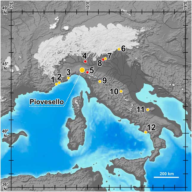
Figure 1 Map of the Alpine region and of the Italian peninsula, showing the Late Pleistocene maximum extent of glaciers (after Ehlers and Gibbard, Reference Ehlers and Gibbard2004) and the continental belts during MIS2 (GIS elaboration based on bathymetric, elevation and WGS84 grid data sourced from: http://www.naturalearthdata.com; Sbrocco, Reference Sbrocco2014; Zickel et al., Reference Zickel, Becker, Verheul, Yener and Willmes2016). The hydrography of the Po plain – Adriatic basin during MIS 2 is from Monegato et al. (Reference Monegato, Ravazzi, Culiberg, Pini, Bavec, Calderoni, Jež and Perego2015). The location of the Piovesello and of the other Gravettian sites cited in the text is shown. 1) Grotte de L’Observatoire cave; 2) Riparo Mochi rockshelter; 3) Grotta delle Arene Candide cave; 4) Casaletto Ceredano pollen record (Ravazzi et al., Reference Ravazzi, Garozzo, Deaddis, De Amicis, Marchetti, Pini, Vezzoli and Zanchi2018); 5) Berceto paleolake pollen record; 6) Grotta Rio Secco cave; 7) Grotta Broion cave; 8) Lake Fimon pollen record; 9) Bilancino; 10) Fonte delle Mattinate; 11) Grotta Paglicci cave; 12) Grotta della Cala and Grotta La Calanca caves.

Figure 2 Digital Terrain Model and simplified geological setting (according to Elter et al., Reference Elter, Ghiselli, Marroni and Ottria1997, with updatings) of the northern watershed of the Mount Ragola-Camolara Massifs. The Gravettian site of Piovesello is shown. The view is from the North.
Piovesello is a hilly area comprised of a varied lithostratigraphic bedrock mosaic. The northern slope of Costa dei Cornini in the Massif of Mount Camolara-Ragola is shaped by ultramafites, massive, hard rocks of Jurassic age (Elter et al., Reference Elter, Ghiselli, Marroni and Ottria1997; Costa et al., Reference Costa, Vescovi and Zanzucchi1990, Fig. 2), but downstream the occurrence of carbonate and pelitic breccias, affected by karst, create a hilly plateau with differential erodibility and topographic complexity. Here, several depressions partly dissected by small creeks, host either accumulations of fine sediments affected by hydromorphic pedofeatures or palustrine basins (Fig. 2 in green). One of them (locally called “Lagasso”) is dammed by a ridge interpreted as a terminal moraine in the most recent State Geological Map 1:50.000 (Elter et al., Reference Elter, Ghiselli, Marroni and Ottria1997). We observed that several other depressions in the immediate surroundings contain only slope and palustrine deposits, thus excluding a glacial cover, even if in the area glacial deposits of late Pleistocene age have been mapped (Elter et al., Reference Elter, Ghiselli, Marroni and Ottria1997). We therefore reconsidered the Quaternary history of this area in the present work (yellow area in Fig. 2). A 2 m-thick sequence of hydromorphic fine sediments filling a small depression, locally called “Piovesello” (Fig. 2) yielded Palaeolithic artifacts. Over 750 (all sizes considered) knapped stones were recovered in 2007 by one of us (F.F.) in primary or subprimary position, embedded in loamy sediments exposed by a seasonally ephemeral creek.
2.2 Modern ecological setting
The modern vegetation of Mount Camolara-Ragola Massif includes mixed broad-leaved, partly cultivated forests (Hornbeam, Hop-Hornbeam, Chestnut, Mountain Maple, Black Alder), scrub growing on ophiolithic rocks (Amelanchier ovalis Medic.) and extensive beech forests up to a climatic timberline of 1700 m asl. A subalpine belt of conifers is missing, despite small, isolated areas of dwarf mountain pine (Pinus mugo/uncinata) that occur in and above the timberline ecotone up to the watershed maximum summits (Alessandrini, Reference Alessandrini1984). The natural timberline is depressed by pastoralism. Petrophytic vegetation on ophiolithic rocks includes several endemics (Saccani and Salvoni, Reference Saccani and Salvoni2015), among which Armeria arenaria subsp. apennina Arrigoni (Arrigoni, Reference Arrigoni2015) deserves a specific mention here, as it occurs in the fossil record of the studied site (see section 7.2).
3 MATERIALS AND METHODS
3.1 Archaeological excavation and field description of the stratigraphic sequence
In 2012 two preliminary field surveys allowed to the identification in the exposed creek gullies of a single layer containing lithic implements and charcoals. After one additional limited survey aimed to collect samples for palaeoenvironmental and chronological purposes, an extensive campaign of excavation took place in summer 2013 (henceforth called “Excavation 2013”) which was aimed to explore the archaeological context (Fig. 3). The pedo-sedimentary succession was exposed along the SW section during the September 2012 fieldwork campaign and all the characteristics were observed along a sample column opened in the central part of the section, which was then further deepened with a 30x30cm sounding until the rocky ophiolite substrate (Figs. 3c and 4).
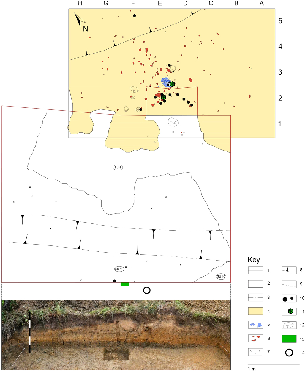
Figure 3 Plan of the excavation with position of the surveyed sectors, the soil samples, core PIOV1 sampled for palaeoecological studies, and the charcoals and lithic artifacts. Below: section SW, exposed during the 2012 survey, with trace of the soil sample column. Key: 1) limit of the excavation; 2) limit of survey 2012; 3) pit exposing SU 10; 4) extent of SU 7; 5) lithic artifacts in SU 7, structure SI; 6) lithic artifacts in SU7; 7) lithic artifacts found on surface during survey 2012; 8) slope edge; 9) stream channel; 10) main charcoals; 11) dated charcoals; 12) stones; 139 soil sample; 14) PIOV1 core a.

Figure 4 Log of the pedo-sedimentary sequence exposed on the SW section in 2012. Stratigraphic units (SU) are reported on the left. Key: 1) bedrock, 2) clay; 3) silt; 4) sand; 5) lithic artifact; 6) gravel; 7) siltstone fragments; 8) ophiolitic granules; 9) charcoal; 10) paraconformity; 11) erosional surface; 12) FeMn concrections; 13) soil micromorphological sample.
The archaeological assemblage was recovered during surface prospecting along the creek bed, during 2012 prospecting and the 2013 archaeological excavation. The latter was carried out in an area of 7.5x9m, subdivided by a base frame of 50x50cm. The excavation of SU 7 was conducted on a smaller area (35m2), with topographic survey of >2cm recovered artifacts, together with the registration of their orientation and immersion. Chunks and other tiny artifacts were recovered by dry sieving (2 mm mesh), except in the area of primary flake concentrations in sq. E2, E3 and E5, where every single artifact was handpicked and the exposed face and the butt position were recorded. The large majority of the artifacts had a horizontal pattern and they were often in association with charcoals. No preserved combustion structures have been unearthed in the excavated zone.
3.2 Geoarchaeological investigation
Field description of the sediment profiles was carried out according to the FAO guidelines (2006). Munsell colors were determined in the field on wet soil. The sequence is described in detail in Table 1. Two undisturbed samples were collected from the SW section exposed during the September 2012 survey (Figs. 3 and 4). Samples include the top of SU 8 and the artefact-bearing assemblage SU 7. Thin sections were produced from undisturbed and oriented monoliths according to the methods presented by Murphy (Reference Murphy1986) and described following the terminology and concepts of Stoops (Reference Stoops2003).
Table 1 Results of thin section description. Notes: 1 TS = Thin Section; 2 US = Stratigraphic Unit; 3 Text = Texture: Cl = Clay; 4 Org = Organic components; ch = presence of charcoal fragments; 5 B-F = B-fabric: PS = porostriated; GS = granostriated; 6 Rel Dist = Related distribution pattern: SSP = single-spaced porphyric; OP = open porphyric; DC Inf = dusty and impure clay infillings; DCC = dusty and impure clay coatings; DC Int = dusty and impure clay intercalations; Abundance of fabric units (by visual estimate): * = 1-2%; ** = 2-5%; *** = >5%.

3.3 Archaeological and petrographic analyses
During the two surveys carried out in September and October 2012, 518 lithic artifacts were recovered, while 249 finds come from the August 2013 excavation campaign. The artifacts considered in the present study total 767, with a module (length + width) greater than 4cm (Table S3) but aiming to a deeper understanding of the technological choices here adopted, a small group of refitted materials deriving from 2007 surveys were also taken into account. Given the presence of a single anthropic context and the absence of dispersed artifacts below and above SU7, all the recovered artifacts are considered for this study as a unique assemblage. However, the lithic implements collected in 2007, which were almost completely excluded from this study do not show any difference in raw material, preservation and morpho-technological features when compared to the material recovered in 2012 and 2013 fieldworks, given their provenance from the same pedostratigraphic context. The artifacts show fresh surfaces over all faces and have sharp edges, although marginal, natural modifications of the unretouched edges affect the 2.5% of the total assemblage and only two pieces are affected by patination.
The conceptual and analytical approach for the study of the lithic assemblage and for the definition of the predetermined blade products was inspired by Inizan et al. (Reference Inizan, Reduron-Ballinger, Roche and Tixier1995). A first effort aimed to identify reduction sequences was based on morpho-technical and morphometric analyses of cores and finished products, as well as on several refitted pieces. The analysis was limited to artifacts longer than 2cm, including all determinable fragments. The analysis of retouched blanks was mainly based on Laplace (Reference Laplace1964), although the different types of retouched blanks have been divided into tools and armatures.
Lithic raw materials were described and grouped on the basis of physical features detected at different magnifications, in order to assess the representation of specific units (LRMU - lithic raw material units) within the lithic assemblages and to define their role in tools production and composition. The microfacies were studied under a stereomicroscope (12 up to 93 magnifications) in the laboratories of the University of Ferrara and were compared to the radiolarite samples gathered from nearby Ligurid outcrops, while chert provenance was determined thanks to the comparative geological collection stored at the Anthropological Museum of Monaco. The palaeontological associations were the key to recognize two distinct provenance areas, related to deep marine and brackish/lacustrine environments respectively.
3.4 Radiocarbon dating
Charcoal sampling for radiocarbon dating was performed directly during the excavation to allow for the effective picking of larger and unweathered charcoal specimens lying directly in contact with the artifacts. Two charcoal fragments > 20mg in weight belonging to Pinus sp. were selected respectively from SU 7 for radiocarbon measurements. Sample LTL13257A was collected during the 2012 survey from a concentration of charcoals. Sample LTL14195A was collected before the 2013 excavation during the opening of a pit in the northern area of the excavation (Fig. 3). Charcoal samples were submitted for 14C-AMS dating at CEDAD, University of Lecce (Italy). They underwent a chemical procedure of alternate Acid/Alkali/Acid treatments. Radiocarbon ages were calibrated with CALIB v. 7.0.4, using the IntCal13 calibration dataset (Reimer et al., Reference Reimer, Bard, Bayliss, Beck, Blackwell, Bronk Ramsey, Buck, Cheng, Edwards and Friedrich2013).
3.5 Palaeoecological analysis of charcoal, pollen and other microbiological particles
Macrobotanical charred remains were found exclusively in SU7. Charcoals were handpicked during the excavation, along with the embedding sediment in order to avoid fragmentation, wrapped in silver foil and sealed in double plastic bags. In addition to stratigraphic information, both location and association with artefacts, if any, were recorded. Twentynine samples thus collected are considered in this study, leading to 59 analysed charcoal fragments (Table S1). Flotation or sieving of the samples was unnecessary, because the charcoals were already isolated during the excavation. Charcoals were cleaned from the embedding sediment in a Petri dish with small quantities of water and left to dry at room temperature. The specimens were then examined with an episcopic microscope (Zeiss Axio Scope A.1 equipped with dark field/bright field illumination system) and a scanning electron microscope (Cambridge Stereoscan 360). Wood atlases (e.g. Schweingruber, Reference Schweingruber1990; Jacquiot et al., Reference Jacquiot, Trenard and Dirol1973) and modern reference collections were used for the botanical identification. When observable, other parameters (e.g. curvature, presence of hyphae, radial cracks) were recorded. However, because of the small dimensions and poor preservation state of the charcoals, these variables were detected on a very limited, non-statistical, number of fragments.
In order to retrieve the complete stratigraphy of the site, a sediment core, 6 cm in diameter, was drilled at the SW section of the 2013 excavation (Fig. 3). The sediment core, named PIOV1, was retrieved with a U-shaped channel, down to a depth of 100 cm. Pollen, micro-charcoal and other microfossils and Loss-On-Ignition were analyzed in the deepest section of the core (60 to 100 cm depth) to obtain information on paleoenvironmental and depositional setting of the area in the interval framing the Gravettian occupation. Twelve palynological samples between 60 - 90 cm depth were processed for palynomorph extraction with repeated HF 39.5% and HCl 10% treatments at 80-90°C, KOH 10%, sieving through a 250 μm mesh, acetolysis and sieving through a 10 μm mesh. Lycopodium spores were added to estimate pollen and charcoal concentrations (Stockmarr, Reference Stockmarr1971). Pollen and other microbiological particles (algae, fern and fungal spores, insect fragments, microscopic charcoal fragments between 10 - 250 μm) were counted in pollen slides at 400x, 630x and 1000x. Reference keys and atlases (Beug, Reference Beug2004; van Geel, Reference Van Geel1978; Punt et al., 1976-Reference Punt, Blackmore, Clarke, Hoen and Stafford2009; Reille, 1992-Reference Reille1998) were used for identification. An additional study of the SEM morphology of pine pollen grains was carried out in one sample extracted from SU7 (see section 4.4). The matrix of this layer consists of a clayey and silty, low-permeability and permanently water-saturated deposit, thus excluding risk of infiltration / contamination by subsequent organic material.
Pollen percentages were based on a sum including trees, shrubs and upland herbs; pollen of local plants of humid habitats is excluded from the main pollen sum. Tilia 2.0.2 (Grimm, Reference Grimm2004) was used to plot stratigraphical diagrams, and then exported into CorelDraw for further modifications (Fig. 6, lower panel). Pollen zonation was obtained by a constrained incremental sum of squares cluster analysis, using the Cavalli-Sforza’s chord distance as dissimilarity coefficient (CONISS, Grimm, Reference Grimm1987). Clustering was restricted to taxa relevant for the ecological interpretation of pollen data. Macroscopic charcoal fragments were extracted from duplicates of pollen samples after soaking in sodium hexametaphosphate and bleach for 24 hours followed by sieving. Sieved fractions (fragments between 125 μm - 1 mm and larger than 1 mm) were analyzed under a stereomicroscope at 6,4x, 16x and 40x to recognize different components (wood charcoal and partially-burnt material). Concentrations (fragments/cm3) of the identified fractions are plotted in Fig. 6, upper panel.
Sediment composition was investigated on core PIOV1 with a LECO® TGA 601 thermogravimetric analyzer on duplicates of pollen samples. Samples were weighed and heated to constant weight at 105°C, 375°, 550°C and 980°C to measure water, non-pyrogenetic organic matter, total organic matter (TOM) + sulphides and the siliciclastic + oxides components, respectively. The carbonate content (+sulphides + sulphates) was determined stoichometrically (Dean, Reference Dean1974). Data are plotted in Fig. 6, upper panel.
Magnetic susceptibility was measured on core PIOV1 with a Bartington MS2 susceptimeter equipped with a MS2E sensor operating on a 2 kHz frequency. Measures were taken every cm, repeated twice and averaged. The curve is plotted in Fig. 6, upper panel.
4 RESULTS
4.1 Field features and micromorphology of the pedo-sedimentary sequence
The succession (Fig. 4) is comprised of three sedimentary bodies with flat-parallel stratification lying on the top of the bedrock: a silty clay complex, a thick layer of silt and coarse sand truncated by a recently-covered erosional surface, and a loamy layer supporting the present-day soils. The limits are abrupt, with angular discordance with the bedrock, and with paraconcordance between the silty clay and the loamy sands, similar to the contact between the latter and the recent upper silts. Each of these main bodies contains further internal lithological differentiations, which are elevated to the rank of stratigraphic units (SU) according to their relevance. SU 1 is dark brown silt with stones lied on granules and frequent subrounded stones covering an erosional surface (SU 2) which truncates SU 3, a light yellowish brownish silt with thin strongly developed laminar structure, medium-sized in the lower part of the unit, small Fe-Mn nodules, uniformly distributed and containing beds of ophiolitic granules. SU 4 is a layer of ophiolitic gravels and granules with particles >2 cm, SU 5 is yellowish-brownish silt with sandy-gravel lenses, small-sized blocky structure, SU 6 is sand with dispersed ophiolitic granules ≥ 2cm in size which lies on a discontinuity surface. SU 7 is gray-brownish clay-silt with medium to large-sized blocky structure. This unit contains the Gravettian lithic artifacts scattered in its lower part and at the interface with SU 8. The latter is sand and poorly sorted gravel interspersed with clay-silt and contains yellowish-brown flat-shaped fragments of siltstone. SU 9 is brownish-gray massive loamy-clay, with medium to large-sized blocky structure, prismatic structure Ø 15cm, with dispersed stones of medium-small size covering SU 10, the bedrock with angular and sub-angular ophiolitic stones.
At micromorphological scale, the examined samples are characterized by massive clay in SU 8 and by an alternating sequence of coarser and finer thin sub-units in SU 7. The coarser intervals are made up by rounded coarse sands and fine gravels supported by a clay-textured matrix. The lithology of the coarser clasts reflects the erosion of the ophiolitic substrate on which the site is located, especially due to the presence of weathered serpentinites, and of some marine sedimentary rocks such as siltstones and claystones (Table 1). The fine-grained sub-units have an almost exclusive clay texture, with few scattered silt and very fine sand-sized grains. This coarse/fine alternating sequence, the roundness of coarse fabric elements and the overall poor sorting suggests that the sediments were derived from surface runoff or small-scale debris flow processes (Bertran and Texier, Reference Bertran and Texier1999). These processes are therefore responsible for the emplacement of the parent material. Post-depositional processes can be grouped under three categories:
(1) Clay illuviation and mechanical clay infiltration. The first can be linked to soil-forming processes acting rather quickly after the deposition of this non-carbonate parent material. This gave rise to a ‘first’ generation of limpid clay coatings, predominantly deformed and reworked in the clay matrix by vertic processes (Fig. 5A - see below). Superimposed on this first episode of pedogenic clay illuviation we observe several layered limpid clay and silty clay coatings and infillings (Fig. 5B-5E). These were derived more likely from intense water percolation through the profile (see Buurman et al., Reference Buurman, Jongmans and PiPujol1998) and, possibly, by topsoil exposure and disturbance (leading to slaking - De Ploey and Mücher, Reference De Ploey and Mücher1981; Boiffin and Bresson, Reference Boiffin and Bresson1987).
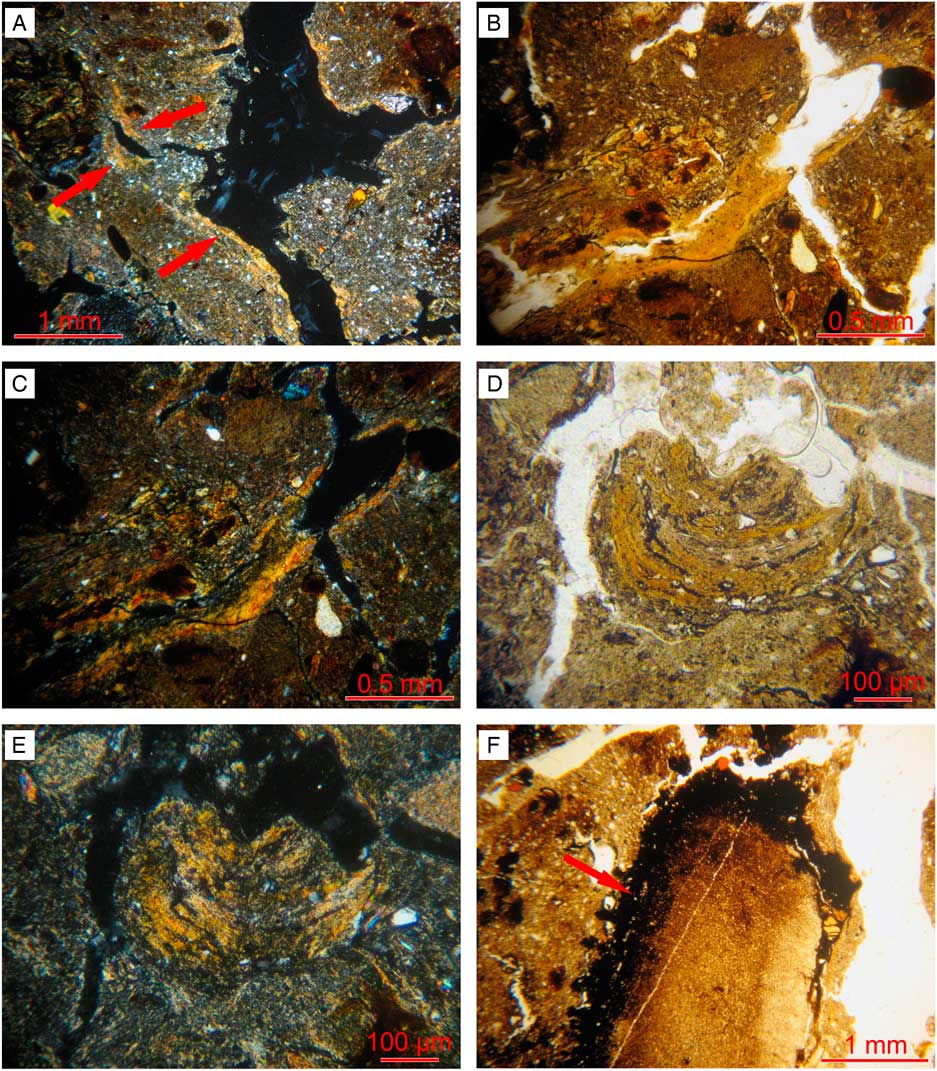
Figure 5 Close-ups of micromorphological features seen in stratigraphic units SU7 and SU8. A) SU7/8medio (middle). Clay coatings reworked by vertic processes along pore walls (arrows). XPL. B-C). SU7/8alto (top). Limpid clay coating with superimposed silty/dusty clay coating. PPL and XPL; D-E) SU7/8medio (middle). Silty clay coating, pertaining to the second ‘generation’ of textural pedofeatures identified. PPL and XPL. F) SU7/8 A. Impregnation of Mn around a coarse rock fragment (arrow). PPL.
(2) Vertic processes. The high clay content (ascribable to the weathering of the ophiolitic substrate) gave rise to shrink-swell mechanisms observed throughout the examined samples. Vertic phenomena are responsible for the poro- and grano-striations, for the deformation of clay coatings along pore walls (see Fig. 5A), for the development of moderate to well separated subangular blocky microstructures, and for the rounding of Mn nodules due to churning.
(3) Hydromorphy. The presence of a perched groundwater table can be inferred from the morphology and arrangement of redoximorphic features in thin section (Lindbo et al., Reference Lindbo, Stolt and Vepraksas2010; see also Stoops and Eswaran, Reference Stoops and Eswaran1985). Reduction took place along pore walls, and oxidation, inside the matrix. The latter process resulted in the formation of alignments of Mn nodules away from the pores in the groundmass (only in the topmost sample SU 7-8Alto Mn coatings, infillings and impregnations around coarser grains are present – see Fig. 5F). Based on this arrangement of reduction and oxidation features we can infer that water saturation took place above the studied units (i.e. a perched groundwater table), most likely in response to their clay texture and consequent low hydraulic conductivity.
Indicators of anthropic activity are scarce at the microscopic scale and no clearly identifiable flaked pieces were observed in thin section, albeit some microcrystalline radiolarite fragments are scattered throughout. A few wood charcoal fragments, often impregnated by Mn, were also observed.
4.2 Reconstruction of the pedo-sedimentary processes
The origin of the Piovesello pedo-sedimentary sequence appears to be the result of a series of medium-low energy colluvial processes involving a modest basin developed on an ophiolitic substrate, which evolved into a regolith of unknown thickness (SU 10). A first phase led to the deposition of silty clay from upstream deposits (SU 9), and it is interrupted by a phase of higher-energy runoff, responsible for the deposition of the gravels in SU 8. This event suggests a destabilization of the morpho-dynamic conditions of the adjacent slopes, presumably due to reduced vegetation cover and a lowered sedimentary basin levels. Lithic industry and charcoal produced by human activities were lying on this erosional surface and subsequently they were both partially embedded in the silty clay composing SU 7. This unit records a restoration of low energy sedimentary conditions which appear not to have disturbed the original distribution pattern of the archaeological materials, as indicated by the sharpness of the flake edges, the widespread presence of tiny (i.e. < 2mm) radiolarite fragments, the lack of rounded fragments of charred wood, the refittings of several artifacts to the cores, almost all performed within a very limited area (see section 6.2). The lenticular geometry of SU 7 was identified during the archaeological excavation and was characterized by a thickening in the central portion of the excavation and by a sparse distribution of lithic artifacts in the margins.
The clear discontinuity that separates SU 7 from the overlying SU 6 records a dramatic change in the stability of the slopes surrounding the basin, as these were subject to intense runoff generating materials at medium energy and leading to the formation of most of the basin fill deposits, approximately 50cm thick. During this phase, alternating episodes of coarse to fine sedimentation occurred, which led to the formation of gravel lenses and coarse sand intercalations (SU 5 to SU 3). It is interpreted that the above lenses reflect limited spreads of coarse material. The discontinuity at the top appears to be related to a phase of historical anthropic interventions in the area, which are responsible for the truncation and the final deposition of silt with pebbles, currently under herb and shrub cover (SU 2 and SU 1).
4.3 Core PIOV1
Overall sediment composition, as depicted by LOI data (Fig. 6, upper panel), is dominated by the fine siliciclastic component + oxides (81-87% of the dry sediment weight), accompanied by TOM+sulphides between 8-12% (dry weight) and carbonates + sulphides + sulphates between 3.5-8% (dry weight). Water content is low (11-21% of the initial weight), in agreement with the low organic matter content, low voids volume and high sediment compaction. No overconsolidation was observed.
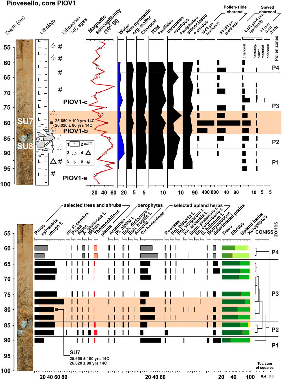
Figure 6 Core PIOV1 (upper panel) - Lithological and selected palaeoecological proxies. Key to the numbers reported in the legend: 1) clayey silt; 2) gravels; 3) deeply weathered pebbles; 4) coated pebble, but without weathering cortex; 5) modern roots; 6) Fe/Mn nodules, coatings. (lower panel) - The record of pollen and other palynomorphs obtained from core PIOV1. The light orange band indicates the core depth interval equivalent to SU7, containing lithic artefacts, as visually identified from stratigraphy available on open sections during the archaeological excavation (Fig. 3).
The lowermost portion of the sequence (PIOV1-a, 100 to 83 cm depth) to be related to the SU 8 of the pedosedimentary sequence exposed in the S section (see paragraph 4.2), is formed by matrix-supported fine gravels, rich in clay and Mn coatings, showing high values of magnetic susceptibility (maximum value = 63, at 93 cm depth) due to the abundance of ultramafic fragments, interpreted as weathered slope deposits.
The following interval PIOV1-b (83 to 77 cm depth), correlated and equivalent to the archaeological layer (SU 7), is a compacted clay soil, displaying vertic and hydromorphic pedofeatures (slickensides, speckles, Mn-nodules and coatings, see section 4.1) and higher content of organic matter due to charcoal micro- and macroparticles (Fig. 6, upper panel). Charcoal enrichment (up to 95 pollen-slide fragments 50-250 μm/cm3 and 10 sieved fragments 125 μm-1 mm/cm3) is related to wood charcoal only and is clearly correlated with human presence, while herb and root tissues are missing, either charred or uncharred. This deposit was formed by deposition of fine mineral material in water-saturated conditions, together with a local human-derived contribution of artifacts and charred particles, and was henceforth affected by strong hydromorphic processes.
The subsequent lithozone (PIOV1-c, 77 to 60 cm depth) is a compacted, mottled clay, sealing the layer including the lithic artefacts. It is the result of fine mineral deposition in a water-saturated environment, though the absence of aquatic and hygrophilous plants in pollen record (see section 4.3) would exclude a permanent open water pool.
4.4 Palynological and LOI record from core PIOV1
Sediments from the PIOV1 core display low pollen concentrations (min. 87 - max. 4098 grains/cm3). Pollen sum varies between 112 - 1063 grains. Pollen grains show different preservation states. Following the nomenclature of Cushing (Reference Cushing1967), they are: degraded (up to 15% of the identified pollen grains); other types of deterioration (corroded, broken, crumpled) are less abundant. This deterioration framework is in agreement with redox processes caused by hydromorphic pedofeatures. However well-preserved pollen grains are still prevailing (>80-90%), allowing us to obtain reliable pollen spectra.
Four pollen zones are distinguished (Fig. 6, lower panel):
- zone P1 (90 - 88 cm depth): Arboreal Pollen (AP) values ca. 30%, mostly Pinus sylvestris/mugo type. Other woody species occur as single/sporadic pollen grains, such as Abies, Ulmus, Corylus, Carpinus betulus, Hedera, Alnus glutinosa type and Betula). The majority of the pollen grains identified belong to upland herbs (mostly Compositae subfam. Cichorioideae). Botryococcus algal colonies occur.
- zone P2 (88 - 83 cm depth): AP between 64-72%, mostly comprised of Pinus sylvestris/mugo. Slightly increasing values of xerophytes, represented by Artemisia, Chenopodiaceae, Ephedra fragilis and distachya types, Plantago alpina type. Botryococcus and Spirogyra occur.
- zone P3 (83 - 63 cm depth): AP between 54 - 81%, mostly comprised of Pinus sylvestris/mugo. Among conifers, all samples record the presence of Pinus cembra, Picea and Abies. Stable and low pollen percentage values of broad-leaved taxa occur. Pollen diversity increases among upland herbs, with the occurrence of four different types of Dipsacaceae, Polygonum bistorta and P. viviparum types, Geraniaceae, Armeria, and several Compositae types (Aster, Anthemis, Centaurea nigra, Cirsium). Pollen of Cyperaceae and Sparganium occur. Algal colonies of Botryococcus are recorded, as well as spores of dung fungi (Sordariaceae and Podospora). This pollen zone registers the highest concentrations of charcoal fragments of the analyzed section (both pollen-slide and sieved charcoal).
- zone P4 (63 - 60 cm depth): AP between 36-46%, mostly comprised of Pinus sylvestris/mugo. Increasing pollen % of broad-leaved taxa (especially Alnus glutinosa type), xerophytes (from 3.9 to 9.4%) and upland herbs. Pollen of Cyperaceae and Sparganium occur, along with Botryococcus colonies.
4.5 Distinguishing Pinus mugo/uncinata from P. sylvestris pollen
Pine pollen is not well preserved at Piovesello. However, observation with a SEM of a few complete fossil pine pollen grains from level 67.5 cm in core PIOV1, following the criteria of Klaus (Reference Klaus1978) confirmed by new observations, allowed the detection of distinct arrangements of tectum sculpture on the grain corpus of fossil pine grains, with chamber caps of equal size and distribution (typical of Pinus sylvestris; see Fig. 7h-i) and chamber caps of unequal size, height and distribution (typical of Pinus mugo/uncinata; see Fig. 7j-k). This suggests that pollen of both Pinus mugo/uncinata (Dwarf Mountain-pine) and P. sylvestris (Scots Pine) pollen (Fig. 7h-k) was trapped in the archaeological layer.
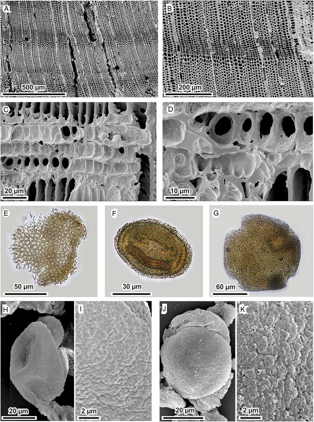
Figure 7 (a-d) SEM pictures of charcoal fragments of Pinus sylvestris/mugo type from sample PIOV13us7E3. a, b) transversal sections; c, d) radial sections with large fenestriform pits in the cross-fields and dentated walls in the ray tracheids; (e-g) optical microscope pictures of fossil pollen grains from core PIOV1. e) Armeria, sample PIOV1 67,5 cm, 400x; f) Scabiosa columbaria type, sample PIOV1 80 cm, 1000x; g) Knautia arvensis type, sample PIOV1 67,5 cm, 400x; (h-k) SEM pictures of fossil Pinus grains from core PIOV1. h-i) Pinus sylvestris, complete grain and detail of the corpus, sample PIOV1 67,5 cm; j-k) Pinus mugo, complete grain and detail of the corpus, sample PIOV1 67,5 cm.
4.6 Anthracology
The charcoals from Piovesello SU7 (Table S1) are subcentimetric in dimension, often poorly preserved, appearing as a thin film adherent to the sediment. Because of the poor preservation state, conservation and visibility of the diagnostic anatomic characters affected the taxonomic level of the determinations. In all instances in which wooden anatomic structures were observable, all analysed charcoals consisted of homoxylous wood (Gymnospermae). For the determination of conifer wood at the genus/species level, observation of the nature of the ray cells is crucial (Schweingruber, Reference Schweingruber1990). In all instances in which the ray anatomy in cross-fields in radial section was observable, it was possible to detect parenchyma cells characterized by fenestriform (window-like) perforations; an anatomic feature characteristic of several species of pines (Pinus sp.). When also ray tracheids were observable, the recognition of cells with dentate inner walls allow to further circumscribe the determination to Pinus sylvestris/mugo type - i.e. in the Italian and European flora Pinus sylvestris, P. mugo, and P. uncinata. We did not detect any Pinus charcoal with smooth inner walls of the ray tracheids, thus we can exclude the presence of Pinus cembra/peuce type. Based on those identification criteria, of the 59 charcoal fragments analyzed 20 are attributed to Pinus sylvestris/mugo type (Scots or Dwarf Mountain Pine; fig. 7 a-d), while for 24 fragments it was possible only an attribution to the genus Pinus sp. (pine). Nine fragments resulted in indeterminate status, lacking any observable anatomic feature; while for 6 fragments it was possible only to reach a generic attribution to conifer wood (Gymnospermae). Hence, the detected variability in the anthracological record is fully explained by differences in the preservation state of the analysed charcoals – reflecting the visibility of anatomic diagnostic characters instead of a taxonomic difference. Thus, the available data suggests a mono-specific character of the charcoal assemblage from Piovesello SU7, in which an exclusive presence of wood charcoals of Scots and/or Dwarf Mountain Pine is strongly suggested.
Besides this taxonomical observation, the rather limited dataset and the poor preservation of the charcoals prevented dendro-metrical and -ecological considerations. However, when observable, charcoals display moderately to strongly curved tree-rings; this feature, together with the presence of reaction wood, may indicate the pertinence of those charcoals to branches (Marguerie and Hunot, Reference Marguerie and Hunot2007). No discernible spatial patterns are observable (Table S1).
5 RADIOCARBON DATING
Radiocarbon ages have been produced from two charcoals of Pinus sp. The oldest (LTL13257A, δ13C (‰) = -25.4±0.5) has been dated to 26020±80 14C BP (2σ calib. interval BP = 29898 – 30681, median probability = 30346 cal yr BP), the youngest (LTL14195A, δ13C (‰) = -23.7±0.5) to 25650±100 14C BP (2σ calib. interval BP = 29443 – 30233, median probability = 29789 cal yr BP). Since no fireplaces were found during the excavation, it can be supposed that natural fires occurred just after or before human frequentation at Piovesello. Moreover, this hypothesis is not consistent with the ecological context of the site, the lack of a reddened soil horizon produced from natural heating (Olive et al., 2017), and the scarcity of firewood in the surroundings, as indicated from pollen data. It is also worth noting that the sediments comprising the archaeological layer are fine minerogenic, preventing any contamination by charcoal unrelated to the artifact deposition (see Fig. 4).
Uncertainties associated to radiocarbon ages are remarkably low, and, consequently, their calibration distribution interval spans less than a thousand years (Fig. 13). These two distributions are statistically different at 95% level (T test 8.34, χ2 = 3.84 at σ = 0.05). We consider that these wood samples originated from old stems and branches of long-lived trees (pines), thus, the observed offset may be related to the effect of old wood (Bowman, Reference Bowman1990), or to a repeated use of the fireplace, or both effects may be combined in the observed offset. Even when the complete range summing up the two ages is adopted (i.e. 29433 – 30681 cal yr BP, 2σ calibration interval) the site falls within the cold stadial phase GS (Greenland Stadial) 5.1 according to the INTIMATE event stratigraphic scheme for the North Atlantic and Europe subcontinent (Rasmussen et al., Reference Rasmussen, Bigler, Blockley, Blunier, Buchardt, Clausen, Cvijanovic, Dahl-Jensen, Johnsen and Fischer2014). However, the short, 150 years-long interstadial GI 5.1, i.e. the rapid, warming event currently dated around 30.65-30.80 ka cal BP (Rasmussen et al., Reference Rasmussen, Bigler, Blockley, Blunier, Buchardt, Clausen, Cvijanovic, Dahl-Jensen, Johnsen and Fischer2014), cannot be ruled out, given residual uncertainties in INTIMATE age-depth model and the limited effort so far placed in dating the Piovesello fireplaces.
6 ARCHAEOLOGICAL EVIDENCE
6.1 Stone tool petrography
Most of the lithic industry was made on local red radiolarite beds belonging to the Monte Alpe Chert formation (Upper Jurassic), representing the sedimentary covers of the external Ligurid ophiolites (Abbate et al., Reference Abbate, Bortolotti and Principi1980; Cortesogno et al., Reference Cortesogno, Galbiati and Principi1987) and widely outcropping along the Apennine watershed at Monte Lama, Monte Menegosa, and Groppo di Gora (Negrino et al., Reference Negrino, Colombo, Cremaschi, Serradimigni, Tozzi and Ghiretti2017). At Piovesello up to 5 different subtypes of radiolarites were flaked (dark reddish, reddish, greenish-reddish, reddish-brown) attesting the exploitation of different varieties of this lithic resource. The cortexes attest that they gathered slabs and blocks from secondary deposits (soils, detritus, local streams). The petrographic features indicate a complete convergence with the local raw material represented by radiolarites interbedded with shales. The selected and flaked blocks are always highly crystalline, in some cases showing complex systems of fractures filled with quarz veins and hydrothermal mineralizations and recrystallizations. The exceptionally highly silified Monte Lama outcrops, situated 9 km east of Piovesello, represent one of the probable exploited area (Fig. 8). Similar outcrops are quite common in the Apennines between eastern Liguria and Emilia (Cortesogno and Gaggero Reference Cortesogno and Gaggero2002; Campana et al., Reference Campana, Martino, Negrino and Del Soldato2013), while different varieties have been surveyed in western Liguria in outcrops of limited extent (Arnasco radiolarites: Negrino et al., Reference Negrino, Colombo, Cremaschi, Serradimigni, Tozzi and Ghiretti2017). Few artefacts were made on cherts from the Calpionella Limestone (Tithonian- Early Cretaceous) lying above the Monte Alpe Cherts radiolarites, which contains few centimetres thick chert layers with medium to low rheological qualities.

Figure 8 A large scale Digital Terrain Model and simplified geological setting of the upper Val Nure on the northern Apennine watershed, showing topographic relationships between the new Gravettian site, the location of the Upper Palaeolithic workshop on Monte Lama ophiolitic sedimentary body, and the Mont Ragola ophiolitic Massif. Notice LGM glacier development on Mont Ragola and widespread landslides (L, light brown).
An allochthonous assemblage includes some chert tools and a bladelet core with end-products and refittable by-products, the biggest elements of which (one side-scraper and one end-scraper, Fig. 9) were obtained from the same chert block (thickness 6-7 cm), with micritic and calcareous whitish cortical zones 1 cm-thick. One artifact shows a rather clean bedding joint, thus suggesting an acquisition in subprimary contexts, very close to the outcrops. These two artifacts were probably introduced on the site as finished tools, while the core shows traces of bladelet reduction sequence carried out on site, since some unmodified end-products and by-products refit on it.
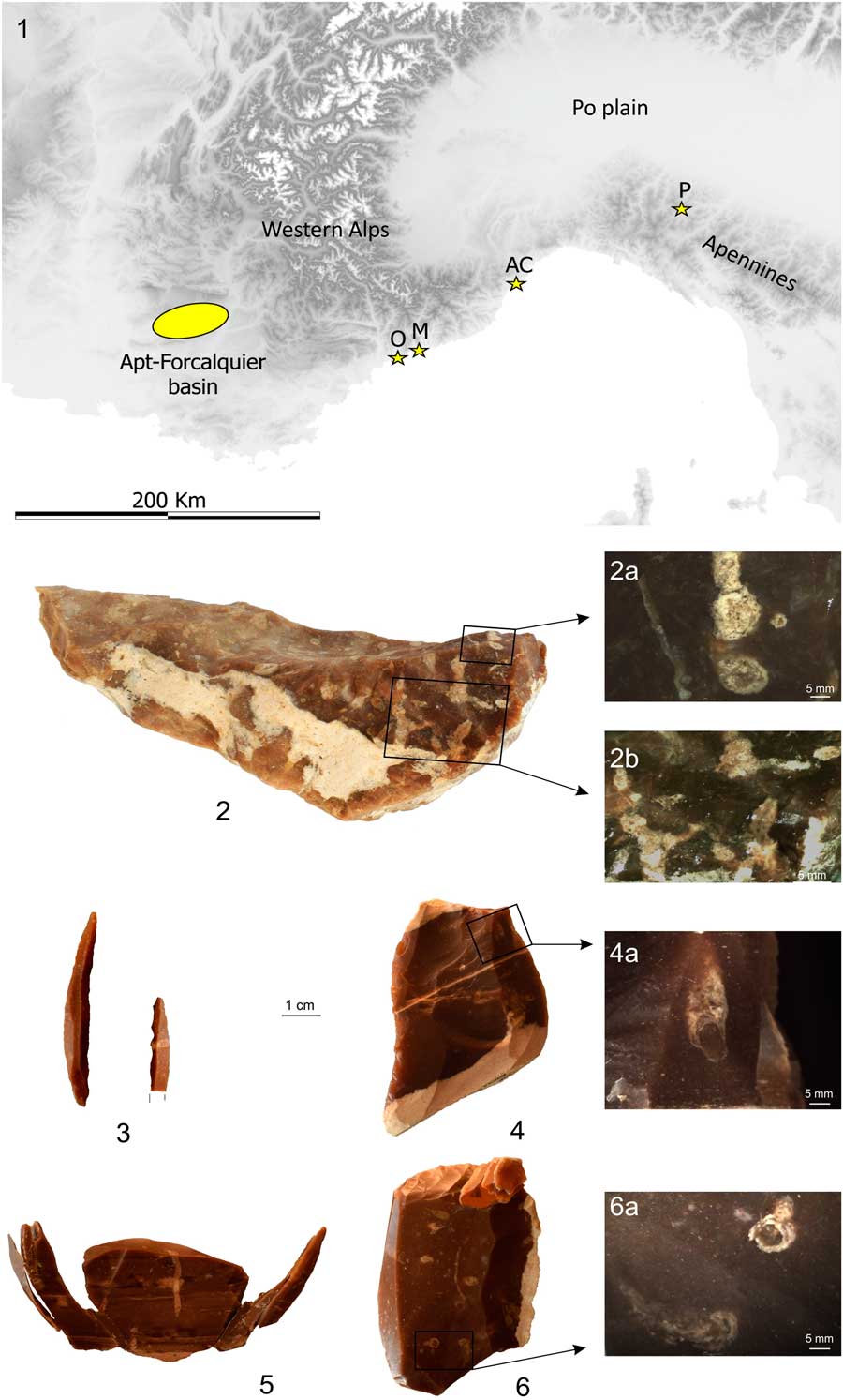
Figure 9 1) Position of the Oligocene Apt-Forcalquier basin (Provence, France). Gravettian sites with cherts from this area are also shown: O) Grotte de l’Observatoire cave; M) Riparo Mochi; AC) Arene Candide cave; P) Piovesello. 2) sample of Apt-Forcalquier lacustrine chert (loc. Pont Julien), collection of the Musée d’Anthropologie Préhistorique de Monaco. 2a, 2b) Well preserved algae structures (Charophyta) in a completely silicified fine texture sediment. Among the bioclasts, ostracods and gastropods are also somewhere represented, all belonging to freshwater environment. 3-6) Piovesello lithic tools made of Apt-Forcalquier Oligocene chert: backed point and fragment (3), lateral scraper (4) and micrograph showing a fragment of algal branch comparable to 2a and 2b (4a), bladelet core with refitted bladelets (5), end-scraper with refitted retouch microflakes (6) and fragments of algal branches comparable to 2a and 2b, in a microlaminated fine texture sediment with microdetrital bioclastic and iron oxides particles (6a).
The raw material is a fine crystalline brown brackish or lacustrine chert with a somewhat thick, whitish and planar micritic calcareous cortex. The paleontological content is represented by several carophyte algae (Charales) thallus and branches often still connected, ostracods and gastropods, all indicating a freshwater environment. The sedimentation took place in a quiet shallow water basin as attested by the finely textured microlaminated sediment enclosing both the microfossils and a few terrigenous grains (Table S2). The provenance of these artifacts is very likely the Oligo-Miocene basin of Apt-Forcalquier (Haute Provence, at least 300 km to the west, Fig. 9), which belongs to the complex of the north prealpine foreland molasse. A close comparison with a large collection of geological samples from the area was carried on in the laboratories of Monaco thanks to the cooperation of one of the authors (P. Simon). In the Apt-Forcalquier basin, chert exposures are localized in several places across a large area showing a certain variability (Slimak et al., Reference Slimak, Bressy, Guendon, Montoya, Ollivier and Renault2005; Tomasso et al., Reference Tomasso, Binder, Martino, Porraz and Simon2016). Close similitudes were detected with samples from Pont Julien (Apt-Bonnieux, Luberon Parc).
6.2 Lithic industry
The largest artifact concentration (Structure I – hereafter SI) was exposed at the base of SU 7. It is an assemblage of radiolarite flakes, articulated in two main concentrations with larger artifacts belonging to the operative chain of a single core, placed below a level indicative of in situ knapping. The northern concentration was characterized by artifacts fanned out across a limited area, while in the southern one the findings appeared more heterogeneously dispersed, and for the most part they were arranged with the dorsal face exposed. Not far from SI, a sediment core was recovered. Except for this concentration, the rest of SU 7 records a variable density of finds ranging between 1/sq and 15/sq, with completely devoid zones towards the periphery.
The composition of the lithic assemblage is reported in Table S3 and the key typological classes of retouched blanks are listed in Table 5. The presence of a rather wide diversity in technological products alongside with many complex refittings (more than 20 pieces each) hints to an on-place exploitation of radiolarite blocks and slabs. Reduction phases, albeit incomplete, are represented by refitted products ranging from core shaping and initialization to full production up to the discard of the residual core. In particular, the stages of core shaping and initialization, as well as the maintenance of the flaking face in more advanced stages, are by far the most represented, comprising 40% of the entire lithic assemblage both from surface collection and from archeological excavation. A good number of products referring to the progressive accomplishment of the laminar knapping (crested, side-crested and core-edge removal blades and core-tablets) shows that the entire lithic waste derived from knapping management exceeds half of the whole lithic assemblage or approximately two-thirds only when considering only the identifiable artifacts. Consequently, complete central blade products are almost completely absent in the lithic assemblage, being present almost only in the form of blade and bladelets fragments, thus suggesting an exportation of the desired products to be used in other zones of the settled area or elsewhere.
Radiolarite slabs were exploited along their maximum length for blade production (e.g. Fig. 10a). Preliminary shaping and longitudinal convexity were maintained through removing orthogonal flakes by hard stone percussion, while the transverse convexities through removal of blades using soft stone percussion. Production of long and rather symmetric blades was carried on with frontal and unipolar sequences using organic percussion. Transverse convexities and recovery of mistakes are maintained by neo-crest blades and seldom using an opposite striking platform, as seen in other Early Gravettian (Digan, Reference Digan2006; Taller and Floss, Reference Taller and Floss2011) and Middle Gravettian (Klaric, Reference Klaric2008) technocomplexes. Another refitted core, reconstructed from the artifacts found in structure SI (Fig. 10b), shows the development of varied technological behaviors, aimed at the production, in first instance, of short blades and later on of bladelets. These products were obtained through the exploitation of adjacent surfaces using the same striking platform thus avoiding the detachment of core tablets. Short blades were also produced from core N.153 (Fig. 10c), probably due to the constrained dimensions of the original block. The core was exploited in an almost entirely unipolar mode and with alternating phases of production and maintenance of the core face and the striking platform which was rejuvenated through the extraction of invasive and thick tablets. The core flaking face was exploited using unipolar removals and only during the final phase of production an opposite striking platform was opened, while lateral convexities were maintained by the removal of thick and partially cortical core-edge flakes.
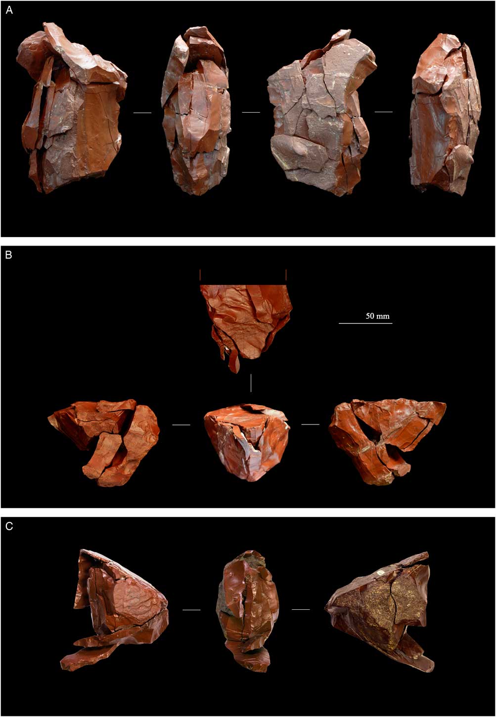
Figure 10 Refitted blade cores from Piovesello made of local red radiolarite (pictures: A. Cocilova, G. Baldelli).
The retouched tools and backed implements are rather scarce (24 elements), both coming from surface collection and SU7. Tools are represented by burins (Fig. 11, n. 1), one end-scraper (Fig. 11, n. 2), scrapers, one splintered piece, and retouched blades. Simple burins and burins on fractures are made on various supports (thin flakes, laminar pieces, maintenance and cortical flakes) and show one or more long burin spalls. Burin-cores are made on thicker blanks and shares with maintenance and core-edge removal flakes the same width range (13-17mm).
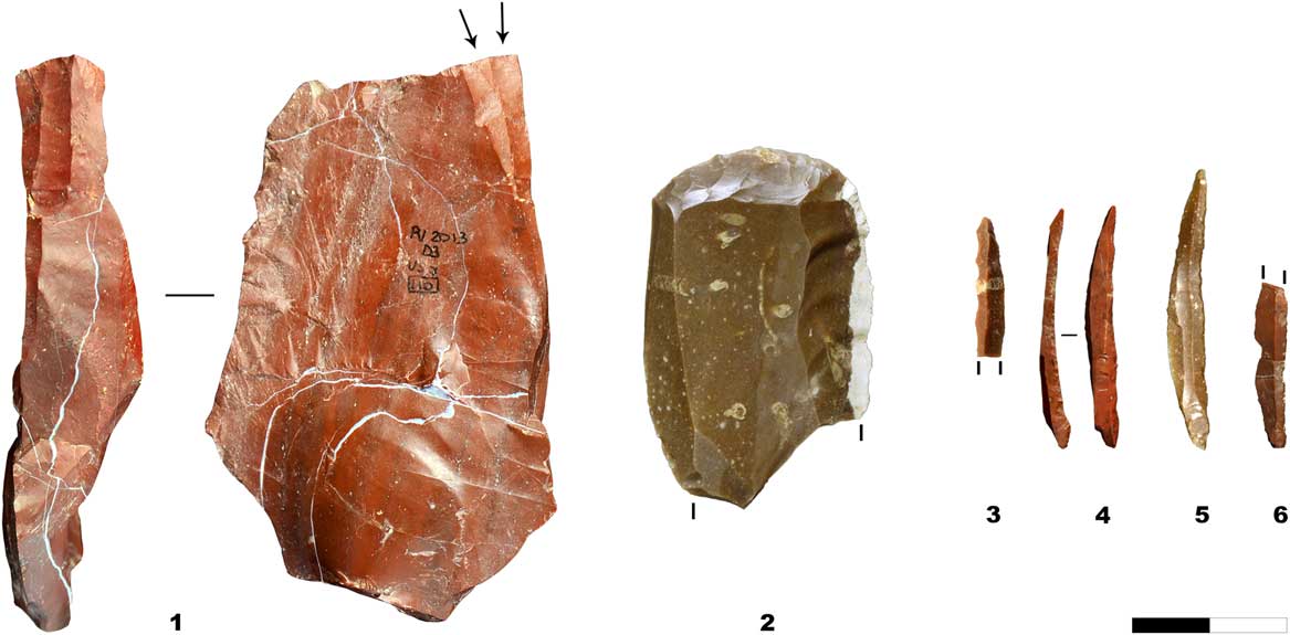
Figure 11 The retouched lithic assemblage from SU7; 1) fracture burin; 2) end-scraper; 3) fragmented backed point; 4-5) marginally retouched backed points; 6) fragmented backed bladelet (pictures: A. Cocilova, G. Baldelli).
Backed points and backed bladelets complete and fragmented have been made from full production bladelets (Fig. 11 and Table S4). Backed points are intact and have invasive (Fig. 11, n. 3) or marginal back (Fig. 11, ns. 4,5) opposed to unretouched margins and additional retouches on the base, while backed bladelets (or points) are all fragmentary (Fig. 11, n. 6). A projectile point has been made on a burin spall. The size of the armatures is in agreement with the bladelet production: length 32-39mm, width 4-5mm, and thickness 2mm.
7 DISCUSSION
7.1 The terrestrial ecosystems of the northern Apennine at 30 ka and evidence of Gravettian human interaction at Piovesello
The availability of both microscopic plant remains and wood charcoal from a mountain site with traces of anthropic presence dating to the last glacial provides a chance to obtain unprecedented insights about terrestrial ecosystems and human activities on the northern Apennine watershed at around 30 ka ago. This is due both to sealing by water-saturated clayey deposits, allowing for pollen preservation, and to the occurrence of charcoal, allowing us to obtain 14C ages.
The identification of terrestrial habitats relies on the occurrence of high pollen producers from steppe and semidesert environments, like Poaceae, Artemisia, Ephedra fragilis and E. distachya types, but also on the occurrence of low pollen producers, which help in reconstructing the habitats near the archaeological site. This second group includes indicators of petrophytic desert - like Armeria (Fig. 7e) and Dipsacus fullonum type – and indicators of mountain steppe (Walter and Breckle, Reference Walter and Breckle1986), such as Plantago alpina type (including widespread species typical for Alpine and Apennine steppe - P. serpentina and P. alpina), Succisa pratensis type, Knautia arvensis type and Scabiosa columbaria type (these latter in Fig. 7f-g). These two indicator groups suggest that the dominant vegetation in the proximity of the site was an open petrophytic semi-desert characterized by both (i) orophilous, xeromorphic, basic-adapted vegetation occupying poorly developed soils on bedrock outcrops or regolith, and (ii) discontinuous mountain steppe on fine-grained substrates. The modern habitat of Plantago serpentina, P. alpina, as well as most of the European species of Armeria and Scabiosa encompasses garrigues, modern grassland steppes and semideserts in the Eurasian mountains and plateaux (Arrigoni et al., Reference Arrigoni, Ricceri and Mazzanti1983; Chiarucci et al., Reference Chiarucci, Foggi and Selvi1995; Horvat et al., Reference Horvat, Glavac and Ellenberg1974; Archibold, Reference Archibold1995; Walter and Breckle, Reference Walter and Breckle1986).
In the modern pollen-vegetation calibration dataset of the Alps (Davis et al., Reference Davis, Zanon, Collins, Mauri, Bakker, Barboni, Barthelmes, Beaudouin, Birks and Bjune2013; Furlanetto et al., Reference Furlanetto, Ravazzi, Badino, Brunetti, Champvillair and Maggisubmitted; Van der Knapp et al., Reference van der Knaap, van Leeuwen and Ammann2001), an arboreal pollen around 50% with very low concentration and pollen accumulation rate values is characteristic for sites at or above the timberline altitude, which also receive pollen from lower vegetation belts transported by convective air masses (Van der Knaap et al., Reference van der Knaap, van Leeuwen and Ammann2001; Pini et al., Reference Pini, Badino, Brunetti, Champvillair, Vallè, Ravazzi and De Amicis2017a; Badino et al., Reference Badino, Ravazzi, Vallè, Pini, Aceti, Brunetti, Champvillair, Maggi, Maspero, Perego and Orombelli2018). These pine pollen proportions are similar to those reported in a nearby pollen record from palaeolake Berceto (870 m a.s.l., Bertoldi et al., 2004, Reference Bertoldi, Chelli, Roma and Tellini2007, Fig. 1), with absence of woody plant macrofossils, and it was also likely located over the timberline during late MIS 3 and MIS 2. Furthermore, although runoff activity would have conveyed needles and other light organic particles from existing trees and shrub individuals to the Piovesello depression, the absence of stomata and of conifer periderms corroborates the idea that conifers did not grow in the vicinity of the site. The occurrence of pine charcoal in the single level SU7 at Piovesello appears to be clearly related to human activity instead of runoff and other processes related to slope movements (compare Figs. 6, upper panel and 12; see section 4.2). These data suggest that pines were locally absent in the study area which was above the timberline, while wood/charcoal was collected according to its abundance and carried to the site by humans together with other raw materials. Pine pollen is not well preserved at Piovesello, but SEM observation suggests occurrence of both Pinus mugo/uncinata (Dwarf Mountain pine) and P. sylvestris (Scots Pine) pollen (section 4.4). Dwarf Mountain pine is able to grow much higher than any other European pines above the timberline formed by the open forest, e.g. on warm southern aspects, as it occurs today in the Pinus mugo-timberline ecotone of Eastern Alps, in the Central Apennine and in other high Mediterranean and Balkanic and Carpathian Mountains (Ballian et al., Reference Ballian, Ravazzi, De Rigo and Caudullo2016). Thus, we cannot exclude the occurrence of sporadic, low density dwarf pines, likely on the southern slopes of the Monte Ragola-Camolara Massif, but most probably not in the immediate surroundings of the Piovesello small depression, or out of the runoff watershed. This observation accords with the modern biogeography of Pinus mugo/uncinata in the Northern Apennine, which maintains a few isolated living populations, including Monte Nero – M. Ragola (Alessandrini, Reference Alessandrini1984) close to the Piovesello site (see Fig. 8).
7.2 Implications for the historical biogeography of petrophytic plants in the northern Apennine
The find of Armeria fossil pollen in the sediment unit bearing human artifacts is of interest for the historical biogeography of the altitudinal open ecosystems in the N-Apennine. The actual living species in the region (A. arenaria subsp. apennina Arrigoni) is an endemic of the northern Apennines limited to petrophytic ecosystems on ultramafic rocks, either in the mountains and in the altitudinal belts (Chiarucci et al., Reference Chiarucci, Foggi and Selvi1995; Arrigoni, Reference Arrigoni2015), while our late Pleistocene fossil record is located in a gently sloping area which supported beech and fir forest until recent reclaiming (see modern vegetation in section 2.1.). The current distribution of Armeria in the northern Apennines may be seen as the result of a late Holocene expansion of the petrophytic ecosystems related to climate cooling and human-shaped pastures (Pini et al., Reference Pini, Ravazzi, Raiteri, Guerreschi, Castellano and Comolli2017b). However, these events occurred after an early Holocene forest rise causing a severe bottleneck for altitudinal plants in the low-altitudes of the northern Apennine chain. Our fossil data in turn provide evidence for a semidesert belt which likely persisted for a long time at 870 m a.s.l. during the last glaciation, including extensive habitats for petrophytic plants. Therefore, according to our data, the modern populations of Armeria arenaria subsp. apennina represent an orographic relict from larger occurrences in the last glaciation, regardless of glacier activity in the northern Apennine (see below). On the other hand, maximum refugial patterns are expected in the early Holocene phase of thermal maximum (Renssen et al., Reference Renssen, Seppä, Crosta, Goosse and Roche2012).
7.3 The paleoclimatic setting of the Piovesello site during Greenland Stadial 5
The occupation phase recognized at Piovesello in SU7 can be correlated on the basis of radiocarbon dates with the Greenland Stadial 5.1 of the recently revised GICC05 chronology of Northern Atlantic – European subcontinent (Rasmussen et al., Reference Rasmussen, Bigler, Blockley, Blunier, Buchardt, Clausen, Cvijanovic, Dahl-Jensen, Johnsen and Fischer2014) (Fig. 12), which is identified as one of the most pronounced cold spells with a high dust flux in Greenland ice sheet (Fig. 12). GS5 pre-dates the onset of the last glacial maximum in the Alps as it is currently understood (Monegato et al., Reference Monegato, Scardia, Hajdas, Rizzini and Piccin2017; see S. Margherita Stade in Fig. 12) and the culminations of the Boreal hemisphere major ice-sheets (Hughes et al., Reference Hughues, Carpenter, Rockström, Scheffer and Walker2013). Although major alpine valleys were glaciated as early as 32-33 ka cal BP (Spötl et al., Reference Spötl, Reimer, Starnberger and Reimer2013), glaciers draining the Italian side of the Alps reached their outermost piedemontane lobes (e.g. Garda and Tagliamento glaciers in Fig. 12) only after 28 ka BP. The valley glaciers developed on the northernmost watershed of the Northern Apennine may have reached a maximum extent between 29 and 27 cal ka BP, prior to the Alpine last glacial maximum, during the so-called Campo Imperatore Stade (see Giraudi, Reference Giraudi2015 and Fig. 12). Given these constraints, and the position of the Piovesello site which is located about 600 m from a ridge, possibly of morainic origin (site of Lagasso, see Fig. 2), we cannot exclude that human activities took place above the timberline in a semidesert vegetation, bounding the fronts of local glaciers at their maximum expansion. However, the Lagasso front moraine is currently undated and its deposition may not be in phase with the Alpine maximum.

Figure 12 The chrono-climatic setting of the Piovesello site compared with hemisphaeric, Alpine and Apennine climate proxies. Panel A – Lake pollen records as summarized by % of woody plants (Lake Fimon and Tenaghi Philippon), from Wick (Reference Wick2000), Pini et al. (Reference Pini, Ravazzi and Reimer2010), Muller et al. (Reference Müller, Pross, Tzedakis, Gamble, Kotthoff, Schmiedl, Wulf and Christanis2011); Panel B – Greenland ice core INTIMATE chronology from Rasmussen et al. (Reference Rasmussen, Bigler, Blockley, Blunier, Buchardt, Clausen, Cvijanovic, Dahl-Jensen, Johnsen and Fischer2014); Panel C – North Atlantic Heinrich Events; Panel D – Delta 18O record from speletheme 7H, Bernese Alps, from Luetscher et al. (Reference Lüetscher, Boch, Sodemann, Spötl, Cheng, Edwards, Frisia, Hof and Müller2015); Panel E – Glacier advances in the Apennines from Giraudi (Reference Giraudi2015); Panel F – Glacier advances of two major glaciers in their pedemontane moraine systems, eastern Italian Alps (Garda and Tagliamento glaciers); the distance from the valley outlet is shown in km, modified from Monegato et al. (Reference Monegato, Scardia, Hajdas, Rizzini and Piccin2017).
The forest cover of the Po Plain in this time span is recorded in the AP (arboreal pollen) from the Lake Fimon record in the south-eastern Italian foreland (Wick, Reference Wick2000; Monegato et al., Reference Monegato, Pini, Ravazzi, Reimer and Wick2011; Ravazzi et al., in prep., Fig. 1 and 12, panel A) and the Casaletto Ceredano site (Ravazzi et al., Reference Ravazzi, Deaddis, De Amicis, Marchetti, Vezzoli and Zanchi2012; Deaddis et al., Reference Deaddis, Garozzo, Cherubini, Croce, De Amicis, Gärtner, Lonelli, Maggi, Pini, Ravazzi and Schneider2017, Fig. 1). The Po Plain was extensively covered by mixed boreal forests during the whole span of MIS 3. The thermal timberline is estimated at around 700 m a.s.l. (Ravazzi et al., Reference Ravazzi, Orombelli and Tanzi2004). A forest withdrawal in northern Italy occurred at the onset of Heinrich Event 2, 27.5 cal ka BP (Fig. 12), in phase with the maximum of Alpine glaciers (Monegato et al., 2007, Reference Monegato, Scardia, Hajdas, Rizzini and Piccin2017) and with a marked lightening in the 7H cave speleothem isotopic record in the Alps (Lüetscher et al., Reference Lüetscher, Boch, Sodemann, Spötl, Cheng, Edwards, Frisia, Hof and Müller2015). The occupation phase at Piovesello not only pre-dates Heinrich Event 2, but also Greenland Interstadial 4 and 3 peaks, the latter bounding the end of Greenland Stadial 5.1 (Fig. 12). We conclude that the Po Plain was still forested at the time of the Piovesello occupation phase. Regional records estimate a timberline altitude not reaching the Piovesello location, corroborating the results of the palaeoecological study carried out on the archeological layer.
Cold to harsh climatic conditions have also been detected in cave and rock shelter deposits along the western Ligurian arch; respectively at Arene Candide and Mochi. At Arene Candide, micromorphological analyses consistently suggest that very cold and (semi)-arid periglacial environments bounded very reduced (unit B) up to absent (unit C) human traces between 32 and 28 cal ka BP. The data are consistent with a cooling trend marked by an abrupt increase of cold conditions inferred from both avifaunal (Cassoli, Reference Cassoli1980) and macromammal associations (Cassoli and Tagliacozzo, Reference Cassoli and Tagliacozzo1994). Unit C thus reflects a phase of arid and cold climate (ca. 31.2-32.0 ka cal B.P.) which has to be correlated with Heinrich Event 3 (Rellini et al., Reference Rellini, Firpo, Martino, Riel-Salvatore and Maggi2013). The chronology of the basal part of unit B is framed between 30.0-30.1 ka cal BP and partly matches the Piovesello time span, which is rather positioned in GS-5.1, the colder spell of GS5, which correlates to the more recent portion of HE3 (Fig. 12). The effects of Heinrich Event 3 on rock shelter deposits have also been suggested for the portion just below the middle part of unit D at Riparo Mochi, in the Balzi Rossi cliff. Here again, the faunal assemblage agrees with this assessment of cold and dry conditions and prevalence of Alpine grasslands in the middle parts of unit D (Tagliacozzo et al., Reference Tagliacozzo, Zeppieri, Fiore, Spinapolice and Del Lucchese2011), leading to consider that unit E may correspond to the return to cold stadial conditions during GS5. Unit F, on the other hand, does not contain sufficient elements to distinguish traces of D/O cycles in it (Douka et al., Reference Douka, Grimaldi, Boschian, del Lucchese and Higham2012; Tagliacozzo et al., Reference Tagliacozzo, Zeppieri, Fiore, Spinapolice and Del Lucchese2011).
7.4 The Piovesello cultural setting framed in the Early Gravettian phase
The Piovesello lithic assemblage is culturally homogeneous and its attribution to the Gravettian lies mainly on the broad technological and typological features recorded, despite the low number of tools and backed pieces. Burins and end-scrapers are a basic component of the common domestic Gravettian tool-sets, in addition to scrapers made on flakes and splintered pieces, as has been described in other contexts in central Southern Europe (Palma di Cesnola, Reference Palma di Cesnola1993). Although end-scrapers were almost systematically made on regular blades, the Gravettian is also known for the vast array of burin types (simple, on fracture and on retouch) which were realized on a range of blanks and are considered as diagnostic elements of specific cultural facies diffused in a short time-span at regional or supra-regional scale across Europe during the Middle Gravettian. This latter is the case of the Raysse–type and the Noailles–type burins; the first spread across a large area in western France where it follows the Noailles Gravettian facies in stratified sequences (Klaric, Reference Klaric2008). This specific artefact is made on blades with faceted longitudinal burin spalls and it looks different than the burins on fracture recovered at Piovesello. The Noailles burin type spreads at supra-regional scale from Spain (Bernaldo de Quiros et al., Reference Bernaldo de Quirós, Maíllo-Fernández, Castaños and Neira2015) to southwestern France and to the Tyrrhenian coast of Italy (Palma di Cesnola, Reference Palma di Cesnola1993) where its appearance is recorded at Riparo Mochi layer D (spits f3.5-1; f2; fl; f) at 29.4-28.5 ka cal BP (Douka et al., Reference Douka, Grimaldi, Boschian, del Lucchese and Higham2012) and at the open-air site of Bilancino on the western slope of the Central Apennine at 28.6-28.0 ka cal BP (Aranguren and Revedin, Eds, Reference Aranguren and Revedin2008). Raw material acquisition strategies at Bilancino (Aranguren et al., Reference Aranguren, Cavulli, D’Orazio, Grimaldi, Longo, Revedin and Santaniello2015) show a rather wide exploited territory which spans from the central Tyrrhenian coasts to the central portion of the Apennines, towards Umbria or Marche region, where the flint outcrops which provided at least 50% of the chipped stone assemblage at the site were located (Aranguren et al., Reference Aranguren, Cavulli, D’Orazio, Grimaldi, Longo, Revedin and Santaniello2015, p.445) and thus suggesting a well-established itinerary which crossed this mountainous chain. At the moment, this is the only indication of the presence of Noailles Gravettian east of the Apennine chain, but it is completely absent in Adriatic Italy (Gambassini, Reference Gambassini2007), in the whole Balkan region (Mihailovic and Mihalovic, Reference Mihailovic and Mihailovic2007) and Greece (Adam, Reference Adam2007). The available radiocarbon datings from Piovesello constrain the phase of human occupation between 30.7 and 29.4 ka cal BP (complete 2σ calibration interval), thus slightly preceding the appearance of the Noailles Gravettian (Fig. 13). Piovesello laminar reduction sequences share few common traits with Bilancino, where in-depth analyses of refitted cores allowed drawing a first picture of Evolved Gravettian lithic technology in the Italian peninsula (Grimaldi et al., Reference Grimaldi, Aranguren, Revedin, Gottardi and Cavulli2011), while there are some key differences which does not allow for a strict comparison of the two sites. At Bilancino laminar cores on allochthonous raw materials shows generally three striking platform and thus an advanced degree of reduction; the flaking angle is perpendicular or slightly tilted and the progression of the reduction sequences is carried on with bidirectional exploitation, while at Piovesello one striking platform is generally used, the flaking angle is rather steep (at least in bladelet cores with volumes comparable to the Bilancino ones) and the production is always unidirectional, while a second striking platform is only used during maintenance phases. Furthermore, in the Tuscan site some specific choices for lamellar production clearly mark a difference with Piovesello: narrow bladelets are produced using the débitage sur tranche d’éclat after a mesial fracture of the support and very often core-edge removal flake-blades invade the flaking surface, while at Piovesello only burin-cores are testified and lateral flakes or blades are used to maintain lateral convexities during a full frontal reduction sequence. Although the already stated different technological choices it is nonetheless to be remembered that Bilancino is a specialized site (Aranguren and Revedin, Eds, Reference Aranguren and Revedin2008) and its peculiar reduction sequences may bias the general frame.

Figure 13 Available early to middle Gravettian radiocarbon dates of the Italian Peninsula (this study; Aranguren and Revedin (Eds.), Reference Aranguren and Revedin2008; Boscato et al., Reference Boscato, Ronchitelli and Wierer1997; Douka et al., Reference Douka, Grimaldi, Boschian, del Lucchese and Higham2012; Palma di Cesnola, Reference Palma di Cesnola2004; Rellini et al., Reference Rellini, Firpo, Martino, Riel-Salvatore and Maggi2013) were calibrated using the IntCal13 curve (Reimer et al., Reference Reimer, Bard, Bayliss, Beck, Blackwell, Bronk Ramsey, Buck, Cheng, Edwards and Friedrich2013) on OxCal v. 4.3 (Bronk Ramsey, 2017).
Given the relative scarcity of lithic analysis of Middle Gravettian assemblages in the Italian peninsula, when widening the comparison to the Western Mediterranean area, a consideration of French Noaillian assemblages and their relative reduction sequences (e.g. Brassempouy: Klaric, Reference Klaric2008) shows some common points with Piovesello lithic technology. Shared common traits are unipolar exploitation for laminar production and the utilization of an opposite striking platform for maintenance purposes, a frontal progression of lithic production and the transversal convexities managed to obtain a rather narrow flaking surface. These characters which allow comparison of Piovesello to French Noaillan assemblages are nonetheless shared even by Early Gravettian assemblages in Italy and in other Western Europe areas (Wierer, Reference Wierer2013). All these considerations, together with the absence of Noailles burins, thus point to an attribution of this site to a late phase of Early Gravettian.
Backed implements are another diagnostic trait of the Gravettian and their typological features were used for its tripartite subdivision of Gravettian (Early, Middle and Late), being the first phase characterized both by invasive and by the occurrence of marginally backed points. Among these latter, a specific type, the fléchette point, a leaf-shaped point characterized by marginal semi-abrupt retouch, sometimes inverse, at one or both ends of the blade blank, is rather typical for the Early Gravettian (Pesesse, Reference Pesesse2008), but currently it is completely absent at Piovesello. The Gravettian is also typified from the invasive Gravette-type backed points and the Vachon points (Simonet, Reference Simonet2011). However, none of these pieces has been recovered at Piovesello except for very few fragmentary invasive backed bladelets which can be classified as micro-Gravette points (Fig. 11, n. 3). Most of the backed points at Piovesello have shallow abrupt retouches, are non invasive, made on regular straight bladelet in a way closely comparable to implements discovered in few earliest Gravettian assemblages. Similar products have been reported along the Southern Tyrrhenian coast at Grotta della Cala, where the earliest appearance of the Gravettian is testified by the marginally retouched points recovered in spit 3m which is overlaid by spit 3d dated to 31.9-31.2 cal ka BP and from spit 1m dated to 31.6-30.8 cal ka BP (Boscato et al., Reference Boscato, Ronchitelli and Wierer1997). A closer Gravettian complex which might offer further hints for the interpretation of the Piovesello lithic assemblage is the aforementioned Riparo Mochi in the Western Ligurian coast (Laplace, Reference Laplace1977). Here, layer F records an evolved Aurignacian phase dating to around 33 ka in the lower portion of the layer and a low-frequency human occupation phase in the upper part (spits 40-34), dated to 31.0-29.7 cal ka BP based on shells and charcoal, and possibly referred to an initial Early Gravettian. The dating from the overlying layer E (30.2-29.5 cal ka BP) is in good agreement with Piovesello, but this context, tentatively attributed to the early Gravettian, is unfortunately characterized only by rare artefacts and a small hearth, identified during the 20th century excavations (Douka et al., Reference Douka, Grimaldi, Boschian, del Lucchese and Higham2012). Similar observations may be proposed for the Ligurian site of Arene Candide, which yielded a thick Gravettian sequence with dating of Unit B (Rellini et al., Reference Rellini, Firpo, Martino, Riel-Salvatore and Maggi2013) bracketed between 27.8-31.0 cal ka BP, thus coherent with Piovesello, but again almost completely devoid of any anthropic trace, both in the older (Bietti and Molari, Reference Bietti and Molari1994) and in the recent excavations (Martino, unpublished data), where just over 20 elements were recovered.
In a broader perspective, the Piovesello assemblage could be thus ascribed to Early Gravettian (“Undifferentiated” or “Gravettian with backed points”; Laplace, 1966, Reference Laplace1977; Palma di Cesnola, Reference Palma di Cesnola1993, Reference Palma2006), a technocultural facies present in the whole Italian peninsula, prior to the differentiation between Adriatic and Tyrrhenian areas which characterize the middle Gravettian (Palma di Cesnola, Reference Palma di Cesnola1993; Gambassini, Reference Gambassini2007). This specific facies is testified mostly on chronometric than cultural base at Riparo Mochi layers F and E and Caverna delle Arene Candide in the lower portion of unit B (layer P10), at Grotta della Cala atrio-GB (e.g. layers 3m, 3d, 2, 1m and 1d), at Grotta della Calanca (lower level) and, on the other side of the Apennines, at Grotta Paglicci (levels 23C-A; level 23A dates to 33.0-32.2 cal ka BP, level 22F-B to 33.2-32.3 cal ka BP, level 22A to 31.8-31.1 cal ka BP), all characterized by an elevated incidence of backed points and by other typological and morphometrical indexes, despite marked differences have been reported among these sites (Boscato et al., Reference Boscato, Ronchitelli and Wierer1997).
7.5 The regional physical setting and the production and circulation of radiolarite and flint artifacts
The Piovesello site is just 9 km from the large lithic Mousterian and Aurignacian workshops recently described from Monte Lama (Fig. 8, Negrino et al., Reference Negrino, Colombo, Cremaschi, Serradimigni, Tozzi and Ghiretti2017), where thousands, if not tens of thousands, of radiolarite artefacts were collected. The Monte Lama - Prarbera Complex is the largest ophiolitic sedimentary body on the northern Apennine watershed (Bernini et al., Reference Bernini, Tellini, Vescovi and Zanzucchi1990) and includes at the top a thick portion of red radiolarite (with bluish varieties). The intense frequentation of Mt. Lama is linked to the presence of high-quality, strong vitreous raw material, suitable for the production of broad flakes as well as long blades. These raw materials were found up to 100 km west of the primary source, in the Aurignacian layers of Riparo Mochi and Riparo Bombrini in Western Liguria (Negrino and Starnini, Reference Negrino and Starnini2006; Negrino et al., Reference Negrino, Colombo, Cremaschi, Serradimigni, Tozzi and Ghiretti2017) and in coeval levels at the Grotte de l’Observatoire (Porraz et al., Reference Porraz, Simon and Pasquini2010) in Eastern Provence.
There are no radiolarite outcrops in the ultramafic masses of the Mount Ragola - Mount Nero, thus it is possible to conclude that the Piovesello radiolarite assemblage originated from Mount Lama. The ridge connecting Mount Lama to Piovesello has been extensively affected by slope activity during the last 30 ka (Fig. 8, areas in light brown), most probably triggered by intense fluvioglacial erosion connected to the last glacial lowstand and low fluvial baseline of the Nure and Ceno Rivers. This severe erosion dismantled ancient plateau and removed the Paleolithic deposits, remaining strips being preserved by massive ultramafic rocks at Mount Lama and in the Mount Ragola – Mount Nero ultramafic Massifs, but only outside of the glaciated area. From a geomorphic perspective, we therefore interpret our Paleolithic finds as the relicts of a late Pleistocene scattering over ancient highlands and subsequent dismantling. Last glacial maximum to Holocene fluvioglacial entrenchment and landsliding may have limited site visibility, and/or discouraged subsequent Paleolithic frequentation of the area.
An estimation of the degree of human frequentation around the wetlands of Lagasso-Piovesello and this part of the Apennine watershed seems problematic due to the aforementioned reasons. Moreover, it is also possible that extensive excavations might circumscribe the entire Piovesello settled area, thus allowing for the reconstruction of its inner spatial organization and for a deeper understanding of the site functions, since the current lithic scatters do not provide evidence for long-term use of this area. Low density of archaeological materials suggesting very ephemeral to short-term human presence during the early Gravettian is a shared feature with other sites in Italy. The actual archaeological evidence leaves at the moment some unanswered questions related to the effectiveness of such a scanty human presence which has to be tested against different variables such as subsistence modalities, mobility degrees, raw material procurement choices and settlement strategies to explain which concurrent factor may be involved. A context comparable to Piovesello has been reconstructed from geoarchaeological investigation on the Marche Apennine watershed, at Fonte delle Mattinate (770 m a.s.l.), where evidence of early Gravettian frequentation has been related to the interval between GI-5 and the HE3 (Giaccio et al., Reference Giaccio, Rolfo, Galadini, Messina, Silvestrini and Sposato2004; Silvestrini et al., Reference Silvestrini, Peresani and Muratori2005). In Liguria, at Riparo Mochi, the upper cuts of layer F and layer E, comprised between F42-41 and D28, testify to several episodes of very short and/or limited occupation episodes, bracketed by very short and/or periodical events of abandonment of the site (Douka et al., Reference Douka, Grimaldi, Boschian, del Lucchese and Higham2012). Comparably, Arene Candide cave has also produced very low density of artifacts in unit B, similarly to three caves in the northern area of the Veneto-Friulian plain. At Grotta del Broion, very few common tools, fragmented gravettes and ornamental beads from layer E were dated to 30.5-28.8 cal yr BP (Broglio and Improta, Reference Broglio and Improta1995). Grotta del Rio Secco yielded a modest assemblage from macro-unit BR1 composed of finished tools and backed bladelets associated to rare cut-marked caprid and marmot bones (Peresani et al., Reference Peresani, Romandini, Duches, Jéquier, Nannini, Pastoors, Picin, Schmidt, Vaquero and Weniger2014) and to charred wood dated to 33.4-30.0 cal ka BP (Talamo et al., Reference Talamo, Peresani, Romandini, Duches, Jéquier, Nannini, Pastoors, Picin, Vaquero, Weniger and Hublin2014). Higher densities in anthropogenic material have been recorded at southern latitudes at Grotta della Cala (Boscato et al., Reference Boscato, Ronchitelli and Wierer1997) and at Grotta Paglicci (Palma di Cesnola, Reference Palma di Cesnola2004).
Low density lithic scatters and other related indexes of human occupation can be referred to high mobility range patterns with a possible large-scale circulation of people and/or materials. The case of the Oligocene molasse flint used at Piovesello is here of considerable interest, since the outcrops are located in Provence (France), in an area roughly stretching south of the Lure Mountain, west of the Durance Valley and north of the Luberon Massif, where Lower and Middle Paleolithic sites and lithic workshops are widely known since the 20th century (Slimak et al., Reference Slimak, Bressy, Guendon, Montoya, Ollivier and Renault2005). The Upper Paleolithic evidences are more scattered and mostly connected to the provisioning of the Oligocene chert, among which the so-called “silex zoné du Largue”, a specific variant characterized by alternating light to dark brown parallel or concentric ribbon-like bands. In the Gravettian this raw material shows a wide diffusion and reaches the sites of Western Liguria, where it is preferably chosen for the production of the long blades, interpreted as funeral offerings and associated with the Barma Grande and the Young Prince from Arene Candide burials (Onoratini et al., Reference Onoratini, Simon, Negrino, Cauche, Moullé, Arellano, Borgia, Voytek and Arrighi2011). The reasons which may explain the presence of few retouched artifacts and a small lamellar core made on Oligocene molasse chert in an open site in the Apennines of Emilia, could be ascribed to its abundance, its high-quality rheological characteristics and to the lack of important tectonic fractures, since they originated in late Alpine molassic lacustrine basins not intensely involved in Alpine tectogenesis. Despite its rather low presence, the Provence chert seems to be chosen for laminar reduction sequences and for their future use. It is thus possible to hypothesize that these artifacts were part of the personal kit of one or more Gravettian hunters settled in this remote sector of the northern Apennine, who were nonetheless part of a long-distance exchange network (Tomasso and Porraz, Reference Tomasso and Porraz2016), ranging at least to the Western Ligurian sites, where Provence chert is abundant, together with rarer radiolarite artifacts (Porraz and Negrino, Reference Porraz and Negrino2008). At the same time the Oligocene chert artefact from Piovesello represents the easternmost area of diffusion of Provence chert, since at the moment such raw material is not testified in Central Italy. It is thus possible that these east-west displacements along the Ligurian and Provencal Arc may reflect precise economic choices and technical needs which were oriented toward the selection, in the two extreme poles, of high-quality cherts, as previously suggested (Tomasso and Porraz, Reference Tomasso and Porraz2016) and thus hint to the potential existence of a wide site network during Gravettian phases in the Liguro-Provencal arc, as already hypothesized for the Pyrenean area (Simonet, Reference Simonet2017).
8 CONCLUSIONS
The Piovesello occupation took place during Greenland Stadial 5.1, an extreme cold phase of the late Pleistocene, possibly in connection with the maximum extent of local glaciers, the terminal m moraines of which lie at only 600 m from the site. This phase, however, predates both the early glacial culmination of the last glacial maximum in the Alpine realm, and precedes the most intense phase of forest withdrawal in Northern Italy. Indeed, the site was located in the altitudinal open belt above the timberline, meanwhile the Po Plain still supported mixed pine-birch forests. The unprecedented paleobotanical documentation, directly associated to the artifact-bearing layer, includes pollen of local semidesert plants, and pine wood resources used by Gravettians, carried up to the site. This pine charcoal made it possible to obtain high-precision radiocarbon ages.
This is not a novelty for the mid-late Palaeolithic settlers of Europe who have largely demonstrated their ability to adapt to environments well over the timberline and also well inside the limit of continuous permafrost in a largely treeless landscape with semidesert, tundra and steppe prevailing (Maier et al., Reference Maier, Lehmkuhl, Ludwig, Melles, Schmidt, Shao, Zeeden and Zimmermann2016). Furthermore, the impact of GS5 to human ecosystems is under the focus of on-going investigations in northern to Eastern Europe. Despite the sparseness of the archaeological record, in Russia there seems to be a hiatus in occupation at this time (Sinitsyn, Reference Sinitsyn2015), indeed a lowering in the number of sites in the latter part of this interstadial thanks to revised chronology (Reynolds et al., 2015), possibly the same hiatus during GS5 in much of Ukraine (Demidenko, Reference Demidenko2008), and perhaps also in the Paris Basin (Klaric, Reference Klaric2013). By contrast, in western Mediterranean regions, hunter-gatherers lived in cool and cold-temperate and often moister biomes, where, human population density was higher than in Central Europe. Despite the uneven distribution of early Gravettian sites in the Italian Peninsula and the relatively scanty evidence of human presence, estimates of human population size point to the largest regional settlement area in Western Europe benefiting from suitable conditions for biomass growth (Maier et al., Reference Maier, Lehmkuhl, Ludwig, Melles, Schmidt, Shao, Zeeden and Zimmermann2016; Tallavaara et al., Reference Tallavaara, Luoto, Korhonen, Järvinen and Seppä2015; Burke et al., Reference Burke, Kageyama, Latombe, Fasel, Vrac, Ramstein and James2017). These landscapes supported large areas or altitudinal movements along mountain biomes aimed to cover high range of logistical mobility.
Acknowledgments
Research at Piovesello is coordinated by the Ferrara University and the National Research Council of Italy in the framework of an archaeological project supported by the Ministry of Culture – Emilia-Romagna Archaeological Superintendency and public institutions (Ferriere Municipality, Natural History Museum of Milano, Natural History Museum of Piacenza). Logistic support was provided by the municipality of Ferriere, Fratelli Salini Restaurant, the priest and the local population of Cassimoreno. Palaeoecological analyses were carried out in the framework of the CNR-IDPA Palaeoclimatology Research Line DTA.AD001.112. Author contributions: MP and CR designed the research; MP directed the survey in 2012 and the archaeological excavation in 2013; CR directed the ecological survey 2012 and the pollen coring; all the authors took part in the field work; CN analysed soil thin sections; RP and DM carried out the palynological and microcharcoal analysis; LC prepared and analyzed the charred remains; AC, DD, MP analysed the lithic industry and carried out refittings; SB and PS carried out the petroarchaeological determination; MP, CR, RP, DM, AC, DD, SB, LC, GM, CN, PS wrote the paper. Figures were prepared by DM and RP (1), DM and CR (2, 8), AC (3, 4, 11), CN (5), RP and CR (6, 12), RP and LC (7), SB (9), DD (10), GM (13). The authors are grateful to two anonymous reviewers for constructive suggestions.
9 SUPPLEMENTARY MATERIALS
To view supplementary material for this article, please visit https://doi.org/10.1017/qua.2018.76


