INTRODUCTION
Among the 163 islands of the Aleutian chain, the Islands of Four Mountains (IFM) have among the steepest peaks with the smallest landmasses (Persico et al., Reference Persico, Lanman, Loopesko, Bruner and Nicolaysen2018), one of the most persistently active volcanoes throughout the Holocene (Neal et al., Reference Neal, Izbekov and Nicolaysen2015; Okuno et al., Reference Okuno, Izbekov, Nicolaysen, Nakamura, Savinetsky, Vasyukov and Krylovich2016, Reference Okuno, Izbekov, Nicolaysen, Sato, Nakamura, Savinetsky and Vasyukov2017), and a location known for generating devastatingly massive earthquakes in recent times (Johnson et al., Reference Johnson, Tanioka, Ruff, Satake, Kanamori and Sykes1994; Ruppert et al., Reference Ruppert, Lees, Kozyreva, Eichelberger, Gordeev, Izbekov, Kasahara and Lees2007; Griswold et al., Reference Griswold, MacInnes and Higman2018). Long distances isolate the IFM from the larger landmasses and villages of adjacent island groups. Collectively, the small size and isolation limited ecosystem diversity, as shorter shorelines, fewer reefs, and smaller inland areas reduced foraging possibilities. Here we introduce and synthesize the results of our team whose research focused specifically on how paleoenvironmental conditions facilitated and/or challenged human arrival (Kuzmicheva et al., Reference Kuzmicheva, Smyshlyaeva, Vasyukov, Khasanov, Krylovich, Okuno, West, Hatfield and Savinetsky2019; Persico et al., Reference Persico, Lanman, Loopesko, Bruner and Nicolaysen2018), how frequently geologic hazards imposed cultural responses (Okuno et al., Reference Okuno, Izbekov, Nicolaysen, Sato, Nakamura, Savinetsky and Vasyukov2017; Griswold et al., Reference Griswold, MacInnes and Higman2018), how people sustained themselves between and during hazardous events (Admiraal et al., Reference Admiraal, Lucquin, von Tersch, Jordan and Craig2018; Persico et al., Reference Persico, Lanman, Loopesko, Bruner and Nicolaysen2018; Johnson, Reference Johnson2018; Rojek and Williams, Reference Rojek and Williams2018; Krylovich et al., Reference Krylovich, Vasyukov, Khasanov, Hatfield, West and Savinetsky2019; Kuzmicheva et al., Reference Kuzmicheva, Smyshlyaeva, Vasyukov, Khasanov, Krylovich, Okuno, West, Hatfield and Savinetsky2019; Vasyukov et al., Reference Vasyukov, Krylovich, West, Hatfield and Savinetsky2019), and the duration of the hazardous impact in the archaeological record (Hatfield et al. Reference Hatfield, Bruner, West, Savinetsky, Krylovich, Khasanov and Vasyukov2016; Krylovich et al., Reference Krylovich, Vasyukov, Khasanov, Hatfield, West and Savinetsky2019).
Our interdisciplinary team conducted research in the IFM to understand the resilience of Four Mountains people in an environmental setting with potentially limited resources and in response to both abrupt and long-term changes. Any indication of how frequently geologic hazards imposed cultural responses, how people sustained themselves between and during hazardous events, and for what duration exists in the archaeological record. To determine this resilience, we relied on archaeological data—the stratigraphic deposition at each site and the radiocarbon determinations—combined with the various contributions by our research team that included geologic research on tephra deposition, geologic research into site formation processes at the archaeological sites, zooarchaeological analysis of animal remains from archaeological middens, and isotope data from peat deposits.
During the summers of 2014 and 2015, our international team of archaeologists, ecologists, and geologists conducted interdisciplinary research in the IFM of the Aleutian Islands (Fig. 1). Separated from the Fox and Andreanof Islands by Samalga Pass and Amukta Pass, respectively, the IFM are composed of eight volcanic islands: Amukta, Chagulak, Yunaska, Herbert, Carlisle, Chuginadak, Kagamil, and Uliaga. Investigations targeted nine archaeological sites on Chuginadak, Carlisle, and Herbert Islands that consisted of intensive excavations at SAM0014, AMK0003, and SAM0016, and exploratory shovel testing and survey at SAM0047, SAM0031, SAM0034, SAM0035, SAM0017, and AMK008 (Fig. 2). This article presents ecological and geoarchaeological data from these IFM village sites to explore the vulnerability and resilience of their occupants to the ecosystem variability, climate change, volcanic eruptions, and tsunamis over four millennia of human occupation.

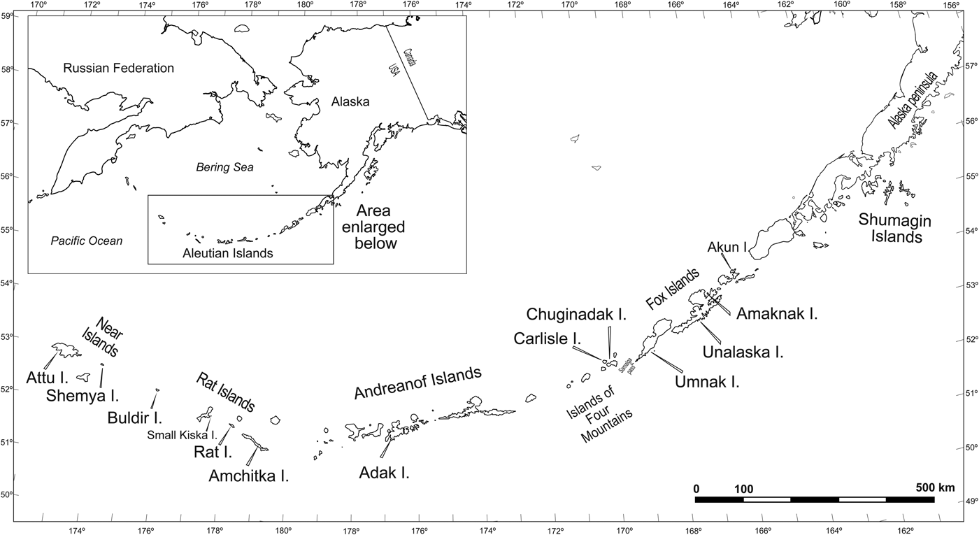
Figure 1. Map of the Aleutian Islands showing study area.

Figure 2. General locations of sites investigated in the Islands of Four Mountains.
Historical, ethnographic, and archaeological background
The Russian treatment of Unangax̂ that followed Vitus Bering's expedition for the Russian Empire and subsequent interactions with the promyshlenniki (Russian fur traders) was harsh, particularly during the AD 1761–1762 hunting/trapping season. The Aleut people of the Four Mountains, Umnak, Unalaska, and Akutan Islands banded together to defend themselves against Russian fur trappers and traders in what is now known as the “Aleut Revolt” (Laughlin, Reference Laughlin1980, p. 128). In retaliation, circa AD 1763–1764, the Russians returned and destroyed Unangax̂ villages in the Four Mountains, on Samalga, and on the south side of Umnak (Laughlin, Reference Laughlin1980, p. 128; Black, Reference Black1984, p. 86). In some accounts, this retaliation was done at the request of Umnak Aleuts (Veniaminov, Reference Veniaminov1984). Whatever the cause, in the IFM, the Russians killed nearly all of the men, while women and children either starved or were relocated to Umnak Island possibly as late as AD 1767 (Black, Reference Black1984, p. 44). By the AD 1770s, no Unangax̂ permanently inhabited the IFM (Veniaminov, Reference Veniaminov1984, p. 251), although fox trappers periodically used the islands until well into the twentieth century (Bailey, Reference Bailey1993).
Further historical accounts include that of James Cook and his crew who, while seeking the Northwest Passage during their third global voyage, visited the Aleutians in 1778, spending most of their time on Unalaska and mapping the IFM in passing (Hayes, Reference Hayes1999). By the time of Cook's third voyage, the Unangax̂ had not inhabited the IFM for almost a decade. In 1781, threatened by this English encroachment, Russian explorers produced a map of their Aleutian voyages, crudely depicting the IFM (Lovtsov et al., Reference Lovstov, Black and Pierce1991). Also in response to English intrusion, Russia launched the Billings Expedition between 1785 and 1795, which created new, more accurate maps of the Aleutian Islands that included the IFM (Jones, Reference Jones2014). During the 1830s, Father Veniaminov recorded the culture, geology, and natural history of the eastern Aleutians that documented the IFM (Veniaminov, Reference Veniaminov1984). From his work, we gain our richest knowledge of the IFM less than 70 years after indigenous people last inhabited these islands. In addition, stories passed down through the generations provide some insight into what life was like in the Four Mountains, which include a story about starvation (Galaktianoff, N., Sr., “Lucky Charms: A Story from the Islands of Four Mountains,” recorded by Golodoff, S., Sinnot, K., Alaska Humanities Oral History Project with the Unalaska School; Golodoff, S., personal communication 2018).
Early archaeological investigations in the IFM were poorly documented (Dall, Reference Dall1878; Jochelson, Reference Jochelson1925) or focused almost exclusively on the richly appointed human burial caves for which the islands are famous (Hrdlička, Reference Hrdlička1945; Bank et al., Reference Bank, Spaulding, Miller and Bank1950; Bank, Reference Bank1953, Reference Bank1956; Laughlin, Reference Laughlin1980). McCartney (Reference McCartney1972) conducted the first formal survey of the IFM, identifying 12 sites among the eight islands. Under the Alaska Native Claims Settlement Act (ANCSA), the U.S. Bureau of Indian Affairs (BIA) conducted mapping of surface features and surface collecting of 15 IFM village sites (Cooper, Reference Cooper1991; Fogarty, Reference Fogarty1991a, Reference Fogarty1991b; O'Leary, Reference O'Leary1993a, Reference O'Leary1993b, Reference O'Leary1993c; Turck, Reference Turck1993). These reconnaissance studies recovered a small amount of material and obtained a few radiocarbon dates (Hatfield and West, Reference Hatfield and West2013; Hatfield et al., Reference Hatfield, Bruner, West, Savinetsky, Krylovich, Khasanov and Vasyukov2016). The archaeological site locations were ultimately conveyed to the Aleut Corporation and remain their property today. The BIA reports reveal how little we know about the Four Mountains archaeological record. This limited surface snapshot of Four Mountains cultural history is incongruous with the more robust eastern and central Aleutian ecological, oceanographic, and geologic data (e.g., Byrd et al., Reference Byrd, Renner and Renner2005; Call and Loughlin, Reference Call and Loughlin2005; Hunt and Stabeno, Reference Hunt and Stabeno2005; Ladd et al., Reference Ladd, Hunt, Mordy, Salo and Stabeno2005; Mordy et al., Reference Mordy, Stabeno, Ladd, Zeeman, Wisegarver, Salo and Hunt2005; Nicolaysen et al., Reference Nicolaysen, Allen, Dehn, Moore and Weis2003, Reference Nicolaysen, Bridges and Swapp2005; Pekar et al., Reference Pekar, Nicolaysen, Bridges and Dehn2005; Meleney et al., Reference Meleney, Nicolaysen and Dehn2008; Tremayne and Brown, Reference Tremayne and Brown2017).
Ours is the first interdisciplinary research program in the IFM region to bring more modern, interdisciplinary research tools and methodologies previously employed on other North Pacific island groups (e.g., Fitzhugh, Reference Fitzhugh2003; Maschner et al., Reference Maschner, Betts, Cornell, Dunne, Finney, Huntly and Jordan2009; Corbett et al., Reference Corbett, West and Lefèvre2010; West et al., Reference West, Hatfield, Wilmerding, Lefevre and Gualtieri2012). By design, our investigation sought a deep temporal understanding of Four Mountains prehistory through documentation of the stratigraphic relationships between anthropologically related features and artifacts with natural deposits. Summarizing initial results of Hatfield et al. (Reference Hatfield, Bruner, West, Savinetsky, Krylovich, Khasanov and Vasyukov2016), the 2014 field season established radiocarbon evidence for four components at SAM 0016 located on southern Chuginadak: one date between 3275 and 3444 cal yr BP (see Supplementary Tables 1 and 2), one date between 792 and 912 cal yr BP, two dates between 550 and 680 cal yr BP, and one date between 293 and 421 cal yr BP (Supplementary Table 1). Isolated shovel tests at three other sites yielded a few dates contemporary to these components. Along the northeast part of Carlisle Island, SAM0017 dated between 3338 and 3545 cal yr BP. The shovel test profile and radiocarbon date from the newly discovered SAM0047, located on the northern side of Chuginadak, revealed a single occupation component dating between 791 and 914 cal yr BP. Finally, two dates were obtained from shovel tests on Herbert Island both indicating one occupation between 315 and 464 cal yr BP. Combining the 2014 results (Hatfield et al., Reference Hatfield, Bruner, West, Savinetsky, Krylovich, Khasanov and Vasyukov2016) and the new results presented by this study allows the first assessment of landscape level settlement to address questions of continuity and resilience during periods of abrupt environmental change during the last ~4000 years.
We use a human ecodynamics approach (Walker and Salt, Reference Walker and Salt2006; Crumley, Reference Crumley, Hornborg and Crumley2007; Kirch, Reference Kirch2007; Fitzhugh, et al., Reference Fitzhugh, Butler, Bovy and Etnier2018; Hutchinson et al., Reference Hutchinson, Butler, Campbell, Sterling, Etnier and Bovy2018), drawing on resilience theory and historical ecology, to interpret human occupations in the Four Mountains—their ability to respond to natural disasters and to long-term environmental changes, as well as to the ecological variability in their ecosystem (Kirch and Hunt, Reference Kirch and Hunt1997; Lawson et al., Reference Lawson, Church, McGovern, Arge, Woollet, Edwards and Gathorne-Hardy2005; Erlandson and Fitzpatrick, Reference Erlandson and Fitzpatrick2006; Moss et al., Reference Moss, Yang, Newsome, Speller, McKechnie, McMillan, Losey and Koch2006; Walker and Salt, Reference Walker and Salt2006; Crumley, Reference Crumley, Hornborg and Crumley2007; Fitzpatrick and Keegan, Reference Fitzpatrick and Keegan2007; McGovern et al., Reference McGovern, Vésteinsson, Friđriksson, Church, Lawson, Simpson and Einarsson2007; Rick et al., Reference Rick, Erlandson, Braje, Estes, Graham, Vellanoweth, Rick and Erlandson2008; Butler et al., Reference Butler, Bovy, Campbell and Etnier2018a, Reference Butler, Bovy, Campbell, Etnier and Sterling2018b; Hutchinson et al., Reference Hutchinson, Butler, Campbell, Sterling, Etnier and Bovy2018). Kirch (Reference Kirch2007) utilized environmental archaeology, geography, anthropology, and ecology to investigate the interwoven relations between humans and their environment in Hawaiian archipelago. Similarly, our goal is to understand the occupation on the Four Mountains within the context of the geologic events (volcanic eruptions and tsunamis), long-term ecosystem and climate fluctuations, and prehistoric subsistence strategies to look at how the IFM shaped resilience and vulnerability. Similar to the research by Barton et al. (Reference Barton, Shirar and Jordan2018) in the central Alaska Peninsula, in this article, we focus on the occupation history evidenced by the stratigraphic and radiocarbon evidence to understand human resilience or vulnerability through time in the IFM in the face of volcanic eruptions (Okuno et al., Reference Okuno, Izbekov, Nicolaysen, Sato, Nakamura, Savinetsky and Vasyukov2017), site formation processes (Persico et al., Reference Persico, Lanman, Loopesko, Bruner and Nicolaysen2018), climatic changes (research which is ongoing, but see Savinetsky et al. [Reference Savinetsky, Kisleva, Khassanov, Corbett, West and Lefèvre2010]), and tsunamis (see Griswold et al., Reference Griswold, MacInnes and Higman2018), among other environmental/human relationships.
METHODS
This research project used standard archaeological, ecological, and geologic procedures to collect cultural, biological, and geologic samples from prehistoric village sites on Carlisle, Chuginadak, and Herbert Islands to gain information about (1) shifts in faunal compositions across time and space, (2) changes in material culture over time, (3) the eighteenth-century Russian/Aleut conflict, and (4) impacts of, and reactions to, geologic processes including volcanic eruptions and major subduction zone earthquakes. A wide array of information resulting from these methods is not included herein (i.e., material culture change over time); however, for this article, we focused on the stratigraphic evidence of occupations in the Four Mountains. During 2014 and 2015, we shovel tested several sites (SAM0047, SAM0016, SAM0031, AMK0003, and AMK0008), excavated units at three sites (SAM014, SAM016, and AMK003), and extracted samples from vertical and horizontal exposures that included charcoal, artifacts, faunal remains, ecofacts, soil samples, and sediment cores from four sites (SAM0014, SAM0017, SAM031, and AMK003). One outcome of this reconnaissance is that our team recorded a new site (SAM0047) on Chuginadak Island. The amount of material recovered from each of the nine sites varied by the intensity of investigation.
To understand the role the IFM people played in the larger prehistoric Aleutian theater, we focused on two village sites: SAM0014 (Tana Aguna) on Chuginadak Island and AMK0003 (Ulyagan) on Carlisle Island. Excellent natural exposure of the stratigraphy in deep gullies and beach cliffs flanking sites allowed our team to investigate long habitation sequences without requiring excavation of large horizontal areas. This approach was both efficient, given limited field time, and sensitive to the impending loss of cultural material because of erosion. At sites on Chuginadak and Carlisle, we sampled natural stratigraphic layers to identify past volcanic and geomorphological events (see Persico et al., Reference Persico, Lanman, Loopesko, Bruner and Nicolaysen2018).
At both sites, we identified chipped and ground stone artifacts, bone tools, sedimentary layers, volcanic tephras, faunal remains, and charred plant remains. The W.M. Keck Carbon Cycle Accelerator Mass Spectrometry Laboratory, University of California, Irvine, dated materials from SAM0014, SAM0016, SAM0017, SAM0047, AMK0003, and AMK0008, as well as AMK0009 (Supplementary Table 1). Conventional 14C ages were calibrated to “calendar” years in the CALIB 7.1 program (http://calib.org/calib/) using calibration curves IntCal09 for terrestrial material and Marine13 for marine material (Stuiver et al., Reference Stuiver, Reimer and Reimer2017). Sediment from a profile at SAM0014 and at AMK0003 was characterized using grain-size and micromorphological analyses.
RESULTS
At Tana Aguna (SAM0014) and Ulyagan (AMK0003), we investigated the stratigraphy, material culture, occupation history, and volcanic eruptive histories. Both sites are large villages intermittently occupied over the last four millennia. Tana Aguna (SAM0014) is a village characterized by small to medium oval surface features similar to most Aleutian prehistoric villages. In contrast, Ulyagan (AMK0003) has fewer small to medium oval features and is instead characterized by L-shaped longhouses and umqan features (large A-shaped trenches) that are similar to those excavated by Veltre and McCartney (Reference Veltre, McCartney and Dumond2001) at Reese Bay, on Unalaska, 150 miles west of the IFM. Faunal evidence suggests year-round occupations of these sites (Krylovich et al., Reference Krylovich, Vasyukov, Khasanov, Hatfield, West and Savinetsky2019). We recovered chipped stone projectile points, bifacial knives, flake tools, burins, ulus, among other chipped stone, bone, and ivory tool fragments, debitage, and debris. Supplementary Tables 1 and 2 compile the radiocarbon dates obtained from six sites, including paired samples for determination of the marine reservoir effect (West et al., Reference West, Khasanov, Krylovich, Hatfield, Khasanov, Vasyukov and Savinetsky2019). Supplementary Tables 2 and 3 list the recovered materials by site, unit, and level.
Tanax̂ Agunax̂ (SAM0014)
This north Chuginadak village is situated roughly 30 m above sea level (m asl) on an alluvial fan at the base of Tana volcano 11 km east of Cleveland (known as Chuginadax in Unangan Tanuu) volcano. This site has 67 mapped cultural features (house and other depressions) within an 80 m diameter area (O'Leary, Reference O'Leary1993a). These are predominantly oval depressions. We recovered abundant faunal remains in addition to bone, ivory, chipped stone, and ground stone artifacts from two excavated units (1 × 2 m in size) and one profile exposure (Supplementary Table 3; also see Krylovich et al. [Reference Krylovich, Vasyukov, Khasanov, Hatfield, West and Savinetsky2019] for faunal discussion). Eighteen radiocarbon dates range between 300 and 3800 cal yr BP (Supplementary Tables 1 and 2). Five of these dates were from crowberry (Empetrum nigrum)—a local woody plant used as fuel for a fire at the time of occupation, thus directly dating human activity. Other radiocarbon-dated samples include three from terrestrial feeding goose (Branta hutchinsii) bones, found in midden layers, which similarly reflect time of occupation and do not require correction for the marine reservoir effect. We selected bones of Irish lord fish (Hemilepidotus sp.), which require correction for the marine reservoir effect given their marine feeding environment. Using these terrestrial and marine paired dates, a correction factor, 495 ± 20 yr, was developed to adjust for the marine reservoir effect in the Four Mountains region (West et al., Reference West, Khasanov, Krylovich, Hatfield, Khasanov, Vasyukov and Savinetsky2019). Another eight dates were obtained from unidentified species of wood (charcoal), handpicked from the stratigraphy, and useful for interpreting human occupation and environmental response choices. These samples, however, may include driftwood collected from beaches by the inhabitants and/or include “old wood” portions of trees (the inner rings of trees that stop exchanging carbon after they are laid down). Both such samples potentially are older than the occupation layer in which the wood was found and thus may not correlate with stratigraphic relationships determined using the native terrestrial crowberry, the terrestrial goose bones, and the corrected fish bones.
The stratigraphy at Tanax̂ Agunax̂ (SAM0014) is interpreted based on two unit excavations and one profile exposure. Unit 1 is a 0.5 × 1.5 m unit on the edge of house pit 1 and excavated to 105 cm below the surface (cmbs). Deposits included unsorted cultural fill (silty loam) above a midden (Fig. 3). The cultural fill is associated with a single calibrated date (307–459 cal yr BP) taken from 60 cmbs (Supplementary Table 1). This layer of unsorted cultural fill is redeposited from either roof fall or house construction. Midden deposits are below this layer, which Krylovich et al. (Reference Krylovich, Vasyukov, Khasanov, Hatfield, West and Savinetsky2019) group into two depositional components: (1) an upper midden with sea urchin (Echinus) and shellfish remains and (2) a lower midden with some invertebrate remains. The upper shell midden includes layers A and B (60–90 cmbs), and the lower midden includes layers C–E (90–105 cmbs). Ten dates from the midden deposits span 2150 to 2850 cal yr BP (Supplementary Table 1). Although the strata appeared distinct during excavations, radiocarbon dates suggest that layers B and E are inverted with layers A, C, and D; this date inversion suggests some type of past disturbance. No significant tephra or ash layers were observed in the stratigraphy of unit 1. Stratigraphic mixing is not unexpected given construction of semi-subterranean houses across thousands of years (Johnson and Wilmerding, Reference Johnson, Wilmerding and Dumond2001).

Figure 3. Tana Aguna (SAM0014), unit 1, south wall profile, drawn by O.A. Krylovich and modified from Krylovich et al. (Reference Krylovich, Vasyukov, Khasanov, Hatfield, West and Savinetsky2019). Strata are measured in centimeters (cm) and include the following: layer 1, sod; layer 2, sediment; layers A and B, midden with sea urchin; layers C, D, and E, cultural fill with faunal remains
Tana Aguna, unit 2, is a 1 × 1 m unit within house pit 17 and excavated to approximately 40 cm below surface. We identified two cultural features interpreted as floors; the upper component ranging from 490 to 530 cal yr BP, and the lower component ranging between 1715 and 1820 cal yr BP (Supplementary Table 1; Fig. 4). The upper deposits above Floor #1 are composed of very dark-brown silt loam with mixed igneous lithics and cultural material (Supplementary Table 4). The deposit between Floors #1 and #2 includes layers C and D. Layer C is a pocket of gritty silt loam with fragments of griddlestone associated with a hearth. Cultural material included a snub-nosed hafted scraper or knife, a graver, and other lithic artifacts (see Supplementary Table 3). Layer D consisted of silt loam sediment with igneous lithics and pockets of light-gray ash and cultural material that included a projectile point/knife fragment, a knife, and other artifacts (Supplementary Table 3). Like SAM0014, unit 1, we excavated this house feature prior to tephrachronologist Okuno's identification of the CR02 sequence and Okmok II ash layer in the IFM (Okuno et al., Reference Okuno, Izbekov, Nicolaysen, Sato, Nakamura, Savinetsky and Vasyukov2017). However, we collected samples of sediment in this unit to determine at a later date sources of ash and tephra as well as other sediment attributes.

Figure 4. Tana Aguna (SAM0014), unit 2, stratigraphic profile, drawn by K.M. Bruner. Strata are measured in centimeters below surface (cmbs) and include the following: root zone (A); cultural fill (B); cultural feature (Fea #1); gritty sand layer (C); cultural fill, level 5 (D); and cultural fill with Feature #2 (Fea #2), cultural feature (E).
The West Ravine (WR) profile (Figs. 5 and 6) is located on the western side of Tana Aguna in an erosional gully that contains a robust stream only after rainstorms. We cleaned two sections of this profile (Main and North) along the same wall but separated by slumped ground surface approximately 1.5 m wide. We collected a handful of artifacts and burned wood for radiocarbon dating. The grain-size analysis of 28 samples taken from the Main WR profile reveals a distinct ~50-cm-thick tephra in stratum 7 that consists of 90% sand-sized particles in the <1 mm aliquot (Fig. 7). We correlate this layer with the coarse lapilli tephra member of the CR02 tephra. The soil analysis aided in identifying natural sediment and tephra layers, as well as cultural layers. Cultural features identified in the profile include a pit house and floor features below intercalated ash/tephra and sediment layers in the Main Section (Fig. 5, strata 19–26). Using radiometric dating, we identified three cultural occupations in the ravine profile: (1) the youngest dated to 2159–2339 cal yr BP (stratum 20), (2) the lowermost for the Main Section dated to 2963–3141 cal yr BP (stratum 26), and (3) the lowermost in the North Section dated to 3694–3830 cal yr BP (sample taken from charcoal lens at 193 cm below datum (cmbd), at the base of stratum 17). We recognized a sequence of eight tephra and nine sediment layers (strata 2–18) in the Main Section, which included the CR02 sequence, in layer 7, identified by Okuno et al. (Reference Okuno, Izbekov, Nicolaysen, Sato, Nakamura, Savinetsky and Vasyukov2017). Okuno also tentatively identified the Okmok II eruption as stratum 18 Main Section and stratum 12 North Section. Cultural layers lie below the intercalated tephra and sediment layers in the Main Section from stratum 19 to stratum 26. Cultural deposits consist of fill (roof and/or house construction) and four discrete cultural features (strata 20–23) that tend to have finer grain size than the surrounding fill (Fig. 7). Alluvial strata (strata 27–29) show an increasingly greater proportion of sand with increasing depth and lay at the base of the cultural deposits. Stratum 15, a thick volcanic ash, corresponds to stratum 5 in the North Section (Fig. 6). Importantly, these correlations suggest that erosion has removed the younger layers exposed in the Main Section from the upper North Section that is located closer to the shoreline. The North Section contains a sequence of two tephra and three sediment layers (strata 2–6). Cultural deposits in the WR North Section profile include cultural fill (strata 7, 9, 11, and 13) and a black charcoal-rich floor or other cultural feature (stratum 10). Stratum 12 is a discontinuous ash or tephra (possibly Okmok II) corresponding with stratum 18 in the WR Main Section.

Figure 5. Tana Aguna (SAM0014) West Ravine Main stratigraphic profile, drawn by V.L. Hatfield. Strata are measured in centimeters (cm) and include the following: sod (1), sediment (2), tephra (3), sediment (4), tephra (5) , sediment (6), CR02 tephra (7), sediment (8), tephra (9), sediment (10), tephra (11), sediment (12), ash (13), sediment (14), tephra (15), sediment (16), sediment with charcoal (17), tephra (discontinuous light-gray ash, possibly Okmok II) (18), cultural deposits (19), cultural features (20–23), cultural fill (24–26), and alluvium (27–29).

Figure 6. Tana Aguna (SAM0014) West Ravine North stratigraphic profile, drawn by V.L. Hatfield. Strata are measured in centimeters (cm) and include the following: sod (1), sediment (2), tephra (3), sediment (4), CR02 tephra (5), cultural deposits with charcoal and griddlestone (6), cultural fill (7), cultural feature (8), cultural fill (9), cultural feature (10), cultural fill (11), tephra (discontinuous light-brownish-gray ash, correlating with the main profile stratum 18, possibly Okmok II eruption) (12), cultural fill (13), sediment or tephra (14), sediment (15), cultural fill (very mixed) (16–18), possible posthole or other cultural fill (19), alluvium (disturbed) (20), cultural layer (21), alluvium (disturbed) (22), cultural deposit in slump (23). cmbs, centimeters below surface.

Figure 7. (color online) Graph showing percent grain size of samples from Tana Aguna (SAM0014) West Ravine Main stratigraphic profile.
Tanax̂ Agunax̂ village radiocarbon dates, features, and artifacts are consistent with other Aleutian sites dating between 3800 and 500 years ago (Knecht and Davis, Reference Knecht, Davis and Dumond2001; Corbett et al., Reference Corbett, West and Lefèvre2010; Hatfield, Reference Hatfield2010; West et al., Reference West, Hatfield, Wilmerding, Lefevre and Gualtieri2012). The round semi-subterranean house features at this village lack the stone foundations seen in some eastern Aleutian houses dating between 4000 and 2500 years ago. The house/floor features are consistent with the features seen across the Aleutian chain; so too is the cultural material. Deposition between floor features in unit 2 and the tephra deposition exposed in the WR profile indicate volcanism affected the occupation at this site. Whether this ash deposition caused abandonment is difficult to determine especially given the overlapping dates between the WR profile and unit 1. The amount of ash deposition witnessed in the WR profile with a lack of cultural deposition, however, does suggest periods of abandonment, especially combined with the dates from the other sites, which indicate a significant gap in occupation, discussed subsequently.
Ulyagan (AMK0003)
Located on southeast Carlisle Island, the Ulyagan site sits on an alluvial fan, approximately 30 m asl. A deep erosional gully with an ephemeral stream bisects the village and houses and umqan features occur on both sides. Initial geomorphological analysis indicates that the stream flowed more consistently in the past (Persico et al., Reference Persico, Lanman, Loopesko, Bruner and Nicolaysen2018). We excavated five units and recovered metal artifacts, a glass bead, and many bone and stone artifacts (Supplementary Table 4). At Ulyagan, 32 radiocarbon dates range from 150 cal yr BP to 3800 cal yr BP. These dates include 14 on crowberry (Empetrum nigrum), 3 on terrestrial feeding geese (Branta hutchinsii), 6 on Irish lords (Hemilepidotus sp.), and 9 on unknown wood (Supplementary Table 1). Terrestrial and marine paired dates were obtained from Ulyagan (see Supplementary Table 1 and West et al. [Reference West, Khasanov, Krylovich, Hatfield, Khasanov, Vasyukov and Savinetsky2019] for provenience) to develop a correction factor, 495 ± 20 yr, to adjust the marine reservoir effect in the Four Mountains region.
Units 1 and 2 are associated with house pit 36; unit 1 is located in the interior of the house, and unit 2 is located on the eastern exterior adjacent to the gully. We excavated unit 1 to 20 cmbs and discontinued because of time limitations. Recovery included a metal knife fragment, an unidentified metal, some griddlestones, charcoal, and debitage (Supplementary Table 4). Given the sparse excavations, the stratigraphy of this unit is not described here. One radiocarbon date on a burned wood, apparently part of house construction and likely driftwood, ranges from 10 to 273 cal yr BP (Supplementary Table 1).
We excavated Ulyagan unit 2 as a 1 × 1 m unit to 105 cmbd and continued excavation as a 50 cm diameter shovel probe to 150 cmbd. The stratigraphy of the west wall shows a small portion of layers 1 and 2, the grass/duff zone mixed with pumiceous tephra (Fig. 8). Below this horizon is a thick midden deposit (Crockford, Reference Crockford2016; also see Krylovich et al., Reference Krylovich, Vasyukov, Khasanov, Hatfield, West and Savinetsky2019). This midden (called the layer 3 midden) was 60–75 cm thick and encompassed layer 3b, a thick redeposited tephra that, although very thick on the western edge (as seen in the profile), did not occur on the eastern half of the unit. We excavated the midden in arbitrary levels (levels 2–6). Cultural materials from layer 3 midden included a glass bead, chipped stone tools and debris, and bone tools and debris (Supplementary Table 3). Three radiocarbon dates (ranging from 0 to 287 BP) indicate the layer 3 midden formed during the historic period (Supplementary Table 1).

Figure 8. Ulyagan (AMK0003), unit 2, stratigraphic profile of the west wall, drawn by K.M. Bruner. Strata are measured in centimeters below datum (cmbd) and include the following: layer 3, midden, historic midden deposit; layer 3b, redeposited tephra; CR02 tephra; layer 4, cultural deposits; layer 5, cultural deposits; layer 6, tephra; layer 7, dark charcoal lens (cultural feature); layer 8, tephra; layer 9, dark charcoal lens (cultural feature); layer 10, ash; and layer 11, mottled ash.
Ulyagan unit 2 layers 4 and 5, separated from layer 3 midden by the CR02 sequence, are cultural layers composed of a fine loam. Layer 6 is another tephra layer. Layers 7 and 9 are dark, charcoal dense cultural deposits that may be a floor or other burned features; a golden brown tephra (layer 8) separates layers 7 and 9. A gray ash (layer 10) occurs below layer 9, and the bottommost deposit, layer 11, is a mottled ash. These lower levels produced little to no cultural material because of the limited excavated volume.
Unit 3 was located on the southern edge of the Ulyagan site and measured 0.50 × 0.25 m. Located along the erosional edge of the site, the stratigraphy is compressed, compared with other units, because the unit is not located within a pit house. We excavated unit 3 to 135 cm below ground surface into debris flow deposits that predate human occupation. The profile shows the CR02 tephra sequence in levels 14 and 15 with four cultural layers above the CR02 tephra and one or two cultural layers below (Fig. 9). Dates on unidentified wood (n = 4) and crowberry (n = 3) are grouped into four periods: 800–960 cal yr BP, 1700–1900 cal yr BP, 3077–3230 cal yr BP, and 3615–3815 cal yr BP (Supplementary Table 1).

Figure 9. Ulyagan (AMK0003), unit 3, stratigraphic profile of the north wall, drawn by O.A. Krylovich. Strata are measured in centimeters below datum (cmbd) include: sod/root zone (A); sediment (B); cultural fill, layer I (C); cultural fill, layer II (D); cultural fill, layer III (E); cultural fill, layer IV (F); CR02 sequence of ash and tephra layers in levels 14 and 15 (Ash and Tephra); cultural fill, layer V (G); and debris flow deposits (H). L1 through L23 are excavation levels and are 5 cm thick.
Ulyagan unit 4 is located west of unit 3 along the southern erosional edge of the Ulyagan village, situated along a natural exposure above the beach. We excavated this unit to 3.0 m below ground surface using different excavation unit sizes and screening methods: the upper 1.05 m excavation measured a 1.5 × 0.5 m unit and was water screened; the middle excavation, from 1.05 to 2.00 m below datum, measured 0.25 × 0.5 m and was wet screened; and the lower section, from 2.0 to 3.0 m below datum, measured 0.45 × 1.0 m and was an unscreened shovel test (Fig. 10). Fourteen radiocarbon dates (see Supplementary Table 1) on crowberry (n = 7), unknown wood (n = 2), and Irish lord fish (Hemilepidotus sp., n = 4) date prior to the CR02 tephra (levels 14 and 15) and document at least four occupations: (1) 1850–1900 cal yr BP (levels 10 and 13); (2) 2100–2350 cal yr BP (levels 14, 17, 19, and 20), (3) 2700–2900 cal yr BP (levels 15–16); and (4) 3640–3830 cal yr BP (levels 32–33). Several of the dates are inverted—levels 17, 19, and 20 dating earlier than levels 15 and 16. This is likely because of house construction, consistent with features noted in excavation (Fig. 10). The excavation of the house potentially occurred around 2100–2350 cal yr BP resulting in mixed deposits with older (2700–2900 cal yr BP) materials.

Figure 10. Ulyagan (AMK0003), unit 4, stratigraphic profile, north wall. The upper section (separated from lower section by dashed line) is postexcavation, drawn by O.A. Krylovich, and is set back 50 cm from the lower section, drawn by V.L. Hatfield. Strata are measured in centimeters below surface (cmbs) and include the following: above ground surface (A); sod/root zone (B); sediment with some cultural material (C–E); CR02 tephra (F–G); cultural fill (H); cultural layer, midden (I); cultural fill (J); cultural fill (J1); cultural fill (J2); floor feature: dark brown to black (F1); cultural feature, floor (F2); noncultural sediment (K); tephra (L); tephra (L1); noncultural sediment (M and M1); tephra (N); tephra, perhaps the same as Q (O); noncultural: fluvial sediment (P); tephra (Q); cultural fill above house floor F5 (R); cultural fill, above F3 feature (possible floor) (S); possible floor, cultural feature (F3); cultural fill-roof fall/fill above feature F4 (T); tephra (U); noncultural sediment (V–W); tephra (X–Y); noncultural sediment (Z); tephra (AA–BB); noncultural sediment (CC); tephra (DD); noncultural, possibly tephra (EE–FF); debris flow (GG); tephra (HH); debris flow (II–JJ); fine ash (KK); tephra (LL); debris flow (MM); tephra (NN); debris flow (OO); tephra or ash (PP); and debris flow (QQ).
Ulyagan unit 5, located on the eastern side of Ulyagan village, across the gully that bisects the site, was a 1.0 × 0.5 m unit excavated to approximately 1.15 m in depth. The cultural layers include an upper layer (30–75 cm) with sea urchin and vertebrate remains; a middle layer (75–85 cm) of dark brown loam with low concentrations of faunal remains; and a lower midden (85–115 cm) with abundant faunal remains (see Krylovich et al. [Reference Krylovich, Vasyukov, Khasanov, Hatfield, West and Savinetsky2019] for figure and additional descriptions). These deposits all occur above the CR02 tephra sequence. Six radiocarbon dates (four on crowberry wood and two on fish) indicate an occupation from 309 to 499 cal yr BP (see Supplementary Table 1).
DISCUSSION
The IFM are remote and isolated. Little to no research has been conducted at these archaeological sites; thus we are only in the beginning stages of understanding the occupation sequence of humans and the impact natural and cultural events had on their ability to thrive in this region. However, based on the ecological and geoarchaeological evidence we gathered from the IFM, the prehistoric residents of the village sites appear resilient through dynamic long-term and abrupt events, including volcanic eruptions. Based on the radiocarbon dates we obtained (Supplementary Table 1), the occupation of these islands range from the Russian contact era to 4000 cal yr BP. All of the investigated sites are large villages and were likely used contemporaneously, indicating a substantial population of IFM villages during the past 4000 years. Deglaciation timing and spatial patterning, sea level change, and sea ice extent undoubtedly influenced colonization of these islands (Persico, et al., Reference Persico, Lanman, Loopesko, Bruner and Nicolaysen2018). There is some indication that people colonized these islands around 7000 years ago (Kuzmicheva et al., Reference Kuzmicheva, Smyshlyaeva, Vasyukov, Khasanov, Krylovich, Okuno, West, Hatfield and Savinetsky2019), but we do not have stratigraphic or radiocarbon evidence of this event. Further research in the Four Mountains may yet result in an extended time depth for the human occupations in these islands.
Although Ulyagan (AMK0003) and Tana Aguna (SAM0014) villages provide the most information regarding occupation range, seasonality, geologic hazard response, and resource use, all of the sites taken together indicate an intensive occupation of the island group. Based on radiocarbon dates from all of the sites investigated, excluding dates on fish bones, there are two significant gaps in the occupation sequence: (1) between 2100 and 1950 cal yr BP and (2) between 1700 and 1000 cal yr BP (Fig. 11, Table 1; Supplementary Table 1). In the WR profile, the CR02 sequence appears to be one of many eruptions, sandwiched between two or three tephra/ash deposits above and three or four tephra/ash deposits below this sequence. Given the degree of volcanism witnessed in the WR profile, it is likely volcanic eruptions are the cause of these hiatuses. The Okmok II caldera-forming eruption at ca. 2000 cal yr BP may have caused some disruption in the IFM. It was a large eruption occurring 126 km (80 mi.) east of the Four Mountains that directly or indirectly affected villagers. Because the Okmok II ash layer evident in Tana Aguna and Ulyagan is quite thin, a direct ecological and human mortality impact is unlikely. Certainly, we found no unusual accumulation of unbroken artifacts or other sign of rapid abandonment associated with either the CR02 tephra sequence or Okmok II ash layer in any excavated profile. Nonetheless, the Okmok II eruption would have caused significant land and sound vibrations that may have caused people to abandon the Four Mountains. Between 1700 and 1000 cal yr BP, there may have been a long sequence of eruptions, of which the CR02 sequence was one, and the repeated eruptions likely caused a 700-yr hiatus.

Figure 11. (color online) Radiocarbon date ranges from youngest (bottom) to oldest (top). An occupation hiatus is apparent between 2100 and 1950 cal yr BP and between 1700 and 1000 cal yr BP. See Table 1 and Supplementary Table 1 for dates, materials dated, and provenience information. These dates were calibrated with CALIB 7.1 (Stuiver et al., Reference Stuiver, Reimer and Reimer2017).
Table 1. Radiocarbon dates from Islands of the Four Mountains associated with Figure 11. ST, shove test; WRM, West Ravine, Main Section; WRN, West Ravine, North Section. AMK009 was investigated by Lucille Johnson (Johnson Reference Johnson2018). For additional information on these dates, see Supplementary Tables 1 and 2. Fea X is Feature X; OBSE, OBSW, GSW < and IFSE are provenience designations.
Both hiatus periods (2100–1950 and 1700–1000 cal yr BP) are associated with an increase in values of nitrogen isotope (Kuzmicheva et al., Reference Kuzmicheva, Smyshlyaeva, Vasyukov, Khasanov, Krylovich, Okuno, West, Hatfield and Savinetsky2019). Kuzmicheva et al. (Reference Kuzmicheva, Smyshlyaeva, Vasyukov, Khasanov, Krylovich, Okuno, West, Hatfield and Savinetsky2019) note high values of heavy nitrogen isotopes prior to 6900 cal yr BP, associated with high bird populations, followed by a drop in nitrogen isotope levels associated with a decrease in number of birds, potentially indicating human predation during the initial human colonization of the Four Mountains. Following colonization, there are two notable increases in nitrogen isotope levels, one around 1900 cal yr BP and one at 1100 cal yr BP, suggesting humans were not in the area hunting birds during these times. Nitrogen isotope values increase after 1000 years ago, which Kuzmicheva et al. (Reference Kuzmicheva, Smyshlyaeva, Vasyukov, Khasanov, Krylovich, Okuno, West, Hatfield and Savinetsky2019) associated with the return of human occupants to the Four Mountains, and the very low values at 500 cal yr BP reflect an intense human predation on birds in the area. Sampling error or unseen social causes are other possible explanations of the hiatuses, and further research is needed to evaluate these time gaps. It is possible that some event resulted in the death of Four Mountains occupants, and the 700-yr gap, for instance, reflects the amount of time for other Aleutian villages to recolonize these islands. Many of the possible scenarios are invisible in the archaeological record.
Village locations, sizes, and resilience
Most of the IFM village sites, including Ulyagan and Tana Aguna, are situated on debris flow deposits, and we suppose the age of settlements at these sites is restricted by the development of sediment on habitable landforms (see Persico et al., Reference Persico, Lanman, Loopesko, Bruner and Nicolaysen2018). Surface features at most of the sites in the IFM are predominantly oval house pit and smaller pit features (McCartney, Reference McCartney1972; Wraley, Reference Wraley1990; Fogarty, Reference Fogarty1991a, Reference Fogarty1991b; Cooper, Reference Cooper1991; O'Leary, Reference O'Leary1993a, Reference O'Leary1993b, Reference O'Leary1993c; Turck, Reference Turck1993; Hatfield and West, Reference Hatfield and West2013; Hatfield et al., Reference Hatfield, Bruner, West, Savinetsky, Krylovich, Khasanov and Vasyukov2016). The larger are likely Unangax̂ houses, typically semi-subterranean—an adaptation to the frequent strong winds—that were used year-round. Two exceptions are AMK0003, which has longhouses and umqan features, and SAM0016, which has multiroom houses and umqan features (Cooper, Reference Cooper1991; O'Leary, Reference O'Leary1993b, Reference O'Leary1993c; Hatfield and West, Reference Hatfield and West2013; Hatfield et al., Reference Hatfield, Bruner, West, Savinetsky, Krylovich, Khasanov and Vasyukov2016). The longhouses at AMK0003 are associated with the Russian contact period, similar to the longhouses documented by Veltre and McCartney (Reference Veltre, McCartney and Dumond2001) at the Reese Bay site on Unalaska Island. Longhouse architecture construction and use appear to be a late manifestation, no more than 800 years old; however, only a few of these features have been dated (Corbett, Reference Corbett2003). Rectangular houses are documented at the Amaknak Bridge site and other eastern Aleutians sites between 3000 and 1000 cal yr BP (Knecht and Davis, Reference Knecht and Davis2008; Davis and Knecht, Reference Davis and Knecht2010; Rogers, Reference Rogers2011), and complex longhouses are documented ethnohistorically in the eastern Aleutians by Veniaminov and Captain Cook (Veniaminov, Reference Veniaminov1984, p. 262; McCartney and Veltre, Reference McCartney, Veltre, Frohlich, Harper and Gilberg2002, p. 251; Corbett, Reference Corbett2003; Rogers, Reference Rogers2011). Umqan features are similarly young in age, no more than 600 years old (Aigner and Veltre, Reference Aigner and Veltre1976; Aigner et al., Reference Aigner, Veltre, Fullem and Veltre1976; O'Leary and Bland, Reference O'Leary and Bland2013). At SAM0016, 18 of the 52 surface features are large communal multiroom houses and are assumed to be late in age as well (O'Leary, Reference O'Leary1993b, Reference O'Leary1993c; Hatfield et al., Reference Hatfield, Bruner, West, Savinetsky, Krylovich, Khasanov and Vasyukov2016).
The prehistoric human populations in the Four Mountains were resilient in their response to the restricted subsistence resources (Krylovich et al., Reference Krylovich, Vasyukov, Khasanov, Hatfield, West and Savinetsky2019; Vasyukov et al., Reference Vasyukov, Krylovich, West, Hatfield and Savinetsky2019) and periodic volcanic eruptions. They were not affected by tsunamis at all (Griswold, et al., Reference Griswold, MacInnes and Higman2018). The limitations in resources that resulted from occupying small islands with little to no reef development and no large bays may have limited the number of settlements noted in these islands. Historic/ethnographic stories about starvation suggest these were difficult islands for subsisting on local resources. Vasyukov et al. (Reference Vasyukov, Krylovich, West, Hatfield and Savinetsky2019) suggest they may have adapted to resource restrictions by adopting alternative strategies by transporting foxes and/or dogs as food resources for lean times. However, overall, findings by Krylovich et al. (Reference Krylovich, Vasyukov, Khasanov, Hatfield, West and Savinetsky2019) indicate IFM occupants utilized a diverse resource base.
Tsunamis, volcanoes, and resilience
No site reported herein showed clear evidence of inundation by paleotsunamis. Modeling of tsunamis (Griswold et al., Reference Griswold, MacInnes and Higman2018) indicates that even unusually large tsunamis were too small to reach the elevation of inhabited sites, including accounting for typical values of coseismic subsidence (Bourgeois, Reference Bourgeois2006). Bering Sea–side sites are protected from direct onslaught of subduction zone tsunamis, and the Pacific Ocean sites are high enough to avoid being inundated during realistic tsunami scenarios (Griswold et al., Reference Griswold, MacInnes and Higman2018). If a tsunami were large enough to inundate a site, internal stratigraphy should reveal layers characteristic of a tsunami—that of clean (nonsoily) deposits of sediment in similar composition to the beach or adjacent shallow offshore substrate (Morton et al., Reference Morton, Gelfenbaum and Jaffe2007). However, the cobble-boulder or bedrock beaches adjacent to most sites in the IFM are unlikely to allow for the creation of tsunami deposits in the first place (Bourgeois and MacInnes, Reference Bourgeois and MacInnes2010), thus making the conclusion from modeling untestable.
Volcanism is evident at both of the sites, and two tephra are dated—the CR02 tephra at 1050 cal yr BP (Okuno et al., Reference Okuno, Izbekov, Nicolaysen, Sato, Nakamura, Savinetsky and Vasyukov2017) and the Okmok II ash dated at 2030 cal yr BP (Begét, et al., Reference Begét, Larsen, Neal, Nye and Schaefer2005; Okuno et al., Reference Okuno, Izbekov, Nicolaysen, Sato, Nakamura, Savinetsky and Vasyukov2017). On Chuginadak, the CR02 tephra sequence was identified in the WR profile (Main, stratum 7 and North, stratum 5) at Tanax̂ Agunax̂ (SAM0014). Tephra and ash layers occur above and below this sequence. Below the CR02 sequence is the Okmok II ash, dated at 2030 cal yr BP (Begét, et al., Reference Begét, Larsen, Neal, Nye and Schaefer2005; Okuno, et al., Reference Okuno, Izbekov, Nicolaysen, Sato, Nakamura, Savinetsky and Vasyukov2017). The younger floor feature in unit 2, house pit 17 (circa 500 cal yr BP) at Tanax̂ Agunax̂ affirms that people reoccupied this village in spite of numerous volcanic tephras that covered earlier occupations, as revealed in the WR profiles. On Carlisle, the Ulyagan village similarly was occupied for roughly 4000 years and definitely returned after eruptions. The tephra from eruptions prior to known human occupations are noted in units 3 and 4. In the unit 4 profile wall, the prehistoric excavation of a house pit cut through intercalated ash and sediment/debris flow deposits. In unit 3, the cultural component appears to be deposited directly above the CR02 tephra.
CONCLUSIONS
The research conducted by an interdisciplinary and international group of researchers is the first comprehensive investigation of the prehistoric and historic human occupation in the IFM. This research contributes substantially to current understanding of prehistoric lifeways in the Aleutian archipelago. The archaeological record of the IFM reveals the sustainability and resilience of the Unangax̂ people to environmental change during the four millennia prior to the arrival of Russians into the Aleutian chain. Tsunamis, earthquakes, and volcanic eruptions are known to affect other archaeological sites (see VanderHoek and Myron, Reference VanderHoek and Myron2004; Losey, Reference Losey2005; Ludwin et al., Reference Ludwin, Dennis, Carver, McMillan, Losey, Clague, Jonientz-Trisler, Bowechop, Wray and James2005, Reference Ludwin, Smits, Carver, James, Jonientz-Trisler, McMillan and Losey2007; Barton et al., Reference Barton, Shirar and Jordan2018). We find no evidence that paleotsunamis affected either the Tana Aguna or the Ulyagan village in prehistory, and perhaps their location atop a cliff of unconsolidated sediment buffered villages from unusual waves. Interestingly, Griswold et al. (Reference Griswold, MacInnes and Higman2018) documented the wave height that inundated the IFM was substantially lower (9 m asl) on Bering Sea shorelines compared with Pacific shorelines (18 m asl). The excavated and tested sites in our study were located within the passes of the Four Mountains on high landforms, although it is unclear whether this choice of village location related more to protection from prevailing storm directions, infrequent tsunami events, or human incursions. Unfortunately, the few villages in this region do not facilitate a robust statistical analysis of the question of village site choice. Volcanism, however, did affect the IFM villagers. The two hiatuses in occupation noted previously may reflect sampling error or unseen social events, but most likely are associated with the volcanism of this very active area.
With the exception of the hiatuses, the occupation of the IFM appears to have been resilient, with villagers exploiting the diverse maritime and terrestrial resources available. Although restricted by their location on high bluffs with narrow beaches and high-energy maritime ecosystems, the IFM villagers utilized sophisticated technologies, exploited high-quality resources, and appear well-adapted to the region. The diverse resources represented in the middens reflect resources that were accessible year-round. It is possible the presence of fox and dog in the 500-yr-old midden from the Ulyagan village indicates some resource stress, as suggested by Vasyukov et al (Reference Vasyukov, Krylovich, West, Hatfield and Savinetsky2019), but the general diversity reflected does not support this.
Additional archaeological evidence from the IFM may eventually fill the gap between the early settlements of the eastern Fox Islands that began 9000 years ago (Knecht and Davis, Reference Knecht, Davis and Dumond2001) and those of the central Andreanof Islands that were occupied by 7000 years ago (West et al., Reference West, Hatfield, Wilmerding, Lefevre and Gualtieri2012); however, our research did not reveal the antiquity anticipated. Our data do support continuity from 4000 years ago until contact with a shift sometime after AD 1000 in population dynamics (West et al., Reference West, Khasanov, Krylovich, Hatfield, Khasanov, Vasyukov and Savinetsky2019) and technology. The analysis by Kuzmicheva et al. (Reference Kuzmicheva, Smyshlyaeva, Vasyukov, Khasanov, Krylovich, Okuno, West, Hatfield and Savinetsky2019) suggests the arrival of humans to the Four Mountains ca. 7000 cal yr BP. Additional research is needed to identify locations that correlate with the initial settlement of these islands as populations moved westward into the central and western Aleutians. Based on our findings, it is clear that the Four Mountains villagers were in contact with other Unangax̂ populations as well as with people farther east. Lamentably, the economic exploitation by Russians and European Americans combined with their greater technological resources resulted in loss of life and culture to which now only the ethnohistorical, historical, and archaeological records bear witness.
ACKNOWLEDGMENTS
Co-PIs Dixie L. West, Virginia L. Hatfield, Kirsten Nicolaysen, and Breanyn T. MacInnes were awarded funding by the National Science Foundation Office of Polar Programs (OPP #1301927, OPP #1301925, and OPP #1301929), with support from the Keck Geology Consortium (REU #1358987), Russian Grant RFBR Nos. 15-04-04721, 15-04-07696, and 18-04-00782 and the Russian Programs Origin and Evolution of the Biosphere, the U.S. Geological Survey, the Alaska Volcano Observatory, the U.S. Fish and Wildlife Service, the Alaska Maritime National Refuge, the Aleut Corporation, and the Museum of the Aleutians. In addition, we thank the crew of the R/V Maritime Maid: Captain George Rains, engineer Joe Schmidt, ABS and cook Mike Despars, and ABS Wesley Jones, as well as Maritime Helicopters pilot Dan Leary and helicopter mechanic Mike Cooper. Thanks also go to Christie Haupert and her team with CH2M Polar Services, USGS geologists with the Alaska Volcano Observatory that included John Power, Christina Neal, John Lyons, William E. Scott, Max Kaufman, Kristi Wallace, Michelle Coombs, and Matthew Heaney, who helped both in the field and in the lab. Zoya Johnson and Ingrid Martis with Museum of the Aleutians provided invaluable logistical support. Jeff Dickrell and his high-school students in the Unalaska School District cleaned and analyzed midden remains and conducted their own research related to this project in 2014. Thanks to Ray Hudson and Suzi Golodoff for their insight into Unangax̂n traditions and language. Finally, thanks to Melissa Good with the Sea Grant Advisory Program, Marine Advisory Program in Unalaska for providing samples of modern invertebrates. Any opinions, findings, and conclusions or recommendations expressed in this material are those of the author(s) and do not necessarily reflect the views of the National Science Foundation. Thanks also to the reviewers and to Ben Fitzhugh for their assistance with this paper.
SUPPLEMENTARY MATERIAL
The supplementary material for this article can be found at https://doi.org/10.1017/qua.2018.149.