INTRODUCTION
Calcareous dust in close association with Pleistocene deposits occurs in Argentina from southern Patagonia to the Mendoza Precordillera, either mixed with the matrix or as fine layers, pockets, and infillings of thermal contraction wedges. Corte (Reference Corte1968), Corte and Beltramone (Reference Corte and Beltramone1984), Galloway (Reference Galloway1985), and Grosso and Corte (Reference Grosso and Corte1989) described periglacial features and the calcium carbonate (CaCO3) associated with them but did not question its origin. Abraham de Vasquez and Garleff (Reference Abraham de Vazquez and Garleff1985), del Valle and Beltramone (Reference del Valle and Beltramone1987), Buschiazzo et al. (Reference Buschiazzo, Martínez and Peinemann1987), Bouza et al. (Reference Bouza, Simón, Aguilar, del Valle and Rostagno2007), Bockheim et al. (Reference Bockheim, Coronato, Rabassa, Ercolano and Ponce2009), and Ribolini et al. (Reference Ribolini, Bini, Consoloni, Isola, Pappalardo, Zanchetta, Fucks, Panzeri, Martini and Terrasi2014) considered these calcareous accumulations as soil horizons linked to warm interglacial periods. The relationship between the periglacial features in the host material and the occurrence of CaCO3 was never addressed.
New information about the origin of these calcareous materials results from detailed observation of many outcrops ascribed to the lower to upper Pleistocene in Patagonia, the western Pampa, and the Paramillo de Uspallata in the Mendoza Pre-Cordillera at elevations from near sea level up to 2800 m asl, and from the samples of both the host material and the calcareous silt collected there. Microscopic and sedimentologic observations were carried out on more than 100 samples, and geochemical analyses were made for 24 of them (Techer et al., Reference Techer, Clauer and Vogt2014). The strontium isotopic data and the distribution patterns of the rare-earth elements (REEs) clearly indicate a similar glaciogenic origin for the dust collected all over Argentina. Some of the most demonstrative exposures studied and the results of the laboratory analyses of samples collected there are detailed here.
As a preliminary statement, we note that leaching does not result in a loose micrite, and a loose calcareous material mixed with the fine matrix or in thin layers and pockets is not typical of pedogenic horizons. For instance, the CaCO3 at all sites examined is independent from the surface soil and appears at various depths between carbonate-free layers, which excludes deposition from local percolating solutions. Also, the dust is intimately associated with the cryogenic deformations as cryoturbations or thermal contraction wedges, which makes postsedimentary penetration and crystallisation difficult to justify in a material strongly compressed and having undergone cryosuction. A supplementary fact is that, whatever the depth of the calcareous layers, colonies of calcified saprophyte fungal hyphae and sporae forming felts occur within. This means that calcitisation took place while the fungus was alive or immediately after its death before decay, as shown by Klappa (Reference Klappa1979). While fungi are found in soils at various depths, they only sporulate in the uppermost millimetres, indicating a subaerial environment. Therefore, the calcareous dust in which they lived must have fallen at the ground surface. This evidence supports the hypothesis that this calcareous silt is not pedogenic, but related to a dust fall over the region. Two questions arise from these observations: Where did the dust come from? How and when was it deposited? Recollection, comparison, and discussion of all available arguments about the alternative pedogenic or glaciogenic nature of the calcareous dust spread over most Argentina therefore appear justified and timely.
FIELD OBSERVATIONS
Four sites from those already described in Vogt (Reference Vogt1992), Vogt and del Valle (Reference Vogt and del Valle1994), Vogt and Corte (Reference Vogt and Corte1996), Vogt and Larqué (Reference Vogt and Larqué1998), Vogt et al. (Reference Vogt, Vogt and Calmels2010), and Techer et al. (Reference Techer, Clauer and Vogt2014) were chosen: Pampa del Castillo and Puerto Madryn in eastern Patagonia, Carapacha Chica in the western Pampa, and Paramillo de Uspallata in the Mendoza Precordillera (Fig. 1). They show that, despite the differences in latitude, elevation, age, and geologic and geomorphic context, the calcareous dust and its deposition mode appear to be the same everywhere.

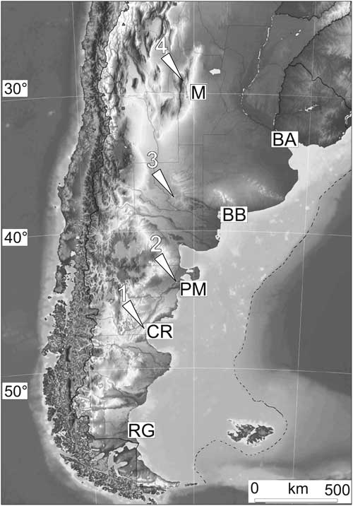
Figure 1 Map of Argentina with the location of Mendoza (M), Buenos Aires (BA), Bahia Blanca (BB), Puerto Madryn (PM), Comodoro Rivadavia (CR), and Rio Gallegos (RG). The white arrows and numbers indicate the sites studied: Pampa del Castillo (1), Puerto Madryn (2), Carapacha Chica (3), Paramillo de Uspallata (4). The dotted line delimits the emerged continental shelf during the glaciations.
Eastern Patagonia
This nearly 300-km-wide coastal belt forms a landscape of terraced Pleistocene gravel that incises a basement of Tertiary continental and marine sediments. At least five terraces descend gently in steps oriented southwest to northeast from 750 to 590 m asl at the Pampa del Castillo to 125 to 90 m at Puerto Madryn (42°45′S) 400 km away. All are covered by a 10- to 105-m-thick alluvial mantle called “Rodados patagónicos,” “Tehuelche,” or “Patagonian shingle” (Windhausen, Reference Windhausen1924; Sylwan, Reference Sylwan2001; Martínez and Kutschker, Reference Martínez and Kutschker2011) consisting of well-worn gravel of acid volcanic pebbles. Decimetre-sized cobbles with typical glacial parallel-piped shapes are visible in the well-layered and channeled, seldom cross-bedded, deposits with no fine-grained lenses and settling channels, the fine matrix being entrapped in the gravel. The sedimentary features suggest strong and regular flows, like those of a glacial discharge, carrying a voluminous load of coarse material over long distances (Urien et al., Reference Urien, Silva Martins and da Rosa Martins1993; Ponce et al., Reference Ponce, Rabassa, Coronato and Borromei2011). The alluvial gravel is capped until about 400 km inland by calcretes 20 to 60 cm thick. They consist of calcite with the same mineralogical and geochemical characteristics as those of the underlying calcareous dust. They are soft, except for their hard upper portion (20–25 cm), and appear centimetrically bedded, each layer showing its own network of desiccation cracks, thus intraformational. Decimetric cryoturbation folds involving several layers at once are visible, which evidently formed when the material was still plastic. The general features suggest an active layer above permafrost (Vogt and del Valle, Reference Vogt and del Valle1994).
Pampa del Castillo
The entire surface of the Pampa del Castillo has been extensively disrupted in the last decades by oil exploration and extraction, so that the exposure here described has been destroyed. Therefore, we rely in this presentation on observations we made before the oil companies moved in. A gravel pit revealed at least 3 m of “Rodados” undisturbed at the bottom, but affected in the upper 2 m by thermal contraction wedges filled with gravel and fine matrix mixed with 30% to 60% loose calcite and silica concretions. The gravel appeared strongly compressed between the wedges, and some cobbles were coated by opal. The deposit was capped by a 30- to 50-cm-thick calcrete consisting of 40% to 80% CaCO3. Del Valle and Beltramone (Reference del Valle and Beltramone1987) described three profiles in this area but did not mention the wedges. (Figs 1, site 1, and 2)
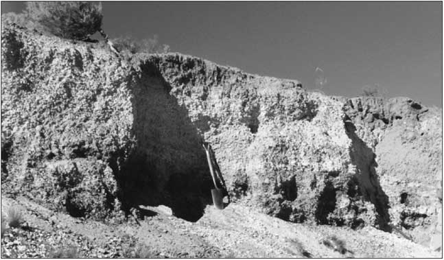
Figure 2 An exposure in the Pampa del Castillo terrace (45°07′S, 68°04′W), but no longer exists due to human modification. The calcareous dust is mixed with the gravels. A series of contraction wedges are visible. The spade indicates the scale.
Puerto Madryn
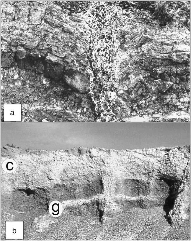
The lowest alluvial level of Puerto Madryn slopes by 0.16 %, heading to a base level of −150 m that corresponds to the lowest sea stand during the last glacial maximum (LGM). The bedrock consists of Miocene sandstone. A loose sandy layer is spread across the whole terrace. An outcrop by the roadside exposes a 2-m-deep and 0.5- to 0.6-m-wide thermal contraction wedge (Corte and Beltramone, Reference Corte and Beltramone1984). Filled with vertically arranged pebbles, sand and calcareous dust, it disrupts the bedrock (Figs. 1, site 2, and 3a).

Figure 3 Two exposures in the Puerto Madryn level (42°44.750′S, 65°15.950′W). (a) A 2-m-deep thermal contraction wedge breaks up and folds the Miocene sandstone (studied by Corte and Beltramone [Reference Corte and Beltramone1984]). It is filled with alluvial gravel from above and calcareous dust. (b) View of a >3-m-high gravel pit that exposes a series of thermal contraction wedges that disturb the alluvial deposit. Near the bottom, a gypsum crust (“g”) is related to a postglacial water table; “c” is the calcrete.
Nearby, a gravel pit studied by del Valle and Beltramone (Reference del Valle and Beltramone1987), Vogt (Reference Vogt1992), Vogt and del Valle (Reference Vogt and del Valle1994), and Vogt and Larqué (Reference Vogt and Larqué1998) shows “Rodados” more than 3 m thick. The deposit is clearly stratified and contains thin white lenses of clay and silica concretions. Cryogenic folds and compression figures disturb the layering. Several generations of thermal contraction wedges, 2−3 m apart and each buried by gravel beds, occur, all filled with gravel, sand, silica concretions, and calcareous dust that is strictly associated with the cryogenic deformations, whereas it is absent in the undisturbed layers at the bottom of the section. The CaCO3 content increases downwards from 28% to 48% in the wedges, associated with the <2 µm clay-size fraction that increases from 18% to 40%, which is typical of permafrost conditions (Corte, Reference Corte1962, Reference Corte1963). A continuous calcareous duricrust with 57% to 73% CaCO3 tops the sequence (Figs. 1, site 2, and 3b).
Carapacha Chica exposure in the western Pampa
The western part of the Pampa extends between 40°S and 35°S and from 63°W to 65°W in the eastern foreland of the Andes chain. It represents the southernmost extension of the Brazilian craton and is composed of metamorphic and intrusive rocks (granites, diorites) together with Paleozoic and Permo-Triassic sediments. Following the uplift of the Andes chain, this region was shaped in a pediment that is gently inclined eastwards. During the late Miocene, from 11 to 5.3 Ma BP, the pediment was blanketed by siltites, a sandy silt slightly cemented by silica, free of carbonate, with a loess-like structure and containing globular or elongated siliceous concretions. Pleistocene basalts flowed across the upstream portion of the pediment; hence it is called the Basaltic Meseta. Terraced sandy alluvium capped by siliceous duricrusts covers the whole plateau (Vogt et al., Reference Vogt, Vogt and Calmels2010). Calcareous dust is present in the fluvial deposits and over the basalt flows.
The Sierra Carapacha Chica is a basement outcrop of hard Permian arkosic sandstones located at the southwestern margin of the plateau (37°31.683′S, 66°24.550′W). At the bottom of the north-facing slope, a 3- to 3.5-m-high outcrop exposes a gelifluction accumulation of shattered rock. The basal portion is free of CaCO3 and is overlain by layers slightly indurated by a fine matrix containing 20% to 25% CaCO3 between carbonate-free layers. A siliceous duricrust tops the sequence (Figs. 1, site 3, and 4).
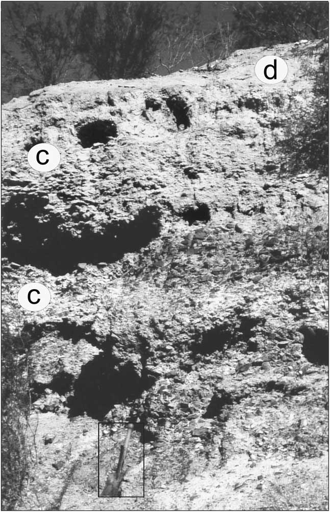
Figure 4 The Carapacha Chica exposure (37°31.683′S, 66°24.550′W). The gelifluction deposit consists of shattered siliceous sandstone mixed with scarce matrix. The clasts are angular and heterometric. The white material (“c”) is CaCO3. The deposit is capped by a duricrust (“d”). The hollows are bird nests in the soft calcareous accumulation below the duricrust. The spade at the bottom gives the scale.
Paramillo de Uspallata
The Paramillo de Uspallata (32°00′S, 69°00′W) is a high plateau between 3200 and 2700 m asl in the Mendoza Precordillera that possibly represents the eastern portion of the early Miocene planation surface uplifted to 6000 m in the Frontal Cordillera (Ramos and Cortes, Reference Ramos and Cortes1993). The bedrock consists of upper Keuper sediments, mostly schists interbedded with rhyolites and sandstones, and upstanding dacite dykes. No evidence of glaciers older than the middle Pleistocene has been reported on the eastern side of the Andes further north of Patagonia. Between 33°S and 36°S, where the chain is the highest, the oldest glaciation (“Uspallata glaciation”) is ascribed to the early middle Pleistocene (Espizua and Bigazzi, Reference Espizua and Bigazzi1998; Espizua, Reference Espizua2004), which means that no glacier existed at the Paramillo de Uspallata during the early Pleistocene.
Periglacial processes reshaped the surface during the Pleistocene glaciations to a cryopediment 3 by 12 km wide covered by a thick gelifluction deposit spread on a smooth surface and incised by sporadic gullies. The upper portion of the deposit is visible over several hundred metres in banks about 2 m high on the road from Villavicencio to Uspallata (“ruta de los Caracoles”). Beside some poorly sorted boulders up to 50 cm in length, dacite clasts 1–20 cm across are mixed with a matrix of finely disaggregated dacitic brown-ochre sand. Devoid of CaCO3, the bottom is overlain by the same materials, made whitish by the presence of calcareous dust. A layer of small cryoclasts in an ochre-coloured, carbonate-free sandy matrix mixed with reddish clay forms an intermediate layer. Coarse gravel and boulders with a carbonate-rich matrix in an upper layer suggest some runoff. Fine gravel in a greyish-brown matrix and a sandy, silty, and humic surface soil cap the sequence. The whole profile displays cryoturbation features such as folds and extrusions and particle sorting with the finest fraction increasing downwards. The CaCO3 content can be as much as 55%, and calcitic pendants at the lower face of gravels showing congelation features are frequent (Vogt and Corte, Reference Vogt and Corte1996). The cryopediment contains the largest amounts of calcareous dust, but calcareous silt and calcitic pendants also occur in a nearby rock glacier by the road at 1800–1100 m asl, and the same kind of gravels are sparse all along the slope following the deep incision that leads to the valley bottom several hundred metres further down (Figs. 1, site 4, and 5).
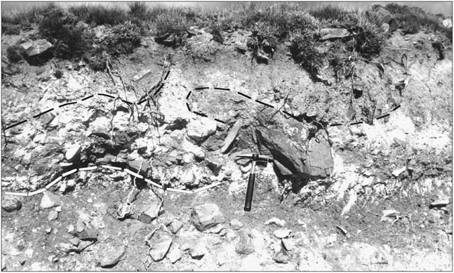
Figure 5 An exposure by the Ruta de los Caracoles, at the Paramillo de Uspallata: two carbonate-rich layers in the gelifluction deposit affected by folds, underlined by the black and the white dashes. The hammer in the middle gives the scale.
CALCAREOUS DUST
Wherever collected, the calcareous dust consists of a loose material that crumbles easily even when consolidated. Its proportion in the host sediment is variable but never less than 10% by volume and can amount to 70% in some pockets. It consists of fine-grained calcite (2 to 5 µm, micrite).
Microscopic characteristics
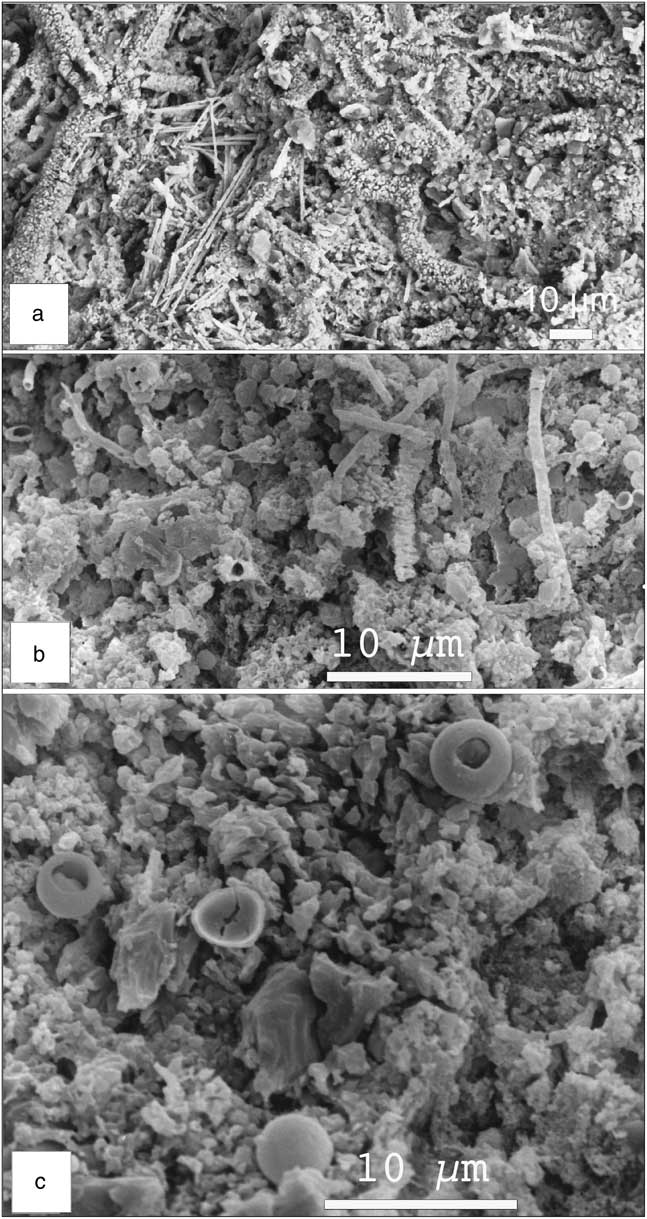
Owing to the size of its particles, this fine material is best observed by scanning electron microscopy (SEM). The calcite appears as very well preserved, loose rhombohedral and scalenohedral idiomorphic crystals. Traces of dissolution only appear in the vicinity of fungal colonies. Recrystallisations with typical congelation features (Vogt, Reference Vogt1990; Vogt and Corte, Reference Vogt and Corte1996) occur in the gelifluction deposits. Round frosted and nail-scratched quartz grains typical of wind activity are mixed with the dust. Grains of sodium chloride and gypsum, clearly of allochtonous origin relative to the local bedrock, are also present. Littoral glossy ovoid quartz grains and ooids occur in the samples from eastern Patagonia. The quantity and homogeneity of the material all over Argentina is remarkable, whatever the nature of the bedrock, host sediment, and surrounding slopes (Figs. 6–9).

Figure 6 Scanning electron microscopy photographs showing the calcite within the calcareous dust: Calcite crystals with scalenohedral shape from (a) the Paramillo de Uspallata and (b) the Carapacha Chica exposure, with incipient cryogenic crystallization in the centre. The shape of the calcite is the same in all studied sites.
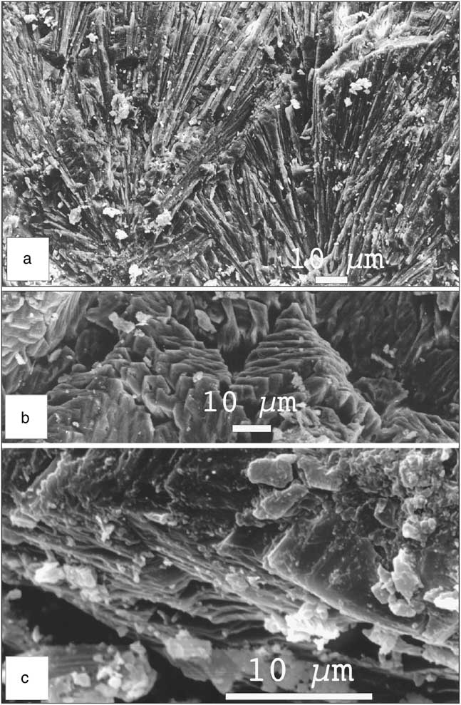
Figure 7 Cryogenic lamellar crystals: (a) dendritic assemblage of needles growing from calcitic dust; (b) the lamellar crystals assemble together to form needles; (c) detail of the lamellar crystals.

Figure 8 Scanning electron microscopy photographs showing the colonization of the calcareous dust by fungi: (a) and (b) calcitized fungal hyphae; (c) a cluster of calcitized sporae.

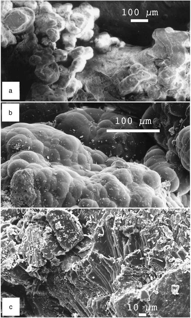
Figure 9 Scanning electron microscopy photographs showing (a) a cluster of ooids cemented by calcite; (b) neoformed opal; (c) gypsum platelets, a cryogenic structure also observed in Antarctica (Vogt and Corte, Reference Vogt and Corte1996).
Origin of the calcite
Limestone outcrops occur all along the Andean chain, and the waters of rivers and lakes contain some CaCO3 but massive precipitation of calcite is currently not observed, and if it occurs it is never powdery. The solubility of CaCO3 increases when the temperature decreases, and therefore the colder the water, the higher the concentration of CO2; close to 0°C the content of CaCO3 can reach 299 mg/L (Ek and Pissart, Reference Ek and Pissart1965). Calcium concentration in glacial water is also high relative to other cations (Anderson et al., Reference Anderson, Drever and Humphrey1997). Calcite represents up to 20% of the glacial rock flour, even if the parent rocks contain very little CaCO3 (Bukowska-Jania, Reference Bukowska-Jania2007). When glacial rivers once discharged from subglacial environments meet subzero air temperatures, calcite precipitates by freezing as loose micrite with crystalline rhombohedral or scalenohedral shapes (Fairchild et al., Reference Fairchild, Killawee, Spiro and Tison1996; Clark and Lauriol, Reference Clark and Lauriol1992; Zák et al., 2004). A glacial origin in a cold environment may therefore be assumed for this powdery calcite.
To verify this hypothesis, strontium, carbon, and oxygen isotopic analyses, as well as REE distribution patterns were determined on 24 samples collected from Rio Gallegos (51°30′S) to Paramillo de Uspallata (≈32°S). The ∂13C values obtained range from −1.9 to −7.2‰ (VPDB) and match with previously published values of Argentinean calcareous dust (Mercer, Reference Mercer1983; del Valle and Beltramone, Reference del Valle and Beltramone1987; Zech et al., Reference Zech, Zech, Kull, Kubik and Veit2011), which confirms a continental, but not necessarily a pedogenic origin. Del Valle and Beltramone (Reference del Valle and Beltramone1987), for instance, reported ∂13C between −3.7‰ and −8.7‰, clearly outside those of pedogenic carbonates, which usually range between −8‰ and −12‰ (e.g., Salomons and Mook, Reference Salomons and Mook1976). Margaritz et al. (1981) also published ∂13C values of pedogenic calcite of paleosols from about 22 to 1.7 ka BP in Israel, showing that except for the ∂13C of the oldest calcite at −2.6‰ (±1.9), the other 11 published values range from −7.7‰ (±0.4) to −11.7‰ (±1.3), which is, again, clearly outside the range reported by Techer et al. (Reference Techer, Clauer and Vogt2014). Later, Cerling and Quade (Reference Cerling and Quade1993) showed that the ∂13C of pedogenic calcite correlates with the contents of C3 and C4 in each soil ecosystem. In fact, the ∂13C values from a compilation of C3 and C4 plants ranged from about −20‰ to −33‰ for the former and from about −9‰ to −17‰ for the latter, significantly off the values from −1.9‰ to −7.2‰ obtained for the calcareous dust studied here. In turn, the carbon isotopic composition of pedogenic carbonates does not simply result from that of the minerals from which they precipitated (Salomons and Mook, Reference Salomons and Mook1976), as crystallisation temperature and isotopic composition of the interacting solution also impact the carbonate ∂13C. This latter relationship between pore water moving through a soil and crystallising calcite was confirmed by the identical 87Sr/86Sr ratios for both (Thellier and Clauer, Reference Thellier and Clauer1989). In fact, each pedogenic calcite yields the specific isotopic signature of soil solutions that integrate all soluble elements before precipitating the authigenic calcite. This can in no way be the case for the calcareous dust studied here, as most Argentine deposits hosting carbonate dust do not reflect homogeneous conditions. Also, there is a clear gap between the ∂13C data obtained for the calcareous dust and the values that characterize pedogenic calcite.
An alternative interpretation has to be provided, which has never been done in all earlier publications referred to previously. For instance, C3 and C4 plants almost contemporaneous with the LGM, such as those found in Australia, did not necessarily release ∂13C that was taken up by soil carbonate resulting in a pedogenic signature (Quade et al., Reference Quade, Chivas and McCulloch1995). In fact, it has not yet been proved that such C3 and C4 plants were contemporaneous with the calcite dust of Argentina. Furthermore, no solid argument has been given until now about the transfer of invariable ∂13C from plants to authigenic calcite. In summary, there is no reason to doubt that the ∂13C values from −1.9‰ to −7.2‰ (VPDB) refer to a glacial origin for the carbonates analyzed (Techer et al., Reference Techer, Clauer and Vogt2014), unless sustainable contradictory arguments that are still missing are provided.
The narrow range of the 87Sr/86Sr ratio from 0.706463±0.000008 to 0.707477±0.000006 (2σ) reported for the carbonate dust (Techer et al., Reference Techer, Clauer and Vogt2014) represents another essential argument against a pedogenic origin. Indeed, it has been known for a long time that there is no way to correlate a constant 87Sr/86Sr ratio with a pedogenic process. The deposits described earlier are derived from varied bedrock sources, from basic volcanic rocks and acidic plutons to marine sediments of ages from the Paleozoic to the Triassic, that have a wide spectrum of mineral composition over the area of interest. The constitutive minerals of such sediments are variably affected by weathering, and they release strontium with variable 87Sr/86Sr ratios that definitely cannot fit within the homogeneous overall 87Sr/86Sr ratio obtained for the observed calcite. Of all the arguments against a glaciogenic origin of the calcareous dust, this is probably the most difficult one to deny, ignore, or discard. Ultimately, no valid argument could explain homogeneous 87Sr/86Sr generated from sediments derived from such varied bedrock over such a wide area as is considered here.
Last but not least, the REEs of the carbonate dust yield constant patterns with, importantly, a specific negative cerium anomaly (Techer et al., Reference Techer, Clauer and Vogt2014). Again, the homogeneity of a geochemical signal for the carbonate dust all across Argentina, together with its negative cerium anomaly, is a supplementary determining argument. Indeed, continental calcite from any kind of soil does not yield the negative cerium anomaly that is rather representative of minerals crystallising in contact with seawater. In turn, both the 87Sr/86Sr ratio and the negative cerium anomaly require crystallisation in a large, homogeneous reservoir with seawater supply during periodically similar episodes and not in continental soils affected by pedogenic weathering that are necessarily heterogeneous.
There should always be more data than those available to consolidate a demonstration, but here the combination of the 14C ages that will be discussed later, the combined ∂13C values, the 87Sr/86Sr ratios, and the REE distribution patterns point consistently to the same origin for the calcareous dust.
Age of the calcareous dust
The calcareous dust was observed in all deposits ascribed to the Pleistocene by geologic and geomorphological evidences. Paramillo de Uspallata is the oldest Pleistocene formation in the Mendoza Precordillera, according to Harrington (Reference Harrington1941). As it is at a higher elevation than the middle and late Pleistocene features at about 2000–1500 m asl, and as the bottom of the nearest valley is at about 2000 m asl, this formation could be of lower Pleistocene age. Sylwan (Reference Sylwan2001) ascribed the alluvial cover of the Pampa del Castillo, the oldest and highest terrace in littoral Patagonia, to the Great Patagonian glaciation (GPG; 1.17 to 1.02 Ma). The alluvium covering the plateau and its surroundings in the western Pampa contains basalt debris and is therefore of Pleistocene age. Geomorphological considerations place it between the lower and the middle Pleistocene (Vogt et al., Reference Vogt, Vogt and Calmels2010).
Using 14C dating, Corte and Beltramone (Reference Corte and Beltramone1984) estimated the age of the CaCO3 collected at about 1 m below the surface in the Puerto Madryn level to be 27.2±0.3 ka BP in the outer parts of the wedge and 22.7±0.5 ka BP in the central part. These ages correspond to the LGM. Additional 14C ages reported by del Valle and Beltramone (Reference del Valle and Beltramone1987) in the nearby exposure are within the same time range: 36.5±2.5 ka BP at about 2 m below the surface and 24.3±0.95 ka BP at about 1 m below the surface. These ages agree with the estimates of Mercer (Reference Mercer1983) and Zech et al. (Reference Zech, Zech, Kull, Kubik and Veit2011). Farther southwest in Patagonia, Bockheim and Douglass (2006) obtained 239U–230Th ages of 224, 209, and 24 ka for carbonate rinds that they did not describe, which correspond to glacial periods.
Corte (Reference Corte1968) described succinctly an exposure about 12 km to the south of Rio Gallegos (≈51°30′S), along the road to Punta Arenas at 20 m asl. Gravel appears well layered at the bottom, whereas it is strongly disturbed between 120 and 60 cm below the surface by thermal contraction wedges filled with sand, 50 to 60 cm deep and about 1.5 m apart. The gravel between the wedges is strongly compressed, forming involutions. A line of ventifacts, perhaps a lag pavement, occurs between the contraction wedges and the sandy surface layer. Whereas the gravel at the bottom and the sand in the wedges are devoid of CaCO3, two layers containing calcareous dust are visible in the cryoturbated gravel between the wedges. Corte provided us with two samples from those two layers for chemical analyses. CaCO3 content amounts to 20%, the calcite is the same loose micrite as described elsewhere, and many round aeolian-shaped grains are present in the coarse (>600 μm) sand fraction. The wedges and sand infilling are evidently younger than the underlying gravel and calcareous dust, but no 14C ages are available. Despite a closer proximity to Antarctica, the periglacial features are far less conspicuous than those in Puerto Madryn. A cold episode (Antarctic cold reversal) occurred between 14.8 and 12.6 ka BP at 50°S (Moreno et al., Reference Moreno, Kaplan, François, Villa-Martínez, Moy, Stern and Kubik2009; Murray et al., Reference Murray, Carlson, Singer, Anslow, He, Caffee, Marcott, Liu and Otto-Bliesner2012), with freezing temperatures all year round to the south of this latitude (Marsh and Ditlevsen, Reference Marsh and Ditlevsen1997). Heusser (Reference Heusser1989) and Rabassa et al. (Reference Rabassa, Coronato and Salemme2005) also dated a last glacial occurrence at about 11 ka BP in the Beagle Channel near Ushuaia. The sand wedges and fillings at Rio Gallegos could then belong to this late cold episode.
Once more, it appears that the dust originated under glacial conditions. The next question is: Does it correspond to the climatic and edaphic environment of the glacial times in Argentina?
CENTRAL AND SOUTHERN ARGENTINA DURING THE GLACIAL EPISODES
The Andes Mountain chain and Antarctica are the two major features controlling the climate of southern and central Argentina. When the upper Miocene (≈11 to 5.3 Ma) glaciations of Antarctica caused an expansion of the ice sheet with a resulting global fall of the sea level (Flower and Kennett, Reference Flower and Kennett1994), the climate of southern Argentina became colder and drier. A major glaciation affected southern South America at some time between 7 and 4.6 Ma (Mercer and Sutter, Reference Mercer and Sutter1982). Clapperton (Reference Clapperton1993b) and Rabassa et al. (Reference Rabassa, Coronato and Salemme2005) reported at least eight glacial episodes during the middle and upper Pliocene, and the GPG between 1.17 and 1.02 Ma was followed by 14 to 16 cold events until the LGM, which occurred from about 26.5 to 19 ka BP. The LGM began earlier in the southern Andes, about 39 ka according to Zech et al. (Reference Zech, Zech, Kull, Kubik and Veit2011), which is consistent with the earlier estimation of Mercer and Laugénie (Reference Mercer and Laugénie1973).
The Antarctic ice growth covered the southern portion of the Atlantic Ocean and resulted in a 100–50 m drop in sea level below the present-day level. During the LGM, the Antarctic grounded ice reached the shelf edge (Anderson et al., Reference Anderson, Shipp, Lowe, Wellner and Mosola2002; Graham et al., Reference Graham, Larter, Gohl, Dowdeswell, Hillenbrand, Smith, Evans, Kuhn and Deen2010; Ingólfsson, Reference Ingólfsson2004; Cofaigh et al., Reference Cofaigh, Davies, Livingstone, Smith, Johnson, Hocking and Hogdson2014), while the Antarctic sea ice expanded to 60–48°S (present position 70–60°S), doubling its surface area and reducing the surface area of the southern Atlantic Ocean (Crosta et al., Reference Crosta, Pichon and Burckle1998; Crosta, Reference Crosta2009; Guilderson et al., Reference Guilderson, Burckle, Hemming and Peltier2000; Violante et al., Reference Violante, Paterlini, Marcolini, Costa, Cavallotto, Laprida and Dragani2014). Currently at 50–53°S, the Austral polar front shifted about 5–6° northwards (Paskoff, Reference Paskoff1967; Caviedes and Paskoff, Reference Caviedes and Paskoff1975; Clapperton, Reference Clapperton1994), towards 51°S (Garcia et al., Reference Garcia, Kaplan, Hall, Schaefer, Vega, Schwartz and Finkel2012), even to 45°S (MARGO, 2009), with a correlated 4–6°C cooling of the ocean surface (Gersonde et al., Reference Gersonde, Crosta, Abelmann and Armand2005; Kaiser et al., Reference Kaiser, Lamy and Hebbeln2005) and a 5–8°C drop near Argentina (Hulton et al., Reference Hulton, Purves, McCulloch, Sugden and Bentley2002; Kull et al., Reference Kull, Hänni, Grosjean and Veit2003). In fact, little is known about the temperatures on the South American continent. For instance, Pérez-Alberti et al. (Reference Pérez-Alberti, Valcárcel-Diaz, Carrera-Gómez, Coronato and Rabassa2005) estimated the thermal depression at 11°C and even 13°C during the LGM in Tierra del Fuego. Alternatively, Kohfeld and Harrison (2001) considered that atmospheric models have underestimated the magnitude of cooling and drying of much of the land surface during the LGM.
Cold temperatures, extension of glaciated areas, and a decreased ocean surface all restricted evaporation with a concomitant estimated decrease in precipitation of 50% in Antarctica (Jouzel et al., Reference Jouzel, Barkov, Barnola, Genthon, Korotkevitch, Kotlyakov and Legrand1989). The fall in sea level exposed the continental shelf and widened the continental surface area. The Argentinean shoreline shifted several hundred kilometres eastwards (640 km to the south of Santa Cruz according to Ponce et al. [Reference Ponce, Rabassa, Coronato and Borromei2011]), increasing in turn the continentality of the climate. In any case, the fall in sea level caused the water tables to drop, which intensified the ambient aridity. Central and southern Argentina were cold deserts (Iriondo and Kröhling, Reference Iriondo and Kröhling1995), much drier than the present-day cold deserts, as evaporation was lower and the air was drier.
The presently submerged eastern continental shelf was a vast plain on which rivers much larger than those of today were fed by more extensive glaciers (Cavallotto et al., Reference Cavallotto, Violante and Hernández-Molina2011) and deposited gravel extensively. It is known from submarine exploration that the continental shelf contains fluvial valleys, braided river networks, blowouts, lagoons, and deltas, in addition to loess and glaciofluvial materials interlayered with and capped by calcretes (Clapperton, Reference Clapperton1993a; Urien et al., Reference Urien, Silva Martins and da Rosa Martins1993; Violante et al., Reference Violante, Osterrieth and Borrelli2007, Reference Violante, Paterlini, Marcolini, Costa, Cavallotto, Laprida and Dragani2014). The emerged marine platforms were described as marginal deserts (Ochsenius, Reference Ochsenius1985). The ice-free regions suffered a harsh cold climate, and permafrost formed near sea level in southernmost South America (Benn and Clapperton, Reference Benn and Clapperton2000). Therefore, it is almost certain that rivers fed by glacial outwash at the outlet from the Andes deposited calcite-rich sediment on the alluvial plains and wide barren surfaces that emerged as sea level fell. The submarine landscape of the Argentinean shelf was similar to current periglacial deltaic plains such those of the Yukon or Lena Rivers, where river and marine waters mix.
PEDOGENIC INTERPRETATION OF THE CALCAREOUS DUST: A DISCUSSION
The authors who suggested that the calcareous deposits resulted from leaching and concentration of the CaCO3 in soil horizons that they called BCa, K, or petrocalcic also assumed that this process took place during the warm and wet interglacial periods. This interpretation calls for several remarks.
First, the homogeneous characteristics, especially the constant 87Sr/86Sr of the calcite studied, could not be generated by pedogenesis, as pedogenic evolution depends strongly on the bedrock. The studied samples were collected on a wide area extending from 51°S (Rio Gallegos) to 32°S (Paramillo de Uspallata) and from near sea level up to 2800 m asl, with a variety of bedrocks comprising Palaeozoic granite and marine sediments, Tertiary volcanics and littoral sandstone, and Pleistocene deposits. From rocks consisting of alkali-rich minerals, fluids will be enriched in 87Sr, whereas from rocks consisting of alkali-poor minerals, fluids will be depleted in 87Sr. No strontium isotopic homogeneity can therefore be expected as a result of pedogenesis on these highly varied bedrocks.
Furthermore, idiomorphic calcite crystals cannot result from pedogenic leaching, which by definition is favoured by organic acids, as organic matter affects the crystallisation of calcite (Berner, Reference Berner1968; Inskeep and Bloom, Reference Inskeep and Bloom1986; Lebron and Suarez, Reference Lebron and Suarez1996). Microscopic observations also reveal that pedogenic calcite is intimately mixed with the host materials and is often impure, containing iron oxides, for instance. Pedogenic leaching and associated recrystallisation do not produce loose crystals, but often produce heterogeneous concretions or nodules of various sizes. And finally, it is difficult to consider that solutions could percolate easily through sediments strongly compressed by thermal contraction.
Second, the authors seem to have disregarded not only the fact that the calcareous dust is closely linked with cryogenic features, but also that the features they consider as indicative of pedogenesis, such as coatings, pendants, and concretions, can be produced by freezing as well.
For instance, Cailleux (Reference Cailleux1965, Reference Cailleux1967, Reference Cailleux1968) described cryogenic deposits of calcium carbonate, silica, and iron oxides within Würmian formations from Europe and the permafrost of Alaska, Yakutia, and Antarctica. Adolphe (Reference Adolphe1966, Reference Adolphe1972) obtained calcitic pendants on a limestone gravel by experimental congelation; interestingly, the calcite crystals were rooted in the cortex, which was decarbonated. In natural conditions, Vogt (Reference Vogt1977) reported identical features on the gravels of a Würmian terrace in southern France. Further SEM examination revealed the peculiar micromorphology of the cryogenic calcite crystals, far different from pedogenic (vadose) pendants (Vogt, Reference Vogt1989). Later, Vogt and Corte (Reference Vogt and Corte1996) described calcitic pendants and fringes in the permafrost of Antarctica, the Mendoza Pre-Cordillera, and southern Siberia.
As for silica, in addition to the cryogenic siliceous crusts reported by Cailleux (Reference Cailleux1965) in Antarctica and Siberia, Hallet (Reference Hallet1975) described subglacial calcium carbonate and silica deposits coating the bedrock. In the terrace near Puerto Madryn studied here, opal coatings occur on volcanic gravels. SEM and energy-dispersive spectrometer analyses showed that silica derived from the inner gravel, which was hollowed; the same was observed for magnesium, iron oxide, and aluminium (Vogt, Reference Vogt1990). The explanation for both cryogenic calcitic pendants and opal coatings and concomitant impoverishment of the gravel are explained by the strength of the cryogenic suction: 1.2 MPa (≈10 atm)/−1°C at −10°C=10.2 MPa (≈100 atm).
Concerning the silica concretions, which are ubiquitous in glacial age deposits in Patagonia, they result from a different process. Smectite, the dominant clay mineral in these deposits, loses its aluminium, the fate of which in permafrost conditions remains to be investigated. The impoverished smectite transforms into opal, which still contains up to 27% magnesium. This transformation was showed by SEM and transmission electron microscopy observation (Vogt and Larqué, Reference Vogt and Larqué1998).
Third, the same authors quoted previously assumed that the interglacial episodes were warm and wet in central and southern Argentina. Since the LGM, central and southern Argentina belong to the arid diagonal caused by the rain shadow effect of the Andean mountain chain (Mancini et al., 2008). All studies dealing with the late glaciation and Holocene climates in southern Argentina record two major cold reversals (between 13.1 and 11.1 ka BP) and a series of neo-glaciations until the present (e.g., Mercer, Reference Mercer1968; Iriondo and Garcia, Reference Iriondo and Garcia1993; Andres et al., Reference Andres, Bernasconi, McKenzie and Roht2003; Glasser et al., Reference Glasser, Harrison, Winchester and Aniya2004; Borromei et al., Reference Borromei, Coronato, Quattrocchio, Rabassa, Grill and Roig2007; Haberzettl et al., Reference Haberzettl, Corbella, Fey, Janssen, Lücke, Mayr, Ohlendorf, Schäbitz, Schleser, Wille, Wulf and Zolitschka2007; Aniya, Reference Aniya2013). In summary, the climate was dominantly dry with polar winds reaching Amazonia (Kronberg and Benchimol, Reference Kronberg and Benchimol1992; Servant et al., Reference Servant, Maley, Turcq, Absy, Brenac and Ledru1993; Carneiro Filho et al., Reference Carneiro Filho, Schwartz, Tatumi and Rosique2002). A mantle of sand was spread over Argentina during the late glaciation and early Holocene (Carignano and Cioccale, 2005), which is confirmed by luminescence dating of dune fields in San Luis Province (≈33°S) (Tripaldi and Forman, Reference Tripaldi and Forman2007, Reference Tripaldi and Forman2016). The lower portion of this aeolian formation has been dated at 11–8 ka BP in Buenos Aires Province (Tonni et al., Reference Tonni, Cione and Figini1999). This sand cover is 50–100 cm thick and occasionally thicker, forming sheets and dunes in Patagonia and the western Pampa, but no radiometric or luminescence dating is available for those areas. According to Tonni et al. (Reference Tonni, Cione and Figini1999), the climate was dry and cool during the early Holocene (11–8 ka BP). Paez et al. (Reference Paez, Prieto and Mancini1999) considered the environmental conditions to be extremely arid, with precipitation lower than 200 mm before ca. 11 ka BP and effective moisture increasing between ca. 11 ka BP and ca. 10 ka BP, probably related to an increase in precipitation to about 200 mm under cold conditions. The edaphic moisture was lower than today during the late Pleistocene and the early and middle Holocene (Pendall et al., Reference Pendall, Markgraf, White and Dreier2001), and most of the Holocene (12 to 0.8 ka) was characterised by drier than present conditions, according to Tripaldi et al. (2016).
Dry climate means that there is little movement of water through the soil and little leaching of solutes. Bouza et al. (Reference Bouza, del Valle and Imbellone1993), for instance, described a centimetre-thick surficial crust formed by raindrop impact with redeposition by rainwash on top of an upper zone of laminated sand containing silt and clay with large empty vesicles, and a dense lower zone with fewer and smaller air vesicles. Vesicular soil horizons reduce infiltration (Turk and Graham, Reference Turk and Graham2011) from 3- to 100-fold decline (Young et al., Reference Young, McDonald, Caldwell, Benner and Meadows2004), so this structure indicates lateral rather than vertical transport. The 14C age of 5440±160 yr BP for the calcareous dust in the early Holocene sand cover (del Valle and Beltramone, Reference del Valle and Beltramone1987) confirms that no recrystallisation occurred during the late millennia (from 5440±160 yr BP to the present). Wetter and milder phases are only recorded in eastern and northern Pampa and in northern Argentina, where the climate is driven by a northeastern atmospheric circulation. The geographic situation was identical during the previous interglaciations, and it can be assumed that the climatic conditions were not so different.
Finally, the great proportion of CaCO3 in the deposits presumes a massive mobilisation and crystallisation of calcite, and its good preservation, which is difficult to consider in warm and wet environments. This good preservation of calcite is better explained during glacial periods, when atmospheric CO2 decreased drastically (Jouzel et al., Reference Jouzel, Barkov, Barnola, Genthon, Korotkevitch, Kotlyakov and Legrand1989; Kotlyakov et al., Reference Kotlyakov, Nikolayev, Korotkevich, Petrov, Barkov, Lipenkov and Lorius1991; Caillon et al., Reference Caillon, Severinghaus, Jouzel, Barnola, Kang and Lipenkov2003) with a lower effect on carbonate recrystallisation. And finally, such a loose material resisted all climatic changes during the whole of the Pleistocene, confirming the persistence of an arid environment. The lack of dust deposits in the eastern and northern Pampas and in northern Argentina, where the climate is warmer and wetter, then becomes understandable. If calcareous dust was also deposited in those regions, which is likely, it could have been weathered and leached away under wetter and warmer local conditions, as was the case during the interglacial episodes elsewhere, and still is the case according to the literature (Sayago, Reference Sayago1995; Sayago et al., Reference Sayago, Collantes, Karlson and Sanabria2001; Zinck and Sayago, Reference Zinck and Sayago1999, Reference Zinck and Sayago2001).
GLACIOGENIC AND AEOLIAN EXPLANATION
In summary, the calcareous dust is intimately associated with the periglacial deformations of the host material. Locally, calcite may be recrystallised as cryogenic fringes. Radiocarbon dating of the younger deposits places them within the LGM. Microscopic and chemical analyses show that the calcite characteristics are homogeneous in all occurrences and that it was deposited at the ground surface, as proved by fungal colonisation.
All evidence points to the following succession: (1) increased solubilisation of CaCO3 under cold conditions leading to a carbonated glacial outwash; (2) CaCO3 crystallisation under cold temperatures as idiomorphic micrite crystals; and (3) remobilisation of calcite as dust across the region.
How did the calcareous dust form?
The huge volume of calcareous dust could form only on a wide continental area allowing crystallisation of large amounts of homogeneous carbonates, an area necessarily located near the ocean, as interactions with seawater are assumed from REE distribution spectra. The Argentinean shelf is one of the largest submarine platforms in the world, stretching from 35°S to 55°S, over 170 to 850 km, and covering about 1 million square kilometres. Its depth is 110 to 165 m with a smooth eastward slope (Violante, 2001), so the shelf emerged as an immense littoral plain when the sea level dropped by 100 to 150 m during glacial maxima (Rabassa et al., Reference Rabassa, Coronato and Salemme2005; Ponce et al., Reference Ponce, Rabassa, Coronato and Borromei2011). Walter et al. (Reference Walter, Hegner, Diekmann, Kuhn and Rutgers van der Loeff2000) showed that the Argentinean shelf was an important source for wind-transported silt during the glacial periods, while Basile et al. (Reference Basile, Grousset, Revel, Petit, Biscaye and Barkov1997) reported 87Sr/86Sr ratios for sediments of this Argentinean continental shelf to be within the values of the glaciogenic calcareous dust of the same area (Techer et al., Reference Techer, Clauer and Vogt2014). The climate cooled slowly, more effectively on the continent than on the wide ocean, allowing mountain glaciers to extend more rapidly than sea level fell. The glaciofluvial discharge containing calcium (and strontium) was deposited over the alluvial plains on a flat, frozen, and muddy surface and under shallow water in lagoons. During the glacial episodes, the CaCO3 transported to these flat estuarine areas by the rivers was dissolved due to water temperature and pH changes. Calcium concentrated again afterwards and crystallised into new authigenic, chemically homogeneous calcite in an environment that had slightly varied strontium isotopic ratios depending on the ratio of fresh/seawater during crystallisation.
Role of wind
However, these facts do not explain the natural dispersion of the calcareous dust across all geomorphic surfaces of Argentina. For instance, glacial outwash could not flow across the geomorphic levels of the western Pampa and Paramillo de Uspallata, because there were no glaciers upstream and obviously no glaciogenic calcite. How chemically homogeneous calcite could have been dispersed over more than 20° in latitude even up to the mountain chains at 2800 m asl has to be explained. Wind seems not only a plausible carrier of the material, but also the only reasonable explanation for such a wide horizontal and vertical spread.
Arguments to strengthen an aeolian hypothesis come from microscopic analysis, which reveals that the material contains wind-transported littoral grains and allochtonous minerals associated with the calcareous silt. Yet deflation requires wide surfaces made of fine-grained materials devoid of vegetation: presently, most aeolian dust comes from desert regions. Several authors invoked an aeolian supply for the calcareous silt in the exposures they observed in Argentina, for example, Buschiazzo et al. (Reference Buschiazzo, Martínez and Peinemann1987) in the western Pampa and Bockheim et al. (Reference Bockheim, Coronato, Rabassa, Ercolano and Ponce2009) and Ribolini et al. (Reference Ribolini, Bini, Consoloni, Isola, Pappalardo, Zanchetta, Fucks, Panzeri, Martini and Terrasi2014) in the southernmost Patagonia, without proposing a possible source area. Ribolini et al. (Reference Ribolini, Bini, Consoloni, Isola, Pappalardo, Zanchetta, Fucks, Panzeri, Martini and Terrasi2014) suggested southwesterly winds, yet the westerlies reaching Patagonia come from the southern Pacific Ocean and, according to Blisniuk et al. (Reference Blisniuk, Stern, Chamberlain, Idleman and Zeitler2005), deposition in the eastern foreland of the southern Patagonian Andes had essentially ceased by ≈14 Ma as the result of a rain shadow caused by the Miocene surface uplift. The only periods of extensive desert areas in Argentina occurred during glaciations.
Currently, the belt of westerly winds extends over the Southern Hemisphere from about 40°S almost to Antarctica. Oriented orthogonally to these winds, the Andes create an orographic barrier, with heavy precipitation on the western Chilean side and a marked drought on the eastern side with a föhn effect. Two powerful winds blow over southern and central Argentina: the cold and dry pampero from the southwest and the surestada from the southeast, carrying cold and wet polar air. The surestada sometimes reaches the Amazonian basin, but once on the continent it is stopped by the Andes, turns counterclockwise southwards along the mountain chain, and continues with attenuated strength toward the Antarctic (Weischet, Reference Weischet1996). The South Atlantic high-pressure area is centred around 30°S, bringing summer rain to central and northern Argentina.
With the Austral polar front at 40°S, the Antarctic anticyclone and its belt of polar easterly winds shifted northwards during glacial times and, consequently, the southern westerlies moved farther north (Markgraf, Reference Markgraf1993; Sayago, Reference Sayago1995; Wenzens, Reference Wenzens2002; Stuut and Lamy, Reference Stuut and Lamy2004; Toggweiler et al., Reference Toggweiler, Russell and Carson2006; Zech et al., Reference Zech, May, Kull, Ilgner, Kubik and Veit2008, Reference Zech, Smith and Kaplan2009, Reference Zech, Zech, Kull, Kubik and Veit2011; Zolitschka et al., Reference Zolitschka, Anselmetti, Ariztegui, Corbella, Francus, Lücke, Maidana, Ohlendorf, Schäbitz and Wastegard2013; Liu et al., Reference Liu, Lu, Leung, Xie, Liu and Zhu2015) to 18°S (Stuut and Hebeln, Reference Stuut and Hebbeln2007), the highest point of the mountain chain, and its already limited influence on the eastern side vanished. The distance between polar and tropical belts narrowed, thereby steepening the pole-to-equator temperature gradient and, consequently, the wind strength (Petit et al., Reference Petit, Jouzel, Raynaud, Barkov, Barnola, Basile and Bender1999; Compagnucci, Reference Compagnucci2011; Crouvi et al., Reference Crouvi, Enzel, Amit and Gillespie2010). Southeasterly winds were reinforced (Latrubesse and Ramonell, Reference Latrubesse and Ramonell1994; Shi et al., Reference Shi, Dupont, Beug and Schneider2000; Stuut et al., Reference Stuut, Prins, Schneider, Weltje, Jansen and Postma2002; Kim et al., Reference Kim, Schneider, Mulitza and Müller2003). The littoral quartz grains and ooïds found together with the calcareous dust in the LGM terrace of Puerto Madryn, when the shore was more than 200 km to the east, suggest strong winds (Fig. 10).
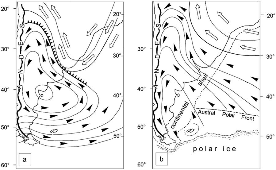
Figure 10 Wind circulation over Argentina. (a) The present-day circulation in a surestada situation: the black arrows indicate the polar wind, the white arrows represent the tropical wind. (b) The proposed wind circulation during the glacial times, according to the situation of polar ice and polar front as described by several authors.
The deflation of the calcareous dust and its transport over thousands of kilometres on the continent by strong and dry winds sweeping over the desertic plains covered by glaciofluvial deposits fits this context well. Under long-lasting cryogenic conditions, rock debris suffers comminution to the 50–10 µm silt grain size (Konishchev, Reference Konishchev1982). Quartz is the most fragile because its microfissures are about 1–10 µm apart and can be reduced to the limiting size of solid particles, about 1 µm (Schwamborn et al., Reference Schwamborn, Fedorov, Ostanin, Schirrmeister and Andreev2012). This grain size is well adapted for wind deflation and explains the fineness of the glacial dust observed in Argentina and also collected in the Antarctic ice. Petit et al. (Reference Petit, Jouzel, Raynaud, Barkov, Barnola, Basile and Bender1999), Legrand et al. (Reference Legrand, Lorius, Barkov and Petrov1988), Jouzel et al. (Reference Jouzel, Barkov, Barnola, Genthon, Korotkevitch, Kotlyakov and Legrand1989), Kotlyakov et al. (Reference Kotlyakov, Nikolayev, Korotkevich, Petrov, Barkov, Lipenkov and Lorius1991), Fischer et al. (Reference Fischer, Fundel, Ruth, Twarloh, Wegner, Udisti and Becagli2007), and Reader et al. (Reference Reader, Fung and McFarlane2012) evaluated the amount of dust in the atmosphere during the cold periods to be at least 15 times more than the amount seen now, because the wind was so much stronger. Delmonte et al. (Reference Delmonte, Petit, Basile-Doelsch, Jagoutz and Maggi2007) estimated that dust fluxes during the last five interglacials were reduced 10- to 25-fold compared with dust fluxes occurring during glacial periods.
The geographic source of the dust contained in the Antarctic ice has been often assumed as derived from southern South America (Basile et al., Reference Basile, Grousset, Revel, Petit, Biscaye and Barkov1997; Delmonte, Reference Delmonte2003; Delmonte et al., Reference Delmonte, Basile-Doelsch, Petit, Maggi, Revel-Rolland, Michard, Jagoutz and Grousset2004, Reference Delmonte, Andersson, Baroni, Petit, Hansson, Albani, Maggi and Frezzotti.2011; Fischer et al., Reference Fischer, Fundel, Ruth, Twarloh, Wegner, Udisti and Becagli2007; Li et al., Reference Li, Ginoux and Ramaswamy2008). According to Ackert (Reference Ackert2009), most of the dust in the Antarctic ice cores came from the glacial outwash of Patagonia. Sugden et al. (Reference Sugden, McCulloch, Bory and Hei2009), Albani et al. (2010, Reference Albani, Mahowald, Delmonte, Maggi and Winckler2011), and McCulloch et al. (Reference McCulloch, Bentley, Purves, Hulton, Sugden and Clapperton2000) also considered South America to be the main source for the dust during the LGM, because of the extension of glaciogenic dust sources on active outwash plains, as well as a likely more efficient transport to West Antarctica. Delmas and Petit (Reference Delmas and Petit1994), Kaiser and Lamy (2010), and Weber et al. (Reference Weber, Kuhn, Sprenk, Rolf, Ohlwein and Ricken2012) emphasised the role of the emerged shelf. Li et al. (2010) considered that the extension of the dust source caused by the lower sea level was two to three times greater than that due to the reduction of continental vegetation. Dust transported from Patagonia and even from La Pampa can be well explained by the counterclockwise shift of the southeasterly winds once stopped by the Andes chain.
By analogy with satellite observation of current dust plumes, Gaiero (Reference Gaiero2007), Gaiero et al. (2004), and Delmonte et al. (Reference Delmonte, Andersson, Schöberg, Hansson, Petit, Delmas, Gaiero, Maggi and Frezzotti2010) suggested that the Bolivian Altiplano could also represent a potential geographic source. This option is debatable when considering the environment during the glacial periods. The Altiplano was wetter than today during the LGM (Baker et al., Reference Baker, Seltzer, Fritz, Dunbar, Grove, Tapia, Cross, Rowe and Broda2001). Consequently, glaciers developed not only on the mountain chains, but also on the northern Altiplano (Mark et al., Reference Mark, Seltzer and Rodbell2004), and wide palaeolakes formed (Clayton and Clapperton, Reference Clayton and Clapperton1995; Clapperton et al., Reference Clapperton, Clayton, Benn, Marden and Argollo1997; Moon, Reference Moon2008). These lakes were frozen during winter and melted in summer. There were not enough barren surfaces to supply dust towards Antarctica, and it is difficult to identify the wind circulations that would have been responsible for the transfer.
CONCLUSIONS
Field observations as well as laboratory analyses prove that the calcareous dust associated with Pleistocene periglacial features of central and southern Argentina is of glacial origin, transported by and precipitated from river waters over the alluvial plains to the emerged continental shelf, where it recrystallised and was deflated and dispersed by winds during the cold episodes. The observations detailed herein provide also information about the environment during the glacial periods. The role of reinforced Antarctic southeasterly winds, for instance, was minimised in previous publications, whereas it has been asserted in the southeastern Atlantic (Kim et al., Reference Kim, Schneider, Mulitza and Müller2003). Alternatively, the calcareous concentrations in soils of central and northern Argentina could have resulted from secondary precipitation of CaCO3 after weathering under warmer and wetter postglacial conditions.
ACKNOWLEDGMENTS
One of us, T. Vogt, did the fieldwork with A. Corte and H. Vogt, both of whom have since passed away. We remember the animated discussions in the field and the outcomes that we report here. We also acknowledge the field organisation and cooperation of the teams of CENPAT in Puerto Madryn and the University of La Pampa in Santa Rosa. And we are grateful to the senior editor and to the two reviewers whose remarks and suggestions helped to improve our text.