


INTRODUCTION
In the Chaudière River valleyFootnote 1 of southeastern Québec, a series of sections exposing glacial and interglacial sediments along Chaudière River tributary, Rivière des Plante, and along the Rivière des Plante tributary, Rivière Fraser (Fig. 1 and 2), comprise the most complete and well-constrained exposures of Appalachian glacial stratigraphy in Canada. Stratigraphic sections exposed along these rivers were described and sampled in conjunction with a major stratigraphic drilling program, during which more than 40 boreholes were drilled to bedrock by the Geological Survey of Canada in the Chaudière Valley and its tributary valleys in 1968, 1985, and 1986 (Shilts and Smith, Reference Shilts and Smith1986a, Reference Shilts and Smith1986b; Shilts et al., Reference Shilts, Caron and Lamothe2007). Data from the cores from deep boreholes drilled to bedrock through the glacial deposits of Rivière Noire and Rivière Gilbert, tributaries of Chaudière River that parallel Rivière des Plante, as well as previously published and unpublished work on other sections in the Chaudière River basin, complement the data from the des Plante and Fraser sections.
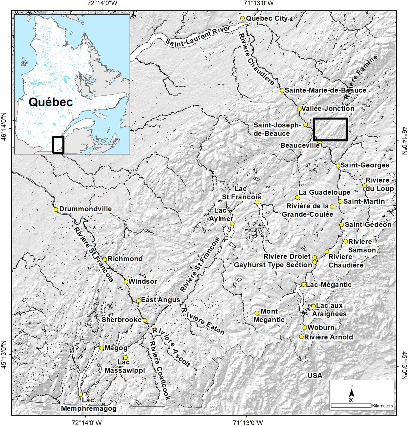
Figure 1 (color online) Topography and place names cited in the text. Rectangular area is the location of Figure 2.
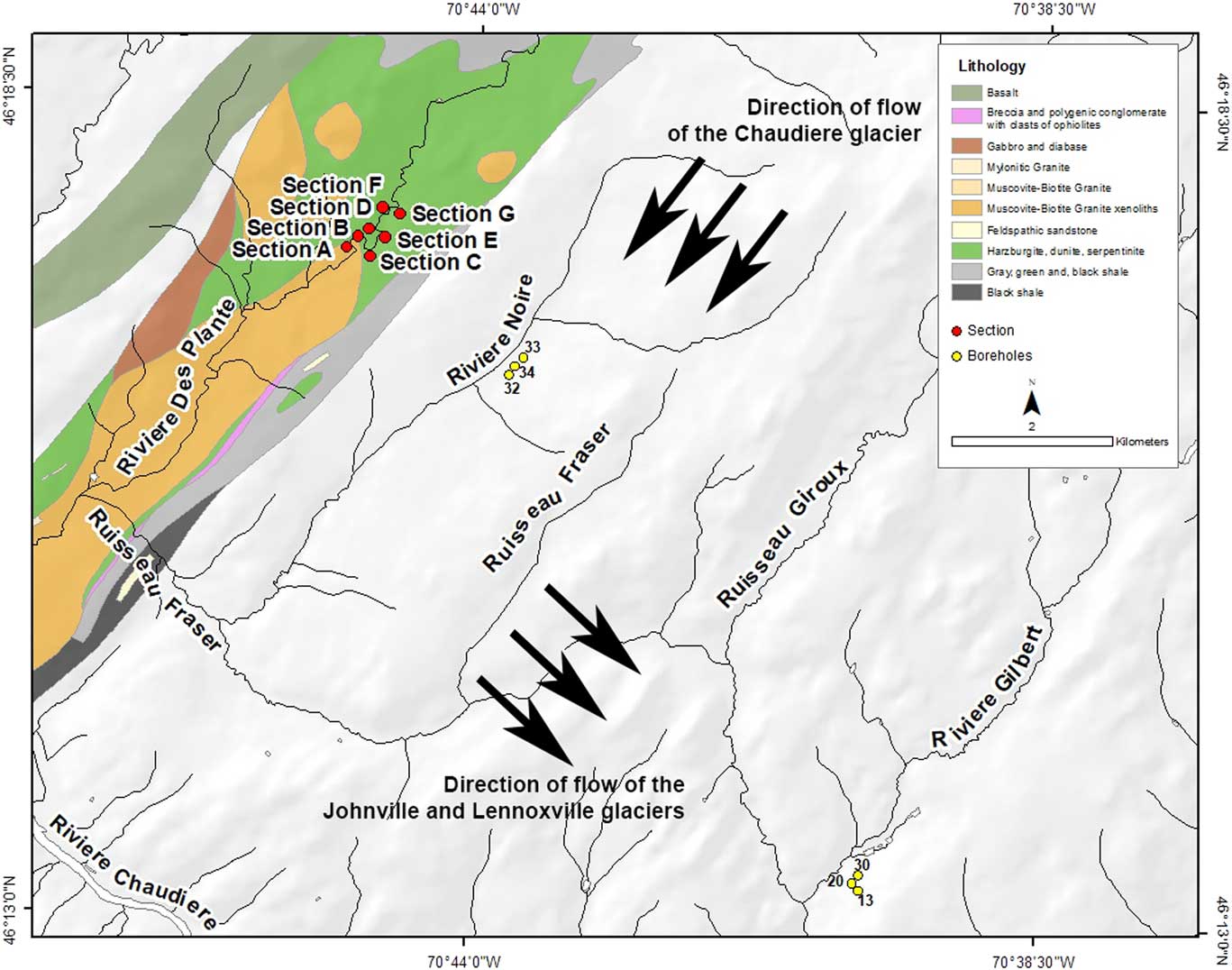
Figure 2 (color online) Generalized geology of known ophiolite outcrops near the Rivière des Plante sections and Rivière Noire and Rivière Gilbert stratigraphic boreholes (Tremblay et al., Reference Tremblay, De Souza, Perrot and Theriault2015).
The sections on Rivières des Plante and Fraser and nearby boreholes along Rivière Noire and Rivière Gilbert exposed or penetrated virtually all of the major Quaternary stratigraphic units previously identified in the Québec Appalachians (McDonald and Shilts, Reference McDonald and Shilts1971), including preglacial saprolite and the first known exposure of in situ interglacial peat and fluvial deposits. Because of the fortuitous locations of the sections and boreholes, among and just southeast of chemically and lithologically distinctive ultramafic bedrock outcrops of the Appalachian ophiolite belt (St-Julien and Hubert, Reference St-Julien and Hubert1975; Cousineau, Reference Cousineau1990; Tremblay et al., Reference Tremblay, De Souza, Perrot and Theriault2015), a variety of compositional constraints can be brought to bear on discussions of the ice-flow directions and events responsible for deposition of the various sediment facies, glacial and nonglacial, that are exposed along the des Plante and Fraser Rivers and encountered in nearby boreholes.
METHODS
From 1985 to 1987, detailed sampling, palynological, and compositional-sedimentological studies were carried out on stratigraphic sections exposed by fluvial erosion along Rivière des Plante and Rivière Fraser. These studies resulted in several reports and two bachelor’s theses that provided preliminary stratigraphic interpretations (Paul, Reference Paul1987; Poliquin, Reference Poliquin1987; Shilts and Smith, Reference Shilts and Smith1986b, Reference Shilts and Smith1988, Reference Shilts and Smith1989; Shilts et al., Reference Shilts, Caron and Lamothe2007; Smith and Shilts, Reference Smith and Shilts1987). The detailed investigation of these sections and of the nearby boreholes were given context and complemented by related regional studies of surficial geology and glacial history of the Beauceville and St. Joseph map areas (Blais, Reference Blais1989; Blais and Shilts, Reference Blais and Shilts1992a, Reference Blais and Shilts1992b).
Although most of the quantitative studies were carried out during the drilling programs of 1985–1986, the Rivière des Plante sections were visited and photographed by one or another of the authors every year from 1984 to 2014. Interpretation of the configuration of the units exposed along Rivière des Plante was initially difficult because of considerable covers of slumped material. The geometry and superposition of the various stratigraphic units, which include what we interpret to be colluvial material that covered a section created during the last interglacial stage by an ancestral Rivière des Plante, were better understood after major flooding in 1988 and 1989. In the river sections, pebble lithology, two-dimensional fabric, particle size distribution, mineralogy, palynology, 14C dating, macropaleontology, and geochemistry (<63 μm and <2 μm size fractions) of till, non-glacial fluvial sediments, and proglacial lacustrine sediments were used to support stratigraphic interpretations.
In boreholes near Rivière des Plante, geochemistry of the <63 μm and <2 μm size fractions and of the fine sand-sized, nonmagnetic heavy mineral (sp gr>3.25) fractions of all sediments were determined in close vertical detail, as was the frequency of visible gold grains (Shilts and Smith, Reference Shilts and Smith1988). Percentage of kaolinite in the clay fraction of several samples was calculated using X-Ray diffraction techniques. Geochemical analyses (inductively coupled plasma mass spectrometry [ICP-MS]) were performed on hot HNO3-HCl (aqua regia) or hot HF-HNO3-HCl “total” (perchloric acid) leachates. The boreholes were drilled using a rotasonic system, which produced 10-cm-diameter cores with little core loss and minimal distortion of bedding structures (Smith and Rainbird, Reference Smith and Rainbird1987). The cores were logged at a central location in the field and sampled during the logging procedure.
Previous stratigraphic studies
In the Appalachian Mountains of southeastern Québec, McDonald and Shilts (Reference McDonald and Shilts1971) first defined the major stratigraphic units of Quaternary sequences in the Chaudière and St. Francois River valleys. They confirmed the original and fundamentally sound stratigraphic observations of Chalmers (Reference Chalmers1898) that led him to similar conclusions about at least the latest glacial events. Chalmers observed artificial exposures made during the extensive gold mining operations that were so common in the region in the late nineteenth century and described a preglacial saprolite that was the primary target for mining. The gold-bearing saprolite has been removed from many river valleys by hydraulic dredging and is not known to be exposed presently either in the Chaudière River valley or in its tributary valleys.
McDonald (Reference McDonald1967) drew on the stratigraphic studies of Stewart and MacClintock (Reference Stewart and MacClintock1964) in Vermont to support his interpretation of the glacial stratigraphy of well-exposed sections on the Ascot River near Lennoxville, Québec, just north of the Vermont-Québec border. In the Ascot River sections, he noted that an overconsolidated till with fabric trending southwest at the base, gradually shifting toward southeast at the top, rested on slightly deformed, silty lacustrine sediments with abundant, finely divided organic debris that yielded a date >54,000 14C yr BP (Y-1683). These sediments rested on a poorly exposed till. McDonald and Shilts (Reference McDonald and Shilts1971) named the poorly exposed till Johnville Till and the lacustrine bed Massawippi Formation, which, because it contained pollen that indicated climate colder than the present, was originally thought to be an early Wisconsinan interstadial deposit. Till overlying the Massawippi Formation was named Chaudière Till, correlative with Stewart and MacClintock’s Shelburne till of northern Vermont. The youngest till in the region, Lennoxville Till (Burlington till in Vermont), also has its type section on the Ascot River, where it has a fabric indicating southeastward glacial flow; it is separated from underlying Chaudière Till by rhythmically laminated lacustrine sediments.
In the Chaudière River valley, laminated sediments of the Gayhurst Formation (McDonald and Shilts, Reference McDonald and Shilts1971) also separate Chaudière and Lennoxville Tills, but are locally very thick (>100 m) and are associated with deltas that define water planes for Glacial Lake Gayhurst, a large lake that filled the Chaudière and St. François River valleys during the time between deposition of the two tills. Glacial Lake Gayhurst had well-defined surfaces at 397 and 429 m above sea level (asl) in the Chaudière Valley (Shilts, Reference Shilts1969, Reference Shilts1981; McDonald and Shilts, Reference McDonald and Shilts1971). Recent infrared stimulated luminescence (IRSL) dating of the deltaic facies deposited in the 397 m level of Glacial Lake Gayhurst at the type section of the Gayhurst Formation yielded Marine Oxygen Isotope Stage (MIS) 3 ages of approximately 45,000 yr (Caron, Reference Caron2013), the only absolute age with which the stratigraphy described here can be constrained.
Role of nickel and clay mineralogy in constraining stratigraphic interpretations in the Québec Appalachian region
Because Ni, Cr, Mg, Fe, and Co are highly enriched in ultramafic bedrock compared with average crustal concentrations, glacial erosion of the ultramafic complexes of the ophiolite belt (Cousineau, Reference Cousineau1990; Tremblay et al., Reference Tremblay, De Souza, Perrot and Theriault2015) imparted anomalous concentrations of these elements to till and related sediments for significant distances along glacial flow paths, regardless of the topography or drainage basin configuration. Shilts (Reference Shilts1973) first published maps of the areal distribution of nickel and related ultramafic components in sediments deposited by the last, southeastward-flowing Laurentide Ice Sheet that traversed ultramafic outcrops of the Québec Appalachians. In this and subsequent publications, he and his colleagues demonstrated how the dispersal patterns of these components could be used to constrain and interpret the depositional processes and ice-flow trajectories of the various continental glaciers that flowed across the region (Shilts and McDonald, Reference Shilts and McDonald1975; Shilts, Reference Shilts1976, Reference Shilts1978, Reference Shilts1981; Rencz and Shilts, Reference Rencz and Shilts1980; Parent, Reference Parent1987; Blais, Reference Blais1989; Courtney, Reference Courtney1989; Shilts and Smith, Reference Shilts and Smith1989).
In individual stratigraphic sections in the dispersal areas, the composition of glacial sediments reflects the extent to which their depositing ice derived sediment from kaolinite-rich preglacial saprolite and ultramafic outcrops, if the ice passed over saprolite or ultramafic outcrops at all. Ultramafic bedrock is also enriched in characteristic minerals (magnetite, chromite, serpentine, asbestos, and related minerals) and is the source of ultramafic clasts (serpentinized peridotite), all of which are equally distinctive provenance indicators.
In this report, we focus particularly on how the variations in clay mineralogy and in nickel concentrations in the fine size fractions of till and associated glacial and non-glacial soils and sediments constrain possible interpretations of Pleistocene history in this sector of the northern Appalachians. Effectively, once a continental ice sheet crossed ultramafic outcrops for the first time, glacial and associated water-lain sediments were irreversibly “contaminated” by nickel and the other elements, minerals, and clasts that are characteristic of ultramafic bedrock for considerable distances down ice. Likewise, the first passage of a continental ice sheet reworked and removed preglacial saprolite, leaving pockets of it preserved only in depressions protected from ice erosion.
PREGLACIAL AND GLACIAL STRATIGRAPHY
In the following sections, the Pleistocene stratigraphy that we have deduced from boreholes and extensive exposures created by fluvial erosion on previously described and new sections in this part of the Appalachian Mountains are integrated with previously published stratigraphic interpretations for the first time. We identify deposits of three major glaciations, separated by non-glacial fluvial and glaciolacustrine sediments, which overlie (where it has not been glacially eroded) a saprolite that is clearly pre-glacial. Figure 3 depicts a typical stratigraphic sequence over bedrock and is based on boreholes and observations during regional mapping programs (Shilts and Smith, Reference Shilts and Smith1988; Blais, Reference Blais1989).
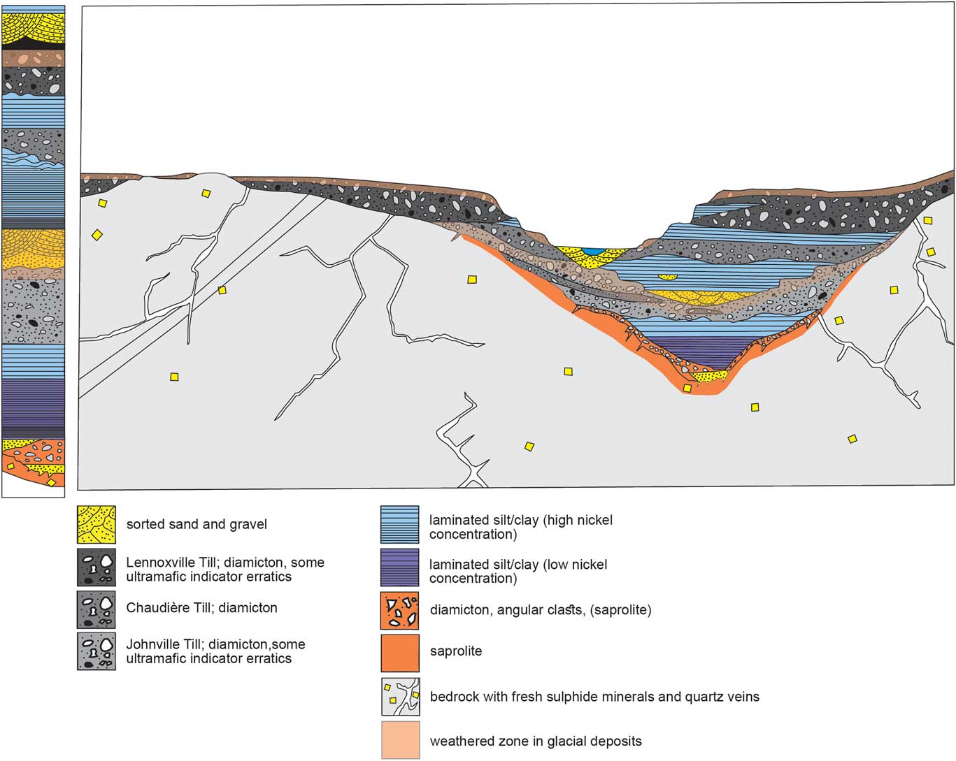
Figure 3 (color online) Schematic cross section depicting the generalized depositional history of the des Plante, Noire, and Gilbert River valleys, based on seismic surveys, boreholes to bedrock, and river exposures (slightly modified from an original by Sharon Smith; Shilts and Smith, Reference Shilts and Smith1988).
Preglacial Saprolite
The saprolite directly overlying pyritiferous slate in most of the boreholes in the Noire and Gilbert River valleys is a yellow-brown, monolithic, diamictic sediment thought to represent remnants of the preglacial saprolite observed elsewhere in the Appalachians (Chalmers, Reference Chalmers1898; LaSalle and Ledoux, Reference LaSalle and Ledoux1975). Historically, this saprolite has been the target for gold exploration in the tributaries of the Chaudière River, and it was exploited underground and by dredgeing in the Rivière Gilbert valley at St. Simon-les-Mines until the mid-1960s.
In samples from boreholes in the Rivière Noire and Rivière Gilbert valleys, the geochemical composition of the saprolite is distinctive, having low concentrations of nickel, typical of average crustal rocks, iron concentrations double those of the overlying glacial sediments, and relatively high arsenic concentrations that are typically associated with gold-bearing deposits in bedrock (Shilts and Smith, Reference Shilts and Smith1988; Fig. 4). Glacial sediments of the Appalachians characteristically have diverse species of sand-sized heavy minerals, derived in large part from the Canadian Shield, but the heavy mineral suite in the saprolite consists exclusively of rare flakes of gold, cube-shaped limonitic pseudomorphs after pyrite, secondary siderite, and amorphous limonite.

Figure 4 Nickel concentrations, lithology, and interpreted stratigraphy of boreholes drilled across the Rivière Gilbert valley. Unaltered bedrock at the base of the boreholes is black slate.
The saprolite is also rich in kaolinite (Shilts and Smith, Reference Shilts and Smith1988), a clay mineral that is not normally encountered in glacial sediments and soils of the region (Dean, Reference Dean1969; Shilts, Reference Shilts1978, Reference Shilts1981), except in Johnville Till (see below), which contains reworked saprolite. Air-dried, untreated X-ray diffraction traces of the clay (<2 μm) fraction of the saprolite reveal a mineralogy dominated by quartz with poorly crystallized chlorite/kaolinite and mixed-layer clay minerals; clay-sized fractions lack the well-defined first- and second-order chlorite peaks typical of overlying glacial and proglacial sediments (Shilts, Reference Shilts1978; Shilts and Smith, Reference Shilts and Smith1986a, p. 276).
Pre-Johnville lake sediments
In boreholes in the Gilbert River valley (Fig. 2), southeast of the ophiolite belt, distinctive, yellow-orange saprolite is overlain directly by laminated lacustrine silty clay (Shilts and Smith, Reference Shilts and Smith1986b). The lower parts of the lacustrine deposits at Rivière Gilbert have nickel concentrations comparable to but slightly higher than those in the underlying saprolite (Fig. 4). The saprolite high arsenic and iron concentrations, however, are not repeated in the lacustrine sediments (Shilts and Smith, Reference Shilts and Smith1988).
About 15 m above the base of the lacustrine sequence at Rivière Gilbert, the texture of the lacustrine sediments becomes distinctly more silt- and sand-rich. Above this textural boundary, concentrations of nickel in the clay fraction of the sediments increase abruptly to levels five or more times those in the lower facies (Fig. 4). This abrupt enrichment is thought to be the manifestation of erosion by the first continental ice sheet to pass over the Rivière des Plante ophiolite outcrops to the north, producing nickel-rich rock flour that was dispersed southward by meltwater as suspended sediment in a lake dammed in the Chaudière Valley and its tributary valleys by an advancing glacier. This interpretation implies that these laminated sediments represent the first Pleistocene deposits related to the presence of glaciers in this sector of the Appalachian Mountains.
In boreholes on Rivière Noire, the saprolite is also overlain by an undeformed, laminated lacustrine sequence beneath till, but the nickel concentrations in the lake sediments are uniformly below 100 ppm, with no evidence of the sharp increase noted in the Rivière Gilbert cores (Smith and Shilts, Reference Shilts and Smith1987).
At Rivière des Plante, highly deformed, overconsolidated, clay-rich, laminated lacustrine sediments crop out at the bases of sections A and B. The deformation is so pervasive that these sediments have the appearance of a massive silt-clay, but at the downstream end of section A, the clay resolves itself into nearly horizontal silt-clay laminae (Fig. 5). Post-Johnville fluvial and organic beds of the Massawippi Formation overlie these sediments unconformably. Given the geometry of other parts of the exposures and the fact that the substantial thickness of Massawippi glaciolacustrine beds was not deformed during subsequent Chaudière glaciation (Fig. 6), the clay must have been deformed during an earlier glaciation, presumably by the glacier that deposited the Johnville Till. Johnville Till was exposed in an excavation physically above the clay in section B.

Figure 5 (color online) Undeformed pre-Johnville glaciolacustrine sediments into which fluvial channels have been cut and filled by coarse interglacial Massawippi Formation fluvial gravel, base of section A, Rivière des Plante. The horizontal bed above the fluvial gravel is a sandy silt that is interpreted as a flood plain deposit. It contains numerous flattened fragments of wood (arrow). The laminated silty clay into which the channel is cut is pre-Johnville lacustrine facies that forms the base of Sections A and B; it is highly deformed and appears massive at the base of both sections, except for the downstream end of Section A, depicted here, where it resolves itself into slightly deformed laminae.

Figure 6 (color online) Undeformed, distal laminated lacustrine facies of the Massawippi formation, exposed above the fluvial and floodplain facies of section B, Rivière des Plante. These laminae contain ice-rafted debris, overlie fluvial gravel and colluvium, and are directly overlain by Chaudière Till. The contact with Chaudière Till is at the very top of the exposure.
The deformed Rivière des Plante lacustrine sediments are thought to be correlative with the undeformed laminated sequences encountered over the saprolite and beneath Johnville Till in boreholes on the Noire and Gilbert Rivers.
Figure 7 depicts our interpretation of the complicated geometry of the units in sections A and B. The interpretation depicted here accounts for what we have observed directly after various flood events and what we interpret to be the configuration of hidden units to account for deformation of the lower lacustrine sequence.

Figure 7 Till fabric, nickel concentration, and interpreted stratigraphy of Section B, Rivière des Plante.
Johnville Till
At Rivière des Plante and in the boreholes nearby, Johnville Till is presumed to have been deposited by a southeastwardly flowing continental ice sheet, as it was elsewhere in the Chaudière and St. François Valleys (McDonald and Shilts, Reference McDonald and Shilts1971; Shilts, Reference Shilts1981). That assumption is confirmed by till fabric measurements and compositional data. Johnville Till is or was well-exposed in sections D–G, and, as noted above, was at one time exposed in a “window” through slump deposits near the base of section B (Fig. 7), where it is physically above, but cannot be observed to be directly in contact with, intensely deformed lake sediments. Where exposed in section D and where sampled at the base of the boreholes on Rivière Gilbert, Johnville Till is a yellow-brown, matrix-supported, heterolithic diamicton with a relatively high clast-to-matrix ratio (Fig. 8). On Rivière des Plante, more than 40% of its pebble- and cobble-sized clasts are distinctive serpentinized peridotite derived from outcrops that are mapped at various places within hundreds of meters of the sections (Fig. 2; Cousineau, Reference Cousineau1990; Tremblay et al., Reference Tremblay, De Souza, Perrot and Theriault2015). A fabric measured in Johnville Till at section D had a preferred orientation striking northwest-southeast, similar to fabric measured in presumed Johnville Till in section E.

Figure 8 (color online) Sharp contact between intercalated slabs of Johnville Till (brown) and Chaudière Till (gray) at the base of section D. Note the strong contrast in nickel concentrations in the <2μ fractions of the two tills.
Johnville Till in the limited exposure through modern slump deposits near the base of section B (Fig. 7) has a northwest-southeast-trending fabric and the till was observed to be highly enriched in nickel (1720 ppm, 1940 ppm in the <2 μm fraction). It is overconsolidated, gray, and sandier than at section D.
At section D, Johnville Till is found as dipping plates of diamicton intercalated with gray, unoxidized plates of Chaudière Till (Fig. 8). As in the boreholes on Rivière Gilbert, it is yellow-brown or tan. Its clay-sized fraction contains 10% to 15% kaolinite (de Kimpe, C., personal communication, 1988), a component derived from reworking of the kaolinite-rich, preglacial, gold-bearing saprolite that covered the preglacial landscape.
In nearby Rivière Gilbert and Rivière Noire boreholes, which were drilled through the saprolite to bedrock, till lying on the lake sediments that rest directly on the saprolite has a similar tan or brown color and contains abundant kaolinite, apparently incorporated into its matrix by glacial reworking of the saprolite. In addition to a varied suite of silicate heavy minerals, the sand fraction of Johnville Till sampled from these boreholes contained both fresh pyrite and the limonitic pseudomorphs after pyrite that typically occur in the saprolite.
The color and composition of Johnville Till at section D and in the Rivière Gilbert boreholes and the presence of kaolinite suggest that the glacier that deposited it both removed and incorporated saprolite that covered the preglacial landscape.
Massawippi Formation interglacial deposits
The Masssawippi Formation lies directly beneath Chaudière Till and stratigraphically above Johnville Till in Rivière des Plante sections A and B. These exposures are the only known sites in the Québec and New England Appalachians that comprise a sequence of nonglacial and proglacial sediments deposited during an interglacial stage. At the base of section A, a bed of compact, wood-bearing, sandy (floodplain) silt lies on a variable thickness of clast-supported cobble gravel. The gravel fills shallow channels cut into the massive, deformed and overconsolidated silty clay described above (Fig. 5). It contains rounded cobbles of serpentinized peridotite that are so highly weathered that they disintegrate at the touch.
In sections A and B, the deformed and highly compacted clay is interpreted as pre-Johnville lacustrine sediment (see discussion above) and forms the base of the sections from end to end. At the base of section B, its upper surface is also sculpted into shallow channels filled with fluvial cobble gravel and a clast-supported diamicton, thought to be Masssawippi-age colluvium or slump with minor lenses of sorted gravel.
Near the base of Section B, a bed of highly compressed peat, varying from <1 to 30 cm in thickness is completely enclosed within and near the middle of the 2- to 4-m-thick, clast-supported diamicton that overlies the highly deformed pre-Johnville silty clay. A 14C date obtained on a stick isolated from this peat yielded an age of >53,000 14C yr BP (GSC-4728 HP).
Examination of organic detritus from the peat bed led Matthews (Reference Matthews1987, p. 170) to state that it contained “a rich fossil insect and plant assemblage that clearly resembles St. Pierre assemblages from the classic localities.” He concluded that when the Massawippi peat was being deposited, probably near the end of the Massawippi (Sangamon [MIS 5] interglacial) interval, this part of Québec was covered by tundra and a spruce forest that contained some larch and a species of Alnus typical of northern boreal forests. Matthews, et al. (Reference Matthews, Smith and Mott1987) suggest that pollen in interglacial deposits at Rivière des Plante and in boreholes throughout the region reflect colder conditions than those from the St. Pierre beds 100 km to the north, in the St. Lawrence Lowlands. They also contain a larger number of insect taxa than do the classic St. Pierre localities, including several northern species that do not presently occur in southern Québec. Matthews et al. (Reference Matthews, Smith and Mott1987) suggest that interglacial sediments at Rivière des Plante and in regional boreholes were deposited during cold conditions associated with the onset of Chaudière glaciation.
This conclusion is at odds with the assumption by McDonald and Shilts (Reference McDonald and Shilts1971) that the Massawippi Formation represents a cold, post-MIS 5 interstade. The present authors agree with Matthews (Reference Matthews1987) and Matthews et al. (Reference Matthews, Smith and Mott1987) that the cold climate indicators in these and other Massawippi-age sediments reflect a cool-down associated with the onset of post-MIS 5 glaciation, and are not the deposits of an early Wisconsinan interstade.
Macrofossils isolated from the peat exposed in Section B were examined by Ovenden in 1988. She (Ovenden, Reference Ovenden1988) stated, “[a]ll of the plants…are common in boreal fens, and occur in a broad latitudinal zone from northern New England to northern Québec. The lack of diversity and the interwoven, highly organic nature of the peat indicates [that it is] an in situ peat deposit. The mosses suggest a fairly calcareous, groundwater fed wetland, and the abundance of needles and wood suggests that larch and black spruce occurred in the fen.” This peat is significant in that it is the first sub-till, in situ peat deposit found in the glaciated Appalachian Mountains and represents nonglacial, subaerial conditions at this site during deposition of the Massawippi Formation. All other organic sites in the Appalachians are in glaciolacustrine or fluvial environments, and much, if not all, of the organic detritus at those sites is allochthonous.
Along the upper surface of a prominent thrust plate at section D, moss and other organic detritus is interbedded with glaciolacustrine silt laminae in a band <1 cm thick. The palynology of this band is similar to that of the organic layer at section B. This material is deformed in contact with a detached mass of fluvial gravel similar to the gravel at section A (Fig. 5).
Organic remains in the glaciolacustrine sediments that overlie the peat-bearing colluvium at section B contain evidence of arctic flora and fauna, as do organic horizons in Massawippi (?) glaciolacustrine sediment in nearby exposures at Vallée-Jonction (LaSalle et al., Reference LaSalle, Martineau and Chavin1977) and colluvial deposits at Rivière de la Grande Coulée (McDonald and Shilts, Reference McDonald and Shilts1971; Shilts, Reference Shilts1981; Matthews et al., Reference Matthews, Smith and Mott1987). Tundra conditions apparently prevailed in this area as the Chaudière glacier impinged on local drainage, ponding lakes in the Chaudière River drainage basin.
Overlying the peat-bearing colluvium (section B) and alluvium (section A) is a thin-bedded, laminated silty clay. Where well-exposed in section B (Fig. 6), this unit can be seen to contain small (<1-cm-diameter) dropstones and balls of till in its upper laminae. The laminated sequence is overlain with sharp contact by Chaudière Till. The laminated sequence is also well-preserved at section A, but at section D it is highly deformed and forms a discreet, wedge-shaped slab of sediment within tectonized Chaudière Till (Fig. 9).
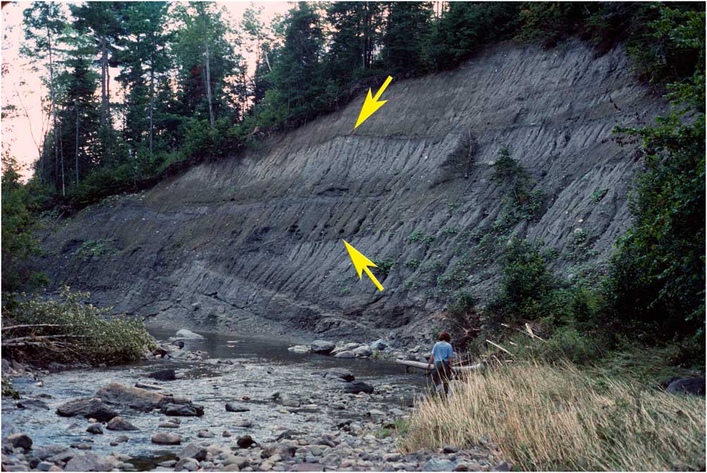
Figure 9 (color online) Horizontally bedded, laminated sediments of the Gayhurst Formation overlying with angular unconformity the tectonized Johnville Till/Chaudière Till/Massawippi Formation complex at the base of section D (the lower arrow points to the contact). Also note the arched upper surface of Lennoxville Till, section D (upper arrow); the upper part of the section, above the arched surface, is a flow till/laminated silt-clay sequence, similar to the Lennoxville Till complexes in the upper parts of sections A and B.
The fact that the Massawippi laminated sediments and underlying fluvial and floodplain sediments are largely undeformed precludes any causal association of Chaudière glaciation with deformation of the lacustrine sediments that they overlie. Therefore, the laminated sediments must have been deformed during a glaciation preceding the Chaudière, presumably the Johnville glaciation.
Chaudière Till
Chaudière Till forms a prominent bed across sections A and B, where it lies with a sharp, horizontal contact on the largely undeformed, upper glaciolacustrine member of the Massawippi Formation. In section D, it is intercalated with Johnville Till and deformed Massawippi fluvial gravel and laminated sediment in a series of thrust plates (see discussion above; Fig. 8 and 9). In sections A, B, and D, Chaudière Till ranges in color from gray to gray with a maroon tint and is visually distinguishable from Johnville Till in section D by virtue of the yellow-brown color of the latter.
Two-dimensional fabrics measured in Chaudière Till at sections A and B strike for the most part north-northeast–south-southwest (Poliquin, Reference Poliquin1987; Fig. 7). In section D, the entire Chaudière and pre-Chaudière sediment sequence is intercalated in thrust plates (Fig. 9) dipping toward 005°, a direction compatible with the maxima of Chaudière Till fabric measured in sections A and B and elsewhere in southeastern Québec (McDonald and Shilts, Reference McDonald and Shilts1971).
Chaudière Till at Rivière des Plante and in nearby boreholes does not contain components derived from the saprolite that underlies Johnville Till, supporting the conclusion that the Johnville Glaciation stripped saprolite from all but the most protected depressions on the preglacial landscape. Chaudière Till is impoverished in nickel and ultramafic clasts compared with underlying Johnville Till and overlying Lennoxville Till, even though its outcrops may be within hundreds of meters of mapped ophiolite bodies. This is probably because the locations of these exposures are at sites where, in contrast to the southeast flow directions of the Johnville and Lennoxville glaciers, the trajectory of Chaudière ice flow was such that ice did not pass over outcrops of ultramafic bedrock.
As elsewhere in the region (Shilts, Reference Shilts1978; Shilts; Reference Shilts1981), compositional evidence provides strong support for ice flow from a non-Laurentide source during at least part of the Chaudière Glaciation. Here, as elsewhere in southeastern Québec, fabric and composition of Chaudière Till is taken as evidence of growth of an independent Appalachian ice cap in the Maine and/or New Brunswick highlands, followed by displacement of part or all of the ice cap by a much more robust, southeastwardly advancing Laurentide continental glacier (McDonald, Reference McDonald1967; Shilts, Reference Shilts1970; McDonald and Shilts, Reference McDonald and Shilts1971; Shilts, Reference Shilts1978, Reference Shilts1981).
Poliquin (Reference Poliquin1987) has suggested that the few Canadian Shield erratics in Chaudière Till at Rivière des Plante could have been transported southward from the Shield during the Laurentide phase of Chaudière glaciation.
Gayhurst Formation
At section D, the irregular surface of the tectonized lower part of the section is overlain with sharp angular unconformity (Fig. 9) by horizontal, gray, laminated sediments of the Gayhurst Formation (McDonald and Shilts, Reference McDonald and Shilts1971; Shilts, Reference Shilts1981; Caron, Reference Caron2013). The lowest outlet of Glacial Lake Gayhurst was at an altitude of approximately 294 m asl, well above the altitude of these sections. Consequently, only laminated sediments of the deep-water facies of the Gayhurst Formation were deposited in this area.
Lennoxville Till
Lennoxville Till is the main last glacial maximum (LGM) glacial deposit in Québec and New England and caps sections A–D. It is gray, weathering brown or tan, cobbly till with some lenses of gravel and numerous subhorizontal partings that give it a fissile appearance.
Lennoxville Till has fabric reflecting the southeastwardly flow direction of its depositing Laurentide glacier, and, like Johnville Till, it is rich in ultramafic clasts and geochemical indicators. Paul (Reference Paul1987) divided the Lennoxville Till into upper and lower members at sections B and D on the basis of the presence of water-lain sediments that occur as continuous bands in the middle of the Lennoxville sequence in both sections. At section B, a 2-m-thick complex of laminated silty clay, sand, diamicton lenses, and carbonate-cemented gravel separates two ± 7-m-thick till beds. At section D, the two beds of Lennoxville Till are separated by 3 to 4 m of laminated silt and sand with diamicton layers.
There is no obvious physical or compositional difference between the upper and lower members of Lennoxville Till, and it is possible that the upper member was released on water-lain sediments that were deposited in an ephemeral subglacial lake beneath the Lennoxville glacier. Alternatively, it may have been deposited by a late-glacial readvance southward and southeastward from the St. Lawrence Valley; striation evidence in the Etchemin Valley (Shilts et al., Reference Shilts, Caron and Lamothe2007), ice-contact stratified deposits and till overlying deformed lacustrine sediments in the Chaudière Valley (Blais, Reference Blais1989), and nearby Fraser River section (see discussion below) are interpreted as evidence of such a readvance.
Fraser River section; post-Lennoxville sediments
A 5- to 6-m-high section cut into a broad alluvial plain exposes multiple glacial and nonglacial units and extends southward about 500 m upstream along the east bank of Fraser River from its confluence with Rivière des Plante (Fig. 10). At the confluence, at least 2 m of hard gray Lennoxville Till with discontinuous, 2- to 15-cm-thick, deformed inclusions of laminated silt-clay is conformably overlain by a massive 20- to 30-cm-thick red clay, which is, in turn, overlain by thinly laminated, gray silty clay with red clay layers.

Figure 10 (color online) Fraser River section. Gray Lennoxville Till at river level is overlain by several centimeters of massive red clay, which is overlain, in turn, by laminated glaciolacustrine sediment.
On Rivière Fraser, the surface of the compact, grey, unoxidized Lennoxville Till dips gently southward, upstream, eventually disappearing below river level. It is overlain conformably throughout its exposure by the massive red clay beneath silt-clay laminae. Upstream from where the gray till disappears, the laminated sequence is more than 2 m thick, and individual laminae are deformed progressively upward until they pass into a massive clay with few clasts and some blocks or wisps of laminated sediment (Fig. 11).

Figure 11 (color online) The undeformed, laminated silt clay of Figure 10 passes upward into glaciotectonically deformed clay and clay till. Close-up photograph of pervasively deformed laminated silt-clay. The inset shows detail of deformed laminae just below the pervasively deformed clay and clay till.
The front of the remnant Lennoxville glacier ice mass, left in the Appalachians after a late glacial calving bay in the lower St. Lawrence Estuary isolated it, retreated south to the Québec Ice Divide near Saint-Georges-de-Beauce, about 50 km south of the Rivière des Plante and Rivière Fraser sections (Gadd et al., Reference Gadd, McDonald and Shilts1972; Lortie and Martineau, Reference Lortie and Martineau1987; Smith and Shilts, Reference Smith and Shilts1987; Shilts, et al., Reference Shilts, Caron and Lamothe2007).
The massive red clay and overlying laminated silt-clay are thought to have been deposited in a proglacial lake, dammed by Laurentide ice that readvanced southward, into the Appalachian highlands and up the Chaudière and Etchemin Valleys, while the north terminus of northward-flowing, remnant ice was still retreating to the Québec Ice Divide, or after the remnant ice mass had disappeared altogether.
Abundant erosional (striation) evidence for a southeastward readvance after the retreat of northward-flowing ice is recorded northeast of the Rivière des Plante area, in the Rivière Etchemin valley (Shilts et al., Reference Shilts, Caron and Lamothe2007), but no unequivocal erosional evidence has been found to support such a readvance in the Chaudière Valley itself. Nevertheless, deposits of ice-contact gravel in the Chaudière valley as far south as Saint-Georges and the massive esker-subaqueous fan deposit at Vallée-Jonction (Smith and Shilts, Reference Smith and Shilts1987; Blais, Reference Blais1989; Shilts et al., Reference Shilts, Caron and Lamothe2007) have southward current indicators (Blais, Reference Blais1989), confirming their deposition in contact with a southward-flowing ice lobe.
Blais (Reference Blais1989) also noted several sections in the Chaudière Valley where a till overlies laminated sediments that rest on Lennoxville Till. These deposits are flanked by bedrock terrain with abundant striation evidence that the last glacial flow recorded on the highlands through which the Chaudière River is incised was northward as the remnant Lennoxville glacier front was retreating to the Québec-North Maine Ice Divide (Lowell and Kite, Reference Lowell and Kite1986; Smith and Shilts, Reference Smith and Shilts1987; Blais, Reference Blais1989; Shilts et al., Reference Shilts, Caron and Lamothe2007).
Significance of pre-Johnville fluvial deposits exposed along the Rivière de la Grande Coulée
From the above descriptions of sedimentary sequences in the Rivière des Plante region and the records from over 40 boreholes to bedrock in the region (Shilts and Smith, Reference Shilts and Smith1986a, Reference Shilts and Smith1986b), it is evident that we believe that glaciation of this part of the Appalachians postdates MIS 7. However, the significance of a substantial fluvial deposit that forms the base of the nearby Rivière de la Grande Coulée section, exposed by flood erosion after the original description of its deposits (Shilts, Reference Shilts1981), is difficult to understand in that context, underlying as it does units interpreted as Johnville Till (MIS 6) and Massawippi Formation (MIS 5).
The first author (Shilts, Reference Shilts1981) found rare crystalline clasts that could have been transported from the Canadian Shield and Caron (Reference Caron2013) also observed granite gneiss clasts, typical of Shield lithologies, in these fluvial deposits. Because Appalachian rivers drain northward toward the Shield, the only way that Precambrian erratics could be transported southward into their valleys is by glacial action. The fact that the ancestral Grande Coulée River was aggrading is also difficult to explain unless a glacial event raised base level in the lower Chaudière-St. Lawrence system approximately 188,000 yr ago, if an IRSL age for the sediments is to be accepted (Balescu et al., Reference Balescu, Lamothe, Auclair and Shilts2001). At present, it is not known how the lowermost fluvial sediments at the Grande Coulée section relate to the borehole stratigraphy and stratigraphic exposures elsewhere in the Chaudière drainage basin.
We also recognize that multiple advances of continental glaciers much older than MIS 6 are mapped in the American Midwest (see Rovey II and McLouth, Reference Rovey and McLouth2015) and are reported in northern New Jersey and elsewhere in eastern New York and New England. Since any ancestral Laurentide continental ice sheet would have passed over the Chaudière and adjacent drainage basins before terminating in New Jersey, the lack of any pre-MIS 6 glacial deposits in Québec is presently unexplained. Our observations are at odds with the generally accepted view that early Laurentide continental glaciation reached as far south as New York, New England, and New Jersey (Stanford, Reference Stanford1993; Stone et al., Reference Stone, Stanford and White2002; Ridge, Reference Ridge2004; Stanford and Witte, Reference Stanford and Witte2017). Likewise, there are almost certainly no deposits in this region that are as old as the several pre-MIS 6 glaciations documented in the Midwestern United States.
CONCLUSIONS
Kaolinite-rich, gold-bearing, preglacial saprolite is preserved in many valleys tributary to the Chaudière River. High concentration of kaolinite in the saprolite and its lack of a diverse heavy mineral assemblage, both of which are common to all glacial sediments deposited by the last and ancestral Laurentide Ice Sheets, indicate that no glaciation preceded or was associated with its formation.
Fine-grained, laminated sediments resting directly on the saprolite and overlain by till in the valleys of Rivière Gilbert and Rivière Noire were deposited in a proglacial lake dammed by the first continental ice sheet to advance into the Chaudière River valley, damming the river and its tributaries for the first time. The lower several meters of the laminated sequence are characterized by low nickel concentrations characteristic of the underlying saprolite. An abrupt, two- to sixfold increase in nickel concentration in the upper few meters of the lacustrine beds represents meltwater input of fine-grained glacial sediment created by erosion associated with glacial scouring of the nickel-rich Rivière des Plante ophiolite complex northwest of the boreholes; no glaciation preceded deposition of these glaciolacustrine sediments.
An ancestral Laurentide Ice Sheet that flowed southeastwardly over the Rivière des Plante and nearby valleys, reworking iron and kaolinite-rich preglacial saprolite and proglacial lacustrine laminated clay, deposited Johnville Till, the first sediment released directly from glaciers in this region. The ice sheet eroded serpentinized peridotite outcrops in the Rivière des Plante valley, creating till and associated water-lain sediments with chemical, lithological, and mineralogical compositions uniquely associated with peridotite. The Johnville glacier reworked the preglacial saprolite and scoured it from all surfaces except the most protected parts of deeper valleys.
The Massawippi Formation (MIS 5) is represented in the Rivière des Plante valley by an excellently preserved sequence of fluvial, floodplain, peat, and colluvial deposits that mark a time of free drainage and weathering, followed by boreal to tundra conditions toward the end of the stage. Blockage of Chaudière Valley drainage at the onset of the following Chaudière glaciation resulted in deposition of a substantial thickness of distal, glaciolacustrine laminated sediments, which were draped over the boreal forest and tundra-dominated, late interglacial landscape.
The composition, fabric, and attitude of deformed beds of till at section D on Rivière des Plante support the long-postulated difference in ice-flow history between the glacier that deposited Chaudière Till and those that deposited older Johnville and younger Lennoxville Tills. On Rivière des Plante, Chaudière Till is impoverished in ultramafic components, even though the sections exposing it are located in close proximity to or directly southeast of serpentinized peridotite outcrops.
As elsewhere in the Québec Appalachians, the early stages of Chaudière glaciation are thought to have been associated with coalescing “local” glaciers arising in the Québec-New Brunswick-New England highlands. Eventually, the “local” glaciers are thought to have been overwhelmed, either displaced by or incorporated into the expanding early Wisconsinan Laurentide Ice Sheet.
The LGM, Lennoxville, glaciation is marked throughout southeastern Québec and New England by southward to eastward ice flow; the last Laurentide glacier crossed the highest peaks of the Appalachians from a center of ice flow on the eastern Canadian Shield. Near the Rivière des Plante and Rivière Fraser sections, numerous bedrock outcrops record northward flow following the main southeastward flow phases of the Lennoxville glaciation.
South of the Appalachian front near the end of the Lennoxville glaciation, ice of the retreating Lennoxville glacier was separated from Laurentide ice to the north by the influence of a marine calving bay that progressed up the St. Lawrence depression, redirecting ice flow south of the St. Lawrence valley northward and eastward down the St. Lawrence estuary. Residual ice remaining south of the Appalachian front shrank toward the Québec-North Maine Ice Divide and eventually disappeared. Laurentide ice, resting against the Appalachian front while the remnant ice ablated, briefly thickened, pushing lobes up the major valleys in deep proglacial lakes. Till and related glaciolacustrine laminated sediments exposed along the Fraser River and possibly near the tops of sections along Rivière des Plante were deposited by these readvancing lobes. As the lobes retreated, they slowed or halted several times, building subaqueous fans in the lakes, the most prominent of which was the massive, >100 m accumulation of sand and gravel that blocked the valley completely but briefly at Vallée-Jonction.
The events recorded by the preglacial, glacial, proglacial, and nonglacial deposits exposed on Rivière des Plante and Rivière Fraser and in boreholes on Rivière Gilbert and Rivière Noire include those from one glaciation preceding the last interglacial stage and two glacial events related to the buildup of the LGM Laurentide Ice Sheet. Older glacial deposits were neither identified at these sites nor in 30 other boreholes to bedrock and dozens of exposures of Pleistocene sediments in the Chaudière and adjacent drainage basins.
There exists in this part of the Appalachians an unexplained lack of the demonstrably older glacial events that are inferred from glacial deposits in New York and New Jersey, 700 km south of the Chaudière River drainage basin. Likewise, the extensive pre-MIS 6 glacial deposits that are well documented in the American Midwest and inferred from the marine record are lacking in valleys and depressions that were protected from glacial erosion in the Québec Appalachians.
The global climatic implications of these observations are significant; it is unlikely that the multiple glacial events preceding MIS 6 in the Midwestern United States are represented in the Canadian Appalachians.
ACKNOWLEDGMENTS
Over the years, many colleagues have contributed to building the understanding that we presently have of the events and paleogeography represented by the sediments exposed along and near Rivière des Plante and in nearby boreholes and exposures. To enhance and confirm our own research, we have drawn on their publications, theses, and notes to present the models described in this paper. The original funding for this project was provided to the first author by the Geological Survey of Canada and the Federal. Asbestos Initiatives Geosciences Research Program. Additional support was provided by the Illinois State Geological Survey.
We were assisted in the field by a number of students and colleagues, including Andrée Blais-Stevens, Leslie Grignon, Isabelle Poliquin, Joanne Paul, Adrienne Larocque, Shirley McQuaig, and many others. John Matthews, Lynn Ovenden, Michelle Garneau, Michel Lamothe, Michel Bouchard, Pierre LaSalle, Karen Bertrand, and Kathy Laurus carried out field measurements and sampling and provided stimulating discussions that helped in understanding and determining the nature of the events that are recorded by the sediments in these exposures.
We particularly thank Sharon Smith, who managed the stratigraphic drilling program carried out by Midwest Drilling and supervised the detailed sampling and measurement of the sections on Rivière des Plante in 1986. Sample logging was managed by Sharon Smith and carried out by Kate Rodd, Lisa Melchiore, and Adrienne Larocque, among others mentioned above.
Finally, we would like to express special appreciation to Jacques Locat, who showed the first author the Rivière des Plante sections in 1984 and to the Raymond Gagné family of Route du Golf, Beauceville, Québec, who kindly allowed us access to the Rivière des Plante sections via their laneway to the river. Over the years, M. Gagné has been very helpful and understanding of the research on the sections carried out by us and by a number of our colleagues.
Finally, the manuscript has benefitted greatly from thoughtful reviews by Derek Booth, Michel Parent, and Woodrow Thompson. The authors assume full responsibility for the conclusions of the paper.


