INTRODUCTION
Sizes of crustose lichens are commonly used to estimate ages of glacial moraines. Recent doubts about lichenometry include the need to address factors that might cause variable growth rates (O’Neal, Reference O’Neal2016). Lack of a common procedure and poorly verified precision and accuracy of dating led Osborn et al. (Reference Osborn, McCarthy, LaBrie and Burke2015) to call for abandonment of all lichenometry.
I have mixed opinions. I agree that age estimates based on the “largest five lichens” should be dropped because these are data set statistical outliers. In contrast, accurate dating of surface exposure times uses measures of central tendency—large data sets of largest lichen maximum diameters for glacial moraines and for rockfall blocks residing in talus. Precision and accuracy of dates for talus lichen size peaks can be tested and validated by comparison with known times of regional seismic shaking.
I have used four genera of crustose lichens to study regional rockfall events caused by intense seismic shaking by historic and prehistoric California earthquakes. But first, let us visit Sweden to compare my lichenometry procedure with the largest-five-lichens procedure for dating when a glacial moraine was deposited.
GLACIAL MORAINE LICHENOMETRY
Lichen sizes can be used to study processes and times of glacial moraine deposition. Terminal moraines are created at times of maximum downvalley advance(s) of a glacier, and crustose lichen measurements can nicely date deposition of the youngest moraines. Of course, a few lichen size outliers are created if hillslope rocks are scooped up by a rising glacier (yielding lichens whose ages are too old) or if unstable moraine blocks shift to more stable positions after their deposition (lichens whose ages are too young).
Traditional (largest lichen or five largest thalli) lichenometrists seem unaware of my study of a small end moraine in Sweden (Bull et al., Reference Bull, Schlyter and Brogaard1995). The following discussions illustrate the depth of information gained by measuring the largest lichen on many blocks and the folly of believing that the sizes of the five largest lichens can be used to date when a moraine was created.
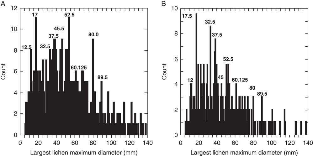
In 1993, we carefully chose the youngest, unaltered moraine of the Kärkerieppe cirque glacier in northern Sweden in a dating test. A simple curving ridge of blocks of a small terminal moraine appeared to record a single recent pulse of deposition. Measurements of the longest axis of the largest Rhizocarpon subgenus Rhizocarpon on 148 blocks were used to date when this simple glacial moraine was created. We expected our measurements to reveal a single peak of lichen sizes. The result was unexpected: lichenometry would suggest that multiple glacier advances created this single glacial moraine.
Figure 1A clearly reveals several episodes of brief intermittent moraine creation, with longer intervening episodes of glacier retreat. The highly significant 71, 81, and 89 mm lichen size peaks date to about AD 1811, 1778, and 1757. A smaller, 58 mm peak marks the end of glacier advances (∼AD 1850), the same age as the end of brief cirque glacier advances in California (Bull, Reference Bull2003a).
Figure 1 Frequency distribution of Rhizocarpon subgenus Rhizocarpon sizes on the blocks of the youngest glacial moraine. Pulsatory moraine deposition: Kärkerieppe, northern Sweden (A) and Cirque Peak, Sierra Nevada, California (B).
The Kärkerieppe study improved our understanding of closely spaced, intermittent glacier advances. Peak width in Figure 1A at 71, 81, and 89 mm describes advances that are brief compared with time spans between maximum glacier advances. Glacier flow continued during these intervening longer spells between maximum advances. The Kärkerieppe glacier was just scooping up and accumulating new chunks of bedrock, detritus for the next brief advance that would add another increment to the terminal moraine.
Standard lichenometry, which was rightly condemned by Osborn et al. (Reference Osborn, McCarthy, LaBrie and Burke2015), would seek and measure the five largest lichens (or the single largest lichen) on a moraine. At Kärkerieppe, they range in size from 125 to 139 mm and are isolated from the lichen size peaks that nicely record the actual times of episodic moraine creation. These five lichen size outliers record nothing more than meaningless old blocks scooped up from hillsides by a rising, advancing glacier and then transported to the terminal moraine. Other tests of “standard lichenometry” in New Zealand and California had similar conclusions.
Measurements of Rhizocarpon subgenus Rhizocarpon on 130 blocks of a Cirque Peak moraine, at an altitude of 3700 m in the Sierra Nevada of California (Fig. 1B), look much like the Figure 1A histogram. Although appearing very young, this moraine is older than the ~1100 yr dating capability of Rhizocarpon subgenus Rhizocarpon.
Sizes for the five largest lichens again are outliers, being isolated from the assemblage of well-defined peaks defined by the other 125 measurements. Suppose one were to date surface exposure using the largest (or five largest) lichen. Not finding the largest (83 mm) lichen would decrease your age estimate of moraine age by ~240 yr. This is why much care is used in searches by those using the largest-lichen method for estimating moraine ages.
However, unlike the Swedish example, these well-defined lichen size peaks may not record multiple advances of the Cirque Peak glacier. For example, earthquakes can increase the supply of rockfall blocks and disrupt an existing moraine. We do not know how many glacier advances created this moraine. Ages for the Figure 1B lichen size peaks nicely match times of rockfall events caused by regional seismic shaking, which is our next topic.
ROCKFALL BLOCK LICHENOMETRY
Lichen sizes precisely date when prehistoric earthquakes caused rocks to tumble down hills. A long record of dated coseismic rockfalls also lets us determine the life spans of slow- and fast-growing genera, and whether the style of crustose lichen growth is exponential or linear.
My large-sample-size style of lichenometry is also used here to date and better understand regional seismic shaking caused by California earthquakes of the past 1000 yr. First, sizes of lichens on rockfall blocks created by AD 1800 to AD 1900 earthquakes are used to estimate precision of dating by comparing lichenometry age estimates with historic earthquake dates. Then, four lichen genera are evaluated for their ability to consistently provide precise, accurate age estimates of regional rockfall events. Usable age range varies with species.
Paleoseismology is the study of the times, frequency, and sizes of prehistoric ruptures and associated seismic shaking. Surface ruptures are revealed in layered sediments of trenches dug across active fault zones. Radiocarbon dating of ruptured stratigraphy continues to be the standard way to date prehistoric earthquakes (Fumal et al., Reference Fumal, Weldon, Biasi, Dawson, Seitz, Frost and Schwartz2002; Biasi and Weldon, Reference Biasi and Weldon2006; Scharer, et al., Reference Scharer, Weldon, Fumal and Biasi2007, Reference Scharer, Biasi, Weldon and Fumal2010; Rockwell et al., Reference Rockwell, Dawson, Ben-Horin and Seitz2015). Dated samples of organic matter created before or after an earthquake constrain when it ruptured layered sediments. However, rockfall-block lichenometry provides better age control because it dates when a seismic-shaking event occurred. Paleoseismologists need lichenometry to (1) accurately date earthquakes and (2) map prehistoric regional seismic shaking.
We also need information about the intensity and extent of seismic shaking caused by the preseismograph large earthquakes on California’s San Andreas and San Jacinto Fault Zones. The AD 1857 and 1800 earthquakes had magnitudes (M w ) of about 7.9 and 7.3, and they ruptured in different directions. Did noteworthy seismic shaking occur 500 km north in the lofty Sierra Nevada for one or both earthquakes? Fault-zone geometry and distance from an earthquake epicenter both affect the relative importance of compression and shear types of seismic waves in causing rockfalls and larger landslides in the Sierra Nevada.
The Seismological Society of Japan funded John Milne’s invention of the seismograph in AD 1880. Seismographs provide essential details about initiation of a rupture in the earth’s crust, propagation and transmission of several types of seismic waves, and shaking intensity. Before seismometers, human recollections were used to map approximate seismic-shaking intensity. However, personal assessments of seismic shaking vary greatly and are not available for earthquakes before European settlement of America. Truly quantitative appraisals of seismic-shaking events that occurred before AD 1880—designated here as prehistoric earthquakes—were not possible prior to lichenometry studies such as this one. Using lichen sizes to date coseismic rockfalls and map regional patterns of rockfall-event abundance provides detailed insights about the intensity and extent of prehistoric seismic-shaking events.
Useful lichenometry seeks safety in ample measurements. Digital calipers are used to measure (to 0.01 mm) the long axis of the largest lichen on many blocks deposited by glacial, fluvial, or landslide processes. The largest lichens on outcrop joint faces are also measured where they are the sources of landslide and moraine blocks.
The scope of this evaluation of lichenometry to date rocks that tumble downhill during California’s earthquakes is broad. Four genera of crustose lichens, growing in diverse landscape and climatic settings, were measured to better understand lichen growth in this 600-km-long study region (Bull, Reference Bull2014). Lichen growth rates, and high dating precision, can be confirmed here. Using rockfall events dated to known days of historic earthquakes makes it easy to address a good point raised by Osborn et al. (Reference Osborn, McCarthy, LaBrie and Burke2015, p. 5)—“one cannot be sure that the largest lichen is an early colonizer.” Narrow lichen size histogram peaks (Figs. 3–5) date to within 5 yr of known earthquake dates. A Cirque Peak study of how earthquakes affected adjacent moraine and talus deposits clarifies crustose lichen life spans. Then, regional trends in rockfall event sizes are used to map consequences of seismic shaking caused by San Andreas Fault System earthquakes that occurred before invention of the seismograph.
Dating the largest lichen on many rockfall blocks shows that hillslope talus in California accumulates intermittently—at the times of earthquakes (Bull et al., Reference Bull, King, Kong, Moutoux and Phillips1994; Bull, Reference Bull1996a, Reference Bull2003a, Reference Bull2007, Reference Bull2013, Reference Bull2014). The same is true for New Zealand (Bull, Reference Bull1996b, Reference Bull2000, Reference Bull2003b, Reference Bull2010; Bull and Brandon, Reference Bull and Brandon1998). Each strong seismic-shaking event detaches more blocks from crumbly cliffs and may shift blocks residing in steep hillslope talus to new positions. New crustose lichens colonize these freshly exposed substrates.
The longest axis of the largest lichen on each rockfall block was assigned a numerical quality rating of 1 to 4 when considering thallus candidates for measurement. Elliptical shapes and abrupt, smooth edges contribute to accurate size measurements. The ratings were as follows: quality 1, beautiful but uncommon; quality 2, very nice but usually less than a third of the measurements; quality 3, somewhat ragged edges, but longest axis measuring points appear reliable, being on smoother portions of the thallus; and quality 4, doubtful quality and so not measured. Two categories (accept or reject) could be sufficient, but using four thallus quality classes let me assess if using quality 3 thalli lowers dating precision and accuracy (it does not).
Lichen sizes on talus blocks record a prehistoric earthquake when the same histogram peak occurs throughout a region. Decreased intensity of seismic shaking with distance away from California active fault zones (Fig. 2) is recorded by fewer rockfalls. Spatial variations in lichen peak size can be used to map the consequences of regional seismic-shaking intensity caused by a prehistoric earthquake.
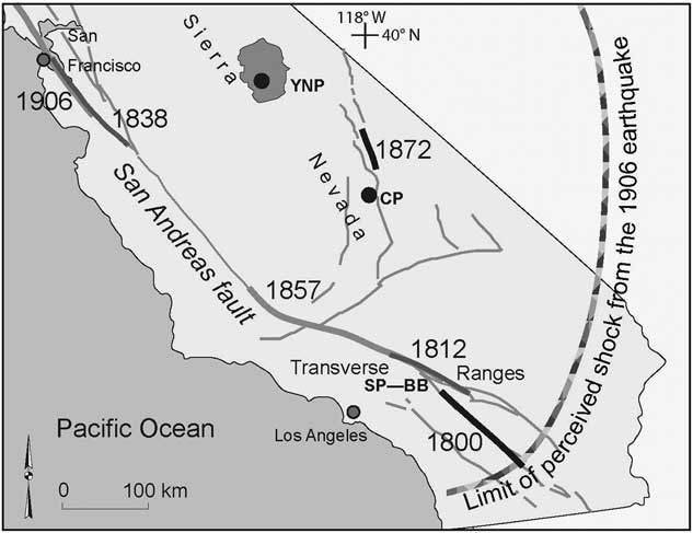
Figure 2 Active fault zones and dates of recent California earthquakes. YNP; Yosemite National Park and CP; Cirque Peak are in the Sierra Nevada. SP; Strawberry Peak and BB; Big Block lichenometry sites are in the San Gabriel Mountains of southern California.
Synseismic rockfall events were dated with four common crustose lichen genera: Rhizocarpon subgenus Rhizocarpon, Acarospora chlorophana, Lecanora sierrae, and Lecidea atrobrunnea. Lichen growth rates were calibrated at sites younger than an AD 1739 tree-ring- dated landslide, whose time of substrate exposure is known to the day or year. Rates of growth range from 9.5 to 23.1 mm per century, and each genus grows at its constant rate in this 600-km- long region. Calibration-site measurements define regressions of mean lichen size in millimeters (D) and calendric age in years (t) as follows: (1) Acarospora chlorophana, D=229.48−0.114 t; (2) Lecanora sierrae, D=380.46−0.189 t; (3) Lecidea atrobrunnea, D=465.00−0.231 t; and (4) Rhizocarpon subgenus Rhizocarpon, D=191.81−0.095 t.
Site selection is important. Preferred earthquake-study sites have planar talus, are below ridgecrest outcrops too small to generate snow avalanches, and are away from the roots of toppled trees. Cone-shaped talus deposits at the mouths of funnel-shaped source areas were avoided because some of the blocks may have been deposited by snow avalanches, water floods, or debris flows. Largest lichen sizes were measured on ~50 to 500 talus blocks at 77 sites and on the joint faces of outcrops from which the blocks were derived.
The fast-growing genus Lecanora was preferred for dating recent rockfall events, and Acarospora chlorophana for dating old rockfalls. Both are common and have elliptical thalli with nicely defined margins. Evaluating the dating accuracy requires a comparison of lichenometry age estimates with times of historical earthquakes and tree-ring-dated prehistoric seismic-shaking events.
Lichenologists interested in growth, competition, and mortality of crustose lichens (Farrar, Reference Farrar1974; Bradwell and Armstrong, Reference Bradwell and Armstrong2007) wonder how long original colonizing thalli live. Loso and Doak (Reference Loso and Doak2005, p. 26) concluded that “the cumulative probability of any single thallus living beyond 200 years is consequently quite low (* * * R. geographicum <1%)” (pp. 226). This suggests that we should avoid using lichens to date surfaces older than ~150 yr if the first colonizers of slow-growing genera are soon crowded out. Of course, lichen thalli may live long after the longest axis measuring points have been crowded out by competing thalli. Their coastal Alaska study area is extremely humid and cool. Similar lichenometry drawbacks were not present in my semiarid to subhumid study region.
Field work was done from 1991 to 2013, but using peaks in lichen abundance to map regional seismic shaking requires that all measurements be normalized to the same calendar year. For example, measurements of Lecanora sierrae made in 2011 were normalized to 2013 by adding 0.38 mm (0.19 mm for each year).
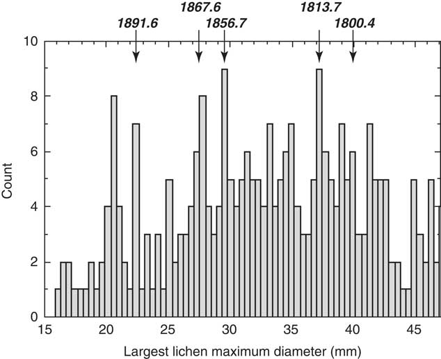
Lichen sizes of the genus Lecidea measured in 2002 at Roaring River (Fig. 3) illustrate the normalization procedure for converting any lichen size data set to 2013 Lecanora sizes. Lecidea sizes were divided by 0.818, and 3.59 mm was added to each measurement to normalize the data to equivalent 2013 Lecanora sizes. The accuracy of dating for the three southern California earthquakes noted in the Figure 3 histogram is a good check of this procedure—its mean dating error is only±1 yr. The pronounced 35 mm peak and other lichen size peaks were not studied here. Being expressed at widely dispersed sites, however, these other peaks also record seismic-shaking events.
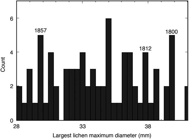
Figure 3 Modeled Lecanora sizes on coseismic rockfall events at Roaring River in the Sierra Nevada record three southern California earthquakes in AD 1800, 1812, and 1857. Class interval is 0.4 mm.
Good botanical questions regarding variable growth rates (Mathews and Trenbirth, Reference Matthews and Trenbirth2011) need answers. Lichen growth changes to a consistent long-term style of growth after fruiting structures emerge on young thalli. Initial growth typically is quite rapid, but how long is this “great-growth phase”? And, is the style of long-term lichen growth exponential or linear?
Data sets for two lichen genera can be merged only if both have linear styles of growth. Two Big Block site (in the San Gabriel Mountains) data sets were merged in order to determine whether the long-term lichen growth style is arithmetic or logarithmic. Lecanora size measurements comprise 57% of Figure 4 data; and the faster-growing Lecidea, 43%. Lecidea measurements were converted to Lecanora sizes by multiplying by 0.88.

Figure 4 Modeled Lecanora size distribution at Big Block site, San Gabriel Mountains. Dates for lichen size peaks at top are compared with historic earthquake dates in Table 1.
The Figure 4 lichen size peaks nicely match the times of historic earthquakes (Table 1), consistent with both genera having an arithmetic style of long-term growth. Using the two fastest-growing lichen genera can then improve dating accuracy. Acarospora chlorophana and Rhizocarpon subgenus Rhizocarpon also have a linear style of growth.
Table 1 Dating accuracy of lichenometry, calculated by comparing rockfall-event lichenometry ages at the Big Block site with historical earthquake dates.

Precision and accuracy of lichenometry is surpassed only by dendrochronology and historic records. A dating accuracy of ~±2 yr is the same as in New Zealand (Bull, Reference Bull2003b) and at another California site (Bull, Reference Bull2014, table 1 and fig. 8). Older lichenometry age estimates have the same ~±2 yr accuracy when tested by tree-ring dating (Bull and Brandon, Reference Bull and Brandon1998; Bull, Reference Bull2007).
Table 1 dating errors increase abruptly for the youngest modeled Lecanora lichen peak (21.00 mm). It records intensity of nearby seismic shaking. So for ages this young, either Lecanora or Lecidea thalli (or both) do not have a linear style of growth. Consistent linear growth begins after a thallus reaches a peak size of 21 mm.
OLDER SYNSEISMIC ROCKFALLS
Lichenometry is useful for comparing intensities of prehistoric seismic-shaking events in remote areas. Cirque Peak in the granitic Sierra Nevada of California is at an altitude of 3700 m. The lichen size distribution for surficial blocks on a fragile glacial moraine has pronounced peaks. Each peak records a disturbance strong enough to create many new rock substrates for Rhizocarpon subgenus Rhizocarpon (Fig. 1B) and Acarospora chlorophana (Fig. 5A) to colonize.

Figure 5 Acarospora chlorophana size distributions at Cirque Peak in the Sierra Nevada. (A) Young glacial moraine; 0.5 mm class interval; n=351. (B) Hillslope talus; 0.5 mm class interval; n=138.
These lichen size peaks occur at sites throughout much of the study region. Thus, they record earthquakes on nearby and distant fault zones, not glacial processes. Three histogram spikes (Fig. 5A) stand out. The young 17.0 mm peak records the nearby M w ~7.8 Lone Pine earthquake of AD 1872 (only 30 km away). The 52.5 mm peak is prominent at southern California lichenometry sites. It records a San Andreas Fault earthquake radiocarbon dated as ~AD 1531–1569 (Biasi and Weldon, Reference Biasi and Weldon2006). An 80 mm Acarospora chlorophana peak at Icehouse Canyon in the San Gabriel Mountains is just as pronounced as here.
Measuring lichen sizes on a nearby Cirque Peak talus slope just examines the rockfall record, thus avoiding any possibility of dating disturbances caused by shifting glacial ice. Event by event, the regional seismic-shaking events suggested in Figure 5A are faithfully repeated in the Figure 5B rockfall record. Comparing the moraine disturbance and talus lichen size peaks tests the consistency of lichenometry for dating earthquakes when using Acarospora chlorophana. Dating replication in this test is±2 yr.
Cirque Peak and Icehouse Canyon Acarospora chlorophana record seismic events much older than the 200 yr maximum lichen life span suggested by Loso and Doak (Reference Loso and Doak2005). The 89.5 mm lichen size peak is common and dates to AD 1190±5 yr.
REGIONAL PATTERNS OF PREHISTORIC SEISMIC SHAKING
Southern California earthquakes cause significant seismic shaking much farther north into the Sierra Nevada than Cirque Peak (Fig. 1B). Rockfalls near Tahoe and Yosemite (Fig. 6) record seismic shaking generated by southern California earthquakes.
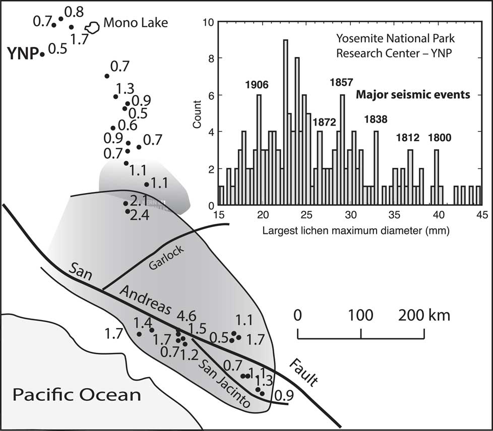
Figure 6 Regional changes in AD 1857/AD 1800 ratio of seismic shaking based on synseismic rockfall abundances.
The dominance of coseismic sources of rockfall blocks in Sierra Nevada talus poses interesting questions. Did the relative styles and strengths of seismic shaking in AD 1800 and 1857 remain constant or change toward the north? Which styles of seismic wave transmission were most effective in disrupting jointed batholithic rocks?
Intense regional preinstrumental seismic shaking is studied here for major earthquakes on two fault zones that rupture every 100 to 200 yr. The San Andreas Fault System accommodates ~60% of the right-lateral displacement between the Pacific and North American plates (Crowell, Reference Crowell1979, Reference Crowell1986). The Fort Tejon earthquake of January 9, 1857, had an M w of ~7.9 (Sieh, Reference Sieh1978; Scharer, et al., Reference Scharer, Biasi, Weldon and Fumal2010). It ruptured 360 km of the Mojave segment of the San Andreas Fault but propagated to the southeast, away from the Sierra Nevada. The M w ~7.3 earthquake of November 22, 1800, ruptured the southeast-to-northwest–trending Clark strand of San Jacinto Fault (Rockwell et al., Reference Rockwell, Dawson, Ben-Horin and Seitz2015), which has a northerly orientation favorable for sending seismic energy toward the Sierra Nevada.
Crumbly cliffs of jointed rocks of the Sierra Nevada batholith may fracture or collapse when pulses or waves of seismic energy arrive. Lichens on coseismic rockfall blocks record when episodes of disruptive seismic energy arrived from the south. Rockfall abundance ratios for the AD 1800 and AD 1857 earthquakes are used here to (1) describe how regional seismic-shaking intensity changed toward the north and (2) compare the potential of four types of greatly different seismic waves to rupture jointed plutonic rocks.
A seismic-shaking index ratio is used here to compare the AD 1800 and 1857 events. Overall density of measurements in a histogram of lichen sizes typically rises and then declines. So we need to account for the relative importance of a narrow peak in the overall distribution. Here, earthquake-induced rockfall abundance is proportional to the total number of measurements in the 4 mm on both sides of a lichen size peak.
The Roaring River lichenometry site in the South Fork of the Kings River is used in the Figure 3 example. It is about 220 and 360 km to estimated epicenters of the AD 1857 and 1800 earthquakes on the San Andreas and San Jacinto Fault Zones, respectively. The AD 1857 peak has 13% of measurements relative to the adjacent 54 measurements. The AD 1800 peak is more significant because it has 23% of 31 adjacent measurements. For this particular site, the AD 1857/AD 1800 seismic-shaking index ratio is 13/23, or 0.6.
Ratios of AD 1857/1800 seismic-shaking intensity (Fig. 6) are largest close to the 1857 surface rupture. Sites closer to the northern part of the San Jacinto Fault show minimal change in ratio, indicating a consistently stronger earthquake in AD 1857, and because the AD 1800 surface rupture was farther south. The Mojave Desert is a lichen-free gap between the San Andreas and Garlock Faults. Nevertheless, dominant AD 1857 seismic-shaking intensity persisted into the southern Sierra Nevada where crutose lichens flourish.
The spatial pattern of seismic shaking from these two earthquakes changes, south-to-north: from dominant AD 1857 shaking, to equal shaking, and then reversal. At the more northerly sites, the AD 1800 San Jacinto Fault earthquake caused more rockfalls than the AD 1857 San Andreas Fault earthquake, despite the San Jacinto Fault surface rupture being shorter and more distant. This seemingly anomalous pattern of rockfall abundance might be explained by (1) the northwest orientation of the San Jacinto Fault and/or (2) how the relative importance of different types of seismic waves changes with distance from either the AD 1800 or AD 1857 earthquake surface ruptures.
Four types of seismic waves (Bullen and Bolt, Reference Bullen and Bolt1985; Stein and Wysession, Reference Stein and Wysession2009) have different impact intensities and seismic-shaking styles. Relative effectiveness in creating landslides by compression and shear waves changes with distance from their seismic source. Seismic waves (Richter, Reference Richter1958) generated in southern California arrive in the Sierra Nevada as a sequence. P waves move at a fast 6 km/s, and a strong sudden jolt is created by this compression-style wave. Then slower S waves roll through at ~3–4 km/s and are well known for their capacity to destroy masonry buildings. Surface waves travel on Earth’s surface and are the last to arrive. Rayleigh surface waves have an elliptical motion, with vertical and horizontal components of motion in the direction of wave propagation. Love waves oscillate parallel to the surface and perpendicular to wave propagation direction.
The ability to maintain destructive capacity with increasing distance is strongest for Love and Rayleigh waves, good for P waves, and least for S waves. Both surface wave types are credible candidates for causing strong AD 1800 Sierra Nevada seismic shaking far to the north. In contrast, the S-wave style of seismic shaking from the AD 1857 earthquake appears strong enough to be the dominant cause of southernmost Sierra Nevada rockfalls.
The San Jacinto Fault, not the San Andreas Fault, is best oriented to direct destructive P and surface waves toward the Sierra Nevada. If the block on the west side of the fault moved northward in AD 1800, the result would be a relatively large AD 1800 pulse of rockfalls, as noted farther north at many Figure 6 locations.
Even at 500 km north, in Yosemite National Park (YNP in Fig. 6), the AD 1800 event is prominent and nicely isolated. No wonder that earthquake-induced rockfalls are considered hazardous to national park visitors (Stock and Collins, Reference Stock and Collins2014). Yosemite is opposite the San Francisco Bay area, so the AD 1836 and AD 1906 earthquakes on the northern part of the San Andreas Fault System also are recorded. A similar increase in the ability of destructive seismic waves to create distant rockfalls was observed in New Zealand by mapping the ratio of rockfall blocks generated by large earthquakes that occurred in AD 1848 and AD 1855 (Bull, Reference Bull2010, fig. 2.8).
S and surface earthquake waves open and close fissures and exfoliation joints in massive granitic outcrops. Small blocks can drop into open vertical joints, where they then can act as a wedge during compression phases during an ongoing or subsequent earthquake. This seismic ratchet process (Bull, Reference Bull2007, p. 266; 2014, fig. 11) causes landslides ranging in size from rockfalls to rock avalanches.
CONCLUSIONS
Successful surface exposure dating with lichens varies greatly with choice of field measurement procedure. I agree with Osborn et al. (Reference Osborn, McCarthy, LaBrie and Burke2015) that measuring only the largest lichen, or the five largest lichens, to date a glacial moraine should be abandoned. The largest five lichens typically are far removed from the usable peak(s) of a lichen size distribution. Typically, these statistical outliers began growing before their blocks were deposited in a glacial moraine.
When compared with California’s historic earthquake record, my procedure provides consistently accurate dates for coseismic rockfall events stored in talus slopes (Bull, Reference Bull1996b, Reference Bull2000, Reference Bull2003b, Reference Bull2007, Reference Bull2010, Reference Bull2013, Reference Bull2014). This approach has been erroneously dismissed by Osborn et al. (Reference Osborn, McCarthy, LaBrie and Burke2015).
Measuring the longest axis of the largest thallus on many blocks on recently created moraines in Sweden and California reveals peaks in lichen size distributions. In Sweden, they nicely describe episodic deposition, even for a terminal moraine that looks like it was created by a single glacier advance. Precise, accurate dates (±5 yr or better) of these lichen size peaks describe closely spaced episodes of moraine formation, improving our understanding of how montane glaciers create moraines. A similar appearing cluster of lichen size peaks for a latest Pleistocene moraine on Cirque Peak in California records disturbances by earthquakes.
The inherently unstable nature of young glacial moraines makes them an underutilized resource for studying regional seismic-shaking events of the past thousand years. Areal variation in magnitudes of lichen size peaks can be used to describe prehistoric regional seismic shaking. Much of the world—the Pacific Ring of Fire and the Mediterranean–Near East—is ideal for lichenometry studies of regional seismic shaking of unstable mountains within 300 km of active fault zones. However, one needs to avoid surface exposure dating with crustose lichens in extremely wet or dry climatic settings because of unsuitable growth rates and/or absence of crustose lichens.
Earthquakes generate seismic shaking that disrupts distant cliffy outcrops, causing regionally synchronous landslides in California’s Sierra Nevada and Transverse Ranges. Episodic additions of rockfall blocks to talus slopes create many new surfaces for crustose lichens to colonize. Dating of younger lichens that colonized rockfall blocks generated by AD 1800 to 1900 AD earthquakes precisely defines (±2 yr) lichen growth as linear for four genera of crustose lichens, after a brief adolescence of rapid growth.
The longest axis measurements of the largest lichen on surfaces of known age in California, New Zealand, and Sweden reveal linear styles of lichen growth and growth rates that do not change with the passage of time. Growth rates, in mm/century, for Rhizocarpon subgenus Rhizocarpon are 9.5 for California, 15.2 for New Zealand, and 32.3 for Sweden. These uniform growth styles are different than the areal variation in growth rates of much different lichen species described in much colder Antarctica by Sancho et al. (Reference Sancho, Green and Pintado2007), where regional variations in climate are extreme compared with my three study regions.
Dated talus accretion events nicely assess lichen life spans. A single thallus of fast-growing Lecanora may persist for only 400 yr before encroaching younger lichens impinge on the longest-axis measuring points. Some slow-growing Acarospora chlorophana and Rhizocarpon subgenus Rhizocarpon have longest-axis measuring points that persist for 1100 yr. Lichen size peaks with ages of 1800 yr are rare.
Dated synseismic rockfall events provide insights into the magnitude, extent, and styles of seismic shaking caused by San Andreas Fault System earthquakes. Earthquake S waves in AD 1857 were the most likely cause of many rockfalls from jointed plutonic outcrops in the southernmost Sierra Nevada. Then, with increasing distance to the north, the Love and Rayleigh styles of surface waves created by the AD 1800 earthquake on a north-trending surface rupture may have become more effective than the AD 1857 southeast-trending surface rupture in creating landslides.
This geomorphic approach to paleoseismology should be used in many earthquake-prone mountainous regions of the world. Having known times of creation of new rock surfaces by recent and old major historical earthquakes will help define crustose lichen growth rates in Chile, Turkey, and Japan. Another study should make a map of Washington, British Columbia, and Oregon depicting the regional extent of severe seismic shaking caused by the major January 26, 1700, Cascadia subduction-zone earthquake.
ACKNOWLEDGMENTS
I appreciate financial support for this work from the Geophysics Program, U.S. National Science Foundation, the Royal Swedish Academy of Sciences, and the Swedish Environmental Protection Board. Many field assistants achieved uniformly high levels of data collection as shown by the clarity of seismic-shaking events revealed in plots of lichen size distributions.