


INTRODUCTION: CEMETERIES IN NEED OF CONTEXT
Sardinia presents a particularly rich and diversified tradition of prehistoric monumentality, from Late Neolithic tombe a circolo to Copper Age statue-menhirs and to Nuragic stone towers and megalithic ‘giant tombs’ in the Middle Bronze Age and Iron Age (Lilliu Reference Lilliu2003; Contu Reference Contu2006). But one type of burial architecture was used across all these periods: hypogea or rock-cut tombs (Contu Reference Contu2000). The most ancient ones, such as at Cuccuru S’Arriu in Cabras (Santoni Reference Santoni2000), date from around 4500 cal bc (Bonu Ighinu culture, 4900–4400 cal. bc: Middle Neolithic) and have a distinctive single, round, oven-shaped (a forno) chamber with a shaft access (pozzetto), which was used for a limited number of primary inhumation burials. In the Late and Final Neolithic (San Ciriaco and Ozieri cultures, 4400–3500 cal bc), rock-cut tombs adopted a different architectural style, with a horizontal layout comprising a succession of squared chambers, which were used for collective (often secondary) burials (Melis Reference Melis2012). These are locally known as domus de janas (‘fairy houses’) and are by far the most numerous rock-cut tomb type in Sardinia, with about 3500 examples estimated across the island (Tanda Reference Tanda and Lugliè2009). In addition to their complex plan, several have wall carvings and paintings that imitate architectural elements of presumably house interiors: pillars, roof beams, door frames, hearths, etc. Other decorations depict stylised cattle heads (bucrania) (Tanda Reference Tanda2015; Robin Reference Robin2016; Reference Robin2017). Finally, these tombs are generally found in clusters (or ‘cemeteries’) in the landscape.
Domus de janas rock-cut tombs have attracted attention since the start of archaeological investigations in Sardinia in the early 20th century. Studies have focused on cataloguing and surveys (eg, Taramelli Reference Taramelli1904a; Reference Taramelli1919a; Reference Taramelli1919b; Chelo Reference Chelo1955), with particular interest in internal plans and wall decorations for typological comparisons and classifications (eg, Santoni Reference Santoni1976; Tanda Reference Tanda1985). Excavations have also been carried out in several tombs (eg, Taramelli Reference Taramelli1904b; Contu Reference Contu1964; Melis Reference Melis2010; Salis et al. Reference Salis, Farci, Sarigu and Pusceddu2015; Tanda Reference Tanda2015, 352–3), which provided dates and permitted a better understanding of their multiple funerary uses. Research so far, therefore, has focused on the tombs themselves, and less attention has been given to the general environment of the cemeteries.
First, the physical environment of the cemeteries has been surprisingly overlooked. The different morphologies or rocky outcrops into which individual tombs were created, eg, from flat outcropping surfaces to boulder faces, rocky slopes or cliffs, have been highlighted (Tanda Reference Tanda2015, 58–60), however, the wider landscape setting of entire cemeteries, and their relationship with the specificities of the local terrain, have rarely been looked at beyond simple map descriptions. Rock-cut tombs are underground monuments. Unlike megalithic tombs and tumuli they are not superimposed on a landscape but dug into it. They are entirely integrated into natural features of the landscape. How was the location of the tombs decided during the Neolithic? Was their implantation influenced by specific attributes of the landscape, such as the geology, altitude, aspect of bedrock faces, river valleys, etc? How were multiple tombs organised together within the macro-topography of cemeteries? Did these reflect cosmological perceptions of (and ritual interactions with) the landscape?
Secondly, the social environment of the cemeteries and, in particular, the settlements associated with them, is often absent from archaeological accounts of domus de janas (Erbì Reference Erbì and Tanda2015). This is mainly due to the relative scarcity of data on Neolithic and Chalcolithic settlements in Sardinia. Approximately 80 sites are known, which contrasts with the c. 3500 recorded domus de janas. These include sunken ‘hut’ floors (fondi di capanna) and stone-built structures. Most of them are located in the flatter plains in the centre-west and south of the island, where rock-cut tombs are scarce, and were surveyed or excavated as part of rescue archaeology projects (see Webster & Webster Reference Webster and Webster2017 for a recent overview). The most famous of them is the stone settlement of Serra Linta in Sedilo (province of Oristano), whose large apsidal structures were surveyed before their submersion under the water of the artificial Omodeo river basin. The site is 1800 m downhill from the cemetery of Ispiluncas, whose apsidal rock-cut tombs are often described as imitations of the Serra Linta houses (Tanda & Depalmas Reference Tanda, Depalmas and Campus1997; Tanda Reference Tanda1998). Based on this model, it is often assumed that Late Neolithic settlements in Sardinia were located at the bottom of agricultural valleys while the tombs were on higher ground above them (Derudas Reference Derudas2000, 16–17). However, this model has rarely been tested or challenged with further research on tomb–settlement landscape relationships elsewhere in Sardinia. In Usini (north-west Sardinia), surface scatters of flints and pottery were found on the plateau immediately above the cemeteries of S’Elighe Entosu and Santa Caterina, indicating that settlements were actually on higher ground and closer to the tombs than at Sedilo (D’Anna et al. Reference D’Anna, Guendon and Soula2010; see also Soula Reference Soula, Robin, D’Anna, Schmitt and Bailly2016).
The absence of settlement data in the proximity of major cemeteries is mainly due to a lack of research programmes dedicated to this issue. Systematic surface surveys around tomb clusters need to be more developed. The interest is not to simply plot residential locations around tomb clusters but to investigate the spatial relationships between the cemeteries and their contemporary settlements and, therefore, to address elementary questions such as: how far did Neolithic communities live from their communal cemeteries? Was each cemetery used by a single, large village, or rather by a catchment of small, dispersed settlements?
Villages of the living and ‘villages of the dead’ can interact spatially and visually in different ways: researching this offers interesting opportunities to better understand the social status of the dead, the nature of the relationship between the two communities during the Neolithic, and the role of the landscape in framing this relationship (Parker Pearson Reference Parker Pearson1999, 124–5). Did Neolithic villagers avoid interactions with the dead, placing them in remote hidden locations in the landscape? Or were the dead involved in the daily routine of the farming communities, requiring regular contact and communication?
THE OSSI PROJECT
In order to address these questions, a project was initiated in 2017 in Ossi, a municipality located in north-west Sardinia where rock-cut tombs are found in significant densities. The project focuses on the hydrographic basin of the Riu Briai, a small seasonal stream tributary of the Riu Mannu, which is one of the main rivers of north-west Sardinia (Fig. 1). Geologically, the area is composed of Miocene sedimentary rocks, as a sequence of alternating beds of compact marine biodetrital limestone (creating hilltop plateaux, escarpments, and intermediary levels) and marly sandstone (more affected by erosion and creating gentler slopes) (Mazzei & Oggiano Reference Mazzei and Oggiano1990). The area was selected because of its interesting concentration of well-defined cemeteries within a rather small area of 3 × 3 km. Four main clusters of rock-cut tombs are distributed on the upper marginal slopes of the basin, around the agricultural terrace of Sas Renas-Bores: Mesu ‘e Montes (18 tombs: Derudas Reference Derudas2004a), S’Adde ‘e Asile (12 tombs: Derudas Reference Derudas2004b), S’Isterridolzu (nine tombs: Merella Reference Merella2009) in Ossi, and Monte Sa Jana in Florinas (three tombs: P. Melis Reference Melis2000a).
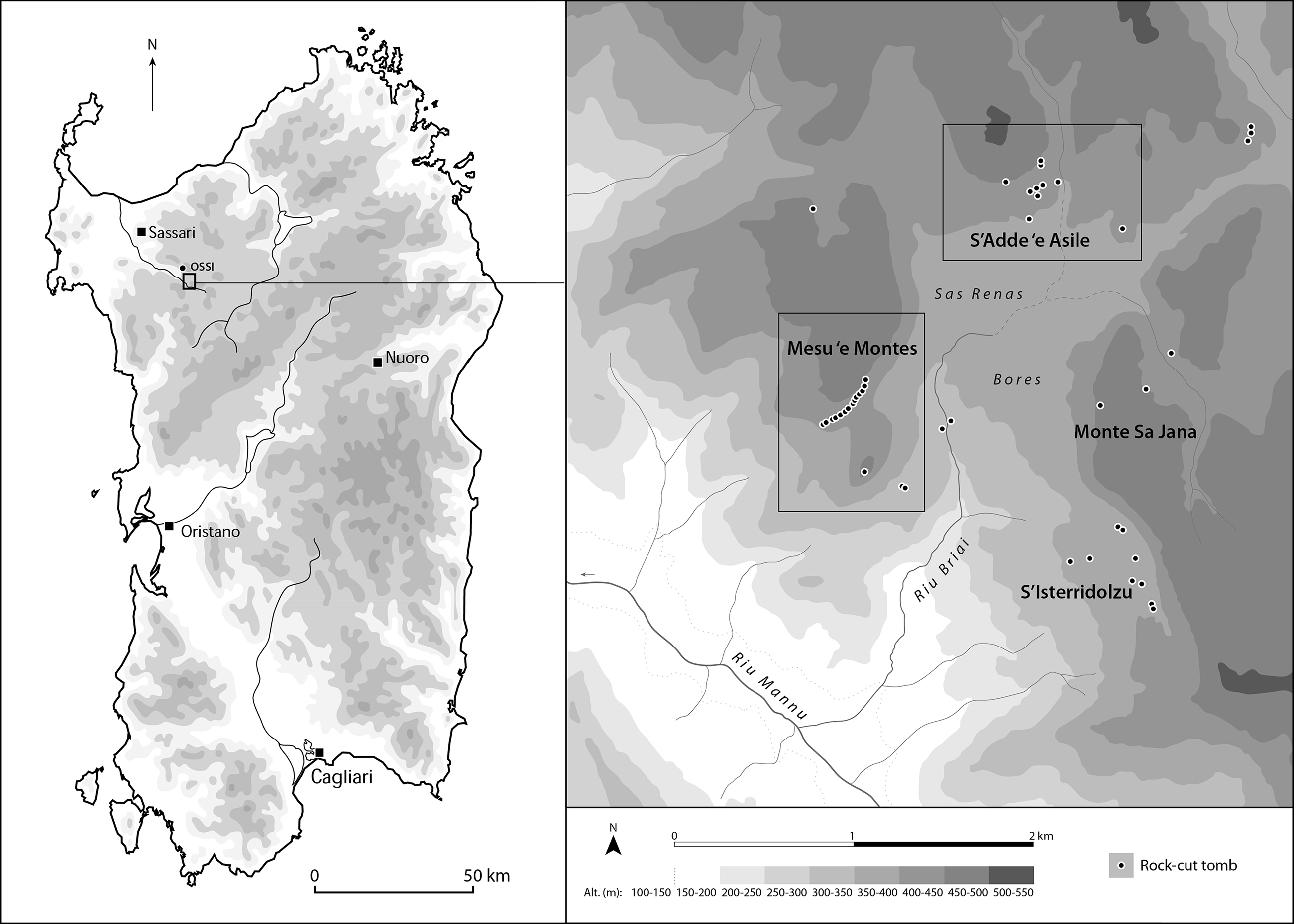
Fig. 1. Location of the rock-cut tomb cemeteries of Mesu ‘e Montes and S’Adde ‘e Asile in Sardinia (left) and in the hydrographic basin of the Riu Briai in Ossi (right)
The project has two main objectives. The first is to create a detailed and comprehensive digital survey of the cemeteries, which includes not only the tombs and their decorated interiors but also their landscape setting. To do so, we use 3D photogrammetry techniques at various scales. Drone photos are used to record the terrain within and around the cemeteries (eg, 4500 photos were needed for the 58 ha cemetery area of Mesu ‘e Montes), while hand-held cameras are used to record the underground interior and the outside surrounding of each tomb (typically 600–2000 photos per tomb, depending on size, architectural, and decoration variations). Photos are processed in Agisoft Photoscan Pro for 3D reconstructions. Ground targets with differential GPS coordinates are distributed across the cemeteries and around each tomb, to georeference the various 3D models. This permits the integration of the 3D data into a GIS environment for further spatial analyses. Such an integrated recording of the cemeteries, that combines a detailed survey of tomb’s architecture and the overall landscape setting, makes it possible to investigate the relationship between the tomb locations and natural features such as topography or aspect, as well as spatial correlations between the tomb architectural design and the surrounding landscape.
The second objective is to identify the location of settlements associated with the cemeteries. This is done by intensive fieldwalking in land parcels surrounding the burial sites, with accurate mapping of surface finds such as lithic flakes and tools, pottery sherds, and structural evidence, using a differential GPS rover. Although the Riu Briai basin is rich in burial monuments, only limited evidence of lithic spreads has been noted so far (Derudas Reference Derudas2000, 16–17, 126; Merella Reference Merella2013, 15, 105–6). The aim of the d-GPS mapping is to produce detailed maps of concentrations of surface evidence (eg, GIS heat maps), to locate possible residential areas and to evaluate quantitatively their spatial extension, density, and archaeological preservation in relation to the physical terrain. Diagnostic artefacts are also collected for specialist analysis and chrono-cultural evaluation.
The present paper concentrates on the results of the 2017 and 2018 fieldwork seasons, which focused on the two largest cemeteries of the area: Mesu ‘e Montes and S’Adde ‘e Asile (Fig. 1).
CASE-STUDY 1: MESU ‘E MONTES
The rock-cut tombs
Mesu ‘e Montes is one of the largest and most famous rock-cut tomb cemeteries in Sardinia, with 18 tombs including several decorated with carvings, incisions, and paintings (Tanda Reference Tanda1985; Reference Tanda2015). Most of the tombs were emptied and left exposed ab antiquo, and several were recut and reused as pastoral shelters up to recent times. The site was first reported archaeologically in 1968 (Contu Reference Contu1969). Tomb 2, whose content had partially survived, was subsequently excavated by the Soprintendenza archeologica di Sassari. Based on the material culture recovered during the excavation, the tomb’s phases of use spanned from the early Chalcolithic to the Early Bronze Age (Demartis & Canalis Reference Demartis and Canalis1989). The other tombs were examined by Ossi archaeologist Pina Derudas as part of a large-scale programme of archaeological survey of the entire municipality (Derudas Reference Derudas2000; Reference Derudas2004a).
The tombs are located in a dramatic landscape. Mesu ‘e Montes means ‘in between the hills’ in Sardinian: the toponym corresponds to a small depression valley separating Monte Mamas (to the north-west) from Monte Mannu (to the south-east), which are two limestone plateaux dominating the area at 462 m and 490 m amsl (Fig. 2). The rock-cut tombs of Mesu ‘e Montes are in fact all located on the south-east escarpment of the limestone plateau of Monte Mamas. This exposed rock consists of an almost uninterrupted 400 m long and 10–15 m high vertical face of compact limestone, well suited for the cutting of underground burial chambers (Fig. 3). This morphology explains the arrangement of the 18 tombs, excavated side-by-side on the same horizontal level, and grouped together in two main clusters in the north and in the south of the escarpment.

Fig. 2. Aerial view of Mesu ‘e Montes from the north-east. Rock-cut tombs are located on the escarpment highlighted on the right of the image (photo: Guillaume Robin)

Fig. 3. Elevation of the southern escarpment at Mesu ‘e Montes, with the entrances of Tombs 1–15 (photogrammetry & CAD: Guillaume Robin)
The majority of the tombs are poorly preserved due to natural erosion and recent pastoral reuse but many still have remarkable architectural features and decorations. Tomb 1, for instance, has a typical domus de janas layout (see Robin Reference Robin2016), with an antechamber leading to a large central chamber (Fig. 4). The large chamber gives access to smaller, raised cells (presumably used for body depositions), and was likely the focus for ritual activities associated with burials. Indeed, the chamber has a concentration of carved symbolic apparatuses, such as a central cup on the floor, schematic cattle bucranium reliefs on the side walls (Figs 4 & 5), and a false doorway at the centre of the back wall (Fig. 6). Tomb 2 has a similar plan but includes two detached pillars symbolically supporting the roof beams incised on the ceiling of the main chamber, as well as a large number of carved motifs such as cattle horns, triangles, spirals, zigzags, a symbolic doorway, and a sculpted hearth (Fig. 7; Demartis & Canalis Reference Demartis and Canalis1989). Other carved motifs are visible, although in poorer state of preservation, in Tombs 6, 9, and 16 (Derudas Reference Derudas2004a). Tomb 13 has a large, D-shaped (or apsidal) antechamber with radial beams carved on the ceiling (Fig. 8).

Fig. 4. Mesu ‘e Montes Tomb 1: Plan and longitudinal cross-sections (photogrammetry & CAD: Guillaume Robin)

Fig. 5. Mesu ‘e Montes Tomb 1: View of the main chamber, with wall reliefs (photo: Nicola Castangia)

Fig. 6. Mesu ‘e Montes Tomb 1: Cross-sections (photogrammetry & CAD: Guillaume Robin)
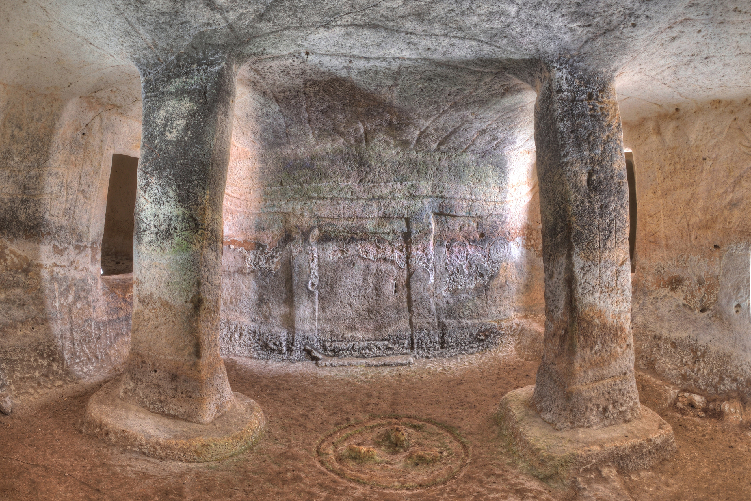
Fig. 7. Mesu ‘e Montes Tomb 2: View of the main chamber, with walls and pillars covered in engravings. Note the symbolic doorway on the back wall and the circular ‘hearth’ carved on the floor (photo: Nicola Castangia)
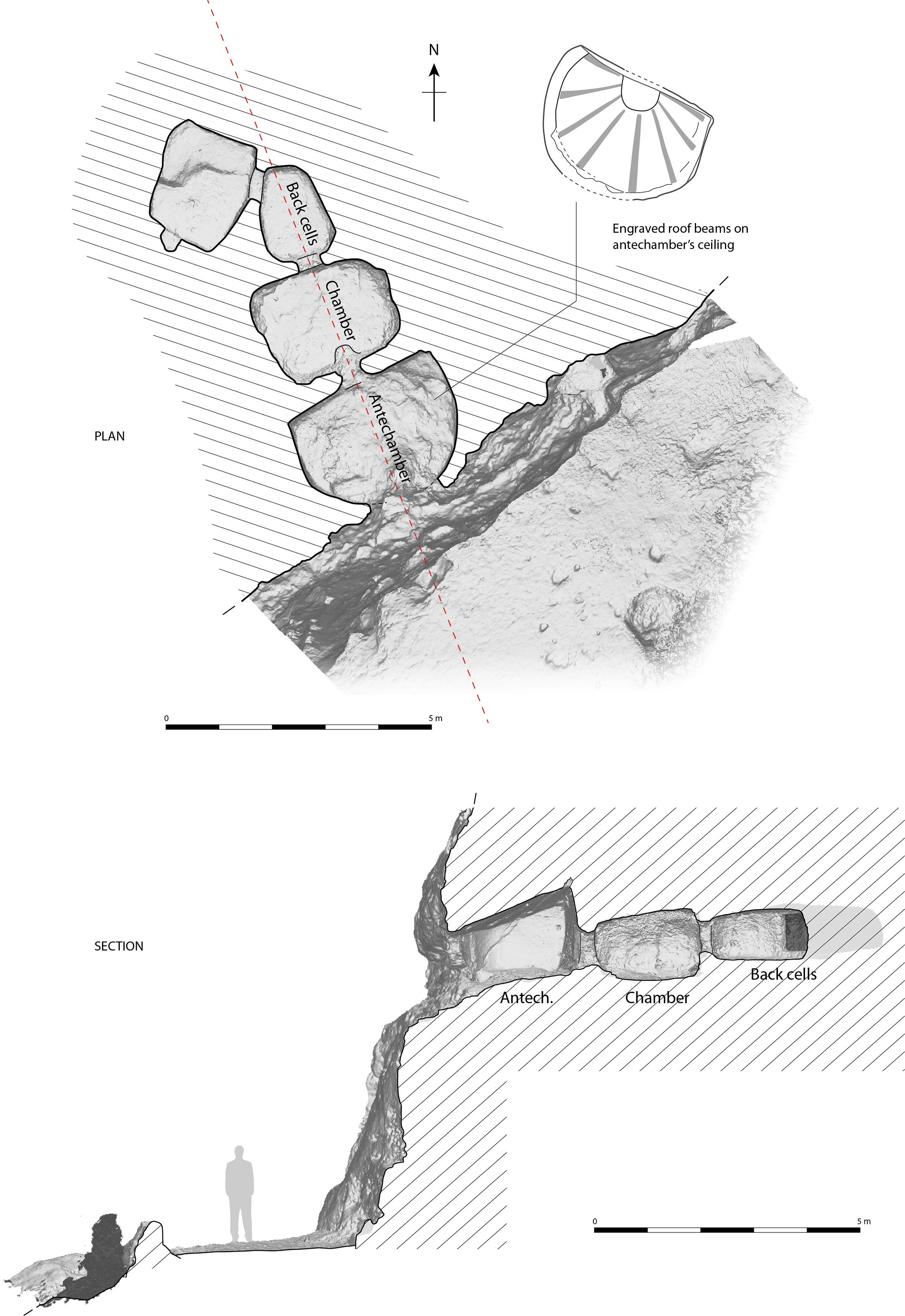
Fig. 8. Mesu ‘e Montes Tomb 13: Plan and longitudinal cross-section (photogrammetry: Florian Soula; CAD: Guillaume Robin)
Tombs 3, 6, and 16 were reused during the Middle Bronze Age and were partly recut in this period. The original entrance of Tombs 3 and 16 was marked by the carving of a large architectural façade imitating the stelae standing at the front of Nuragic megalithic tombs, while the interiors of Tombs 3 and 6 were reconfigured each into a large, single, oval space. Such Bronze Age reappropriations of Neolithic rock-cut tombs are known in several cemeteries in Sardinia (Castaldi Reference Castaldi1975; Melis Reference Melis2014).
An isolated tomb of a potentially earlier date is located on the plateau of Monte Mannu, 300 m away from the rocky edge of Monte Mamas. Unlike the 18 tombs of Mesu ‘e Montes, the tomb of Monte Mannu is cut from the horizontal floor of the plateau, near its southern tip. The small tomb is composed of an access shaft or antechamber, leading down into an oval chamber with curved walls (a forno) (Fig. 9). This particular type of tomb is known in the Middle Neolithic cemetery of Cucurru S’Arriu (Oristano), which represents the oldest dated rock-cut tombs in Sardinia (and likely in the whole Central Mediterranean) (Santoni Reference Santoni2000). The isolated tomb of Monte Mannu in Ossi is quite disturbed and has never been excavated but it might represent the earliest rock-cut tomb in the area.

Fig. 9. Rock-cut tomb on the plateau of Monte Mannu: Plan and longitudinal cross-section (photogrammetry: Florian Soula; CAD: Guillaume Robin)
Location and orientation of the tombs
Although this is not an absolute rule, Late Neolithic rock-cut tombs in Sardinia are often found on rocky faces with a south or south-east aspect (González-García et al. Reference González-García, Zedda and Belmonte2014; Tanda Reference Tanda2015, 71). This shared cultural preference among Late Neolithic tomb builders probably explains the location and concentration of tombs along the south-east escarpment of Monte Mamas and, conversely, their absence in other rock faces available nearby. The cliff on the south-west edge of Monte Mannu, for instance, is composed of compact limestone equally suitable for tomb carving; however, it has a westerly aspect and, likely for this reason, was not selected to receive tombs.
Beyond location, an intriguing aspect is the orientation of the tombs themselves. The way this aspect has been approached so far in Sardinia is problematic in two ways. From a theoretical point of view, it is generally assumed that the orientation of domus de janas is simply a reflection of general symbolic concepts and belief systems. The frequent south-east orientation, for instance, is repeatedly interpreted as a reference to the setting sun, as a symbol of birth and regeneration of life intended to the dead (eg, Demartis Reference Demartis1991, 10; P. Melis Reference Melis2000a, 742–3; Atzeni et al. Reference Atzeni, Garau and Mura2014; Tanda Reference Tanda2015, 69–71). It has also been argued that it simply replicated the orientation of the houses of the living, as evidenced at Serra Linta (Tanda Reference Tanda2015, 71). Consequently, from a methodological point of view, tomb orientations have been approached in a vacuum: tomb azimuths are sometimes accurately recorded and represented in diagrams (eg González-García et al. Reference González-García, Zedda and Belmonte2014; Tanda Reference Tanda2015, 71), but the relationship between tomb alignments and actual landscape features observable in the field is ignored. We believe the latter elements are essential if one wants to tackle the cultural signification of tomb orientation. For instance, recent fieldwork by one of us in Mamoiada (Central Sardinia) has shown links between the orientation of rock-cut tombs and important prehistoric landmarks such as settlements, standing stone complexes, megalithic tombs, or agricultural valleys (Soula Reference Soula, Robin, D’Anna, Schmitt and Bailly2016).
What do we mean by orientation? In a previous work, one of us has argued that the architectural design of domus de janas was conceptually articulated around a virtual central axis. This axis is represented by the alignment of the symbolic doorway (on the chamber’s back wall) with the other doorways that sequence the access into the monument (entrance to the antechamber and to the chamber). Other symbolic elements, such as the carved ‘hearths’ or cup on the ground of the central chamber, were also placed on this central line (Robin Reference Robin2016). Here, we consider the central axis as the orientation line of the tombs (see dotted line in Figs 4 & 8).
The detailed georeferenced survey of the tombs at Mesu ‘e Montes enables us to make several observations. First, the orientation axis of the tombs is not always perpendicular (in plan) to the rock face of the escarpment: tombs are often cut at an oblique angle (see plan of tombs 1 and 13, Figs 4 & 8). This is slightly counter-intuitive from a constructional point of view: if one needs a tomb with wide chambers and extendable side cells, this requires as much flexibility as possible in terms of side spaces within the bedrock, which is best achieved with a central axis set perpendicularly to the rock face. The somewhat non-perpendicular orientation of the tomb axis, therefore, is not determined by needs of internal architectural development but by other factors.
Second, if we observe the orientation of all the tombs together in a general plan of the cemetery, one can notice that each of them has a slightly different azimuth, independent of the local configuration of the rock face and its aspect (Fig. 10). Overall, one interesting pattern can be highlighted: the majority of the orientation lines converge towards the northern part of the plateau of Monte Mannu, about 200 m across the Mesu ‘e Montes depression. The southernmost tombs in the escarpment (Nos 1 & 2) are slightly bearing off towards the east-south-east, while the northernmost tomb (No. 17) is clearly off-positioned towards the south-south-east. This convergence can actually be tested or experienced during a visit to the tombs: if one positions oneself against the back wall of the central chamber inside these tombs, one can look through the alignment of the rectangular doorways leading to the outside world and see that the same part of Monte Mannu tends to appear inside the ‘frame’, as if the tombs were all ‘looking’ at this particular element of the landscape (Fig. 11).
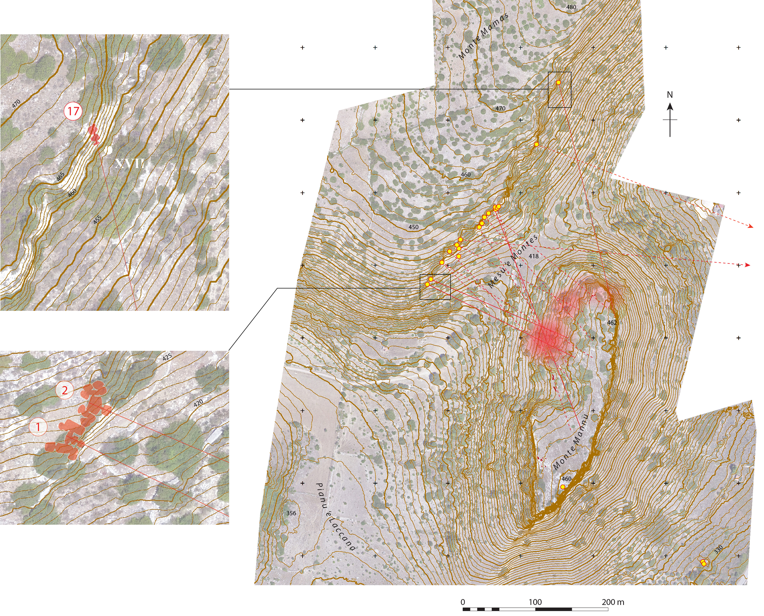
Fig. 10. Topographic map of the Mesu ‘e Montes-Monte Mannu archaeological complex, showing the relationship between the terrain and the orientations of the tombs (photogrammetry & GIS: Florian Soula; CAD: Guillaume Robin)

Fig. 11. Views of Monte Mannu from inside Tombs 1, 13, & 17 at Mesu ‘e Montes, and tomb 4 at S’Adde ‘e Asile (photos: Florian Soula, Guillaume Robin, & Kirsty Lilley)
Is this pattern deliberate or casual? Are the apparently awkward oblique orientations of the tombs a feature that was thoughtfully planned during the construction of the monuments in order to suit a communal cultural requirement (ie, a focus on Monte Mannu)? Or do they result from independent adaptations to specific local constraints or opportunities such as the geological properties or morphologies of the rock into which the tombs were dug? In Portugal, Sicily, or Malta, for instance, prehistoric rock-cut tombs were sometimes created around a pre-existing hole or crack in the rock (which was then extended); others were created in softer layers of the rock (easier to cut), located underneath harder rock layers that were used to form the ceiling of the hewn spaces (Jordão & Mendes Reference Jordão and Mendes2006, 52; Malone et al. Reference Malone, Stoddart, Bonanno and Trump2009, 80 – cited in Porqueddu Reference Porqueddu2018, 191–2; Di Stefano & Militello Reference Di Stefano and Militello2015, 63). Such opportunistic uses of geological variations within the rock has not been observed at Mesu ‘e Montes, although more expert analysis would be required. Nevertheless, if this were the case in Ossi, we feel it would only influence the topographic location of the tombs within the horizontally layered rock face, and not its plan orientation. If we take the example of tomb 1 (Fig. 4), the multiple chambers and cells together are occupying a surface of approximately 8 × 8 m within the bedrock: one could argue that the Neolithic stone workers could have equally used this space to create a different type of tomb with a range of different possible orientations.
One can conclude that the landscape orientations of the tombs at Mesu ‘e Montes were likely deliberate and specific, and organised in relation to the hilltop of Monte Mannu. This major landmark must have retained a particular significance for the Late Neolithic societies who have created the cemetery. What made Monte Mannu so important?
Monte Mannu settlement
In order to further contextualise the cemetery of Mesu ‘e Montes, systematic fieldwalking was carried out in the land parcels located within a 400 m radius around the tombs, for a total surface of 19 ha. The project initially hoped to cover a larger area but the unexpected density of surface artefacts recovered (15,037) made the process more intense and slower than planned. The results of the mapping exercise are presented in Fig. 12. The distribution of prehistoric pottery and worked flint and obsidian all show very important concentrations on the top surface and western slope of Monte Mannu. Minor concentrations can also be noted on the plateau of Monte Mamas right above Tombs 9–15, and further down on the terrace of Pianu ‘e Laccana. The plateau of Monte Mannu, ie, the area towards which the rock-cut tombs are aligned, used to be a densely occupied prehistoric settlement site.

Fig. 12. Distribution maps of surface finds at the Mesu ‘e Montes–Monte Mannu archaeological complex: prehistoric pottery (left), flint (centre), and obsidian (right) (photogrammetry & GIS: Florian Soula; CAD: Guillaume Robin)
Monte Mannu is a long oval limestone plateau of c. 3 ha, orientated north–south, with high cliffs along its eastern and south-western sides, and a steep access slope on its north-western side which faces Mesu ‘e Montes cemetery. Monte Mannu (‘big hill’) is the most dramatic and pre-eminent landscape feature in the whole area, and also a very strategic location that commends views over the fertile terraces of Sas Renas and Bores to the north-east, and the large distant valley of the Riu Mannu to the south-west which encompasses other clusters of rock-cut tombs. The limestone plateau is heavily eroded: a large part of the bedrock surface is exposed, and large fragments have collapsed from its edges due to differential erosion of the sandier bed on which it lies. The important weathering and erosion affecting the plateau explain the extensive dispersion of artefact material over the slopes of the hill and their relative scarcity on the high plateau itself where they originated.
The lithic artefacts include a large quantity of cores (198) which, together with the density of flakes, suggests intense stone knapping activity through time. The settlement may have specialised in the production of flint tools for the local area. Residents likely used flint pebbles extracted from the local sources in the Riu Mannu valley nearby (Soula & Guendon Reference Soula and Guendon2010). Several blades and a foliated arrowhead were also recovered, indicating occupations during the Late Neolithic and Chalcolithic periods. Pottery sherds were unfortunately very fragmented and eroded, but 31 diagnostic elements ranged in date from the Middle Neolithic to the Middle Bronze Age (4400–1300 BC). The tentative chronology of the Monte Mannu settlement, therefore, matches with the multiple phases of use of the cemetery of Mesu ‘e Montes (see above).
Some limited structural evidence was also identified in various parts of the site. Groups of post-holes cut into the rock were recorded on the southern part of the plateau where the bedrock is exposed. On the north-west edge of the plateau, where sedimentation is better preserved, a series of retaining walls and terraces, as well as fragmentary wall foundations, were also noted. The nature and date of these various surface structures are difficult to ascertain but exploratory trenches opened in 2019 have made it possible to uncover occupational layers and further structural evidence dating to the Early Copper Age and Middle Bronze Age, confirming the residential nature of the site and its long-term occupation.
Further excavation in future years should enable us to better date these occupation phases and hopefully better identify the structures. Nevertheless, the surface finds and the architectural features altogether suggest the presence of a large prehistoric settlement on Monte Mannu. The settlement is contemporary with the large cemetery of Mesu ‘e Montes. Both sites were very likely used by the same community, and their association was reinforced by the alignment of the tombs towards the residential plateau.
CASE-STUDY 2: S’ADDE ‘E ASILE
S’Adde ‘e Asile (‘the valley of the sheepfold’) is located 1.5 km north-east of Mesu ‘e Montes (Fig. 1). It is the second largest cemetery of the project area with a total of 12 tombs: six domus de janas, three tombs reused or created during the Middle Bronze Age (tombe a prospetto: Melis Reference Melis2014), as well as three unfinished tombs (Contu Reference Contu1969; Derudas Reference Derudas2000; Reference Derudas2004b) (Figs 13 & 14). The latter category refers to domus de janas whose carving out was interrupted during or after the creation of the entrance doorway, for unclear reasons. Archaeological excavations were conducted by the University of Sassari in 1984 in Tombs 4 and 5 (also called Tomba delle Clessidre and Tomba con Coppella), whose results have unfortunately not been published, as well as in Tomb 12 (Tomba a Trifoglio) where Bell Beaker pottery was recovered (Moravetti Reference Moravetti and Nicolis2001). Two decorated domus de janas of the site have attracted particular attention: the extensive Tomba Maggiore (Fig. 15) with its numerous carved bucrania (Tanda Reference Tanda1977), and Tomba delle Finistrelle with its carved and painted motifs (Demartis Reference Demartis1980). Tomba delle Clessidre, another densely decorated tomb with multiple carvings, had never been fully published before the present article (Figs 16–19) (Derudas Reference Derudas2004b, 42–5; Tanda Reference Tanda2015, 310). The tomb includes an open-air dromos leading to a circular antechamber with a cup carved at the centre of the floor surface. The antechamber gives access to a typical rectangular chamber with two pillars (one decorated with three carved bucrania: Fig. 17) and a symbolic doorway carved on its back wall. A series of burial cells are accessible from the side walls of the chamber. An unusual feature at Tomba delle Clessidre is the creation of additional cells accessible from a side wall of the antechamber (a feature also visible at Tomba Maggiore). The wall surface around the doorway leading to this side cell is covered by a complex arrangement of triangle and lozenge reliefs (Fig. 17), motifs that are frequently associated with doorways in Sardinian rock-cut tombs (Robin Reference Robin2016).

Fig. 13. Aerial view of S’Adde ‘e Asile from the south-east. Locations of the rock-cut tombs are indicated by squares (see Fig. 14 for numbering) (photo: Guillaume Robin)

Fig. 14. Topographic map of S’Adde ‘e Asile cemetery and its surroundings, showing the relationship between the orientations of the tombs and hilltop settlements (photogrammetry & GIS: Florian Soula; CAD: Guillaume Robin)

Fig. 15. Plan of Tomba Maggiore (Tomb 1) at S’Adde ‘e Asile (photogrammetry: Florian Soula; CAD: Guillaume Robin)

Fig. 16. Plan of Tomba delle Clessidre (Tomb 4) at S’Adde ‘e Asile (photogrammetry & CAD: Guillaume Robin)

Fig. 17. Tomba delle Clessidre (Tomb 4) at S’Adde ‘e Asile: Longitudinal cross-sections (photogrammetry & CAD: Guillaume Robin)

Fig. 18. Tomba delle Clessidre (Tomb 4) at S’Adde ‘e Asile: cross-sections (photogrammetry & CAD: Guillaume Robin)
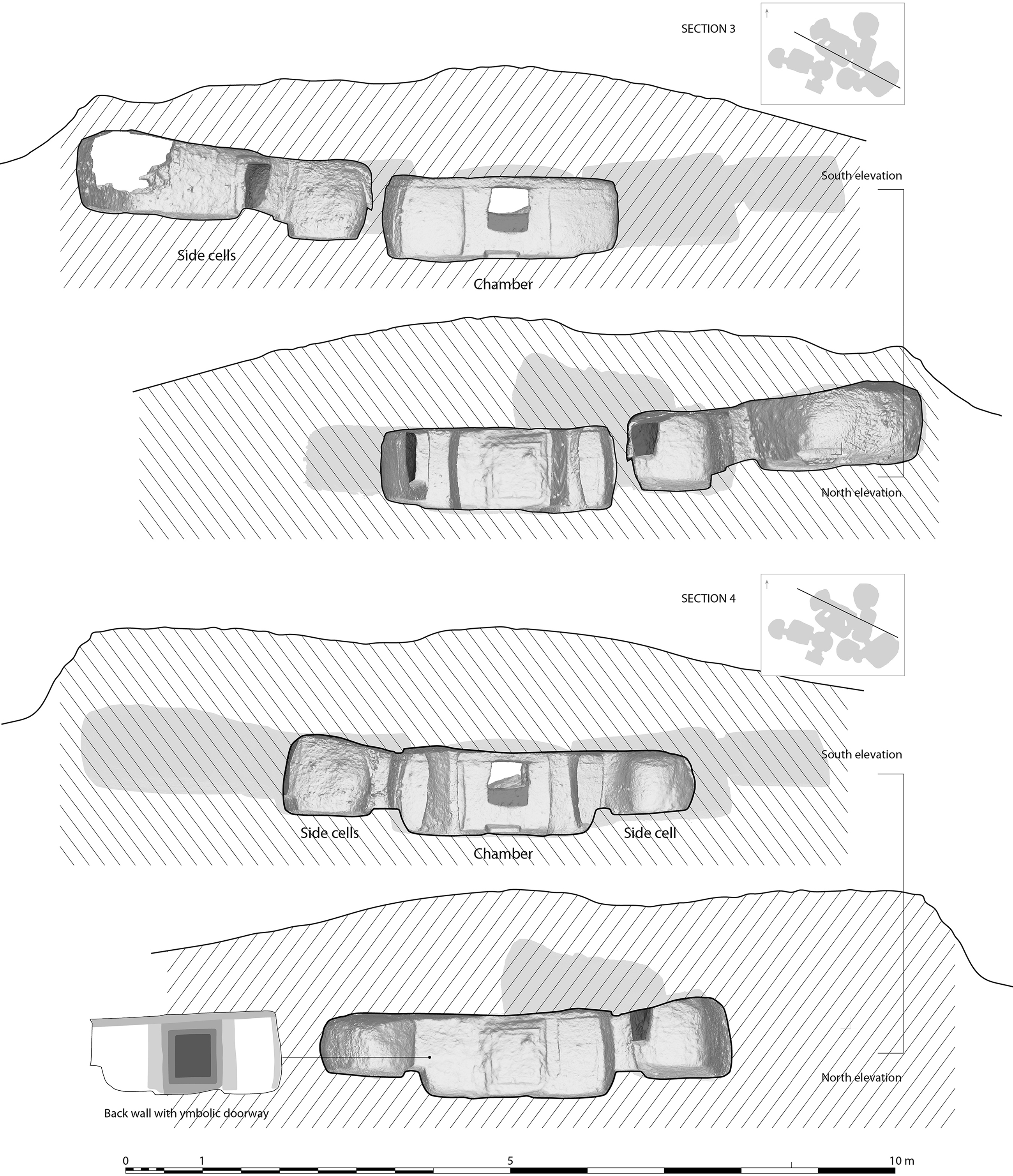
Fig. 19. Tomba delle Clessidre (Tomb 4) at S’Adde ‘e Asile: cross-sections (photogrammetry & CAD: Guillaume Robin)
The geology at S’Adde ‘e Asile is similar to that of Mesu ‘e Montes. The landform, however, is slightly different, which has influenced the configuration of the cemetery and the distribution of the tombs. The cemetery is positioned on the south-east slope of Monte Corona ‘e Teula, a formation that alternates limestone and marly-sandstone beds. These layers are affected by differential erosion, resulting in a series of short natural terraces with small outcropping limestone faces at different levels of the slope (Fig. 13). The tombs, created in these dispersed outcrops, are consequently distributed at different altitudes and locations over the slope, rather than being concentrated on a single rock bed as in Mesu ‘e Montes. The highest tombs (Tomba Maggiore and Tomba Corona ‘e Teula) sit at an altitude of 454 m, with the lowest one (Tomba a Trifoglio) at 408 m. The cemetery overall represents a surface of 4 ha (Fig. 14).
The wide geomorphological formation of Corona ‘e Teula offered a range of different possible tomb locations to the Late Neolithic people who created the cemetery. Limestone outcrops are distributed virtually all around its southern slopes, facing multiple azimuths from the west-south-west to the east-north-east, and at various altitudes from c. 400 m to 495 m amsl. Within this range of possibilities, tomb builders have only selected locations facing the south-south-east part of the horizon, as in Mesu ‘e Montes and other sites in Sardinia. However, unlike our previous case study, the lower half of the slope was preferred over its upper part.
Tombs at S’Adde ‘e Asile are located on the south-east slope of the hill, but they present various orientations, overlooking different parts of the surrounding landscape. Based on what has been observed at Mesu ‘e Montes, it is interesting to examine possible correlations between the orientations of the tombs and possible settlement locations in areas surrounding the cemetery. Fieldwalking was carried out in 2018 and proved more challenging than at Mesu ‘e Montes due to a denser vegetation cover. A few concentrations of artefacts, however, have been identified and geolocalised, as well as the absence of artefactual evidence in flat terraces that were potentially suitable for Late Neolithic settlements (see Fig. 14).
Seven tombs at S’Adde ‘e Asile have a south-east orientation (Nos 2, 5–8, 10, 12). These are looking over a remarkable canyon running north–south (today marking the boundary between the municipalities of Ossi and Florinas), and towards a hilltop formation called S’Utturinu (413 m amsl). This location corresponds to our most important concentration of surface finds (prehistoric pottery sherds, flint and obsidian flakes). The site of S’Utturinu is briefly mentioned in the literature as a possible Nuragic (Middle–Late Bronze Age) site, based on the presence of ruined stone structures (P. Melis Reference Melis2000b, 396; Merella Reference Merella2013, 248). However, evidence suggests that the site was certainly occupied over multiple periods, from the Late Neolithic to the Middle Bronze Age, as was Monte Mannu. The ruined stone structures are built on a limestone butte (c. 200 × 30 m large), with c. 10 m high cliff sides exposed on the north-east that include a rock-cut tomb. This isolated tomb has multiple chambers and was cut probably during the Late Neolithic, and likely reconfigured during the Middle Bronze Age (P. Melis Reference Melis2000a).
The highest tomb of the cemetery (Tomba Maggiore, 454 m amsl) presents a slightly different orientation (ESE). The tomb was not created from a vertical rock face but from the horizontal top surface of a large outcrop. The cutting of a long and wide dromos in front of the entrance enabled to open up a view of the distant landscape from the tomb’s interior (Fig. 15). This view, and the central axis of the tomb, are pointing to another possible prehistoric settlement area, called Bainzu Olia (Fig. 14). The site is located 620 m away from the tomb. It is a small hilltop with a similar altitude to Tomba Maggiore (449 m amsl). Bainzu Olia has not yet been surveyed as part of our project. It consists of a series of ruined stone structures, described as possibly Nuragic (P. Melis Reference Melis2000b, 396), part of which was built on top of a small limestone butte at the top of the hill.
Three other tombs at S’Adde ‘e Asile (Nos 3, 9, 11) are orientated to the south-south-east, in the direction of the agricultural plain of Sas Renas or S’Ena ‘e Littu. This area was not surveyed in 2018 and is in large part affected by a modern open-air sand quarry, but casual finds of Late Neolithic artefacts have been reported there (Merella Reference Merella2013, 15, 105–6).
Finally, Tomb 4 (Tomba delle Clessidre) has an unusual south-west azimuth, which seems awkward considering the aspect of the slope and the orientation of the other tombs in the cemetery. A visit inside the tomb provides a possible explanation: if one looks outside through the alignment of the antechamber and chamber doorways, one can clearly see the silhouette of the distant Monte Mannu (1.5 km away), cropped out from the rest of the landscape inside the frame of the tomb’s rectangular entrance (Fig. 11).Footnote 1
DISCUSSION
The Ossi project, although in its early stage, provides new information on so-far overlooked aspects of Sardinian prehistory: the landscape context and the social environment of rock-cut tomb cemeteries. The main outcome is a preliminary model (Fig. 20) showing rock-cut tombs and settlements interacting spatially and visually within a hilly landscape marked by limestone plateaux and erosion valleys. The main elements of this model are listed here:
-
Tombs are located on rocky hill slopes with a south-east aspect;
-
Tombs are deliberately orientated toward specific settled areas located within a 200–600 m range (up to 1.5 km in one occasion) from the cemeteries, and at a similar altitude to the tombs in the landscape;
-
Settlements favour hilltop locations, particularly small limestone plateaux or buttes with exposed cliff edges acting like natural podia;
-
Settlements are established at a certain distance from the cemeteries (200 m minimum) and separated from them by natural features such as valleys or canyons;
-
Settlements and cemeteries have long parallel biographies, with evidence for continuous use from the Middle/Late Neolithic to the Middle Bronze Age.

Fig. 20. Schematic cross-sections through the landscapes of Mesu ‘e Montes (top) and S’Adde ‘e Asile (bottom), showing the spatial and visual relationships between tombs and settlement sites
These findings have several implications for the study of prehistoric monuments and landscapes in Europe. The first concerns the orientation of ritual architectures. There is a long tradition of examining and interpreting the orientations of both megalithic tombs and hypogea from various countries (eg, Ruggles Reference Ruggles1999; Hoskin Reference Hoskin2001). There is a general consensus that orientations were deliberate and meaningful. However, most interpretations revolve around religious symbolism or cosmographic considerations. Orientations are typically interpreted in relation to particular celestial phenomena such as solstices, the equinox, or constellations, which were presumably central in prehistoric religious belief systems, ritual practices, calendars, or cosmologies (eg, MacKie Reference MacKie1997; Sauzade Reference Sauzade2000; Hoskin Reference Hoskin2008; Saletta Reference Saletta and Ruggles2011). It has also been argued that sunset orientations were aimed at producing particular light effects inside Neolithic burial monuments (Hensey Reference Hensey2008; González-García et al. Reference González-García, Vilas-Estévez, López–Romero and Mañana-Borrazás2019). Links between tomb orientations and landscape features such as mountains or coasts have also been highlighted, showing how the physical environment was integrated into the design and ritual use of the monuments (eg, Cumming et al. Reference Cummings, Jones and Watson2002; Scarre Reference Scarre and Scarre2002; Prendergast Reference Prendergast2016; Rogerio-Candelera et al. Reference Rogerio-Candelera, Bueno Ramírez, Balbín Behrmann, Dias, García Sanjuán, Larsson Coutinho, Lozano Rodríguez, Miller, Pike, Standish, Prudêncio, Rodrigues, De la Rosa Arranz and Gaspar2018). Nevertheless, the living and their dwellings are often absent from the picture (Richards & Jones Reference Richards and Jones2016, 9). Tomb orientations may have reflected cosmographical conceptualisations of the landscape, but also more practical concerns of social identities.
What did tomb orientation mean to Neolithic people in Ossi? Why had each tomb to be visually connected to a specific residential area? Sardinian domus de janas were collective burials: each tomb could be used over generations, presumably by the same social or kin group. The simplest explanation is that each tomb was aligned on the dwelling site of the social group who used it.
The landscape locations of tombs and settlement in Ossi were intricately related spatially and visually. If our model is correct, it was not any location in the environment that could be chosen. How were such principles applied in practice, for instance when a new community founded a village in the Riu Briai basin? Was the cemetery’s location decided first, and the village’s location afterward, or the other way around? Or did the community carefully select suitable ‘paired’ landscape locations at the same time (one for the cemetery and one for the village), which would fit these requirements as well as other essential criteria (proximity to water sources, arable lands, pastures, access to raw materials and exchange networks, etc)? These questions, unfortunately, are reaching well beyond the limit of our current data.
The data show, however, that there are more settlement sites than cemeteries in the study area. Therefore, the model cannot be reduced to a simple equation ‘1 village = 1 cemetery’. Instead, each cemetery was probably used predominantly by one settlement (Mesu ‘e Montes by Monte Mannu, and S’Adde ‘e Asile by S’Utturinu). However, each of them also had affiliations with several settlement sites of different sizes, dispersed within the same catchment area: the tombs of S’Adde ‘e Asile, for instance, are aligned to at least three different residential sites (Bainzu Olia, S’Utturinu, and Monte Mannu). Similarly, a major settlement site like Monte Mannu had affiliated tombs in more than one cemetery: Mesu ‘e Montes (Tombs 1–7, 9–15, 17) and S’Adde ‘e Asile (Tomba delle Clessidre).
Such cross-relations between villages and cemeteries within the Riu Briai basin suggest a certain level of social interactions and bounds between the different local Neolithic communities, probably through exchanges of goods and marriage partners. Multiple social affiliations may have therefore been expressed by both the alignment of a tomb and its location in a particular cemetery. Tomba delle Clessidre, for instance, may have been founded by an individual originating from the village of Monte Mannu (which is in the tomb’s alignment) but having married into the community of S’Utturinu (who ‘owned’ the cemetery of S’Adde ‘e Asile).
This offers interesting possibilities for interpreting Late Neolithic social organisation and the biography of cemetery sites in Sardinia. If the same village community was split into several groups (each with one collective tomb), how were these groups constituted: families? clans? The best ethnographic model that comes to mind are the house societies (sociétés à maisons) as defined by Lévi-Strauss (Reference Lévi-Strauss1975). The people of Tana Toraja in Indonesia, for instance, are organised into house kinship groups, whose members reside in several houses, sometimes in dispersed hamlets, but whose cohesion is materialised by a distinctive physical ‘house of origin’ (tongkonan). This house is paired with a collective burial chamber cut into a local rock face. One village community is composed of several house kin groups, who have their own tomb in a nearby cemetery. A member of a specific house can only be buried in his/her affiliated rock tomb (Waterson Reference Waterson1995). Rock-cut tombs in Late Neolithic Sardinia are known for their conspicuous decoration, which display a shared concern with imitating house interiors. Were they imitating specific kin group houses (see also Robin Reference Robin2017)?
The number and extent of side cells inside a domus de janas is often regarded as a proxy for burial uses over time and, therefore, as an index for the social longevity of the tomb. In Ossi there is a great diversity of tomb size and complexity. For instance, Tomba Maggiore in S’Adde ‘e Asile represents the highest number of chambers and cells together (18) in Sardinia. According to our survey, it is the only tomb affiliated to the settlement of Bainzu Olia. Based on these elements, one can infer that the Bainzu Olia community represented a single social group with a very long genealogical history. Conversely, Tomb 17 in Mesu ‘e Montes is a very small and simple monument with an antechamber and a tiny chamber. Considering both its size and its marginal position within the cemetery (Fig. 10), it was probably one of the latest domus de janas to be created at Mesu ‘e Montes. It might have belonged to one of the latest founded kin groups within the Monte Mannu community. Tombs 1–15, on the other side, probably belonged to the oldest social groups, considering their location (immediately facing the settlement) and their high number of burial cells.
Cemetery and settlement sites had remarkably long parallel biographies. Mesu ‘e Montes and S’Adde ‘e Asile both have tombs which (based on their typology) can be assigned to the Late Neolithic and Middle Bronze Age. Material culture found inside archaeologically excavated tombs suggests an uninterrupted use of the cemeteries during and between these periods. The evidence from the settlements of Monte Mannu and S’Utturinu similarly suggests a lengthy and perhaps continuous phase of occupation during the same period of time. This means that the relationship between rock-cut tombs and settlements may have persisted over several centuries from c. 4000 to 1300 cal bc. We cannot exclude the possibility, however, that shorter-term settlements occurred within the study area, with lesser archaeological visibility and with different spatial relations to the cemeteries.
A last area of discussion is the role of the landscape in framing social interactions between the dead and the living. Any human society has a choice over where to bury its dead, either within or away from the settlement. This choice often reflects the cultural status of the dead and the agency they are believed to exert over the community of the living (Parker Pearson Reference Parker Pearson1999, 129–30). In Sardinia, the dead must have had some importance, considering the time and energy devoted to creating and decorating the domus de janas. These monuments were designed not only for containing the dead, but also for repeated interactions between the dead and the living (Robin Reference Robin2016; Reference Robin2017). The landscape survey in Ossi shows that the dead were spatially separated from the villages by important landmarks such as valleys or canyons and, therefore, that their physical presence was probably perceived as polluting or problematic for other ritual reasons. But the dead were also permanently visible from the settlements. Even though rock-cut tombs are rather discreet monuments, their small, squared entrances were always in sight from the residential areas. Tombs were purposely orientated towards the residential areas as if the dead needed to be permanently ‘watching’ the living during their daily activities. It was apparently essential for Late Neolithic societies to maintain an uninterrupted connection with the dead, that they remained continuously reminded and mentally present among the living, rather than being secluded in hidden, remote locations of the landscape and only occasionally visited and remembered. This suggests that the dead retained some form of agency in the social life of the village communities. They were perhaps directly addressed and consulted when important decisions were made and their permanent surveillance could ensure that traditions were respected.
It is difficult to imagine how Ossi landscapes were actually used on a yearly basis (Ingold Reference Ingold2000; Robb Reference Robb2007, 98–118) and how dispersed activities outside the settlements were integrated into such a polarised environment. Contrasting with the evidence from Monte Mannu and S’Utturinu, small concentrations of surface artefacts were recorded on the plateaux of Monte Mamas and Monte Corona ‘e Teula (Figs 12 & 14). These were essentially lithics (with only small amount of pottery) and were not associated with structural evidence, which can be interpreted as regular but temporary activities rather than permanent domestic occupations. How did prehistoric communities use these large plateaux, strategically located over and behind the tombs? Did they go there to collect wood, or for herding, cultural or social gatherings? If these activities were contemporary with the use of the settlements and cemeteries, then villagers would have had to pass through the land of the dead to reach these plateaux, which could provide occasions for regular, informal commemorative acts. Investigating access routes to the settlement sites and how these affect visibility of the tombs represents a further area of research. At Monte Mannu, for instance, the only possible access is from the north-west, which requires walking along or underneath the rock face of Monte Mamas with all the tomb entrances.
CONCLUSION
The Ossi project focuses on a relatively small area of 3 × 3 km that corresponds to a single hydrographic basin rich in Late Neolithic rock-cut tombs, including four principal cemetery sites. Here we have presented the results of two fieldwork seasons that concentrated on two large cemeteries and their surrounding landscape. Results from both sites are consistent, showing patterns in the landscape location of cemeteries and settlements, and visual interactions between these sites across the physical environment. From these patterns a model is emerging in which tombs are grouped together in restricted hill slopes devoid of residential evidence; settlements, on the other hand, are established on small hilltops that are physically separated from the cemeteries by dramatic valleys. Cemeteries and settlements are physically separated, but remain visually connected, and the tombs themselves are deliberately aligned on specific settlement areas. The dead and the living are residing inside their own respective ‘villages’ but are permanently watching each other across the landscape.
The alignment of tombs to settlements is probably the most intriguing result of our survey. It is likely that several tombs in the area, including in the cemeteries of Monte Sa Jana and S’Isterridolzu, were not intended to be aligned towards specific settlement areas, or to anything in particular. But the pattern highlighted in this paper calls for explanations. Why was it important for Neolithic communities to see their settlements not only from the fore area in front of the tombs, but also from deep inside the tombs themselves? Such precise lines of sight were probably intended for the dead rather than the living. Unlike the living, who can walk in the landscape, the dead stay in their ‘houses’ and are not supposed to get out of them. The tomb alignment provided a way for them to stay ‘connected’ to their original village and house.
This model is only provisional and presents several limitations. It relies on surface survey from small portions of the study area and future survey may refine or alter patterns. In addition, our model does not have the pretention to apply universally throughout Sardinia, where hundreds of cemeteries are located in quite different geological landforms with their own specificities. However, we hope that it can be tested more thoroughly in the future, and perhaps foster further landscape study of rock-cut tombs in the island.
An important outcome of this project was the discovery of the settlement site of Monte Mannu. Trial trenches and geophysical survey carried out in 2019 have confirmed the residential nature of the site and its contemporaneous occupation with the cemetery of Mesu ‘e Montes. Further excavations are hoped to unravel more aspects of the village life of the communities who created these fascinating tombs.
The present paper focused on landscape and tomb design, and we hope it offers an original contribution to certain long-debated issues of European Neolithic archaeology: the landscape location of cemeteries and settlements, the orientation of burial monuments and ritual architectures, the place of the dead in society, the role of the landscape in framing ritual activities and social cosmographies, and the biography of large archaeological complexes.
Acknowledgements
This research was funded by the Carnegie Trust of the Universities of Scotland and by a Leslie Grinsell prize by the Prehistoric Society. Edinburgh students Tyler Nance, Mario Natante, Daniel Proven, and Matilde Quilici took part in the fieldwork, as did Tom DiBiase. We are very grateful to the Soprintendenza Archeologica di Sassari, the Comune di Ossi, and Nicola Castangia (Archeofoto Sardegna) for help, support, and collaboration. We would like to thank Robert Leighton and John Robb, who have provided useful comments on an earlier draft, as well as the three anonymous reviewers who have helped us improve this article.


