


Prologue
‘Herostratus’ was a young Greek who on the 21 July 356 bc set fire to the temple of Artemis at Ephesus in present western Turkey in order to achieve fame. The temple was considered one of the Seven Wonders of the Ancient World, and Herostratus proudly proclaimed his deed. In order to dissuade others from doing the same Herostratus was sentenced to death, and it was forbidden to mention his name. However, his deed gained him immortality when it was described by the Greek historian Theopompus in his history, and it later entered common language in the wording: ‘Herostratic fame’, meaning fame at any cost, on unjustified and unstable grounds. In this article we propose that, in the Bronze Age in the second half of the 2nd millennium bc in South Scandinavia a ‘herostratic’ situation emerged, where communities and individuals in a collective, competitive strive, created an unstable situation, and paved the way for a later transformation of society, perhaps motivated by a wish to achieve eternal fame for ancestors and themselves.
Collective Constructions: A Historical and Theoretical Model
During history a few periods stand out by an astonishing collective investment in the building of monuments, many of which are still standing and mark the landscape. In South Scandinavia we can mention the construction of an estimated 20–30,000 megaliths during the period 3400–3100 bc, the construction of early stone build parish churches during the 12th century ad, or the building of 2000 dairies throughout Denmark by local farmers during a 20 year period in the later 19th century ad. We have chosen to analyse one such period of a collective outburst of monumental energy, the Early Bronze Age of Denmark, 1500–1150 bc, when an estimated 50,000 barrows were built, most of them over 2 m in height, several up to 5 m, and a few even larger. Our aim is to understand this phenomenon by analysing its various components in some detail, and its impact upon the local economy. Related to this we shall also look into the construction of long houses and their impact upon ecology and economy.
Theoretical model
Figure 1 presents the highly fluctuating intensity of barrow construction in Denmark over time, with two very marked peaks. The first peak corresponds with the introduction of the single grave barrow tradition in South Scandinavia at the beginning of the Single Grave Culture (SGC) in Jutland, while the other peak with global maximum is situated in period II of the Early Bronze Age (EBA). The intensity in these periods is manifestly higher than in the remaining term of barrow construction, and both peaks, in particular the EBA one, stand out as relatively short-lived culminations of just a couple of centuries. The graph also suggests that, together, these relatively brief but very intense periods account for the majority of barrows constructed in Denmark during the almost 4000 year long barrow building period.

Fig. 1 Graph of the relative frequency of barrow building in Denmark through later prehistory, from the onset of the single grave barrow tradition at around 2850 bc to the end of the Viking Age, ad 1000. Based on the data in Table 1 in Appendix 1 (graphics: Mads Kähler Holst)
Such periods of monumental construction raise a theoretical question as to the rationality of cosmological (ritual) and economic practices. During the intense building period barrows came to represent such a massive investment of resources in the form of labour, provisions for the participants, and offerings of fertile soil for the construction of the monument, that barrow building must have been a central part of the general economy of society during this period. It seems evident that there was a weighty rationale underlying this ritual aspect of Bronze Age life. Still, the question remains as to how this rationale related to other motives factored into the Bronze Age economy?
In previous studies of the economy of the Bronze Age two different emphases are recognised in, first, the prestige exchange with an assumed underlying political rationale characterised by a strong competitive behaviour (e.g. Earle Reference Earle2002), and secondly a domestic economy with an emphasis on a subsistence rationale with an implicitly stronger emphasis on cooperative behaviour (e.g. Rasmussen Reference Rasmussen1995; Kristiansen Reference Kristiansen2007).
To conceptualise the discussion of the roles of barrow construction in the general Bronze Age economy we thus propose to represent the economy in a model with three intimately linked rationales: ritual, political and domestic (Fig. 2).
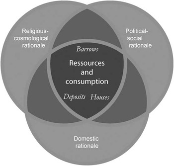
Fig. 2 Theoretical model of the overlapping rationales of the Bronze Age economy
These three rationales are obviously analytical categories related to our categorisations of the archaeological record. Consequently, the distinction between them is not meant to imply three discrete economies, but is intended to facilitate the analytical identification of both synergetic and counteracting motives and effects in the Bronze Age economy. Particularly, in recent discussions of the character of Bronze Age ritual and cosmology, there has been a clear tendency towards a holistic interpretation, where the rituals and religious concepts are considered to have been highly integrated in everyday practices, and where cosmology is defined as all-encompassing (Brück Reference Brück1999; Bradley Reference Bradley2005). These general arguments appear reasonable and have contributed to a significant shift away from the dominant perception of ritual as being the antithesis to a domestic economic rationale. However, the approach, entails a methodological risk of implicitly aligning motives with a harmonious, all-encompassing cosmology as the over-riding rationale, and an ascription of any negative effects to unintended consequences. In connection with the discussion of the periods of intense monumental construction it appears crucial to maintain the possibility of potentially opposing rationales, whose implementation in practice were not reconcilable.
By separating the different rationales and examining the links between cosmology and domestic and political dimensions in the economy we hope to be able to reach a better understanding of the balance between the rules of ancestors and superior beings, and the rules of nature and living humans. In short, we may be able to achieve a deeper insight into the priorities of Bronze Age people.
The different motives in the economy are associated with a flow of resources and a conversion between different forms of capital (Bourdieu Reference Bourdieu1977; Kopytoff Reference Kopytoff1986). The construction of barrows, for instance, entailed a permanent storage of grazing land in the barrows themselves. In return, the barrow stood out as a conspicuous token of the capacities of the organisers of the construction project, the communities of builders, the power of the interred ancestors, and the strong contact between ancestors and living communities. Thereby, a domestic resource was converted into a potential political resource via a ritual practice determined by a cosmological rationale revolving around an exchange between living and dead, gods and humans. In this respect, we propose that the cosmological motives of the episode of intensified barrow building initially supported a new political economy.
Ultimately, this transfer occurred at the expense of the domestic economy. The nutritious value of the land was lowered with each new stripping of sods/turves for the barrows. Nevertheless, initially there may very well have been an alignment of domestic and ritual rationales. Thus, in sandy western Jutland, where vulnerability to soil degradation was greatest, turf stripping for the barrows appears consistent with the land-use practices of heath maintenance witnessed by indications of systematic burnings (Odgaard Reference Odgaard1994; Karg Reference Karg2008). The relationship between the different motives in the economy is thus complex and dynamic. It is our claim that it is the interplay between the three rationales that explains the rise of barrow building and a new economy, just as it determines when it had to come to an end.
This theoretical approach will also be applied to analyse the rationality of house constructions. During the period 1900–1300 bc monumental, timber consuming longhouses were constructed, and from 1500 bc, parallel with the beginning of barrow construction, the buildings became three-aisled (having previously been two-aisled) in order to facilitate the stalling of cattle. However, the size of the largest houses were beyond practical needs, and the use of horizontal wall planks made them extremely timber consuming. Therefore, they exemplify the same kind of resource mobilisation as needed for barrow construction, and with similar effects on the environment.
In the following discussion, we will look in more detail at the consequences of the dramatic development in barrow construction through the Early Bronze Age, and how the distinction between the different rationales can be used in an explanation of that development. The first step is to take a closer look at the evidence of land-use as well as the organisation of the barrow construction event. Together they may provide an insight into the nature of the meeting of the different rationales.
Case Study 1: The Tobøl Barrow Group and Skelhøj
The construction of barrows and their effects
The 26 documented barrows of Tobøl in Southern Jutland along the Kongeå river near Ribe constitute a well-preserved group and several of the barrows were once very large – more than 30 m in diameter and with heights 5–7.5 m. The barrow group is structured into two parts with the eastern part being the largest. The barrows in the western part are more scattered and cover a larger area. Among these large barrows is Skelhøj, which was completely excavated from 2002 to 2004. Several renowned archaeological Bronze Age finds have been recovered from the group. It is centrally located at the intersection between two main communication corridors – an east–west corridor provided by the navigable Kongeå and a north–south terrestrial line marked by numerous barrows forming long rows in the landscape (Boye Reference Boye1896; Thrane Reference Thrane1963a; Reference Thrane1963b; Holst et al. Reference Holst, Breuning-Madsen and Rasmussen2001; Reference Holst, Rasmussen and Breuning-Madsen2004) (Fig. 3).

Fig. 3 Map of the Tobøl-barrow group with the location of Skelhøj and the barrow sb. 93 indicated (graphics: Mads Kähler Holst)
Contemporary settlement activities have primarily been recorded on the south bank of the river. On the north bank domestic activities change character through time: Prior to barrow building they seem to have been concentrated on well-defined settlement sites, whereas, contemporary with barrow building, the finds reveal a much more scattered distribution (Laursen et al. Reference Laursen, Johansen, Holst and Rasmussen2003).
In several ways, the character of settlement contrasts with the centrality and concentration signaled by the conglomerate of large, specially constructed mounds dating to Montelius periods II and III. The resource related expenditure of effort at the outset of the most active, central, period of barrow construction cannot, therefore, be related to one particular settlement alone but must have had a significance which extended beyond the immediate hinterland.
The potential for the dating of barrows and burials in the Tobøl barrow group is relatively good and the chronological evidence may suggest a model for the development and structure of the barrow group. During the Single Grave culture and Late Neolithic periods (2850–1750 bc), barrows were probably only built at intervals of several generations. After Bronze Age period I (i.e. after 1500) the level of activity rose noticeably. It peaked in period II (1500–1300 bc), and period III (1300–1100 bc) exhibits a slight decrease in intensity. In both period II and III, at least one, and perhaps several barrows were built per generation. The picture reflects very well the general picture seen in South Scandinavia. However, the Tobøl group apparently differs in that the first, large peak in barrow building intensity seen elsewhere during the Single Grave Culture is not apparent here.
The long stable period in which barrows in the area were built at long intervals, gives the impression of continuity in the perception and use of the area and the overall structure of the landscape. This rhythm of activity was apparently transformed in period II where the activity level in the Tobøl area acquired a new and intense character, which lasted for a couple of generations. Much of the history of the barrow groups could thus lie within the memory of a few generations.
The landscape in which most of the barrows of the group were built was open and dominated by herbs and dwarf shrubs rather than trees. The most significant variation in the pollen diagrams is the relationship between heather and the grass-dominated common vegetation (Reference Søgaard and ChristensenSøgaard & Christensen in press). A number of plants indicate that the heath was cut or grazed and quantification of charcoal dust and evidence of the burning of heath plants underlines this picture of a heavily culturally-influenced landscape with indications of grazing pressure and cultivation of the heather grassland (Karg Reference Karg2008). At the time when intensive barrow construction began the area was well overgrown with a vegetation cover that could function as a provider of turf for the barrows.
There is a good deal of evidence concerning the systematics of the production of the building material for the barrows. Beneath the barrow sb. 93 it could be seen that a large part of the original topsoil had been removed prior to the construction. It is also possible that a system of ard marks found underneath Skelhøj should be linked to turf procurement. The distance between the parallel furrows of ard marks is typically 25–35 cm, which corresponds very well to the width of a turf. Under sb. 93, remains were found of a bank or field boundary which might be linked with the turf-stripping system. On one side of the bank traces could be seen of the cutting of sods or turfs in the original topsoil – these were clearly present up to the bank but not on the other side of it.
It seems likely that there existed in the area one or more forms of dividing up the landscape and that turf cutting followed these divisions in systematised and intentional ways. Pedological analyses of the turves in the barrows indicated that they were occasionally procured within areas which had been previously stripped, and this repeated turf cutting may also be seen as an indication of a deliberate strategy. Observations of intensive pressure and lack of regeneration between individual turf stripping campaigns are seen in the results of the pedological investigations (Reference Koue and Breuning-MadsenKoue & Breuning-Madsen in press).
An impression can be gained of the extent of the turf cutting and its influence on the landscape by modelling the amount of turf used in the construction of the individual barrows. Each barrow built implied the stripping of 0.5–10 hectares of land. For the whole barrow group this meant somewhere between 75 and 100 hectares of land that was removed from the sphere of cultivation (Fig. 4).

Fig. 4 Model of the area of sod/turf consumption required for the construction of barrows in the Tobøl barrow group, provided the turves were procured in the immediate vicinity on dry ground. The barrows are assigned to one of three categories of barrow sizes based on archival information on the barrows and archaeological investigations (graphics: Peter Jensen & Mads Kähler Holst)
A very clear difference is apparent between the eastern and western parts of the barrow group. In the western part it was potentially possible to strip turf for all the known mounds without any overlap. Therefore, only parts of the area had to be taken out of agricultural use in turn to provide material for the barrows and subsequent regeneration. In the eastern part the picture is completely different. The many overlaps here show clearly that it was necessary either to strip turf off the same area several times or to obtain building material from further afield. In any circumstances it underlines the assumption that it was impossible to combine the dramatic intensification of barrow construction with normal domestic exploitation in this area.
During the course of the Single Grave Culture and the Late Neolithic, as the exploitation of the area as well as the settlement pattern changed, the most intensively cultivated and settled areas of the preceding Neolithic period became the central barrow building area. Landscape analyses conducted by the institute of Geography at the University of Copenhagen have concluded that only small and narrow areas were suitable for cultivation (Reference Koue and Breuning-MadsenKoue & Breuning-Madsen in press). However, these were exactly the areas used for barrow building: The barrows at Tobøl were not built on marginal land. From a domestic rationale this was destructive behaviour. On the other hand, turf procurement and the maintenance of grazing land with regular burnings of the heath exhibit rather similar exploitation patterns and may, to a certain extent, be seen as comprising a compatible structure. In the light of this, it is interesting that the emergence of barrow construction in both periods coincided with altered strategies for land use with apparently greater emphasis on grazing than cultivation. A similar pattern of changed land use could be observed in Thy (Kristiansen Reference Kristiansen1998; see also Fig. 10).

Fig. 10 Generalised pollen diagram from southern Thy (after Steinberg Reference Steinberg1997), which shows two significant episodes of forest decline: the beginning of the 3rd millennium bc (Single Grave Culture/SGC) and the beginning of the Early/Middle Bronze Age. After this period the deforested, open Thy landscape of historical times was established. The diagram corresponds rather closely to Figure 1 with its two peak periods of barrow building. Forest decimation, barrow building, and settlement expansion/consolidation went hand in hand
Until the final phase in periods II and III, barrow construction was easily reconciled with domestic exploitation of the landscape. However, during the culmination, the many barrows, and the events that unfolded around them over a very short span of time, implied that large parts of the local landscape became unsuited for cultivation use. In this way, even though the domestic and ritual rationale may have had a shared offspring, the many building events led to growing conflict between them and, in the end, to an unsustainable environmental situation.
In this connection, it is noteworthy that there are no, or only very few, archaeological remains that bear witness to exploitation of the landscape during the Late Bronze Age, despite intense surveys in the area (Laursen et al. Reference Laursen, Johansen, Holst and Rasmussen2003). One kilometre to the north-west there is a hillock grave cemetery comprising 35 small barrows dated to Late Bronze Age period VI and Early Pre-Iron Age period I. The number of graves and the relatively narrow time frame suggest a nearby settlement of some extent, but this is outside the core area of the barrow group itself, and 500–700 years after the end of barrow construction. Apparently, the area was largely abandoned. This is remarkable as the central location of the area lies at the intersection of the main communication corridors through the landscape, and it appears to be an obvious possibility that this collapse could have been related to the environmental effects of barrow building.
Barrow construction and the devastation of farmland
The Tobøl barrow group provides an insight into the effects of barrow building on a local scale. We shall proceed with an estimate of the magnitude of barrow construction and its effect on Bronze Age environment on an overall scale encompassing the entire Danish region.
A conservative estimate based on the Danish Archaeological Database (Kulturarvsstyrelsen 2008), supplemented with additional information from air photography in select regions of previously unrecorded ploughed barrows, suggests a minimum of 50,000 barrows being constructed during the period 1500–1150 bc. There are barrows recorded in nearly all 2000 parishes in Denmark, but some areas were rather sparsely settled during the Bronze Age, especially the heavy moraine in eastern Jutland, on Funen and Zealand. A Bronze Age barrow consumed an average of 2–3 ha of grassland, making of total of 100–150,000 hectares potential farmland being devastated during the period 1500/1450–1150 bc. The majority of these activities are thought to have taken place within settlement areas, and so it had significant consequences for the productive potential of the local economy, as exemplified by the Tobøl area.
If we take the period of intensive barrow construction to have lasted between 300 and 350 years, a yearly minimum average of 150 new barrows had to be built. During the culmination of the barrow construction period the number was significantly higher. If we assume that at least 1000 parishes were more densely settled (out of 2000 for all of Denmark), the building of a barrow would have been a regularly recurring event in every parish. At least every 10 years a new barrow was founded, and if the enlargements of existing barrows in connection with secondary burials are considered, the frequency obviously becomes significantly higher. It seems justified to claim that barrow construction was an integral practice in Bronze Age society during this period.
From an overall perspective, the exploitation of resources in connection with the barrows could by all accounts, be relatively easily sustained. The total area required for barrow building was relatively minor compared to the large unexploited areas lying within the overall settlement community. It is the uneven distribution of settlements and barrows, which is responsible for barrow construction having a significant environmental effect. In areas such as Thy (discussed in more detail below) settlement density appears to have exceeded one farm per square kilometre; here ecological adaptability was reduced, and the devastation involved in barrow construction could be felt.
Collective construction versus individual commemoration
The barrows have often been interpreted as representing part of competitive strategies, with their conspicuous investment of resources associated with the burial of one single individual, and the ensuing marked monumentality. At the same time it is evident that their construction required extensive cooperation, not least in the case of the great mounds of more than 25 m diameter, which became relatively numerous in the Early Bronze Age. The barrows are, in this way, situated between two social strategies, which in many respects can be seen as opposing. An underlying assumption that the two strategies are associated with different types of social groups can often be traced. The cooperative behaviour is group supportive and is consequently seen as an intra-group phenomenon while the competitive behaviour is demarcating and considered to represent strategies between groups. It is, however, an open question as to how well defined and discrete groups actually were in the Early Bronze Age. There is a normative variation in burial equipment, which has been interpreted as indicating institutionalised distinctions between ritual chiefs and warrior chiefs (Kristiansen Reference Kristiansen1984). These differences, however, were shared throughout south Scandinavia. Geographically, it has been difficult to identify distinctly separate groups, either spatially in the settlement pattern or stylistically in terms of material culture. Even if small regional differences are recognisable, these appear to be more variations on a common theme than distinct demarcation (Asingh & Rasmussen Reference Asingh and Rasmussen1989; Rønne Reference Rønne1989; Koch Reference Koch1992; Johansen et al. Reference Johansen, Laursen and Holst2004). This applies not least to Jutland, which is characterised by both highly regularised artefact compositions and a dispersed settlement pattern. Consequently, the possibility clearly exists that group affiliation was dynamic and relatively open. If so, the cooperative and competitive discourses could potentially collide at specific events such as the construction of barrows.
An analysis of the organisation of barrow construction may provide a better idea of how the cooperative and competitive elements were balanced (Holst et al. Reference Holst, Rasmussen and Breuning-Madsen2004; Goldhahn Reference Goldhahn2006; Oestigaard & Goldhahn Reference Oestigaard and Goldhahn2006; Holst & Rasmussen Reference Holst and Rasmussen2012). However, excavation of a barrow does not provide a direct window into how its construction was organised. Even if barrows, in many ways, appear as an obvious source for the study of cooperation in the Bronze Age, their testimony is still fragmented and partial, and dependent on our excavation strategy and the state of preservation.
From 2002 to 2004 excavation of the great barrow Skelhøj within the Tobøl barrow group provided one of the rare occasions where a detailed insight into the construction and environment of the barrows could be obtained. Skelhøj was the first scheduled great barrow to be completely excavated in Denmark for pure research reasons since the Protection of Nature Act in 1937. It is radiocarbon dated to the 15th century bc, and its preserved size was 30 m in diameter and 5 m in height. The mound was investigated by a series of sections and plans through the monument (Fig. 5). Excavation revealed a complex building sequence and also allowed reconstruction of the basic organisation of the work including the basic principles of cooperation (Holst et al. Reference Holst, Rasmussen and Breuning-Madsen2004; Holst & Rasmussen Reference Holst and Rasmussen2012). The barrow was constructed in one continuous process, without recognisable intermissions. The exact duration of the work is difficult to estimate, but it may have been completed within as short a time span as a few months.

Fig. 5 The Early Bronze Age barrow Skelhøj during excavation in 2002 with the shape characterised by the various sections used to dissect the barrow (photo: Mads Kähler Holst)
Our characterisation of the cooperation required for the construction of Skelhøj is based on identification of three components. First, the considered objectives and intentions of the barrow builders; secondly, the organisation of the participants; and thirdly their practices and procedures within the construction sequence (Holst & Rasmussen Reference Holst and Rasmussen2012).
1) The existence of an idea and a plan of the barrow seem to penetrate the monument from the beginning of construction. Even before the coffin was positioned, a structure was imposed on the monument in the form of a segmentary ‘pie-division’ of the building site with its centre in what was to become the central burial (Fig. 6). Furthermore, the burial was aligned with the east–west axis of the pie-division in accordance with a predominant east–west symbolism evident in a large number of Early Bronze Age barrows. This is generally assumed to reflect a metaphorical link between burial architecture and a cosmology, in which the journey of the sun occupied a prominent position (Randsborg & Nybo Reference Randsborg and Nybo1986; Kaul Reference Kaul1998; Goldhahn Reference Goldhahn2005, 45ff). In Skelhøj the metaphor seems particularly strongly expressed, as the segmental division together with the circular form of the barrow establishes a spoked-wheel template on the building site: the spoked-wheel being a frequent symbol in the iconography of the Bronze Age, where it is generally assumed to represent a central aspect of cosmology such as the sun and a prominent repetitive or cyclical concept of the world (Thrane Reference Thrane1963a; Tilley Reference Tilley1999; Kaul Reference Kaul2004). In this way, the fundamental architecture of the barrow is a physical manifestation of a cosmological rationale.

Fig. 6 The overall architecture of Skelhøj as it appears in plan. Barrow construction was organised around an eight-spoked wheel structure with strong cosmological references defined from the onset of the building and respected throughout the construction process. Scale 1:200 (graphics: Mads Kähler Holst)
2) This structure, however, had wider implications than reference to cosmology. It is also the outcome and achievement of social effort and orchestrated performance of labour. Through the construction process, the cosmological rationale came to govern building practices of the mound as it acted as a physical division of the building work. All actions in the building process respected this initial segmentation of the building ground. Varying provenance of the turves, separate approach pathways, and small variations in basic building practices from segment to segment, all point towards the segments also representing discrete groups of builders having responsibility for construction of the individual segments. Segmentation serves to effect a clear separation of different building groups. Nevertheless, building within the different segments followed the same basic course, which can be seen clearly in the main sections through the barrow (Fig. 7). As a first stage, a primary barrow cover was constructed around and over the central burial. This was then followed, either immediately or after only a short intermission, by a series of four further skins or shells of mound material, gradually increasing the size of the barrow.
Fig. 7 N–S section through Skelhøj with indication of the main construction stages. All stages were erected in a continuous building sequence. Scale 1:200 (graphics: Mads Kähler Holst)
3) The architectural plan thus had two overlying dimensions: a dimension of labour division, represented by the radial segmentation of the site and another dimension structuring the progression of the work, which was manifested in the sequence of shells.


Recording of the lay-out of the turves suggests the basic building routines employed by the workers within each segment. The building teams largely operated independently of each other. Construction of each segment was initiated by demarcation of the outer boundary with a row of turves. The space between this row and the previous shell was then filled by carefully constructing further rows on the inside. In the next layer the procedure was repeated, and building directions were maintained. Simply by following these principles, the shape of the mound could be maintained without the need for extended control or coordination of the individual segments.
The architectonic plans and practical building principles should, in consequence, result in the intended form and structure of the monument, provided that problems and irregularities did not arise during construction. However, trouble naturally did arise, evidently on numerous occasions. Problems were mainly associated with maintenance of the prescribed geometrical order in the barrow. Variations in turf size and shape led to uneven surfaces, whose irregularity had ‘knock on’ effects as the barrow size increased: there were small slides and erosion events resulting from heavy rainfall, and any lack in coordination of construction in the different segments caused asymmetry.
An individual solution for each of these problems can be identified. Even surfaces were re-established by establishing a break in the turf row routines so a new level surface could be established. Erosion deposits at the base were smoothed out before new shells were initiated and supports were added to prevent further slides. Errors at the abutment of segments were corrected by defining new curvatures at the commencement of a new shell. Generally, the repairs took place at specific points in time; that is, between the routines either at the commencement of a new layer or of a new shell.
The number of people participating in the event and its duration is difficult to estimate. Episodes of high rainfall can be identified as wash layers in the sections of the barrow, and they suggest (with some uncertainty) that construction took place within perhaps a few months. The narrow work surfaces of the shells can only have allowed a limited number of people to operate on each segment at a time which, in combination with the supposed duration of building, may suggest a total number of participants of between 100 and a few hundred people.
The nature of barrow cooperation and the mobilisation of labour
Skelhøj reveals a rigidly structured, but also strongly purposeful, organisation and construction sequence. At first glance, the organisation of barrow construction appears highly complex. A primary barrow stage and four shells with eight segments in each amount to 40 different construction parts. But, considering it from an operational angle, there may be very good reasons why the organisation ended up like this. All the various construction principles can be seen to support two major purposes. First, they maintain the geometric symmetry of the barrow. Secondly, they facilitate the logistics and practical cooperation.
The logistics and practical cooperation are also supported by the routines adopted, but primarily by the segmental division which provided a clear structuring of the participants during the construction event. If we consider cooperation between the assumed groups, the independence of each group is a prominent feature. They follow the same rules and construction sequence, and as such the independence is not autonomous, but there is a strong symbolic as well as practical segregation. The work is organised in a way that maximises the independent operation of these groups at the expense of a more centralised coordination of the barrow-building operation. This happens not by granting them complete autonomy but, on the contrary, by establishing some very simple routines, which all teams must follow rigidly. The groups share the abstract planning and the extended control is minimised.
Operations within the groups seem to be characterised by well-developed and integrated cooperation. Individuals are not evident in the basic building practices, and the regularity of the turf-laying suggests a very fluent procedure, which was only reluctantly interrupted when modifications were required.
The evident cooperation at Skelhøj is, in this way, based upon what may be termed a nested, decentralised division of the builders into groups, with the individual groups operating largely independently but still with some form of superior body exercising limited and targeted control, apparently not of the building styles of the individual groups, but of the overall shape and mutual coherence of the result of their efforts. It is a type of organisation which represents a middle course between a centrally controlled and enforced way of cooperating and an entirely decentralised solution with the individual groups operating autonomously, and which seems to have ensured efficient and stable cooperation for the numerous participants.
The contrast between this integrated cooperation within the groups and the accentuated segregation of the segment groups makes it reasonable to suggest that this group structure existed beyond the barrow-building event. They must represent entities who were accustomed to cooperating and within which the basic roles and principles of coordination were already established. The most obvious interpretation would appear to be that there was a link between the segment groups in the barrow and settlement groups in society beyond.
The cooperative aspects of the barrow indicate the important role that building activities played in establishing a larger group identity. It respected existing groups, and the cooperation had strong references to existing social groups and practices within them. In fact, to a large extent, it seems to have been a relatively simple combination of these, while the inter-group cooperation appears comparatively undeveloped and untested. Nevertheless, the combination had a complex outcome, and it also inserted and related the groups into an overall cosmological structure. In this way, in many respects the large barrows constituted a new form of practical cooperation, which may have also established a model for other types of interaction in the Bronze Age, thereby playing a role in the formation of social structures, rather than simply being a reflection of existing structures. As such, the barrows made sense from both religious-cosmological and political rationales, and these two aspects may hardly have been discernable. It may be that this concurrence of rationales became so strong, that it outweighed the significant costs and the domestic rationale. The building of the barrows meant an indisputable investment of resources i.e. the substance of the workers, the immediate impact on the soil, and, not least, the long-term degenerating effect on the landscape.
However, barrows were not the only collective construction activity that took its toll on both ecology and economy. Timber was needed for the thousands of long houses, many of which had rather large proportions and were particularly timber consuming. The practice of grounding the timber posts in post-holes meant they had to be renewed at regular intervals. We shall therefore now look more closely into the organisation of the household and its demands on the remaining forests.
Case Study 2: Thy and The Legård and Bjerre Enge Long Houses
The Thy project has provided a high resolution archaeological and ecological model of the organisation of landscape, settlement, and households during the period 1450–1200 bc (Earle et al. Reference Earle, Bech, Kristiansen, Aperlo, Kelertas and Steinberg1998; Kristiansen Reference Kristiansen1998; Bech & Mikkelsen Reference Bech and Mikkelsen1999; Reference Bech, Eriksen and KristiansenBech et al. in press). By combining pollen analysis at both regional and local levels with field survey and excavations of farmsteads with exceptional preservation it is possible to open a window on changes in local environment and settlement in two locations: at Legård and in Bjerre Enge. At the Legård site a large, high status farm with stalled cattle was excavated; at Bjerre Enge a local community of smaller farms with exceptional preservation of wood was excavated.
The house-(hold) as social institution
In a recent work Anna Gröhn (Reference Gröhn2004) makes an in-depth analysis of the social role of Bronze Age house architecture, which has been followed up further by a complete re-analysis of Bronze Age houses, by Magnus Artursson (Reference Artursson2005; Reference Artursson2009; also Streiffert Reference Streiffert2005), and households, by Marie Louise Stig Sørensen (Reference Sørensen2010). We can now delineate the history of long houses and the size of households in some detail (Earle & Kristiansen Reference Earle and Kristiansen2010).
Ethnographical and archaeological research on houses and households has pointed out that investment in house constructions of some complexity often are linked to a similar complex use of, and investments in, the landscape (Earle Reference Earle2002; Gröhn Reference Gröhn2004). Within such a context the house becomes a social and political institution, and its biography is linked to the life history of the household and its head (Gerritsen Reference Gerritsen1999). The death of the head of the household marks a critical moment of transmission. In the Early Bronze Age such an occasion was apparently sometimes used to take down the house and construct a barrow over it in order to unify the dead with his or her house in the afterlife (Svanberg Reference Svanberg2005; Reference Svanberg2007). In this way a reference to the household was anchored in the landscape beyond the duration of the house and the significance of the household was merged with the connotations of the barrow.
From this we may conclude that the household during the Bronze Age was an important social, economic, and symbolic (metaphorical) institution. Settlement structure and architectural variability is therefore an important point of departure for understanding the role of the household as a social institution.
The known Neolithic houses of the Early and Middle Neolithic are two aisled structures of rather moderate size. At the transition to the Late Neolithic, around 2300 bc a significant change in house architecture can be recognised. Variability increases between small and large houses (Nielsen Reference Nielsen1999, figs 2–7; Björhem Reference Björhem2003, fig. 4; Gröhn Reference Gröhn2004, table 10; Artursson Reference Artursson2005, fig. 1), and this development accelerated through the Late Neolithic/Early Bronze Age.
After 2000 bc some long houses become highly elaborate, and their size, architectural regularity, and internal complexity correspond to new economic and social needs (Nielsen Reference Nielsen1999, fig. 9; Artursson Reference Artursson2005, fig. 2). The length of the largest houses increases up to 30–50 m but, most significantly, the new large houses are also wider than the smaller ones: 8–10 m, compared to 5–7.5 m. This is, perhaps, the most visible and important change, as it adds space to the houses more effectively than increased length and it adds monumentality to the internal space/rooms. The new architecture was introduced from the Unetice Culture in Central Europe, and used full timber walls in the form of horizontal plank walls (Nielsen Reference Nielsen1999, 10).

Fig. 9 Timber consumption for the construction of the Legård long house, divided into trees of different size, and their number
The new large long houses introduce a whole new concept of housing and households. The large houses probably served as a focal point for a larger community than the smaller houses, and new forms of social behaviour and etiquette could be displayed inside the house. In this respect the large houses constituted a redefinition of the household as social and political institution. Thus, the new house architecture signalled important social changes and entailed a clear relation with Central Europe especially after 2000 bc. This development anticipated a major social and economic transformation after 1500 bc, when a new more elaborate house architecture (three aisled instead of two aisled) emerged and the intensive barrow-building period began.
The high degree of regularity in house structure, despite variations in size, is seen to reflect an institutionalised use of space that became more complex and hierarchical with the three aisled houses around 1500 bc (Middle Bronze Age in Central Europe, Late Early Bronze Age in Scandinavia, Montelius period II). This goes hand in hand with a more structured land-use, where it can be demonstrated in some areas that farm units, fields, and cattle tracks were demarcated with fences (Fokkens Reference Fokkens2005, figs 18.15–16; Knippenberg & Jongste Reference Knippenberg and Jongste2005, fig. 6:23). In Thy we also find small animal pens, as well as larger animal enclosures (Bech Reference Bech1997) linked to individual farms, although still in small numbers. Some researchers see this as being part of a complete restructuring of society, that was also implemented economically in a new farm lay out and land-use (Kristiansen Reference Kristiansen1998; Arnoldussen & Fontijn Reference Arnoldussen and Fontijn2005). While this may be true for parts of north-western Europe, the more fertile moraine landscapes of southern Scandinavia exhibit greater continuity in settlement structure. We may have to contend with two ecological/economic trajectories in northern Europe, which shared the basic components of social and religious organisation, but whose long-term economic and demographic conditions differed, as expressed in different strategies of land-use (Kristiansen Reference Kristiansen1978, fig. 11). The development discussed here is primarily relevant to the western part of south Scandinavia (and north-western Europe).

Fig. 11 Preserved roof-supporting post with axe cut marks from Bjerre site 6 (photo: Jens-Henrik Bech)
However, there is also continuity in the use of space/activity areas in the Bronze Age farms from two aisled houses to three aisled houses. Thus the internal divisions into living sections and barns or byres can now be more safely documented in some houses, such as Brødrene Gram (Ethelberg Reference Ethelberg2000), and in the Netherlands (Fokkens Reference Fokkens2005). However, variability increased, both functionally and in terms of size after 1500 bc. The largest houses are now 10 × 50 m, as is best documented in southern Jutland. Several of the large long houses were extended, reflecting the social and economic dynamics of individual households (Ethelberg Reference Ethelberg2000, fig. 29; Gröhn Reference Gröhn2004, table 17). In Thy it can be documented that such extensions were not uncommon, and account for some of the farms with two living sections, such as Fårtoft (Bech Reference Bech2012, fig. 9A; Bech & Olsen Reference Bech and Olsen2013, fig. 13A). This dynamic in the life history of farmhouses is in accordance with the evidence from barrow construction that we are dealing with a competitive society, where individual families could expand their household. Among the still rather few cases where indisputable cattle boxes are preserved in Early Bronze Age houses, the largest houses with byres all have horizontal plank walls, while smaller farms with cattle boxes have other wall constructions, mostly wattle and daub (Bech & Olsen Reference Bech and Olsen2013, fig. 11A–B). In general they are wider, from 7 to 8 m, than many other Early Bronze Age houses where no clear byres have been documented. We should probably expect that more of these farms had cattle boxes because the post-holes are insubstantial and can easily disappear through ploughing or be overlooked during excavation. The ownership of cattle also forges a link with the burial ritual, as an ox or cow had to be slaughtered/sacrificed as part of that ritual. The meat would, perhaps, serve as food for the barrow builders, and the fresh hide was put in the coffin as a shroud that was finally wrapped around the clothed dead person and all grave goods. This ritual practice is found in all well preserved oak coffins and it underlines the importance of cattle in the economy.

Fig. 13 Reconstruction drawing of the long house III from Bjerre 2 in northern Thy by B. Draiby (Reference OlsenOlsen in press).The entrance in the eastern gable is hypothetical
Timothy Earle used the well documented evidence from Thy to suggest that large households with byre, such as Legård, were chiefly farms controlling cattle, while middle sized houses belonged to the warrior group, and the quite small houses to commoners/farmers (Earle Reference Earle2004, fig. 14.1). This identification with social groups or institutions was based on very well preserved houses. In the case of the warrior's farm, the house had been fully preserved under sand, including wooden posts, and activities inside the house demonstrated that amber collecting had been important, as well as grinding and hide and wood working (Bech & Mikkelsen Reference Bech and Mikkelsen1999, figs 3 & 4). A small amber hoard of select pieces of good quality was buried under the floor. Although all activities took place throughout the house, they were most frequent in the western part. Two bronze objects: a fibula and a double stud most commonly belong with male dress (Bech Reference Bech2003, fig. 10), although they can also be found in some female graves. This interpretation of the house also corresponded with the perception of the amber trade as having been linked to warriors, who travelled and traded (Kristiansen & Larsson Reference Kristiansen and Larsson2005, chapter 5.4).
Whether or not this interpretation can be sustained by other cases, the internal and external variability in long house size and functions clearly demonstrate a diverse social and economic structure throughout northern Europe from 1500 bc, whose manifestations affected the perception of the whole landscape, both in cosmological and economic terms. The new group definition recognised in the large long houses probably also involved a new form of competition and new forms of relation between the groups, where the large farms seem to have been supported by one or two smaller farms (Artursson Reference Artursson2005). There is often continuity during periods II–III of the large farm and its subsidiary farms, but this evidence is still a matter of some debate.
Period II, 1500–1300 bc, represents the climax period in terms of long house size and monumentality, from period III the maximum size of the long houses diminishes, and from the beginning of the Late Bronze Age the medium sized long house becomes the norm, just as they are more numerous (Welinder Reference Welinder1998, 121). Thus the transition from period III to IV represents yet another social, religious, and economic change. The household roles become more standardised, the ‘average farmer’ more frequent, with the possibility that leadership was both more centralised and institutionalised, as indicated by settlement centres such as Voldtofte on south-western Funen, but which is so far unrecognised in the house record (Thrane Reference Thrane1995; Reference Thrane2005).
In order to get a handle on the economic impact of the extensive building programme of often large, timber consuming long houses during the period 1500–1150 bc, we need to describe in some detail a well documented long house of the larger type, and an example of the smaller type. The two examples provide the basis for a reconstruction drawing and calculation of timber use, and they therefore represent a point of departure for our analysis.
The Legård long house in Thy
The large Legård long house in Thy is very well documented, and has therefore served as the model for a reconstruction by Bente Draiby, intended for a full publication of the excavations from the Thy project (Reference Mikkelsen and KristiansenMikkelsen & Kristiansen in press). The well documented post structures allowed a rather full description and calculation of the size and quantities of timber used in the construction. The long house is 33.5 m long and 7–8 m wide, constructed with solid timber in the walls (full timber wall construction). The 260 m2 extent places it among the larger long houses and so far it is the largest in the Thy region. In other regions of Jutland we have long houses of a yet larger size, 40–50 m long and 8–10 m wide. The most frequent class of long houses were narrower and shorter, 6–7.5 m wide and 15–25 m long (for a general discussion and analysis see Artursson Reference Artursson2009; see also Bech & Olsen Reference Bech and Olsen2013; Bech & Rasmussen in press).
The Legård long house has a clear interior division of space. The central part of the large house was reserved for cattle, as it held seven cattle stalls along each wall, 14 in all. Two identical living compartments completed the house (Fig. 8). In the western part traces of beds/seats were preserved along the walls. There was a separate entrance for the living sections on each side of the house, which was shared with the cattle stall. One had, therefore, to enter the stall in order to enter the living area. Above the stall there was room for storage of winter fodder, whereas the living sections are considered to have had open ceilings towards the roof, creating a monumental hall that also channelled the smoke from the fireplace out into the open. The western part was most impressive due to the falling terrain, which provided it with a higher ceiling, but otherwise they were of equal size and were big enough to hold a household each. However, in her reconstruction study, Bente Draiby suggests that the western living space was for the head of the family (the chief) and primarily served social activities as it had internal posts for beds/seats along the walls, which was not paralleled in the eastern living section, although some beds/seats are suggested. In this section was found coarse pottery and two hammer stones, which suggests that food preparation and storage took place here. However, ploughing had removed all cultural layers, which means that a final interpretation must await future excavations with better preservation. The two independent entrances, in conjunction with two firepits – one in each section – rather speak in favour of two households that were intimately related to each other and either shared or exerted a divided ownership of the cattle.
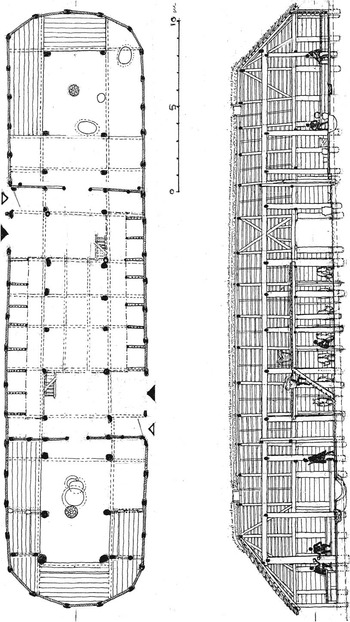
Fig. 8 Reconstruction drawings of a large long house from Legård, Thy showing both horizontal and vertical structure. The interior view gives an impression of the monumentality of the house and firepits in both ends indicate the existence of two habitation units (calculations and reconstruction drawing: Bente Draiby)
A direct parallel to the Legård house was recently excavated in Askov in south Jutland, together with one of the even larger long houses from the same period (Poulsen & Brønd Reference Poulsen and Brønd2008). The architectural regularity over large distances suggests that the internal division must reflect specific household organisation. One of us has previously proposed that it could be related to a dual or twin leadership in the Bronze Age (Kristiansen & Larsson Reference Kristiansen and Larsson2005, chapter 6.4).
The stalling of cattle suggests milk cows that had to be taken in for milking, just as the stall provided protection. Bulls/draft oxen and young calves were probably staying out during most of the year. Stalling, and thereby incorporation in the long house architecture, could also reflect the high value of these animals in the political economy.
The Legård house was mirrored in a slightly later long house building, constructed parallel to the old one, only a couple of metres away. It is noteworthy that this long house used smaller timbers, although of identical layout.
The timber construction used whole or cleaved tree trunks, with a few planks. As the base of the posts could be identified in some post-holes, the quantity of timbers and number of trees needed for construction can be calculated fairly accurately (Fig. 9). Bente Draiby concluded her analysis of the timber that four large logs of 70 cm diameter (at least 140–150 years old) were used for roof bearing posts; a further 12 and eight trees of c. 50 cm diameter were used for other roof bearing posts and wall planks respectively; 25 and 50 trees of 30 cm diameter for various other structural elements; and 50 trees of 20 cm diameter for the roof structures: all in all 150 oaks of various ages from 150 years down to c. 50 years old.
The ecology of the Bronze Age forests is difficult to estimate, in particular the age and size distributions of the tree populations are largely unknown. In modern unmanaged forests in Denmark oak constitutes a much smaller proportion of the species composition than they did in the Bronze Age. Still, the composition of oak consumption for the Legård house suggests that each house would have required at least a couple of hectares of optimally structured deciduous forest, and probably more, and the regeneration time would have been considerable, spanning several generations, with the large trees obviously constituting the greatest challenge, particularly if grazing was not controlled. Sustainable forest management would thus require significant areas of forest. If we assume the duration of the farm to have been 60 years, and the regeneration period of larger oaks a minimum of 150–180 years, it is immediately clear why high forest declined so rapidly, as evidenced in pollen diagrams (Fig. 10), and why timber was downsized in the next farm at Legård, although with the same dimensions (Reference Mikkelsen and KristiansenMikkelsen & Kristiansen in press for a discussion).
Construction would have demanded an experienced carpenter, who oversaw the whole construction process from selecting and cutting the logs into appropriate sizes to the actual building process. It would, in turn, have demanded a sizeable work force. It was a long-term undertaking, as the wood would need a drying period after being cleaved and cut into size. Transportation was another organisational demand, as forests were not available everywhere in Thy. This implies that control of the scarce forest resources could have been an important part of the political economy. The final construction phase was probably the shortest undertaking in the process.
The most timber-demanding part of the house was the horizontal plank wall, which was a special feature of large farms in Thy, whereas smaller farms employed wattle and daub that came to dominate from the Late Bronze Age for obvious reasons, as we shall see. In more densely forested regions plank wall construction was more common, but it is a general feature that wattle and daub dominates from the Late Bronze Age. Thus, the first generations of large Bronze Age long houses took their toll on the remaining forests in Thy, which were reduced so much, that high forests were effectively gone by the middle of the Bronze Age around 1300 bc (Fig. 10). Therefore, the adoption of wattle and daub walls can be seen as a necessary outcome of forest decimation in the early period of the Bronze Age. We should also see the dominance of stone cists over oak during periods II and III as being a result of this forest decimation, due to the demands on building timber in the densely settled Thy region.
The Bjerre Enge long houses
A low lying former seabed in north-west Thy close to the North Sea at Bjerre Enge was settled during the Middle and Late Bronze Age with a group of medium sized long houses, beginning in period II around 1400 bc and continuing until sand drift and a raised groundwater table finally led to the abandonment of the settlement towards the end of the Bronze Age around 800 bc, at the onset of the global climatic deterioration between 800–700 bc (Reference BechBech in press; Reference Søgård, Christensen and MortensenSøgård et al. in press). The sand cover, in combination with the high water table, created unique conditions of preservation for wood, bones, and household garbage (see Fig. 11).
Beach ridge formations and a temporal regression of the North Sea made the settling of the former seabed possible at a time where settlement density and resource exploitation in Thy was intensified during Montelius period II–III. Pollen analyses from the nearby lake Bjerre confirm the trends shown in Figure 10 (Reference Søgård, Christensen and MortensenSøgård et al. in press). High values of plantago in the lake pollen diagrams and from pollen samples under barrows support the picture of an extensively grassed landscape, just as the felling of alder around lakes and bogs suggests that all available resources were now exploited (Andersen Reference Andersen1995). Many species were used, including several that were not very suitable for firewood. Bog turfs were also used, so the situation was one of scarcity of suitable firewood (Reference MalmrosMalmros in press; Reference Henriksen, Robinson and KelertasHenriksen et al. in press).
Two long houses from Bjerre exemplify the much harsher ecological conditions that now prevailed (Bjerre 2 house III and Bjerre 6 house I). In both houses rather slight timbers were used for constructional purposes, even supplemented by fossil wood found during peat cutting (Bech & Olsen Reference Bech and Olsen2013; Reference MalmrosMalmros in press). Bjerre 2 house III was 6 m wide and 19 m long in its final phase, before it was abandoned. The house is presented in a reconstruction in Figure 13. It had no stall partitions, but evidence of household activities were concentrated in the western end of the house. A piece of amber in a post-hole suggests amber collection, which is also evidenced in the other house, Bjerre 6 house I, that had a small cache of raw amber hidden under the floor. Here lack of suitable building timber also resulted in the use of driftwood from the North Sea for building construction, and much of the other timber was from mixed tree species unsuited for house building (Fig. 12).

Fig. 12 Ground plan of house I from site 6 at Bjerre Enge, with the different tree species indicated by different colours (Wood identification by Christensen Reference Christensen1999; Reference MalmrosMalmros in press)
There was no availability of managed forests for this farm; we are thus far from the highly professional standards of forest management and timber selection evident in the Legård house. This observation may exemplify social and ecological differentiation, where some had access to the remaining forests in contrast to others. But even Legård was affected by a shortage of fully grown timber. Already the second generation of long houses at Legård showed downsizing of timber, and both here and in the common long houses at Bjerre, dried bog turves were used for burning in the hearths, along with twigs from, among other species, alder. This makes sense as alder grows in low, wet areas, which had to be cleared before bog turves could be dug. This is clearly an adaptation to a situation of timber shortage. The reduction of average long house size continues into the Late Bronze Age, where the largest long houses disappear. A standardisation of long houses into common long houses prevails, and in Thy and western Jutland, the economic decline may well have resulted in a decline or collapse of the political structure.
Life expectancy of long houses and a model for timber consumption
Based on the evidence of systematic field survey, in combination with numerous excavations, it is possible to reconstruct the Bronze Age settlement pattern with some certainty (Mikkelsen Reference Mikkelsen1996; Artursson Reference Artursson2009; Reference BechBech in press). The settlement pattern was based on single farms or hamlets evenly spread in the landscape and can be archaeologically exemplified by a local settlement unit at the Ås ridge in Thy (Fig. 14). It is characteristic of the densely settled landscape of the Bronze Age in Thy, and possibly large parts of Denmark, and thus corresponds well with the evidence from the pollen diagram in Figure 10. Based on this evidence it is possible to calculate the average number of farms per square kilometre within the settled areas. Some areas, such as Thy, would have 2–3 farms per km2, while others would have less. If we apply a conservative average of 1 farm per km2, and assume that half of the 44,000 km2 of Denmark were settled, we arrive at a contemporaneous number of 22,000 farms, that had to be rebuild at regular intervals. It has been debated how long a long house would stand before it needed replacement. Large, solid long houses have been estimated to stand for at least 2–3 generations, while smaller long houses would be replaced more often. However, we now have dendrochronological dates from preserved building timber in a few long houses in the Netherlands, and they indicate that some (larger) long houses stood for 60 years (Arnoldussen Reference Arnoldussen2008, 99ff). This specific long house shows repairs during its lifetime. However, most long houses show little evidence of repairs and replacements, which suggests that a life cycle of 30–40 years might apply. Some long houses, however, show an extension at one end which suggests that, throughout its lifetime a family, might be able to, or indeed needed, to expand. We may then hypothesise that the life cycle of a family group corresponded to the life cycle of the long house. When a new generation took over a new long house would be build. If we apply a 30 year life cycle then 22,000 long houses needed to be replaced 10–12 times during the 300–350 year long period of barrow construction. Around 240,000 long houses thus needed to be built within the period.

Fig. 14 Local settlement pattern at the Ås ridge in south-eastern Thy (after Mikkelsen Reference Mikkelsen2003). Squares: settlements; dots: barrows; dashed lines: hypothetical infield–outfield boundaries
The scale and ongoing character of this building programme meant that even relatively modest over-exploitation could have far reaching effects, at least within the most densely settled regions. It would decrease the forest size and thereby prolong the regeneration time. As oak needs 150–180 years to reach full size, and farms were renewed every 1–2 generations (30–40 years), it is easy to see that the reforestation could not keep pace with the timber consumption needed for constructing new long houses. This is what we see reflected in the pollen diagram from Thy (Fig. 10), with its steep decline of forests and the expansion of grasslands during Montelius period II–III.
Therefore, it is understandable that construction principles changed after 1300 bc, when long house sizes were generally reduced, and most farms now had wattle and daub walls. Thus, the use of plank walls was a rather short-lived phenomenon in Thy and in Jutland, as indicated by Figure 15. With a single, probably unreliable, exception large plank walled farms cease to be built shortly after 1300 bc.

Fig. 15 Radiocarbon dated horizontal plank walled houses from Jutland and their sizes (after Bech & Olsen Reference Bech and Olsen2013, fig. 3)
These adjustments to a situation of scarcity of good building timber from period III onwards are most clearly spelled out in Thy, as demonstrated above. Here there occurred a slight regeneration of forest during the Late Bronze Age, due to the timber saving adjustments in construction techniques. In other areas there was not the same scarcity of timber, but it is a general feature of pollen diagrams throughout south Scandinavia that, within the settled areas, the landscape generally became more open and more heavily grassed with less availability of solid building timber (Odgaard Reference Odgaard2006).
Living and dead during Montelius period II–III: the social demography of Early Bronze Age society
We argue that the average number of farms/households was 1 per km2 in the densely settled regions. One household/hamlet consisted of an extended family of at least 10 members. If we add various dependents, we may suggest an extended household of 15 people per km2 (Sørensen Reference Sørensen2010, table 5.3). If half of Denmark was settled with this density, that is 22,000 km2, it adds up to a population of 330,000 individuals. If we reduce the average size of households to 10 we end up with a population of c. 220,000 living individuals. That is a conservative figure. We estimated that to each farm unit corresponded a barrow, often several, as the total figure is 50,000 barrows. As each barrow would contain only a few burials it is clear that the majority of the population were not buried in the barrows. If we assume an average of five burials per barrow (based on well excavated barrows, but even then it is a rather high estimate), then 250,000 individuals were buried during a period of 350 years. That is c. 700 individuals per year. If we assume an average life expectancy of 35 years, then between 2.2 and 3.3 million people lived and died during Montelius period II–III (350 years long). The number of people receiving a burial in barrows would thus amount to c. 10% of the population. If we consider only the adult population, as children were rarely buried in barrows, we reach a figure around 20% at best. This relatively high frequency refers to the culmination of barrow building activity. Beyond this period the percentage would have been considerably lower.
In conclusion, barrows were the prerogative for a certain segment of the adult population, possibly the household leaders and possibly referring to kinship lineages. There appears to be a group of people who were not entitled to a burial in a barrow: the commoners. Thus competition for power and prestige as reflected in barrow building took place within a small segment of the population.
Conclusion: The Changing Balance of Ritual, Domestic and Political Economies
We have presented an analysis of resources tapped from the environment for barrow and long house construction during a rather brief period of 300–350 years in Denmark during the Middle Bronze Age, roughly 1500–1150 bc. We have used the extraordinary well documented excavations of a barrow (Skelhøj) and two settlements (Legård and Bjerre) as a model, which was calculated against the numbers of barrows recorded in the Danish Archaeological Sites and Monuments database for the period and an estimate of the total number of farms. It shows the explanatory potential of the monuments and site records, created during 150 years of archaeological surveys and excavations, when coupled with theoretical models, and contextualised information from well excavated barrows and settlements. We could demonstrate that the extraordinary construction activities during the period 1500–1150 bc supported ritual-cosmological and socio-political rationales, but occasionally on a local level that undermined the economic foundation of the household economies, most clearly in Thy.
To this we added a calculation of maximum and minimum population densities based on the number and the size of households in Denmark during period II–III, just as we calculated the number of people buried in barrows during the same period. Based on these figures we could conclude that only 10–20% of the adult population received a burial under a barrow. It seems to have been the prerogative of local household heads (male and female). We therefore suggest that the buried population represented the ‘free’ farmers, and that local chiefs were considered ‘first among equals’ to paraphrase a famous sentence from a Viking leader more than 2000 years later.
The picture presented also demonstrates differentiation between households during periods II and III, and a temporal sequence with a decreasing use of massive plank walls after period II of the Bronze Age, leading to a general decline of farm sizes with the onset of the Late Bronze Age. Or rather, the local construction of large timber consuming farmhouses came to an end, and was replaced by a diversification of functions into smaller houses. In the following paragraphs we shall probe a little deeper into the motivations and inherent contradictions of the observed strategies, and their long-term consequences.
The considerable investments in both monuments and house construction appear to be associated with an establishment of new social group identities and a formalisation of the relations between them. The general increase in house sizes suggests that one of the basic social groups, the household, on a general level was extended, and the architectural complexity of the houses could be an indication that this also involved diversification in the roles of the members of the household, as well as new forms of property, e.g. the stalling of cattle. The elaborate labour organisation in Skelhøj indicates that these entities took part in new forms of cooperation and, thereby, other social relations between groups were established and gradually formalised. The extension of these relations may also be recognised in the considerable increase in metal exchange occurring during this period. We must therefore assume that local and supra-local social and political relations were intimately connected. Participation in long-distance trade and alliances demanded surplus production and a capacity to organise travels, which had its base in the local economy. Therefore its organisation holds the key to also understanding the long-distance organisation of the metal trade (and also the products exchanged, which we do not discuss here).
The massive investment in the barrows is the most prominent evidence of the operation of these new groups and networks. The scale of the individual works, as well as the quantity, suggest that they were, in fact, one of the primary forums for the definition of the cooperative interaction of the groups. In part this must refer to a cosmological rationale with a considerable significance assigned to the burial and its rituals. On another level it may, however, also reflect some of the basic social properties of the barrow construction events. The observations at Skelhøj clearly indicate that the barrows constituted a gathering of groups of people, probably from different local households, within a strong religious framework and with a clearly defined constructional objective. Through the construction participants internalised a cooperative capability and demonstrated the potentials of the joint efforts. The successfully completed monument would stand as testimony to this, cementing the various roles and relations the participants had developed during construction as well as their reputation in general. Thereby, the barrows appear to have become a significant forum for the definition of some basic rules of the game for a new form of interaction, and the burial ritual itself would have been an occasion for alliance partners to meet and re-negotiate their relations. Although cooperative in scope this type of organisation also involved the contribution or sacrifice of farming land, as well as the feeding of many people – in short it involved both the domestic economy (feeding) and the relations between households (contribution of land and labour). As barrows were constructed of different sizes these relations were not balanced, and may in the long run have privileged some households/farms over others.
The large house structures may, in part, be seen as an equivalent. Archaeologically, the cooperation involved in their construction is more difficult to uncover than at the barrows, but in many respects it appears to have been on a level comparable to the one recognised in the barrows. The aspect of reputation and the practical development of cooperation are thus likely to apply to houses as well. After construction the houses evidently operated in a much more intense way than the barrows. They formed a basic physical framework for a substantial part of the everyday activities and thereby the definition of the new basic social group of the presumably larger household of the extended longhouses of the period. Again we note that there existed unequal access to resources (timber) and labour, which resulted in households of different size, structure, and wealth. It is therefore no coincidence that the largest houses with byres are horizontal plank wall structures which, again, demonstrate that control over one type of resource (timber) was linked to control over other types of resources (cattle).
At both the barrows and the long houses, it was, however, a costly form of interaction and group definition, involving a considerable consumption of time, land, and wood. The effects would have been immediately evident in the landscape, and the long-term consequences of a continued practice impossible to overlook. However, in a situation where group identities were new and the fragility of cooperation was apparent, this investment may have been required. It strengthened cooperation by staging the enactment of social relations in a ritual context. It also conveyed a reputation upon the participants in the construction and the individuals for whom the structure was erected, which in turn would facilitate trust in further cooperative endeavours. In this way, the monumental investments constituted a transformation of domestic resources to a form of social capital that re-enforced individual standing and power, locally and regionally. Still, the question remains, how this investment of domestic resources related to the rationale of domestic activities.
Our knowledge of the economy of the Early Bronze Age is, in many respects, fragmented. Reconstructions of the relative importance of agriculture and husbandry, the land-use patterns and landscape organisation within various regions, are largely hypothetical, with the exception of Thy (Reference BechBech et al. in press), Rogaland in south-western Norway (Prøsch-Danielsen & Simonsen Reference Prøsch-Danielsen and Simonsen2000), and the Ystad area in Scania (Berglund et al. Reference Berglund, Malmer and Persson1991). Still it seems substantiated that grasslands and heather were abundant and had been so since the Single Grave Culture in Jutland and since the Late Neolithic period in eastern Denmark. Probably these open landscapes were created for grazing purposes, and fields only took up a rather small part, though they were economically important in providing grain for bread and beer. Pollen diagrams in the most densely populated areas all speak of a relatively open landscape maintained by grazing animals, although central and western Jutland were more open than the hilly moraines of eastern Denmark. Here large forests still stood well into historical times, as hilly terrain was avoided by Bronze Age farmers, who were first and foremost looking for well drained soils, gently rolling hills, and plains. The coastal plains on the Danish islands were, therefore, focal centres for settlement during the Bronze Age. Their soils, once the forest was gone, were more easily worked and maintained for grazing. In Jutland the Thy region was the most densely settled, and richest in barrows. Here the pollen diagrams speak conclusively of a nearly treeless landscape, which is supported by the testimony from settlements and burials. While the oak coffin burial was the idiom in the main part of Jutland during the Early Bronze Age, in Thy it was replaced by the stone cist already by Montelius period II, and hearths inside houses were fuelled with dried bog turves, just as posts used in houses were scaled down in size.
The cultivated fields were probably closely associated with individual long houses. The same does not necessarily apply to grasslands and heaths. The extensive stretches of open land were not easily monitored and the grazing herds were mobile. Grazing thus required a form of collective adjustment, and it was particularly within this domain that the new group definition of monumental construction could have a heavy impact. It constituted a new basis for the negotiations of rights in the open land and principles of division of its production. The massive use of resources in itself implied a new mode of operating in the landscape. The investment in monument construction may thus be seen in relation to a particular attention paid to the grazing lands and their productivity during a redefinition of basic social groups and their relations. This attention appears to be echoed in the appearance of stalling in the long houses.
It is likely that the redefinition of rights in the landscape also involved a considerable competitive dimension, and that the barrows and long houses entered into this to demonstrate the capacity of local households as well as articulating claims to particular areas. This may have been one of the reasons that the emphasis on grazing land could occur at the expense of agricultural productivity. However, the intensive period of barrow and house construction also demonstrates that many local households participated, and that their internal relations were only gradually formalised. It seems that the barrow building events reflect the formation and definition of these groups and their rights to grazing land, which also defined their economic capacity for holding and stalling cattle. Apparently, this objective outweighed any recognisable negative effects of resource consumption, at least for some time. Once rights over resources were settled, so in all probability, were also the internal ranking of local households and their obligations towards each other.
The outburst of monumental energy was relatively short-lived. By the end of period III it had almost completely halted with regards to the erection of barrows. The largest of the long houses were no longer constructed, and during the ensuing centuries the average size gradually decreased. In some regions, particularly in Thy and western Jutland, the land remained open, and heaths continued to grow in size. Here resource consumption had a lasting impact on the economy and landscape organisation. In other regions the picture is less clear-cut. In the more loamy eastern parts, the landscape impact is less distinct, and there may have been an increased emphasis on cereals in some regions (Odgaard Reference Odgaard2006).
This development may be interpreted in different ways. It could be seen as the result of a collapse of an unsustainable practice. Several of the marked barrow groups of the Early Bronze Age appear to have become desolate areas in the Late Bronze Age, including the Tobøl-barrow group at Skelhøj, and, at least on a local level, the negative effects of resource consumption were comprehensive enough to justify interpretation of ecological collapse. Whether this interpretation also holds on an overall scale, is, however, a more complicated question. In western Jutland, deforestation created a significant problem, which the region subsequently had to struggle with for centuries. The spread of heath equally implied a gradual degradation of soil quality. To some extent this development, however, appears to be more of a shift in economic strategy with emphasis on large-scale extensive land exploitation. The development of heathland would, on an overall geographical level, continue in western Jutland through the Late Bronze Age and into the Iron Age. From this perspective, the decrease in the monumental construction can be taken as an indication that the emerging social groups and the principles of their interaction in the landscape had become more stable and resolved in the Late Bronze Age. In this situation, the construction of monuments lost its significance as reinforcement of the groups and their relations. The monuments took on a more passive role, but in many respects the consequences of the massive resource consumption remained both in terms of landscape transformations and in social organisation.
Epilogue
Throughout history, from megalithic constructions to medieval churches, runs a red thread of apparently irrational, ‘herostratic’ investments to achieve eternal fame and thus convert everyday matters of human exploitation and economic deprivation to eternal matters of salvation and fame. In this article we have outlined an economic model for the Early Bronze Age in Denmark, in which different rationales collided. The ritual and political goals obtained a dominating position which, on a local scale, was strong enough to undermine some of the domestic economical foundations upon which it rested. A new lasting landscape of monumental barrows and a more fleeting landscape of monumental long houses emerged. However, in the process, it led to local ecological collapse. The development involved both the development of cooperative relations as well as a competitive race for power and fame of a new, barrow building segment of the population. The competitive aspect entailed a self-reinforcing effect and the process was therefore unstoppable until it had fulfilled its purpose around 1150 bc. Through the construction of barrows and houses social relations were redefined and affirmed on a regular basis within ritualised and strongly organised frameworks. This consolidated the relations and thereby enabled extension and institutionalisation of the power of a select segment of the population. The specific historical processes behind the economy of Early Bronze Age Denmark that we have described thus contribute to our general understanding of the conditions pertaining for the rise of ruling elites, which Timothy Pauketat (Reference Pauketat2000), with reference to Hardin (Reference Hardin1968), appropriately termed ‘the tragedy of the commoners’. This apparent irrationality in investment relies on an imbalance between different economic rationales, and explains why such massive investments were often short-lived.
Appendix 1 : Calculating Barrow Intensity From The 3rd Millennium bc To The 1st Millennium ad
Early systematic and nationwide recording of the Danish barrows in the late 19th and early 20th century and the ensuing track record of their finds and excavations provide an unusually strong basis for an estimate of the intensity in the barrow construction over time (Table 1).
Table 1 Data used for the calculation of the relative barrow building frequency in the various chronological periods from 2850 bc to ad 1000. For further description see text.

The data set is today maintained in the Danish National Sites and Monuments Register (http://www.kulturarv.dk/fundogfortidsminder/) and, when the known megalithic barrows of the Neolithic Funnel Beaker Culture are omitted, more than 86,000 barrows remain. Of these approximately 22,000 are scheduled. The 86,000 barrows are the remains of a continuous or near-continuous period of barrow construction from the onset of the SGC at around 2850 bc to the end of the Viking Age at ad 1000. Dates of primary burials obtained by excavations over the last two centuries may provide a basis for calculation of the relative intensity in barrow construction over time.
The relative intensity is calculated as an index of the number of barrows with primary burials from a specific period divided by the duration of the period. The global maximum in the Early Bronze Age is set as index 100. The available archaeological evidence suggests a gap of several centuries between the megalithic Funnel Beaker Culture barrow tradition and the Single Grave Culture barrows, for which reason the initial barrow building frequency immediately before the SGC is set to 0. The same applies to the early medieval period after ad 1000.
This calculation ignores the indisputable problems of potentially varying representation of the recorded barrows of the different periods. There is clearly a variation in how distinctly recognisable and datable the burials of the various periods appear archaeologically, and differences in size, clustering tendencies, and location preferences topographically and regionally affect the degree of exposure to destruction. The relatively small barrows of the SGC would thus have been more prone to destruction before construction than the large barrows of the EBA, while the concentration of the SGC barrow tradition in historically extensively cultivated west Jutland, conversely, may have tended to establish an over-representation relative to the regionally more evenly distributed EBA barrows. Systematic source-critical analyses have demonstrated that, on a national level, the later intensification of agriculture in Jutland implies that here there is an over-representation of preserved Bronze Age barrows compared to the Danish islands (Baudou Reference Baudou1985). However, it can also be demonstrated that the number of excavated barrows is more or less equal on a regional and national level (Kristiansen Reference Kristiansen1985) and, as they number several thousand, we contend that the resulting graph presented in Figure 1 provides a valid impression of the relative intensity through time on a national level.
The records in the Danish National Sites and Monuments Register are not specific with respect to sub-periods. The information from the register has consequently been combined with more detailed published analyses of individual periods – for SGC (Hübner Reference Hübner2005), for LN (Lomborg Reference Lomborg1973; Vandkilde Reference Vandkilde1996) for EBA (Aner & Kersten Reference Aner and Kersten1973–2005), and for LBA (Broholm Reference Broholm1943–49). These studies of individual periods, however, vary considerably in methods and recording principles and are, as such, not comparable. Consequently, the Danish National Sites and Monuments Record is used for an estimation of the relative barrow building frequency between overall chronological periods, i.e. the Single Grave Culture, the Late Neolithic, the Early Bronze Age, the Late Bronze Age, the Early Iron Age and the Late Iron Age including the Viking Period. The individual period studies are used to specify the development within the periods.


