


In few areas of prehistoric archaeology in Europe, much fundamental progress has been made in recent years in the settlement archaeology of the Late Neolithic and the Early Bronze Age of central Germany, ie the period between (maximum) 2800 and 1550 bce. The mechanical removal of the plough horizon and the archaeological excavation of hundreds of hectares of land in the run-up to the extraction of raw materials (mainly lignite), the construction of new industrial areas, or the opening of up to 50 m wide corridors for large infrastructure projects, has led to the discovery of numerous settlement features of the Corded Ware, Bell Beaker, and Únětice cultures in Saxony, Saxony-Anhalt, and Thuringia. Pits, ditches, wells, and post-holes, some of which can be reconstructed into buildings, are the most common. Floor levels are only preserved in Central Europe in pre-alpine lake dwellings, but not in the dry mineral soils. Complete house inventories are therefore missing here, while tell sites are exceptional (eg Niederröblingen, Mansfeld-Südharz district; see Meller Reference Meller2011).
Intense ploughing over millennia has generally resulted in only deep ground interventions and their fillings having survived. Architectural structures that did not use posts or did not penetrate deep enough into the ground are archaeologically unidentifiable. Currently, there is still a lack of reliable information on the importance of buildings built on beam frames or on simple stone bases without deep foundations. Such structures could be assumed, for example, in those areas in which settlement pits and graves are present but where no post buildings are identified. Despite these difficulties, regularities in the post setting and an increasing number of radiocarbon datesFootnote 1 has allowed the identification of more than 240 Late Neolithic and Early Bronze Age building ground plans in central Germany, representing one of the largest systematic data sets in settlement archaeology of prehistoric Europe (Meller et al. Reference Meller, Friederich, Küßner, Stäuble and Risch2021). This evidence substantially broadens and modifies our understanding of Late Neolithic and Early Bronze Age societies, which has traditionally relied nearly exclusively on funerary remains and hoards.
The present study discusses the settlement dynamics and architecture of the Corded Ware, Bell Beaker, and Únětice groups with regard to the social, economic, and political changes taking place in central Germany over c. 1000 years, from approximately the mid-3rd to the mid-2nd millennium bce. During this period an exceptional increase in metal production and social asymmetries is observed, as suggested by the appearance of so-called ‘princely graves’, such as Leubingen, Helmsdorf and, most of all, the recently (rediscovered) Bornhöck (Meller Reference Meller2017; Reference Meller2019a). A new examination of the hoard finds and the patterns of their weapon composition suggest the existence of permanent armies linked to a central Únětice political entity (Meller Reference Meller2017; Reference Meller2019b). The production and centralisation of a substantial cereal surplus and its processing with special large and work demanding grinding tools, found in the stone cairn of the Bornhöck burial mound, confirms the existence of substantial population cohorts dependant on some kind of milling facility, probably under the supervision of a higher political authority (Risch et al. Reference Risch, Meller, Delgado-Raack, Schunke, Gimatzidis and Jung2021). In the light of new investigations, the Nebra Sky Disc, the first known calendar in Europe, becomes meaningful as an instrument of political and ideological legitimation of a centralised political entity or state (Meller & Michel Reference Meller and Michel2018). The development of Únětice settlements is a further key aspect in the rise of social asymmetries and economic exploitation, which can now be addressed from a spatial, topographic, and architectural perspective.
CORDED WARE BUILDINGS AND SETTLEMENTS (max. c. 2800–2200 bce)
Until the beginning of the 21st century, the Corded Ware culture in central Germany was mainly documented by hundreds of graves (eg Fischer Reference Fischer1956, 109–40), while hardly any information on settlements and economic organisation was available. Only the discovery of a complete trapezoidal ground plan at Gimritz, Saalekreis district allowed, for the first time, the recording of a certain type of building that has proven to be characteristic of Corded Ware settlements (Friederich & Jarecki Reference Friederich and Jarecki2014). In recent years it has been possible to assign 43 buildings with greater or lesser certainty to the Corded Ware culture (Fig. 1a). Other Corded Ware building types have been discussed repeatedly for central Germany but require a critical assessment (Höckner Reference Höckner1957).
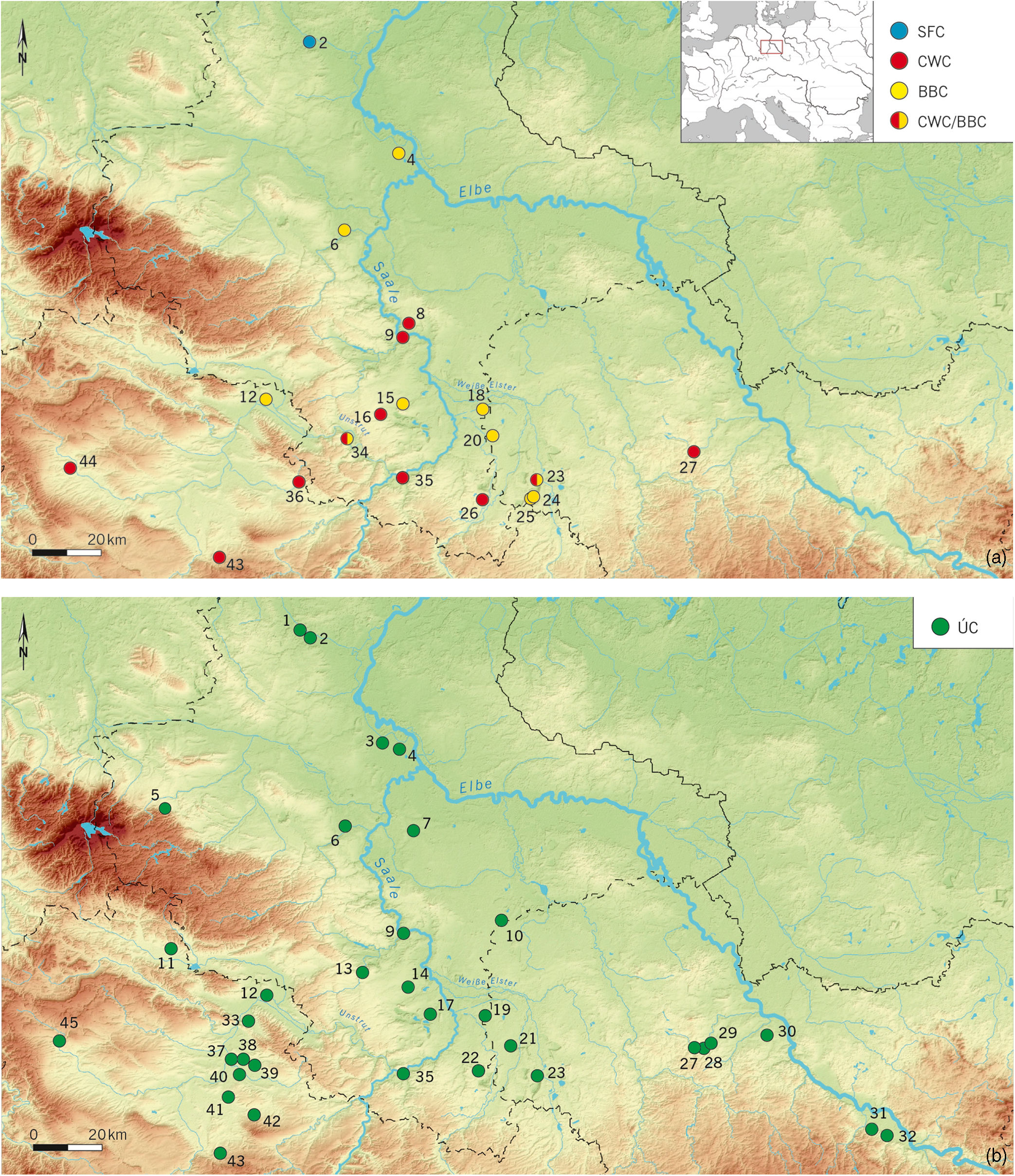
Fig. 1. Map of known Late Neolithic (a) and Early Bronze Age (b) buildings. 1) Haldensleben; 2) Wedringen; 3) Schönebeck; 4) Pömmelte; 5) Benzingerode; 6) Güsten; 7) Kleinpaschleben; 8) Gimritz; 9) Salzmünde; 10) Serbitz; 11) Urbach; 12) Artern; 13) Esperstedt; 14) Bad Lauchstädt; 15) Klobikau; 16) Oechlitz; 17) Beuna; 18) Günthersdorf; 19) Altranstädt; 20) Thronitz; 21) Zwenkau; 22) Bösau; 23) Kieritzsch; 24) Schleenhain (Breunsdorf); 25) Schleenhain (Großhermsdorf); 26) Profen; 27) Altmügeln; 28) Mügeln; 29) Schweta; 30) Prausitz; 31) Dresden-Kaitz; 32) Dresden-Nickern; 33) Heldrungen; 34) Wennungen; 35) Eulau; 36) Hardisleben; 37) Leubingen; 38) Dermsdorf; 39) Kölleda; 40) Frohndorf; 41) Schloßvippach; 42) Berlstedt; 43) Büßleben; 44) Höngeda; 45) Ammern
The geographical distribution of the Corded Ware building layouts known so far is limited to a relatively small area of about 300–1000 km2 in the south of Saxony-Anhalt and adjacent areas in Thuringia and Saxony (cf. Fig. 1a). East of this ‘core area’ a partially preserved building was excavated at Altmügeln, Nordsachsen district. The most westerly site is a ground plan on the upper Unstrut river near Höngeda, Unstrut-Hainich-Kreis district, whose orientation, dimensions, and closely set posts speak for a building of the Corded Ware culture, even though an Early Bronze Age dating is also quite possible (Winter & Walter Reference Winter and Walter2002). The comparison of the distribution of building ground plans and sites as a whole (Fig. 2a) illustrates a necessary criticism of the findings. Apparently, settlement finds, graves, and individual finds are over-represented compared to sites with building structures, as they are easier to detect. It is also probable that other building types existed but have not been detected so far.

Fig. 2. Late Neolithic and Early Bronze Age settlement finds and building plans in central Germany, in relation to climatic and edaphic conditions: (a) settlements and ground plans of the Corded Ware and Bell Beaker complexes; (b) settlements and ground plans of the Únětice complex
Corded Ware settlements are regularly located on a ridge or plateau, on an elevation, as well as on upper slope areas or above a valley floor, while they have so far been absent in low altitudes and floodplains (Friederich Reference Friederich2019, 22–3). Bodies of water can therefore be located up to several kilometres away from settlements. This also explains the frequent detection of wells or water extraction points, which, as in Gimritz, are often located on the edge of the settlements (Friederich & Jarecki Reference Friederich and Jarecki2019, 228–9, fig. 13; Stäuble & Friederich Reference Stäuble and Friederich2019).
The settlement sites recognised so far often only include single buildings. Yet, 19 buildings were excavated within the probably over 6 ha large settlement area of Gimritz, which could only be partially examined (Fig. 3). According to the nine completely preserved or at least reconstructable trapezoidal ground plans, the dimensions of these buildings are relatively uniform (Figs 4 & 5). While their lengths vary by 17.4 ± 1.9 m, the narrowest side is 6.1 ± 2 m and the opposing end 9 ± 1.6 m. Accordingly, the interior surfaces vary between 144.2 ± 31.6 m2. The interior building structure of the houses can be reconstructed on the basis of the post settings to rectangular areas of up to 40 m2, which may be an indication of intermediate floors with elevated living or storage areas. So far, however, there is little indication of the location of the entrances to these buildings. Only at Oechlitz building 1 can an access be detected on the western longitudinal side (cf. Fig. 4, 14). Similar, almost contemporaneous buildings are known from Haamstede-Brabers, Zeeland province, Netherlands (Hogestijn & Drenth Reference Hogestijn and Drenth2000, 135; Nobles Reference Nobles2014).

Fig. 3. Corded Ware settlement area of Gimritz, Saalekreis district, including houses, ovens, burials, and a well. Not all structures seem to have been contemporary, as can be observed in the eastern part of the excavation where ground plans overlap (Friederich & Jarecki Reference Friederich and Jarecki2019, fig. 13)
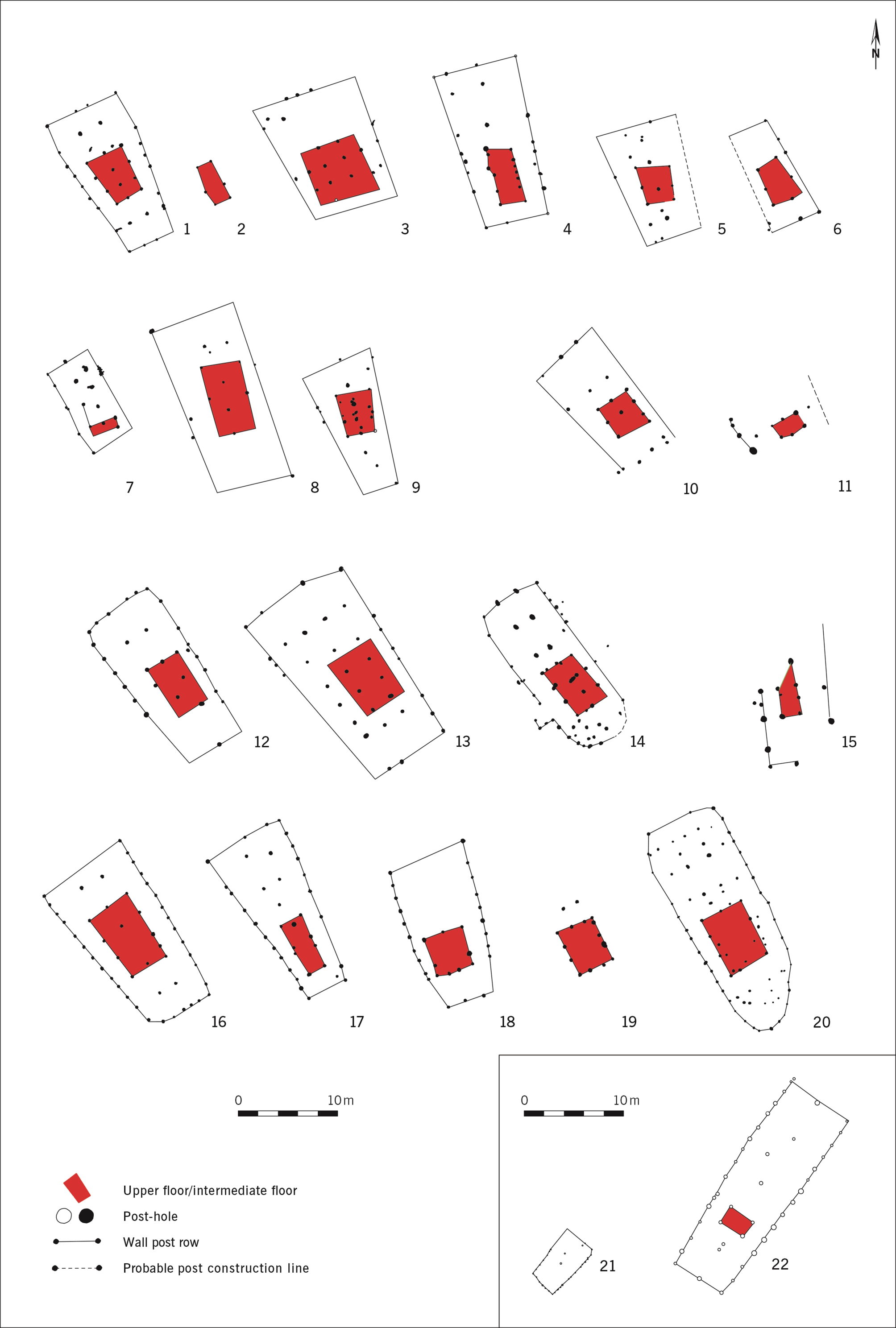
Fig. 4. Trapezoidal buildings with internal scaffold (Gimritz type) identified in Corded Ware settlements (modified after Friedrich 2019, fig. 3). (1–9) Gimritz: 1) house 1; 2) house 2; 3) house 4; 4) house 6; 5) house 13; 6) house 17; 7) house 23; 8) house 25; 9) house 26; (10–11): 10) house 1; 11) house 2; (12–13) Wennungen: 12) house 2; 13) house 4; (14) Oechlitz house 1; (15) Profen house 8; (16–19) Hardisleben: 16) house 1; 17) house 2; 18) house 3; 19) house 4; (20) Erfurt-Büßleben house 2 (feature 565); (21) Mienakker, Netherlands; (22) Zeewijk-Ost, Netherlands
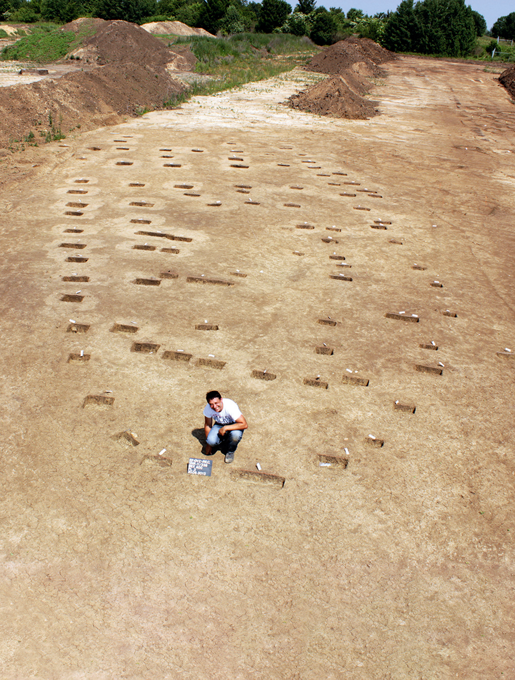
Fig. 5. Corded Ware building 3 of Erfurt-Büßleben, district Erfurt, during its excavation (Scech Reference Scech2019, fig. 3a; photograph: C. Zühlsdorff, TLDA)
The trapezoidal, Corded Ware buildings of the Gimritz type have a very uniform orientationFootnote 2 of 332 ± 10º, with the shortest narrow side always in the south-east and the entrance possibly in the north-west. The incomplete buildings with more or less parallel walls also show a uniform value of –29 ± 17º, which corresponds to a house orientation of 331 ± 17º or 151 ± 17º, depending on whether the narrower side is in the south-east, as is usually observed, or in the north-west. So far we know of only two trapezoidal buildings which, with an orientation of 148º, almost exactly correspond with the latter orientation.Footnote 3 Within the central German distribution area, the uniform orientation of the Corded Ware buildings is therefore notable (cf. Figs 4 & 5).
In addition to the trapezoidal buildings, settlement pits, and wells, oven pits which may have been used to preserve meat or dry grain are also an indication of settlement areas of the Corded Ware. To date, more than 125 such ovens are known from an area spanning about 150 km between the eastern Harz foothills to the Elbe river (Balfanz et al. Reference Balfanz, Kleinecke, Dalidowski, Pscheidl and Friederich2019). These are pear- or hourglass-shaped structures or two adjacent pits up to 5 m long, 3 m wide, and 1.5 m deep (Fig. 6). High temperatures have led to a slight vitrification of the pit walls. These findings are usually located on the periphery of Corded Ware settlement areas and date mainly to the period 2900–2500 bce, ie to the older phase of the Corded Ware culture – although a connection with the Globular Amphora culture or the Bernburg culture cannot be completely ruled out. Most of these oven pits are empty or contain few finds. So far, none of these structures has been found near trapezoidal building types which may be due to their different dates (see below).

Fig. 6. Oven structure from Gimritz, Saalekreis district (Balfanz et al. Reference Balfanz, Kleinecke, Dalidowski, Pscheidl and Friederich2019, fig. 4a; photograph: K. Bentele)
BELL BEAKER BUILDINGS AND SETTLEMENTS (c. 2500–2200/2050 bce)
The archaeologically verifiable buildings of the Bell Beaker complex were first recognised during the large-scale excavation at Klobikau, Saalekreis district (Balfanz et al. Reference Balfanz, Fröhlich, Schunke, Meller, Arz, Jung and Risch2015). In this relatively short-lived settlement area at least three building ground plans could be recorded amongst nine concentrations of posts (Figs 7 & 8, buildings GGR1–3). Radiometric results and finds from 50 settlement pits confirm the cultural attribution of the c. 9 ha settlement (Fröhlich Reference Fröhlich2019). At present, 21 more or less complete building ground plans exist in central Germany. Beyond central Germany, such boat-shaped ground plans in association with Bell Beaker finds have also become known from Walpersdorf, St Pölten-Land district, Austria (Morschhauser Reference Morschhauser2015; Kern et al. Reference Kern, Penz and SChmitsberger2019). They also correspond in size and orientation to the buildings from Klobikau, which might indicate a closer connection between the communities of Lower Austria and central Germany (cf. Figs 8–10).

Fig. 7. Bell Beaker settlement area of Klobikau, Saalekreis district. At least three buildings and several pits can be identified (Fröhlich Reference Fröhlich2019, Abb. 3a)

Fig. 8. Slightly trapezoidal or boat-shaped buildings associated with Bell Beaker pottery. 1–2) Klobikau houses GGR1 & 2; 3–4) Güsten house 1 & 2; 5–7) Schleenhain houses 1, 3 & 4; 8) Kieritzsch house 8 (modified after Fröhlich Reference Fröhlich2019, figs 6 & 9); 9–10) Walpersdorf houses 2 & 3 (modified after Kern et al. Reference Kern, Penz and SChmitsberger2019, 185, fig. 10.6)

Fig. 9. Box plot comparing the size (m2) of Corded Ware and Bell Beaker buildings

Fig. 10. Únětice settlement of Schloßvippach, Sömmerda district. Thirteen buildings, graves, pathways, pits, wells, and other auxiliary structures have been identified (Küßner & Walter Reference Küßner and Walter2019, fig. 15)
The area in which buildings of the Bell Beaker complex have been documented so far is larger than that of the Corded Ware buildings (cf. Fig. 1a). Above all, the settlements with long buildings seem to have spread northwards along the Saale to Pömmelte-Zackmünde, Salzlandkreis district, on the middle Elbe, where the completely excavated ring sanctuary marks the northernmost point of the Bell Beaker diffusion (Spatzier Reference Spatzier2017; Reference Spatzier2019).
The eight settlement sites of the Bell Beaker horizon with boat-shaped buildings known so far are located on plateaus as well as on the plain and in floodplains (cf. Figs 1a & 2). In contrast to the dwelling places of the Corded Ware settlements, which are mostly situated at higher altitudes and away from watercourses, this geographical location indicates a stronger agricultural orientation. Likewise, there is little evidence so far for wells in the vicinity of settlement features with Bell Beaker finds (eg, Kretschmer & Herbig Reference Kretschmer and Herbig2019, 343; Stäuble & Friederich Reference Stäuble and Friederich2019, 493). On the other hand, the number of pits in Bell Beaker areas is significantly higher than in Corded Ware settlements (ratio c. 4:1; Conrad Reference Conrad2019, 114). Since their cylindrical, funnel-shaped, and truncated cone-shaped profiles suggest a function as storage pits, this can be taken as further evidence for the agricultural orientation of the Bell Beaker communities. The more frequent occurrence of grinding stones and, especially, loomweights also suggests the importance of agricultural production (eg, Conrad Reference Conrad2019, 122; Kretschmer & Herbig Reference Kretschmer and Herbig2019, 344).
The buildings and settlement pits of the Bell Beaker complex appear to be scattered over wide areas so that, in many cases, one may assume individual farmsteads or hamlets. For example, Klobikau, extends over a total length of about 1 km. Additionally, the contemporaneous graves are often located at a great distance from the houses or pits. As with the Corded Ware settlements there is no evidence of defensive measures or strategic positioning.
The buildings of the Bell Beaker complex are mainly characterised by a greater variability in the positioning of posts (cf. Fig. 8). They tend to be slightly trapezoidal or even boat-shaped. The known buildings have an average length of 16.5 ± 3.9 m, a minimum width of 4.1 ± 0.6 m, and a maximum width of 6.5 ± 0.9 m. Thus, they do not differ from the Corded Ware buildings in length, but considerably in width, which is 1.9–2.5 m less. While the Corded Ware buildings have a floor area of over 120 m2, the Bell Beaker buildings are mostly below this value – but with considerably greater variations (Fig. 9), as evidenced by the ‘outlier’ building GGR1 from Klobikau with its floor area of 175 m2 (cf. Figs 7 & 8, 1). Whether these differences in size are functional (eg, integrated stable) or rather socially determined must remain open for the time being in the absence of a detailed study of the settlement finds.
The 17 boat-shaped ground plans show a rectified orientation of 129 ± 16.4º, which clearly differs from that of the Corded Ware buildings. Only building 33 from Pömmelte-Zackmünde, with 170º, falls out of both the Bell Beaker and the Corded Ware patterns. The incomplete ground plans of Kieritzsch building 7 and Thronitz, Leipzig district, building 1 are slightly below or above the typical orientation of most Bell Beaker buildings of c. 130º. None of them, however, has a characteristic trapezoidal or boat-shaped ground plan, but rather a rectangular design that became prevalent in the Únětice period. It is possible that these structures were built around 2300 bce at the transition from the Bell Beaker to the Únětice period.Footnote 4
ÚNĚTICE BUILDINGS AND SETTLEMENTS (c. 2200–1550 bce)
In the 1950s, in Bohemia, for the first time the ground plans of longhouses were recorded, which are now considered to be the characteristic, or at least the archaeologically verifiable, buildings of the Central European Únětice culture. After the first evidence was found in the excavations at Postoloprty, okr. Louny, Czech Republic, about 4 km further east in Březno, okr. Louny, Czech Republic, the first complete house ground plans were documented (Soudský Reference Soudský1953; Pleinerová Reference Pleinerová1992; Ernée et al. Reference Ernée, Dobeš, Langová and Limburský2019). Ground plan No. 100 from Březno, with a length of 32 m, width of 6.5 m, and area of c. 210 m2, was later defined as a typical Early Bronze Age longhouse (Schefzik Reference Schefzik2001).
Up to the beginning of 2019, 701 sites of the Únětice culture had been recorded in Thuringia, including 261 settlement sites and 219 areas with graves or grave groups (Küßner & Walter Reference Küßner and Walter2019). At the same time, in Saxony 256 sites were known (Conrad Reference Conrad2019, 113), although this number also includes graves with no connections to settlements. In Saxony-Anhalt, at least 1098 findspots with Únětice settlements, graves, and single finds have been recorded (Evers Reference Evers2012). With the beginning of the Únětice culture around c. 2200 bce, the settlement area defined by longhouses expanded again (cf. Fig. 1b). The Thuringian Basin, the central and northern Saxon areas along the Elbe, and the region along the lower Saale, show intensive settlement as do the areas in southern Saxony-Anhalt and the Leipzig lowlands.
Until 2019, extensive excavations provided evidence for the remains of 178 buildings in 34 settlement sites (cf. Fig. 1b). In comparison with the entire settlement area of the Circum-Harz group of the Únětice culture, the distribution of these ground plans does not show any significant differences or groupings (cf. Fig. 2b). It can therefore be assumed that the same buildings were represented in the entire Únětice area. It is possible to infer from this that an ‘ordinary’ Únětice settlement consisted on average of about five long buildings. Large-scale excavations over several hundred hectares, such as at Salzmünde, Saalekreis district, Eulau, Burgenlandkreis district, Kieritzsch, distict of Leipzig or Bad Lauchstädt, Saalekreis district, have shown that groups of 2–5 longhouses were laid out at distances of a few hundred metres from each other (Ganslmeier Reference Ganslmeier2019, 327, fig. 3; Kretschmer & Herbig Reference Kretschmer and Herbig2019; Schunke Reference Schunke2019), although not all might have existed at the same time.Footnote 5
Single farmsteads and hamlets characterised extensive settlement landscapes such as at Zwenkau, Leipzig district, where 39 long buildings could be documented in an excavated area of about 250 ha (Stäuble Reference Stäuble2019) and Leubingen (Küßner & Welcher Reference Küßner and Wechler2019, 436–9). Instead, Schloßvippach, Sömmerda district, provides insight into the spatial organisation and architecture of a small Únětice village, which was excavated in its entirety (Fig. 10). At least 13 buildings were constructed over a few centuries, though not all were contemporaneous. According to the radiocarbon dates of the burials located mainly in a well defined small cemetery in the north-eastern part of the settlement, the main occupation phase spanned the 21st–20th centuries bce (Walter et al. Reference Walter, Endrigkeit, Bartel, Schneider, Mecking and Ettel2019, 422). The variety of houses suggests a combination of uses and activities, as is also indicated by a semicircular space, delimited by 12 posts in the centre of the settlement (Fig. 10). Other settlement structures were storage pits, water basins, and wells. In the southern part of the settlement, remains of the substructure of a pathway were found which once consisted of wooden planks (Küßner & Walter Reference Küßner and Walter2019, 49–52).
The current excavations around the ring sanctuary of Pömmelte-Zackmünde, district Salzlandkreis, show that also substantially larger settlements existed (Fig. 11). This ditched enclosure is located in a particularly fertile stretch of the middle Elbe valley, 2 km south of the present-day course of the meandering river. It was delimited by a series of concentric palisades and ditches, the outer of which measures 115 m in diameter (Spatzier Reference Spatzier2017). According to the radiocarbon dates and pottery typology the circular sanctuary was founded in the Bell Beaker period but continued developing during early Únětice (c. 2300–2050 bce). A large settlement extended over a north-west to south-east stretch next to the rondel and comprised dozens of close and approximately parallel standing buildings (Jurkènas & Spatzier Reference Jurkènas and Spatzier2019; Meller & Zirm Reference Meller and Zirm2019). Ongoing excavations have uncovered settlement remains and burials over an area of 15 ha. So far, at least 100 Únětice longhouses have been identified among the different post-hole alignments. Even if not all buildings were contemporaneous, such extensions testify the existence of substantial population aggregates. The number of grinding stones found in the remains of the previously mentioned Bornhöck ‘princely’ burial mound, also point to the existence of substantial population concentration (Risch et al. Reference Risch, Meller, Delgado-Raack, Schunke, Gimatzidis and Jung2021).

Fig. 11. Bell Beaker and Únětice circular enclusure and settlement of Pömmelte, Salzlandkreis district, on the middle Elbe. The plan includes the excavatons carried out up to 2019 (Meller & Zirm Reference Meller and Zirm2019, fig. 1)
In addition to longhouses and various settlement pits, in some Únětice settlements wells, water pits, or scoop holes have also been documented, which underlines the importance of choosing locations with easy access to groundwater (Küßner & Walter Reference Küßner and Walter2019; Schunke Reference Schunke2019; Küßner et al. Reference Küßner, Schunke and Walter2021). In Brehna, Anhalt-Bitterfeld district, an almost circular, 0.5 m deep pit with traces of intense burning has been found. In addition to the bones of a man and a child, the backfill consisted of lumps of clay and fragments of misfired wasters indicating a potter’s kiln (Schunke Reference Schunke2019, 131–2). Activity areas have also been found in particularly favourable locations. Thus, in a natural depression at Salzmünde-Schiepzig, Schiepzig subdistrict (Saalekreis district), an oval area 45 m long and 30 m wide has been preserved between four buildings. This appears to have been paved with fist-sized stones that had been brought in from elsewhere (Moser & von Rauchhaupt Reference Moser and von Rauchhaupt2019). Between and on top of the stones lay thousands of animal bones and hundreds of coarse stone tools and flint artefacts. It is possible that this was a place for slaughtering and processing animals, especially cattle. A very similar range of finds is also known from several pits in Gotha-Sundhausen (Tannhäuser Reference Tannhäuser2019). In addition to slaughtering remains, also tempering material (mica) for pottery was found there, while a ceramic nozzle indicates metalworking. These diverse types of features, which were only preserved under favourable circumstances, show the architectural and economic complexity of Únětice settlements.
Locaton of the Únětice longhouses
It has repeatedly been pointed out that the Únětice settlements were preferentially situated near rivers and high quality soils.Footnote 6 They were mostly located in the area of low-lying and thus warmer river valleys such as those of the Gera, Unstrut, Weiße Elster and their respective tributaries, which as individual subregions had the longest vegetation periods and the lowest precipitation. Thus, the central Thuringian Basin, the Erfurt Basin, northern Thuringia, the Leipzig Bay, or the lowland plain of the Elbe in the Salzlandkreis district were particularly densely populated landscapes, while surrounding areas with higher precipitation tended to be avoided (cf. Fig. 2b). In view of the scattered location of buildings and settlement pits, but also of graves and small burial groups (Hubensack Reference Hubensack2018), the landscape of the Únětice period must have been characterised by a scattered but relatively dense settlement, especially along watercourses.
The Únětice settlers – even more strictly than those of the Final Neolithic –favoured access to soils with the highest agricultural yield potential (cf. Fig. 2a & b). These are easily cultivated black earths (chernozem) or degraded black earths on loess (Küßner & Walter Reference Küßner and Walter2019, 50; Meller Reference Meller2019a, 247, fig. 1). Sandy loams and clayey-sandy Keuper and Zechstein weathered soils as well as rendzinas on shell limestone were also of importance. In Thuringia, on the other hand, it could be shown that deep loam and clay soils that were difficult to plough, pure sandy soils, and all waterlogged soils were avoided (Küßner & Walter Reference Küßner and Walter2019, 50). This spatial relationship to particularly fertile soils also partly explains the paucity of settlements in the Elbe valley between Meißen and Pömmelte-Zackmünde or the absence of settlements on red sandstone areas such as the east Thuringian variegated sandstone plateau and on crystalline substrates on the flanks of the Thuringian Forest, the Thuringian Highland (Thüringer Schiefergebirge), and the Rhön mountains (cf. Figs 1b & 2b; Küßner & Walter Reference Küßner and Walter2019, 50). Hilltop settlements and easily fortified positions were again not important for the Únětice settlements (Ettel Reference Ettel2010; Ettel & Schmidt Reference Ettel and Schmidt2010–11).
Type and size of the Únětice buildings
As mentioned above, ground plans can only be recognised archaeologically where posts have been sunk deeper than c. 0.3–0.6 m into the ground, as this corresponds to the depth of the surface disturbed over the last millennia mainly by agricultural cultivation. The most frequently attested post construction of the Únětice settlements in central Germany and Bohemia is the Březno-type longhouse, which is often also referred to as the Zwenkau type in German-language literature (Schunke & Stäuble Reference Schunke and Stäuble2019). Its distinguishing features have been defined as follows (Ernée et al. Reference Ernée, Dobeš, Langová and Limburský2019, 785):
-
more or less west–east oriented, elongated, mostly two-aisled buildings;
-
sidewalls made of tightly set posts;
-
more loosely set posts of the middle row;
-
absence of eastern gable wall;
-
frequent pairs of posts in the western part oriented at right-angles to the longitudinal axis, which can also be addressed as a T-shaped post setting;
-
missing corner posts on the west wall, resulting in a slightly apse-like rear wall;
-
entrance located approximately in the middle of the south wall;
-
possible marking of the entrance by recessed interior posts (three-post setting).
In addition, in some cases a slight offset of the eastern corner posts can be observed (Fig. 12). In rare cases, the western narrow side may also have an apsidal shape. The average distance between the posts varies between 0.5 m and 1.2 m for the exterior walls. However, some buildings, including the large building 1 of Dermsdorf, Sömmerda district, stand out due to their particularly tight post settings (Küßner & Wechler Reference Küßner and Wechler2019; see Fig. 19, below).

Fig. 12. Ground plans of the four variants observed among the Únětice longhouses of type Březno and of the Nordic house type (modified after Meller et al. Reference Meller, Friederich, Küßner, Stäuble and Risch2021, 197, 67, 190, 200, 97, 257, 212, 255, 183, 80, 153, 238). 1) Pömmelte house 11; 2) Kieritzsch house 3; 3) Pömmelte house 1; 4) Pömmelte house 17; 5) Zwenkau house ZW_27; 6) Schloßvippach house 12; 7) Salzmuünde-Schiepzig, subdistrict Schiepzig, house SZ_01; 8) Schloßvippach house 6; 9) Kleinpaschleben-South house KP_01; 10) Schweta house SWQ_02; 11) Benzingerode house BR_01; 12) Artern house 2a

Fig. 13. Spatial distribution of Únětice culture building types and variants of central Germany. In settlements with several building types, the top circle marks the most frequent variant, the lowest the least frequent one. Settlement numbers according to Fig. 1b

Fig. 14. Buildings KP1, KP2, and KP3 of the Únětice settlement of Kleinpaschleben-South. The ground plan of building 3 overlaps with that of the large building 2 and is hardly visible in this air photography (Schunke Reference Schunke2019, fig. 55)
The entrances to the buildings, insofar as they can be deduced from the post setting, are in many cases located in the eaves of the southern longitudinal walls, more-or-less in the middle (Walter et al. Reference Walter, Endrigkeit, Bartel, Schneider, Mecking and Ettel2019, 427–8). The absence of post-pits on the eastern, narrow sides is an indication that additional means of access existed here (Fig. 12).
The most distinguishing features within the group of longhouses of the Březno/Zwenkau type are the interior posts. Above all, the differentiated post settings (compared to the eastern part) in the western part of the buildings indicate different roof constructions or interior designs. Double or even triple rows of posts suggest an intermediate floor in the western part which could, for example, point to an elevated storage room. The large building 1 of Dermsdorf (Küßner & Wechler Reference Küßner and Wechler2019), like some other houses (Schunke & Stäuble Reference Schunke and Stäuble2019, 400), is built with three aisles throughout, which would have allowed the installation of an upper storey (Fig. 12, 9–10). In the case of Dermsdorf, an upper storey would have increased the usable area of the building (floor area c. 488 m2) by at least 50% and would have offered extraordinary storage potential.
Based on the different post settings in the interior and especially in the western part of the buildings, three different variants of the Březno/Zwenkau type could be defined (Schunke & Stäuble Reference Schunke and Stäuble2019). In addition, there are two-aisled buildings without a truss, the so-called Nordic building type (Schunke & Stäuble Reference Schunke and Stäuble2019; Küßner et al. Reference Küßner, Schunke and Walter2021), and small or ancillary buildings (Ganslmeier Reference Ganslmeier2019). Thus, all in all, the following six building types can be distinguished for the central German Únětice area among the house ground plans documented up to 2019 (Fig. 12; Meller et al. Reference Meller, Friederich, Küßner, Stäuble and Risch2021):
-
1. Variant without a truss: six ground plans belong to buildings with central ridge posts, but without a truss.
-
2. Pömmelte variant: With 42 ground plans, this is the most frequent building variant of this type so far. In the two-aisled interior there is a single truss near the western end. The function of this double post setting is unknown. A special roof construction such as an opening for the smoke outlet would be conceivable.
-
3. Salzmünde variant: In the western part of the building there are two trusses, generally of the same size, which stand at a considerable distance from each other. This resulted in a more-or-less large three-aisled room. In some cases, this area extends to the entrance in the south wall, dividing the buildings into an architecturally clearly distinguishable west and east part. As already indicated, this construction method suggests an intermediate floor for an additional room – eg, for storing grain. So far 22 ground plans can be assigned to this variant.
-
4. Kleinpaschleben variant: 18 ground plans have an uninterrupted three-aisled interior space in which ridge posts are mostly missing. The large number of trusses also suggests a raised storage or living area.
-
5. Nordic building type: In addition to the Březno/Zwenkau type, buildings with an apsidal west side and a central ridge line, but without a truss, are also found in the central German area of the Únětice culture (eg, Benzingerode building BR_02; Artern building 2a; Schönebeck-Felgeleben building 5). Given their similarity to the Late Neolithic buildings of northern Germany and Scandinavia, they have been addressed as a ‘Nordic building type’ (Artursson Reference Artursson2009; Schunke & Stäuble Reference Schunke and Stäuble2019, 407, fig. 9; Küßner et al. Reference Küßner, Schunke and Walter2021, 39, fig. 5). Another distinctive feature of some ground plans of this building type are pits up to 0.6 m in diameter in which the ridge posts stood (eg, Benzingerode building BR_01 and BR_02). With only nine ground plans currently assigned to this type with more-or-less certainty, this is undoubtedly an architectural abnormality in the Circum-Harz area of the Únětice culture. Building 2 from Wedringen, Börde district, with its apsidal ends on both the western and the eastern side, is unique, but shows a very irregular post setting for the Únětice culture and cannot be dated with certainty to the Early Bronze Age.Footnote 7
-
6. Small or ancillary buildings.
Since the larger settlements or settlement areas (eg, Zwenkau) can have buildings of both types and all four variants, it is reasonable to assume that the architectural design of the house interiors reflects functional and/or social differences. This seems to be the case especially with the Kleinpaschleben variant with its presumably continuous intermediate floor, which occurs throughout most of the region (Figs 13 & 14). The few buildings of the Nordic type also seem to occur sporadically throughout central Germany. However, geographical and chronological differences may also have played a role (Schunke & Stäuble Reference Schunke and Stäuble2019, 413–4). It is noticeable, for example, that buildings of the Pömmelte variant and buildings without a truss are mainly found along the Elbe and in the surrounding areas, whereas they have so far been absent in the Saale-Unstrut region and in Thuringia (Fig. 13). Here, on the other hand, most of the buildings of the Salzmünde variant are found, which is very rare along the Elbe. Since both variants existed at the same time (see below), a regional differentiation is indicated, which can be further substantiated.
The Únětice buildings known to date vary from 2.5 m to almost 57 m in length and 1.6–10.9 m in width. While the mean length is 22.3 ± 9.5 m, their widths are about 6.2 ± 1.2 m. The comparison of both measurements (Figs 15–17) confirms that, despite a clustering of values at 18.0–25.0 m, the house lengths turn out to be far more variable than the widths. The distribution of lengths (Fig. 15) indicates three different classes of buildings. In addition to the typical longhouses, a second category of smaller, rectangular buildings with a maximum length of about 2.5–6.0 m were apparently erected (Fig. 18). Whether these were storage buildings, workshops, or ancillary buildings remains to be clarified in future excavations. Moreover, it cannot be ruled out that these eight buildings identified so far are only incomplete longhouses, where the posts were set lower in a certain area and have only there been preserved as archaeological features. Excluding the small buildings, the mean dimensions of the long buildings are 24.0 ± 8.1 m (length) and 6.4 ± 0.9 m (width). However, building 26 from Zwenkau clearly deviates from the mean value with a length of 56.6 m and indicates a third category of particularly large buildings (Fig. 19).

Fig. 15. Number of Únětice buildings in central Germany according to their length

Fig. 16. Number of Únětice buildings in central Germany according to their width

Fig. 17. Length and width of the probably completely preserved Únětice ground plans from central Germany (N = 94): Squares: small or auxiliary buildings; circles: longhouses; diamonds: large buildings

Fig. 18. Possible Únětice ancillary buildings (modified after Meller et al. Reference Meller, Friederich, Küßner, Stäuble and Risch2021, 258, 253, 165, 161, 164, 215, 216)

Fig. 19. Known Únětice large buildings (modified after Meller et al. Reference Meller, Friederich, Küßner, Stäuble and Risch2021, 96, 243, 73, 75)
The varying length of the buildings could be understood as an indication of the size and/or wealth of the household. Functional differences cannot be ruled out either. The almost 100 complete ground plans confirm the three building classes, based on the ratio between length and width (Fig. 17). Apart from the small, more-or-less rectangular structures of unknown function (Fig. 18) and the long buildings, which are similar in width, four buildings stand out because of their enormous length and especially width (Fig. 19). The construction of these large buildings, with floor areas between c. 360 m2 and 500 m2, required extraordinary amounts of raw materials, the coordination of labour and knowledge. Although there are only a few clues as to their function so far, they must have been monumental structures that were certainly directly related to the Únětice ruling class. For example, the large building 1 from Dermsdorf is interpreted as the possible lodgings of a warrior community in stately service (eg, Meller Reference Meller2013, 520–1; Reference Meller2017; Reference Meller2019a or Reference Meller2019b) due to the find of a vessel containing two halberd blade blanks and 98 bronze axes (Küßner & Wechler Reference Küßner and Wechler2019). On the other hand, the building with the hoard has been interpreted ‘as a combination of cultic-religious function, assembly and representation building as well as housing for the elite or single ones of these functions’ (Küßner Reference Küßner2015, 197).Footnote 8 In view of the fact that occupation layers have practically not been preserved, only the examination of finds from the post-holes and pits belonging to the structures can provide more detailed information on original activities. Grinding stones and other stone tools, loomweights, storage vessels, and animal bones are among the common finds in and around the buildings, however, the documentation is still too sparse and unsystematic to accept uncritically the conventional interpretation of the long buildings as dwelling houses of large families.
If the lengths and widths of the four main building variants are displayed in a scatter plot, no clear patterns emerge (Fig. 20), apart from the fact that the two largest ground plans known so far in central Germany belong to the Kleinpaschleben variant (Dermsdorf building 1 and Zwenkau building ZW_26; Fig. 19). All building variants show a similar range in their length (cf. Fig. 20). Also the Nordic building type cannot be differentiated from the usual longhouses. Only the very few simple, two-aisled buildings without a truss do not exceed 27 m in length. Apparently, this is a group of architecturally less elaborate buildings. Considering their length, ground plans of the Salzmünde variant with two trusses in the western part are narrower than the rest of the variants. The two-sample t-test of the length-to-width ratio between the Pömmelte variant and the Salzmünde variant confirms that this difference is significant.Footnote 9 Thus, there is further quantitative evidence that the architectural variant Salzmünde was designed differently and perhaps had a different function to the other building variants.

Fig. 20. Size of different Únětice building types and variants: bars: buildings without truss; circles: Pömmelte variant; triangles: Salzmünde variant; squares: Kleinpaschleben variant; diamonds: Nordic type
Orientation of the Únětice buildings
The longhouses and large buildings of the Únětice settlements and hamlets follow an orientation that is clearly different from that of both the Bell Beaker and the Corded Ware buildings. While in the latter two cases the wider or open narrow sides point to the south-east and north-north-west, respectively, the Únětice buildings of the Middle Elbe-Saale region are preferentially aligned along the west–east axis, with the narrow side, closed off by posts and apsidal in appearance, always in the west (x¯ = 87.8 ± 17.7º). The orientations of the different building types and variants are similar, whereby specific features can be observed in each case (Fig. 21). Thus, the houses of the Nordic building type with the highest standard deviation (85.6 ± 21º) are somewhat more irregularly constructed than the buildings of the other types/variants (coefficient of variation (COV) = 26%) – a characteristic that is also expressed in the unequal post setting and the varying position of possible entrances in the longitudinal walls (cf. Fig. 12). In comparison, the longhouses without a truss are very uniform (92.2 ± 8.6º; COV = 9%). Notable is the orientation of the Salzmünde variant, slightly shifted to the north-east (73.1 ± 17º), while the mean values of all other variants are around 90º.Footnote 10 The differences between the buildings of the Salzmünde variant and all others of the Březno/Zwenkau type are statistically significant.Footnote 11 This north-eastern shift of the post-less narrow side emphasises the conceptual difference in the construction of the longhouses of the Salzmünde variant, which is also evident in the length:width ratio and in the design of the interior with a double truss in the western part of the building.

Fig. 21. Orientation of the different Únětice building types and variants
The possibility that the orientation is related to the direction of the prevailing wind or other geoclimatic factors cannot be excluded. The distribution of buildings with slightly different orientations does indeed reveal a spatial pattern (Fig. 22). Especially along the Elbe valley, the buildings are aligned along a west-north-west to east-south-east axis. In contrast, the buildings in the Thuringian Basin, along the Saale Valley, and in the Leipzig Bay are preferentially oriented to the east-north-east, which also partly reflects the relative frequency of the Salzmünde building variant in this area. This confirms a certain regional differentiation in architecture between the Elbe Valley and the Saale-Unstrut or Thuringian region. However, clear boundaries cannot be drawn, as in larger settlements such as Pömmelte-Zackmünde, Zwenkau, or Eulau, all orientations are represented – albeit with varying frequency (cf. Fig. 22).

Fig. 22. Spatial distribution of Únětice buildings according to their orientation. In settlements with several houses, the top circle marks the most frequent house orientation, the lowest the least frequent one. Settlement numbers according to Fig. 1b
CHRONOLOGY OF LATE NEOLITHIC AND EARLY BRONZE AGE SETTLEMENTS
Both the relative and absolute dating of the Late Neolithic and Early Bronze Age floor plans can only be determined by organic remains such as bones, plant seeds, and charcoal, or by ceramics and metals from the post-holes and pits. However, several uncertainty factors must be taken into account:
-
1. Due to the general lack of stratigraphic relationships, the assignment of a pit or post-hole to a building can only be achieved with varying probabilities, especially since not all findings contain dateable material. For this reason, the architectural regularities so far identified are important, as they provide additional criteria for identifying and dating settlement contexts in Central Europe.
-
2. Most of the datable material entered the pits and post-holes either directly during the construction of the building or secondarily after its abandonment or decay. Thus, a connection between the dating of this material and the dating or period of use of the building is not warranted. This difficulty can only be countered by means of an increased number of radiometric data and the consideration of typo-chronologically meaningful finds. Closely associated burials might provide further criteria.
As a result of the high number of contexts, finds, and absolute dates which have recently been made available (see Meller et al. Reference Meller, Friederich, Küßner, Stäuble and Risch2021), some chronological patterns can be distinguished. Of the 246 house ground plans identified in the Middle Elbe-Saale area up to 2019, 136 can be dated more-or-less accurately (Fig. 23). Another 108 buildings can at least be addressed as Early Bronze Age, while a further two cannot be dated at all. So far, only a single ground plan can be radiometrically assigned to the early phase of the Corded Ware circle (Profen-Schwerzau building 1).Footnote 12 Unfortunately, these are poorly preserved building remains which cannot be attributed to any building type. Thus, the settlement evidence for the period 2800–2500 bce is limited to settlement pits and the above-mentioned oven structures (cf. Fig. 6; Balfanz et al. Reference Balfanz, Kleinecke, Dalidowski, Pscheidl and Friederich2019).

Fig. 23. Chronological distribution of Late Neolithic and Early Bronze Age buildings of central Germany
The radiocarbon data from Corded Ware settlement contexts which do not reveal any building ground plans also mostly fall into the period between 2450 and 2200 bce (Conrad Reference Conrad2019, 117). This late dating also applies to the typical trapezoidal buildings of the Gimritz type. Consequently, the inhabitants of these Corded Ware settlements must have lived at the same time as the population of the Bell Beaker milieu (Schwarz Reference Schwarz2015). It is highly unlikely that both communities were not in regular contact with each other. As shown above, the hamlets and single houses of both communities had often been erected in neighbouring but different topographical locations, which could indicate a mutually complementary economic system.
The 43 more or less complete ground plans of the Corded Ware milieu have so far only been contrasted with the 21 ground plans of the Bell Beaker complex (cf. Fig. 23). If all known building remains are divided by the maximum duration of the respective definable periods (Fig. 24), an extraordinary amount of construction activity in a relatively small area south-east of the Harz Mountains can be observed in the time between about 2500 and 2200 bce (cf. Fig. 1). In addition, there are no architectural precursors for the characteristic building types Gimritz (Corded Ware milieu) and Klobikau (Bell Beaker complex). Thus, a scenario emerges here in which a completely new settlement pattern and landscape was created by both communities in a relatively short period of time.

Fig. 24. Number of buildings per century in radiometric or typologically definable time spans
This dynamic seems to have continued after 2200 bce, during the first phase of the Early Bronze Age (Bz A1; c. 2200–1975 bce), especially if one takes into account the large number of chronologically indefinable Únětice buildings, which would have to be ascribed proportionally to the dated buildings (cf. Figs 23 & 24). The excavations of recent years around the sanctuary of Pömmelte-Zackmünde have started to provide detailed insight into this settlement growth and into the extraordinary architectural development at the beginning of the Early Bronze Age (Meller & Zirm Reference Meller and Zirm2019).
In the middle or classical Únětice phase (Bz A2a; c. 1975–1775 bce) the construction of longhouses with post settings decreases significantly and, in the late phase (Bz A2b–A2c; c. 1775–1550 bce), it ceases altogether (cf. Figs 23 & 24). The large, three-aisled ground plan of Dermsdorf building 1 is currently the youngest longhouse in central Germany and possibly also in the entire Únětice area (cf. Fig. 19). Based on the typo-chronological classification of the axes, which were deposited in a clay vessel in the eastern gable, and the bronze awl with a rhomb-shaped, thickened central part from a south-eastern corner post-hole, this exceptionally large building can be dated to the second half of the 19th century bce at the earliest, or to the 18th century bce (Küßner & Wechler Reference Küßner and Wechler2019, 448–58). This dating has been confirmed by radiocarbon dates obtained from this building context (Küßner & Wechler Reference Küßner and Wechler2019, 440–5).
As a result, a clear settlement change can be identified in the middle and, especially, in the late phase of the Únětice culture. Recently, B. Zich (Reference Zich2013) and R. Schwarz (Reference Schwarz2021) have succeeded in defining the chronologically distinctive ceramics and thus the sites of the late Únětice culture – ie the findings and finds of the period between 1775 and 1550 bce. The archaeological evidence, which could also be dated radiometrically to this time (eg, the settlement of Oechlitz), is mainly limited to settlement pits and their contents, while associated house ground plans have so far been missing. It must therefore be assumed that, in addition to the post constructions, another type of architecture existed which was introduced at the latest in the classical phase of the Únětice period and prevailed in the last two centuries. The reason for this architectural change can certainly be seen in the extraordinary demand for resources (especially wood) entailed by the construction of large longhouses up to 50 m in length, with a load-bearing wooden framework (Holst et al. Reference Holst, Rasmussen, Kristiansen and Bech2013).
It is possible that an energy and resource-saving construction method also determined the settlements of the Middle Bronze Age, where house ground plans again remain unknown so far. Massive clay buildings are clearly attested at least for the Late Bronze/Early Iron Age (Knoll Reference Knoll2018).
The temporal dimension of the buildings and settlements also includes their life span. Above all, the abundant relative and absolute dates which are now available for the Únětice period confirm that the longhouses had a limited lifetime and that no Únětice settlement existed for the entire period of a maximum of 650 years. Based on the ceramic typology, the individual buildings usually stood only during one or a maximum of two of the five Únětice phases defined by Zich (Reference Zich1996). Since a direct spatial connection between burial grounds and single buildings or hamlets has occasionally been observed (eg, Schloßvippach, Eulau, Salzmünde), the graves, which usually offer more reliable dates, can be used to determine the occupation span of buildings and settlements. The study by Hubensack (Reference Hubensack2018) of the central German Únětice graves found after 1990 shows that burial grounds usually comprise two of the five Únětice phases, which corresponds to a period of about 200–300 years. A use-life of about 125–200 years seems to be a realistic value for a clay construction with a post structure made of oak trunks (Luley Reference Luley1992, 29). The average occupation span of 150 years established for Scandinavian Bronze Age longhouses on the basis of radiocarbon dates, also lies within this time-frame (Artursson Reference Artursson2009). This would also be the use-life of single farmsteads with only one observed ground plan, though shorter occupations of 50–100 years cannot be excluded either – as assumed for Schloßvippach (Walter et al. Reference Walter, Endrigkeit, Bartel, Schneider, Mecking and Ettel2019, 422). Overlapping ground plans as observed in Zwenkau (Stäuble Reference Stäuble2019) indicate longer periods of use, during which a renewal of the buildings became necessary. Since only superimpositions of two ground plans have been observed, maximum settlement occupations of between 250 and 400 years can be deduced. Larger settlement areas, as in the case of Eulau (Ganslmeier Reference Ganslmeier2019), confirm habitation spans of up to four phases, which would correspond to a continuous settlement of about 400–500 years or a repeated occupation of sites interrupted by a hiatus. Thus, the chrono-typological clues to the life span of buildings and settlements or the occupancy period of the associated burial grounds – combined with the ground plan superimposition – give a coherent picture of Únětice settlement.Footnote 13
In summary, it can be stated that longhouses were inhabited over several generations, which suggests a stable and lasting bond of a community to a certain territory, as would be expected in hereditary ownership. Rich children’s graves such as in Apolda, Weimarer Land district (Zipf Reference Zipf and Meller2004), or Esperstedt, Saalekreis district (Bogen Reference Bogen2006) have also been interpreted in this sense (Knoll & Meller Reference Knoll and Meller2016). In the coming years, palaeogenetic investigations will make it possible to verify these continuities in the relationships between the Únětice burial grounds and the associated buildings.
CONCLUSIONS
The new settlement evidence of central Germany identifies the time 2500 and 1800 bce as a phase of exceptional architectonic development and settlement expansion. Despite the still incomplete state of research, which is determined by modern construction measures and thus the development of new infrastructure, it can be observed that in the second half of the 3rd millennium bce a small settlement area characterised by post buildings emerged in the plains south-east of the Harz Mountains. Instead of the commonly assumed succession between Corded Ware and Bell Beaker contexts, the available chronological references confirm a simultaneous development of both groups of settlements and buildings, though on slightly different landscapes. In the last centuries of the Late Neolithic, between about 2500 and 2200 bce, the recently identified post buildings of the type Gimritz and of type Klobikau offer an additional opportunity to distinguish two communities in central Germany characterised by distinctive pottery wares and funerary rituals. Both types of buildings differ significantly from each other in terms of ground plan, size, and orientation (cf. Figs 3 & 5). The larger size of the Gimritz type buildings combined with the topographical location of the settlements on plateaus and upper slopes, the lower number of storage pits, as well as grinding stones, suggest the importance of cattle breeding and a corresponding control of grazing areas by the Corded Ware communities. In close proximity and preferably in more favourable agricultural locations, communities linked to Bell Beaker pottery and burial rites founded small hamlets or constructed isolated buildings. The differentiated economic orientation of both groups has also been confirmed by nutritional analyses. The nitrogen values (∂15N) of the skeletons from Corded Ware graves are significantly higher than those associated with Bell Beaker traditions – even in burial grounds such as Karsdorf, Burgenlandkreis district, where burials of both groups occur (Münster et al. Reference Münster, Knipper and Oelze2018, 22, fig. 9). Accordingly, the consumption of meat and the importance of livestock breeding should have been higher in Corded Ware communities, as is now also apparent in the settlement evidence.
The uniformity of the building types and graves within the respective archaeological records and the clear differentiation of Corded Ware and Bell Beaker contexts from each other (Table 1) are just as remarkable as their temporal and geographical coincidence. This co-existence of two communities with a clearly differing habitus raises the question of their mutual social relationships. Against this background, the current archaeological cultural concept, which pre-supposes clearly differentiated territories and thus also a mutual exclusion of communities or a conflict between them, must also be examined critically. For the central German region there are so far no clear anthropological indications of a relationship marked by violence between the two groups in the period 2500–2200 bce. This is supported by the lack of defensive structures and the individual location of many buildings. A particularly close relationship between Corded Ware and Bell Beaker groups can be observed in the Leipzig Bay – eg, in the extensively researched areas of Zwenkau and Kieritzsch (Kretschmer & Herbig Reference Kretschmer and Herbig2019; Stäuble Reference Stäuble2019; see also Conrad Reference Conrad2019, 114, fig. 4). In the light of this apparently peaceful co-existence of two clearly distinguishable communities, in the present text we have preferred to refer to two different milieus, habitus, or complexes rather than cultures. Here, the palaeogenetic results of the coming years will be decisive in clarifying the biological lineages of the period between 2500 and 2200 bce. That such relations existed is evident from the fact that the Central European population of the Early Bronze Age, ie after 2200 bce, was genetically linked to individuals of both the Corded Ware and Bell Beaker complexes (Haak et al. Reference Haak, Lazaridis and Patterson2015).
table 1. overview of the dimensions and orientation of the late neolithic and early bronze age grounds plans of central germany, dated c. 2500–1750 bce

N = number of observations; x¯ = mean value; sd = standard deviation
(*only longhouses are considered)
After 2200 bce, no more Late Neolithic buildings of the Gimritz or the Klobikau types seem to have been erected. Instead, the Early Bronze Age Únětice settlements in Bohemia and central Germany are identified by long buildings of the Březno type. In its concrete combination of features (see above), these constructions are not to be found outside this area (Schunke & Stäuble Reference Schunke and Stäuble2019, 406–8), which underlines the close social and political cohesion of this settlement area of about 32,000 km2.
In contrast to the previous period, early and classical Únětice architecture is characterised above all by a greater variety of buildings and settlement structures. The differences in size, especially the lengths, between the longhouses increased significantly. Small outbuildings and large constructions with a floor area of 360–500 m2 can be clearly distinguished from the common houses. In addition, the Březno building type can be divided into four variants, of which the Salzmünde variant stands out visibly both externally and internally due to its narrower design, its slightly different orientation to the north-east, and its double truss, probably supporting an intermediate floor in the western part of the building. This architecture is characteristic of the Circum-Harz region. On the other hand, along the Elbe Valley, buildings of the Pömmelte variant dominate, which are slightly wider, oriented to the east or slightly to the south-east, and have only one truss in the western part of the building. The architecture thus offers an indication of a possible regional differentiation of the central German Únětice communities.
In addition to the buildings of the Březno type, in some settlements single longhouses of the Nordic type appear, without truss but with an apsidal western side. Whether they had a special function has so far not been determined. Other structures within the settlements – workshops, paths, possible pottery kilns, wells, clay extraction and water pits, and various settlement pits – indirectly point to a deepening of economic and social differences. The unusually high proportion of bovine bones in some settlements (Küßner & Walter Reference Küßner and Walter2019, 55–6; Oelschlägel Reference Oelschlägel2019) is an important reference to specialised livestock breeding. The significantly higher number of grinding stones in the settlements is an indication of an expansion of agricultural land and a growing population. The development of a new, extremely labour-intensive grinding technology in addition to the usual domestic grinding stones required sufficient contingents of workforces – possibly servants or slaves – for the processing of grain (Risch et al. Reference Risch, Meller, Delgado-Raack, Schunke, Gimatzidis and Jung2021). This apparently centralised food production, located away from the longhouses, points to a clear division of tasks, especially since it allowed for the catering of additional population groups such as military or craft specialists. While the hoards have provided hints of the existence of armies in the Circum-Harz group (Meller Reference Meller2017; Reference Meller2019b), the large number of loomweights and briquetage fragments confirms the economic importance of textile and salt production and a possible specialisation in many settlements and longhouses. Metallurgy – especially the forging and sharpening of copper and bronze tools and weapons – has also been confirmed in many settlements by specialised stone tools and, more rarely, by clay tuyères.
The next step in settlement archaeology for the Late Neolithic and Únětice periods in central Germany is the systematic investigation of all finds that can be related more-or-less directly to the different building types and variants. Decisive for determining the functions of the buildings, the degree of division of tasks, and the distribution of wealth within and between the settlements, are in particular the analysis of stone tools and technical ceramics as well as archaeozoological and archaeobotanical investigations – areas in which research still has great development potential. In the coming years, this work is expected to lead to a much more differentiated picture of life and socio-economic conditions in the Únětice settlements of the Circum-Harz region.
The outstanding architectonic development of the Late Neolithic and Early Bronze Age of central Germany and Bohemia not only reflects an acceleration of social and economic dynamics, but probably also an acceleration of environmental degradation. The observed expansion and densification of the longhouse settlements over a region of c. 32,000 km2 was accompanied by a corresponding demographic increase and economic intensification. The resources required for this architectural development must have been significant. The construction of large post buildings of up to 50 m in length and, according to the available dating evidence, their renewal every 125–200 years requires the extraction of appropriate amounts of clay and the felling of large, uniformly grown tree populations. Between the middle of the 3rd and the beginning of the 2nd millennium bce, an increasingly open, deforested landscape must have emerged in the lowlands of central Germany. Ultimately, this building development seems to have proven to be ecologically unsustainable. From about 1975 bce at the latest, in addition to the post buildings, there must have been also pure mud-walled constructions or other house forms which cannot be detected in the archaeological record but determined the character of the settlements of the classical and, above all, late central German Únětice period. If this environmental degradation became a triggering factor in the social and political change observed around 1550 bce, which marks the end of the Circum-Harz Únětice entity and the transition to, in terms of settlement evidence and wealth accumulation, the much more modest Middle Bronze Age (Risch & Meller Reference Risch and Meller2015), will need to be clarified in the future.
Acknowledgements
We thank Kevin Bartel, Judith Blödorn, Matthias Conrad, Corinna Csikós, Juliane Eichentopf, Anja Endrigkeit, Madeleine Fröhlich, Robert Ganslmeier, Dovydas Jurkenas, Johanna Kleinecke, Saskia Kretschmer, Christian Pscheidl, Elena Revert Francés, Germo Schmalfuß, Sandra Schneider, Johanna Schüler, Torsten Schunke, Karin Sczech, André Spatzier, Harald Stäuble, Diethard Walter, Melanie Weber-Walpuski, Klaus-Peter Wechler, and Matthias Zirm for the information provided on the buildings floors and their archaeological contexts, which can be found in the third volume of Late Neolithic and Early Bronze Age Settlement Archaology (Meller et al. Reference Meller, Friederich, Küßner, Stäuble and Risch2021). Harald Stäuble’s contribution to Fig. 2a and b, providing the settlement distribution data for the territory of Saxony, and his comments on an earlier version of this study also need to be highlighted. We also thank Anna Swieder for preparing the maps of Figs 1, 2, 13, and 22, Yvonne Gottwald for the design of Fig. 4, Birte Janzen for the design of Figs 8, 12, 18, and 19. David Tucker has to be acknowledged for translating and editing of parts of the text. Julien Ripoch kindly helped with the French abstract. The investigation and publication of the LN and EBA settlement information was supported financially by the State Office for Heritage Management & Archaeology of Saxony-Anhalt, the Catalan Institution for Advanced Studies, & the Universitat Autònoma de Barcelona.


