


The prehistoric archaeology of Great Langdale in Cumbria has two important components. The first is the series of axe quarries which have been well known to archaeologists since Clare Fell wrote about them in 1950 and 1964 (Fell Reference Fell1950; Reference Fell1964). They were mapped by Christopher Houlder (Reference Houlder, Clough and Cummins1979) and a more extensive field project was published in 1989 (Claris & Quartermaine Reference Claris and Quartermaine1989). The results of excavation appeared four years later (Bradley & Edmonds Reference Bradley and Edmonds1993). New dates on samples collected during that work show that axes were made there during the Early and Middle Neolithic periods (Edinborough et al. in press). The second feature is a concentration of rock art at Copt Howe (Beckensall Reference Beckensall2002, 35–47; Sharpe & Watson Reference Sharpe, Watson, Barnett and Sharpe2010). Comparison with decorated monuments on both sides of the Irish Sea suggests that the area retained its significance at a time when the working of Langdale tuff was reduced or had even come to an end. Copt Howe is little over 4 km from the nearest extraction sites and they can be seen from one another (Fig. 1). This paper considers the relationship between them.
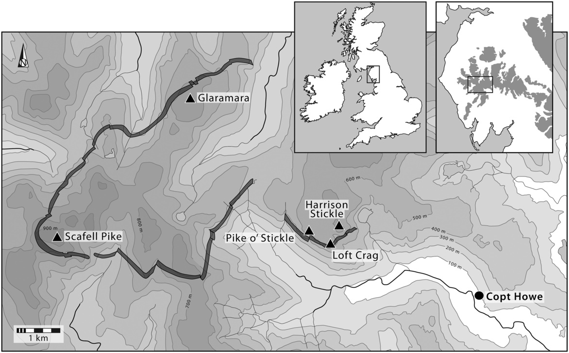
Fig. 1. The location of Copt Howe in relation to the principal axe production sites and the exposure of Group VI tuff
THE LANGDALE PIKES
The rock used for making axes outcropped in a narrow band which extended for 19 km. The principal extraction sites were on the Langdale Pikes where the largest quantities of surface finds come from Pike o’ Stickle, Harrison Stickle, and Loft Crag. Other groups are recorded on Glaramara and Scafell Pike. According to different methods of quantifying them, the Langdale stone source accounts for between 85% and 95% of all the material recorded in this region. Between 4% and 14% is on Scafell Pike, and there is about 1% at Glaramara (Bradley & Edmonds Reference Bradley and Edmonds1993, table 4.1; Bradley & Watson forthcoming a & b).
The stone was treated in two ways (Bradley & Edmonds Reference Bradley and Edmonds1993, chaps 5–7). The simpler and less efficient method was to obtain readily accessible material, sometimes from opencast quarries, to test its suitability and reduce its bulk before it was removed to work camps in more sheltered positions. Here it was made into roughouts which were removed to settlements in the lowlands where they were ground and polished. An alternative was to extract the rock more systematically, using fire setting at some of the quarries. Hammerstones were introduced from different parts of Cumbria to help in acquiring the rock (Bradley & Suthren Reference Bradley and Suthren1990). In this case, all the stages of roughout production were undertaken in the same place and less raw material was wasted.
New work shows that the main period of axe production on the Langdale Pikes was earlier than originally thought (Edinborough et al. in press). It is estimated as starting between 3981 and 3731 bc, with a mean of 3828 bc. The end of directly dated activity is estimated at between 3491 and 3135 bc, with a median of 3308 bc. These dates do not suggest a sequence of different working methods, nor do they support the idea that axe production remained important during the Late Neolithic period. The interpretations put forward in 1993 need to be reconsidered.
COPT HOWE
Close to the river that runs below the Langdale Pikes is a conspicuous group of rocks beside a roughly circular mound of glacial debris. It is thought that the stones (also known as the Langdale Boulders) fell downslope during the Ice Age or may have been transported by a glacier. The two largest (Rocks 1 & 2) are separated by a gap 5 m wide which was closed in the 19th century by a field wall. It resembles a massive but entirely natural portal and commands a view towards the quarries on Harrison Stickle (Fig. 2; Sharpe Reference Sharpe, Mazel, Nash and Waddington2007; Sharpe & Watson Reference Sharpe, Watson, Barnett and Sharpe2010). The site is located at a constriction above which the valley opens out. Someone looking between these stones would have seen the midsummer sun setting into the source of Group VI rock (Sharpe Reference Sharpe, Mazel, Nash and Waddington2007). To either side of this division the vertical surfaces of the rock are embellished with pecked designs which complement a series of cup marks of geological origin. The decorated surfaces could be observed by an audience on the natural mound immediately to their east. To its west this portal provides access to an area of roughly level ground bounded by a slight ridge. An earthwork resembling a long barrow extends along the top of this feature and shares its orientation. The south-east face of Rock 1 features a series of prominent flake scars (Fig. 3). Some may have formed as the boulders tumbled downhill or were sheared off from the bedrock by the movement of ice. Others seem to result from people removing smaller pieces of stone. The rocks themselves were andesitic tuff and could not be used for making axes.
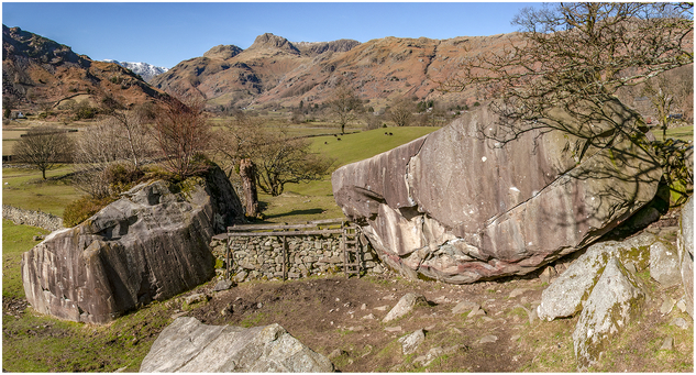
Fig. 2. Looking west between the decorated Rocks 1 (left) and 2 (right). Photograph: Aaron Watson
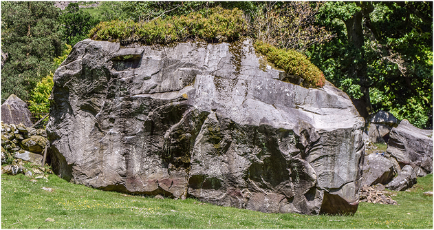
Fig. 3. Flake beds on the south-east face of Rock 1. Photograph: Richard Bradley
The entire complex was recorded by airborne photogrammetric survey undertaken by Jamie Quartermaine and Pete Schofield. To the west of the decorated boulders geophysical survey was carried out by Chris and Vince Gaffney but did not identify any subsoil features. The pecked designs have also been studied using up-to-date methods of analysis. When they were first found they had to be recorded by rubbings and photographs, but now a new record has been compiled using photogrammetry. It allowed minute differences in the surface of the rock to be examined and previously unknown motifs to be identified. It also made it possible to look for modifications of the images themselves. All but one of the pecked motifs were on the north-east face of Rock 1 (Fig. 4; Bradley & Watson forthcoming b). The only exception was on the south face of Rock 2 (Fig. 5). The other surfaces were investigated by the same method, but there were comparatively few places where decorated panels could have been destroyed.

Fig. 4. Pecked motifs on Rock 1 before the excavation. Photograph: Aaron Watson

Fig. 5. The single pecked motif on Rock 2, with Rock 1 in the background. Photograph: Aaron Watson
The result of the exercise was to show that the designs are very different from the usual repertoire of rock art in northern England (Beckensall Reference Beckensall2002). Artificial cup marks, cups and rings, grooves and radial lines are absent. Instead there are unfamiliar motifs like concentric circles, spirals, and a triangle; and all these are organised as vertical panels which contrast with the horizontal surfaces on which most pecked motifs are found. The same elements feature in megalithic art. The designs at Langdale are paralleled in Irish passage graves, and particularly those in the Boyne Valley (Watson & Bradley Reference Watson, Bradley, Brophy and Barclay2009).
CHRONOLOGICAL RELATIONSHIPS
Chronology is important here. Axes were made on Pike o’ Stickle between about 3800 and 3300 bc. So close is the comparison between the images at Copt Howe and those associated with passage tombs that they must have been contemporary with one another. Irish megalithic art is accurately dated as a result of excavations at Newgrange, Knowth, and Tara, and it seems likely that its currency was restricted to the period between 3300 and 2900 bc (Eogan & Cleary Reference Eogan and Cleary2017, chap. 4). As a result it is difficult to connect axe making with the designs at Langdale. By 3300 bc the quarries were being abandoned or little used; the same is true of flint mines in the south (Edinborough et al. in press). This conclusion is supported by the contexts of Group VI artefacts in other parts of Britain, most of which are found with Early and Middle Neolithic pottery. Arguments for a Late Neolithic currency were influenced by their association with Impressed Ware/Peterborough Ware (Smith Reference Smith, Clough and Cummins1979), but this ceramic tradition has since been backdated (Ard & Darvill Reference Ard and Darvill2015).
This revised chronology suggested two hypotheses:
Firstly, the choice of Copt Howe was influenced by the significance of axes made on the Langdale Pikes. Those mountains retained their importance after quarrying there came to an end (and Loft Crag was reused for making Beaker bracers or wrist guards [Woodward & Hunter Reference Woodward and Hunter2011, 29 & 35]).
Secondly, the pecked designs at Copt Howe date from the end of the 4th millennium bc and may have been employed in a similar manner to those in passage tombs, some of which were directed towards the solstices.
Until 2018 the complex had been recorded by non-invasive methods. Now these ideas had to be tested by excavation.
EXCAVATIONS AT COPT HOWE
Small-scale excavation took place at Copt Howe in 2018 (Fig. 6). It had the following aims:

Fig. 6. The extent of excavation in 2018, showing the positions of Rocks 1 and 2 and that of the putative long barrow. Contours at 5 cm intervals. From a drone survey by Jamie Quartermaine & Pete Schofield (Oxford Archaeology North)
Rock 1
Trenches 1 and 3 were separated from one another by a field wall, but both had the same objective: to find the original ground level below the decorated surface and to discover whether any further motifs were preserved. It would also establish whether artefacts had been deposited there. It was also important to look for structural evidence, although none had been found by geophysical survey. Trench 3 was therefore extended beyond the limits of the rock to investigate an approximately level area west of the decorated stones.
Rock 2
Rock 2 was the opposite side of the decorated ‘portal’ but was less well preserved. A substantial part of its south face had been detached, and only one pecked motif survived. It seemed possible that the decoration was originally more extensive. Trench 2 investigated this. Its main aim was to establish the original extent of the outcrop, but it would also look for discarded hammerstones or other tools whose distribution might show where further designs had been. Pieces of stone that had fallen from the outcrop were examined for prehistoric images. Unlike Trenches 1 and 3, this excavation could not be placed directly beneath the panel of rock art as the area was too disturbed.
The putative long barrow
The oval mound to the west of the Langdale Boulders was a recent discovery, and its credentials as a possible long barrow were by no means clear. Trench 4 was excavated in order to establish its structure and date.
THE RESULTS OF EXCAVATION
Trenches 1 and 3
These two trenches are treated together as they investigated the same features on either side of the wall that cuts across the site. Both were located directly beneath the motifs on the east-facing side of Rock 1 (Panels 1 & 2).
In each case the stratigraphic sequence was the same. The ground along the base of the outcrop had been exposed to stream erosion. Here three large blocks were placed against the rock face (Fig. 7). Their distribution was confined to Trench 1 where they were immediately below the principal concentration of motifs (Panel 1). There was a space in between two of the stones where a prominent fissure extended down the surface. The same combination of cultural and natural features was evidenced by a cobble with a cup mark of geological origin. It was on the original ground level and partly covered by one of the boulders. Although the vesicle was entirely natural it was enclosed by pecking a narrow ring.
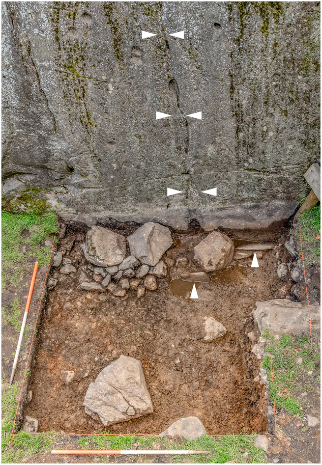
Fig. 7. Trench 1 showing the row of large boulders against the base of Rock 1. Two large vertical flakes are visible in the top right of the excavated area, indicated by arrows. The prominent vertical fissure is indicated by paired arrows. Photograph: Aaron Watson
This stone setting was covered by a stone and rubble platform a little over a metre wide and 40 cm high piled against the decorated rock (Fig. 8: Contexts 3, 4, & 5). It is clear that the structure was not intended simply to stabilise an area of damp ground. Its base was flush with the underside of Rock 1. The platform was composed of grey, mainly angular stones, 25–30 cm in maximum dimensions, and it did not have a kerb. It is difficult to estimate the full extent of this structure. A pronounced step in the surface topography suggests that it extended southwards for about a metre beyond the edge of Trench 1. It is not clear how far it might have continued beyond the limit of Trench 3. Its overall extent is uncertain, but it must have followed the foot of the rock for at least 8 metres.

Fig. 8. North-facing section of the platform built against the decorated rock in Trench 1
There was an important contrast between the two exposures of this platform (Fig. 9). In Trench 3 there were three horizontal slabs on its surface of a kind which could have been obtained on the site; the largest was 60 cm long. Only one was observed in the other trench. In both the excavated areas large flakes of andesitic tuff were set vertically in the ground. In two cases it happened at the point where the surface of the platform met the rock face. A possible source is suggested by the scars on the south side of Rock 1.

Fig. 9. The surface of the platform as first exposed in Trenches 1 and 3. The plans shows the positions of several flat slabs, large flakes set vertically in the material of the platform, the cache of stone tools, and the cup-marked cobble. It also illustrates the relationship between a prominent fissure exposed in the face of Rock 1 and a line of boulders visible in the surface of this structure
In Trench 1 the lower part of this deposit (Context 4) contained a remarkable cache of stone artefacts that may have been used to decorate the rock. They included a series of three ‘rods’ or ‘bars’. Another two possible examples were found with them. There were no hammerstones. This collection was also associated with a retouched point or borer and a cobble of Group VI tuff which had probably been transported by ice long before it was worked. In both trenches there were struck flakes or thin slabs of rock within the material of the platform. Some were probably obtained on the site, and others made use of stream pebbles.
In Trench 1 two pecked motifs – two nested arcs, and four concentric rings – were concealed behind the stonework (Fig. 10). They extended down to the old land surface and must have been made before that structure was built. The platform was just high enough to conceal them from view, and this may have been intended. Like those already known at Copt Howe, the newly discovered motifs have parallels in Irish passage graves (Figs 11 & 12; Shee Twohig Reference Shee Twohig1981; Robin Reference Robin2009). That is fortunate as the land surface beneath the platform did not produce suitable samples for radiocarbon or Optically Stimulated Luminescence dating. For that reason the chronology of the site must be based on stylistic criteria.

Fig. 10. The pecked motifs at the base of Rock 1 on completion of the excavation. The two designs lower right were new discoveries sealed by the material of the platform. The white stain on the rock face shows the position of land surface before fieldwork began. The dark line extending from the bottom of the designs found in 2018 is the position of the Neolithic ground surface. Photograph: Aaron Watson

Fig. 11. An interpretation of the motifs on Panel 1 (above Trench 1) based upon photogrammetry. Shades of grey reflect the relative clarity of each motif, with black being the most distinct. Geological features on the rock surface are indicated as grey lines with the central fissure emphasised by a black line. The dashed grey line represents the ground surface before excavation. Photogrammetry: Aaron Watson

Fig. 12. An interpretation of the motifs on Panel 2 (above Trench 3) based upon photogrammetry. Shades of grey reflect the relative clarity of each motif, with black being the most distinct. Natural features on the rock surface are indicated as grey lines. Photogrammetry: Aaron Watson
There were other striking relationships between the pecked decoration and the organisation of the platform. Some of the motifs in Trench 1 were directly linked with a prominent fissure running down the rock. Its position had been acknowledged in locating the large stones on the land surface, but when the platform was built over them the same axis was retained as a line of boulders (Fig. 13). Its position was also acknowledged by a cup-marked stone described below.
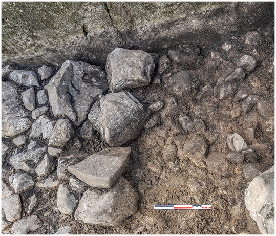
Fig. 13. The line of boulders exposed in the surface of the platform in Trench 1. Photograph: Aaron Watson
Another connection between the platform and the rock art was recorded in Trench 3. Here a similar vein extended down the rock face and connected a series of geological and archaeological features: three or four natural cup marks or basins, two sets of lightly pecked concentric circles, and a horned spiral that made use of an existing crack (Panel 2). The alignment ended with a shallow cavity at the bottom of the stone. Where the fissure disappeared behind the rubble platform a particularly large flake was buried in its surface. Like examples in Trench 1, it was set upright against the rock face.
In both excavated areas the platform was abutted by a deposit of orange clay (Context 2) which had eroded down the hillside where the same material was represented in Trench 2. In contrast to the prehistoric structure, it contained rounded cobbles and did not include any artefacts. Although the area between the decorated rocks has been compared with the forecourt of a tomb (Sharpe & Watson Reference Sharpe, Watson, Barnett and Sharpe2010), Trench 3 found no prehistoric material there, and the only subsoil feature was a charcoal-filled pit containing a pickle jar made in the 1960s.
Trench 2
Excavation against the foot of Rock 2 showed where a section of the stone had split off from the rest. A limited part of its surface had been detached and there must always have been a natural overhang. Most of the fallen material had been removed, but a few slabs remained and were examined for pecked decoration. None was found and there were no prehistoric hammerstones or other tools. There was no evidence that more of the stone had been decorated than appears today, although the possibility cannot be excluded. Today the only pecked motif is at, or slightly below, average eye height, suggesting that the ground surface may not have changed significantly since the design was made. At the foot of this boulder the deposit of orange clay observed in Trenches 1 and 3 was covered by a lens of charcoal, but it contained modern artefacts. There was one struck flake from a superficial deposit. Attempts to date the rock fall by Optically Stimulated Luminescence were unsuccessful, as there were no suitable samples.
Trench 4
The earthwork was sectioned on its southern flank where it had been damaged by livestock. Although it had the same profile as a long barrow, it was composed of glacial debris. A hollow that resembled a shallow ditch was caused by grazing animals. The steep southern terminal of the mound may have been enhanced by the plough. No artefacts were found and no archaeological features were associated with the mound which was of natural origin.
THE EXCAVATED MATERIAL
Formal artefacts
The lower part of the rubble platform was associated with a group of four distinctive artefacts: three unmodified rods or bars suitable for creating the pecked designs, and a retouched point or borer (Fig. 14). The rods were of the same material as the Langdale Boulders. With them there was a large rounded boulder of Group VI tuff which seems to have been tested for quality before it was deposited; very few flakes had been removed. Despite its distinctive appearance, it was almost certainly a glacial erratic and had not been brought from a quarry.

Fig. 14. The cache of stone artefacts deposited in the material of the platform in Trench 1. Photograph: Aaron Watson
The borer was made from a rounded pebble which had been trimmed to shape by removing a series of small flakes. Its tip seems to have fractured in use. The three rods were remarkably similar in size and shape and were found together. Informal experiments on detached boulders at the site show that they would have been capable of making the pecked designs without the use of a hammerstone. Unfortunately, this process did not leave any distinctive traces on the working edge. The same applies to the excavated examples. Although the experimental evidence is compelling, the argument that these rods were used to work the rock depends on their context in the platform. There they were associated with the borer and the one piece of Group VI tuff.
Debitage
With the exception of a single flake from Trench 2, all excavated debitage came from Trenches 1 and 3 and was directly associated with the material of the rubble platform. None was found in the deposit of hillwash which abutted this feature.
The collection comprised 36 pieces of worked stone, almost all of them tuff of the kind that could be collected on or around the site. This small assemblage included ten cobbles or chunks from which occasional flakes had been removed, but there were no regular cores. In some cases they were difficult to distinguish from stream pebbles or other stones that had suffered mechanical damage as they washed down the valley. The pieces varied in size and the largest may have been obtained at Copt Howe where the southern edge of Rock 1 featured a series of flake beds. None of the flakes was retouched and they may not have been a by-product of artefact production. In fact, their only distinctive feature was the large size of the pieces set vertically in the material of the platform. The same happened with three thin slabs of the same material that could have been obtained on the site itself.
Cup-marked cobble
On the old land surface partly covered by a massive boulder in Trench 1 was a detached block which included a natural vesicle in its surface. It was placed at the foot of Panel 1. The stone does not seem to have been quarried but may have been deliberately squared. The cup itself was a geological feature and was left unmodified, but it had been enclosed by pecking a narrow ring (Fig. 15).
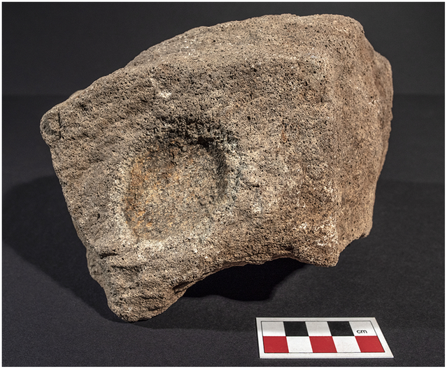
Fig. 15. The worked cobble found in the base of the platform in Trench 1. The cup mark is a natural vesicle, but it is enclosed by a narrow pecked ring, highlighted by its lighter colour. Photograph: Aaron Watson
DISCUSSION
The location of Copt Howe
Despite the discovery of worked stone during the excavation, none was associated with the production or maintenance of axes. Nor were there any pieces of Group VI tuff of the kind associated with quarries on the Langdale Pikes. Few artefacts were found at Copt Howe and most of the raw material seems to have been obtained on the site. Although struck flakes did come from prehistoric contexts, the only tools were for making the motifs. Although the choice of this location may have acknowledged the importance of local mountains, their use as an important stone source could already have been in the past. That is consistent with the revised dating of the quarries and the chronology of megalithic art.
The site is located where Great Langdale opens to reveal a series of peaks. It is also where the quarries on Harrison Stickle and Loft Crag come into view (Pike o’ Stickle cannot be seen from Copt Howe). The flanks of the valley are so steep that the area is best approached from the low ground to its east. Seen from this direction, the Boulders and the mound are landmarks even now. Rocks 1 and 2 are especially conspicuous and the narrow space between them commands a direct view of the sun as it passes behind Harrison Stickle at midsummer and sets into the high ground a short distance to its north. That would have been an impressive spectacle long after axe production had ended (Fig. 16). At the same time the profiles of the two largest rocks are strikingly similar to those of Harrison Stickle and Loft Crag respectively. Viewed from the flank of the circular mound the form of Rock 2 echoes that of Harrison Stickle (which appears to be the higher of the pair), while the outline of Rock 1 resembles that of Loft Crag. Such an obvious relationship can hardly have gone unnoticed.

Fig. 16. Upper. The setting midsummer sun in relation to Harrison Stickle, as observed through the space between Rocks 1 and 2. Lower. The midsummer sun as it sets into the horizon just north of Harrison Stickle. Photographs: Aaron Watson
It is impossible to say whether the round mound was identified as a deliberate creation. Barrows of similar proportions were built during the Middle Neolithic period in northern England (Gibson & Bayliss Reference Gibson and Bayliss2009; Reference Gibson, Bayliss, Leary, Darvill and Field2010), and it could have been interpreted as an ancient monument, but a similar argument ought to apply to the earthwork investigated by Trench 4 where there was no evidence of human activity. On a smaller scale, people in the past would have seen the vesicles in the surface of the stones. Although these are of geological origin, several examples occur among the pecked designs and a cobble with a similar feature was partly reworked. Some of the most prominent examples are higher up the rock than the pecked motifs. It seems possible that such features were understood as older rock art. The distinction between culture and nature is not helpful here.
The organisation of the pecked motifs
The pecked motifs are integrated with the features of the stone. The two panels on Rock 1 are separated by a cleft and executed in different ways. Similarly, the irregular design on Rock 2 is unlike all the others. Depending on the position of the sun, all these panels can be highlighted at particular times of day. Experiment has shown that when the motifs were newly made they would have been green or blue, but this effect would fade with exposure to the elements. Once that had happened they would be easiest to recognise when oblique sunlight cast shadows across the decorated surface. It was a gradual process. Observations in June 2018 showed that the motifs in Panel 2 could be recognised before those in Panel 1 which were illuminated for about an hour. The single design on Rock 2 was visible for a shorter time as the sun reached its zenith in the afternoon.
Although the images masked by the platform may have been among the oldest at Copt Howe, there is no reason to suppose that the designs in Panel 1 extended up the rock over time. In fact, the upper part of the panel is fainter and possibly more weathered than its lower level. It is obvious that certain elements were pecked more deeply than others. In that case, the images on Rock 1 can be divided into several different groups (accepting that some were truncated or destroyed when part of its surface was lost). One consisted of the designs hidden by the construction of the platform. A second includes the boldly executed rock art immediately above Trench 1. It was very different from the more ephemeral designs in Panel 2, and these groups were separated from one another by a cleft in the stone. Lastly the poorly preserved designs on the upper part of Panel 1 were distinct from the bolder designs lower down which have more in common with those at the south-east edge of the decorated surface.
The main distinction concerns techniques of working the rock. The larger designs were boldly executed, while some of the faintest images were formed by narrow lines and may have been made by a different kind of tool. Perhaps the contrast was that between the rods deposited in the rubble platform and the retouched point from the same context. The simplest explanation for most of these contrasts is that Rock 1 was worked on several occasions.
How were these designs organised in relation to one another? Individual motifs respected or abutted those already present, and there is little to suggest that they were superimposed. In one case a series of finely incised rings were enclosed by two concentric circles made by a different technique, and in this instance an older motif may have been enhanced. If the locations of the pecked designs were influenced by the veins extending down Rock 1, another element was a conspicuous crack which extends across Panel 1 running parallel to the land surface. It must have been present during the Neolithic period as it separates several well-preserved designs. Two of them – a prominent angular motif and a set of nested arcs – seem to emerge from this feature. Similarly, the larger circles and spirals in the main group of images were above the crack, and smaller designs of similar character were generally underneath it; that does not apply to the isolated group at the south-eastern limit of Panel 1.
The variety of pecked motifs
In northern Britain open air rock art is largely curvilinear, but the motifs at Copt Howe are much more varied. On Rock 1 there are concentric circles and spirals, but there are also more linear components – a small square, a rectangle filled with shallow peck marks, a conspicuous angular motif defined by three parallel grooves, and a triangular area of dots. There is also a horned spiral which combines both linear and curvilinear elements. Rock 2 features a poorly executed oval design.
These distinctive components can be paralleled individually on British sites, but the full range of motifs found at Copt Howe can only be matched at monuments in Ireland. A few elements are shared with sites in the Eden Valley in Cumbria – Long Meg, Little Meg, and Glassonby – and they have long been compared with megalithic art (Beckensall Reference Beckensall2002, 59–70, 79–84 & 84–90; Watson & Bradley Reference Watson, Bradley, Brophy and Barclay2009). But the most telling comparison is perhaps the simplest. Like Copt Howe, the decorated tombs combine linear and curvilinear elements in a unitary scheme (Bradley Reference Bradley2009, 120–2). Among the commonest are circles, spirals, and triangles. Cup marks are rare at some of the sites, and there is little indication of the gapped circles and radial lines that occur on decorated outcrops (Bradley Reference Bradley1997, chap. 5). Three of the most distinctive motifs at Copt Howe have more specific parallels. The narrow rectangle filled with peck marks is like a design in the cemetery at Loughcrew (Shee Twohig Reference Shee Twohig1981, fig. 218), and the nested arcs, one of which was concealed behind the platform, are a notable feature of the entrance stone at Newgrange (O’Kelly Reference O’Kelly1982, pl. iv & 154–5). Similarly, horned spirals are known in the Orcadian Neolithic, although their distribution extends to an unusual chambered tomb at Millin Bay in Ulster (Collins & Waterman Reference Collins and Waterman1955, 28–43). The motifs found there resemble those on a stone setting at Old Parks in Cumbria (Beckensall Reference Beckensall2002, 90–8). Recently, several of these monuments have been dated. Newgrange was probably built and used between 3200 and 3000 bc and Knowth between 3160 and 2900 bc (Eogan & Cleary Reference Eogan and Cleary2017, chap. 4). The unusual structure at Millin Bay has produced a wider scatter of dates, but those for two samples of burnt and unburnt human bone overlap between 3380 and 3050 bc (Schulting et al. Reference Schulting, Murphy, Jones and Warren2011).
Copt Howe and passage tombs
Copt Howe shares its distinctive imagery with megalithic monuments in Ireland. To a lesser extent the same applies to chambered tombs in Anglesey and Orkney, but in every case there is an important contrast. By their very nature passage graves are permeable structures. Certain people could enter the mound and access a chamber. Others could have inspected the pecked designs on the kerbs retaining these monuments. The Langdale Boulders were themselves solid, but it would be possible to pass between them. That is why they have been interpreted as an entrance to Great Langdale, but, apart from the platform below Rock 1, there is no sign of any built structure.
On the other hand, the portal shares three features with decorated tombs in Ireland. Its most obvious attribute is that it commands a dramatic view of the midsummer solstice when the sun passes behind Harrison Stickle – an important source of axes – and sets into the horizon where there is direct evidence for the working of Group VI rock. That relationship could have been observed long before either stone was embellished.
Although it is easy to view the sunset from Copt Howe, there is another way of thinking about this relationship. A small proportion of the passage tombs in Ireland faced the sun at the turning points of the year, but this may well have happened, because it illuminated the interior of these monuments. The best-known example of this relationship is the midwinter sunrise at Newgrange (O’Kelly Reference O’Kelly1982). In the same way the light of the sun travels from the mountaintop and passes between the Langdale Boulders.
Fieldwork to observe solar alignments at passage tombs in Britain and Ireland has revealed a variety of dramatic effects (Watson & Scott in press). A beam of light crosses the floor of these monuments and illuminates the rear wall. A comparable effect was noted at Copt Howe during midsummer sunset in June 2018. The shadows cast by Rock 1 and Rock 2 defined a ‘pathway’ of sunlight which traversed the ground for several metres to illuminate a sizeable angular boulder which acts like the back stone in a passage tomb. While it is possible that this rock has fractured since the Neolithic, distinctive geological patterns mark the side of this boulder which faces into the sun (Fig. 17). This has a further implication. Several writers have observed that Irish monuments place a special emphasis on the right-hand side; here the chambers are larger, they contain more artefacts and deposits of burnt bone, and they may be more lavishly decorated. Viewed from the direction of the sunset, nearly all the motifs at Copt Howe are on the right-hand side of the passage between the stones (Robin Reference Robin2009, fig. 178; Hensey Reference Hensey2015, fig. 2.4). This raises the possibility that participants at the summer solstice approached and entered the site from the west.

Fig. 17. Upper. Shadows cast by the boulders at midsummer sunset create a path of light which is directed towards a large block. To remove the intrusion of the modern wall, this digital reconstruction combines a photogrammetric model with on-site observations and photography. Lower. Natural ripples upon the surface of the block illuminated at midsummer sunset, highlighted by oblique afternoon sunlight. Photograph: Aaron Watson
It was on the same side that a platform was constructed after the earliest motifs were in place. Stone settings were built close to, or even against, the decorated kerbs of Irish tombs, although they do not take the same form. They are best documented at the entrances of the principal monuments at Newgrange (O’Kelly Reference O’Kelly1982) and Knowth (Eogan & Cleary Reference Eogan and Cleary2017). They can be associated with deposits of artefacts, but the toolkit found at Copt Howe lacks any parallels on these sites.
A further connection between the Langdale Boulders and Irish passage tombs is the concealment of images. In Ireland it is accepted that decorated stones were recycled from older monuments (Robin Reference Robin2009, 255–87). It is possible that they had lost their significance by then, but there is compelling evidence that decorated panels might also be modified or erased (Hensey Reference Hensey2015, 123–32). A similar practice may have taken place at Copt Howe where the stone platform was just high enough to conceal two pecked designs. It could hardly have happened by chance.
Guillaume Robin has observed that the architecture of Irish passage graves features a series of thresholds (Robin Reference Robin2009, 212–14). There is an entrance and often a kerb. There may be a series of side chambers, and the passage can be subdivided by sills. In many cases such thresholds were highlighted by pecked motifs, so that the distinctive structure of the monument was emphasised by the positioning of rock art. Robin observes that certain motifs were most appropriate in particular parts of these buildings. That applies to at least three of those represented at Copt Howe. Spirals are a feature of the outer kerbs of passage tombs (although they occur elsewhere); nested arcs of the kind represented at Langdale follow the course of the entrance passage; and triangular motifs appear in the principal chamber (Robin Reference Robin2009, fig. 162).
Entering the rock
The decorated boulders at Copt Howe can be considered as a threshold. They marked the entrance to a landscape that played a special role in the Neolithic period (Watson & Bradley Reference Bradley2009). Robin’s analysis of the decorated tombs has less application as Rocks 1 and 2 are solid structures. On the other hand, it is obvious that the people who made the designs incorporated the striations and hollows in the stone and gave them a particular significance. That is most obvious with the veins running down the surface of the rock. Other features may have been equally important: the vesicles exposed in the boulders; the prominent crack which separates different groups of images; and the remarkable rectangular cavity at the bottom of Rock 1 which was located directly below the motifs in Panel 2 (Fig. 18). Could these geological elements have been conceived as thresholds in the past?

Fig. 18. A digital model of Panel 2 on Rock 1 following excavation. Oblique illumination and an artificial texture reveal the vertical distribution of pecked motifs and natural elements, including the square cavity at the base of the stone sealed by the construction of the platform. Photogrammetry: Aaron Watson
One of the most influential discussions of rock art is by David Lewis-Williams and Thomas Dowson (Reference Lewis-Williams and Dowson1990). Drawing on ethnographic evidence from southern Africa, they suggest that the surface of a decorated stone was not necessarily impermeable. Individual drawings seem to emerge through cracks in the rock and spirits were able to pass between the outer world and the interior. The same idea is recorded in other societies and might explain why artefacts were inserted in cracks and fissures at similar sites in Britain and Scandinavia (Bradley Reference Bradley2009, chap. 9). A few of the motifs at Copt Howe do come out of such features, and in any case the act of pecking penetrated the surface of the rock in a way that would not be true of a painted design. The rings and spirals could even have been considered as tunnels, as Dronfield (Reference Dronfield1996) has suggested in Irish megalithic art.
In this case there was a particular emphasis on the underside of the stone. This is illustrated by the attention paid to striations and veins running down the rock face, but it is shown by three other features. The nested arcs concealed behind the platform beneath Rock 1 have been compared with similar motifs on the entrance stone at Newgrange and could have been seen as the visible parts of circles that continued underground. A second element is the setting of large flakes vertically in the rubble platform. In two cases they had been inserted against the rock face as that structure was built. These deposits are remarkable since the raw material may have been detached from an undecorated part of the same stone. It raises another possibility. Were the conspicuous flake beds on Rock 1 compared with those in the quarries on Pike o’ Stickle (Bradley & Edmonds Reference Bradley and Edmonds1993, chap. 4)?
Lastly, the series of pecked designs and geological elements comprising Panel 2 extended down the surface of the stone and reached its underside where it was hidden by the platform. At the level of the original ground surface there was a shallow rectangular cavity. It did not contain any artefacts, but people had gone to some effort to close it, because the base of that platform in Trench 3 was built from particularly large boulders. A similar feature is found on an Irish site discussed by Robin (Reference Robin2009, 238–9). At Slievenamon a large square rock was buried beneath a mountaintop cairn reminiscent of a passage grave; more orthodox monuments of the same kind were represented in the vicinity, including a recently discovered cursus (Kenny Reference Kenny2014). In this case there was no chamber or passage, but the focal point of the structure was a rectangular cavity in the vertical wall of the outcrop (Fig. 19). Its equivalent at Copt Howe was much smaller, but its special importance was indicated by the designs above it. Was it considered to lead into the interior of the stone?

Fig. 19. The mountaintop cairn and outcrop at Slievenamon, Co. Tipperary, Ireland, showing the natural ‘portal’ leading into the rock. We are grateful to Guillaume Robin for the use of this image
CONCLUSION: BETWEEN CUMBRIA AND IRELAND
The Copt Howe boulders may have been understood as a remarkable place throughout earlier prehistory, but there is sufficient evidence to show that they achieved special significance as activity on the Langdale Pikes came to an end. The most striking outcome of the project is the recognition that by 3000 bc, if not earlier, the archaeology of north-west England was closely allied to that of Ireland and the eastern seaboard of the Irish Sea (Sheridan Reference Sheridan, Roche, Grogan, Bradley, Coles and Raftery2004; Sheridan & Cooney Reference Sheridan and Cooney2014; Carlin Reference Carlin2017). Studies of passage tombs have attracted most attention, but similar links are illustrated by early henges, house plans, stone and timber circles, and a new ceramic tradition – Grooved Ware.
These connections became more important over time and provide evidence for the emergence of new networks during the Late Neolithic period. It is instructive to compare relations between northern Britain and Ireland during each of the phases represented in Great Langdale. Group VI axes were made on the high ground between approximately 3800 and 3300 bc, after which production diminished or ceased. During that time it is estimated that the Cumbrian sources accounted for at least 21% of the non-flint axes circulating in Britain (Clough Reference Clough, Clough and Cummins1988, 4). Recent research in Ireland has increased the number of axes known from the same source and sheds new light on their morphology and the contexts in which they were found. Although their forms are not unlike those of porcellanite artefacts which were imported to Britain, they account for less than 1% of the axes identified by this study (Cooney & Mandal Reference Cooney and Mandal1998, chap. 5). Similarly, those from Ulster account for little over 4% of those in England, Wales, and Scotland (Clough Reference Clough, Clough and Cummins1988, table 2). Of course, there were close contacts between the two islands, illustrated by monument types, ceramic styles, and the movement of materials like pitchstone, but they should not be overestimated. Irish elements are easier to recognise in western Britain from the end of the 4th millennium bc. They include the distinctive evidence from Copt Howe and occasional echoes of megalithic art elsewhere in north-west England.
Another contrast is potentially more informative. Axes – whether made in Cumbria or the flint mines of southern England – were essentially work tools and would have served a practical purpose even when they changed hands on special occasions. No matter how unusual the contexts in which they are discovered, they had often been used and repaired. That may have ended around 3300 bc. After that time new geographical alignments formed (Walker Reference Walker2018, chap. 8). Links with the west and Ireland assumed a greater significance, but they were associated with new beliefs rather than a novel toolkit (Sheridan & Cooney Reference Sheridan and Cooney2014). After the dissemination of axes, the Neolithic period changed. The sequence studied in Great Langdale epitomises a wider development.
Acknowledgments:
Copt Howe is a Scheduled Ancient Monument, and we are grateful to Historic England and the National Trust for permission to work there. Special thanks are due to Andrew Davison (Historic England), Jamie Lund (National Trust), and Eleanor Kingston (Lake District National Park). The work was funded by grants from the Prehistoric Society, the Royal Archaeological Institute, and the Lake District National Park. We must also thank all those who took part in the fieldwork: Yvonne Luke, Diane O’Leary, Nick Russell, Ronnie Scott, Kate Sharpe, Moyra Simon, and Sally Taylor. Photogrammetry of the rock art was undertaken by Aaron Watson, with analysis assisted by Kate Sharpe and Peter Style. The photogrammetric survey of the site was undertaken by Jamie Quartermaine and Pete Schofield (Oxford Archaeology North), and geophysical survey by Chris and Vince Gaffney (University of Bradford). Thanks are also due to Guillaume Robin for his photograph of Slievenamon and Stephen Shennan for details of the new radiocarbon dates.


