Introduction
Various authors have dealt with the historical context, decisions behind, organisational arrangements of, and leading personalities associated with the first IPY (Heathcote and Armitage Reference Heathcote and Armitage1959; Taylor Reference Taylor1981; Chapman Reference Chapman1959a, Reference Chapman1959b; Anon. 1982; Baker Reference Baker1982; Corby Reference Corby1982; Lüdecke Reference Lüdecke2004; Barr Reference Barr1983, Reference Barr2008). The significance both of the cold war and of the geopolitical conditions under which the IGY evolved have also been discussed (Dodds Reference Dodds1997; Doel Reference Doel, Krige and Pestre1997, Reference Doel2003; Elzinga Reference Elzinga2007 in press a; Hamblin Reference Hamblin2005, Reference Hamblin, Rozwadowski and Benson2007; Krige Reference Krige2006; Lewander Reference Lewander2007; Needell Reference Needell2000; Rozwadowski and Benson Reference Rozwadowski and Bension2007; Bulkeley Reference Bulkeley2008). Less, however, has been written about the second IPY. In this paper the primary concern is with the character of the research carried out during all of the polar years including the current one.
Each section begins with a brief sketch of the geopolitical setting in which the polar year took place. This contextualisation serves to remind us that each of the four polar years is embedded in a particular historical set of world economic and political circumstances. Geopolitical conditions obtaining in each era had (and have) specific bearing on the general potential, limitations, and the thrust of the periodic scientific efforts under review. Of course, technological factors also apply, but neither these nor scientific interests by themselves are sufficient to understand why, for example, the Antarctic came so strongly into focus during the IGY, or why the majority of projects under the fourth IPY have a predominantly Arctic focus.
The first IPY took place in an era of classical imperialism, the second at a time of economic crisis, while the IGY bore the imprint of the cold war that followed soon after World War II. The present IPY is contemporaneous with a new era, one characterised by new pressures both internal and external to science. High on the current agenda is the production of knowledge to address global climate change and to provide advice on the protection and future management of the natural environment with its complex ecosystems and biodiversity. Co-operative research cutting across disciplinary boundaries challenges traditional institutional structures and norms. Equally, the present period shows a reconfiguration of geopolitics that has emerged after the end of the cold war. This has opened up new avenues for research co-operation across the former east-west divide. Decolonisation has caught up with the polar regions, the human dimension is important, and the scramble is on to map the seabed and to extract natural resources out of a more easily accessible Arctic. Here too, polar research is asked to integrate with multi-levelled modes of governance, engaging with indigenous people and their local knowledge under a dual banner of democracy and sustainable development.
The first International Polar Year
Geopolitical setting
The geopolitical setting of the first IPY was one in which a few great European powers dominated the scene: the British empire, the German empire, the French third republic, the Russian empire, the Austro-Hungarian empire, and Italy. The internationalist ideal advocated by the architects of the first IPY deviated sharply from those of the imperialist rulers. Political will did not match scientific will and this created problems. Russia with its vast Arctic coastline and waters was obviously important when setting up a belt of stations around the Arctic to carry out systematic simultaneous meteorological, magnetic and other geophysical measurements over at least one year. When these plans were in the offing, however, Russia had just commenced hostilities against the Ottoman Empire in the Balkans (the Russo-Turkish War 1877–1878). This seriously delayed the international polar enterprise. Thereafter several practical difficulties were encountered, some of them also stemming from political scepticism and financial constraints in imperial capitals.
Scope and philosophy
The inspiration for a large synchronised polar experiment came from Carl Weyprecht (1838–1881), an officer in the Austro-Hungarian navy who had participated in two Arctic expeditions and had led the second of these, the Austrian-Hungarian North Pole expedition of 1872–1874 (Bones Reference Bones2007; Berger and others Reference Bulkeley2008; Barr Reference Barr2008). Together with Count Wilczek he elaborated ambitious guidelines for gathering detailed synchronous observations at many different sites spaced around the Arctic and a few on sub-Antarctic islands (Wilczek and Weyprecht Reference Wilczek and Weyprecht1877; Berger and others Reference Berger, Besser and Krause2008). They had in mind the north coasts of Spitsbergen and Nova Zemlya, Finnmark, Siberia and Alaska as well as both the east and west coasts of Greenland. Georg Neumayer (1826–1909) who also had the idea of establishing stations in polar regions added the aim of setting up stations in the southern hemisphere at Cape Horn, South Georgia, Kerguelen and on some other islands.
It was not until 1879 when the 2nd International Meteorological Congress met in Rome that the ambitious vision of a highly organised scientific polar enterprise was widely supported and passed on to nine powerful officials that could make it work. These were the directors of various countries’ meteorological services who at that same congress were mandated to form the International Meteorological Organization (IMO). They set up a polar commission to plan further and coordinate the campaign. Further delay, however, followed due to the initial reluctance of several countries actually to join the enterprise and serious difficulties were encountered in raising the necessary funds. Lack of financial support from his own country, Germany, led Neumayer to resign from the presidency of the commission. His wish to include several stations in the southern hemisphere was also not fully realised. It was not until the third meeting of the polar commission, held in St. Petersburg in August 1881, that a plan of action was ultimately finalised.
The first IPY of 1882–1883, sponsored by the IMO, involved eleven countries, of which all were European except the USA. Twelve special stations were set up in the Arctic and two in high latitudes in the southern hemisphere (South Georgia and Tierra del Fuego). Merchant and naval ships were also asked to contribute meteorological and earth magnetic data. In addition to the newly established research stations, 44 older meteorological stations throughout the world were invited to participate (Baker in Anon. 1982: 188; Lüdecke Reference Lüdecke2004).
Altogether about 700 men participated. They manned meteorological, magnetic and auroral observation posts (Heathcote and Armitage Reference Heathcote and Armitage1959; Corby Reference Corby1982; Barr Reference Barr2008). Magnetic observatories all over the world were involved. Weyprecht explicitly deprecated national chauvinist tendencies. For him geographical discovery and exploration were of secondary importance while scientific criteria were emphasised as the main point of departure in selecting appropriate sites and making observations. In practice, the original plan had to be adjusted due to natural and man made constraints in the form of difficult ice conditions (for example northern Spitsbergen) and limited national budgets, but nevertheless the objectives were fulfilled to a considerable extent. The growing tension between those who rallied around geography and those who argued for giving disciplines like meteorology, earth magnetism and studies of the aurora much greater prominence continued but for the moment ‘scientific method’ gained ground (Berger and others Reference Berger, Besser and Krause2008: 36). Since the polar regions were seen to be sensitive to global changes, it was important to use standard measurements and to accumulate systematic data on basic parameters in order to look for patterns. In particular, it was held that meteorological events and atmospheric conditions in the Arctic had a large influence on weather in the northern hemisphere. Understanding these conditions held a promise of practical import to navigation, commerce, and weather forecasting.
Instruments
The instruments used were mechanical devices like wind vanes and cupped anemometers, barometers, thermometers, hygrometers, and magnetometers. Earth magnetic measurements were considered of central importance because of an increase in sunspot activity before the moderate maximum reached in 1883. Observation was mostly by direct reading of scales on instruments. Only in a few cases were these remotely monitored. Despite the fact, for example, that a method had recently been developed for recording photographically variations in declination (D), horizontal intensity (H) and vertical intensity (I) in the magnetic field, only a few of the expeditions, for example that of the French at Cape Horn possessed such equipment.
Apart from daily measurements at standard times each day, intensive extended measurements were to be made at all observation posts normally on the first and fifteenth day of each month (so-called ‘term days’). The times used by most stations were those of the city of Göttingen. This was a tradition since Göttingen time figured during the international network of observations of geomagnetic changes organised by Carl Friedrich Gauss under the auspices of the Göttingen Magnetic Association, 1836–1841 (Baker in Anon. Reference Baker1982: 189). Proper calibration of instruments presented difficulties since there was only limited communication between a few stations and their home countries and between the stations there was essentially no contact. Wireless telegraphy was still in its infancy and the radio did not exist. Co-ordination of activities between the different sites therefore had to follow a strictly pre-ordained plan requiring determination of local times and their translation in relationship to the norm of the agreed timetable with the help of astronomical instruments. This meant that in practice all kinds of deviations crept in, often stemming from inaccuracies in local scheduling, personal styles of observation, as well as interference caused by harsh natural conditions and other factors. Only Bossekop station in Norway enjoyed regular telegraphic contact with a home country centre (Kristiania, now Oslo) (Lüdecke Reference Lüdecke2004; Bones Reference Bones2007).
The general idea was to obtain an overview of geophysical phenomena in poorly known parts of the world in the hopes of gaining for the first time detailed meteorological and earth magnetic pictures of the world. The parameters plotted included air temperatures, wind force and direction, relative humidity, and the temperature at ground level. For the most part the data referred to conditions at the earth's surface. As already noted, the three components of the earth's magnetic field were measured. Some astronomical observations were made and the shape, form and colours of aurora were recorded and drawn. In addition, and where applicable, glaciological and oceanographic observations were also made at some stations. The French expedition to Cape Horn, the German expedition at Kingua Fjord on Baffin Island (northeastern Canada) and the US expedition at Point Barrow in northern Alaska brought back ethnographic observations that are still valuable today (Barr Reference Barr1983).
Scientific internationalism
Prior to, and at the time of, the first IPY, scientific internationalism was consciously promoted as a value system in Europe. International scientific associations emerged in several disciplines, while nation states naturally promoted their own self interest. Activities during the polar year were very much the work of single nations. Only in one case was there some co-operation, and that was because the Dutch expedition vessel Varna was beset by ice in the same area of the Arctic (Kara Sea) as a Danish steamer, Dymphna, that happened also to become beset there on its way to Cape Chelyuskin. The Danish crew gave refuge to the stranded Dutch party, which succeeded in accumulating much data (Hacquebord in press a). There should be a clear distinction between scientific co-ordination and cooperation. The first IPY was a matter of co-ordination of activities but not of in situ cooperation.
It is possible that Weyprecht's utopian ideal of a grand scale synchronised effort in science was inspired by his military experience, in which campaigns involved rational and systematic planning and action in the field. Careful division of labour between different contingents and synchronisation of activities were paramount in such a context. Translated to the scientific context it meant taking a step beyond the common situation in which isolated single sets of observations made at different times and places by various expeditions had tended to follow local interests and therefore frustrated the efforts of those who wanted to accumulate and integrate observations over wider domains.
Inductivism as epistemological ideal and regime of practice
Epistemologically the first IPY rested on an inductivist ideal of science, giving primacy to systematic observation and hoping that some patterns transcending the local might emerge from the data. This would give clues to relationships and trends that might be found by generalising from discrete time series of observations obtained at many sites. Weyprecht himself expressed the ideal as ‘. . .proceeding through comparison to deduce from observations collected at different points, independent of the particularities that characterize the different years of observation, the general laws governing the phenomena under study. . .’ (Wilczek and Weyprecht 1887: 1; cited in Summerhayes Reference Summerhayes2008: 323, see also Berger and others Reference Berger, Besser and Krause2008: 36). The approach was affirmed by the second International Meteorological Congress in Rome 1879 which however rejected a proposal to establish an international meteorological institute and instead recommended a looser arrangement under which dissemination and relevant results and publication ‘for the purpose of deducing general laws in meteorology’ be left to individual countries (Daniel Reference Daniel1973: 11).
To deliver high quality data, observers had a rigorous regime with many working hours under sometimes extremely adverse conditions. The rhythms of daily life were dictated by the Göttingen clock and the repetitious needs of capricious instruments. The loss of sociality was often compensated for by exaggerated rituals of feasting and drinking organised around national holidays, birthdays of members of the appropriate royal family or that of a fellow expedition member, a practice also evident during the second IPY (Tollner and others Reference Tollner, Kanitschreiber and Kopf1934: 11). Insights into the practical implications of inductivism in the field may be gleaned from the diary of Salomon August Andrée (1854–1897), of the balloon Ornen fame, who participated in the Swedish IPY expedition to Kap Thordsen, Spitsbergen (Andrée Reference Andrée2008).
Pack ice prevented the Swedish expedition from reaching northern Spitsbergen, so instead the party of twelve stayed in a fairly comfortable large abandoned house, the ‘Swedish House’, erected some years before by a company in the phosphate fertilizer business. Here Andrée and his companions spent thirteen months from 1 August 1882 onward. The diary records the ingredients of daily meals, numbers of hours on watch punctuated by short hours of sleep, hunting sorties, annoying habits of various researchers, and flights of fantasy. It also reports the author's struggles with his instrument to measure atmospheric electricity as well as various bouts with astronomical observations and geomagnetic measurements when the temperature was below minus 30°C.
The term days he found most taxing: ‘November 1. Term day. Did in one stretch 31 hours watch. Thereof 7 ordinary watches, 22 minutes instrument readings, and 2 passes with on the one hand readings every 20 seconds and on the other hand every 10 seconds. Altogether during this time I made over 1300 observations.’ (Andrée Reference Andrée2008: 38). On another occasion he notes how all twelve expedition members were kept busy an entire term day. Irritation grew with continual interruptions of sleep to stand watch (Andrée Reference Andrée2008: 46). It was necessary to nurse the instruments to make measurements, sometimes over a ten hour stretch with an observation every minute (Andrée Reference Andrée2008: 38).
Afterwards there was the endless task of recording the data neatly in tables. Sometimes a series of slight errors in ‘20-second curves’ showing variations in atmospheric electricity meant fourteen days of earlier work had to be written off with a necessity of recalculating and correcting a thousand arithmetic figures (Andrée Reference Andrée2008: 84). Andrée became obsessed with these curves. As the polar year progressed the diary entries for the term days become blank which indicates a lack of time. By 1 May the following year, Andrée was however optimistic, finding that he was able to confirm a pattern in his curves of variation in atmospheric electricity, showing two definite minima, at 9–10 am and 9–10 pm respectively. Then he adds: ‘[i]t is not that much of a result after so much effort and moreover the next month maybe will turn the result topsy-turvy into disarray again’ (Andrée Reference Andrée2008: 79).
The concept presupposed standardisation in the calibration of instruments used in different parts of the world. Still for the worker in the field, possible correlations would not be immediately recognisable. One had to await further compilations and comparisons of results from the different sites. Standardisation of units of measurement and symbols of representation as well as similarity in instrumentation were major concerns in 19th century science, and part of the task of the new scientific associations established around several different disciplines was to promote unification and standardisation of methodologies and techniques. Inductivist and positivist philosophies of science fit hand in glove with the empiricist mode of scientific knowledge production accented by the first IPY.
Lessons and legacy
Many countries compiled national reports on their work in the first IPY but made insufficient efforts to distribute them. In all 22 volumes of material were compiled, much of it meticulous tabulations of geomagnetic observations, meteorological conditions etc. (Fleming and Laursen Reference Fleming and Laursen1949: 308). The most complete sets of these are in Vienna and in the Netherlands (Baker in Anon. 1982; Corby Reference Corby1982). Simultaneous earth magnetic data and aurora descriptions provided clues regarding possible links between aurora effects and magnetic disturbances. Sets of magnetic variation data, incomplete as they were, proved valuable since they provided the only polar records of the two largest measured magnetic storms of the 19th century and were still being studied to the 1930s (Newitt and Dawson Reference Newitt and Dawson1984: 259).
Synoptic meteorological charts of the Atlantic were produced in England and Germany. These charts, although highly speculative, were the first such attempts (Lüdecke Reference Lüdecke2004) but were insufficient to confirm anything definite. It was nevertheless intimated that the movement of air higher in the atmosphere had an important bearing on the weather and perhaps even on climatic conditions. Masses of data and sketches of aurora were also collected and catalogued. The altitude of the aurora luminosity however remained unsolved until Norwegian investigators at Bossekop in 1910–1913 were able to use a specially adapted camera for making triangulations on one and the same object viewed from different locations (Bones Reference Bones2007: 199).
Among the lessons learned was that more sophisticated instruments and research techniques were needed. It also became clear that ordinary scientific instruments could not be used directly in polar regions. They required modification in order to function under severe conditions. Also the question of follow up after a large scale campaign like the IPY was found to be vital.
In following years various scientists complained that no general analysis of all data had been made, that tangible results were few, and those that existed were under utilised. Not until 1902 were mean monthly charts of pressure and temperature constructed from the data (Ehrhart Reference Ehrhart1902; Lüdecke Reference Lüdecke2007). It was emphasised that the lack of a central facility to take charge of coordinating the compilation of data and then distributing it hindered continuity in science. This was a point raised both in 1906 at an international polar conference in Brussels and again during discussions in the late 1920s in the course of planning the second IPY. Henryk Arctowski, for example, was very explicit in this evaluation, stating: ‘it is possible that the principal reason for this lack of tangible results can be sought in the fact that the international organization in a certain way disbanded itself after the return of the national expeditions. . .. It may be said that if the publication, and above all the discussion of observations had been left to a central office, possibly international, the scientific level of the work accomplished would have been better appreciated’ (cited in Baker Reference Baker1982: 282).
The president of the international commission for the second IPY, Dan Barfod la Cour, understood the point concerning the need to plan for a sustained legacy. Despite difficult circumstances owing to the widespread economic crisis in the early 1930s, he nevertheless pressed on, and did everything in his power to establish, an archive especially of geomagnetic data and ensured the production of a comprehensive scientific bibliography that was finally published in 1951 (see Laursen Reference Laursen1951).
The second International Polar Year
Geopolitical setting and tensions
When the idea of a second IPY emerged, in the early 1920s, the western world was on the verge of an economic crisis. Lack of financial support and scepticism almost put an end to the project before it could start. But a substantial grant from a private research body, the Rockefeller Foundation, combined with la Cour's persistence and persuasive arguments turned the tables, albeit with substantial downscaling in the scope and intensity of operations. Extension of systematic activities to the Antarctic was impossible. Furthermore, the existence of the Soviet Union created some difficulties in scientific co-operation and regular communication across an east-west politico-ideological divide. Six years after the termination of the second IPY, the outbreak of World War II, finally led to a breakdown of all normal intercourse between scientific communities and with it the possibility of concerted data analysis.
Scope
The second polar year was organised by the IMO which also sent out invitations to the International Union of Geodesy and Geophysics (IUGG) that in turn involved two of its sister associations in the newly created International Council of Scientific Unions (ICSU, formed 1931, replacing the International Research Council from which German, Austrian and Russian scientists were at first excluded). The second IPY ran from 1 August 1932 to 1 September 1933. In the sub-Antarctic region it was extended to the end of February 1934 in hopes of obtaining further data (La Cour Reference La Cour1934a). Laursen's (Reference Laursen1951) bibliography indicates that 44 countries participated, 16 of them had national IPY committees while others counted intensified meteorological or geomagnetic observations and only contributed one or two publications. Some countries reopened old IPY stations and more established new ones. Of 45 magnetic observation posts, 30 of them were located north of 60° N. Compared to the first IPY, the number of stations in the equatorial zone and southern hemisphere also increased (Summerhayes Reference Summerhayes2008: 325). For the most part it was a matter of intensifying meteorological observations at already existing stations and additionally installing new magnetometers. Corby (Reference Corby1982: 325) lists the following sites: Elisabethville (Lubumbashi), Tatuoca, Tamanrasset, Bangui, Mogadiscio, Magellanes (Punta Arenas) and Cape Town. A site set up in the Antarctic by Richard Byrd during his second Antarctic expedition is sometimes also cited but it came too late even if one considers the fact that the second polar year in the south was extended to the end of February 1934. The USSR for its part had 115 stations in the Arctic as well as 11 research vessels sent out in 1932 and 15 in 1933 (Korotkevich Reference Korotkevich1982: 233).
While the first IPY had, apart from geophysical observations, also included other aspects of natural history such as geology, ethnography, botany and zoology, the scope of the official programme for the second IPY was more strictly limited to geophysical dimensions (Baker in Anon. 1982: 194). In meteorology, the focus was on the broad study of the atmosphere in the polar regions, and the circulation of the air between these and air masses at lower latitudes, plus related studies of the upper atmosphere in hopes of gaining a better understanding of the ‘mechanisms’ of the atmosphere as well as for immediate progress in weather forecasting. Pure local phenomena were only to receive secondary consideration. Study of earth magnetism, atmospheric electricity and northern lights were also emphasised (Laursen Reference Laursen1932).
Of course, there were some important exceptions to these guidelines. One was the extensive oceanographic and glaciological work undertaken by the USSR in which there were ideas of using a drifting ice-island as a platform for observations in the Arctic, a method actually realised in 1937. The others were ornithological studies from an ethological point of view and ethnographic work amongst Inuit people carried out by the future Nobel laureate Niko Tinbergen. Tinbergen joined a Dutch group of researchers to the earth magnetic observation station they set up at Tasiilaq (Ammassalik) in eastern Greenland (Tinbergen Reference Tinbergen1934; Hacquebord Reference Hacquebord1995: 14, 2008b; Buijs and van Zuylen Reference Buijs and van Zuylen2008).
Instruments
In the realms of logistics and instrumentation, major advances had been made since the first IPY. A highlight of the second IPY was the effort of H.G. Cannegieter, a section head at the Royal Netherlands Meteorological Institute, in sending two Fokker D-VII aircraft to make aerological observations in the vicinity of Reykjavik (Iceland), making altogether 330 flights, most of them exceeding a height of 5 km (Laursen Reference Laursen1982: 218; Hacquebord in press b).
Vehicles driven by combustion engines, stronger and better seagoing vessels, aircraft and radios made transportation and communication much easier (Mountevans 1957). The radio also improved accuracy in the synchronisation of times at which specific measurements and observations were to be made in various locations. In addition, it proved to be an important research tool. It opened up new vistas of inquiry, ionospheric studies, and facilitated more precise records of coincidences between geomagnetic events and aurorae, a possible connection suggested by the fact that disturbances in radio receptivity occurred in both instances. Moreover, small transmitters sent up with balloons as radiosondes (first successfully deployed in 1931) were capable of sending back continuous reports of air pressure, temperature, wind velocities and humidity by radio signals to the launching site. This was an improvement over self recording meteorographs that had to be retrieved after balloon flights and sometimes were lost.
Another advance over the previous polar year was the self recording magnetograph. Here la Cour, who was director of the Danish Meteorological Institute (DMI) in Copenhagen, was pivotal (Bartels Reference Bartels1942). La Cour was a proficient instrument maker who designed, produced and sold precision magnetometers (Lauridsen and Abrahamsen 1988; Stauning Reference Stauning2002). During the months, preceding the IPY many special magnetic recording instruments were produced and about 100 autographic magnetometers were distributed to magnetic stations in different parts of the world. The Rockefeller Foundation played a key role (Cannegieter Reference Cannegieter1963: 160), as did grants from the two scientific associations under the IUGG that helped cover costs of spectroscopes and cameras for auroral work, additional radiosondes for aerological stations and publication of circumpolar synoptic weather charts for the northern hemisphere to be produced by the Deutsche Seewarte in Hamburg.
La Cour's self-recording magnetometer had a relatively fast paper run speed (about 18 cm per hour). It improved the accuracy of determining and monitoring specific geomagnetic events by a factor of 12. Rapid fluctuations in geomagnetic fields could be studied in greater detail than before (La Cour and Laursen Reference La Cour and Laursen1930). Greater accuracy also made it possible to distinguish local magnetic fluctuations from those that had a broader reach. At his own magnetic observatory at Rude Skov, in Denmark, la Cour trained foreign observers in the use of his instrument. These measures helped facilitate greater uniformity in techniques of observation, recording and storing of data (DMI 1972: 28–30).
Before specialising in geomagnetics, la Cour had participated in an aurora borealis expedition to Akureyri, Iceland (1899) and had led a second such expedition to Finland (DMI 1972: 45). In both cases, the painter Harald Moltke was engaged to paint images of various configurations of northern lights (Stauning and Henriksen Reference Stauning and Henriksen2008). Just before the start of the second IPY a Photograpic atlas of forms of aurorae was published, useful for observers covering this part of the international programme. La Cour also was involved in that enterprise.
Developments in photography had made it possible to determine the altitude and spatial orientation of aurorae by comparing plates of images of the same phenomena synchronously taken at two different sites, for example 100 km apart. Thus a problem left over from the first IPY was solved. Sydney Chapman, after the second IPY, wrote a paper in which he proposed a method for reducing paired plates more rapidly and effectively than before (Chapman Reference Chapman1935). Spectroscopy had also become more sophisticated and was in some cases used to do comparative spectral analysis of northern lights.
Practical motivations and concerns
Science itself, however, was not enough to motivate the vast expense that would go into a new IPY. Many were the practical arguments for new data to construct weather maps and gain a better understanding of how Earth magnetic and auroral events disturbed wireless radio communications that had become increasingly important, first with military aviation during World War I and then in the 1920s in the civilian sector (Crewe Reference Crewe2002).
Speculative ideas of commercial ventures to develop routes for aircraft to fly over the Arctic icecap further spurred interest in probing meteorological conditions in the polar regions (Lüdecke Reference Lüdecke, Brönnimann, Luterbacher, Ewen, Diaz, Stolarski and Neu2008). Indeed the idea of a second IPY was initially proposed in 1926 by Leonid Breifuss the German member of the International Society for the Exploration of the Arctic by means of Aircraft (AEROARCTIC) (Lüdecke Reference Lüdecke1995:138; Summerhayes Reference Summerhayes2008: 324–325). The success with the dirigible Norge in 1926 when Roald Amundsen, Lincoln Ellsworth and Umberto Nobile flew from King's Bay, Spitsbergen over the North Pole to land in Alaska, and even more the loss of the sister ship, the dirigible Italia two years later underlined the need for developing capacities in Arctic weather forecasting. In the eyes of a later writer, these events altogether ‘did more than any other single expedition to put the spotlight on the Arctic regions’ (Seidenfaden Reference Seidenfaden1938: 177). Apart from competition between different search and rescue groups and a lack of co-ordination one of the most frustrating aspects was the lack of reliable weather information.
In 1931 the six-day journey of the airship Graf Zeppelin over the Barents Sea to Zemlya Frantsa Iosifa and further east and then back over Siberia was promoted as an example of the use of an airship as a platform for meteorological observations (Ellsworth and Smith Reference Ellsworth and Smith1932; Laktionov Reference Laktionov1960: 228–229; Lüdecke Reference Lüdecke, Brönnimann, Luterbacher, Ewen, Diaz, Stolarski and Neu2008: 40). Critics like Sir George Simpson, director of the British Meteorological Office and a member of the executive of IMO came out against the plan of the AEROARCTIC consortium when the idea of such an expedition was conceived. They pointed to the high risk entailed and questioned the value of the scientific outcome because of its sporadic nature (Simpson Reference Simpson1929: 260). In a discussion on these and other issues relating to polar meteorology at a meeting of the Royal Geographical Society in London in May 1929, Sir Gilbert Walker, director general of the meteorological observatories in India, held that in certain instances one could learn a great deal from sporadic observations. He stressed the ‘importance of getting new and long-continued Antarctic observations’ in order to gain a more complete picture of the general circulation of the atmosphere (Close and others 1929: 264–265). In his own work he had discovered a good correlation between the temperature off Cape Horn and the temperature twelve months later at Cape Town. In this way Walker identified a sea-saw pattern of atmospheric pressures on the eastern and western sides of the Pacific and coined the term, in 1924, ‘southern oscillation’, a mechanism that Jacob Bjerknes in the late 1960s linked to the El Niño (Walker Reference Walker1928).
At the same meeting Chapman spoke of the need of what he called a ‘girdle of polar stations’ because ‘at present, partly because of lack of observations, we have no satisfactory theory at all as to the cause of magnetic storms’, phenomena of interest not only to science but also increasingly in commerce. ‘If aerial transport across the Polar Regions is to go on, it will be necessary for us to have good magnetic maps of those regions, and also to keep those maps up to up to date by applying the secular variation’ (Close and others Reference Close, De Margerie, Chapman, Walker, Hill, Davis, Brunt, Goodenough, Bonacina and Simpson1929: 264). This, in his view, called for a good magnetic survey of those regions and a few stations there permanently manned.
Debate on methodology: inductivism or hypothesis driven research?
New instruments facilitated better empirical studies, but they also made it possible to verify or falsify various hypotheses that guided theoretical studies and the construction of models. In the 1920s discussion of scientific method and the role of hypotheses (for example multiple working hypotheses) entered the geosciences (Davis 1922, Reference Davis1926; Chamberlin Reference Chamberlin1897, reprinted 1931). Theories and hypotheses existed and were important in several areas. In meteorology, the Bergen School led by Vilhelm Bjerknes introduced a fluid dynamic view of the atmosphere that revolutionised the field and led to improvements in weather forecasting. Using the notion of surfaces of discontinuity and perhaps influenced by the contemporary imagery of battlefronts in war, in 1919 they developed the theory of polar fronts and a 3-dimensional model of evolving cyclones using concepts like air mass and the polar front (Friedman Reference Friedman1982). In the UK, Sir Napier Shaw the head of the Meteorological Office and president of the International Meteorological Committee, 1907–1923, explicitly criticised the hypothetico-deductive method of a new generation of physicists as being unsuitable in meteorology. He found fault with Bjerknes’ approach on a methodological point concerning the relationship between cause and effect (Shaw Reference Shaw1924: 421–422). In the laboratory, one can experiment with phenomena by consciously isolating and excluding the influence of particular factors but in fieldwork dealing with the natural atmosphere at large this is not possible. There, he argued, it is ‘an arduous duty and a rather thankless one’ to plod on, accumulate vast amounts of data on a worldwide scale by the inductive method and successively fill ‘gaps [that] are many and vexatious’ (Shaw Reference Shaw1924: 418). It requires the construction and co-ordination of continued observation over long periods within a single global network. In epistemological terms, then, the image evoked here is reminiscent of that of Francis Bacon in The New Atlantis published in 1627 (Bacon Reference Bacon1905), that of a grand machine for induction that, in this case one might say distinctively characterises meteorology. Or, in Shaw's own words: ‘[s]ome day we are going to have an international encyclopedia of meteorological information with actual working data for the whole world, the product of a complete réseau mondial; and the science is going to have its own inductive axioms, its own definitions, and its own analysis’ (Shaw Reference Shaw1924: 418).
The work of the Bergen School was also slow to gain acceptance in the USA where the Bergen trained Carl-Gustaf Rossby went against the conservative epistemological tide. He successfully applied the Bergen models in a study of north American weather maps in an effort to stimulate discussion and rethinking by practical example using data from over 180 meteorological stations in the US (Rossby and Weightman Reference Rossby and Weightman1926). By the late 1920s, the existence of rapid winds from west to east in the upper atmosphere, 10–15 km above the Earth, was a topic of keen interest. Many publications arising from the second IPY are on this subject (Laursen Reference Laursen1951). Their more detailed structure and the process behind them in the meeting of warm and cold air masses as well as their being named ‘jet streams’ came a decade later. Pilots flying back and forth between the UK and the US during the World War II then noticed how the eastward flight sometimes was much faster than the westward. Jet streams were the explanation.
In the late 1920s, also, large amounts of total ozone were found to exist in the atmosphere in the high latitudes, something Chapman tried to explain with a photochemical theory (Chapman Reference Chapman1930). In addition, referring to the method developed by Edward Appleton in the UK (see Appleton Reference Appleton1934) he keenly advocated the use of the radio as a tool to explore the ionosphere (Chapman Reference Chapman1934).
A layer that reflected radio waves was predicted around the turn of the century shortly after Marconi sent his first signals from Europe to Newfoundland. It became known as the Kennelly-Heaviside (also called the E-) layer after the two men who had independently postulated its existence. By the 1920s advances in radio techniques made it possible to test this hypothesis (Breit and Tuve Reference Breit and Tuve1926). Appleton, in a series of experiments with radio signals confirmed its existence in 1924 and he calculated its altitude to be around 60 km and upward above the Earth. In 1927, he detected a second (the F-) layer at about 230 km and upward, that, still more exposed to ultraviolet solar radiation, reflected back shorter wavelengths in daytime as well as at night, and with greater strength than from the Heaviside or E-layer. These discoveries stimulated work on elaborating various theories about the variable electron densities, structure and other properties of the ionospheric layers that influenced the refraction and reflection of radio waves (Gilmor Reference Gilmor1981). During the IPY, Appleton brought his equipment to Tromsø where he set up a sender and receiver 17 km apart to probe both E- and F-layers. Special days were allocated for four specific types of measurements, one on each occasion each month between August 1932 and August 1933. Soon after the start of the programme, he recorded an intense magnetic storm (Appleton Reference Appleton1932). The purpose was to study radio wave propagation at high latitude, taking account of weak auroral phenomena and magnetic storms (Appleton and others Reference Appelton, Naismith and Ingram1937). Afterwards the Norwegians, with their tradition of research on the aurora-geomagnetism linkage, purchased a slightly modified copy of Appleton's instrument, bringing it on air in 1935. Since then ionospheric soundings at Tromsø have continued and now span over 70 years (Hall and Hansen Reference Hall and Hansen2003). Researchers at Sodankylä in northern Finland have also and since the second IPY, provided a long time series of ionospheric data. This series is very special because the analysis (‘scaling’) was performed by the same person for almost half a century thereby uniquely reducing susceptibility to personal error that often arises when a succession of different observers have done the work, or as in the case of Tromsø, the instrument and its precise location were altered. In Canada, Harry Vestine led an IPY expedition to Meanook in northern Alberta where he began to obtain magnetic data from that aurora region, an operation that continues to this day. Vestine also reported the first north American sightings of noctilucent clouds (Vestine Reference Vestine1934).
Lloyd Berkner, a radio engineer who had accompanied Richard Byrd on his first Antarctic expedition, set up ionospheric research at the Carnegie Institution in Washington DC. He used radio methods to study changes in the F- or Appleton-layer in low altitudes (Berkner and Wells Reference Berkner and Wells1934), and wrote on how changes in ionisation of the ionosphere might be studied during a coming solar eclipse (Kirby and others Reference Kirby, Berkner, Gilliland and Norton1934). Several investigators used IPY magnetic observations to test hypotheses on differences in how magnetic storms (Marrs Reference Marrs1932) might be propagated at night compared to daytime (Egedal Reference Egedal1934). Julius Bartels was concerned with the influence of sunspot variations in relationship to observed earth magnetic properties (Bartels Reference Bartels1932). Chapman was particularly interested in the effect of magnetic storms in the polar regions, so the advent of a new polar year was propitious. Already in the 1920s, he had used the magnetic data acquired in the first IPY as a basis for his hypothesis on the flow of currents in the upper atmosphere and then went on with W. Ferraro to construct magneto-ionospheric models to develop a theory to explain these current systems. They postulated plasma like storms from the sun hitting the earth's magnetic field much like a shield and forming a cavity (with the earth in it) facing away from the direction of the sun (Chapman and Ferraro Reference Chapman and Ferraro1931, Reference Chapman and Ferraro1933). Even though the theory was later falsified and eclipsed by the work of Hannes Alfvén it nevertheless had a significant bearing in discussions on ionospherics and what was later called plasma physics.
The réseau mondiale: a global infrastructure for a vast inductivist machine
Despite the various hypothesis driven efforts, the philosophy of the second IPY was, in the main, inductivist, in part influenced by IMO infrastructures. IMO is generally the name given to a whole network of organisations that emerged in the late 19th century. It was formally defined in 1907 as comprising a conference of directors every sixth year, an executive (the International Meteorological Committee acting between the conferences) and a variety of professional commissions that came and went to deal with specific tasks that changed over time. In 1891, the IMO's core group of European members was expanded to include Australia, Canada, India, Japan and the USA, reflecting an increasingly global reach of meteorology (Daniel Reference Daniel1973: 16). Thereafter the IMO established a number of technical commissions that reflected two interrelated ambitions. One activity was the establishment of a network of well distributed permanent meteorological observations stations spanning the Earth. The other was raising the gaze of observers from measurements only at ground level (a characteristic feature of the first IPY) successively upwards to the stratosphere. The institutional arrangements put into place over the years by the IMO came to define the predominant inductivist orientation of the second IPY.
A commission for weather telegraphy to oversee and facilitate standardisation in rapid transmission of weather information was established in 1899. The vision of a permanent world network of many observation posts reporting to a centre of compilation for synoptic weather mapping went back to the Dutch meteorologist Christophorus H.D. Buys Ballot active in the early history of the IMO (Cannegieter Reference Cannegieter1963: 9; Hacquebord in press a). By the end of the 19th century, the concept had gained some solidity, with two observations posts within each ten degree latitude/longitude quadrangle in a global grid. Proposed in 1905 as a telegraph based global weather data system the réseau mondiale, as it was called, had seventeen countries participating (Cannegieter Reference Cannegieter1963: 183–184). As Edwards has suggested it signalled the beginnings of a ‘vast machine’ for meteorological data collection (Edwards Reference Edwards2006).
Led by a commission that adopted the same name it comprised some 450–475 land based stations. Many of these stations sent their data by mail to the Meteorological Office in London where monthly and annual averages for pressure, temperature and precipitation at the various points in the network were compiled into annual volumes published for each year from 1910 to 1934. Unfortunately delays in publication meant that the handbooks did not appear until five to seven years after the period the respective volumes covered. The final volume (for 1934) appeared in 1956. Nevertheless this effort to produce a global climatological database, owing to the many difficulties entailed, prompted standardisation of observation, measurement and recording techniques as well as codification. In the words of Shaw, who took over the leadership of the pertinent commission just before the war, the réseau mondiale was the guiding principle of international co-operation between meteorological establishments of the world (Daniel Reference Daniel1973: 175; Cannegieter Reference Cannegieter1963: 183–184). In retrospect, the réseau is now recognised as the predecessor of the World Meteorological Organization's (WMO) planetary meteorological observational infrastructure, the World Weather Watch (WWW) of the 1960s (Edwards Reference Edwards2004, Reference Edwards2006). In this perspective, the second IPY may be seen as a temporary effort to increase the density of Arctic observation points in an existing global observation net and do something similar in the realm falling under the responsibility of an older commission of the IMO, the permanent Commission for Terrestrial Magnetism and Atmospheric Electricity that had been established in 1896.
Upper atmospheric and polar meteorology
The upward movement from ground based measurements that characterised the first IPY to phenomena in what was called the free atmosphere and beyond is apparent with the IMO's creation of a permanent International Commission for Aeronautics (renamed Commission for Scientific Aeronautics in 1902), and re-constituted as the Commission for the Investigation of the Upper Air in 1919 with Bjerknes as president. Early studies led to the discovery of the stratosphere in 1902 (Hoinka Reference Hoinka1997, Lüdecke Reference Lüdecke, Brönnimann, Luterbacher, Ewen, Diaz, Stolarski and Neu2008: 33). The polar regions were particularly important, as witnessed by several expeditions to Spitsbergen in 1911–1914 (Carpine-Lancre and Barr Reference Carpine-Lancre and Barr2008; Lüdecke Reference Lüdecke, Brönnimann, Luterbacher, Ewen, Diaz, Stolarski and Neu2008: 34–35). Integrating single outlier observation points, however, was a problem, and remained so also during the second IPY (Sorge Reference Sorge1933). To spur further efforts a special Commission for Polar Meteorology was created in 1913 within the IMO. The same year, outside the realm of the IMO, the International Polar Commission (IPC), a body set up in 1906, held its second meeting, in Rome in connection with the world congress of geographers (Fogg Reference Fogg1992: 131). The initiative came from researchers in a number of small countries, with enthusiastic ‘Antarctic veterans’ like Arktowski (Reference Arktowski1905) and Otto Nordenskjöld taking leading roles (see International Polar Commission 1908; Lüdecke Reference Lüdecke, Decleir and de Broyer2001; Elzinga Reference Elzinga, Elzinga, Nordin, Turner and Wråkberg2004). In an effort to promote and systematise polar research in the spirit of Weyprecht, the Belgians had, moreover, established an international polar institute and an international polar library at the Royal Observatory at Uccle. Whereas the IPC unfortunately fell victim to World War I, the IMO and its various specialist bodies were reconstituted in 1919. Two years later the Commission for Polar Meteorology was united with the network commission to form the Commission for the Réseau Mondiale and Polar Meteorology. It was this new joint committee, together with the one on terrestrial magnetism and atmospheric electricity, that was eventually tasked to review the proposal for a new polar year.
Defining and managing the boundaries of IMO vis à vis politics and science
The status of the IMO was the subject of many debates, for example at the fourth conference of directors in Utrecht in 1923, at which some members argued that its non governmental character was a handicap. Having only an advisory function, governments could ignore it. Opponents of the idea emphasised the importance of an autonomous position that provided for flexibility and warned against the formation of an international bureaucracy of civil servants that might be arbitrarily appointed or removed by national governments. In the end a compromise was achieved under which a permanent secretariat was created and the provision was made that invitations to researchers to participate in major undertakings could be disseminated through national governments.
Another subject of debate was to what extent commissions under the IMO should be involved in scientific research rather than being restricted to co-ordinating observations, promoting standardisation of techniques and instruments and publishing synoptic reports containing vast amounts of tabulated data. By the time of the Utrecht conference, international scientific unions had begun to function again under the auspices of the IRC (International Research Council) later transformed into ICSU (Greenaway Reference Greenaway1996). In view of this, the IMO decided upon a division of labour under which research was left as the purview of the international scientific unions, and that when needed collaboration might be developed with them. It was an arrangement that turned out to be very important for the planning and execution of the second IPY in which the IUGG, and particularly its two sections for, respectively, meteorology and terrestrial magnetism played an important role, financially and scientifically.
In view of its non governmental status the IMO only had a small budget. For participation in the polar year individual members had to lobby for funds in their individual countries, a difficult task given the emergence of an international economic crisis. Those who advocated postponement were however silenced thanks to the fact that several grants were forthcoming to cover the cost of new instruments needed for the task.
Besides its vitally important support, the involvement of the IUGG also boosted the much needed hypothesis driven research component in a worldwide effort that otherwise tended to be dominated by empiricism. Even la Cour, himself a meticulous observer of geophysical phenomena, expressed exasperation at the conservatism of some of his colleagues, because of their inability to move with the times. After second IPY was over he complained about the poor quality of some of the data he received for archiving in Copenhagen. He had given explicit instructions when he sent out his magnetic measuring instruments but not all observers had managed to make the necessary adjustments to avoid disturbances, a failure he ascribed to ‘das wohlbekannten Konservatismus der Magnetiker’ [‘the well-known conservatism of the earth magneticians’] (La Cour Reference La Cour1934b). Another problem was the overwhelming volume of data collected. Capable analysts had to be engaged to work through it all, but this was difficult. In the archives now managed by the Danish National Archive in Copenhagen there are thick compendia of undigested handwritten raw data from Chile, Brazil, Egypt and a number of other countries that took a long time to process.
Legacy and lessons
In 1933 La Cour applied for a new grant from the Rockefeller Foundation for a follow up programme but this failed and he feared that in the event no funds became available ‘the main goal for which so much work and money has been sacrificed should be dropped and left to an uncertain fate – which probably would mean that the greatest and most useful part of the work should never be done’ (La Cour Reference La Cour1933a). In a letter to Sir Henry Lyons, the general secretary of ICSU, he intimated how, ‘the first part of the work, the organisation and the observation has been carried out in spite of severe financial conditions, – and now the second part, namely the thorough treatment and discussion of the observations has to be organized and carried out in a manner not inferior to the good sacrifices of labour and expenses’ (La Cour Reference La Cour1933b). As noted, the following year he again approached the Rockefeller Foundation. In the field of terrestrial magnetism alone, he noted, magnetographs had made ‘110 miles of magnetic curves’ and that the ultimate value of these depends ‘wholly to the extent to which these or parts of them can come into the hands of investigators’ (La Cour Reference La Cour1934c). In the end the Rockefeller Foundation did provide a new grant to be used towards ensuring the legacy of the second polar year, a task la Cour considered would take five years. Progress however was slow and then a new world war interrupted it. Since very little of the new Rockefeller grant had been used before the war the IMC at its meeting in Paris 1946 decided the remainder was sufficient for setting up a special commission to produce a comprehensive bibliography and also to arrange for publication of Brazilian and Chilean magnetic data (Fleming and Laursen Reference Fleming and Laursen1949). Both tasks were completed by 1951 (Laursen Reference Laursen1982: 222). La Cour having died 1942 it was the geomagnetist Vitto Laursen who supervised the collection of publications and other materials from various parts of the world for the central archive and finally compiled a bibliography covering publications, unpublished manuscripts, microfilms with magnetographic records and aurora observations (Laursen Reference Laursen1951).
The bibliography contains just over 1000 items listed under 48 countries and their affiliated colonies or provinces. More than one third of the items refer to general international reports, special campaigns and accounts of various expeditions, as well as unpublished material and microfilms. From other sources, we know that some interesting publications are missing (for example Tinbergen's ornithological papers and his book (Reference Tinbergen1934) on the Inuit). In Table 1 the distribution by ‘country’ is divided into four categories covering intervals of 1–10, 11–25, 26–50 and over 50 publications per country.
Table 1. Countries of origin of scientists that produced in the second IPY publications clustered in terms of four intervals (based on a count of the items listed in Laursen Reference Laursen1951).

In the second part of his bibliography Laursen reduces the 1000 items to a core of 672 scientific papers and works that are then re-listed under the headings of various disciplines (Table 2). Of the 672 disciplinary items, the majority is in the field of geomagnetism, followed by aerology and meteorology. In the table ‘radio electricity’ refers to ionospheric studies using radio transmitters and receivers as a research tool.
Table 2. Scientific publications by discipline as listed in Laursen Reference Laursen1951.

Inductivism and empiricism still marked the work of a vast majority of those in the field making observations and meticulous tabulations of measurements regarding meteorological, geomagnetic and cosmic phenomena. In a few cases research practices in the field also entailed severe polar conditions that disrupted their schedules and caused break down of instruments (Olsson Reference Olsson1933; see also Tollner and others Reference Tollner, Kanitschreiber and Kopf1934).
La Cour's foresight in making arrangements for a central geomagnetic database apparently influenced the architects of the next polar year, the IGY. They made exacting provisions in several fields for international data depositories to be used for subsequent analysis.
The International Geophysical Year
Geopolitical setting and the cold war as an incubator for science
The next great international geophysical campaign took place in 1957–1958. The Arctic region had become a zone of militarisation with the two superpowers, the USA and the USSR, suspiciously monitoring each other's activities across the pole (Farish Reference Farish2006). Long distance bombers and nuclear powered submarines were being developed. When the IGY began, the USA was just putting finishing touches to a distant early warning (DEW) line of polar radar stations stretching from Alaska over northern Canada and Greenland to Iceland. The USA atomic powered submarine Nautilus crossed the Arctic under the ice in early 1958, and the following year its sister ship, Skate surfaced through the ice at the North Pole. In the Soviet Union, new military installations appeared along the country's vast Arctic coastline and in Siberia. On both sides scientists were engaged in cold climate research and engineering. In 1957 the Soviets established a Siberian branch of its Academy of Science in what became known as Academy Town (Akademgorodok) a scientific centre about 30 km south of the Siberian industrial city of Novosibirsk. By 1958 an American military research station, Camp Century, was in place in northern Greenland, a little village built into the ice cap 10 m under the snow surface. A couple of the DEW line radar stations on Greenland later became important sites for deep ice coring, an activity begun at Camp Century. The cold war became a veritable incubator for science, causing an upswing for several branches of geoscience on both sides of the iron curtain between east and west.
Polar research had a dual function, of both military and civilian importance. Given the charged geopolitical circumstances in the Arctic it was obviously difficult for scientists to develop intimate working relations and a free flow of information in that region (Hamblin Reference Hamblin2000: 300–301). Fortuitously, the same geopolitical conditions brought the Antarctic to the fore as an arena for intense scientific activities under the banner of a new polar year. Apart from rocketry and space science (200 rockets were used during IGY to launch orbiting satellites) an important focus of the IGY was on the Antarctic. It was not that politics was left behind beyond the southern polar circle, but rather, geopolitical rivalry there translated into scientific competition and co-operation that led to an agreement to make Antarctica a continent of peace reserved for science (Elzinga Reference Elzinga, Svedin and Anisansson1992, Reference Elzinga2007 and in press a; also see Hamblin 2006). Both the Scientific Committee on Antarctic Research (SCAR) and the Antarctic Treaty System (ATS) were important products of this evolution of science and politics. Significantly, in the Arctic nothing comparable happened until the cold war had ended.
Organisation of the IGY
When the idea of a third polar year originated it was soon developed into a more general campaign of geophysical studies also covering space and the tropical regions. Therefore it was given the name International Geophysical Year. It was headed by the Comité Special de l'Année Geophysique Internationale (CSAGI) that was created by ICSU to develop plans, management of data collection and to promote future publication of results. This time many more daughter organisations under ICSU were involved than had been the case in the second IPY. The WMO (the successor of IMO) established in 1951 as an intergovernmental organisation within the United Nations framework, was invited to join as cosponsor. IGY planning was in its fourth year before the USSR joined reflecting the east-west disparity (Bulkeley Reference Bulkeley2008).
The IGY took place from 1 July 1957 to the end of December 1958, later extended to the end of 1959 under the heading of International Geophysical Cooperation. The scale and scope were enormously larger than those of the second IPY, not least because the Antarctic was included as main focus. New technologies, new research tools and a new geopolitical situation, all of them parts of a legacy of World War II, contributed to entirely different conditions and prospects compared to the two earlier periods (Mountevans 1957; Berkner Reference Berkner1959; Nicolet Reference Nicolet1982).
Reflecting on the legacy of the second polar year Laursen remarked how ‘the geophysical observation program could this time be planned on a much broader theoretical basis’ than before (Laursen Reference Laursen1982: 215). His statement is a tacit recognition of the epistemological change that had taken place since the first IPY. By the time of the second IPY there existed a small number of researchers who set theoretical agendas and went further with the data to construct and test models relating to the different observed phenomena. Many of them were physicists and in one way another affiliated with the IUGG.
Some of the names cited in the section on the second IPY became leading personalities in the development of the IGY. Julius Bartels was an important figure in Germany. Berkner and Vestine were among those present at a party James van Allan organised on 5 April 1950 in honour of Chapman, the gathering at which Lloyd Berkner suggested that with so many new tools in hand, radar, rockets, and computers, a third polar year ought to be launched (Sullivan Reference Sullivan1961: 20; Needell Reference Needell2000). When the machinery at ICSU was put in gear in the 1950s Chapman was appointed president of the CSAGI and Berkner its vice president.
Scope of the IGY
In all, 67 countries participated in the various activities to a total cost of some one billion dollars. The bulk of the resources went to the logistics of establishing, serving and operating scientific observation posts, about 2500 all around the globe (including vessels at sea). Antarctica proved to be the most cost intensive (NAS 1961b). The USA for example spent eight dollars on logistics for each research dollar to mount a major effort there. The other big participant, the USSR, followed halfway behind, while medium sized countries like France, the UK and Australia invested less but secured more scientific results per unit of currency.
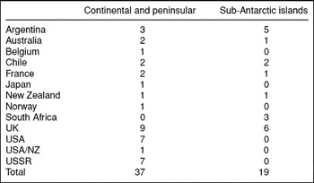
Estimates of the total number of persons involved worldwide in IGY networks usually give a figure of approximately 60,000, of whom 10,000 were scientists. In the Arctic more than 300 stations were established by 14 northern and other nations interested in that region. Antarctic and sub-Antarctic islands counted for some 68 stations mainly manned by personnel from the 12 nations that had research programmes there (see Table 3) (Sullivan Reference Sullivan1961; Wilson Reference Wilson1961; Walton Reference Walton1987).
Table 3. Numbers of IGY stations (and affiliation) in the Antarctic.

Estimates of the number of stations vary, the table is based on a similar one in J.T. Wilson Reference Wilson1961; see also Walton (Reference Walton1987: 55). For the names of stations see Summerhayes (Reference Summerhayes2008).
In terms of the science generally there was far greater differentiation than before in terms of disciplines and research specialties with glaciology, for example, coming into its own. Major foci for research were outer space, the ionosphere, the magnetosphere, the cryosphere, the oceans and the crust. Special scientific and technical panels were set up to cover the following geophysical fields: auroras, airglow, cosmic rays, geomagnetism, glaciology, gravity, ionospheric physics, longitude and latitude determinations, meteorology, oceanography, rocket exploration of the upper atmosphere, seismology, and solar activity. Incidental to the official programme some researchers also did work in geology, biology and human physiology.
Geopolitics and an Antarctic focus
The legacy of World War II was an important factor here, comprising three aspects. Firstly, great advances had been made in radio communications, aircraft transportation, radar, and the development of motorised track vehicles that were used for overland travel and use on scientific traverses in Antarctica. Secondly, radar, rockets and computers afforded new tools for researchers, not least for probing space in auroral latitudes. Thirdly, as already noted, the post war geopolitical situation was dominated by the cold war, a situation in which science became important for both military prowess and diplomacy. In the Antarctic, in particular, geopolitical rivalry was translated into scientific competition and co-operation: a sublimation of politics in science (Elzinga Reference Elzinga, Svedin and Anisansson1992, in press a). Under the auspices of the IGY geophysical work in Antarctica was therefore a major focal point (for overviews see Robin Reference Robin1961; NAS 1961a).
During the austral summer about 5000 persons were on active duty in the region, a figure that fell to just over 900 in the Antarctic winter. Table 3 indicates how the USA and USSR were the biggest participants. The USA feat of putting a research station at the geographic South Pole was matched by the Soviet placement of a station at the pole of inaccessibility (Petrov Reference Petrov1957; Bulkeley Reference Bulkeley2008). Simultaneously research vessels plied the oceans to map the circulation of currents, take water temperatures at various depths, probe sea beds taking bottom cores, and making rock dredges, etc.
New technologies, instruments and scientific avenues
A dramatic event was the launch of the Soviet artificial satellite, Sputnik, the first man made construction to circle the Earth in 1957 (Wilson Reference Wilson1961). The first USA satellites into space in 1958, (Explorer 1 and 3), were fitted with Geiger counters and able to discover the radiation belts around the earth, later named after James van Allen (Berkner and Odishaw Reference Berkner and Odishaw1961). Systematic visual studies of aurora in north and south as well as recordings by all sky aurora cameras (a new instrument) in various locations including Antarctica led to the finding that aurora occur in the same hour in both hemispheres at conjugate points (locations in opposite hemispheres where a specific line of magnetic force intersects the Earth's surface). Stimulated by the construction of the DEW line that was finished in 1958 (Dansgaard Reference Dansgaard2004), the US Air Force boosted radio physics at several universities in the US, Canada, Denmark, Sweden and some other countries (Smith-Rose Reference Smith-Rose1963).
One of the more sensational events in Antarctica was the traverse by the British scientist Vivian Fuchs’ party (on the Commonwealth Trans-Antarctic Expedition) from the Weddell Sea via the South Pole to McMurdo Sound on the Ross Sea (Fuchs and Hillary Reference Fuchs and Hillary1958). During the traverse seismological soundings were made to determine the depth of the ice cap. Seismology and gravity measurements were also undertaken during a series of separate traverses by US, Soviet, French, and Australian scientists.
Such traverses supplied completely new information on the profiles of ice sheet thickness, the configuration of underlying bedrock surfaces, and gravitometric data. Earlier the ice thickness was held to range from 600 to 1600 m. Now scientists discovered thicknesses of over 4000 m and an average ice sheet thickness of over 2000 m. Even if such findings were later revised they nevertheless led to radical recalculation of the total ice volume over Antarctica. Supplemented by aerial surveys and reconnaissance the traverses also gave data that led to better maps of the Antarctic interior, recording new features like mountain ranges and ice free ‘oases’ additional to those known before. They also added credence to the concept that three quarters of Antarctica is continental in character and that it was not just a string of sub-Antarctic islands along the polar circle. Connected to the continent is an archipelago under the ice of the Antarctic Peninsula. It was found that the hypothetical channel between the Ross and Weddell seas (the Ross-Weddell graben) does not exist, although it was surmised that a subglacial channel probably looped back under Marie Byrd Land into the Bellinghausen Sea. Thanks to incidental geological work a much clearer picture emerged of what then were perceived to be potentially exploitable mineral resources like coal deposits, uranium and other minerals in a number of mountain outcrops. Uranium finds in particular made newspaper headlines and spurred speculation across the world.
History and shape of the Earth
Research during the IGY also provided evidence favourable to the long disputed hypothesis of continental drift and the theory of plate tectonics, forming our present day understanding of the origin of the Earth's oceans and continents. Monitoring of earthquakes combined with gravity measurements (Belgian, French, Soviet, UK, USA in the Antarctic) provided data that helped confirm the existence of the hypothetical proto-continent Gondwanaland in a geological past. As one leading geologist put it later, ‘because of its central position in the reassembly, Antarctica clearly must play an important role in determining the reality and history of Gondwanaland’ (Craddock Reference Craddock and Craddock1982: 3; see also Fütterer and others Reference Fütterer, Damaske, Keinschmidt, Miller and Tessensohn2006). Oceanographic work and seismic crustal studies (US and Argentina) around the Falkland Islands and southward provided further insight into the character of the submerged Scotia Arc extension of the Andes. It should be noted however that gravity measurements around the globe were made on different standards and were not tied together in a unified network.
Analysis of perturbations of IGY satellite orbits indicated that the degree of polar flattening of the Earth was less than previously estimated, and that there was a geoidal bulge in the Arctic polar area and a depressed region in the Antarctic. Consequently, the Earth's shape does not conform to that of an ideal rotating fluid body. Such findings spurred later research on more precise determination of gravitational anomalies.
Atmospheric and cryospheric processes
Global meteorological data led to a more distinct delineation of the earth's stratosphere and its difference from the other levels of atmosphere. Total radiation and energy budget calculations improved, and so did the ability to produce weather forecasts, including for the first time also for parts of Antarctica. Meteorologists were able to reveal important features of the thermal structure and circulation of the atmosphere over the Antarctic continent and nearby oceans. Over the Antarctic reversals in stratospheric winds from summer easterly to winter westerly were found to be very regular and to move southward and downward from 40 km at high latitudes. It was found that while local atmospheric vortices tend to pass in and out of Antarctica there is a single large vortex centred on the polar plateau and surrounded by a circumpolar ‘jet stream’. The air at the centre of the vortex becomes steadily colder and sinks, generating drainage (katabatic) winds that move over glaciers towards the continental periphery, sometimes with fierce blizzards. Further understanding was thus gained of the katabatic airflow that is one of the most prominent meteorological features in Antarctica.
It was furthermore suggested that the continental existence of Greenland and Antarctic icecaps is due to their being ‘protected’ by the oceans, in the absence of which lower albedo and hence higher heat ‘consumption’ would exist. An important series of charts from the IGY came from the international Antarctic weather centre at Little America V to which all nations sent regular data sets. This was an early first step on the road to a better understanding of the Antarctic atmosphere its various trends, and its place in world weather. An unexpected finding was that the lowest temperatures are not found at the geographic South Pole but at positions on the plateau, where elevations above sea level are higher than the 2800 m recorded at the pole.
Glaciological research in Antarctica was initially meant to supply knowledge of the physical properties of ice sheets with an eye to their influence on the atmospheric environment and climatic conditions. Overall, the Antarctic ice sheet was estimated to cover seven times the area of the Greenland ice cap, and about the same size as the Laurentide ice sheet that covered a large part of Canada and the USA about 95,000 to 20,000 years before present day. As already noted, radical new estimates were made of the ice volume in Antarctica and consequently on the earth's surface as a whole. Experiments were made with radio waves to measure the ice thickness of ice shelves, a technique that later led to ground penetrating radar widely used in aerial surveys over vast areas of Antarctica from the 1970s onward. The IGY made possible for the first time a coordinated international plan to study Antarctic glaciology (Light Reference Light1966). Experience was gained for the first time of deep core drilling down to 300 m in the Ross Sea ice shelf and in the inland ice, largely due to USA and Soviet efforts, respectively, a prelude to later ice coring projects now so important in climatology (Dansgaard Reference Dansgaard2004; Langway Reference Langway2008; Elzinga in press b)
The world's oceans
In oceanography, many countries participated in mapping seasonal changes in ocean masses caused by redistribution of water within the oceans and between sea and land. Conductivity salinometers were only just becoming available in 1958, so that the overwhelming majority of salinity results were still determined by titration. Careful studies of density-salinity relationships and temperature gradients along various levels down into deep waters however enabled determination of continuous profiles. Major operations also explored the bottom contours of the north and south Pacific, the Indian Ocean, and the Atlantic, and ocean circulation on all parts of the globe (Wexler Reference Wexler and Bolin1959; Wilson Reference Wilson1961: 259; Doel Reference Doel2003). Some missions were secret since they were involved in assessing radiation in the atmosphere and geochemical effects in ocean waters worldwide in connection with USA atomic tests in the Pacific and Soviet tests in the Arctic (Doel Reference Doel2003). In 1958, the US Navy sponsored initiatives in underwater sound transmissions and target tracking to develop an ocean surveillance system, an analogue of the DEW line on land. US and Soviet submarine exercises led to much valuable data about ice conditions and bottom topography that have only been declassified since the mid 1990s.
In the Arctic regions the International Council for Exploration of the Seas (ICES, established 1902 in Copenhagen), co-ordinated a major programme called the Atlantic polar front survey. It covered a vast area from Novaya Zemlya to Svalbard and to the Grand Banks of Newfoundland (Dietrich Reference Dietrich1969). A prediction of a southward flowing westerly boundary current below 2000 m was partly verified, and a conclusion was that earlier ideas about the general circulation of the north Atlantic would have to be revised. Information about equatorial undercurrents obtained by other expeditions also brought new information, adding to new and perplexing questions that were only answerable much later (for example the El Niño phenomenon).
Another aspect of research in Arctic waters relates to the drifting ice islands, of which the USA and the USSR had two each during the IGY (Wilson Reference Wilson1961: 159). Soviet scientists operated such stations since 1937 (Laktionov Reference Laktionov1960; Althoff Reference Althoff2007). They had made the remarkable discovery of the Lomonosov Ridge that was also the object of further studies during the IGY (National Academy of Sciences 1961b). In the Antarctic region the Soviets dominated in oceanography. This was because they had two vessels Ob and Lena with excellent ice-forcing capabilities and adequately staffed to operate continuously in the Antarctic. A close network of cooperating oceanographic stations to study the fine structure of the Antarctic convergence was lacking. The Soviets, guided by broad oceanographic problems and building on H.U. Sverdrup's classical work of 1942 and earlier, and using a more systematic database succeeded in finding a justification for the theory that the southern circumpolar water can be considered as an independent southern ocean.
Incidental biological studies
Most Antarctic expeditions made marine collections incidental to their main purpose, for example in connection with chemical and oceanographic surveys on the US Navy icebreakers operating during the IGY (NAS 1961a). Therefore, despite the large number of expeditions, the collections from areas around the Antarctic continent for the most part were haphazard and relatively small. An exception was the work of Soviet scientists. As the research vessel Ob also had extensive collecting and laboratory facilities for marine biological research, the Soviets were also able to undertake the most intensive programme of all nations in the study of Antarctic fishes, collecting specimens from two meridian sections across the Indian Ocean and from the Antarctic and sub-Antarctic. Fish collections were obtained by mid water tow nets, trawling at 1000–3000 m depths, hook and line fishing along the Antarctic coast, and examination of seal stomachs. Many rare species were recorded, including new ‘white blooded’ ones. Soviet scientists also brought back 600 ornithological collections representative of 11 species of birds. Scientists from several countries made inventories of fauna on Antarctica and sub-Antarctic Islands. Otherwise, ornithological collections and studies were few and far between. An exception was the work of a scientist who was able to organise a skua investigation involving eight nations and eighteen Antarctic stations (Eklund Reference Eklund1959). Studies on penguins and snow petrels were carried out at various stations, but more sporadically.
Institutionalising new epistemic and political regimes for Antarctica
From the foregoing review of some of the accomplishments during the IGY it is clear that research was epistemologically more diverse and problem oriented than in the second IPY while the theoretical foundations had grown immensely. IGY started a trend in which even Antarctic geology ‘became less historical and descriptive and more explanatory’ (Fogg Reference Fogg1992: 260). Many new hypotheses were developed and in some cases confirmed and many questions emerged regarding various geophysical dimensions of the Earth. The focus had shifted to a more process oriented approach with attempts to construct models of atmospheric and oceanic circulation processes. Ionospheric and cosmic studies apart from benefiting from more advanced probing techniques had also gained a more solid theoretical footing with sophisticated mathematical models of the magnetosphere and solar winds. At the same time empirical work of data collection and monitoring continued and provided benchmarks for model construction. Furthermore, developments in computer aided methods of numerical analysis with the move from analogical to digitalised simulation models helped open many new avenues of research.
One of the most important outcomes of the IGY was at the political level, the crafting of the Antarctic Treaty of 1959 and its adoption by the twelve founding nations in 1961 (Laclavére Reference Laclavére1961). The treaty provided a special regime for intergovernmental cooperation in which science was the entry token for a country's participation in guiding the management of the continent's future. In the landscape of polar research the creation of SCAR after a conference in Stockholm 1957, first as the Special Committee on Antarctic Research, and then in 1961 as the Scientific Committee on Antarctic Research (Elzinga Reference Elzinga2007: 155–157) finally provided the kind of stable and commonly accepted international institutional base that the frustrated forward looking architects of the short lived IPC of 1913 would have envied. In short, SCAR and the Antarctic Treaty together became the foundational pillars in the further ‘construction of a continent by and for science’ (Elzinga Reference Elzinga, Crawford, Shinn and Sörlin1993a; Elzinga Reference Elzinga1993b; see also Lewis and Smith Reference Lewis and Smith1973). Within the IGY three world data centres were created to assemble data in all branches of geophysics (Wilson Reference Wilson1961: 33), records some of which are still used today for example in global climate change research.
Historic challenges of the 1970s and 1980s and SCAR's response
In order to understand the developments leading to the new IPY, it is necessary to appreciate the function of SCAR and its expanding role in the face of a number of challenges stemming from changes in both the geopolitical arena and science during the period following the IGY. Particularly important were five factors: pressures deriving from a world process of decolonisation, the rise of environmentalism, new technologies, as well as calls for both interdisciplinarity and stronger societal relevance. It is pertinent here to indicate briefly how SCAR adapted to these changing political, technological and conceptual developments that over the past fifty years have culminated in the situation we have today, with a new polar year.
After the IGY, SCAR served as the international organisation responsible for contacts, coordination and initiatives in Antarctic science. Though formally independent and at arm's length with regard to the Antarctic treaty system (ATS), it was instrumental in advising politicians in the face of mounting external and mutually contradictory pressures (Elzinga and Bohlin Reference Elzinga and Bohlin1989). During the 1970s and 1980s, with growing environmental consciousness, a large number of international scientific programmes were created under the auspices of ICSU and the WMO. Thereby the problems and agendas of polar research in Antarctica were also reframed.
In the 1980s the ATS was under pressure when the movement of non aligned nations led by Malaysia on the one hand and international environmental movements on the other hand questioned the closed character of a regime dominated by rich industrial countries in ‘the north’. Two alternative regime concepts emerged to challenge the ATS, one of them suggested that whatever wealth might be found in Antarctica should be a ‘common heritage’ to benefit all nations, the other that the continent should be transformed into a world wilderness park with an emphasis on its pristine environmental and aesthetic qualities. The butt of this opposition was broken when India, China and Brazil came into the ATS (see Elzinga Reference Elzinga, Crawford, Shinn and Sörlin1993a: 76–79).
In view of the pressure of new countries knocking on the door and the challenge of environmental issues, SCAR too had to redefine its lead role under new conditions (see Elzinga Reference Elzinga1993b). The organisation was drawn more tightly into the ATS when the consultative parties to the treaty in 1985 made a decision that called upon SCAR to provide the governing body with regular reports on its activities, signalling a wish for a greater degree of accountability and transparency (Berguño in press). Soon thereafter SCAR's executive initiated a strategy discussion to articulate both traditional and new goals, which was followed by some reorganisation and the creation of new groups of specialists, conscious efforts to increase SCAR's visibility and a clearer task differentiation. An evaluation of SCAR initiated by ICSU in 1991 took stock of these developments and made some further recommendations, for example underlining the importance of the organisation's quality enhancement function in fields of Antarctic science (Colwell Reference Colwell and Elzinga1993). Quality control was an issue raised in the late 1980s by, among others, David Drewry, then director of the British Antarctic Survey and chairman of a new organisation, the council of managers of national Antarctic programmes (COMNAP). In a critical note in a guest editorial in the then newly founded journal Antarctic Science, he explicitly criticised a limited parochial inductivist ideal of science that had existed in polar science for a long time, writing: ‘[f]or too long Antarctic sciences have been directed towards cognoscenti, producing at times a lobotomized scientific output in which special symposia volumes at best, and national scientific reports at worst, unreviewed, lacking critical impact and elevating the trivial, have been a substitute for rigorous assessment of methodology, measurement and full exposure to the judgements of the international scientific community’ (Drewry Reference Drewry1989: 2).
SCAR research strategy; inter and multi-disciplinarity and the concept of ‘the systemic’
The strategy discussion was formally triggered in 1987 when SCAR president Claude Lorius expressed concern at the growing pressures on SCAR from other organisations and believed that SCAR would need to make a conscious decision on the extent of its international role or whether it should retain a low profile as stated in the introduction to its constitution. The first option was decided upon. A statement by the SCAR executive committee reflects how this organisation began to reposition itself in order to relate more actively to the ‘holistic’ trends of the times. ‘Because of the changing emphasis to contributions to major global programmes and growing emphasis on resource issues and environmental questions, the SCAR executive is convinced that it is now timely to begin careful review of SCAR function and strategy’ (SCAR 1988: 265). The rationale was that as science ‘is now studying continent-wide processes on a much larger scale than previously, it is becoming increasingly concerned with interdisciplinary and multidisciplinary problems, and more and more it is becoming important to Antarctic science to make significant contributions to the growing number of international programmes studying global physical, geophysical and biological processes’ (SCAR 1991). Antarctic science, it was maintained, had a new critical role extending far beyond the Antarctic, especially to understand the interactive physical, chemical and biological processes that regulate ‘the total Earth system’.
The reassessment of SCAR's role at the time is interesting in the way it reflects a number of epistemological characteristics and trends that are now clearly entrenched in the programmes of the fourth IPY: inter- and multi-disciplinarity as well as a process of globalisation that manifests itself at organisational, cognitive and policy levels. At the cognitive level we have scientific practices in various countries being linked together in transnational programmes to define problems and conceptual frameworks in terms of what for the moment is taken to be the international research front in a given field. Increasingly Antarctic processes have come to be interpreted with the help of global models. Thus common approaches have been developed across disciplinary boundaries to focus on the atmosphere, ocean circulation, cryosphere, biosphere, geosphere and lithosphere, etc of our planet. This Earth system science approach was successively articulated by SCAR during the 1990s. The conceptual trajectory may be further traced in a series of documents where it is spelled out (for example SCAR 1989 and 1992).
The pressure to develop SCAR in the new directions requiring a strong interplay between disciplines, a holistic interactive perspective, greater coherence, and a more proactive role involving further orientation towards environmental problems and monitoring did not sit well with the way in which SCAR was structured. Consequently SCAR invited an external panel of experts to review its performance. The evaluation that was carried out in the year 2000 led to a major reorganisation and the development of a strategic plan for 2004–2010 (see SCAR 2004). Thanks to the successive adaptation to new realities and the adoption of a more proactive stance SCAR was relatively well equipped when the time came to mantle its role as a lead organisation in the fourth polar year.
The fourth International Polar Year
Fifty years after the IGY the time was ripe for a fourth polar year. Although initially called the International Polar Year 2007–2008, in practice it has came to cover two full annual cycles from March 2007 to March 2009. This IPY is jointly sponsored by ICSU and the WMO (ICSU/WMO 2007). Within the former body SCAR now has a sister organisation, the International Arctic Science Committee (IASC), established in 1990. Together these two organizations hold joint open science conferences.
End of the cold war and a new era of in the Arctic
The collapse of the Soviet Union in 1991 marked the beginning of the post cold war era. In the power vacuum that emerged at first, many entrepreneurial ventures blossomed which radically reformed east-west relations. Most dramatic perhaps was the swift entry of market capitalism, but also there was a rapid development of networks in the sphere of non-government actors, with science and environmentalism topping the list. As time went on new intergovernmental organisations also came onto the scene, one of the most important being the Arctic Council (AC), a high level forum formed on Canada's initiative in 1996 which gave governments a way of reasserting their control over Arctic cooperation (Nilsson Reference Nilsson2007). At first the issue of climate change did not figure prominently on the Arctic political agenda, but this changed in the late 1990s thanks to pressure from various movements and particularly the voices of scientists. New modes of governance had to be found at various levels to balance corporate interests and those of governments regarding economic development based on extraction of natural resources with environmental protection and long term stewardship of Arctic riches, taking into account the demands of indigenous peoples that in some cases also had formed strong lobbies. The Inuit Circumpolar Conference formed in 1977 representing six indigenous communities also gained more leverage by permanent participation as observers at the AC.
Today, outside the IPY framework large icebreakers are traversing the Arctic seabed in a race for riches. Multinational corporations are standing in the wings. These activities that involve geoscientists are generating headlines with speculations about a rush for dark gold and an ‘energy cold war’; there are estimates that almost one quarter of the world's untapped hydrocarbon reserves exist under the Arctic Ocean (Edmonton Journal 15 August 2008; also see Dodds Reference Dodds2008). Seabed mapping along the Lomonosov and Alpha ridges is particularly contentious because it raises jurisdictional issues relating to national sovereignty claims since the contours of 200 mile economic zones beyond claimant nations’ continental shelves are rather diffuse and contested. A small grey zone sector of the Beaufort Sea is claimed both by Canada and the U.S. The lines defining the Arctic Ocean commons around the geographic North Pole are in flux.
Signs of what was to come were there in 1986 when President Mikhail Gorbachev unleashed his Glasnost and Perestroika movement. His speech in Murmansk in October 1987 is often taken as the turning point since it made reference to the possibility of establishing a programme for pan-Arctic co-operation covering resource development, environmental protection, the opening up of sea routes, a recognition of the rights of indigenous peoples, and not least, science. His concept of the ‘Arctic’ went beyond the earlier notion of Arctic rim states in a way that in principle allowed the non-rim states Finland, Iceland and Sweden to enter into the new forms of co-operation (for example the Arctic Council). An immediate effect was the definition of a broad ‘Barents region’ spanning several national boundaries as a political framework for regional economic development. This was stepped up in 1993 by the formation of the Barents-Euro Arctic Council with Norway, Sweden, Finland, Russia and the EU as members to drive the process. Later, additional countries joined the effort.
On the research front, in 1990, IASC, the Arctic equivalent to SCAR was created as an international associate of ICSU. It currently has 18 member countries and seeks to encourage and facilitate co-operation in all aspects of Arctic research including social and cultural sciences. The same year the International Arctic Social Sciences Association (IASSA) was founded. It brings together researchers in archaeology, history, economics, ethnography, human ecology, social anthropology, political science, gender studies and several other fields. In 1992 an organisation with roots going back to 1986 was formally founded, the North Atlantic Biocultural Organization (NABO). It is known for its excavations and studies of the material culture of north Atlantic island settlements and other remains from Viking times and participates in the IPY with a project on long term human ecodynamics in the Norse Atlantic. Polar archaeologists are also active in the recently formed Polar Archaeology Network (PAN). These and numerous other research networks are very active in the current IPY.
Impacts of environmental concerns, climate change and information technologies
Soon after its formation the IASC identified climate impact studies as a priority. When the human dimension became more visible in the Intergovernmental Panel for Climate Change (IPCC) review of 1997 the idea of launching a comprehensive Arctic climate impact assessment gained credence in political circles. IASC continued to develop a scientific plan for the process that was accepted by the AC in 2000. Not only changes in the physical and biological environment of the Arctic region, but also the impact of climate change on human communities and economic activities, for example oil and gas extraction were to be covered, and it was agreed that indigenous peoples’ perceptions, knowledge and observations on climate change and related issues should be incorporated. The existence of a politics involved in the shaping of climate impact assessments became evident (Nilsson Reference Nilsson2007). The outcome of the assessment was a formidable statement synthesised in a 140 page report (ACIA 2004) that drew much media attention when it was released, while a further report spelled out policy recommendations. Behind it stood a 1042 page scientific report, with over 300 contributors, published the following year (ACIA 2005).
The European Union too is an important actor in Arctic research as witnessed for example by the consortium of 12 European nations that have funding through the framework programme mechanism to develop Arctic modelling and observation capabilities under the acronym DAMOCLES (Developing Arctic modelling and observing capabilities for long term environment studies). The object is to determine processes responsible for present variability and changes in the Arctic climate system and to enhance capabilities to predict extreme climate events and their consequences for the future, for example the disappearance of the Arctic sea ice.
The fourth IPY is still in process and of course it is impossible to write the history of something that still continues. In the text below an attempt is made to highlight some aspects and trends that distinguish this IPY from the previous polar years. Like the contextualisation presented in the foregoing paragraphs the brief sketch below is incomplete. The main point is to indicate how the end of the cold war has opened new circumstances for international scientific co-operation and why the Arctic has come to figure so centrally in the current worldwide exercise. A further point, to be elaborated in the final part of this section, concerns the combination of two additional factors that are important, the environmental change that has already been mentioned, and the entry of information technologies and the role of high power computers in research. Together these two factors contribute to a development in which the Arctic and Antarctic, conceptually and through modelling, are now integral parts of an Earth system science. The process leading up to this latest epistemic twist, as already noted above, posed a challenge for SCAR, an organisation that was created in the period following the IGY when knowledge was mostly packaged in disciplines. The IASC, being a relatively young organisation that has grown up during the 1990s, does not appear to have had the same difficulties.
Structuring research around themes instead of disciplines
Involved in the present IPY are some 50,000 scientists, engineers and other persons from 63 countries (31 of them with own national committees). The scope has been expanded from geophysical dimensions to include biology and also social sciences and humanities. Primary geophysical focal points are environment, climate change, biodiversity, and fundamental geophysical processes in complex interaction. The overall effort is no longer structured along disciplinary boundaries but rather organised around six scientific themes: (1) the present status of various ‘systems’; (2) mapping and understanding systemic changes, past, present and future; (3) advancing understanding of linkages and interactions at all levels; (4) new frontiers of polar research; (5) probing planetary processes like solar terrestrial interactions, etc; (6) the human dimension. The sixth area only came into the picture in its own right at a late hour. Initially social scientists experienced some resistance to such a focus, in the sense that many natural scientists seemed to think the ‘human dimension’ could be incorporated as a kind of ‘add-on’, factor to complement a predominantly scientific approach, thus a token acceptance. Some natural scientists for their part maybe feared that leading representatives of the ‘soft’ sciences were trying to lay hands on too much of the funding from national research councils. The discussion came to a head at the Open Science Conference in Bremen, Germany, July 2004, at which Louwrens Hacquebord on behalf of the IASC, as well as several other conference participants, the present author included, argued strongly for recognition of a social and cultural sciences component in the IPY on equal terms, which ultimately led to inclusion of a separate sixth theme.
Altogether, of the 228 endorsed projects included under the current polar year 119 have an Arctic focus while 39 are Antarctic projects. The remaining ones have an explicit bipolar comparative approach. Further features that are new include: a highly visible participation of women in science, a mentoring system for early career scientists, major emphasis on outreach and education (57 projects) to inform a wide range of audiences through media, special events in schools, cultural programmes, museum and other exhibits, university courses, initiatives to involve polar communities and much more. The issue of the legacy of the present IPY has also received considerable attention, with systematic measures being undertaken to ensure comprehensive databases, observing systems, data management systems, geobrowsers and related infrastructures to facilitate follow up in the form of analyses, visualisation, and publishing.
Not all of the projects endorsed have received funding from national research councils and the like, but nevertheless the numerical proportions of the projects give an indication of the very strong focus on the Arctic region, which in turn confirms the appreciable shift of attention in this direction after the end of the cold war. Multidisciplinary marine expeditions have been conducted in the Arctic Ocean, with four major projects run by Canada, the EU, Russia and the USA, respectively. Oceanic processes, sea ice properties and changes, physical and chemical interaction between atmospheric conditions, sea ice and ocean, as well as marine geology and biology are central topics. A large number of new under ice mobile observing facilities was employed.
A similar survey was carried out in the Antarctic and the southern ocean. Ecological systems and biodiversity are also important topics in terrestrial studies, north as well as south, as are the dynamics of glaciers and ice sheets. In the north, research on permafrost and the hydrological cycle, moreover, has direct relevance for questions relating to the sustainability of ecosystems and circumpolar human societies, given the changes associated with global climate change as witnessed by the increased disappearance of Arctic sea ice in summer. The latter phenomenon and its consequences for human and animal life in the Arctic region is the topic of DAMOCLES, already mentioned above. The warming of Siberia, the melting of permafrost in various places in Arctic rim countries, as well as long term consequences for human habitation as solid land turns into slush is also receiving attention.
In the south, the retreat of glaciers on the Antarctic peninsula and the collapse of many of its ice shelves have also generated important studies while a coordinated effort involving many countries concerns long traverses across the Antarctic ice cap with recovery of shallow ice cores and ground penetrating radar surveys to get a better understanding of the varying environmental conditions of the cryosphere over the entire continent. Linking the data accumulated with that from deep ice core drilling at several sites on the continent is also significant for a better understanding of cyclic changes in the palaeoclimates that reach back over hundreds of thousands of years.
Important new knowledge is also being gained about the complex interconnected system of lakes and rivers far beneath the Antarctic ice cap. Further, the enigma of the Gamburtsev mountain range beneath the east Antarctic ice sheet is now being probed. At the South Pole the existence of the driest, cleanest air on the planet is used to advantage by astronomers deploying arrays of telescopes to explore the distant cosmos.
Since it is new in polar research, the human dimension should be specially highlighted. The history of polar research has, for example, become a component. A SCAR standing group for the history of Antarctic science has been created but unfortunately, the main project planned by this group did not receive funding from national sources. Nevertheless the group has been able to conduct four international workshops (see for example http://www.scar.org/about/history/). A special International Polar Heritage Committee (IPHC) is now active in monitoring and publishing attractively designed reports on historical sites like former research stations, whaling stations, mines and other forms of cultural heritage (IPHC 2004). One of the most successful IPY human dimension projects deals with the history of exploitation of natural resources. It has received financial support from the research councils of the Netherlands, Russia, Sweden and the USA. The project's acronym is LASHIPA (Large-scale industrial exploitation of polar areas). The object is to study past settlements and stations (hunting, whaling and research) on the basis of fieldwork on site and archival records as well as old photographs and maps to gain a better understanding of natural resource exploitation in polar regions, north and south in a comparative international perspective (see http://www.lashipa.nl/).
New technology has transformed research practices
Since the time of the IGY, modes of transportation have changed drastically and so has the wide range of instruments available to the researcher. Computer power is enormous and a network of satellites with remote sensing capabilities produces data about conditions on the Earth. Specialised databases and the internet facilitate easy access to data and publications from all parts of the world; an aspect that was problematic in the first two polar years and to some extent after IGY. Geophysical positioning (GPS) devices are in use as invaluable navigational aids and research tools in the field. Specialties like GIS and geoinformatics are integrated parts of the earth sciences. Satellite telephones afford instant communication between observers in the field and with home country offices and laboratories. Visualisation technologies permit entirely new ways of analysing data, interpretation and modelling, as well as constructing representations of complex coupling of different phenomena.
Conceptually the Antarctic is increasingly being treated as a component in Earth system science (SCAR 2004). Hence bipolarity, that is the linking of the Arctic and Antarctic is a significant feature of the IPY, not only epistemically but also regarding research organisation and programme co-ordination. Politics has driven research agendas into a ‘green’ direction. Now for the first time the human dimension and the local knowledge of the people living in polar regions are also included in a polar year. Drilling technology has been developed to recover ice cores to a depth of more than 2 km from within the polar icecaps. The icy archives of changing temperatures, greenhouse gases trapped in air bubbles, dust from volcanoes, and much more are made available for analysis. The perspective is bipolar in order to gain a better understanding of glacial and interglacial epochs in the natural history of our planet. All these developments have brought with them cross cutting inter and multi disciplinary approaches in polar science as a part of mainstream science. Indeed Antarctic integrated systems science (AISS) has become a research concept.
Towards an Antarctic integrated system science (AISS)
Under the auspices of the fourth IPY the move towards developing an integrated systems approach has been articulated explicitly by the National Science Foundation (NSF) in the US in terms of setting a course for AISS (NSF 2007). The rationale for an AISS is that ‘cross-cutting scientific questions necessitate resources and talents from multiple disciplines and institutions acting in concert. . . .Scientific questions demand an integrative approach when progress hinges on knowledge and resources that exceed those available within a single discipline’ (NSF 2007: 11). An important tool for cross disciplinary integration along thematic lines is computer aided modelling of complex systems. Computer systems are in a sense used to extend human cognition. They are capable of integrating vast amounts of data and proxy data to simulate virtual scenarios relating to possible future trends in models of physical, ecological, social and other ‘environments’. Analysts aggregate data from relevant systems into more general computer simulation models and their interactions to determine crucial parameters of ‘global change’, and its complex dynamics in order to make predictive assessments that are used for negotiating international regimes to protect our environment and deal with problems of climate change, efforts that in themselves also are relevant for a politics of global dimensions. In creating models of global systemic processes the poles have become an even more integral source of data and concept formation in the broader disciplines: climatology, palaeontology, geology, geophysics, biology and physical oceanography. In effect, SCAR's strategy today is implementing a version of NSF's proposed AISS.
New computer based, systemic, realist constructivism and predictive capacities
In as far as the construction of simulation models involves a variety of methodological decisions for purposes of simplification, epistemologically speaking it introduces an element of realist constructivism in present day production of polar science. Different types of uncertainty must also be taken into account, natural as well as epistemic uncertainties. Computer based visualisation technologies facilitate new modes of data transcription and representation of scientific objects, which in turn has a bearing on concept formation, the framing of hypotheses, and the construction of models and theories. When all these features are taken together, computer based simulation, emphasis on the ‘systemic’ and the goal of predicting future trends in the complex systems studied, polar research today may said to encompass an epistemology that is at once systemic, constructivist and predictive, thus distinguishing it from more traditional hypothesis and data driven approaches of the second polar year and IGY, respectively. As in other fields of science data and technology driven ‘inductive’ advances have become complementary and iterative partners with hypothesis led studies in entirely new ways (Smalheiser Reference Smalheiser2002; Kell and Oliver Reference Kell and Oliver2003; Wiley Reference Wiley2008). Some philosophers of science argue that computer based research and simulation radically transform traditional modes of scientific knowledge production and evaluation. They point particularly to meteorology and climate research as examples and ask if what we are seeing is a major ‘epistemic shift’, that is, a shift in the ways we know (Gramelsberger Reference Gramelsberger, Mayntz, Neidhardt, Weingart and Wengenroth2008). From the point of view of history and philosophy of science it is interesting to try and delineate more precisely the ‘epistemic shift’ here indicated.
Concluding remarks
Taking a long term historical perspective with the four polar years as lenses the present paper suggests that each of the four IPYs has its own characteristic epistemology or mix of epistemologies. These range from the early inductivist approach of the late 19th century to an increasingly hypothesis driven one emerging in the 1920s and 30s that blossomed in the process oriented mode of the IGY. The advent of the Antarctic Treaty and the formation of SCAR, introduced a sustainable platform for Antarctic science. This regime allowed for constructive interplay between research and politics embodied in parallel non governmental and intergovernmental arenas of decision making. Making science the token for membership in the ‘Antarctic club’ turned out to be fruitful for the countries and the scientific communities involved, but it did not go unchallenged. In response to new political and scientific challenges of the 1970s and 1980s the structure and function of SCAR as a lead agency in the realm of science was transformed, and its visibility greatly enhanced.
With the geopolitical thawing process and the end of the cold war preconditions for co-ordination and co-operation in science relating to the Arctic region changed radically. Gorbachev's Murmansk speech in 1987 signalled a turning point and it was possible to set up the IASC as a sister organisation to SCAR. At the political level the AC was created with ambitions of introducing a form of intergovernmental governance. Hitherto, however, it has not been possible to forge a political regime for the Arctic Ocean system patterned on something similar to the Antarctic Treaty system. During the past decade strong interests in exploiting Arctic resources have generated many tensions that are difficult to bridge over. At the same time the shift of attention to the Arctic region is reflected in the orientation of the current polar year in which a majority of projects address problems in the domains of the geophysical, biological, ecological, but also the social and cultural sciences. IASC, together with the AC, has also been centrally involved in the production of an important environmental impact assessment. Being a comparatively young organisation the IASC has not experienced the same difficulties as SCAR of having to restructure since it already at the outset organised itself along thematic interdisciplinary and systems oriented lines.
In the post cold war period remarkable new changes have taken place in the conditions of research. A duality of policy related and cognitive reorientations together with new research technologies continued to influence both empirical and theoretical work. There was a proliferation of major international scientific programmes, among others in the fields of environment and climate, and a rapid development of powerful new tools in the form of computer aided data collection, research, simulation and evaluation. Both these trends have contributed to shaping the emergence of a systemic, constructivist, predictive mode of scientific knowledge production that we witness today. Entirely new dimensions have been opened. The new terms integrated Earth system science (IESS) and AISS are cited as symptomatic indicators as we look into the future.
The successive changes focused here though the lens of the four respective polar years should not be seen as successive jumps or breaks but rather as a successive over layering and integration of the earlier approaches by, and into, the later ones.
Acknowledgements
I want to thank the staff and archivists at the Austrian Academy of Sciences in Vienna and the Danish Meteorological Institute as well as the Danish National Archives in Copenhagen for permission to consult archival collections there relating to the first and second IPYs respectively. Cornelia Lüdecke is warmly thanked for many helpful comments when reviewing a draft version of this paper. Thanks to Gustaf Nelhans at my own department for alerting me to several relevant articles on methodology of science discussions past and present. I also wish to record my debt to two anonymous reviewers for their detailed and constructive suggestions for the final revision. Anders Karlqvist, the director of the Swedish Polar Research Secretariat, has also provided valuable comments, as has Rip Bulkeley. Finally, thanks to the Royal Society of Arts and Sciences in Gothenburg for a stipend that allowed me to present an earlier version of the paper in St. Petersburg in the session of the SCAR Action Group for History of Antarctic Science within the Open Science Conference.