Introduction
In 1978, Uffe Petersen of the former Geodetic Institute in Copenhagen sighted an islet north of Kaffeklubben Ø (Johnson, Reference Johnson2011). At that time, it was thought to be the most northern islet on Earth. The position of the islet was determined, and in 1979 it was visited by members of a Sirius sledge patrol and by a geological team. In 1980, it was observed for the last time; during the years following, it was searched for but not found. However, several other islets have been located in the region and it appears that the islets come and go. The islets have therefore been called “flygtige småøer” (literally ‘fleeting islets’) by Dawes (Reference Dawes, Martens, Jensen, Meldgaard and Meltofte2003), “ghost islands” by Johnson (Reference Johnson2011), “the Stray Dog Archipelago” by Shea (Reference Shea2012) and “islands on the move” by Dawes and Lautrup (Reference Dawes and Lautrup2017). Dennis Schmitt noted that they behave like phantoms (Burress, Reference Burress2004).
One may wonder if the islets are merely accumulations of sand, gravel and stones on floating sea ice. An ice floe covered by till or outwash gravel, with a small breeding colony of ivory gulls, was reported from North Greenland by Boertmann, Olsen and Gilg (Reference Boertmann, Olsen and Gilg2010). This ice floe was fairly thick and likely represented a tabular iceberg. Ice islands (tabular icebergs) in the Arctic Ocean may carry mineral-rich accumulations with living and even flowering plants (Hultén, Reference Hultén1962). The islets north of Peary Land appear to be real islands that are connected to the sea floor, and the area is probably too shallow for ice islands to enter.
At more southerly latitudes than Peary Land, islands commonly come and go. Waves and currents may, for example, form barrier islands that can disappear during storms and reappear during periods of calmer weather. The north coast of Peary Land is characterised by perennial sea ice and hence negligible wave activity. To the north of the zone with land-fast ice, drifting multiyear pack ice is found in the Arctic Ocean. In the summer, there is often an area of open water at the transition from land-fast ice to moving pack ice (Davies, Reference Davies1972). Davies (Reference Davies1972, plate 2-NE) mapped the area around Kaffeklubben Ø as an area with up to 60% open water, with no icebergs or pressure ridges. To the north is an area with no open water, numerous small pools on ice, closely spaced pressure ridges, followed by an area with summer-open water and finally moving pack ice. As a result of warming in the region, perennial land-fast ice seems to have almost disappeared over the last decade(s) (Danish Meteorological Institute, 2018) during some years.
Northern Peary Land is mountainous, with 500–1856 m high mountains. Along the north coast is a 10–15 km wide, low-lying coastal plain (Figs. 1 & 2). The plain is flat or undulating with ridges in some areas; it rises inland from sea level to c. 200 m and the deposits comprise marine, littoral, fluvial and glacial sediments. The presence of marine and littoral deposits is due to uplift of the region after the last deglaciation. At present, the region is being uplifted by c. 5 mm per year (Wake, Lecavalier, & Bevis, Reference Wake, Lecavalier and Bevis2016); this is due to ongoing melting of glaciers and ice caps. It is likely that a shallow-water area is found offshore, forming a continuation of the plain. No amount of data on the bathymetry of the area adjacent to the coast are available, but Dennis Schmitt noted “In expeditions in this area in 1998-2000, when we walked in open water where there were leads (open water between the coast and the sea ice), water depths increased very little out to several hundred meters (from shore)” (Shea, Reference Shea2012, p. 12).
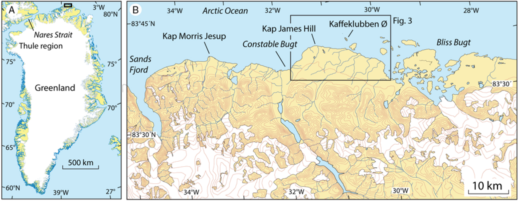
Fig. 1. (A) Map of Greenland showing the position of the discussed region in North Greenland. (B). Map of a portion of northern Peary Land showing the location of Kap Morris Jesup and Kaffeklubben Ø. Contour interval 100 m, note the coastal plain that borders on the Arctic Ocean.
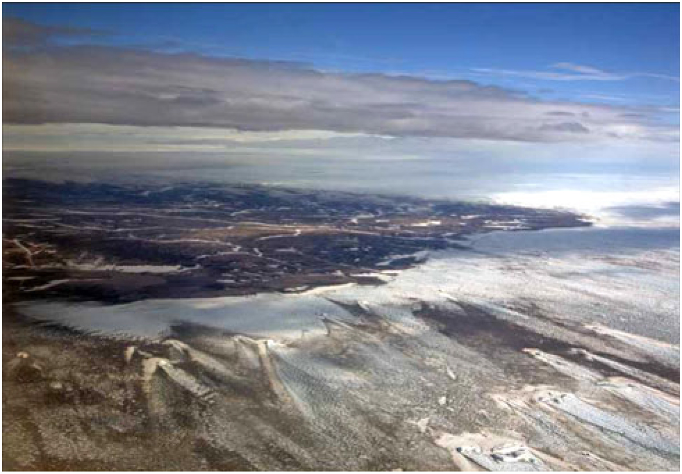
Fig. 2. The northern part of Peary Land is a low-lying plain. The sea adjacent to the land is covered by land-fast ice. Photograph by Jeff Shea.
During the last ice age, glacier ice forming an ice shelf moved along the north coast of Greenland in an eastward direction (Dawes, Reference Dawes1986; Larsen et al., Reference Larsen, Kjær, Funder, Möller, vander Meer, Schomacker, Linge and Darby2010; Fig. 3A); we consider it highly likely that moraine ridges were formed during still-stand periods or re-advances during the overall ice retreat after the Last Glacial Maximum. Kaffeklubben Ø has been interpreted as a moraine ridge formed by a glacier moving north from Peary Land by Davies (Reference Davies1964), but Funder and Hjort (Reference Funder and Hjort1980) and Funder and Larsen (Reference Funder and Larsen1982) suggested that Kaffeklubben Ø and Oodaaq Ø could be remnants of kames. At a later stage during the last deglaciation, glaciolacustrine sediments were deposited in epishelf lakes between an ice shelf to the north and the mountains to the south (Fig. 3B). Local glaciers re-advanced during the Younger Dryas and formed terminal moraines (Larsen et al., Reference Larsen, Funder, Linge, Möller, Schomacker, Fabel, Xu and Kjær2016).

Fig. 3. (A) Conceptual model showing maximum extent of grounded ice sheets during the last glacial maximum. The glacial limit off Svalbard is from Svendsen et al. (Reference Svendsen, Astakhov, Bolshiyanov, Demidov, Dowdeswell, Gataullin, Hjort, Hubberten, Larsen, Mangerud, Melles, Moller, Saarnisto and Siegert1999), off northeast Greenland from Laberg et al. (Reference Laberg, Forwick and Husum2017) and off Canada from England et al., (Reference England, Atkinson, Bednarski, Dyke, Hodgson and O Cofaigh2006). Knies et al. (Reference Knies, Köseoglu, Rise, Baeten, Bellec, Bøe, Klug, Panieri, Jernas and Belt2018) documented that polynyas existed in the northern North Atlantic during the Last Glacial Maximum. Eastward glacial flow directions north of Greenland is suggested by studies of Larsen et al., (Reference Larsen, Kjær, Funder, Möller, vander Meer, Schomacker, Linge and Darby2010). The presence of an ice shelf north of Greenland was first suggested by Dawes (Reference Dawes1986), however, the extent is unknown. (B). During the last deglaciation of the region, glaciolacustrine sediments were deposited between the mountains in the south and shelf ice to the north. The model is based on the work by Larsen et al. (Reference Larsen, Funder, Linge, Möller, Schomacker, Fabel, Xu and Kjær2016). The map is based on the International bathymetric map of the Arctic Ocean (IBCAO; www.ibcao.org; Jakobsson et al., Reference Jakobsson, Mayer, Coakley, Dowdeswell, Forbes, Fridman, Hodnesdal, Noormets, Pedersen, Rebesco, Schenke, Zarayskaya, Accettella, Armstrong, Anderson, Bienhoff, Camerlenghi, Church, Edwards, Gardner, Hall, Hell, Hestvik, Kristoffersen, Marcussen, Mohammad, Mosher, Nghiem, Pedrosa, Travaglini and Weatherall2012).
Some information on visits to the islets can be found on the internet. However, very little data on the islets have been forthcoming, and many internet pages are transitory in nature. We feel that it is necessary to refer to such pages given the lack of other information, but we have also been in contact with a number of people who have kindly provided information for this article. Some of the islets have several names, adding to the confusion about what has been observed where, when and by whom. The dimensions of each of the islets are subject to considerable debate, which may be because no accurate measurements were taken or because parts of the islets were covered by ice or snow at the time of the visit. The aim of this paper is to review the current knowledge status, assemble in an encyclopedic manner what is actually known, and provide a summary of the expeditions that have visited the islets (Table 1). The work is based in part on Dawes (Reference Dawes, Martens, Jensen, Meldgaard and Meltofte2003), Jancik (Reference Jancik2004), Johnson (Reference Johnson2011), Shea (Reference Shea2012) and Dawes and Lautrup (Reference Dawes and Lautrup2017). We find that it is important to document what is known at present, before internet pages with important information are closed down and before people who have visited these islands are no longer with us.
Table 1. Summary of information on islands and islets north of Greenland. Further details are provided in the text.

* Official, authorised names. 11996 American Top of the World Island, 2KMS = Kort & Matrikelstyrelsen Island, 32001 Return to the Top of the World island, 4flyover, 5on satellite images, 6significant sediment found 200 m north of 1997 observation, 7if 2008 Danish team sighting 20 m distant was same as 83-42, 8moraine ridge and/or remnant of kames, 9beach ridge on sublittoral marine sediments, possibly remnants of kames, 10cairn was on the islet when discovered, unexplained.
Early exploration history of the region
The first recorded travel along the north coast of Peary Land was by Robert E. Peary, Matthew Henson and Ahngmalokto in 1900. Peary built a cairn at Kap Morris Jesup and determined its position. The expedition first travelled north towards the North Pole, but was soon stopped by rough ice and open water, so they returned to Kap Morris Jesup. From here, they travelled eastward and thereby established that Greenland is an island. East of Kap Morris Jesup, the expedition saw a small feature, which Peary named Marie Island, after his daughter who was born in Greenland. Although it showed on his field map, the island was not included on the map Peary produced for the US Hydrographic Office in 1903 (Johnson, Reference Johnson2011). Peary probably considered the island too small and insignificant to be included on the map for the Hydrographic Office, or maybe he forgot about it.
In 1909, Donald B. MacMillan, George Borup and five men from the Thule region put out depots along the north coast of Greenland, potentially to be used by Peary on his return journey from the Arctic Ocean. The expedition stayed at Kap Morris Jesup for two weeks, which were spent on measuring the tidal range and water depth as far north as 84°15’N. At that point, c. 70 km north of Kap Morris Jesup, the water depth was only c. 166 m (Borup, Reference Borup1911).
In 1921, geologist Lauge Koch travelled from the Thule region via Nares Strait and along the coast of the Arctic Ocean to Peary Land and back over the Greenland ice sheet, accompanied by the Greenlanders Etukussuk, Inuiterk and Nugapiinguak. The travelled distance was 2900 km and the trip lasted 200 days. From Kap Morris Jesup, Koch continued eastwards and observed an island off the coast. He named the island Kaffeklubben Ø after a coffee club at the Mineralogical Museum at Øster Voldgade 7 in Copenhagen. The informal club was composed of staff members from the former Mineralogical Museum and the former Geological Survey of Denmark. Photographs of the club are published by Garboe (Reference Garboe1961, p. 439) and Rasmussen (Reference Rasmussen1988, p. 18, 19). Koch did not visit the island, perhaps due to inclement weather or because the sledge dogs were in bad shape (Koch, Reference Koch1926) – or perhaps he did not consider it worthwhile to sacrifice precious time visiting the little island, which he probably thought was south of Kap Morris Jesup.
New era – The discovery of features north of Kaffeklubben Ø
On 6 July 1960, the first recorded visit to Kaffeklubben Ø took place by geologists William Davies and Daniel Krinsley from the US Geological Survey, the Danish archaeologist Eigil Knuth and the crew from the two US Army Sikorsky helicopters that were used for transport. The work was part of Operation Groundhog 1960, the aim of which was to locate ice-free areas that could be used as emergency landing sites. Knuth landed on the island at 11:20 and left an hour later at 12:17 (Knuth, Reference Knuth1960). A stone count from Kaffeklubben Ø was published and it was suggested that the island was a terminal moraine (Davies, Reference Davies1964). It is noteworthy that Davies found 50% of red porphyritic andesite, a rock type not recorded from any of his other stone counts from North Greenland. This rock type probably comes from the Kap Washington volcanics that are found c. 70 km to the west of Kaffeklubben Ø.
Davies collected two samples of shells of marine bivalves from raised marine deposits on Kaffeklubben Ø. The ages of the samples were determined by radiocarbon dating to c. 8070 calendar years BP and c. 645 calendar years BP (Ives, Levin, Robinson, & Rubin, Reference Ives, Levin, Robinson and Rubin1964). Another age determination of shells was reported by Funder (Reference Funder1982) based on a sample collected in 1979. The sample yielded an age of c. 8650 calendar years BP. The oldest of these ages provides a minimum age for the last deglaciation of the island.
The 1960 helicopter crew was bored and built a small cairn and left a note in a film canister. The canister with the note was found near the cairn on 6 July 2003 by Peter Skafte, a member of the 2003 Euro-American Expedition (Skafte, Reference Skafte2005b; Johnson, Reference Johnson2011).
In 1991, Kaffeklubben Ø was visited by the Greenlanders Peter (Piitaaraq) Brandt, Kaaleeraq Bech and Johan Brandt, during a trip on skis to the region. Following the trip, the journalist P. Brandt proposed naming the island Inuit Qeqertaat. The name was authorised by the Greenland Place Name Committee on 21 January 1993 (Lisathe Møller, personal communication, 3 September 2018).
In 1969, a Canadian–US team from Project Nord-1969 determined the position of Kap Morris Jesup and Kaffeklubben Ø. They discovered that the northern point of Kaffeklubben Ø is located several hundred metres north of Kap Morris Jesup (Lillestrand, Roots, Niblett, & Weber, Reference Lillestrand, Roots, Niblett and Weber1970; Lillestrand & Johnson, Reference Lillestrand and Johnson1971; Johnson, Reference Johnson2011).
Oodaaq Ø
In the summer of 1978, the Geological Survey of Greenland and the Danish Geodetic Institute began a joint effort to map the geology and topography of eastern North Greenland. On 26 July, Uffe Petersen and Frede Madsen from the Geodetic Institute landed by helicopter on Kaffeklubben Ø to install a Doppler instrument to determine the position of the island by satellite positioning and to do trigonometric measurements. During a break, Uffe Petersen looked to the north and saw a thin shadow. A closer study using binoculars and a theodolite indicated that the shadow consisted of gravel. An account of Uffe Petersen’s discovery is published by Johnson (Reference Johnson2011). Frede Madsen and helicopter pilot Paul Weber from the Swiss company Heliswiss flew to the site, landed and reported that it was indeed an island. Madsen established a geodetic station on the new island, and the distance from Kaffeklubben Ø to the island was measured by an electronic distance measurement instrument (tellurometer) as 1.36 km (Fig. 4). Three days later the Doppler instrument on Kaffeklubben Ø was picked up by Hauge Andersson and Anders Færch-Jensen, also from the Geodetic Institute; the helicopter pilot this time was Urs Stoller from Heliswiss. This group revisited the new island and took some photographs (Fig. 5). The position of the island was determined by theodolite and tellurometer to 83°40’32.51”N, 30°40’10.42”W. On an aerial photograph taken on 23 July 1978, Oodaaq Ø is clearly visible. It appears as a distinct dark spot along the long axis of Kaffeklubben Ø in Route 874B, photograph no. 987. On aerial photographs from 1969, there is a dark area at the position of Oodaaq Ø, but it is impossible to see whether it represents open water or an island.

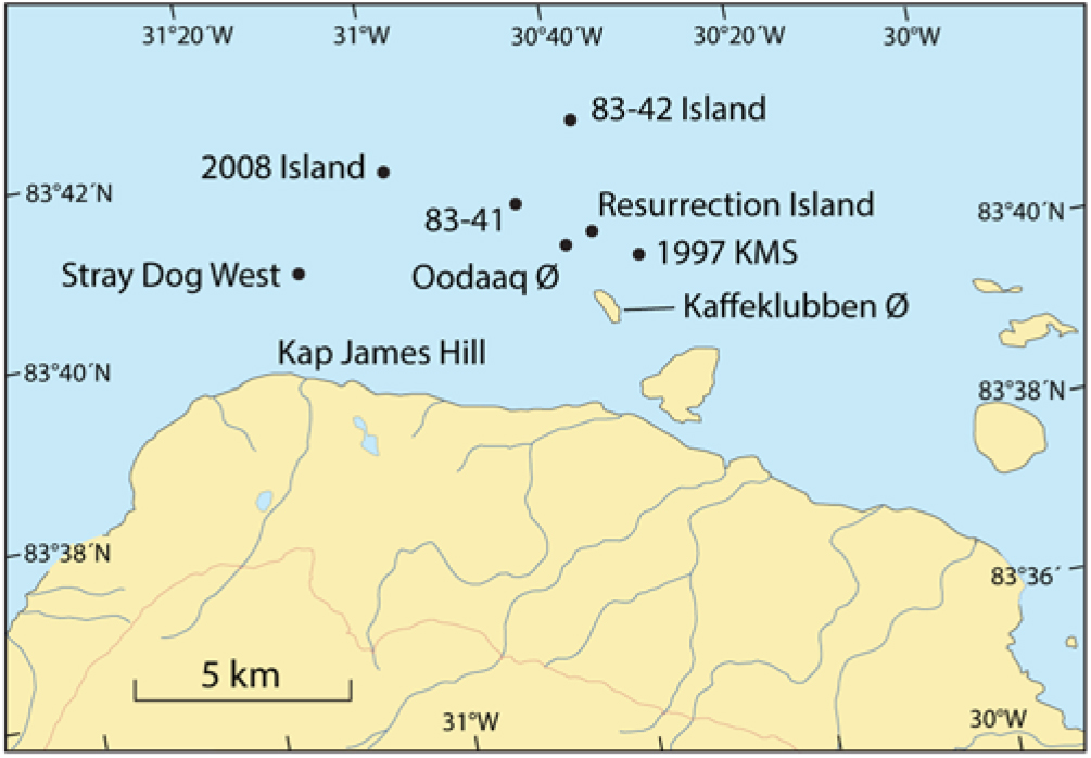
Fig. 4. Map of the Kaffeklubben Ø region showing the location of reported islets north of Greenland. Contour line: 100 m.
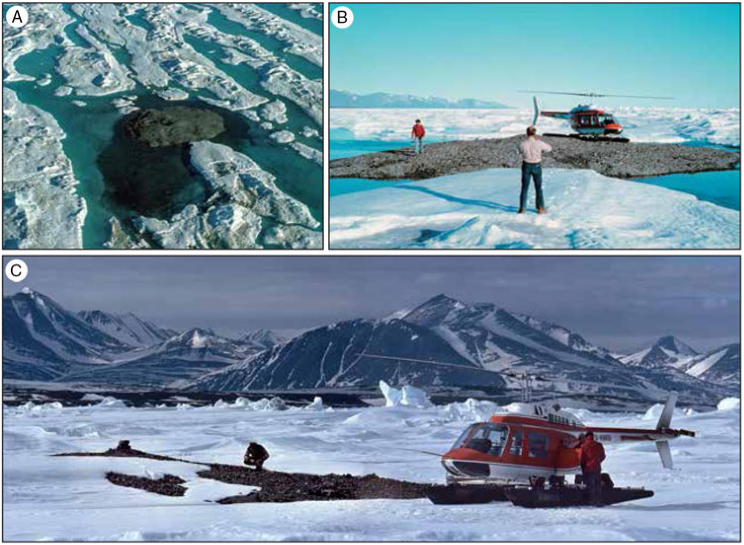
Fig. 5. Photographs of Oodaaq Ø. (A) The island seen from a helicopter and (B) from the ground. Both photographs are by Anders-Færch Jensen from the former Geodetic Institute on 29 July 1978. (C) Oodaaq Ø seen from the north on 30 June 1979. Photograph by Urs Stoller. The cairn built by members of the Sirius sledge patrol in March is seen to the left (east). Large parts of the island were snow-covered in late June. The mountains of northern Peary Land are seen in the background.
At first, Uffe Petersen suggested to name the new island Susan Ø, but later he proposed, together with Kruse Ekholm (head of the Greenland division at the Geodetic Institute) to name the island Oodaaq Ø in Danish and Oodaap Qeqertaa (literally, Oodaaq’s island) in Greenlandic. These names were authorised by the Greenland Place Name Committee at a meeting on 28 August 1980 (Petersen, Reference Petersen1986; Lisathe Møller, personal communication, 3 September 2018). The islet was named after the famous hunter Oodaaq (also spelled Uutaaq, Ûtâk, Ôdâq, Odark) who participated in four polar expeditions, including Peary’s last attempt to reach the North Pole in 1909.
On 30 March 1979, a sledge team from the military Sirius sledge patrol with Uffe S. Brink and Hasse Nielsen visited the island and built a small cairn (Thomas Hauerberg Hansen, personal communication, 17 July 2018).
On 30 June 1979, the geologists Svend Funder from the Geological Museum in Copenhagen and Christian Hjort from Lund University visited the islet as part of a new Geological Survey of Greenland expedition. They found a note inside the cairn built by the March 1979 Sirius team (Funder, Reference Funder1980). The island was easy to locate because the pilot Urs Stoller had also been there in 1978. But Dawes (Reference Dawes, Martens, Jensen, Meldgaard and Meltofte2003) and Johnson (Reference Johnson2011) questioned whether Funder and Hjort may have visited an islet other than Oodaaq Ø. Gardiner (2003, p. 101) also mentioned the possibility that the coordinates taken of Oodaaq Ø in 1978 could be wrong. However, Funder and Hjort (Reference Funder and Hjort1980) asserted that the islet visited in 1979 was indeed the same islet visited in 1978. They noted that the 1979 islet was in the same relative position to Kaffeklubben Ø and surrounding morphological features as the 1978 discovery. According to the pilot Urs Stoller, there is no doubt that it was the same island he visited in 1978 and 1979 (Urs Stoller, personal communication, 13 July 2018).
Oodaaq Ø measured c. 50 × 50 m and was scarcely 1 m high (Funder & Hjort, Reference Funder and Hjort1980). The island was composed of sorted silt, sand and gravel covered by a veneer of rounded pebbles, cobbles and boulders, mainly about 10 cm in diameter, but up to 30 cm, and it was interpreted as a beach ridge resting on sublittoral marine sediments, possibly the remnant of kames. Funder and Hjort dug a 30 cm deep hole; below 30 cm the ground was frozen (Funder, Reference Funder1980; Funder & Hjort, Reference Funder and Hjort1980).
The silt contained well-preserved in situ shells of the following marine invertebrates: Porella concinna (bryozoan), Margarites groenlandicus, Hiatella arctica and Lima hyperborea (molluscs), Serpulidae indet. (polychaete), Strongylocentrotus pallidus and S. droenbachiensis (sea urchins). Some of the species have thin shells that rarely are found as fossils (Bennike, Funder, & Hjort, Reference Bennike, Funder and Hjort1986). Funder and Hjort reported the same rock type on Oodaaq Ø as on Kaffeklubben Ø and mentioned that it was the dominating rock type on both islands.
In 1978, three species of bryophytes were found growing on Oodaaq Ø. Two of them could be identified as Desmatodon suberectus and Funaria arctica, whereas the third species could not be identified (Andersson, Funder, & Hjort, Reference Andersson, Funder and Hjort1980). Desmatodon suberectus is a synonym of Tortula leucostoma. Both species appear to be widespread in Greenland and grow as pioneer species on mineral soil. No bryophytes have been reported from the other islets, but the specimens from Oodaaq Ø were tiny, 1–2 cm tall and grew in crevices between stones. Such small plants may have been overlooked on other islets later visited in the region.
In 1980, Oodaaq Ø was observed from Kaffeklubben Ø by members of the Sirius sledge patrol. In the following years (1981, 1982, 1983 and 1984), the island was searched for by the patrol, but with no result (Thomas Hauerberg Hansen, personal communication, 17 July 2018).
Later expeditions
In 1995, Dennis Schmitt began to explore the area by flying to northern Greenland from Canada with Dr. Ruthmary Deuel. Schmitt wanted to study the nature of the sea ice (texture, size and quantity of pools of water and snow cover on the ice). Of particular importance to him was determining whether the sea ice was accessible from land. Flying at low elevations, Schmitt noted “rock features” north and east of Kaffeklubben Ø (Shea, Reference Shea2012).
In 1996, members of the American Top of the World (ATOW) Expedition flew to Bliss Bugt with a Twin Otter aircraft. The main objective of the expedition was to reach Oodaaq Ø on foot, as all previous expeditions to Oodaaq Ø had arrived by helicopter. During a reconnaissance flight, an island was spotted north of Kaffeklubben Ø. The expedition visited Kaffeklubben Ø and found a note in the cairn left by the Sirius sledge patrol in 1982. The note mentioned that Oodaaq Ø could not be located (Schmitt, Reference Schmitt1997). Some days later, late on 10 July, the expedition located a c. 60 cm long, c. 20 cm wide boulder sticking out of the water in the middle of a melt water pool (Fig. 5). Water was trapped over the island by surrounding small ice ridges. The 1996 team initially rejoiced, thinking that they had rediscovered Oodaaq Ø. The site was revisited three days later by Bob Palais and Dennis Schmitt. The ice ridges trapping the water around the boulder had melted. As the pool of water drained away, they watched an island emerge. That day, Palais and Schmitt agreed that it did not match the descriptions of Oodaaq Ø (Dennis Schmitt, personal communication, 5 November 2018). Also, the geographical coordinates did not quite match. Nevertheless, in April 1997, Jancik and Zerbst sent a report to the Polar Center in Copenhagen stating that the expedition had rediscovered Oodaaq Ø (Jancik & Zerbst, Reference Jancik and Zerbst1997) and Schmitt sent a report to the American Alpine Journal stating that the expedition had found Oodaaq Ø (Schmitt, Reference Schmitt1997). In May 1997, a Life magazine article on the 1996 expedition showed the image of the lone flat rock in the middle of the melt pool, claiming that Oodaaq Ø had been found again (Rowell, Reference Rowell1997). But the photographs taken by Palais and Schmitt on their second visit showed the shape of the entire island after the pool had drained. These images did not agree with photographs of Oodaaq Ø taken before its disappearance. Thus, despite the conflicting initial accounts, it later became clear that the 1996 team had found a new islet that was c. 15 m long, 10 m wide and 1 m high and covered by up to 50 cm large angular boulders (Fig. 6; Baker, Reference Baker2003; Schmitt, Reference Schmitt2004; Skafte, Reference Skafte2005a). The islet is known as the 1996 ATOW Island or the 1996 American Top of the World Island, but Schmitt renamed it retrospectively Resurrection Island to symbolise its miraculous appearance. The position was determined to 83°40’34.8”N, 30°38’14”W, to the north-east of Oodaaq Ø (Fig. 4). On the return to Kaffeklubben Ø, a flat land area (a gravel bar or islet) was located north of Kaffeklubben Ø but not further investigated (Baker, Reference Baker2003). Members of the 1996 expedition were Theresa (Terri) Baker, Steve Gardiner, John Jancik, Bob Palais, Galen Rowell, Jim Schaefer, Dennis Schmitt, Joe Sears, Peter Skafte and Ken Zerbst.

Fig. 6. Photographs of the 1996 ATOW Island. (A) On 10 July, a c. 60 cm long by c. 20 cm wide boulder was located; it was sticking out of the water in a melt water pool. (B) Most of the islet was submerged on 10 July. (C) Bob Palais on the islet on 13 July 1996. Note angular large boulders. (D) The 1996 ATOW Island seen from a Twin Otter aircraft in July 2001. Photographs by John Jancik, except C, by Dennis Schmitt.
Inspired by the photographs in the Life magazine, René Forsberg and Nynne Sole Dalå from the former Kort & Matrikelstyrelsen (KMS, National Survey and Cadastre) visited the area by helicopter in July 1997. René Forsberg reported a 50 × 50 m islet with a small cairn built of fist-sized stones. They felt this island was consistent with Oodaaq Ø discovered in 1978 but the islet was located at 83°40’15.1”N, 30°30’34.5”W, 1800 m east-south-east of the 1978 location (Baker, Reference Baker2003; Fig. 4). The existence of a cairn on this feature remains a mystery. One explanation could be that an unidentified person visited this islet but did not report it. Another, more remote possibility, is that this was Oodaaq Ø moved by sea ice with the cairn intact. This islet has become known as the 1997 KMS Island or the KMS Island.
In the summer of 1998, Dennis Schmitt led the 1998 Euro-American North Greenland Expedition. The primary objective was climbing mountains, but Schmitt made a flight over the Kaffeklubben Ø area and found at least two “rock features” north of the 1996 ATOW Island (Schmitt, Reference Schmitt2004). On that flight, Peter Skafte took the first aerial photographs of what was later to become known as the 83-42 Island (Dennis Schmitt, personal communication, 1 January 2019).
In 2000, The International Greenland Expedition with Lonnie Dupre and John Hoelscher visited the 1996 ATOW Island, according to Johnson (Reference Johnson2011).
In 2001, a new expedition was organised to northern Greenland: the Return to the Top of the World (RTOW) Expedition. After climbing mountains to the south, the team accompanied by Hauge Andersson, then at the former Danish Polar Center, did a reconnaissance flight over the Kaffeklubben Ø area. The following information was noted: (1) 1997 KMS Island was easily visible at the recorded coordinates. (2) The 1996 ATOW Island was likewise found at the recorded site and photography showed multiple large flat boulders. (3) The suspected gravel bar or island north of Kaffeklubben Ø located in 1996 was noted, but only inadequate GPS or photographic documentation was obtained. (4) No trace of Oodaaq Ø was found at the 1978 site. (5) The team spotted a potential new island at 83°41’06”N, 30°45’36”W – farther north than any of the other islets reported so far. This islet, named the 2001 RTOW Island, was photographed from the air and its coordinates determined from the aircraft. Members of the 2001 expedition were David Baker, Theresa (Terri) Baker, Steve Gardiner, John Jancik, Jim McCrain, Jim Schaefer, Joe Sears, Vernon Tejas and Ken Zerbst.
In 2003, Dennis Schmitt led the 2003 Euro-American Expedition to the region. On 6 July, six members of the expedition walked from Bliss Bugt to Kaffeklubben Ø and farther north. At 83°41’05”N, 30°45’33”W, they found a 7 m high ridge of sea ice that extended for more than 100 m in a generally east–west direction. The ice ridge appeared to be covering land beneath it. Some rock specimens were collected from a split in the covering of ice (Schmitt, Reference Schmitt2004). The ridge may have covered the 2001 RTOW Island that was seen from the air in 2001. Schmitt named the feature 83-41. It is uncertain whether 2001 RTOW and 83-41 are the same feature.
Continuing to the northeast, the expedition members found an island at 83°42’05”N, 30°39’W. This island now bears the names 83-42 Island, the 2003 Euro-American Island or the Schmitt Island. In 2003, the islet was 30 m long, 15 m wide and 4.5 m high. The island consisted of pebbles, cobbles and some boulders and it had lichens growing on the rocks – a sign that it has been there for a substantial time period. The team built a cairn on the islet but did not leave a message. They saw no other islands when looking north. Members from 2003 included Mara Boland, Marilyn Geninatti, Ans Hoefnagel, Rich Jali, Frank Landsberger, Andy Rash, Alan Schick, Dennis Schmitt, Peter Skafte and Patricia Thouvenin (Schmitt, Reference Schmitt2004; Skafte, Reference Skafte2005b).
On 12 July 2007, the Euro-American 2007 North Greenland Expedition, led by Dennis Schmitt, visited Stray Dog West Island (Kitaa Qeqertoq) at 83°40’37”N, 31°12’W (Fig. 7C &D, 8; Shea, Reference Shea2012). The islet, also known as Western Island, had been spotted on satellite images prior to the expedition. (The photograph in Fig. 7C was taken after the expedition; when viewed in large scale, the expedition’s tracks in the snow are visible). On this visit, exposed gravel covered c. 100 × 30 m, but part of the island was covered by ice and it was estimated that the island measured 100 × 60 m. Two photographs of the island taken by Jeff Shea are found in Richardson (Reference Richardson2007). Stray Dog West is the most westerly of the islets discovered in the region. The 2007 expedition members were Steve Kabala, Bob Mittleman, John H. Richardson, Dennis Schmitt, Jeff Shea and Holly Wenger.

Fig. 7. (A) The 2001 RTOW Island seen from a Twin Otter in July 2001. Photograph by John Jancik. In 2003, the island appeared as a 7 m high ridge of sea ice. (B) The 83-42 Island was visited on 6 July 2003. This islet is also characterised by large angular boulders. Photograph by Dennis Schmitt. (C) Stray Dog West Island seen from a Twin Otter aircraft on 16 July 2007. The island is partly covered by ice and snow. Photograph by Jeff Shea. (D) Stray Dog West Island on 12 July 2007, with rounded pebbles and small boulders. Photograph by Jeff Shea.
On 26 July 2008, a helicopter-assisted expedition led by Ken Zerbst visited an islet at 83°41’20.7”N, 31°5’28”W. The islet appeared as a 100 m long, thin narrow piece of land. Some angular boulders were used to erect a small cairn, in which was deposited American, German and Swiss flags as well as a note with the position of the islet (Wikipedia, 2018; Ken Zerbst, personal communication, 16 October 2018). A photograph of the islet was published by Glagow (Reference Glagow2008). The ridge was a few metres high and consisted of unsorted sediment with mud, gravel and angular boulders (Fig. 9). Members of the 2008 expedition were Brian Beatty, Friederike Castenow, Heinz and Lindy Fischer, Jörg Teiwes, Ken Zerbst and Peter von Sassen.

Fig. 8. Satellite image from the summer 2005 showing Stray Dog West Island (arrow) surrounded by fast sea ice. The islet measures c. 100 × 30 m. It appears that there are several more islets on the image. Before the expedition landed at Bliss Bugt, the Twin Otter aircraft circled around the sea ice to check several of those other potential islets. Only Stray Dog West was deemed to be a solid islet, and hence, it was the only one on the satellite image that was visited. Source: NASA.

Fig. 9. (A) Overview of the 2008 Island. (B) Putting down a note in the cairn on the 2008 island. (C) The 2008 team on the islet. (D) large angular boulder, probably a granite. Photographs taken on 26 July 2008 by Peter von Sassen (A, D) and John Jancik (B, C).
Finally, on 1 August 2008, during helicopter-based field work, a Danish team visited some of the areas where islands had formerly been reported (Riise-Jensen & Vestergaard Olesen, Reference Riise-Jensen and Vestergaard Olesen2008). During a flight over the old position for Oodaaq Ø, nothing was observed that indicated the presence of islands, neither unusual colours nor bumps in the snow or ice cover.
However, significant amounts of sediment were found in and on the sea ice about 200 m north of the position of the 1997 KMS observation, at 83°40.252’N, 30°30.58’W. The material was fine sand or clay without stones. It was not clear whether it was an island or just material embedded in the ice. At the actual coordinate for the 1997 KMS observation, nothing was found indicating the presence of an island.
At almost the same position (about 20 m distant) as the 83-42 Island, at 83°42.12’N, 30°44.22’W, a dome-shaped structure was observed (Fig. 10). It measured about 30 m in diameter and was 2 –3 m high. The structure was covered by snow and ice; it was not possible with the tools available to reach any underlying sediments. There were, however, some areas with melting along the edges of the structure that revealed the presence of sediment in the water. The visit took place at the same day that a total solar eclipse occurred in the region, and hence the structure was called Eklipse Ø. Due to variability in GPS coordinate readings from different systems, it is possible that Eklipse Ø and 83-42 are the same island in the same place, or that it is the same island but moved 20 m away in the five-year interim between the 2003 Euro-American Expedition and the 2008 Riise-Jensen and Vestergaard Olesen field study.

Fig. 10. (A, B) A dome-shaped sea-ice structure was found 20 m from the position of the 83-42 Island; part of the structure is seen in the left part of B. The structure was called Eklipse Ø. (C) Sea ice covered by patches of sediment observed in an area 200 m north of the 1997 KMS Island. (D) Drifting sea ice partly covered by muddy sediment at 83°43.10’N, 30°28.83’W. The sea ice drifted to the west at a speed of c. 0.2 km/hour. The photographs were taken on 1 August 2008. Photographs: Carsten Riise-Jensen (A); Arne Vestergaard Olesen (B–D).
At the position 83°43.10’N, 30°28.83’W (about 4 km distant from Eklipse Ø) there was a lot of sediment material. However, it became clear that instead of an island, it was just material embedded in the sea ice. The area moved westward at a speed of about 0.2 km/h. The appearance of this area was very similar to the area 200 m north of the 1997 observation but it covered a significantly larger area. The August 2008 team consisted of Carsten Riise-Jensen and Arne Vestergaard Olesen.
Discussion
It appears that the islets north of Greenland come and go, but it is difficult to determine which islets have been observed where and when. The first islet, Oodaaq Ø, was discovered and visited in 1978. It was revisited twice in 1979 and observed in 1980 – but later attempts to find it have failed. In 1995, new interests in the islets arose and during the period from 1996 to 2008 the region was visited repeatedly. Unfortunately, extremely little data have been published from these visits; only vague information about the size of the different islets is available; the same goes for the materials found on the islets. Mosses were found on Oodaaq Ø and lichens on the 2003 Euro-American Island. No other notes on vegetation are found, but we do not know if the visitors searched for plant life. Also, we do not know if visitors have searched for fossil shells on the islets visited.
It appears that no data are available on water depths in the area. It would be important to acquire bathymetric data to evaluate if floes of sea ice can potentially push sediment up from the sea floor to create small islands. If leads in the sea ice form in coming years, water depth can easily be measured; if not, an ice auger may be used to drill holes in the ice.
It seems likely that glacial landforms created during the last ice age are found on the sea floor in the region, and the area may be characterised by an undulating, irregular sea floor bathymetry, where ice floes may bulldoze material up above sea level to form islets. Push mounds formed by bulldozing of sediment by floes of sea ice have been described from the inner shelf of the south-eastern Canadian Beaufort Sea by Héquette et al. (Reference Hequette, Desrosiers and Barnes1995). The largest mounds were formed by grounded ridges of sea ice at water depths over 12 m. Along the northern coast of Alaska, sea ice was found to be effective in reshaping the sea floor and the bulldozing of sea ice resulted in coast-parallel sediment transport (Reimnitz & Barnes, Reference Reimnitz, Barnes and Kraus1987). Pressure ridges up to 55 m thick have been reported in north-eastern Greenland. Such large ridges may plow the sea bed in relatively deep water (Hansen, Adamsen, Olsen, & Amstrup, Reference Hansen, Adamsen, Olsen and Amstrup2005).
Even though land-fast ice characterises the sea in the Kaffeklubben Ø area, we envisage that some movement of the sea ice may occur in late summer or early autumn, when areas of open water form. Similarly, sediment forming the islets may be pushed down onto the seabed. This could explain why the islets appear and disappear. Alternatively, the so-called islets are just accumulations of gravel on sea ice.
Conclusion
In 1978, an islet was discovered off the north coast of northernmost Greenland. It was named Oodaaq Ø after the famous hunter Oodaaq who participated in four polar expeditions. The islet was last observed in 1980; in the four following years, it was searched for by members of the Sirius sledge patrol but not found. During the period from 1996 to 2008, at least six other islets were located in the same region as Oodaaq Ø. Only little information has been published on what was observed on the islets, and most of the islets have several different names. Here, we have compiled the available information. Most of them, if not all of them, have disappeared and it seems that the islets are short-lived features.
“When I began to explore these islands, I sensed they were ephemeral. But I also realized that they were poetic constructs, the Ultima Thules of the western romantic and scientific imagination. I chose to embrace them as such, not making more of their substance than was there. That is why I called them “Les Chiens Égarés”, “Kimmiapahluit”, “The Stray Dogs”, and it is poetically fitting that the world’s most geographically transcendent islands are also the most lacking in substance. In the end, I think they are more important as an idea than as a physical reality.” – Dennis Schmitt, 2007
Author ORCIDs
Ole Bennike 0000-0002-5486-9946
Acknowledgements
We are grateful to Anders Færch-Jensen (The Danish Agency for Data Supply and Efficiency, Copenhagen, Denmark), Arne Vestergaard Olesen (Westagard Geo Solutions, Hundested, Denmark), Carsten Riise-Jensen (Danish Geodata Agency, Nørresundby, Denmark), Dennis Schmitt (Berkeley, California, USA), John Jancik (Colorado, USA), Ken Zerbst (Colorado, USA), Peter von Sassen (Germany) and Urs Stoller (Frutigen, Switzerland), who provided information and most graciously gave us permission to use some of their photographs. Peter Dawes, (Geological Survey of Denmark and Greenland, Copenhagen, Denmark) generously lent us his material on the transient islets. Thomas Hauerberg Hansen (Danish Joint Arctic Command, Air Transport Wing Aalborg, Denmark) kindly provided information on observations by the Sirius sledge petrol. Emerald Nash (The Explorers Club, New York, USA), Lisathe Møller (The Greenland Language Secretariat, Nuuk, Greenland), Peter Skafte (Santa Barbara, California), René Forsberg and Simon Ekholm (both at DTU Space, Technical University of Denmark, Kongens Lyngby, Denmark), Uffe Petersen (Hillerød, Denmark) and Willy Weng (Geological Survey of Denmark and Greenland, Copenhagen, Denmark) also provided information. Christian Marcussen and Stuart Watt (Geological Survey of Denmark and Greenland, Copenhagen, Denmark) kindly commented on the manuscript. We also thank an anonymous journal reviewer for constructive comments. The paper is published with the permission of the Geological Survey of Denmark and Greenland.