


Introduction
The challenges faced by Arctic states in the context of an aggravated conflict of geopolitical and economic interests in the region result in the need to search for new areas of cooperation. In this context, the most promising ones appear to be opportunities for scientific cooperation. It implies the involvement of international scientific alliances and collaborations in order to address common global issues and improve global relations with financial and institutional government support (Krynzhina, Reference Krynzhina2018; Sellheim et al., Reference Sellheim, Zaika and Kelman2019; Wilson Rowe, Reference Wilson Rowe2018). The principles of scientific cooperation emerged and developed during the study of the Arctic. The interaction between individual scientists was replaced by the joint scientific endeavours involving laboratories, scientific academies, research centres and the foundations of different countries. One of the first examples of international scientific cooperation in the Arctic can be found through joint expeditionary research. The historical experience of organising the activities of the International Meteorological Committee (founded in 1873) and conducting the First International Polar Year 1882–1883 and the 1898–1901 Swedish–Russian Arc-of-Meridian expedition indicates that the implementation of inter-academic scientific cooperation practices promoted the interaction of the international scientific communities within a joint scientific project without the need for integration into a single team. In Russian historiography, the 1898–1901 Swedish–Russian Arc-of-Meridian expedition to the Spitsbergen archipelago appears as the Russian–Swedish expedition on degree measurement on the Spitsbergen Islands.
In the modern era of globalisation, the practice of scientific cooperation is intensified and brings joint expeditionary research in the Arctic to a new level. An example of a recent large-scale project in the Arctic is the 2019–2020 year-round international polar expedition MOSAiC (Multidisciplinary drifting Observatory for the Study of Arctic Climate) with a budget of 140 million Euros. Eighty different organisations from 20 countries took part in its preparation and implementation (MOSAiC, 2021). The international team of scientists investigated the effects of climate change in the Arctic and the current conditions of ice formation.
The experience of organising and conducting the 1898–1901 Swedish–Russian Arc-of-Meridian expedition is important for understanding the historically developed mechanisms of interaction between state and academic structures involved in modern international scientific cooperation in the Arctic. The military and naval government agencies of Sweden and Russia were interested in measuring the meridian arc near the Geographic North Pole. The results of the measurement enabled scientists to identify the shape of the Earth as a geoid and thereby confirm the Newton–Huygens hypothesis – that the shape of our planet is a sphere flattened at the poles, and was of practical importance for the purposes of navigation and sailing.
Discussion
A review of the development of degree measurement methodology reveals an international interest in solving problems associated with determining the shape of the Earth. In the 1730s, an improvement in geodesy instrumentation allowed French and Swedish scientists to measure baselines and angles in Peru and Lapland. Decades later, other European researchers carried out degree measurements in Italy, at the Cape of Good Hope and in Pennsylvania, USA. The triangulation method for this cartographic work continued to develop throughout the 19th century and was successfully used by researchers in Germany, England, Sweden, Norway and Russia (Torge, Reference Torge2015).
The most ambitious international triangulation project of the first half of the 19th century was known as the Struve Geodetic Arc. This was a chain of 258 triangles with a common side, which stretched 2820 km from north to south along the 25-degree meridian east longitude from the banks of the Danube to the Arctic Ocean. Starting in 1816, measurements had been taken for almost 40 years. The first part of the project was carried out under the auspices of the Imperial Academy of Sciences with finances donated personally by Emperors Alexander I and Nicholas I. This project involved researchers from the Dorpat and Pulkovo observatories under the leadership of Vasily Yakovlevich (Friedrich Georg Wilhelm) Struve (founder of the Russian Geographical Society) and military surveyor Colonel (later Lieutenant General) Karl Ivanovich (Karl Friedrich) Tenner. By the 1840s, the meridian arc was measured for approximately 1300 km (Puziene, Reference Puziene2019).
Further work was conducted on the territory of Sweden and Norway in 1845–1847, 1850. Under the direction of the Imperial Saint Petersburg Academy of Sciences, V.Ya. Struve arrived in Stockholm in 1844 to secure the patronage of the Swedish government for conducting joint measurements. He was successful in doing so and a committee was created in Sweden to support this work (Lindberg, Reference Lindberg2011). This committee included N.H. Selander, director of the Royal Observatory of Stockholm and F.Ya. Wrede, the Swedish king’s aide-de-camp, as well as Christopher Hansteen, director of the astronomical and magnetic observatory in Christiania (now Oslo: in our study, we adhere to the position of researchers who, in a historical context, employ toponyms that were in use during the period under review, indicating modern ones in brackets) (Roberts, Reference Roberts1948). In 1844, Swedish and Norwegian King Oscar I approved the project for measuring the meridian arc throughout Scandinavia. Results identified through the project included a gradual rise of the Scandinavian Peninsula above sea level and a variance between the levels of the Arctic Ocean and the Baltic Sea. The Russian government was most interested in the early acquisition of new geodetic data as it was required by the Military Topographic Depot to compile accurate maps of European Russia. V.Ya. Struve, N.H. Selander and C. Hansteen compiled the results of the long-term project during an 1853 Stockholm meeting. The results were published in Russian and Swedish academic journals and were well received by the international scientific community (Shrader, 2003). In 2005, the surviving 34 points of the Struve Arc attained UNESCO World Heritage Site status.
After Scandinavian and Russian scientists had completed the calculation of the meridian arc in the territories of their respective countries, the necessity for expanding degree measurements to higher latitudes of the circumpolar regions in order to clarify the magnitude of the Earth’s compression at the poles became evident. It was assumed that such research should be carried out on the Spitsbergen archipelago because its islands stretched along the meridian arc by more than four and a quarter degrees. It also had a sufficient number of high peaks for the installation of signs for astronomical and geodetic observations (Anisimov & Onopriyenko, 1985).
Degree measurement in the Spitsbergen archipelago had first been conducted by English physicist and mathematician Sir Edward Sabine in 1826 (Stone, Reference Stone1984). While taking part in Parry’s 1819–1820 Northwest Passage, Sabine took magnetic measurements in an attempt to locate the North Magnetic Pole. Between 1821 and 1823, he carried out geodetic measurements. By measuring the length of a second pendulum in different latitudes, he calculated the “oblateness” of the Earth – i.e. the degree to which the “figure of the Earth” departs from perfect sphericity. He travelled along the Sierra Leone coast and from the eastern coast of North America to Spitsbergen and Greenland (Wrakberg, 2002; Vasiliev, Reference Vasiliev1915).
In the middle of the 19th century, inter-state relations between Russia and Sweden became complicated due to Sweeden’s neutral position during the Crimean War and the 1855 Treaty which favoured Great Britain, France and the United Kingdoms of Sweden and Norway. Nevertheless, scientists from both countries continued to study the geography of the Earth’s high latitudes. In 1861 and 1864, the Royal Academy of Sciences in Stockholm sent reconnaissance expeditions to the Spitsbergen archipelago in order to determine the feasibility of taking degree measurements there. Members of these Swedish expeditions included astronomer Nils Christoffer Duner and geologist and geographer Nils Adolf Erik Nordenskiöld. In 1866, the two men presented their proposed degree measurement project on Spitsbergen with a map of the triangulation network to the Royal Academy of Sciences in Stockholm (Wrakberg, 2019). The Royal Academy supported the project in theory but did not have sufficient funds to organise an initiative on this scale. However, Sweden and Russia did not cooperate jointly on this project at this stage. In the 1860s–1870s, the geopolitical situation between the two countries was aggravated as a result of competing territorial claims on Spitsbergen. Only in the late 1880s after the signing of conventions between Russia and Sweden conferring the legal status of terra nullius on Spitsbergen did negotiations relating to scientific cooperation continue (Shrader, 2003). A consensus regarding the need for international scientific cooperation in the Arctic emerged during this decade. In 1875, at the 48th Meeting of German Naturalists in Graz, Karl Weyprecht had reported on the fundamental principles of scientific research in the Arctic. These principles later provided the underpinning for the First International Polar Year 1882–1883 that involved scientists from 12 countries including Russia. During this period, scientists conducted geophysical, meteorological, and biological observations at 14 polar stations.
Previously, the international activities of the Imperial St Petersburg Academy of Sciences focussed on the formation of an institute providing honorary membership for foreign scientists in the Academy. At this time, the interaction between scientists of different countries was limited to personal contacts and the sharing of scientific literature. This began to change at the turn of the 20th century as Russian scientists began to actively participate in international scientific organisations and projects. Members of the Academy of Sciences displayed their competence through their work with the International Seismological Association, the International Union for the Study of Central and East Asia, the International Magnetic Committee and the International Aeronautical Commission as well as working at international research stations (Shabalina, Reference Shabalina2014a). At the invitation of the Royal Society of London, the Imperial St Petersburg Academy of Sciences took part in the compilation of a reference book of natural science literature entitled “International Catalogue of Scientific Literature”, which was published between 1902 and 1921 (Tunkina, Reference Tunkina2018).
At the same time, astronomer O. A. Backlund supported the Swedish proposal made to Russian scientists to jointly participate in a new project centred on the degree measurements of Spitsbergen. The revised and approved project was presented by astrophysicist Dr. P.G. Rosen to the Royal Academy of Sciences in 1891 and used the triangulation network map in the archipelago, compiled during the Swedish reconnaissance expeditions, as evidence. In 1897, Swedish King Oscar II received Backlund onboard the royal yacht Drott where Backlund announced joint plans for scientists from both countries. The astronomer also presented a report to the President of the Imperial St Petersburg Academy of Sciences. This report was read out at a meeting of the influential Physics and Mathematics Department of the Academy of Sciences on November 19, 1897 and received the department‘s endorsement (Wrakberg, 2002).
The main objective of this article is to present a historical reconstruction of the interactions between scientific communities and state institutions during the preparation and implementation of the 1898–1901 Swedish–Russian Arc-of-Meridian expedition to the Spitsbergen archipelago. This international scientific project is reviewed in terms of the scientific cooperation practices that were developed during the expedition. The research for this paper is based on the archival collections of the Russian Academy of Sciences. These sources became the objects of analysis within the framework of the humanitarian and systematic approaches using general scientific methods based on scientific knowledge, archival heuristics, source study and comparative method.
Archival sources of the case study
During the preparation of this paper, the authors applied archival heuristics practice and studied the accessible data sources of the St Petersburg branch of the Archive of the Russian Academy of Sciences and the Museum-Archive of History of Studying and Development of the European North, Barents Center of Humanities, Federal Research Centre “Kola Science Centre of the Russian Academy of Sciences” (BCH KSC RAS), located in Apatity, Murmansk region. Documents on the history of the 1898–1901 Swedish–Russian Arc-of-Meridian expedition are presented in other large archives as well such as in the archives of the Russian foreign policy and military departments. However, most of these documents are duplicates (Derzhavin, Reference Derzhavin and Bouzney2002).
The most informative set of documents relating to scientific cooperation and the joint efforts of Russia and Sweden and the Spitsbergen archipelago project is stored in the collections of the St Petersburg-based branch of the Archive of the Russian Academy of Sciences. The authors of this article studied the documents that were mainly related to the organisation of expeditionary work in Spitsbergen and the coordination of efforts by the Russian and Swedish scientists as well as documents detailing the interaction between the state institutions of the participating countries. These include papers from Collection No. 13 “Commission of the Academy of Sciences for Degree Measurement on the Spitsbergen Islands” (1898–1929) and the reporting documentation of the Academy of Sciences on the work of this Commission. Russian scholar F.N. Chernyshev had been jointly appointed with O.A. Backlund as the head of expeditionary work on Spitsbergen. From 1899 to 1901, he had reported to the Conference of the Academy of Sciences on the results of the joint work of Russian scientists and Swedish colleagues. These reports include attachments with clarifying information about the status of the research. For example, an Appendix to the 1900 report includes a speech by Chernyshev and an Appendix to the 1901 report entitled, “The Work of the Expedition on Degree Measurements on Spitsbergen in 1901” which outlined the results of the final stages of the expedition. A careful study of the materials of the Commission enabled the authors to reconstruct the course of the joint expeditionary research carried out by the Russian and Sweden scientific communities in Spitsbergen, as well as identify the scientific communication practices in the Arctic.
Formed by the Academy of Sciences in 1898, the Commission for Degree Measurements on Spitsbergen existed until 1917. Data analysis for the expedition continued for more than a decade. The Commission‘s activities are reflected in its minutes, which cover the period from March 16, 1898 to April 21, 1912. The minutes contain information important for understanding the features of scientific interaction during the period under review, the processes of coordinating the organisational aspects of scientific research and the development of a unified measurement methodology with Swedish colleagues. The collection of the Commission of the Academy of Sciences contains copies of documents prepared by the Swedes and sent to the Imperial St. Petersburg Academy of Sciences for review. These include the separate minutes of meetings attended by members of the Royal Swedish Academy of Sciences in 1900 as well as a report on the work of the 1902 Swedish Expedition on Degree Measurement.
A particularly valuable source of information for studying the aspects of international scientific cooperation is the correspondence of Russian expedition head Chernyshev with Swedish scientists. Collection No. 13 houses letters from V. Carlheim Gyllensköld, Secretary of the Swedish Commission in Swedish. Also included are letters from De Geer in German with brief considerations on the work of the expedition as well as telegrams from expedition members sent to Chernyshev from Stockholm, Pulkovo and Arkhangelsk. In addition, Backlund’s correspondence with expedition members from Russia and Sweden has been preserved. Addressees include A.R. Bonsdorff, Director of the Uppsala Meteorological Observatory, astronomer H.H. Hildebrandsson of Uppsala University, N. Ch. Dunér, E. Jaderin, P. G. Rosen, V. Carlheim Gyllensköld and O. Savander. The extensive correspondence testifies to its significance within the wider international scientific community of measurements. All correspondence with colleagues from other countries was in Swedish.
The Swedish–Russian Expedition of 1898–1901 was regulated at the national level. Therefore, Collection No. 13 also contains diplomatic correspondence from King Gustav of Sweden, the Secretary of the Swedish Commission to the Grand Duke Konstantin Konstantinovich, the President of the Imperial St Petersburg Academy of Sciences regarding the acquisition of scientific equipment and the organisation of the work. There is also correspondence about financial issues between the President of the Imperial St Petersburg Academy of Sciences, the Grand Duke Konstantin Konstantinovich, Finance Minister Witte and Foreign Affairs Minister Muravyov.
Cartographic materials from Collection No. 13 focus on plans for the triangulation network and the results of the expedition’s geodetic work. This includes both printed (typographic) and handwritten maps made by members of the expedition. Subsequently, some maps were included in the publications of expedition members based on research results (Fig. 1). Collection No. 13 also includes visual archival sources from the expedition including photographic negatives and positives depicting the equipment used, the ships, various campsites, expedition participants as well as travel sketches by Chernyshev, vegetation drawings by an unknown artist and Backlund’s sketches of soil sections. Contemporaneous Russian and German newspaper articles about the expedition’s progress and public response are located here also.

Fig. 1. Map of degree network system on Spitsbergen in 1902. Unknown author (Vasiliev, Reference Vasiliev1915).
The Museum Archive of the History of Studying and Development of the European North is the repository for the personal collection of N.I. Tulsky who was the senior navigator, second mate (1899–1907) and captain (1921–1922) of the Yermak (Fig. 2). The collection is comprised of personal documents and photographic materials that are important sources on the history of the 1901 Degree Measurements Expedition in Spitsbergen. These documents were deposited for storage in the Museum by Tulsky‘s family.
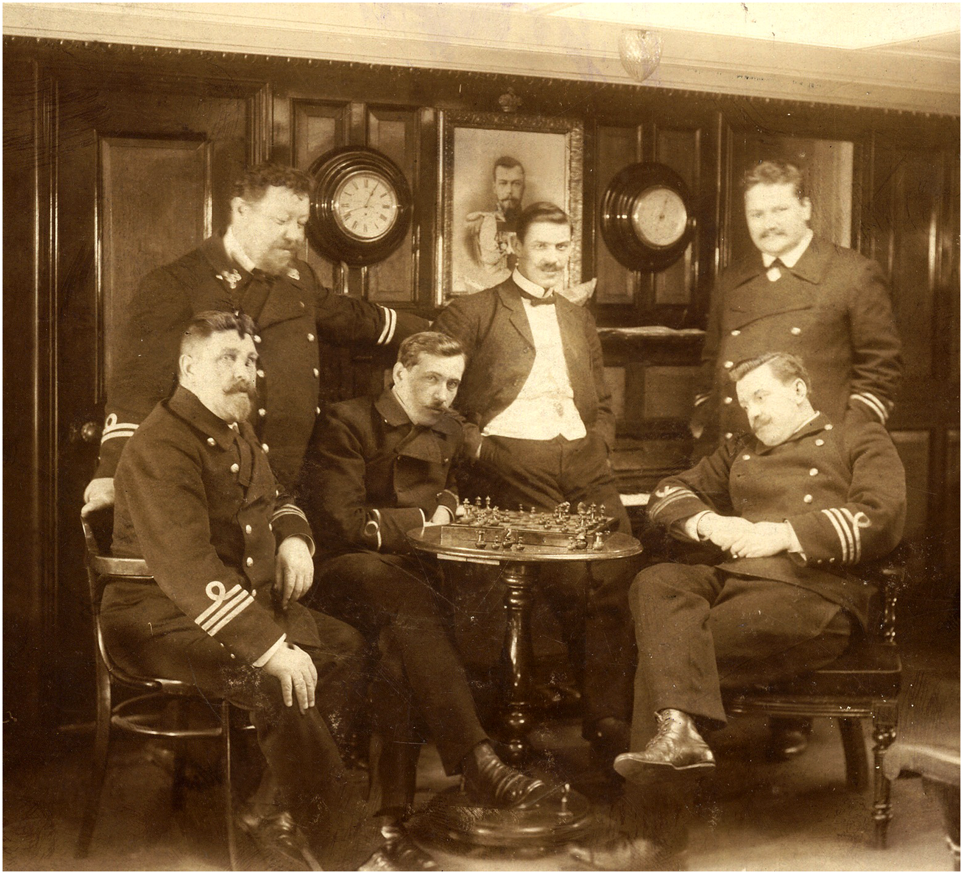
Fig. 2. In the wardroom of Yermak. N.I. Tulsky sits in the first row on the far right (Reference Tulsky1901). Unknown photographer. Source: The Museum-Archive of the BCH KSC RAS, c2, i1, f423.
Documents on the history of the Swedish–Russian Arc-of-Meridian Expedition to the Spitsbergen archipelago are also preserved in the Archives of the Royal Swedish Academy. These include “Documents of the Swedish Academy for 1899–1900” with materials containing diverse information about the expedition including diplomatic correspondence between representatives of the participating countries. In addition, there are the personal collections of Swedish scientists who took part in measuring the meridian arc at Spitsbergen such as the De Geer collection presented at Stockholm University (Meer, Reference Meer2004). During this study, the authors had access to only a few copies of documents by Swedish authors related to the research topic. These documents are stored in the St. Petersburg branch of the Archive of the Russian Academy of Sciences. It is likely that the Archives of the Royal Swedish Academy of Sciences contain documents of interest in this field as part of further research with broader objectives. Our study is intended to present the information potential on the chosen topic of two Russian academic archives, described earlier.
The study of the relevant archival and published sources revealed significant organisational and coordination efforts required at various levels by Russian and Swedish participants to ensure the preparation and operation of the Arc-of-Meridian Expedition on the Spitsbergen archipelago. The research that was conducted provided the authors with insight into the various aspects of the largest international scientific event of the late 19th – early 20th century in terms of the history of scientific cooperation practice.
Interaction between academic communities and state institutions
Historically, the advancement of national interests on the global stage took place through the formation of various strategic levers of influence. Gradually, scientific research became an important factor in this process. Joint research of individual scientists from different countries resulted in the establishment of scientific international alliances. The activities carried out by these alliances were aimed at solving common and important scientific problems and were supported by representatives of national institutions and foreign affairs‘ representatives. A review of the preparatory and main stages of the largest international scientific project of the late 19th – early 20th century offers insight into the development of inter-academic scientific cooperation practice.
1898
In 1898, after the acceptance of the proposal for joint degree measurements on the Spitsbergen archipelago, the Academy of Sciences created a commission lead by the Grand Duke Konstantin Konstantinovich to develop plans relating to expeditionary work. Members included Russian scholars O.A. Backlund, A.P. Karpinsky, M.A. Rykachev, B. B. Golitsyn and F.N. Chernyshev. Other commission participants were infantry generals – O.E. Stubendorf, chief of the Military Topographic Department of the General Staff, A. R. Bonsdorff, corresponding member of the Academy of Sciences and K.I. Mikhailov, honorary member of the Academy of Sciences General for the Admiralty. Members of the Royal Academy of Sciences and a national commission under the auspices of Crown Prince Gustav engaged in discussions with A.E. Nordenskiöld, Magnus Gustaf (Gösta) Mittag-Leffler and professor Edward Jaderin of the Russian Commission (Beznosov, Reference Beznosov2000; Gnucheva & Komarov, 1940).
On March 16, 1898, Russian academician F.N. Chernyshev took part in a session of the Swedish Spitsbergen Commission together with members of the Royal Academy of Sciences Nordenskiöld, Jaderin and Mittag-Leffler. The topic of discussion was organising an expedition on degree measurements in Spitsbergen. In June, Chernyshev visited Academy of Sciences museums in Stockholm and Christiania and studied the geological collections assembled by Nordenskiöld, De Geer and Nathorst in Spitsbergen. This included an examination of samples gathered by Nansen in Franz Josef Land (Anisimov & Onopriyenko, 1985). The same year, the Royal Academy of Sciences sent a preliminary reconnaissance party to Spitsbergen under the guidance of Jaderin (Palme, Reference Palme1923). His tasks included collecting data for the final installation of trigonometric points, choosing the most favourable places for measuring the baseline along the Stor Fjord coast, and, in northern Spitsbergen, placing geodetic signs in this part of the archipelago. This expedition also involved Russian F.A. Schultz, who was a Lieutenant Colonel of the Corps of Military Topographers. From May to October 1898, the expedition carried out the planned preparatory work for the subsequent degree measurements project and installed 10 metal and 5 stone pyramid signs. In addition, a Russian member of the expedition conducted daily meteorological observations (Palme, Reference Palme1923).
After Jaderin’s return from the reconnaissance expedition, members of the Russian commission, including Backlund, Bredikhin, Chernyshev and Golitsyn, met in Stockholm to discuss plans for international scientific expeditionary work. They were joined by Nordenskiöld, Dunér, Jaderin and De Geer. Members of the Russian delegation were honoured with an audience with the Crown Prince and Princess, thus emphasising the importance of this scientific project for Sweden (Shrader, 2003). During these sessions, representatives of the Academies of Science from both countries discussed various organisational issues. In particular, they finalised the expedition participants, approved the timeframe and the number of expedition ships and distributed the work between Russian and Swedish surveyors. While they reached a consensus about the number of specialists and workers in each geodetic party, agreeing on the scientific tasks of the expedition proved more challenging. The Swedes insisted on carrying out geodetic works during only part of the year. Russian scientists proposed collecting data year-round as they realised the importance of financial and human costs of organising and conducting a high-latitude expedition. As a result, it was decided to conduct all-season meteorological and physical observations as well as geodetic work. It was proposed that Russian and Swedish stations would be separated by 20–40 km (Commission of the Academy of Sciences for Degree Measurement on the Spitsbergen Islands, 1899–1915).
The expeditionary activities were funded on a parity basis from the budgets of both countries. Correspondence between the Grand Duke Konstantin Konstantinovich (who was President of the Imperial St Petersburg Academy of Sciences and the Chairman of the Commission on Degree Measurement), Finance Minister Witte and Foreign Affairs Minister, Count Muravyov, reveal that the monies allocated to this project by the Russian State Treasury had been done so on the orders of the Russian Emperor (Romanov, Reference Romanov1903; Witte, 1900). However, the planned expenses of 50,000 rubles per year for 1899 and 1900 were not sufficient to cover expenses in the first year of the expedition. At the end of January, 1900, Witte informed the Chairman of the Commission that “60,000 rubles were granted at the request of the Board of the Imperial Academy of Sciences” related to “additional expenses for the expedition for the execution of degree measurements on the islands of Spitsbergen“ (Witte, p. 271). Therefore, the Russian Treasury paid 160,000 rubles in extra costs for the expeditionary work. Actual Swedish expenses also exceeded the initial projected costs and amounted to more than 250,000 kronor (Romanov, Reference Romanov1903).
Unprecedented and thorough preparation for the unique expedition was carried out by both participating countries. The Russian consulate in Northern Norway provided assistance in organising the coal supply for future over-wintering; scientific instruments were purchased in Germany; equipment for over-wintering was sent by the Arkhangelsk governor and sled dogs were brought from Siberia (Shrader, 2003). The construction of houses for over-winterers was carried out by the Sandvik Ship Dock and Mechanical Plant in Helsinki. The houses were sent to Spitsbergen along with other cargo and coal on the Swedish ship Betty. Thanks to the assistance of Tyrtov, head of the Marine Ministry and Khilkov, Minister of Railways, the expedition was provided with the military steamer the Bakan (Fig. 3), and the icebreaker Ledokol II, commanded by Ergomyshev and Yakimovich, respectively. The Swedes had two ships between 1899 and 1901 – the military Svensksund and the cargo ship Rurik. Between 1901 and 1902, the steam frigate Antarctica, specially adapted for sailing in polar conditions, was also used. In 1901, the passage of ships through the Arctic ice was provided by the world’s first Russian Arctic-class icebreaker Yermak.

Fig. 3. The Russian command fleet personnel and researchers of the Swedish–Russian Arc-of-Meridian Expedition to Spitsbergen onboard Bakan. 1899. Unknown photographer. Source: The Archive of the Russian Academy of Sciences. St. Petersburg branch, c13, i1, f10, l2.
Preparatory work in winter-spring 1899
In February 1899, Russian project participants practiced and revised measuring baselines in the Pulkovo according to the Swedish method. The Pulkovo version of the Jaderin wire method that incorporated modifications by Wittram was used for measurements on Spitsbergen (Kaptüg et al., Reference Krawczyk1999). At Jaderin‘s invitation, in May 1899, the Russians arrived in Stockholm 2 weeks before the start of the expedition to practise measuring baselines and observe the swing of pendulums when determining the tension of gravity.
The Russian delegation was comprised of scientists, who were both astronomers and surveyors: A.S. Vasiliev, V.V. Akhmatov, A.P. Gansky, I.I. Sikora, A.D. Pedashenko and D.D. Sergievsky; physicists E.V. Stelling and A.R. Beyer and naturalists A.A. Byalynitsky-Birulya and student O.О. Backlund. An experienced polar traveller, zoologist A.A. Bunge and experienced mechanic E.K. Hahn were additional members (Vasiliev, Reference Vasiliev1915). The composition of the group was international. The head of the Swedish delegation was E. Jaderin and the Russian group was led by D.D. Sergievsky. Stelling and Bunge were German, Backlund was of Swedish origin and Sikora and Bialynitsky-Birulya were Polish (Krawczyk, Reference Krawczyk1999). The expeditionary work was supervised by Backlund and Chernyshev from the Russian Spitsbergen Commission. Swedish professor G. De Geer and Lieutenant O. Knorring were assigned to this party to coordinate the work with the Swedish side.
Working together, Russian and Swedish team members started research in the area of Spitsbergen where Swedes had placed geodetic signs in 1898. As the work was completed, the party moved in a southerly direction. The Swedes’ winter base was located at Treurenberg Bay (now Sorgfjorden) while the Russians were based at Cape Lee in Stor Fjord, the spot that the joint Swedish–Russian party was supposed to reach in 1899 (Vasiliev, Reference Vasiliev1915). It was generally considered that the task of connecting the northern and southern parts of the degree network was difficult to accomplish due to the terrain in Spitsbergen. Therefore, it was decided to put a geodetic sign at the highest point in the centre of Spitsbergen which would be visible from at least five other points of triangulation. In 1898, the Swedes tried to resolve this problem but were unsuccessful. Observation at this central point was deemed impossible by the Swedish and Russian commissions due to “the insurmountable difficulties of delivering precise instruments there” (Commission of the Academy of Sciences for Degree Measurement on the Spitsbergen Islands, 1898–1912). Both Commissions in Spitsbergen reviewed this issue.
Summer expedition season 1899
After preparatory work in Stockholm, the combined Swedish–Russian flotilla of five ships arrived in Copenhagen, where the expedition members purchased the missing equipment and supplies. In mid-June, the ships entered the Arctic Ocean and encountered fog off the coast of Spitsbergen. Due to the lack of communication between the ships, the organised flotilla fell apart. The Swedish ships went ahead. Moving to Cape Lee in Stor Fjord, the Russians headed east and ended up in Hornsund Bay in the southwest of Spitsbergen and away from the degree network. After Bakan’s brief reconnaissance in Stor Fjord, it was decided to equip an encampment for the Russian part of the expedition in Hornsund due to the lack of coal for the ships. Those onboard the icebreaker Ledokol II unloaded the cargo intended for those over-wintering on the shore. The ship then proceeded north to catch up with the Swedes and a party of Russian surveyors under the leadership of O.A. Backlund. The Russians were finally able to locate their Swedish colleagues days later in Red Bay. The Swedes were surrounded by ice and unable to move forward to their destination (Vasiliev, Reference Vasiliev1915).
Due to the lack of coal, the Russian surveyors returned to Hornsund. There they waited for the cargo ship to return from Tromsø so they could begin preparatory work on the expedition programme. Meanwhile, the Swedes were measuring the baseline near Mount Hecla (now Heclahuken) in the northeast part of Spitsbergen (Vasiliev, Reference Vasiliev1915).
During the first summer season of 1899, the reconnaissance party under the leadership of F.N. Chernyshev completed the installation of the geodetic signs and the topographical survey in the southern part of the degree network and in the northern part of Stor Fjord. The Russians successfully conducted astronomical, geodetic and meteorological observations at the two most inaccessible points in the southern network of triangles. They also made a baseline reconnaissance at Whales Point in southwest Stans Foreland (now Edgeøya). Meteorological and magnetic observatories were set up. For the first time, a photographic magnetograph was installed and activated on Spitsbergen. In addition, geological and hydrographic work was carried out in Stor Fjord (Chernyshev, Reference Chernyshev1901). On August 28, the foundation of the Russian settlement in Hornsund Bay was celebrated and named Konstantinovsky in honor of the Chairman of the Commission. Seven scientists and 12 sailors stayed for the over-wintering to begin stationary observations. The rest of the group sailed to Russia.
Over-wintering 1899–1900
On September 2, on the way to Europe, Swedish ships entered Hornsund Bay and Swedish colleagues visited the Konstantinovskoe winter base. Here, the researchers exchanged information on the progress of the expeditionary work. The over-wintering of the Russian party in 1899–1900 was well prepared and the group completed all tasks set by the Spitsbergen Commission. Observations about the northern lights were carried out including photographic recording of the auroras and their spectra using the world’s best photographic and spectral optical equipment at that time. Continuous magnetic observations and systematic meteorological observations were made, providing new scientific data (Commission of the Academy of Sciences for Degree Measurement on the Spitsbergen Islands, 1900; Chernouss & Sandahl, Reference Chernouss and Sandahl2008).
Summer expedition season 1900
During joint meetings of the commissions, Russian and Swedish members spent hours discussing all aspects of the field work plan for 1900. The final plan addressed the worst-case scenario options, but it considered only the summer season. Between May 23 and June 5, 1900, Swedish ships arrived in Spitsbergen. The Swedish team had to ensure that the Russian over-winterers did not require urgent assistance from those who were newly arrived. Instruments of both teams were adjusted and then the Swedish team sailed to the place of their expeditionary work. Two days later, the steamer Bakan and icebreaker Ledokol II entered Hornsund Bay with Russian scientists onboard. By the end of the 1900 summer season, the observations were completed at the northern cross-over points and two southwestern points of the Russian triangulation network. With the help of colleagues, astronomer A.S. Vasiliev accomplished the most important and difficult task of connecting the northern and southern triangulation on Spitsbergen, setting up the Chernyshev sign in the Chydenius Mountains on the east peak of Mount Newton and conducting astronomical and geodetic work on Mount Svanberg. In the summer of 1900, difficult ice conditions in the Spitsbergen straits hindered work at the three remaining southern points of the network (Vasiliev, Reference Vasiliev1915). More seriously, the ice hindered the performance of scientific tasks in the north, where the Swedish expedition worked. The Swedish ship Svensksund only reached the winter base in Treurenberg Bay on July 26. On August 19, the expedition was already forced to leave the area of work for Tromsø so as not to remain drifting in the ice. On the return journey, the Swedes worried about the fate of their Russian colleagues and unsuccessfully tried to get into Hornsund Bay. On August 31, 1900, all Russian members of the expedition returned safely to Tromsø.
On September 20, 1900, F.N. Chernyshev was sent to Stockholm to study the results of the 1900 field season of the Spitsbergen expedition and discuss further plans with members of the Swedish commission. A decision was made to complete the research in 1901. The Russian participants needed to build an additional network and measure the auxiliary and main baselines. Therefore, it was necessary to establish geodetic signs at two peaks, make observations at five previously set signs and connect the southern and northern parts of the triangulation network.
Summer expedition season 1901
In 1901, F.N. Chernyshev coordinated the work of the expedition, while O.A. Backlund supervised the work on the baseline measurements. The Bakan and the Ledokol II both provided assistance to the expedition. The Swedish steamer Rurik was also chartered to deliver coal, fresh provisions and mail. The services of the icebreaker Yermak were provided until June 15 for unhindered delivery of the expeditionary staff to the research site. Officers of Bakan and Yermak conducted scientific research, medical doctor A.N. Volkovich was engaged in zoological and hydrological research while senior navigator N.A. Alekseev conducted hydrographic work. The rest of the ship’s officers took measurements of the depths of the unknown bays of Stor Fjord (Fig. 4). In his memoirs about the first voyages on the Yermak Vice Admiral S.O. Makarov, the main ideologist and developer of the project of the Arctic icebreaker Yermak, mentions that the three navigators of the icebreaker, including N.I. Tulsky did their best to conduct scientific work, despite the presence of duties in the ship service (Makarov, Reference Makarov1901). Due to the lack of a professional photographer onboard, everyone who had cameras was engaged in photography on the way to Spitsbergen. Tulsky himself took about 500 pictures (Shabalina, Reference Shabalina2014b). Some photo prints from Yermak’s Arctic campaign in 1901 were reproduced in the book “Yermak in the Ice” by Makarov (Fig. 5). N.I. Tulsky is purported to be the photographer of these images (Tulsky, Reference Tulsky1901).

Fig. 4. A Russian participant of the Swedish–Russian Arc-of-Meridian Expedition to Spitsbergen performs instrumental manipulations on the ice next to Yermak. 1901. Photograph by N.I. Tulsky. Source: The Museum Archive of the BCH KSC RAS, c2, i1, f109.

Fig. 5. Research fellows and crew members of Yermak taking hydrological measurements. From an album with N.I. Tulsky photographs from Yermak’s campaign to Spitsbergen in 1901. Source: The Museum Archive of the BCH KSC RAS, c2, i1, f428/2.
By June 8, 1901, all the Russian ships had made their way to Whales Point, since this was the only place in Stor Fjord suitable for measuring the baseline network. After unloading the expedition ashore, the main parties for the topographic survey and geodetic observations headed to the proposed research sites. The expedition ships plied the coast, ensuring the coordination of the parties on the routes and delivering the necessary instruments and provisions. Bakan, passing along the western coast of Stor Fjord north to Cape Agardh, met the Swedish ship Antarctic with an expeditionary team onboard led by Professor G. de Geer. For the Swedes, this field season was unsuccessful as the Antarctic was trapped in ice for 23 days. Breaking through to the Hinlopen Strait in the area of the Swedish expeditionary work from the north seemed to be impossible. Therefore, G. de Geer offered to help the Russian expedition in their area. F.N. Chernyshev refused his assistance and suggested that the Swedes try to pass through the Gelis Sund (now Heleysundet), but the Antarctic left in a northerly direction (Anisimov & Onopriyenko, 1985).
By the end of July, the construction of the coastal points of the triangulation network was complete. F.N. Chernyshev decided to land the party at the Swedish work station at Tumlingodden, believing that the Swedish colleagues were working at the northern points of the network and needed help. By the end of August, all triangulation work on the Russian part of the expedition was completed but the Swedes, having worked on the signs in the Hinlopen Strait, were unable to reach the three northern triangles. All members gathered in Tromsø and the expedition was completed by August 31, 1901.
The active expeditionary period on the Spitsbergen archipelago lasted from 1899 to 1901. During the preparatory and project implementation stages in the Arctic, Swedish and Russian scientists developed the following scientific cooperation practices:
-
1) The establishment and systematic work of specialised national scientific commissions.
-
2) The staging of joint meetings.
-
3) The formation of joint research programmes.
-
4) The development and approbation of common methods and research instruments at testing sites of the participating countries.
-
5) The correspondence between individual scientists and scientific organisations on the preparation and conduct of the joint expedition.
-
6) The formation of mechanisms of interaction and mutual assistance in Arctic conditions.
-
7) The exchange and dissemination of research results.
-
8) The joint publication of expedition papers and research topics both nationally and within the global community.
Response to the results of the Swedish–Russian Arc-of-Meridian expedition
Outstanding scientific results were achieved under the programme of joint academic Russian–Swedish research carried out during the 3 years of expeditionary work on Spitsbergen. The triangulation network on the islands of the Spitsbergen archipelago was organised for 460 km from north to south along the Hinlopen Strait and Stor Fjord and was comprised of a series of adjacent triangles. The geographic features of the area where the measurements were taken divided the network into two sections with Swedish specialists working in the north and Russians based in the south. The northern part of the network stretched along the meridian for 180 km from Slate Island (now Tavleøya) to Mount Loven and was formed by 10 smaller triangles. The southern part of the network consisted of 11 large triangles and reached a length of 280 km along the meridian. Measurement of the meridian arc near the Geographic North Pole helped to determine the shape of the Earth as a geoid, which became an important fundamental result of testing the hypothesis of the Newton–Huygens spheroid. Additionally, it was of practical importance for navigation and sailing. Scientists from the two countries conducted hydrological, biological and geological research as well as geomagnetic and meteorological observations in the polar archipelago resulting in unique data being obtained. The participants of the Swedish–Russian Arc-of-Meridian expedition obtained the largest number of photographic images of the aurora borealis: I.I. Sikora in Konstantinovka, 1899, and J. Westman in Treurenberg Bay, 1900 (Vasiliev, Reference Vasiliev1915). Several years later, auroral photography became one of the main methods for studying this phenomenon.
The global community closely followed the progress, challenges and successes of this large-scale, international high-latitude project and it was extensively covered in the press. Obtaining unique scientific data during this unprecedented expedition was recognised as an outstanding event in world science. The Russian government and the leadership of the Imperial St Petersburg Academy of Sciences lauded the efforts of the Russian scientists, specialists and ship crews and showered them with state orders and medals. The work of the Swedish project participants was also highly praised. For example, Magnus Gustaf (Gösta) Mittag-Leffler, Corresponding Member of the Imperial St Petersburg Academy of Sciences and of the Royal Swedish Academy of Sciences, was awarded the Order of St Stanislav of the first degree for financing for the equipment of the 1898 reconnaissance expedition to Spitsbergen, as well as for assisting the work of the expedition for 3 years. Edward Jaderin, one of the world’s leading authorities in geodesy and author of the baseline instrument and measurement method used in Spitsbergen, as well as Swedish Spitsbergen Commission members Dr. Nils Christoffer Dunér and Dr. P.G. Rosen, were awarded the Order of St. Stanislav of the second degree by the Russian government. Expedition member T. Rubin and astronomer Edvard Hugo von Zeipel took an active role in the joint development of the scientific results and were awarded Orders of St. Stanislav of the third degree. Dr. Vilhelm Carlheim-Gyllensköld, the secretary of the Swedish commission and member of the expedition, was awarded the Order of St. Anna of the third degree for assisting the members of the Russian expedition during their trips to Sweden and Norway.
Russian scientists were also awarded with Swedish government honours. Academicians F.N. Chernyshev, A.P. Karpinsky and M.A. Rykachev were awarded the Order of the Polar Star and the Commander’s Cross of the first degree. Academician O.A. Backlund received the Order of the Polar Star and the Grand Cross of the first degree, while astronomer S.K. Kostinsky received the Order of the Polar Star and Knight’s Cross of the first degree. The expedition astronomers A.S. Vasiliev and A.A. Kondratyev were awarded the Order of the Vasa and the first Class Cavalier Cross and the topographer F.A. Schultz was honoured with the Order of Vaza and the Commander’s Cross of the second degree (Commission of the Academy of Sciences for Degree Measurement on the Spitsbergen Islands, 1904). The bestowing of these awards indicates the social and scientific recognition of the merits of all project participants from both countries. In 1902, with the approval of the Russian emperor, a special lapel pin commemorating the Russian–Swedish Expedition of 1899–1901 was created to celebrate this project’s successful completion in Spitsbergen and was given to the members of the expedition from both countries (Fig. 6).

Fig. 6. A lapel pin belonging to N.I. Tylsky of the Swedish–Russian Arc-of-Meridian Expedition to Spitsbergen in 1899–1901. Source: The Museum Archive of the BCH KSC RAS, c1, i1, f268.
Conclusion
While conducting archival heuristics, the authors identified a representative corpus of archival sources on the historical events reviewed here. These archival sources were stored in the archives of the Russian Academy of Sciences. The archival and published materials were used as comprehensive historical sources to analyse the experience of international scientific cooperation in the Arctic during the Russian–Swedish Expedition to the Spitsbergen archipelago in 1898–1901. In the context of developing inter-academic scientific cooperation, this project is considered one of the first major projects of its kind.
The history of the development of scientific cooperation between Russia and Sweden indicates that this large-scale international project was preceded by negotiations and mutual agreement about research methods and scientific criteria needed for the reliability of geodetic measurements over several years. International cooperation within the field of geodesy during this period was significant. The scientific value of local measurements, which were used to develop and adjust the measurement method, diminished over time. But there was a growing need for projects to measure large distances in order to obtain new data and deepen scientific knowledge about the shape of the Earth, determining it as a geoid. This was an important fundamental result of testing the Newton–Huygens spheroid hypothesis and was of practical importance for the purposes of navigation and sailing. Personal contacts between scientists in the last quarter of the nineteenth century contributed to the organisation of scientific work within professional international communities, promoting the idea of the unification of methodology and scientific instruments. For example, this facilitated the successful conduct of research during the International Polar Year 1882–1883 and certainly accelerated the transformation of the meridian arc measurement project on Spitsbergen into an unprecedented international expedition in terms of complex logistical and ambitious scientific undertakings.
A bottoms-up approach was used in organising the Swedish–Russian Arc-of-Meridian expedition as initially, international interaction was facilitated through the personal contacts of individual scientists. Subsequently, the project was established between the scientific and academic organisations of both countries. The resources of interstate diplomacy were used during the development of a scientific research strategy. This ensured the protection of the geopolitical interests of the participating countries in relation to the Arctic archipelago and justified the need for funding the project on a parity basis by the governments of both countries.
The joint work of Russia and Sweden on the international project was adopted at the national level by both countries. This ensured that national departments and organisations were involved in the preparation and implementation of expeditionary work. The inter-academic scientific cooperation contributed to obtaining prominent results on a wide range of studies in Spitsbergen during the 1898–1901 expedition.
Financial support
The research was funded from the Russian federal budget as part of the state assignment of the Federal Research Centre “Kola Science Centre of the Russian Academy of Sciences” № FWWZ-2019-0066.
Conflict of interest
The authors declare none.


