


Introduction
Sea ice, even though landfast, moving, free-floating, [I'm] constantly using it. If it wasn't for ice anywhere [I] probably wouldn't be where [I] am right now. It assists [me] in getting about, it assists [me] in hunting. [I] can be hunting either on landfast ice, moving ice, or free-floating ice, so [I] use all types of ice. Even in the summer, when [I] cannot get about on the landfast ice [I] still hunt on ice which is free-floating ice (Palluq Reference Palluq2005)
This paper is the second in a series of three coordinated by the first author, and with different other authors, of which one, Laidler and Elee (Reference Laidler and Elee2008) has already appeared. This series presents an initial attempt to document and communicate sea ice conditions and Inuktitut (Inuit language) terminology based on detailed local expertise in Inuit communities around Baffin Island, Nunavut. In the first in this series, Laidler and Elee (Reference Laidler and Elee2008) presented the introductory background and rationale that underlies the conduct of sea ice research in all three communities (that is Cape Dorset, Igloolik, and Pangnirtung). In that paper were highlighted the historical and contemporary importance of sea ice in Inuit communities, and the long-term experience, use, and observation of sea ice that renders many Inuit elders and active hunters experts on local ice conditions and dynamic processes. This paper continues along the same lines, using a similar methodology, in order to contribute to systematic, community-specific documentation of Inuit knowledge of the sea ice environment. By undertaking this project in several different communities, we can increase our understanding of sea ice at local scales, in local contexts, and in relation to local culture, lifestyle, and socio-economics. Here, we present the results of research undertaken in Igloolik, Nunavut, from October 2004 to June, 2005. Documenting Inuktitut terminology and explanations of local freeze-thaw processes, and the related influences of winds and currents on ice formation or movement, provides a unique glimpse of Inuit expertise on local-scale physical ice conditions and processes. As highlighted in Laidler and Elee (2008), sea ice knowledge and terminology documentation is not new, but we wish to contribute to this literature by providing a detailed account for Igloolik. We also aim to continue moving beyond glossaries, by emphasising the interrelations between terminology, ice conditions, seasonal processes, and ice uses.
Methods
Community
Igloolik is located on a small island of the same name (70′35′N, 84°54′W), near the eastern entry of Fury and Hecla Strait (referred to as Ikiq in Inuktitut, meaning ‘great crossing’), in Foxe Basin (Fig. 1). Based on archaeological evidence, this island has always been an important Inuit settlement area due to abundant wildlife and fertile surrounding seas. The first contact with Europeans in this area occurred in 1822–1823 when the ships Fury and Hecla wintered in Turnton Bay, at Igloolik Island (Brody Reference Brody and Freeman1976; MacDonald and others Reference MacDonald, Qulaut, Tapardjuk and Dewar2004). In the 20th century, Igloolik people traded at posts in northern Baffin Island and at Repulse Bay to the south, until the Hudson Bay Company opened a post in Igloolik in 1939 (Brody Reference Brody and Freeman1976). The present community of Igloolik was established in the late 1950s under increased federal administrative interest in the Arctic. It now has a population of approximately 1538 (95% Inuit) (StatsCan 2006) and maintains strong links to traditional cultural activities, as well as being an important regional hub for the decentralised Government of Nunavut (GN) (MacDonald and others 2004).

Fig. 1 Study area maps, including: a) map showing the location of Igloolik (Nunavut highlighted in grey in inset, and the square indicates the Baffin Island region shown in the larger map); and, b) map sheets and extent used in interviews, with squares indicating the areas of interest portrayed as subsets throughout the paper (that is 1 = Fury and Hecla Strait, east and west of the Labrador Narrows (Fig. 7); 2 = Fury and Hecla Strait, into Foxe Basin (Fig. 9a); 3 = Fury and Hecla Strait, East of Labrador Narrows (Figs. 9b, 16); 4 = Igloolik and Neerlonakto Islands (Fig. 10a).
Research Approach
This project was undertaken with community members of Igloolik using a collaborative approach summarised in Laidler and Elee (2008), and described in detail in Laidler (Reference Laidler2007). The research was initiated with a preliminary visit to Igloolik in February 2004 to: i) propose the project to community groups and organisations; ii) to discuss community interest in the project; iii) to establish jointly research priorities; iv) to answer questions or concerns; v) to assess project feasibility; and, vi) to determine appropriate field work timing and duration (as in Laidler and Elee 2008). Subsequently, several field research visits were planned according to community suggestions to return at various stages of sea ice freezing and decay (October/November 2004, and June 2005), totalling nearly two months spent in the community. Less time was spent in Igloolik, in comparison to the other two communities, because there was more opportunity to build on previous research (for example MacDonald Reference MacDonald1998; Aporta Reference Aporta2002, Reference Aporta2003, Reference Aporta2004) and the Igloolik Oral History Project. However, the richness elicited through the interviews and sea ice trips that were conducted was so substantial that the focus remains on these primary results, and not on secondary sources. Only the methods specific to Igloolik are described here, with the more technical references already summarised in Laidler and Elee (2008) and a detailed evaluation provided in Laidler (Reference Laidler2007).
Semi-directed interviews
Inuit elders and hunters deemed to be the most knowledgeable about sea ice by community members and representatives (that is community organisations such as the Hunters and Trappers Association, the Igloolik branch of the Nunavut Research Institute, interpreters, and other elders and hunters), were recommended as key informants in a purposeful sampling strategy. In total (over the two research trips), 24 semi-directed interviews (Huntington Reference Huntington2000; Bennett Reference Bennett and Shurmer-Smith2002; Esterberg Reference Esterberg2002) were conducted with 21 different people, all male, (out of a recommended list of 30 people) (Table 1). General questions were asked about Inuktitut sea ice terminology, descriptions of freeze/thaw processes, and the influences of winds and currents on sea ice formation or movement, in order to spark discussions and explanations of related topics. All interviews were conducted by the first author, with the second author interpreting or facilitating where the interviewee was most comfortable (or unilingual) in their native language of Inuktitut. Interviews were conducted in the Polar Bear Biology Research Laboratory (run by the GN Environment Department), and a meeting room in the GN building. Where consent was provided, interviews were recorded with audio and/or video tape. All originals (and transcripts) are stored at the Nunavut Research Institute, Igloolik Branch (housed in the GN building), to ensure community access to these materials.
Table 1. Interview participants (sorted alphabetically by code to facilitate interviewee identification throughout the text).

Several National Topographic Service (NTS) map sheets at the 1:250000 scale (47A,C,D,E,F; see Fig. 1b) were incorporated in interviews: i) to facilitate knowledge-sharing; ii) to enhance explanations of sea ice conditions or uses; iii) to enable spatial delineation of key sea ice features, regional sea ice extent, or uses (for example hunting areas, travel routes); and, iv) to promote discussion or spark memories (Laidler Reference Laidler2007). Each interviewee had his own clear mylar (plastic) overlay upon which he could draw sea ice features that were most familiar or that he or she wanted to document. For this paper, as well as for the others in the series (for example Laidler and Elee 2008), it is important to note that the place-names shown are those that appear on the NTS map sheets. However, Inuktitut names that are included are often misspelled, and sometimes misplaced, with many important place-names missing from these base maps. Official revisions with accurate Inuktitut names are being finalised, but were not publicly available for use at the time of this research.
Sea ice trips
As emphasised in Laidler and Elee (2008), it was important that the first author experience sea ice travel and/or hunting in order to begin to understand, and conceptualise, Inuit expertise of sea ice. Therefore, such participation was a priority. She engaged in four different sea ice trips (by snowmobile) to various locations around Igloolik (the floe edge, several polynyas, Melville Peninsula, Baffin Island, and seal hunting areas), twice during each of the research trips. The second author guided these trips, during in which other elders and hunters were met occasionally.
Data analysis and knowledge representation
Data analysis of the Igloolik results was conducted in the same manner as that described in Laidler and Elee (2008), using theme coding and qualitative analysis software to facilitate code compilation. The conceptual models presented below attempt to highlight the relationships between each of the ice types/features/processes, based on Inuit expertise, in order to provide an overview of the human geographies of sea ice around Igloolik. Furthermore, the refinement of Inuktitut spelling and meanings is an ongoing process, so the terminology presented here is a result of several iterations of work, but can by no means be considered a final or exhaustive list of terms related to sea ice conditions or use. As in Laidler and Elee (2008), the following sections are based on what Inuit elders and hunters shared in interviews, and they are formally referenced throughout the paper using a coding system to identify interviewees (Table 1). Similar efforts have also been made to provide interview quotes throughout, and to present as accurate and consistent a picture of local ice conditions as possible. Again, it is important to note that results cannot be static, and that dialectical differences also come into play in Igloolik, so terminology is not necessarily directly applicable beyond the community. As in Laidler and Elee (2008), Inuktitut sea ice terminology has been incorporated throughout the text, and we have indicated the scientific sea ice terminology (according to World Meteorological Organization (WMO) standards, as summarised in Laidler (Reference Laidler2006a)) that most closely approximates to the meaning of the Inuktitut terms.
Freezing processes
In this section, Tables 2 and 3, and Fig. 2 should be consulted as references for Inuktitut terminology and links between processes.
Table 2. Inuktitut terminology, descriptions, and brief definitions for sea ice conditions associated with freezing stages (in approximate order as shown in Figure 2).


Fig. 2 Conceptual diagram of freeze-thaw processes, interactions, and terminology based on interviews conducted in Igloolik. Where: solid line = general process direction, dashed line = cyclical/intermittent process direction. Inuktitut terms in boxes are ice conditions or features, while those outside boxes are sea ice processes. English terms in bold font highlight the general freezing/melting stages.
Near-shore freezing
Around Igloolik in the autumn, sea ice freezing is described as beginning with the freezing of the ground, followed by ice formation along the tidal zone (between high and low tide) (Ivalu Reference Ivalu2005 (AI1); Taqqaugak Reference Taqqaugak2004 (AT1); Ulayuruluk Reference Ulayuruluk2004 (AU1); Aqiaruq Reference Aqiaruq2004a (DAq1); Irngaut Reference Irngaut2004 (DI1); Qattalik Reference Qattalik2004 (DQ1); Ipkanak Reference Ipkanak2004 (EI1); Kunuk Reference Kunuk2004a (EK1); Paniaq Reference Paniaq2004 (HP1); Palluq Reference Palluq2005 (JaP1); Qaunaq Reference Qaunaq2005 (LQ1); Arnatsiaq Reference Arnatsiaq2004 (MA1); Qamaniq Reference Qamaniq2004 (NQ1); Ammaq Reference Ammaq2004 (SA1)). Once the tidal zone is covered by ice, this frozen area along the shoreline is termed qaingu (Fig. 2) (DAq1; DI1; DQ1; EI1; EK1; Arnatsiaq Reference Arnatsiaq2005 (JAn1); JaP1; LQ1; MA1; NQ1; SA1).
The ground on the land freezes first, so therefore there's going to be open water while the ground is frozen. . .And the ground being frozen on the land creates the tidal zone to freeze up first. And once the tidal zone gets covered by ice. . .it doesn't necessarily float up but it stays on the rocks. Once that forms then you know that freeze-up will be following afterwards. And that tidal zone when it's freezing is called qaingu (Aqiaruq Reference Aqiaruq2004a).
It is also known that the water within bays will freeze over earlier and faster than the open water (AI1; AU1; Angutikjuaq Reference Angutikjuaq2004 (DAn1); EK1; LQ1) due to the influence of freshwater (DI1; JAn1; SA1) or the accumulation of multi-year ice (MYI) (EI1; LQ1).
Open water freezing
When the ice is first forming, it is constantly moving and thus grinding against other new ice (AI1; EK1). This process forms qinu, ice that is broken and slush-like (likened to frazil/grease ice) (fig. 3a) (DI1; EK1). As the qinu collects together it slowly becomes thicker (EK1). With the ice beginning to form in open water, light winds can create, and highlight, areas of smooth ice striations called quvviquat (Fig. 2) (AU1; DI1; EK1; NQ1).

Fig. 3 Photos of early open water freezing and sea ice thickening, including: a) qinu, slush-like early ice formation that begins in open water; b) sikuaq, the first layer of thin sea ice; c) nigajutaq, an area that remains open during early freezing due to winds or currents; and, d) nigajutaviniq, a nigajutaq that has frozen over.
Sea ice thickening
The process of freeze-up is called sikuvalliajuq (DI1), in which different types of freezing have different names (for example aggurtipaliajuq (AI1; DI1; EI1; EK1)). In the early stage of freezing, sikuaq (likened to nilas) is the first thin, continuous sheet of ice that forms, even though the ice surface is still flexible and moving (fig. 3b) (AI1; Qrunnut Reference Qrunnut2004 (AQ1); AT1; AU1; DI1; DQ1; EI1; EK1; JaP1; LQ1; MA1; NQ1; SA1; Ikummaq Reference Ikummaq2004a (TI1); Aqiaruq Reference Aqiaruq2004b (ZA1)). As ice formation progresses, open pockets of water called nigajutait (plural for nigajutaq) may remain in the ice because of wind or current conditions (fig. 3c) (AT1; AU1; JaP1; SA1; TI1).
When it starts freezing, like for example this is frozen [pointing to the map], and you have open patches of water, [if] there's a bit of wind, those are kept open by the wind action, by the wave action. [W]ater is constantly moving so therefore it's not freezing. Those we call nigajutaq, it's water, it's not a polynya, it's just water that's staying open, caused by the wind. And as it thickens, those can be open as everywhere else is thickening (Ammaq Reference Ammaq2004).
When these water pockets do freeze, they become nigajutaviniq, ‘it used to be a nigajutaq’ (fig. 3d) (TI1). When the ice is frozen, but still flexible and moving, it is termed sikuriaq (estimated at approximately 2.5–4 centimetres thick: it is possible to walk on this ice, but not drive on it (AQ1; AT1; AU1; Uttak, Reference Uttak2004 (LU1); MA1).
In general, young ice is termed sikuqaq (AT1; LQ1; SA1). In addition, when the ice freezes smoothly, without any snowfall, it is known as quasalimajuq, ‘it is slippery’ (Fig. 2) (LU1). However, there can also be patches of crystal formations that appear to be ‘puddles’ or blotches of crystallisation where the ice has not formed as solidly (niuma, niumakjuaq if they are large; likened to frost flowers) (Figs. 4a, b) (AQ1; JAn1; JaP1; MA1; NQ1; SA1; TI1). These areas indicate that the ice will be thickening (NQ1).
After the sikuqaq stage, if you see it's starting to whiten, [I will] know for a fact that crystallization occurs in that you now have white patches that look like snow. But that's more frost, or crystallization of ice that's forming and it looks like snow, and it comes out in patches, that is called niuma. And after that stage it progresses to even something bigger, it keeps adding on, and then it becomes niumakjuaq, -juaq meaning “big”. So it progresses from niuma to niumakjuaq (Ammaq Reference Ammaq2004).

Fig. 4 Photos of the ice surface during autumn freezing, including: a) niuma, white patches of crystallization that look like snow; and, b) niumakjuaq, large niuma.
If snow does accumulate on sikuqaq, or newer ice, it will cause thinning (DAq1; DI1; DQ1; EI1; EK1; HP1; JaP1; LQ1; LU1; MA1; NQ1; TI1; ZA1), either due to depressing the ice and allowing water to flow onto the ice or by insulating the ice which enables thermal erosion from the water underneath. Thus, snow accumulation on new ice leads to puimajuq (a slush-like formation), and the freezing process has to start anew from an earlier stage (Fig. 2) (MA1; NQ1). But if the ice continues thickening without snow, it becomes sikusaaq, which is solid enough for travel (AQ1; LQ1). As sea ice progresses through tuvaruajjuqtuq, ‘it is now partly tuvaq’ (AQ1; DI1), the thickening ice then becomes siku (likened to first-year ice) (DI1; EK1; NQ1; TI1), sikuvik (approximately 30 cm thick) (AQ1; EI1; LQ1), and finally tuvaq (likened to landfast ice) (fig. 5a) (AQ1; AU1; DI1; EI1; Qulaut, Reference Qulaut2005 (GQ1); LU1; MA1; NQ1; TI1).

Fig. 5 Photos of landfast ice, including: a) tuvaq, solid, landfast ice; and, b) apulliq, ice with snow accumulation.
Once snow has accumulated on the ice it becomes apulliq (that is snow-covered) (fig. 5b) (DI1; MA1; TI1), although some people also use the term tuvaq to refer to snow-covered sea ice (DI1). At this thickness, snow no longer contributes to thinning (DQ1; EI1; LQ1; MA1; TI1; ZA1). Furthermore, if no snow had accumulated it would be aputaittuq, ‘it does not have any snow’ (Fig. 2) (DI1). As the ice thickens and gets older, it can be referred to as angajułiq, whereas any ice that is newer/thinner will be called nuqaqłiq (AT1; DQ1; MA1; SA1). These same terms can be used to refer to the relative age, older or younger, of people (AT1), so they are general descriptive terms. Similarly, nutaq and nutaaviniq are also used to refer to newer and older ice, respectively (AT1; DQ1).
Tidal cracks
Cracks are usually formed by the movement of the sea ice, from contraction or expansion in the freeze-thaw process, or from the force exerted by winds and/or currents. Major tidal cracks often form in the same location annually, and go through cycles of cracking, opening, and re-freezing through the winter in synchronisation with the lunar cycle (AQ1; AT1; DAn1; DAq1; DI1; DQ1; JaP1; LQ1; LU1; MA1; TI1). There are specific Inuktitut terms for cracks occurring in tuvaq or along the floe edge (Fig. 2). Within the tuvaq, cracks tend to occur between points of land, running from land to land (AQ1; AT1; DAn1; DAq1; DQ1; HP1; JaP1; LU1; MA1; NQ1; SA1; TI1; ZA1). When these occur in the winter, in monthly cycles of opening and re-freezing, they are naggutiit (plural for nagguti) (Figs. 2, 6a, 7) (AQ1; AT1; DAn1; DAq1; DI1; Kunuk Reference Kunuk2004b (EK2); HP1; LQ1; LU1; MA1; NQ1; TI1; ZA1). In contrast, napakkuti are cracks that originate in the tuvaq (for example from a point of land or where MYI has anchored to the sea floor and become lodged in the new ice) and meet the floe edge (that is land/ice to water) (Figs. 2, 7) (AQ1; AT1; DI1; EK2; GQ1; LU1; MA1; NQ1; ZA1). Although these cracks form the same way as naggutiit, they have a different name because they reach the floe edge (AQ1). In addition, a quglukniq is a crack that opens and becomes a peaked ice feature when the ice is forced back together by winds or currents (Figs. 2, 6b, 7) (AQ1; AT1; DAq1; DQ1; EI1; EK2; HP1; JaP1; LQ1; LU1; TI1; ZA1). Such cracks tend to form in the northwestern part of Ikiq before Labrador Narrows, and near Murray Maxwell Bay (Fig. 7). Sometimes a nagguti will become a quglukniq over the winter, depending on the forces acting on the ice (AT1; DAq1; EI1; EK2; HP1; JaP1; LQ1; LU1; ZA1).

Fig. 6 Photos of different types of tidal cracks, including: a) nagguti, a tidal crack that forms in tuvaq in the winter, and re-freezes; b) quglukniq, a crack that opens and re-freezes in a peaked formation from ice being pushed together; and, c) aajuraq, occurs in the spring and does not re-freeze after opening.
The cracks that occur on landfast ice that are going from land to floe edge, those are called napakkuti. . .They break up pretty much the same time as [the naggutiit], where a new moon, full moon, creates them to open, but the name difference derives from being from land to sea, to the floe edge, whereas [a nagguti] is from point of land to point of land. . .And it goes for any crack, be it the one going from land to sea, or from land to land. . .when it's full moon or new moon it breaks. It breaks, and then all of a sudden it closes, and then it creates this action [demonstrating a peak]. It's open down here, underneath, but the ice is being pushed together, it pushes up. So it is now called quglukniq, and that's describing what has happened. It isn't named specifically, that describes what is happening. . .These can be nagguti, as long as they're open, flat, and then they freeze over. But at the point in time when the ice gets together and it creates that [peaked formation], then it changes name all together. It's the same crack mind you, but it changes name all together, from nagguti to quglukniq (Taqqaugak Reference Taqqaugak2004).
Sometimes a nagguti stops and then continues in a different location, this continuation is termed pilagiatinniq (Fig. 2) (AI1; DQ1; LQ1; LU1; NQ1; SA1). In the spring, a nagguti that opens and does not re-freeze is termed aajuraq (likened to a lead) (Figs. 2, 6c) (HP1; JaP1; NQ1; TI1; ZA1). Distinguished from cracks in solid ice, cracks along the floe edge, within moving ice, are usually created by the movement or grinding of ice against the tuvaq. For example, when the moving ice touches tuvaq, a quppirniq may form. a long, thin crack extending outwards from the floe edge through the moving ice (Figs. 2, 7) (AI1; AT1; DI1; DQ1; EK2; LQ1; NQ1; SA1; TI1). These usually correspond to areas near land, or key reefs, and refer to the ice ‘parting’ or ‘opening’ (DI1; DQ1; EK2; LQ1).

Fig 7 Map showing different crack formations, and general locations of seasonal formation, including naggutiit, quglukniit, napakkutiit, and quppirniit. Sources: AI1; AT1; DAQ1; DI1; DQ1; GQ1; LQ1; MA1; NQ1; SA1. Where: ——— = naggutiit, –|—|—|– = quglukniit, —— = quppirniit, – – – = napakkutiit ———– = sinaaq.
Floe edge
The floe edge is termed sinaaq, and any addition to the floe edge is uiguaq (Figs. 2, 8a, 8b) (AQ1; AT1; DAq1; DI1; DQ1; EI1; EK1; EK2; GQ1; JaP1; LQ1; LU1; MA1; TI1; ZA1). But just prior to the establishment of uiguaq is a more infrequently mentioned narrow portion along the sinaaq where thin ice is just forming, the atirriaruti (Fig. 2) (AT1; DI1; EK2; LU1). As uiguaq progressively extends away from the ice edge as it freezes, the “old” sinaaq is delineated by an edge of rough ice (sinaaviniq) (Figs. 2, 8a) (DAn1; DQ1). If the uiguaq were to break off, or if new ice were to form beyond the uiguaq, the ‘older’ uiguaq would become uiguaviniq ‘it used to be uiguaq’ (Figs. 2, 8a) (AQ1; DI1; GQ1; LQ1; ZA1).
Sinaaq meaning the floe edge. Uiguaq meaning what's adding on from the existing floe edge to the new one, and it occurs right through the winter. It breaks off, it adds on, it breaks off, it adds on. It doesn't add on very much, like the sinaaq that [I'm] referring to would probably be here [using map], and it stays here pretty much right through the winter. Ice forms, it breaks off, ice forms again. . .And every time it breaks off the new ice that had formed all comes out. But sometimes it leaves some behind, like this part might be left behind, [and it would be] called uiguaviniq. It was uiguaq at one point, now it's solid ice, and hunters know it by uiguaviniq (Qaunaq Reference Qaunaq2005).
Therefore uiguaviniq is also angajuqłiq in comparison to uiguaq (EK2; LU1; ZA1). If the new ice forms smoothly without any snow or crystallisation it is qangusirsimajuq, but when ice crystals have formed on the ice it is known as qanguti (likened to frost flowers) (Fig. 2) (DI1; SA1). This would be present around the sinaaq or on moving ice (DI1; SA1). Similar to qanguti, uiguaq tends to have niumakjuaq, large crystallized ice formations caused by the condensation near the sinaaq (Fig. 2, 8a) (AQ1; JaP1).

Fig. 8 Photos showing a fall and spring floe edge, including: a) an autumn floe edge (sinaaq), where uiguaq is the newest ice formation (that is nuqaqłiq, younger), uiguaviniq is the former uiguaq (that is angajuqłiq, older), and sinaaviniq is the former sinaaq, delineated by its slightly rougher formation created by ice movement along the edge; b) a spring sinaaq is more defined, since new ice is no longer forming at the edge.
There are three key reefs that influence the formation of the sinaaq, and its distance from the community (fig. 9a) (AI1; EK1; TI1; ZA1). The southern one, off the northeast coast of Melville Peninsula is named Ivunirarjuq, and it acts as a kikiak (a nail) for the ice (fig. 9b) (EK1; TI1; ZA1). Once the tuvaq extends to Ivunirarjuq, and especially if MYI has piled up on it, this kikiak prevents the sea ice from breaking off closer Igloolik (EK1; TI1).

Fig. 9 Maps showing floe edge (sinaaq) variations, including: a) sinaaq location variations in Ikiq, showing seasonal progression eastwards from Labrador Narrows; and, b) three key reefs (marked by the pentagons) that influence the position of the sinaaq, Ivunirarjuq shown just north of Arlagnuk Point. The multitude of lines shown for the sinaaq reflect the positions drawn by interviewees, highlighting the annual and seasonal variability of the ice edge delineations, as well as a generally consistent indication of sinaaq spatial extent. The position of reefs is shown by the three groupings of pentagons, individually located by interviewees, with greater consistency in location highlighted for the reefs closer to the community. Sources: AI1; AQ1; AT1; AU1; DAn1; DAq1; DI1; DQ1; EI1; EK2; GQ1; HP1; JAn1; JAp1; LQ1; LU1; MA1; NQ1; SA1; TI1; ZA1.
Moving ice
Moving ice is very dynamic, and influential on the formation and condition of the sinaaq. Any piece of floating ice can be referred to as puktaaq (LQ1; SA1), but the collection/process of moving ice as a whole is named aulajuq (Table 3, Fig. 2) (AI1; DI1; JaP1; SA1; ZA1). The interface where the moving ice meets the sinaaq is specifically named aulaniq (DI1; JaP1; LQ1; TI1; ZA1). Hunters have more direct experience with the aulaniq, and as such numerous related conditions/processes are also named. The aulaniq touches tuvaq daily, where it may stay temporarily, but it will eventually move away from the sinaaq, an action called qaattuq (Fig. 2) (DAq1; DI1; DQ1; EK2; MA1; SA1). However, if the uiguaq or part of the tuvaq were to break off, the action would then be termed uukkaqtuq (Fig. 2) (DAq1; DI1; DQ1; MA1; SA1). The ice that breaks off due to uukkaqtuq then becomes uukkaruti (EK2; MA1; TI1), and parts that may remain along the floe edge are termed nipititaaq (AQ1; EK2; SA1). This is a reoccurring process over the winter as the ice forms, adds on, and breaks off in a cyclical loop (that is uukkaqtaqtuq) (DI1; EK1). If, as the aulaniq moves out, some of the ice along the sinaaq is dislodged, the resulting feature is referred to as tatijaujuq (EK2). As the aulaniq moves along the sinaaq, ice pans can rotate whereby only a point of the moving ice is touching the edge (that is ukkuartinniq) (AT1; DI1). Also as the aulaniq moves in, there can be a great deal of grinding along the sinaaq where the ice is hitting (that is sanimuangniq) (AT1; DI1; DQ1). If this ice stops at the edge long enough to freeze to the sinaaq, it becomes qaangajuq (DQ1; JaP1). Furthermore, Agiuppiniq is the name given to an important, annually recurring ice feature just northeast of Neerlanakto Island (fig. 10a), literally a type of place-name referring to ‘where it grinds’ (Figs. 10b, 10c) (DAq1; EK2; GQ1; HP1; LU1; MA1; TI1).
Table 3. Inuktitut terminology, descriptions, and brief definitions for sea ice conditions associated with moving ice (in approximate order as shown in Fig. 2).


Fig. 10 Map and photos depicting the position and views of Agiuppiniq: a) the position of Agiuppiniq, flanking Neerlonakto Island each year despite some seasonal/annual variation in topography and extent, as drawn by GQ1; HP1; MA; SA1; TI1, b) Agiuppiniq in June 2005 (looking NW); and, c) Agiuppiniq in June 2005 (looking NE).
Agiuppiniq, [is a] term arriving from the ice having moved back and forth for so long, Agiuppiniq meaning it passes on there, it grinds. Aggiuti meaning filing, ‘it grinds away.’ So Agiuppiniq is just a description of what's happening, it's the ice that's grinding as it's moving. . .And [I] have [fallen through the ice when I] tried to cross. And then what's really characteristic about Agiuppiniq, is that. . .the ice is ground enough that it's soft. It is now slush, or how would you say it, it's ground? It's ground enough that the particles don't freeze over, it can look solid but you go right through (Kunuk Reference Kunuk2004b).
This is the location where a lot of ice movement occurs during freezing stages, and where the early sinaaq forms in Ikiq (fig. 9a) (EK2). More generally, grinding occurs all along the aulaniq as there is constant ice movement along the sinaaq or the edge of land. The ground ice that results from this process is termed minuirniq (AT1; HP1; JaP1; LU1; NQ1; SA1).
MYI lasts throughout the summer without fully melting, so it is described as old ice (that is sikutuqaq) (Fig. 2) (EI1; GQ1; HP1; LQ1; TI1). Such ice is not formed around Igloolik, but it flows through Ikiq coming from the north as well as the South (HP1). These two types of sikutuqaq are distinguished based on their colouration. One is a yellowish-brownish ‘dirty’ ice that comes from the sandy areas to the south and east from Cape Dorset and Steensby Inlet, respectively (fig. 11a) (AI1; LQ1; LU1). The other is ‘clean’ and white, that comes from the north through the Labrador Narrows (fig. 11b) (AI1; GQ1; LQ1; LU1). While these are sometimes referred to as icebergs (piqalujait, plural for piqalujaq), it must be clarified that there are very few glacial icebergs coming through Ikiq (GQ1; TI1). Depending on the wind, sikutuqaq can become lodged into newly formed ice, creating rough conditions (AQ1). Wherever MYI is grounded (for example on reefs), it can also facilitate autumn freezing by preventing new ice from moving out (fig. 9b) (AI1; EI1; HP1; TI1).
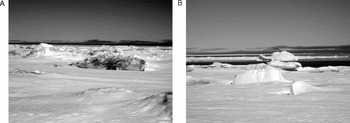
Fig. 11 Photos showing different types of multi-year ice, including: a) ‘dirty’ sikutuqaq described as coming from the south; and, b) ‘clean’ sikutuqaq described as coming from the north.
There's a reef [Ivunirarjuq] that assists in getting this ice, or this part frozen over. A lot of years the floe edge is right there, from here to about here [referring to map]. And that's a majority of the years. But some years when [ice is not piled up at the reef], the floe edge tends to stay here, right along the shore. So therefore, this pretty much determines how this ice is going to form (Ivalu Reference Ivalu2005).
Rougher ice conditions created when MYI is grounded and frozen into the tuvaq also promote snow accumulation, and can lead to dangerous travel (AQ1; DAq1; MA1; TI1). Furthermore, if this ice is blown into bays in the autumn, the bays freeze tend to freeze over earlier (EI1). Therefore, the presence of sikutuqaq in the summer can influence autumn and winter ice conditions and extent (Fig. 2) (AI1).
MYI can be identified by its weathered, smooth look (AQ1). This ice melts somewhat in the spring and summer, and then re-freezes in the autumn and winter, constantly alternating between larger and smaller sizes. But these large floating ice features are also notable for their clear bluish complexion due to salt drainage over time (AQ1; HP1; LU1). First-year ice that may have piled up over the winter can also become large, but it still looks white, indicating that it formed during the previous winter and has not yet lasted through a summer (AQ1).
Melting processes
In this section, Table 4 and Fig. 2 should be consulted as references for Inuktitut terminology and links between processes.
Table 4. Inuktitut terminology, descriptions, and brief definitions for sea ice conditions associated with melting stages (in approximate order as shown in Fig. 2).

Snowmelt
When asked about the melting of the ice, many elders and hunters began by mentioning the influence of currents ‘wearing away’ (likened to ablation) the ice from underneath, before the snow even starts melting on top. Therefore, melt stages occur from both above and below the ice surface. However, the snow cover is the visual indicator of the onset of melt stages, since it begins melting before the ice (Fig. 2) (AI1; AQ1; DAq1; DI1; EI1; LQ1; MA1). The snow would start to become smooth/shiny in certain places (SA1), and then get soft and mushy, making travel difficult (DAq1; DI1; EI1; MA1). The first stage of snowmelt is termed qinallatut, when the snow is softening and thinning (likened to crystallizing and compacting), and nanirlijuk refers to the thinning/shrinking snowpack (Fig. 2) (AI1).

Fig. 12 Photos of snowmelt conditions on the surface of the sea ice, including: a) nilaruqtuq, the ice is somewhat crystallized as it melts; and, b) ijaruvaujat, the ice forms little balls (‘like eyeballs’) in early melt stage.
The melting starts from the snow. The qinallatut is the very first stage, and then the snow can be this deep, but then when it somewhat semi-melts, it's not melting but it softens, it gets thinner as well, and that process being from that thick to this thin is called nanirlijuk (Ivalu Reference Ivalu2005).
As the snow melts it creates a crystallized film on top (that is nilaruqtuq) (fig. 12a) whereby little balls of ice form (that is ijaruvaujat) (fig. 12b) (AI1). The softening snow will then even out, and when the weather cools it will harden again. So, manguqtuq is the process of the snow beginning to melt, and evening out (Fig. 2) (AI1; EI1; LQ1; MA1; SA1). The surface will become wet and slushy under the snow (that is puimajuq), but it is not yet completely melted so it becomes very difficult to travel pulling a kamutik (sled) (MA1; NQ1). This stage is followed by qirsuqqaq, where it freezes smooth again and is good for spring travel (AI1; EI1; SA1). Once the snow starts melting again, it will continue to the point where the ice becomes waterlogged and begins to deteriorate (Fig. 2) (AI1; EI1; SA1), and the re-freezing will not occur again (SA1).
Water accumulation and drainage
Where seaweed has been swept on top of the ice, or become lodged in the ice, deep sections will form in the ice during later melt stages (AQ1; DI1). Because the seaweed is narrow and hair-like, and it absorbs the radiation of the sun, it melts the ice faster and makes dents in the ice surface (AQ1; DI1). In addition, sea ice tends to wear out/open up quickly in areas where rivers flow into the ocean (that is aktinniq), due to the influx of freshwater that increases the pace of ice deterioration due to lower salinity (Fig. 2) (AT1; EK2). River water is also thought to be warmer, and along with the fast water movement, also contributes to enhanced melting (AT1).
In general, water from snowmelt accumulates on the sea ice as part of the process referred to as immaktittuq, to the point that the ice is covered in water (that is immaktinniit, likened to melt puddles) (fig. 13a) (AI1; DAq1; DI1; EI1; HP1; LQ1; MA1; SA1). However, puktailaq may remain, where mounds of snow are still visible above the water (fig. 13b) (HP1). In areas of strong currents, patikjiuqtuq may occur, a process where the snow is melting and the water is seeping through the thin ice underneath, leaving only a layer of snow on top of the water (JaP1).

Fig. 13 Photos of water accumulation and drainage, including: a) immaktinniit, melt ponds or water-logged sea ice; b) puktailaq, the areas where snow shows above the immaktinniit; c) water accumulates on the sea ice before the aggluit and naggutiit open up to provide drainage; and, d) where water accumulates the ice will wear out, and once it melts all the way through a killaq (melt hole) is created.
Like you're traveling and there's water under the snow constantly, when it first melts. [Then], you'll notice that there's no more water under the snow, indicating the water is now seeping right through the ice, meaning that the ice is thin. And that's what you call patikjiuq, patikjiuqtuq, that's a term. Again, that's water seeping, fresh water seeping through the salt ice, in that [the ice is] not present, so that's when you can tell that you are now getting onto dangerous ice. . .[T]hese can look safer than anywhere else because [they've] got no water, but in fact the water has seeped right through the ice (Palluq Reference Palluq2005).
The waterlogged ice may last for several days (JaP1; SA1), but once cracks and seal breathing holes (aggluit) get larger, they provide drainage for the water (fig. 13c) (DAq1; DQ1; EI1; HP1; JaP1; MA1; SA1). The accumulated water drains off, and the ice becomes smooth again for a period of time, which is good for traveling (DAq1; DI1; EI1; JaP1; MA1), a process called tikpaqtuq (Fig. 2) (DAq1; EI1; HP1; MA1; SA1). Areas where the water has drained faster will leave large expanses of ice visible, and this condition is referred to as saluraq (SA1).
As the melt stages progress, thinning of the sea ice occurs in certain areas (that is sagliurtuq), water accumulates again (that is immaktipaliajuk), and some sections get very deep (that is itisiuraq) (Fig. 2) (AI1; DAq1; DQ1; DI1; EI1; HP1; JaP1; LQ1; MA1; SA1). This is especially prevalent around pressure ridges or the sinaaviniq (AI1). After this deep water stage, the ice becomes rougher and some areas wear out completely (AI1; DI1; EI1; MA1). Holes that have formed right through the ice are called killait (plural for killaq: likened to melt holes) (Figs. 2, 13d) (AI1; DAq1; LQ1; MA1; SA1). Soon after this stage the ice will be breaking up (DAq1; EI1; SA1).
Break-up
Break-up does not occur randomly, ice usually begins breaking off at aajurait or where killait have become enlarged (DQ1; HP1; LQ1; MA1). The ice will break into large pans before it breaks up fully (DQ1; HP1; MA1). The tuvaq will start wearing out first (that is tuvarliqtuq) (AI1), and then the ice starts breaking up (that is siruttiq) (MA1; SA1). Following this, the tuvaq begins to break off (that is tuvaijaqtuq) (MA1; SA1).
Around when it's melting all together you have these holes [killait] that are created on the ice, and ice is now starting to break up. The wind with the current moves the ice back and forth, so therefore it breaks it up even more. . .And then this process that's happening is called siruttiq, ‘it's breaking up.’ And then if the ice is constantly breaking off here it's tuvaijaq, ‘the tuvaq is coming off’ so [it is] tuvaijaqtuq. Whereas here it would probably be more siruttiq, where it breaks up first and then it eventually goes out (Arnatsiaq Reference Arnatsiaq2004).

Fig. 14 Conceptual model of the influences of winds on sea ice formation, movement, or decay based on interviews conducted in Igloolik.
Finally, once the tuvaq breaks into floating pieces, these become tuvaijautiit (Fig. 2) (AQ1).
Wind and current influences on sea ice
Mentioned briefly earlier in this paper, winds and currents greatly influence how and when ice forms, moves, or deteriorates. For both winds and currents, the general conditions around Igloolik are described, followed by a characterisation of their influence on sea ice.
Prevailing winds
The predominant wind direction around Igloolik is most frequently cited as being from the northwest, with the southeast being the second most predominant (Table 5). A few people also mentioned the northeasterly winds as being prevailing, but more specifically in relation to areas further east along the Baffin Island coastline (Table 5). The influences of these two important winds (northwest and southeast) on sea ice conditions or movement are summarised in the conceptual model shown in Figure 14.
Table 5. Summary of predominant directional and seasonal winds around Igloolik, and their related influences on sea ice.

Sources: AI1; AQ1;AT1; AU1; DAn1; DAq1; DI1;DQ1; EI1; EK1;EK2; HP1; JAn1; JaP1; LQ1; LU1; MA1; NQ1; SA1; TI1; ZA1
Influence of wind on ice conditions or movement
In this section, Table 6 and Fig. 14 should be consulted as references for Inuktitut terminology and links between processes.
Table 6. Inuktitut terminology, descriptions, and brief definitions for sea ice conditions associated with wind influences (in approximate order as shown in Fig. 14).

Table 7. Inuktitut terminology, descriptions, and brief definitions for sea ice conditions associated with current/tidal influences (in approximate order as shown in Fig. 15).


Fig. 15 Conceptual model depicting the influences of currents and tides on sea ice formation, movement, or decay based on interviews conducted in Igloolik. Where: ———— = general process direction, ———— = daily cycle, ———— = monthly cycle.
The prevailing northwesterly winds are discussed as following the lines of glaciation (AI1; LQ1; SA1; TI1). They are credited with bringing clear, cold weather (Table 5, Fig. 14) (DAq1; EI1; TI1). They also blow moving or unstable ice out, away from the land or sinaaq (AT1; DAn1; HP1; LQ1). Therefore, as ice is blown away the open water tends to freeze over smoothly with northwest winds (Fig. 14) (AT1; DAn1; DQ1; EI1; HP1; TI1). However, with these winds blowing there is also an increased likelihood of break-off events (uukkaqtuq) at the sinaaq (Fig. 14) (DAn1; DQ1; MA1; SA1). In addition, northwesterly winds can more easily cause uukkaqtuq during very cold weather or where there are rougher ice conditions (that is where there is more surface area for the wind to catch) (DAq1; EK2).
[I]n January when it gets really cold, I mean really cold, the ice cracks easier in that it breaks up more often, cracks are created more frequently, so this tends to break off quite often. [I] was also instructed not to hunt [around the floe edge] when it was too cold in that the cold can crack the ice, or break the ice quite easily. If you have a little bit of wind, little bit of current, then more than likely the ice is going to break. [The ice] becomes brittle, and then it starts breaking off constantly. . .(Kunuk Reference Kunuk2004b).
When the aulaniq has moved away a little, it is qimaruutisimajuq (DI1). Winds can also cause qaattuq or uukkaqtuq to occur (Fig. 14) (DAq1; EK2; MA1).
The southeasterly winds tend to counteract northwesterly winds (Table 5, Fig. 14) (AT1; DQ1). After the northwest wind blows, the southeast wind usually follows (DQ1). These blow the aulajuq or aulaniq inwards, towards land or the sinaaq (AI1; AT1; EK1; HP1; LQ1; ZA1), under which conditions moving ice can become temporarily landfast (Table 5) (AQ1; DAq1; MA1). If southeast winds are sustained, the aulaniq may stop at the sinaaq and remain touching this edge for several days: a process called qaangajuq (Fig. 14) (DQ1). However, this is a not a regular occurrence. Usually there is continual movement along this landfast/moving ice interface. Southeasterly winds also create rough ice conditions as winds force ice to pile into, and onto, solid ice (Fig. 14) (DAn1; DQ1; EI1; EK1; LQ1; SA1; TI1). When this happens the ice becomes very rough (that is sikutuqqijuq), and nearly impossible to travel on (AQ1; DQ1; SA1). Furthermore, between the rough ice features some areas may not freeze uniformly, and are thus softer and thinner, especially where snow accumulates (HP1; MA1; TI1).
And this year, the conditions are that the southeast wind has been blowing a lot in the last couple weeks. [D]ue to that it might look like this is all safe [referring to the map], but there can be spots in between the ice, the rough ice, where snow had accumulated very quickly, even before the ice had become solid. So therefore, the ice is not frozen, therefore you can get your harpoon shaft and just go through the snow and then it's soft all the way through. . .If it had frozen over at the same time without the rough ice, all of it wouldn't be dangerous at all, it would be solid all the way. . .But as it is right now with the snow having fallen, there's some spots that are dangerous to travel on (Paniaq Reference Paniaq2004).
Such rough ice conditions created by SE winds can, therefore, enhance the danger of nearby ice travel, as well as influence the melting process in the spring. When the ice moves out again, the rough ice that remains on the tuvaq at the sinaaq is called nipititaaq (Fig. 14) (AQ1; EK2).
And then the ice would be temporarily stuck to the floe edge, that moving ice, and then if it breaks off, just with that rough ice remaining onto the landfast ice. . .[it would be called] nipititaaq, the rough ice that was created by the southeasterly wind. If some of it is left behind and it breaks off, that's what is called nipititaaq (Qrunnut Reference Qrunnut2004).
This ice can also be too rough to enable travel or access to the aulaniq (EK2).
Seasonally, when the wind is not blowing, and the temperatures cool in the autumn, the sea ice will freeze over quickly (Fig. 14) (AI1; AQ1; JAn1).
And also the wind plays a factor in the formation of ice in that whenever it's windy, quite often the ice tends to be rougher than when there is no wind. If there is no wind, with just the current being the only factor then it would have frozen over smoothly, and it would have frozen over quite well. But with the wind it keeps breaking [the sea ice] and piling it so therefore it becomes rough and the ice forms at a later date (Qamaniq Reference Qamaniq2004).
In the early stages of freezing, there are sometimes smooth, narrow sections that show up on the water despite the fact that the wind is blowing. They follow the direction of the wind, and are called quvviquat (Fig. 14) (AU1; DI1; EK1). In addition, the ice can freeze in an upwind direction (regardless of where the wind is coming from): a process termed aggurtipaliajuq, ‘it's progressing towards the wind’ (Fig. 14) (AI1; DI1; EI1; EK1). This freezing action results in ice that is softer than siku (EK1). In addition, winds can carry new ice to certain areas where it accumulates, and thus where freeze-up may begin earlier due to the higher ice concentration (HP1).
It is mainly when the sea ice is thin that the wind is influential on ice conditions (DAn1; AQ1; NQ1). Winds can more easily move, or break, thinner ice. When the ice is still relatively thin, the wind can cause it to hit other ice (for example from aggurtipaliajuq), where it might break, pile, and even stand upright (that is iilikulaak) (Fig. 14) (DAn1; EI1; MA1). This ice roughness is noticeable, but it is still possible to travel through (EI1). A generic term for rough ice is maniilaq (EK1; SA1), whereby ivuit are likened to pressure ridges (created by the process of ivujuq) (AI1; EK2; GQ1) and qaliriiktinniit are created when ice is overlapping (AI1; DQ1). Therefore, windy conditions during freeze-up tend to lead to rougher ice conditions (Fig. 14) (MA1; NQ1). Winds can also expedite the break-up process (Fig. 14). During a windy spring the ice will break up faster, whereas if it is calm the ice will remain intact longer (ZA1). In addition, warm spring winds melt the ice faster than calm sunny conditions (JAn1; JaP1).
Tidal cycles and currents
The general ocean circulation around Igloolik is governed by the waters flowing through the Labrador Narrows (AI1; AT1; AU1; Ikummaq Reference Ikummaq2004b (TI2)). Therefore, the tides generally come in and out in an east/west alternating pattern, every six hours (AU1: DI1). However, over the course of a day, it is noted that currents are stronger as they travel eastwards through the narrows, and not as much water will travel back in the opposite (westward) direction (AI1; AT1; EK2; MA1; TI2). Therefore, it seems that for approximately 14 hours (60% of the time) water is traveling eastward, and approximately 10 hours westward (40% of the time) (AI1; AT1; TI1). The tidal variations influence the direction in which ice travels, as well as the stability of ice conditions (AU1; TI1). Furthermore, the currents are strongest when the moon is new, or full, every two weeks (DAn1; DQ1; LU1; TI1). At these times of the month the tides peak at their highest and lowest levels, and are especially influential on ice conditions (Fig. 15) (DAn1; DQ1; LQ1; TI1). This ‘full moon effect’ is referred to as piturniq (LU1).
A full moon and a new moon creates these, when the current gets stronger the ice cracks because the ice moves a lot. It has to have a certain give. [S]alt water ice can stretch so much and then it breaks. So therefore these cracks are created at a new moon and a full moon. So every two weeks, at about every two weeks a new crack, the same crack is opened up and then it adds, and it freezes over (Ikummaq Reference Ikummaq2004a).
Interestingly, the day after the full or new moon, just as it is starting to change size, is actually when the currents are strongest, not necessarily on the day of the full moon itself (DAq1). Furthermore, it was mentioned that the autumn and spring equinox bring the strongest full/new moon effect (SA1). In addition, the strength of currents is said to vary between years (AI1; JAn1; LQ1; TI1; ZA1).

Fig. 16 Map showing the locations of key aukkarniit around Igloolik and within Ikiq. Sources: AI1; AT1; AU1; DAq1; DI1; DQ1; EI1; EK2; GQ1; HP1; JaP1; LQ1; LU1; MA1; NQ1; SA1; TI1; ZA1.
Current and tidal influence on ice conditions and movement
In this section, Table 7 and Fig. 15 should be consulted as references for Inuktitut terminology and links between processes.
Where currents are strong, the fast flowing waters prevent ice formation (Fig. 15) (AU1; DAq1; EI1; LQ1; LU1). This is often the case between islands, or between islands and the mainland (AT1; AU1; DAq1; JaP1; NQ1; TI1; ZA1). Stronger currents also contribute to the formation of aukkarniit (likened to polynyas) (DQ1; EI1; HP1; ZA1) and influence the position of the sinaaq (Fig. 15) (AI1; ZA1). Current strength is also linked to water depth. Deeper areas have weaker currents than shallower areas (TI1). Currents can cause ivujuq, or contribute to the formation of iilikulaak, thus leading to rougher freezing (Fig. 15) (AI1; EI1; EK2; GQ1). Furthermore, where currents are stronger they will contribute to more ice movement during freezing, which leads to the formation of circular ice pans that are smooth in the middle and rougher around the edges (that is aksajutak, likened to pancake ice) (Fig. 15) (NQ1).
On the other hand, areas with weaker currents freeze over at an even pace and thickness, meaning that they are safer throughout the duration of the winter (DAq1).
The term aukkarniit (plural for aukkarniq) is used to refer to areas of open water, in where currents erode the ice from below (Fig. 15) (DQ1; HP1; MA1; NQ1; TI1). These areas may freeze temporarily in the winter, but they maintain the same name (SA1). However, certain aukkarniit also have specific names, identifying important individual polynyas. There are several key aukkarniit within Labrador Narrows, Aukarnaqjuaq (‘large polynya’) being the largest and most centrally located (Fig. 16) (AU1; EI1; HP1; LQ1; SA1; ZA1). Also in the vicinity, Akuliqpaq (‘in the middle’) and Kangiliqpaq (‘furthest’ towards the mainland) remain open in the autumn, but often freeze over at a certain point in the winter (Fig. 16) (AU1; EI1; HP1; SA1; ZA1). Aukarnarjuq (‘small polynya’) is another important aukkarniq at the mouth of Murray Maxwell Bay (Figs. 16, 17a, b) (HP1; SA1; ZA1). The rate of freezing is dependent on the strength of currents. Where the currents are stronger, aukkarniit will remain open longer (AI1; EK2; LQ1; TI1; ZA1). However, even if these, or similar, areas do freeze over, there is always danger traveling in such areas (Fig. 15) (AI1; AU1; DI1; LQ1; ZA1). Any narrow channels tend to be dangerous because of the strong currents flowing through (AT1; AU1; NQ1). These same areas also tend to open up earlier in the spring than where there is more solid ice cover (AT1; JAn1; NQ1; SA1; TI1; ZA1).

Fig. 17 Photos showing various views and dynamics around Aukarnarjuq, including: a) view of the south end of Aukarnarjuq from a nearby hill, looking east from the west side; b) traveling beside Aukarnarjuq; c) ukpittuq, the process of the ice being pushed into the edge of the aukkarniq by the current, breaking off, and sinking underneath; and, d) kaniq, a slowly rising ice ‘mound’ created by the accumulation of ice at the northern end of Aukarnarjuq.
The continual water movements in aukkarniit render them ever changing in size, shape, and stability. For example, there are always pieces of ice breaking off the edge, being carried with the current, and then being pushed under the ice at the other end of the aukkarniq (DI1; ZA1). The same term is used for this breaking off process as at the sinaaq (that is uukkaqtuq) (Fig. 15) (DI1). So, there is a continual cycle of thin ice forming on the aukkarniq, breaking off, being pushed under the edge, ice reforming, etc. This can sometimes lead to an accumulation of ice underneath the surface at one end of the aukkarniq (DI1; EI1). This ongoing pressure at one end can cause ice to break in the direction the current is traveling (that is ukpittuq) (Figs. 15, 17c) (DI1). This can rapidly increase the size of an aukkarniq (ZA1). However, the ice accumulation can also mean that the edges of aukkarniit become thicker than the surrounding sea ice, as the ‘current swallows the ice’ (that is iijaujuq) (Fig. 15) (EI1). In addition, a kaniq is a unique formation created by Aukarnarjuq, at the mouth of Murray Maxwell Bay (Figs. 15, 16, 17d) (DAq1; DI1; EK1; JaP1; MA1). The kaniq is created when new ice that is forming gets ‘eaten’ by the currents and pocketed on the northern end of Aukarnarjuq (DAq1; DI1; EK1; JaP1; MA1). Ice movement is halted at this end because of the relatively weak current in Murray Maxwell Bay, which causes the ice to accumulate into a low mound from underneath (EK1; JaP1; MA1). Because of continuous water movements the ice does not freeze solidly, but it remains structured because of the ice accumulation (DAq1). Therefore, it can look relatively safe, but people can sink right through if they are traveling on it (DAq1; DI1; JaP1; MA1). Furthermore, cracks in that area can be soft all the way down, even though the ice may be solid on either side (DAq1; DI1; EK1; JaP1; MA1).
There is a time in the winter, when [Aukarnarjuq] gets ice-covered, when the tide is going this way [south] it gets ice covered, and then all of a sudden the tide shifts and the ice is now moving the other way [north] and it gets eaten by the current. Therefore, it stops underneath the ice here and creates this mound [kaniq] from underneath. The ice is packing [in] whenever the tide is going in. So therefore, it piles up, becomes a big mound, and then at the rim of this mound there can be cracks, but being snow-covered you wouldn't be able to know that there's a crack there. And then at that crack it would be soft all the way to the bottom. It's not frozen, it's ice but it's not frozen at all. . .It's ice that's forming, but it breaks off here as well. So whatever ice breaks off it just gets under the ice and then it stops here because this is hardly any current at all. This is strong in current, but the current stops here, there's hardly any in Murray Maxwell Bay (Arnatsiaq Reference Arnatsiaq2004).
The monthly new and full moons are a primary cause for the formation, and re-formation, of tidal cracks throughout the winter and spring (Fig. 15) (DAn1; DQ1; EI1; EK2; JaP1; SA1; TI1; ZA1). The ice will crack open every time the current strengthens, it will re-freeze, and then crack again two weeks later with the next strong tide (DQ1; EI1; TI1). These times of the month there is also an increased probability of uukkaqtuq at the sinaaq (Fig. 15) (AI1; DI1; LU1; TI1; ZA1). This is especially of concern during the very cold winter months (January/February), when the ice tends to crack or break more easily (DAq1; DI1; EK2; ZA1). During the transitions between new and full moons, the currents are not as strong and thus the ice freezes at a relatively even pace (LU1). When these processes occur in the spring, the ice tends to crack but not re-freeze, resulting in the formation of aajurait (Fig. 15) (TI1).
Currents play an influential role in melting the sea ice, as they are described as ‘wearing away’ the ice surface from underneath (Figure 15) (AQ1; DAq1; DQ1; EI1; EK2; JAn1). This is one of the reasons why some early melt stages are difficult to discuss, because they are not visible (AQ1; DAq1; DQ1). The snow may not even be melting on the land or ice, and yet the currents are eroding the ice from underneath (AT1; DI1; DQ1; EI1; EK2; JaP1; MA1; SA1), rendering it dangerous for travel (DAq1; DI1; MA1). This process is named nunguppaliajuq, ‘it's wearing out from underneath,’ and this can even occur during the winter when there are overcast weather conditions (Fig. 15) (EI1). Once the snow on the ice begins to melt, and water is accumulating on the ice, areas with stronger currents may already be opening up (DI1; DQ1). Furthermore, the currents actually seem to be stronger in the spring than in the autumn (JaP1), and can be more influential on the melt processes than the sun (JAn1).
When the tide is coming, it will bring aulajuq towards the land or sinaaq (Fig. 15) (AU1; DI1; HP1). Similarly, if the tide is going out, it will take the aulajuq with it, away from the land or sinaaq (AU1; DI1; HP1). It was noted that rough ice can be particularly influenced by the currents due to underwater ice topography. It is recognised that the majority of a piqalujaq, or a pan of sikutuqaq, is submerged underwater (EK2). Therefore, the greater the underwater roughness the more protruding features that can be caught within flowing waters, and thus moved by the currents (AQ1; EK1; EK2). This means that larger, rougher aulaniq can be more easily affected by currents, thus creating rougher ice along the sinaaq as thicker pieces of ice will collide and pile up into heaps (EK1; TI1). Consequently, even when large pieces of sikutuqaq are lodged within tuvaq, especially around aukkarniit, they are to be avoided because the currents become funneled around their underwater girth, wearing away the sea ice that has encircled the large ice (EK1; EK2).
[E]ven before the snow starts melting, wear happens from underneath. The ice gets worn out from underneath from the currents. And the structure of rough ice, where it's rough on the surface and again, the majority of that ice being submerged. . .more than likely it's rough for quite a ways down. And the ice, having places where it tapers down into the water, those would create turbulence from the current. Therefore, where there's snow that's sheltering the ice, with the turbulence doing the action from underneath, the water moving in circles and wears out the ice underneath that snowbank. So the ice can be gone even though the snowbank looks like it never changed. [There was] an incident once here [referring to the map], where [I] was traveling and [I] was starting to notice that the snowbanks, some places it was dark, it was black, on the rim of the snowbank, in that now this was water. Once [I] started noticing that [I] had to go back even before [I] got to where [I] wanted to hunt for seal. . .And this is at the time when the ice is not forming anymore. It's not melting mind you, but it's not forming anymore (Kunuk Reference Kunuk2004b).
As described in the above quotation, snow accumulation around larger ice formations insulates the ice, and enables the currents to erode the ice more effectively from underneath (EK1; EK2; TI1; ZA1). This creates dangerous travel conditions.
Discussion and conclusions
In using sea ice extensively for travel and hunting purposes, Inuit elders and hunters in Igloolik have developed a detailed and nuanced understanding of freezing and melting processes. Specific Inuktitut terms are used to describe various ice conditions and transition stages that occur throughout the annual sea ice cycle of formation and decay. These also link to tidal cracks, the floe edge, moving ice, and polynyas, as influenced by wind and current conditions. Such characterisations of freeze/thaw and dynamic processes provide a unique glimpse into the localised conditions and marine geography of the sea ice surrounding Igloolik, and extending across Fury and Hecla Strait. This local scale understanding is critical for Inuit elders and hunters in evaluating ice conditions related to travel safety and marine wildlife hunting/habitat (Laidler and Elee 2006). Beyond community-based applications, these results also have the potential to inform future research efforts on: i) local/regional sea ice monitoring; ii) the relationship between Inuit knowledge, language, and the environment; and, iii) addressing community interests through targeted studies.
First, Laidler and Elee (2008) highlight that sea ice monitoring is often undertaken at coarse spatial scales using remote sensing technologies. In the context of such studies, Igloolik is included within the regional delineation of Hudson Bay (Mysak and Manak Reference Mysak and Manak1989; Wang and others Reference Wang, Mysak and Ingram1994; Mysak and others Reference Mysak, Ingram, Wang and Van Der Baaren1996; Parkinson and others Reference Parkinson, Cavalieri, Gloerson, Zwally and Comiso1999; Parkinson Reference Parkinson2000), and the trends in ice coverage and freeze/thaw processes do not adequately capture the dynamics and ice movement in Fury and Hecla Strait, or Foxe Basin. Heide-Jorgensen and Laidre (Reference Heide-Jorgensen and Laidre2004) do provide a subset analysis of the fraction of open water present in sea ice around Igloolik, which is useful in evaluating regional sea ice trends for northern Foxe Basin. However, this data is still not easily translated into meaningful information that can be used locally to evaluate ice conditions within the vicinity used for travel and harvesting. A few notable exceptions include: i) Anders’ (1965) local characterisation of Fury and Hecla Strait ice conditions and freeze/thaw processes/timing based on in situ observations and measurements around Igloolik; and, ii) the report of Smith and Rigby (Reference Smith, Rigby, Stirling and Cleator1981) on the distribution of polynyas during seasonal freeze/thaw (1975–1979) in the Canadian Arctic (with Foxe Basin included as one of the study areas). Both of these exceptions are evidently temporally constrained, and thus may not be directly relevant to contemporary sea ice conditions and uses. However, they do highlight some important parallels, and notable divergences, with results presented in this paper. One particular example is the consistency with which interviewees, Anders (Reference Anders1965), and Smith and Rigby (Reference Smith, Rigby, Stirling and Cleator1981) describe/depict the shore lead present along the northeastern coast of Melville Peninsula. Each description emphasises the influence of wind direction and strength, along with ocean circulation and tidal fluctuation, as affecting the width or presence of this lead. Furthermore, the maps provided by Smith and Rigby (Reference Smith, Rigby, Stirling and Cleator1981) show a similar floe edge delineation as in Fig. 9a, and additionally depict areas of open water/moving ice further east (to Rowley Island and beyond) that were described by elders and hunters but not captured due to map extent limitations during interviews. However, some deviations arise in the scale/characterization of polynyas, where aukkarniit located by interviewees (Fig. 16) are generally not mapped in Smith's and Rigby's (1981) report. So, the important open water (and dangerous) areas that elders and hunters emphasise within the Labrador Narrows, along with other small-scale polynyas (although Aukarnarjuq does seem to appear in their February, 1977 map), are either: i) too small to be considered polynyas by sea ice scientists or image interpreters; or, ii) too small to show up on the coarse resolution NOAA imagery. Either way, this discrepancy is an important basis for future investigations into Inuit and scientific definitions of ice features/conditions, and the scales most appropriate to monitor these. Because hunters are the experts on localised ice conditions, there may be new opportunities for collaboration in which local monitoring programmes, such as described in Tremblay and others (Reference Tremblay, Furgal, Lafortune, Larrivée, Savard, Barrett, Annanack, Enish, Tookalook, Etidloie, Riewe and Oakes2006), could be implemented to complement regional-scale satellite image acquisitions (for example Meier and others Reference Meier, Stroeve and Gearheard2006). We are already pursuing avenues to link local observations of change to time series created through Canadian Ice Service (CIS) ice chart analysis, and are finding a need for additional research into definitions of freeze-up and break-up. For example are the standard 5/10 definitions appropriate in a local context and which particular environmental variables might be most useful to contribute to regional monitoring or simulations of future sea ice trends (such as precipitation (especially snow accumulation), overcast weather, air/ocean temperature, wind speed or direction, etc.).
Second, Laidler and Elee (2008) summarise some of the landmark studies undertaken in Nunavut on the relationship between Inuit knowledge, language, and the environment. Here, direct links can be made between results in this paper and previous oral history, placenames, and navigational skills research undertaken in Igloolik (MacDonald Reference MacDonald1998; Aporta, Reference Aporta2002, Reference Aporta2003, Reference Aporta2004). The important combination of engaging with the sea ice environment and using the Inuktitut language is critical in the development of skills required for safe navigation of the dynamic sea ice cover around Igloolik. This is reflected in the terminology discussed, where the number of terms used to describe specific ice conditions along the sinaaq, at the interface between moving ice and the floe edge (that is aulaniq), highlights the danger and dynamism involved with traversing this area to reach the moving ice (that is aulajuq). This dangerous destination is important because it is where walrus (Odobenus rosmarus; aiviq in Inuktitut) hunting takes place, a unique harvesting activity conducted by hunters in Igloolik (Aporta Reference Aporta2002). Furthermore, many of the sea ice terms incorporate descriptions of the process that is occurring with the movement of sea ice. So, by understanding, and being able to identify, the ice conditions with which the terms are associated, hunters are able to use the sea ice environment with enhanced comprehension and safety. Winds were emphasised as especially influential on the movement and position of the aulaniq. Wind directions and uses in sea ice navigation are further elaborated upon in MacDonald (Reference MacDonald1998) and Aporta (Reference Aporta2002). Combining these more detailed wind/navigation analyses with sea ice terminology and condition analyses here, could produce an enriched understanding of the relationships between Iglulingmiut (people of Igloolik), their (changing) uses of the sea ice, marine geographies, and the evolution of the local Inuktitut dialect. As in Laidler and Elee (2008), we hope that documenting sea ice terminology in Igloolik also contributes to broader efforts to preserve languages, knowledge, and culture of the north (Dorais and Krupnik Reference Dorais and Krupnik2005; Ford and others Reference Heide-Jorgensen and Laidre2007), an aspect of similar concern to the elders and hunters of Igloolik.
Finally, as in Laidler and Elee (2008), an improved understanding of locally important sea ice conditions could help create targets around which to develop future research. One example is the use of documented Inuit knowledge of sea ice as a foundation upon which to develop educational resources. In Igloolik, community members reiterated the importance of knowledge documentation as a means of enabling their expertise to be represented in writing, and on maps (Laidler Reference Laidler2006b). Beyond simple documentation, incorporating Geographic Information Systems (GIS), Global Positioning Systems (GPS), Inuktitut terminology and descriptions, photos of sea ice conditions, audio and video footage of interviews and sea ice trips, and written transcripts/reports with emerging multimedia and interactive technologies has great educational potential. An excellent example of this has been compiled for Igloolik by NRI (2006), and within Fox (Reference Fox2003) there is a substantial Igloolik component. In NRI (2006), there is a specific sea ice section within the interactive CD-ROM. This depiction of the uses of sea ice, as well as different ice types, travels, and terminology, highlight the value of interactive learning. For example, with animations of sea ice freeze-up stages, it is easier to visualise the progression from qinu, to quvviquat, to sikuaq, to nigajutaq, to sikuriaq, to qaliriktinniq, and finally to tuvaq. Also, listening to the oral descriptions of elders and hunters provides added context and important dimensions of expression to the selected quotations. As useful are video descriptions/demonstrations of ice types, safety, dynamics, and wind/current influences, where language, sea ice, gestures, expression, and expertise come together. Undoubtedly, interactive multimedia, much less written documentation, cannot replace the type of experiential learning and knowledge transmission that takes place when traveling on the sea ice with experienced elders or hunters, and learning by doing (Aporta Reference Aporta2004, Reference Aporta2005; Aporta and Higgs Reference Aporta and Higgs2005; Takano Reference Takano2005; Ford and others Reference Ford, Pearce, Smit, Wandel, Allurut, Shappa, Ittusujurat and Qrunnut2007; Laidler Reference Laidler2007). However, it does provide an important bridge between: i) textual knowledge documentation and engaged practical learning; ii) long-term experiential in situ learning of more traditional times and formal text-based learning of the southern-style education system in Nunavut; and, iii) classroom learning and field schools. The results presented in this paper have the potential to contribute directly to such efforts, and expand northern (and community-specific) interactive educational materials in their terminology and environmental characterisation depth and specificity.
A second example would involve applications related to wildlife management, including the assessment of wildlife habitat, behaviour, and health. We have started making these links, in which interactions between sea ice formation/movement/decay and marine wildlife habitat are explored. However, the main focus of that paper is on human (safe) use of the sea ice to harvest ringed seals (Phoca hispida, natsiq in Inuktitut) and walrus, especially in the face of changing sea ice conditions. Currently, work is taking place to expand the application of the existing results to inform: i) additional analysis related to Inuit knowledge of the importance and uses of sea ice for/by marine mammals; and, ii) research into food security (that is access to, and availability of, country food). Furthermore, this type of detailed local sea ice characterisation, and related wildlife expertise, could contribute to discussions of wildlife management surrounding harvesting quotas for different marine species (Ford and others 2007). The local scale is an important complement of scientific studies and monitoring efforts (Moller and others Reference Moller, Berkes, Lyver and Kislalioglu2004; Laidler Reference Laidler2006a), but one that sometimes does not have enough documented material, or decision-making respect, to secure equal consideration in decision-making related to wildlife management (Collings Reference Collings, Smith and McCarter1997; Gilchrist and others Reference Gilchrist, Mallory and Merkel2005). In the case of Nunavut wildlife co-management, there are certainly increased opportunities for Inuit expertise to be considered alongside scientific expertise (for example Nakashima Reference Nakashima and Inglis1993; Kilabuk Reference Kilabuk1998; NWMB 2000; Armitage Reference Armitage2005; Diduck and others Reference Diduck, Bankes, Clark, Armitage, Berkes, Huebert, Fast, Manseau and Diduck2005; Kristofferson and Berkes Reference Kristofferson, Berkes, Berkes, Huebert, Fast, Manseau and Diduck2005), and we hope that additional community-based studies such as this one can continue to contribute essential baseline information to such joint management practices.
A third and final example relates to community interest in climate (and related sea ice) change. As summarised in Laidler and Elee (2008), Inuit and scientific expertise could provide complementary perspectives on similar phenomena at different spatial scales, while also providing enhanced understanding of how such changes may affect socio-economics and the sustainability of northern lifestyles and culture. Ford and Smit (Reference Ford and Smit2004) describe an approach to assessing community vulnerability to climate (or related) change that promotes the characterisation of current/future exposure and adaptation from both physical and social perspectives. Their approach would start with indicators and factors identified as important by the community, and then employ natural and social sciences to develop a comprehensive picture of how these aspects change (and interrelate) to lead to local vulnerability or resilience. This approach necessitates collaboration with community members and organisations from the outset, and local Inuit experts have much to contribute in this realm of investigation. Such community-specific knowledge has been recently emerging in the literature (Aporta Reference Aporta2002; Ford and the Community of Igloolik Reference Aporta2006; Ford and others Reference Ford, Riewe and Oakes2006). These papers highlight some important indicators used by Igloolik hunters to evaluate sea ice safety, and change over time, including: i) the location/dynamics of the sinaaq (floe edge); ii) the timing of freeze-up and break-up, and the duration of these transitional periods; iii) sea ice thickness; iv) the influence of weather (for example overcast conditions, wind speed and direction) and snow accumulation on ice formation/deterioration; and, v) the location/dynamics of aukkarniit (polynyas). Such local characterisations help to contextualise changes that are currently being experienced by community members (Ford and others Reference Ford, Smit, Wandel and MacDonald2006; Laidler Reference Laidler2007), and provide potential indicators with which to target future monitoring or change assessment research to reflect community interest. We have begun to explore these linkages, with remarkable consistency arising between local observations of change and time series analysis of CIS ice charts for: freeze-up and break-up timing, and length of the ice-free season. In addition, local expertise contributes to evaluating the impacts of such change on marine mammal habitat and behaviour, hunting success, hunting safety, and food security. Factors taken into consideration in local assessments of ice safety or variability could also serve to refine the variables used in time series analysis, or develop monitoring programmes that better evaluate locally meaningful indicators.
Through this discussion, efforts have been made to highlight a few of the ways that community-based sea ice research can contribute to a broader context of northern research or community initiatives. As in Cape Dorset, community members in Igloolik want to work with researchers, and to have their expertise considered alongside scientific expertise, especially where addressing local interests or concerns (Laidler Reference Laidler2006b). Working together is essential to understanding the potential implications of sea ice change for northern peoples and environments, but working together must start by mutual understanding. Therefore, it is hoped that this paper provides a starting point for future cross-scalar investigations that would incorporate marine environmental trends, wildlife and human health, socio-economic implications, and socio-cultural perceptions/connections as interrelated with the sea ice environment around Igloolik.
Acknowledgements
We are grateful for the support and collaboration of community members and local organizations in Igloolik that made this research possible, most notably the elders and hunters who shared their knowledge through interviews and sea ice trips. Special thanks also goes to the Hamlet of Igloolik, the Igloolik Hunters and Trappers Association, the Nunavut Research Institute (Igloolik Branch), the local Qikiqtani Inuit Association, and the Government of Nunavut Environment Department which helped facilitate this work and/or provided interview and meeting space. Interviews conducted were in compliance with ethical protocols at the University of Toronto, and were conducted under a multi-year Nunavut Research License (#0100504N-M, January, 2004–December, 2006). Financial support for this research was provided by the same sources listed in Laidler and Elee (2008).


