


Introduction
The goal of the 1845 Franklin expedition was to map and complete the first transit of the northern coast of North America, an area commonly referred to as the Northwest Passage. The expedition was commanded by Sir John Franklin, RN and was comprised of two Royal Navy vessels, the HMS Erebus and HMS Terror. HMS Terror was under the command of Captain Francis Crozier and Erebus was captained by James Fitzjames (Woodman, Reference Woodman1991). The vessels left England in May 1845 and, after being sighted in Baffin Bay in July 1845 by whalers, neither ship nor any of the 129 crewmen were ever seen or heard from again by contemporary Europeans (Cyriax, Reference Cyriax1969).
The first evidence of what happened to the expedition came in 1850 when it was learned from the gravestones of three Franklin crew members that the ships had overwintered in 1845–1846 at Beechey Island on the south coast of Devon Island (House of Commons and Command, 1851). In 1854, Dr John Rae, working for the Hudson Bay Company, encountered a group of Inuit near Pelly Bay from who he learned that most the Franklin crew had died of starvation along the shores of King William Island (KWI) (Rae, Reference Rae1889). In 1859, Captain Francis McClintock and members of the Fox Expedition (1857–1859) reached KWI and recovered a note left by Crozier and Fitzjames at Victory Point (McClintock, Reference McClintock1860). From the note it was learned that the ships had become trapped in the heavy ice northwest of KWI in September 1846. In an addendum to the note made in April 1848, it was learned that the expedition had deserted their ships with the intent to travel overland to reach the Back Fish River. Critically, the addendum reported that, ‘Sir John Franklin died on the 11th June, 1847’.
In 1860, Charles Francis Hall launched the first of two expeditions believing it was his calling to uncover what had happened to the Franklin expedition (Hall, Reference Hall1864). Hall planned to travel to Baffin Island, hire Inuit to serve as guides and interpreters, and then travel to KWI. Hall did not reach KWI during his 1860–1862 expedition, but befriended an English-speaking Inuit couple, Ebierbing (E-bier-bing) and Tookolito (Too-koo-li-too), who would travel with him on subsequent journeys. Hall returned to the Arctic in 1864, where during the next five years he interviewed Inuit who had encountered members of the Franklin expedition.
In the spring of 1866, Hall had several interviews with an Inuk from the Boothia Peninsula named Su-pung-er. Three winters prior, Su-pung-er and his uncle reported that they had visited the north end of KWI to search for objects left by the Franklin crew (Fig. 1). Su-pung-er told Hall that there was an underground burial site or ‘vault’ on KWI. Su-pung-er's testimony included a description of a wooden pillar, tightly fitting stones and a human skull near the vault. Hall recorded the testimony in his travelling note books and private journals (Fig. 2) and in letters sent to his sponsors, which are now housed at the Archives Center, National Museum of American History, Smithsonian Institution (Washington, DC, USA). Unfortunately, Hall died prior to publishing the findings of his second expedition. When Hall's biographer J.E. Nourse edited and published Hall's journals in 1879, Su-pung-er's testimony was limited to a few short paragraphs with minimal mention of his descriptions of the vault found on KWI (Hall & Nourse, Reference Hall and Nourse1879). The first detailed report of the Su-pung-er testimony did not come until 112 years later, when David Woodman published a brief report describing what Su-pung-er had observed (Woodman, Reference Woodman1995b).

Fig. 1. Map of King William Island showing the reported path travelled by Su-pung-er, and the possible paths of HMS Erebus and HMS Terror and the Franklin crew.

Fig. 2. a. and b. A journal in which Hall designated ‘Hall, C.F. Sir John Franklin Book – Continuing information gained from time to time of the Innuits relative to Franklin's Last Expedition by C.F. Hall, Repulse Bay’ (Hall, Reference Hall1868a). c. Journal kept by Hall Reference Hall1866, May–June 1866 (Hall, Reference Hall1866d). d. Journal ‘B’ kept by Hall during the time he spent with the Esquimaux during his second expedition in December 1868 (Hall, Reference Hall1868b). e. Hall's field notebooks.
During Hall's second expedition, Hall hired Peter Bayne, Patrick Coleman and several others from the nearby whaling fleet to gather food for him in preparation for his trip to KWI. While Hall was away from camp, the hired whalers interviewed an Inuit couple from Pelly Bay and learned of their interactions with the crew of the Franklin expedition. When Hall returned to camp, and for reasons which remain unclear, Hall claimed that Coleman was in the process of staging a mutiny and thus Hall shot and killed Coleman. Based upon the Pelly Bay Inuit's testimony, Bayne claimed to know where Franklin was buried in a vault-like structure on KWI (Scientific American, 1913).
Like Hall's report, the testimony gathered by Bayne was not disclosed in full until after Bayne's death (Burwash, Reference Burwash1931). However, a 1913 newspaper report indicates that Bayne purchased the schooner Duxbury and intended to use it to sail to KWI to search for the ‘Franklin vault’ (Morning Oregonian, 1913; Scientific American, 1913). Later, a 1930 newspaper report suggested that two men, George Jamme and T.W. ‘Judge’ Jackson, had befriended Bayne before his death and had learned the location of the vault and intended to seek its location (Evening Post, 1930). While performing a survey of the north for the government of the Northwest Territories, Major L.T. Burwash was instructed to visit KWI to seek evidence of the vault based on the Jamme report (Burwash, Reference Burwash1931).
To date, the Franklin ‘vault’ has not been found. Furthermore, to our knowledge, the complete testimony of Hall's interactions with Su-pung-er has not been published. Recently, both HMS Erebus and Terror were located, based in part on testimony provided by Inuit who had encountered members of the Franklin expedition. The finding of Erebus and Terror has significantly bolstered the view that Inuit testimony is generally reliable based upon their observations. Therefore, the purpose of this paper is to publish Hall's notes focused on Su-pung-er's vault testimony, and to compare these findings to those reported by Bayne. It is our hope that in so doing the final major archaeological site of the Franklin expedition may at last be located.
Transcription of testimonies
The Charles Francis Hall Collection is housed at the Archives Center, National Museum of American History, Smithsonian Institution. On 7–8 October 2015 and 4–5 November 2015 the collection was accessed to record material that has not been published in its entirety. The collection constitutes a vast array of documents ranging from loose notes, bound books and field journals containing both notes of the day and navigational calculations (Fig. 2).
Hall kept several journals focused on the Franklin expedition in which notes pertaining to his encounters with Su-pung-er are recorded. The majority of these encounters were recorded in ink in a bound journal labelled by the Smithsonian as ‘Journal kept by Hall Reference Hall1866, May–June 1866’ (Fig. 2c), (Hall, Reference Hall1866c) and a journal in which Hall designated ‘Hall, C.F. Sir John Franklin Book – Continuing information gained from time to time of the Innuits relative to Franklin's Last Expedition by C.F. Hall, Repulse Bay’ (Fig. 2a,b) (Hall, Reference Hall1868a). Two further journals provided additional source material: (1) journal ‘A’ kept by Hall during the time he spent with the Esquimaux during his second expedition in December 1868 (Hall, Reference Hall1868b), and (2) journal ‘B’ (Fig. 2d) kept by Hall January–July 1869 (Hall, Reference Hall1869). Additional information was also gathered from many of Hall's field notebooks (Fig. 2e) (Hall, Reference Hall1866b, Reference Hall1866c, Reference Hall1866d, Reference Hall1866e, Reference Hall1866f, Reference Hall1866g, Reference Hall1866h, Reference Hall1866i). Images were taken of most of the collection material comprising the second Hall expedition for later transcription.
Several spellings for Su-pung-er are used by Hall in his notes including Sŭ-pung-er, Su-pŭng-er, Supunger and Su-pung-er. The spellings that Hall used in his journals are recorded as written although Su-pung-er is used outside of the transcriptions as it was most frequently used. In addition, Hall frequently used the symbol ‘+’ to mean ‘and’, and used abbreviations in his notes, including Encn. (encampment), wh. (which) and N. (north). Where possible, the abbreviations and symbols are transcribed as written and modern spellings are included (for example, Inuit versus Innuit). As near as possible, Hall's punctuation is reproduced in the transcription. Brackets have been added by the authors for missing words or for clarification.
Transcription from the ‘Journal kept by Hall, 1866 May–June 1866’ focused on the Franklin expedition (Fig. 2c) (Hall, Reference Hall1866a)
-
Thursday May 3, 1866.
-
40th Encn. on the ice of the sea of Ak-koo-lee on the snow village of Kok-lee anng-nŭn + his people.
-
Lat. N.
-
Long W.
-
IV h P.M. This is the 1st moment I have felt like touching pen or pencil since late at night of Thursday. Indeed, now I feel unfitted in body + mind to do anything of the kind of work I am now doing. But a record of the [preceding] events must be made + there is no one here to make them but my own poor self.
-
At once I may put down one terrible fact - a fact that has overwhelmed me in grief - but not in despair - that no further progress can be made by me at present toward the point of my destination from the fact that Nŭk-er-zhoo & Ar-mon refuse to proceed further, but not without using good reasons. As for E-bier-bing & Too-koo-li-too they are willing to continue on with me if I say so, but after weighing all the information I have gained, I cannot be so reckless of their lives as to demand it.
-
As well as I can I will make record of what transpired yesterday (Wednesday May 2nd). In my pencil notes of Thursday it will be seen that the people whom we first met on that day told such alarming stories to my Inuit's Co. that the prospects of my further advance toward King William's Land seemed anything else than good. On Wednesday morning (yesterday morning) E-bier-bing came into my igloo + told me that Nŭk-er-zhoo & Ar-mon wanted to have me meet the Pelly Bay Inuit's (who are the people about us) + themselves + hear what stories said Inuit's of Pelly Bay had to tell. At the same time Ei-bur-bing said that both Nuk-er-zhoo + Ar-mon felt that it would not do for us to go any further for reasons I would learn at their proposed talk. As I desired to know at once what these reasons really were I said let the men of the stranger Inuits meet me + my men right away.
-
Friday May 4, 1866.
-
40th Encamp on the ice of the sea of Ak-koo-lee.
-
IX AM. This morning weather + snowing. It being so warm + snowing we cannot commence the transport of our stores in our where as we expected last night.
-
Obs. + Notes of the day.
-
It is now VIIh-20m PM & really I have so much to note I am at a loss where to begin. Several most important facts have been communicated to me to-day two of wh. are as follows: First – Some four years ago one of the men of the Pelly Bay nations in whose village we are encamped, whose name is Su-pŭng-er visited Kee-ik-tung (King Williams Land) + passed from one end (the south end) to the other (the N. end) in summer when the snow was entirely off the ground. He was accompanied by his father's brother. Their object was to search for things that once belonged to the white men who had died on + in the neighborhood of King William's Land.
-
Through Too-Koo-li-too + E-bier-bing as interpreters Sŭ-pung-er has told me many interesting incidents relative to this journey. Last evening at a late hour this native was in my igloo when I took up Dr. Rae's chart + by the aid of Nŭk-er-zhoo, Sŭ-pung-er told me of his journey + some of its incidents but I purposely delayed making any extended note of it for I wished to have my good interpreter (Too-Koo –li-too) present to facilitate my fully comprehending all that Sŭ-pung-er had to say about the matter.
-
At Xh AM Too-Koo-li-too was on the outside of her igloo endeavoring to quiet the piteous cries of poor little sick “King William” who was resting on her back, an act she frequently does - when myself & Sŭ-pung-er happened near him. I then asked Too-Koo-li-too to have Su-pung-er describe that place on the ground he + his uncle found when near the North extreme of King William's Land + wh. had attracted their particular attention. He said that near the sea ice was a large tupik [tent] of same kind of material as that now covering the habitation of E-bur-bing & Too-Koo-li-too. ([Unclear] I will have say that the warm weather of yesterday & last night has completely riddled the domes of all the igloos + E-bier-bing after the dome of his igloo fell in last evening, spread a canvas tent over the walls so that he has a Kong mong (half tupik & half igloo.)).
-
A little way inland from this tupik wh. was not erect but prostrate he & his uncle came to place where they found a skeleton of a Kob-lu-la (white man) some parts of it having clothing on while other parts were without any it having been torn off by wolves or foxes. Near this skeleton they saw a stick standing erect wh. [which] had been broken off – the part broken off lying close by. From the appearance both he and his uncle thought the stick, or rather small pillar or post, had been broken off by a Ni-noo (polar bear). On taking hold of that part of the wooden pillar wh. was erect they found it firmly fixed – could not move it a bit. But what attracted their attention the most on arriving at this pillar was a stone - or rather several large flat stones lying flat on the sandy ground & tight together. After much labor one of these stones was loosened from its carefully fixed position + by great exertions of both nephew & uncle the stone was lifted up a little at one edge just sufficient that they could see that another tier of large flat stones firmly + tightly fitted together was underneath. This discouraged them in their purpose wh. was to remove the stones to see what had been buried there for they was quite sure that something valuable was underneath. On my asking Su-pung-er to take a long handled knife wh. I handed to him, + mark out on the snow about the shape + size of the spot covered by these flat stones, he at once did as I desired - & the spot marked was some 4 feet long + two feet broad. The pillar of wood stood by one side of it - not at the end but on one side. The part of the stick or pillar standing was about 4 feet high as indicated by Su-pung-er on my person + the whole height on replacing the part broken off six feet from the ground. As nephew + uncle were in want of wood they spent a good deal of time in digging the part erect loose. It was deeply imbedded set in the sand. The shape of this stick or pillar was a peculiar one to these natives. The part in the ground was square. Next to the ground was a big ball + above this to within a foot or so of the top the stick was round. The top part was about 3 or 4 inches square. No part of it was painted – all natural wood color.
-
As soon as Sŭ-pung-er had completed his description about the stones fitting how carefully they had been placed so as to make it impossible for any water to get between them, Too-koo-li-too said to me with a joyful face, “I guess I can tell just what this is for – for papers!” And, said I, I think so too. - Time + again Sŭ-pung-er said that the stones were just as if they were tied together. My conclusions are that the stones were laid in cement and that they cover a vault of the precious documents of the Franklin Expedition or the greater part of them.
-
Su-pung-er + his uncle found what Too-koo-li-too says are many graves of the Kob-lu-nas not far from the place just described. From the description of Su-pung-er, as given to-day with Rae's map before us, he and uncle saw a great pile of clothing further N. on King William's Land than the graves + at another place saw a great many tin things (canisters). Previous to starting on this journey they saw a big pile of clothing at Cape Sabine at the head of Wellington Strait.
-
The large tent seen + flat stones covering something that they sought to get but couldn't was above, that is N. of the big or long bay which is South of Ross' “Point Victory.” They saw very many rein-deer in various parts of King William's Land except at the extreme N. part of it. There game was very scarce + for this reason could not prolong their search along down the W. side of the Island as far as they desired. The land very low + sandy at the Northern part of the island + down as far as they followed the coast on W. side wh. was to Back's Bay. The ice very heavy + very rough broken wherever they could see when at the upper part of the island while at the same time the channel bet(ween) King Williams Land & Boothia was clear of ice. No water to be seen at all on the N.W sides – all ice there. No Inuits live that side – saw no Musk oxen.
The remainder of the testimony recorded on this day related to news in which Crozier gave a large package of papers to the Inuit for safe keeping, but the papers were given away as their value was not understood. Additional testimony relates to a ship which drifted between Dease Strait and Simpson Strait southwest of KWI.
-
Monday, June 4, 1866.
-
51st Encampment.
-
On the land N. side of Repulse Bay by the coast Latitude 66 degrees -30’ Long 86 degrees – 34’-45”W The native name of the place I-wil-lik.
-
This book I intend to use specifically for noting such facts covering Sir John Franklin's expedition as I can gain from time to time of the Pelly Bay natives whom myself + party met on the ice of Sea of Ak-koo-lu within 2 or 3 miles of the west coast west side, in 68°-00’-00” N & Longitude 88° -17’-15” W
-
At the present date, only a part of the Pelly Bay natives that we met are here. The balance are expected to arrive soon. Indeed, when we left said natives we all supposed that we should meet together again before reaching Repulse Bay + travel hence from [around] this place of our intended 2nd meeting to here in company.
-
On the evening of May 8th my company + the Pelly Bay natives encamped together, that in all made one village of igloos. This was 2 or 3 miles above 37th mets. Said encampment (2 or 3 miles above 37th) was my 43rd. On May 9th myself+ Co. started. It was then understood that we should proceed on about 2 days + then stop for hunting musk cattle + in the meantime the Pelly Bay natives to come to us
-
An interview with Sŭ-pung-er who with his family (natives of Pelly Bay) came with us keeping with our company most of the way from Lat 68°-00’-00”N Long 88°-17’-15”W (whom I and my party met there) to this place.
-
3h-00 PM Present Sŭ-pung-er, myself my good interpreter Too-koo-li-too & the widow Mam-mark.
-
Sŭ-pung-er has just told us that when he + his uncle were on Ki-ik-tŭng (as the natives denominate King William's Land) they saw something that was a great curiosity to them, + they could not make out what it was for. From his description of it, Too-koo-li-too suggests that it was a cook stove - it was very heavy & all iron. It had on one side or end a great many small spears of iron close enough together to make it look something like spears – fish spears by his language + symbolizing, these spears of iron can be none other than a grate in the stove for burning hard coal. There were several heavy Oot-koo-seeks (kettles) with handles or bales [sic].
-
Too-koo-li-too has asked Sŭ-pung-er why he did not get these kettles. He answers that he + uncle had as much of other things as they could carry + these Oot-koo-seeks were very heavy. Sŭ-pung-er himself had 3 boats oars & a mast besides some smaller articles that he found.
-
The place where this curiosity (stove) was, was close by the large tu-pik (tent). The tent they found was close by the coast above Backs Bay, not far from Victory Point as Sŭ-pung-er has shown on the chart that I placed before him.
-
A little back (inland) from this tent, was where his uncle 1st found a large piece of wood - a post or pillar sticking up + this drew his uncle's attention to something by it. The pillar was broken off. They both thought it had been broken off by a Ni-noo. This post or pillar was sticking upright in the ground + was beside some flat stones that were very tight together.
-
They thought there must be something covered up by these stones + they tried very hard to get one loose. There was a hole near one end that appeared to have been made by some strong wild animal. After trying to raise one of these stones + failing they went back to where the tu-pik was.
-
After a while they concluded to go + make other attempts to raise some of the stones where the pillar was found. At last they were successful in raising enough of the stones to see what they covered up. They found a hole of the depth from the feet up to the navel + of a length more than a man's height + wider than the width of a man's shoulders + this was all nicely walled with flat stones placed one above another, flatwise. In this vault they found a clasp knife, a skeleton bone of a man's leg + a human head (skull). There was much water, mud and sand at the bottom of the vault. The sand had been carried in by water, as they thought running in at the hole that had been made by the wild animal on one side of the vault. Near this vault they saw parts of a human skeleton with fragments of clothing on the limbs. There was no head about these skeleton bones + Sŭ-pung-er + his uncle concluded that the same wild animal that had made the hole in the vault had taken these skeleton bones out of the vault + dragged them where he + his uncle saw them.
-
Su-pung-er has on this page at my desire just been marking out with my pen the vault covered with stone. It is a very [unclear] made draft. As Nŭk-er-zhoo (who happened to come in at the at the time Su-pung-er was making it) placed his finger on this draft plan before the ink had dried thus defacing it. I will have Sŭ-pung-er make another + I will then proceed to describe it. (Fig. 3 and insert)
-
Wednesday June 6, 1866.
-
51st Encampment
-
VIIIh-30m PM – Present in my tent E-beir-bing, Too-koo-li-too, Sū-pung-er + old Ar-goom-oo-too-lik. Showing Sū-pŭng-er several pieces of money, through Too-koo-li-too & E-beir-bing, I asked him if he had ever seen anything of the kind before? He answered that he had – saw them at Neitch-il-lee. The Inuits there had many pieces of the kind I show him (Sū-pung-er) that is the kinds some silver, copper & gold. They the pieces of money came from Ook-joo-lik the general term Sū-pung-er now uses for King Williams Land.
-
Sū-pŭng-er says that he once saw a very large & peculiar kind of at-too-na - a very large rope or cable as Too-koo-li-too & E-bur-bing say it must have been – that was fastened each end to very large rocks on the shores of a harbor or bay to the Northward + Westward of Ok-lid-le-ju-a (Pelly Bay). The name of the large sea where this was is called Ee-twor-twa-to-wiy (Boothia Sea or Gulf) & the name of the particular locality is called Kil-le-nak-too which is Eclipse Harbor or the land about it.
-
I will here note the fact that Sū-pung-er has been quite backward in understanding fully the charts that I have at different times shown him. But this try after showing him the three rivers that empty their waters into Thoms Bay the land about it + the great sea E of it he then comprehended what the chart represented + seemed quite at home in pointing out various places he had visited + calling over their Inuit names.
-
He says that Zoo-arn is Inuits name of the small harbor represented on Ross's chart now before us as Mundy Harbor. The cable that Sū-pūng-er describes as having been extended from a ship or something of the kind to the shore + that this vessel afterwards sank beneath the water. So he says the Inuits all think that have seen the large at-too-na (hawser) attached to the shore. The ends attached to the shore are made fast to rocks that are above water all the time but from the shore the cable extends out into the bay it lies beneath the water that is it rests on the bottom of the bay.
-
Sū-pung-er says he was a boy when he saw this cable. While in that part of the country he saw a huge heavy round thing + the same is there to this present day as he has heard it various times since he saw it – so of the big at-too-na he was with his father & mother when they found these things. The big round heavy thing is iron and the Inuits have not been able to cut it up. There was a good many pieces of iron inside of it. Sū-pung-er says his father found a part of a boat somewhere in that neighborhood – a piece of canvas was covering it.
-
At XIh-30m PM
-
Sū-pŭng-er has just come in having been absent about an hour. I will soon have some more talk with him. He is now whiffing on E-ber-bing's pipe which he found near him. I suppose he never smoked before for he makes ludicrous work of it – a few minutes later Sŭ-pŭng-er is quite sick & crazy drunk from a few whiffs at the pipe. For the present he is done for + therefore I postpone the subject relating to Sir John Rosses Expedition for a while.

Fig. 3. Su-pung-er's sketch of the structure he saw on King William Island.
In Hall's Franklin journal, there are several intervening pages of discussion relating to relics of the Franklin expedition found on KWI and on the main land. The narration pertaining to testimony focused on a vault commences again on 14 July 1866.
-
Saturday July 14, 1866.
-
Vh-25m PM. Sŭ-pung-er has just come in + with Zoo-koo-li-too as interpreter I proceed to have a talk with him.
-
Su-pung-er says he found the little perfumed thin oblong box I now show him in an E-nook-shoo (see note: E-noo-shoo is a stone monument or what I may call a cairn) on Ki-ik-Zŭk (King William Island). [This box has engraved on its top the words;”J. Hynam, Finsburry, London + was I believe a match box]. Sŭ-pung-er + his uncle were searching for things that had belonged to the starved Kob-lu-nas. The cairn not very high but a broad pile of stones. The box thickly wrapped up in canvas + tied with a string. The box when they found it had a little thin partition in it but it was not so high as the depth of the box. Two pieces of paper in it- rolled + doubled up. The paper so much of it that it filled the box. (Su-pung-er now proceeds to roll + double up a sheet of paper + place it in the box to show just how paper + box were when he + uncle found them) The sheets of paper just about the size of what he has just put in the box (wh. is fools cap size) Each sheet double leaf- not half sheet or single leaf as he shows but the paper before him. The paper all covered with writing – marks just like I am making. The (see note: The paper of some kind as this book Said paper give me by the American Bank Not Co. H) paper which is than what he just put in the box + which his before him + all covered with writing marks.
-
(Mam-mark has just come in + slips my Greenland match mallet made of young seal skin + wh I had lost) onto the paper I am writing on + then seats herself with us to hear + help in this talk.)
-
Sŭ-pung-er did you ever see a paper like this: Showing him the facsimile (see Note: The facsimiles in McClintock's Narrative of the Fox) of the record found by McClintock party in the cairn at Victory Point. He smiles on looking at it + says ti-me-na tŭ running his fingers down the sheet. He says the marks at the bottom on the lower half of the paper in the tin box were like that, printing to the book tight printing of said full similar record sheet + the rest of the paper all covered with the other or writing kind.
-
What became of those papers? Gave them to the children to play with. On wh. side of Ki-ik-tuk did you find that E-noo-shoo, the side toward the setting sun or the other side?” (This is answered in the roundabout way. Su-pung-er take a pencil at my request + marks on the map the track made by himself +uncle from Neikeh-il-lee to King Williams Land. The large Admiralty Arctic Chart before us is substituted by Ross’ at Su-pung-er's desire for the latter is more distinct for him having what represent water colored blue. He marks his outward + homeward tracks. From Spence bay he + uncle progress Westward and Southward till have way to King William Land, the turn due south passing through Rae Strait down the middle of it + (last) after doubling the point of land called by Rae “Matheson Island” go S.W. to Pt. Booth + thence along the ice (wh. was the element on wh. they traveled from Neitch-il-lee) westward to Pt. Jes. Ross whence they passed onto K.W. Land. Then the tracks run due N. Till near the 69th parallel when it turns W. for 10 or 15 miles. There a stop was made, indicated on the chart or map by having penciling. However the track up almost N.N.W. through the middle of the Island to Wall Bay + thence along the coast to Cape Felix. Thence the track runs along down along the N.W. side of King Willman Land to Back's Bay + thence to the place where the stop had been mark in the outward journey. Near there they met with Neich-il-lee Inuits. Thence the track was due S. striking the cost south end of K.W.I. a little E. of Peffer River + from thence returned the way they had come from Neitch-il-lee except passing over the base of the point of land called Matheson Island by Rae).
-
The place where he + his uncle found the E-nook-shoo having in it the little tin box I have, in wh. (which) were the papers, was at the extreme N point of Ki-ik-tuk (K.W.L.) [That is at Cape Felix] Was the E-nook-sho and old one or had it been recently made? Answers: An Inuit several years before went to the same place + found the E-nook-shoo + a tine case or box with paper in it wh. box + paper he took away leaving nothing in the E-nook-shoo + when he + his uncle went there they found this box Ihave, + the 2 papers in it. The 1st Inuit left nothing in it.
-
(This matter tells me that that the latter papers found + this box I have must have been deposited by Hobson or McClintock from it was about 4 years ago that Su-pung-er + uncle were there.)
-
VIIh-30m. He + Su-pung-er's wife + little child have just come in –
-
Continuation of talk with Su-pung-er in wh. his wife will join him.
-
The 1st Inuit who found that E-nook-shoo found the dead bodies of three white men near the e-nook-shoo [at Cape Felix] but this Inuit did not find the place where he S + his uncle saw a tent + many other things further south. A little passed was near where three dead men were + little walls of stone wh. he the 1st Inuit there said must have been made by the white men + behind wh. they had lurked as the 1st Inuits thought to kill ducks in the pond. Su-pung-er + his uncle did not see these, but the 1st Inuit found a good many knives + other things there [unclear] guns too. He the 1st Inuit found the dead bodies some parts with the clothing on, the flesh most all cut off as if done by starving men.
-
(The wife of Su-pung-er tells this about the 1st Inuit there at Cape Felix- she very smart + intelligent – the man not so intelligent] Too-noo-nee the Inuit name of the land N.W. part of Ki-ik-tuk (KWL). (The wife of Su-pung-er takes a look at the chart. She comprehends it representations of land + water astonishingly well, though this is only the 2nd time she even saw one. The 1st time was in May back when I had a brief talk with her through Too-Kew-Li-took.).
On 3–7 May 1866 Hall writes (Hall, Reference Hall1866e):
-
My way to King William Land having a good company of white men with me as well as the men of my present party. Ar-mon, Nŭk-en-zhoo + E-bin-bing are perfectly willing – indeed anxious to go with me to King William land if I will have about 5 good white men in addition to my present company. Su-pung-er who has been to King Williams land + knows just where the sealed record vault (as I think it is) really lies.
Transcriptions from Hall's travelling field notebooks (Hall, Reference Hall1866c)
-
May 8–11, 1866
-
. . . With the aid of Mum-musk I then began to ask Sŭ-pung-er some questions about King Wm Land. I asked him if he saw any monuments that he thought had been made by Kob-lŭ-nas. He said he once saw a very high + singular E-nook-shoo-yen (Monument hear Shar-too the Shar-too that is near Pelly Bay. It had a piece of wood on the top of it. Something like a hand on it pointing a certain way. The monument very high + substantially made of stones.
-
I then went out + sought Dr. Rae's chart in my book box not finding it there returned into the Kong-mong + found it + also McClintock's map in my chronometer box. These I spread out before us. But not to dwell now on this, I then asked Sŭ-pung-er to tell me if he saw any monuments on Ki-Ki-Tung (K.Wm's Land). He then said that he did + described it. (As before remarked Mam-Mark aided me – in fact I can tell but very little directly wh. the Pelly Bay natives so very little do I understand their particular dialect or the way they pronunciate their words therefore I have to rely on more I do understand to wish on some one of my Co. but generally on Too-Koo-La-Too + Mom-Mask was my helper till finally I sent for E-bien-bing but this will come in, in its place.
-
Sŭ-pung-er said he saw a monument somewhere between Port Parry (as he pointed on McClintocks Map) + Cape Sabine. The monument large but not high- the height about that of a tall man. I asked him if he threw it down. He said only a little of it, just enough to find something in it. What did he find? I asked, being them greatly interested in what he was about to tell. He then said he found a little dish or cap describing its size by his hand + then all at once, he asked if I did not get a little cup from him through Too-Koo-li-too the other day? He said that was the very cup, as I too out of my chest box. A tin box without top + showed it to him. This was the very cup he found in the monument. I then asked if it had a top to it + wanted he should tell me all about it. He said the cup had a top to it + it fitted very tight + the whole was thickly + tightly wrapped in canvas like what is now over my igloo + tied. On opening the box found it filled with just such looking stuff as that, pointing to a sheet of paper filled with written matter wh. was lying on the “bed beside us. At once I sent Shen-nŭk-shoo for E-bien-bing who at once came to me + then I got E-bien-bing to have Sŭ-pung-er tell him all about the story that I might be sure I had not misunderstood what was told me. I had understood alright for E. told me what S said to him. Su-pung-er then said that there was a Kob-lŭ-na skeleton very near this monument + a pile of Kob-lŭ-nan clothing. He + his uncle spent one night by this place (that is by said monument) + used each a blanket of said pile of clothing to wrap around them while they laid down on the ground + slept.
-
I asked what he + his uncle did with what the found in the little tin cup wh. I held up before him. It was good for nothing to Inuits so it was thrown away or given to child. This cup was 2 inches in depth + as many in diameter made of double tin that is really 2 cups in one. E-bein-bing says it is such as the English have their fine [2 words which are unclear] percussion caps in.
-
This information gained to-night confirms what has been told me before by the Pelly Bay Inuits that the Kob-lŭ-na who had their ship or ships crushed in the ice near K. Wm. Land tried to go down on the W. side last summer turned back + doubled Cape Felix + went down on the E. Side. Only Ag-loo-ka (Crozier) + one other man lived to make their way down to oot-koo-ish-ee-kik on the E. Side of said Inland.
-
This makes 2 skeletons that the Inuit + his uncle saw that McClintook did not see. Besides they saw a pile of clothing _ a monument + found a record paper that escaped the McC party. Besides better than all, they saw what I believe was the Document Vault of Sir John Franklin's Honorable Expedition wh. vault they found impossible to rip open.
-
Having noted the matter most important by far of the day I now will briefly touch upon a few points in their regular order.
Hall writes in his field notes 3–4 June 1866 (Hall, Reference Hall1866g):
-
To-day I have had an interesting talk with Sŭ-pung-er wh. the aid of my good interpreter Too-koo-li-loo about what his reference to Franklin's Expedition – see my notes of the same [date] in pen+ in book devoted to record about said expedition, the book stamped in gild letters: “Hall Arctic Expedition.”
On Tuesday 7 August 1866 Hall wrote in his ‘Book B’ (Hall, Reference Hall1869):
-
Beautiful day- wind much of the day. Southward. A.M. Started for where of 60th encamp. with Nŭk-er-zhou's boat + Inuit women crew – got balance of our camp tents + Expedition stores over there. Sŭ-pung-er + family still there he at work making a new Kina [kayak]. Had a talk with Sŭ-pung-er about his accompanying me to King William land next spring. He much pleased at my proposal wh. was that if he would lead my party I would supply him with a gun, powder, bullets, etc.
On 4 July 1869 Hall provided further indication of where Su-pung-er thought the vaults were when he wrote (Hall, Reference Hall1869):
-
In-nook-poozhe-Jook placed his finger – or rather the pen of mine he held in his hand – directly on Point Victory + said that there is where Su-Pung-er (the Pelly Bay Inuit of my acquaintance)+ his uncle found the In-nook-shook (monument)_that had been erected by the white men + that about this they found many things that belonged to Kob-lun-nas (Whites). Collinson Inlet In-k recognizes as correct in the chart.
One of the most interesting and compelling testimonies relating to the interactions between Hall and Su-pung-er was recorded on Saturday 29 May 1869. In this entry Hall states that in preparation for his 1867 expedition to KWI to find the vaults Su-pung-er had reported to Hall in 1866, Su-pung-er helped hunt for meat, blubber and fish to supply the expedition with food (Hall, Reference Hall1866b):
-
We expect to resume our journey to-night [sic] but the day I will try + spend to some advantage in gaining what information I can of the Inuits here that will travel to clean up some of the mystery about some former stories some of these Inuits have formerly told us.
With great pleasure I have acquired this fact that Koong-on-er-lik + the 2 Su-pung-ers (whom with the former's father Kok-er-le-ang-nun I + my party 1st met on the sea ice of the sea of Ak-koo-lee in the spring of 1866) last year had prepared for me a large stock of deer, musk cattle meat, seal meet + blubber, + Salmon expecting me + my party of white me long on my proposed sledge journey to KWI On my flying sledge journey to see if my cache of provisions + stores was all right in the spring of 1867 I met with these named natives save Kok-lee-arnny-num who is dead, on Miles lake + then told them that next spring I expected to make a journey to K.W.I + wished them to get a lot of provisions for my party + dogs ready by the time I expected that I should probably be along. My attention having been diverted to Fury + Heckla Strait to save living men as I supposed + of Sir John Franklin's Expedition I made my journey in 1868 to that place instead of making it to KWI as I had expected. On ascertaining that Koory-on-en-lik + the 2 Su-pung-ers faithfully performed their promises I have with cheerful + free heart supplied 2 of the party – then only him – with such useful things as they most needed.
Letter from C.B. Kilmer, Captain of the Ansel Gibbs
A pertinent aspect of the vault story is a letter dated March 1868 written by C.B. Kilmer, Captain of the Ansel Gibbs and friend to Hall, also housed in the Hall Collection of the Archives Center, National Museum of American History, Smithsonian Institution. Kilmer writes to Hall's sponsor Henry Grinnell suggesting that the story reported by Su-pung-er is possibly inaccurate. Most interesting is the suggestion that Hall had heard part of what later was reported as the ‘Bayne story’ regarding a burial of a white man (Kilmer, Reference Kilmer1868).
The story about the natives who saw “some white men carry a dead body on shore” etc, and that said body was supposed to be Sir John, is all very nice in theory, but there is not one word of truth in the whole thing. I am thoroughly posted in this regard to the statement made by the natives, beside Mr. Hall and myself have discussed the subject a hundred times. The natives never saw any corpses carried on shore nor ever saw a white man in that vicinity. In the spring of 1866 Mr. Hall made a deposit, two hundred miles from Gibson Cove; on the shore of Committee Bay. While making that deposit he fell in with some natives from Neitchille which so frightened and his own party that he was compelled to abandon his expedition to King William's land and go back to Repulse Bay. Those same natives, afterwards came to our ships and from them we learned that one native had seen some kind of a vault or hole in the ground covered up with large stones and quote unquote “tied” together - that is the expression the native used when he told the story and presumed it mean that the stones are cemented. The natives have no idea this is a grave, but simply a deposit of something valuable. The native who told the story, is a rather hard customer and I have but little faith in anything he says. Mr. Hall and myself often talked this matter over, but never made our selves believe, or think that the vault was the present resting place of Franklin. The deposit I spoke of above is the only one Mr Hall has made towards King William land and that was made before I went up to Repulse Bay tho[ugh] he had visited it once since then. I let Mr Hall three men and he got two from some other vessels - he was to pay some in the currency of the country “not in gold”.
The Peter Bayne testimony
Details of the interactions of Peter Bayne and the Pelly Bay Inuit pertaining to a Franklin vault or burial on KWI were published in the Canada's Western Arctic: report on investigations in 1925–26, 1928–29, and 1930 (Burwash, Reference Burwash1931). The crucial aspects of the story are as follows:
Late in April the camp was visited by a Pelly Bay native who had with him his wife and three children. . .The older man did most of the talking and related that he and his wife were at the north end of the island during the spring and summer of the first year, and the summer of the second year, the two ships were fast in the ice. . .
In relating the events that took place, he said he had not gone out to the ships but other natives had, and had camped alongside for several days, and had seen and talked with Franklin; that many of the white men came ashore and camped there during the summer; that the camp had one big tent and several smaller ones; that Crozier (Aglookna) came there sometimes, and he had seen and talked with him; that seal were plentiful the first year, and sometimes the white men went with the natives and shot seal with their guns; that ducks and geese were also plentiful, and the white men shot many; that some of the white men were sick in the big tent; and died there, and were buried on the hill back of the camp; that one man died on the ships and was brought ashore and buried on the hill near where the others were buried; that this man was not buried in the ground like the others, but in an opening in the rock, and his body covered over with something that, “after a while was all same stone”; that he was out hunting seal when this man was buried, but other natives were there, and saw, and told him about it, and the other natives said that “many guns were fired.” Bayne realized that the statements given by the Boothia native as to the white men coming ashore, and of their hunting with the natives, and their camping there and the description of the camp, and some of the men being sick and dying and being buried ashore, and of the funeral from the ships and the guns being fired, were all new and important. Bayne says that Coleman was even more strongly of the opinion than himself, and the latter became quite excited over the matter. . .
Finally, he got the Boothia native to give a description of the tenting ground and of the place where the men who died were buried. From the description given, Bayne figured the camp to have been about a fourth of a mile back from the beach, and about the same distance south of where the ships' boats usually landed; that it was situated on a flat topped mound near the base of a low ridge; that the crest of the ridge was not very wide and was formed of projecting rocks; and that the slope on the other side faced the south east.
The only thing new that developed out of these recitals, other than what Bayne had already learned, was that there were several cemented vaults – one large, and a number of small ones; that the natives thought that these latter contained only papers, for many papers were brought ashore-some blew away in the wind, but others were buried. These natives had seen a number of dead white men since that time, whose bodies lay as they had died, now frozen in the snow. Bayne and Spearman drew maps and got the native to try and locate the camp and the graves and the ridge with respect to the beach. The sketch attached is made by the writer [Jamme] from memory from a map Captain Bayne had among his papers, but which cannot be located now.
Discussion
Inuit testimonies dating back to the 1860s report that a stone vault exists on the northwestern shore of KWI. Su-pung-er's testimony was given to Hall in the spring of 1866. It is unfortunate that Hall died before his chronicles were published because the intensive testimony that he recorded in his journals given by Su-pung-er on the vault was largely excluded (Hall & Nourse, Reference Hall and Nourse1879). While it is not known why Nourse, Hall's biographer, made this choice, one may speculate that he did not find Su-pung-er's observations credible. The noted Franklin scholar Richard Cyriax also debated the existence of a stone vault, and concluded that a vault containing either Franklin's grave or his journals did not exist (Cyriax, Reference Cyriax1969). Yet, other Franklin scholars including David Woodman, after extracting large parts of the Su-pung-er testimony from Hall's journal (Woodman, Reference Woodman1991; Woodman, Reference Woodman1995a, Reference Woodman1995b), became convinced of the vaults authenticity. So much so that in 1994 Woodman lead ‘Project Supunger’ to the Victory Point area with the intent on finding a sealed stone vault (Woodman, Reference Woodman1994). To this day, the existence of the vault has not been verified and its location not found, even though it has been avidly sought (Potter, Reference Potter2016).
Evidence confirming whether Hall knew the details provided by the Inuit informants to Bayne and Coleman regarding the Franklin expedition is conflicting, as there is no specific mention of what the whalers had learned from the Inuit in Hall's journals and notebooks. If Hall knew of the information, it is not clear why he had omitted the information in his notes. Later, Hall accused Coleman of staging a mutiny whereupon Hall fatally shot Coleman. This act ended the whalers’ willingness to continue to work with Hall. Yet, Bayne himself was convinced of the authenticity of the information, such that in 1913, he proposed to search for the vault himself (Morning Oregonian, 1913; Scientific American, 1913), although there is little evidence he ever did. Curiously, the letter from C.B. Kilmer proves that Hall was indeed aware of the Bayne testimony, for Kilmer had discussed at length with Hall ‘[t]he story about the natives who saw “some white men carry a dead body on shore” . . . Mr. Hall and myself have discussed the subject a hundred times’ (Kilmer, Reference Kilmer1868). The source of the testimony relating the carrying of a dead body to shore came from the Bayne report, as it is not part of the Su-pung-er testimony recorded years earlier (Burwash, Reference Burwash1931). Thus, in order for Hall to have been in a position to have had a discussion on this point with Kilmer, provides direct evidence that Hall had learned of the details of the Bayne testimony.
Speculation on the location of the vault
The exact location of the stone vault is the most perplexing aspect of both Su-pung-er's and Bayne's reports (summarised in Table 1). In fact, exactly where Su-pung-er and his uncle travelled is difficult to discern, although some aspects of the journey can be identified (Fig. 1). For example, Su-pung-er indicated to Hall that he had travelled to Cape Felix, the northern most point of KWI and then travelled south along the coast to Victory Point. Yet, the description Su-pung-er gave to Hall of Cape Felix as a flat and sandy place does not match the known topography. It is possible that Hall inadvertently led Su-pung-er to the conclusion that he had been to Cape Felix and ultimately Victory Point. As there were similarities to the locations that Su-pung-er described to those recorded by McClintock. For example, McClintock reported finding a significant pile of clothing and a cairn containing the Victory Point note at Crozier's landing (McClintock, Reference McClintock1860). Su-pung-er also found a cairn, a tin box containing paper and a pile of clothing. These descriptions alone however do not prove that Su-pung-er and his uncle were in the vicinity of Victory Point or Crozier's landing site. In fact the Hall testimony states that Su-pung-er ‘had 3 boats oars & a mast besides some smaller articles that he found’, which were not found by McClintock at Crozier's landing. Interestingly, Hall himself raises the possibility that Su-pung-er may have been confused as to where he had been when Hall stated, ‘I will here note the fact that Su-pung-er has been quite backward in understanding fully the charts that I have at different times shown him’ (Hall, Reference Hall1866h).
Table 1. The Su-pung-er and Bayne testimonies regarding the exact location of the stone vault.
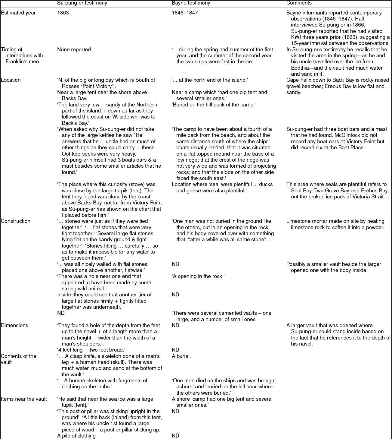
The testimony recorded by Bayne is equally perplexing regarding the location of the vault (Table 1). Bayne identified the site of a burial/vault near a Franklin shore camp, ‘about a fourth of a mile back from the beach, and about the same distance south of where the ships' boats usually landed; that it was situated on a flat topped mound near the base of a low ridge; that the crest of the ridge was not very wide and was formed of projecting rocks; and that the slope on the other side faced the south east’. None of these details specifically describe or exclude the area surrounding Victory Point or the area commonly known as Crozier's landing. Unfortunately, other detailed examinations of the area have all failed to find a vault-like structure in this vicinity (Burwash, Reference Burwash1931; Gilder, Reference Gilder1881; Gross, Reference Gross2006, Reference Gross2012; Klutschak & Barr, Reference Klutschak and Barr1987; McClintock, Reference McClintock1860; Potter, Reference Potter2016; Schwatka, Reference Schwatka1899; Woodman, Reference Woodman1995a). There is evidence, however, of several shore-based tent camps at Cape Felix, Crozier's landing, Erebus Bay and Terror Bay, and it is possible that other tenting sites existed. Yet, to be consistent with the Bayne testimony, the location of the tent camps must have been in areas of abundant wildlife as ‘seal were plentiful the first year, and sometimes the white men went with the natives and shot seal with their guns; that ducks and geese were also plentiful, and the white men shot many’. This description would seemingly exclude the area surrounding Cape Felix and Crozier's landing due to lack of game. The final clues in the Bayne story report to a ‘flat topped mound’ and a ridge crest formed of ‘projecting rocks’. These are also probably very significant clues, but to date have not yielded information specific enough to provide a given location.
The Bayne testimony also has additional clues as to where the events may have taken place. One view has been that the testimony cannot be accurate as there would be no place for ship boats to land upon the shore near Crozier's landing or Cape Felix due to the heavy ice in Victoria Strait. It is true that the pack-ice of Victoria Strait would prevent landing ships’ boats from Cape Felix down to Cape Jane, yet Collinson Inlet, Seal Bay and Erebus Bay are all open during the summer for landing, and would require the use of the ships’ boats to land on shore.
It is of great interest that during Schwatka's 1879 summer examination of the northwest coast of KWI, a grave (although not a vault structure) was found near the vicinity of Crozier's landing (Gilder, Reference Gilder1881; Klutschak & Barr, Reference Klutschak and Barr1987; Schwatka, Reference Schwatka1899). The skeleton was dressed in the clothing of an officer, and the finding of Lieutenant John Irving's Second Mathematical Prize from the Royal Naval College at the grave suggested that the skeleton was John Irving's. Schwatka and his party transported what they believed to be Irving's skeletal remains to the USA from where they were returned to Scotland for a full military burial with honours although the identity is far from conclusive. Critically, the question of whether this structure was the same grave/vault reported by Su-pung-er and the Bayne's witnesses is unresolved. Woodman believes it unlikely, as the observations recorded by Bayne are those of a contemporary witness to the internment of a body. Moreover, Woodman believes that it was not until after McClintock's 1859 exploration of the Erebus Bay area that the Inuit visited the northwestern coast of KWI (Woodman, Reference Woodman2010). Therefore, it was highly unlikely that ‘Irving's grave’ was that described by either Su-pung-er or by the Inuit that Bayne encountered. Perhaps most critically, in both of these cases the vault structure was described as being built below ground, whereas Irving's grave is a shallow structure at grade as described by Klutshak & Barr and Schwatka in their accounts of the grave site (Klutschak & Barr, Reference Klutschak and Barr1987; Schwatka, Reference Schwatka1899).
Conjecture on the timeline of events
Another significant point in the Bayne testimony relates to the timeline of interactions. In the Victory Point cairn note, Franklin's death was given as 11 June 1847. The Bayne informants reported they saw the Franklin men and ships in ‘the spring and summer of the first year and the summer of the next’. It is known that the ships wintered at Beechey Island in 1845–1846. Later, melting ice conditions permitted the ships to sail to KWI, probably in the summer of 1846, where by 12 September 1846 the ships were beset again in the pack-ice preventing further progress. What is not known is the course the ships took between the time they left Beechey Island and when they were beset in ice.
Speculating on this testimony it is conceivable that the ships were in a different location for the majority of the summer of 1846 when the Inuit encountered the expedition in the ‘summer of the first year’. Later, during the ‘summer of the next’ year, the Inuit could have been in position to witness the burial of Franklin or a high-ranking officer. Specifically, if the ships sailed further south into Erebus Bay than previously thought in 1846, then the first encounter with the Inuit could have occurred in August or September at a location where there is ample evidence of Inuit hunting activities, and recent ice charts demonstrate that by late July and early August ice conditions permit sailing into the bay (Canadian Ice Service, 2016). If that were the case, the Inuit could have then returned to their winter hunting grounds in the autumn of 1846 and if the ships wintered over further north they could have been in a position where the Inuit could have visited them in the ‘spring of and summer of the second year’ (1847). This timeline and scenario works for a Franklin burial and a summer camp further afield than what has been assumed based upon the Victory Point cairn note, for the crew would then have been aware of resources and native contacts in the Erebus Bay area, since the testimony also states that the Inuit hunted seals on the ice with the Franklin crew.
Critically, the Bayne testimony recorded that
One man died on the ships and was brought ashore and buried on the hill near where the others were buried; that this man was not buried in the ground like the others, but in an opening in the rock, and his body covered over with something that, ‘after a while was all same stone’.
This observation was probably made shortly after the ‘burial’ perhaps in June/July of 1847, if it describes the burial of Franklin. Bayne's opening in the rock correlates with a doorway which must have originally been sealed from the weather. Su-pung-er and his uncle probably visited the site some 16 years after the events observed by Bayne's informants. Su-pung-er's description suggests that the structure was probably flat upon the ground, the covering was difficult to move by two men, but then after lifting enough of the stones, a hole the depth of a man's navel was observed and the site was ‘nicely walled’ with stone.
Contemplation on the construction of the site
At Hall's request, Su-pung-er drew the structure he saw on KWI (Fig. 3):
Su-pung-er has on this page at my desire just been marking out with my pen the vault covered with stone. It is a very [unclear] made draft. As Nuk-er-zhoo (who entered in at the time Su-pung-er was making it) placed his finger on this plan before the ink had dried [unclear] defacing it I will have Su-pung-er make another & then proceed to describe it.
Apparently, Hall never did get Su-pung-er to revisit his drawing. Given that this was probably Su-pung-er's first attempt at drawing with pen and ink, the drawing is remarkable as it represents a structure with walls and what appears to be a doorway. Moreover, while the drawing is simple, it projects a three-dimensional representation of what was probably underneath the large flat covering stones on the ground, like a contemporary burial vault.
If we speculate on how the vault site could have been constructed based up Su-pung-er's testimony and drawing, and details provided by the Bayne informants, it may be possible to reconstruct what the site may have looked like. Hall requested that Su-pung-er mark out the ‘size of the spot covered by these flat stones, he at once did as I desired & the spot marked was some 4 feet long + two feet broad’ on Friday 4 May 1866. On 4 June 1866 Hall records that Su-pung-er stated that he and his uncle ‘found a hole of the depth from the feet up to the navel + of a length more than a man's height + wider than the width of a man's shoulders + this was all nicely walled with flat stones placed one above another, flatwise’. We estimate that for a five foot tall man, the depth would have been approximately three feet deep. Therefore, to accommodate the foundations, an excavation of at least 100–200 cubic feet of gravel would have been required. Footing stones, or possibly a stone slab, could have been placed as a base to support the wall construction (that is, ‘nicely walled with flat stones’). To be structurally sound, the covering stones would have been required to span the width of the vault and would probably have needed to be about six inches thick. The use of more than one of these large stones would have been very likely. The Bayne story fits here as part of the structure would still have had to have been open for a body to be placed into it, then closed and then made water tight for which it was designed (Table 1).
The Bayne informants described witnessing the burial of a man who ‘was not buried in the ground like the others, but in an opening in the rock, and his body covered over with something that, after a while was all same stone’. Su-pung-er informed Hall that ‘what attracted their [Su-pung-er and his uncle's] attention the most on arriving at this pillar was a stone - or rather several large flat stones lying flat on the sandy ground & tight to-gether [sic].’ Kilmer wrote: ‘. . .we learned that one native had seen some kind of a vault or hole in the ground covered up with large stones and quote unquote “tied” together - that is the expression the native used when he told the story and presumed it mean that the stones are cemented.’
A graphic representation of what the authors hypothesise the site might have looked like at the time of its construction is presented in Fig. 4a. Once the watertight seal was broken (due to freeze–thaw cycles or animal/human activity), water would probably find its way into the vault and gradually destroy the supporting walls (Fig. 4b). Su-pung-er did mention that there was a lot of water inside that he thought might have entered through a hole at one end that appeared to have been made by an animal. We believe that when Su-pung-er looked down into the site he saw a cavity which resembles the drawing he made for Hall (Fig. 4b).

Fig 4. a. An illustrated representation of what the vault might have looked like at the time of its construction. b. Water probably gradually destroyed the supporting walls. c. A representation of what the pillar observed by Su-pung-er might have looked like.
Speculation on the construction of the wooden pillar
Su-pung-er's description of a pillar is unusual:
The part in the ground was square. Next to the ground was a big ball + above this to within a foot or so of the top the stick was round.
Woodman speculates that the pillar may have been a pointing hand sign indicating direction, similar to that found on Beechey Island (Woodman, Reference Woodman1995a). However, the basis for this speculation neither accounts for the pillar being as deeply set into the ground as it was on KWI, nor is there any discussion of the structure having a directional significance. What was described was that the top portion of the pillar was broken off and was lying beside the still erect part which was firmly fixed into the ground. The standing piece was about four feet in height while the top portion was about two feet in length. Therefore, the pillar would probably have stood about six feet high. Su-pung-er and his uncle both thought that it must have been broken off by a polar bear, as they assumed that great strength would have been required to break off such a piece of wood at that height. A reconstruction of the pillar is most instructive. The force of leverage would not allow for the top portion of the pillar to break off—this action would only allow the pillar to pull out or snap at its base. Therefore, the pillar was probably weakened at the point where it was broken. This suggests that the pillar was probably a large wooden cross with the weakness being where the cross member was jointed to the main part of the shaft (Fig. 4c). The cross member was probably four or six feet in length. It is most fitting that a cross would have been used as a grave marker and a signpost given the structures low profile and a featureless terrain.
From Su-pung-er's description, we may speculate further as to the pillars construction. The part that was in the ground was square and was ‘deeply set’. For our reconstruction, we will assume it was at least two feet above the ground to have attracted the Inuit's attention from a distance. Next to the ground was a large ball structure, and then the pillar itself was round up to about a foot from the top where it became square again. The top portion measured about two feet in length, and Su-pung-er concluded that it was broken off. From these details, we again speculate that the structure was a cross: where a notched joint to connect the two pieces would create the weak joint where it was easily broken (Fig. 4c). The ball or orb at the base could easily have contributed to the construction of a ‘Victory Cross’ or the ‘Cross Triumphant’, a most fitting symbol to stand beside the grave of an English Knight.
Consideration of the reliability of the reports
It is also important to consider the reliability of the reports. Su-pung-er's reliability as a witness is evident when he provides Hall with accurate details of what he saw at both Felix and Victoria harbours. Su-pung-er, as a child, saw where Ross's Victory had been abandoned and sunk while remaining attached by a cable to the shore. Su-pung-er refers to a piece of canvas covering most of a boat, most probably the Krusenstern, which Sir John Ross had hauled ashore on the north side of the harbour. Finally, the testimony describes a large round and heavy object that could not be cut in to smaller pieces by the Inuit. Indeed, an object resembling a large iron gear that was part of the Victory’s steam engine dismantled by Ross and left on the shore in Felix Harbour (Fig. 5) was probably what Su-pung-er described as having ‘a good many pieces of iron inside it’.

Fig. 5. An object resembling a large iron gear that was part of the Victory’s steam engine dismantled by Ross and left on the shore in Felix Harbour. This was probably what Su-pung-er described as having ‘a good many pieces of iron inside it’.
While it is noteworthy that Su-pung-er was able to accurately report many observations critical to our understanding of the vaults, other aspects of his personality have led Franklin scholars to question his credibility. For example, Hall reported that Su-pung-er was careless. For example, we learn that Hall lends Su-pung-er a firearm which Hall later has to repair due to Su-pung-er's carelessness (Hall, Reference Hall1866h), and at a different time Su-pung-er accidently discharges the firearm into the face of his son (Hall, Reference Hall1866h). Hall's friend and confidant Captain C.B. Kilmer describes Su-pung-er in a letter as, ‘[t]he native who told the story, is a rather hard customer and I have but little faith in anything he says’ (Kilmer, Reference Kilmer1868). Further, by Western standards, Su-pung-er's behaviour was not above reproach. It was learned that Su-pung-er was engaged in a blood-feud with Neit-e-lik Inuit (Hall, Reference Hall1866f), he stated that a firearm would be desirable to ‘kill other Inuits’ (Hall, Reference Hall1866h). Perhaps most surprisingly, Hall's notes recount that Su-pung-er assisted in killing his aged grandfather (Hall, Reference Hall1866f).
Likewise, the authenticity of the Bayne testimony has also been questioned as it was originally offered for sale to the Canadian Government by George Jamme and T.W. Jackson on Bayne's death. Yet Bayne must have been convinced of the authenticity of his informants testimony because in 1913 he purchased the schooner Duxbury with the intent to sail it to KWI to search for the ‘Franklin vault’ (Morning Oregonian, 1913; Scientific American, 1913). While it remains unclear whether Bayne set out for KWI in 1913, by 1916 he had married and reported that he and his new bride would honeymoon in the Arctic searching for the Franklin tomb (Harrisburg Telegraph, 1916). In 1930 a newspaper report suggested that two men, George Jamme and T.W. ‘Judge’ Jackson, had befriended Bayne before his death, and had learned the location of the vault and intended to seek its location (Evening Post, 1930). Regardless of the authenticity of these testimonies, there can be little doubt that Su-pung-er and Bayne's informants were familiar with what happened to the men of the Franklin expedition.
Conclusions
It is difficult to determine if the observations reported by Su-pung-er and the reports attributed to Inuit encountered by Bayne describe the same feature. In both cases, the vault was described as having been constructed of neatly fitting stone and of a material which tied them together. In both instances, a body or skeleton was found in and around the structure (Table 1). However, there could be more than one site of a stone vault—as a site constructed for one important officer would probably have been replicated to secure the body of another important officer. The timing of the Bayne testimony is ideal if Franklin died on 11 June 1847 where construction of the vault could easily have been completed in warm weather. Neither set of witnesses specifically note whether the site(s) contained any documents. The location of the site(s) described remains enigmatic. The Bayne report includes a map which is noted to be at Victory Point, although Burwash, Woodman and others have specifically examined the area for a stone vault (Table 1). One thing is for certain, there is a high likelihood that there is some truth in both of the separate stories; both accounts describe something that was unusual to the Inuit within the same general area, had been heavily constructed from stone and was designed to protect objects of great importance.
Acknowledgements
The authors thank their families and friends for enduring endless hours of banter regarding the Franklin expedition and the Northwest Passage. We thank Dr H.M. Pinksy (University of Michigan School of Dentistry, MI, USA), Dr L. Susan Taichman (Ann Arbor, MI, USA), Susan Taichman-Robins (Philadelphia, PA, USA), and the members of the Taichman Laboratory and the Office of Research for their helpful discussions (University of Michigan School of Dentistry, MI, USA). The authors also thank David C. Woodman (Vancouver, BC, Canada) for his inspiration, Mr Joe Hursey and staff, Charles Francis Hall Collection, Archives Center, National Museum of American History, Smithsonian Institution and Dr James Savelle, McGill University Department of Anthropology for the image of a gear from the John Ross’ Victory found in Felix Harbour. R.S. Taichman receives support as the Major M. Ash Collegiate Professor of Dentistry.


