INTRODUCTION
Models of the economy of Roman Italy generally focus on supra-regional exchange (Woolf, Reference Woolf1992; Panella and Tchernia, Reference Panella, Tchernia, Scheidel and von Reden2002) and have a strong bias towards urban centres (for example: Jongman, Reference Jongman1988; Morley, Reference Morley1996). In such models, the ‘consumer city’ model in particular, the rural economy is perceived primarily as an agricultural one, with the fulfilling of urban demands as its principal focus (Finley, Reference Finley1973; Parkins, Reference Parkins1997; Erdkamp, Reference Erdkamp2001). However, Roman economic networks were undoubtedly more complex. For example, ethnographic and historical comparative studies suggest that rural economies in complex pre-industrial societies were not based primarily on relationships between rural sites and urban centres, but that much production and exchange took place within and between rural areas (Smith, Reference Smith1974). Also, economic geographical theories, such as Central Place Theory, suggest that in areas that lie beyond daily commuting distance from urban centres, lesser sites must have performed central-place functions (Bekker-Nielsen, Reference Bekker-Nielsen1989). Finally, considering the importance of inland transport, various trade-related services and industries may have developed in favourable locations on roads and rivers (Laurence, Reference Laurence1999). Rural agglomerations, in this contribution for convenience sake referred to as ‘minor centres’, thus may have served various roles in the Roman economy: they may have been the focus of daily life for many rural communities, whilst potentially functioning as important nodes in trade networks as well.
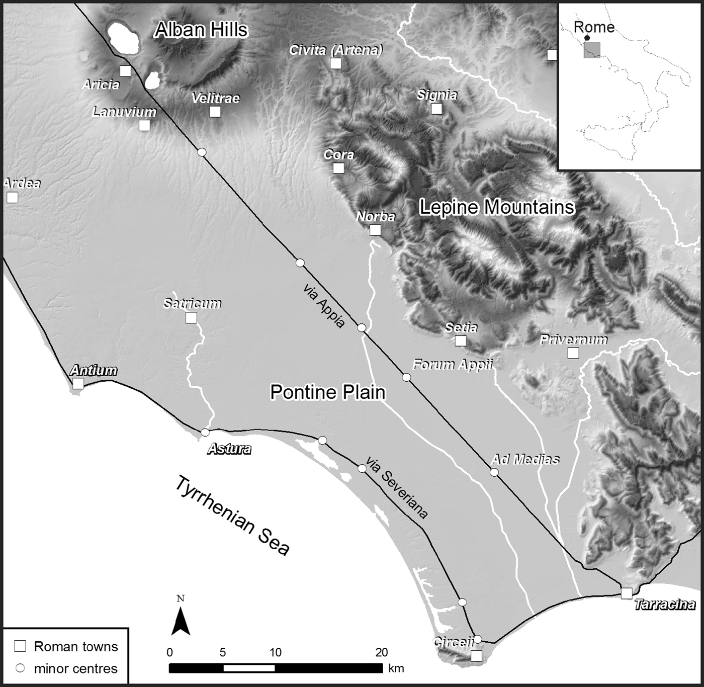
This article reviews the first outcomes of a project that focuses attention on minor centres, and their economic functions. After a discussion of the issues of definition and existing scholarship on such sites, we first approach their potential functions through geographic models. We then move on to discuss the results of a programme of geophysical surveys and field walking at two case-study sites, Forum Appii and Ad Medias, situated in the Pontine plain (Lazio, central Italy) along the Via Appia, evaluating their differing roles within local and regional economic systems. We shall conclude with a discussion of the implications for future research.
MINOR CENTRES: ISSUES OF DEFINITION AND THE STATE OF RESEARCH
Written, cartographic and archaeological sources suggest that many nucleated sites existed in the Roman period besides ‘urban’ centres and isolated ‘rural’ sites such as farms and villas. Besides ‘urban’ categories such as municipium and colonia, written sources refer to many such sites, including canabae, vicus, conciliabulum and forum (Ruoff-Väänen, Reference Ruoff-Väänen1978: 4–10; Tarpin, Reference Tarpin1999: 4–6). In some cases, these labels have specific connotations, but at the same time the exact meaning of and differences between these categories are not well-defined. A forum, for example, implies the presence of a market-place, and a sanctuary and certain administrative functions are thought to be associated with such sites as well. On the other hand, a conciliabulum is simply ‘a place where people meet’, without any clear connection to the size, functions or associated buildings that it is supposed to encompass (Tarpin, Reference Tarpin1999: 4; Todisco, Reference Todisco2011: part 1). In addition, we know of different types of settlements related to travelling, such as mansiones, stationes and mutationes. These terms indicate specific functions as stop-overs and places where animals can be changed, and therefore imply the presence of specific structures (inns, stables). Possibly they also had administrative functions associated with the cursus publicus (Corsi, Reference Corsi2000: 23–43).
Needless to say the direct application of these labels to archaeologically detected sites is problematic. At the same time, archaeological research suggests that minor centres were quite common. Not only may we include here settlements variously referred to as Kleinstädte, Quasi-Städte, small towns, local centres, villages, rural centres, secondary centres and agglomérations secondaires (Brüggler, Reference Brüggler, Hirschel and Ludowici2010: 16); we may think also of hill-forts, monasteries and sanctuaries, mining villages, prisons and work camps (Bekker-Nielsen, Reference Bekker-Nielsen1989: 4).
While nucleated non-urban settlements are particularly abundant in the less urbanized northwestern provinces of the Roman Empire (cf. Bekker-Nielsen, Reference Bekker-Nielsen1989),Footnote 1 these different sorts of intermediate sites occur in all parts of the empire (cf. Leveau, Reference Leveau1993: 469–71; Corsi, Reference Corsi2000: 78–82). In the northwestern provinces (Gaul, Britain), minor centres are well-studied and commonly referred to as vici. This label hides considerable variation in terms of size, layout, location and functions. In Gaul, for example, they range from large sites (up to 100 ha) with all the features that are commonly considered urban (street-grids, public buildings, a forum, and so on) to small, non-urban sites (Rorison, Reference Rorison2001: 3–15). They also vary considerably in terms of location, and may be associated with roads, rivers, military camps or temples (Brüggler, Reference Brüggler, Hirschel and Ludowici2010: 16–17). An important aspect that these sites share is their commercial functions. Ceramic production, metalworking and other crafts are commonly associated with vici. Many also include shops and market facilities, pointing towards their function as market-places. Finally, some also comprise ports and/or warehouses, features suggestive of redistributive functions, and in Britain some of these sites are associated with mining (Sommer, Reference Sommer1984: 34–6; Rorison, Reference Rorison2001: 51–5).
While minor centres have received less attention in Italy than in the provinces, survey projects do commonly map larger scatters (several hectares) sometimes labelled as statio, vicus or mansio, but more often described by more neutral terms such as hamlets, villages, nucleated settlements, aggregato or abitato.Footnote 2 Considering the many methodological issues involved in interpreting surface data, such interpretations are of course highly tentative. However, more detailed knowledge of these types of sites has been acquired over recent decades through detailed topographic research and excavations. Cristina Corsi summarized research on road stations, which commonly appear to be associated with productive structures (Corsi, Reference Corsi2000: 180). For southern Italy, we have at our disposal systematic inventories of hill-forts (Oakley, Reference Oakley1995), vici and other minor centres (Volpe and Turchiano, Reference Volpe and Turchiano2005; Todisco, Reference Todisco2011). In northern Italy minor centres also occur frequently, particularly in upland areas (Santoro, Reference Santoro2007). Work on such sites in central Italy includes geophysical mapping at road stations and small towns in the Tiber valley within the framework of the ‘Roman Towns Project’ (Johnson, Keay and Millett, Reference Johnson, Keay and Millett2004; Hay et al., Reference Hay, Johnson, Keay and Millett2010).
Several minor centres have been investigated in more detail, through extensive excavations. The site of Vagnari in modern Apulia originated in the second and first centuries bc and grew into a sizeable village (vicus) in the first century ad, after which it was substantially reorganized during the late first/second century ad. The settlement, which is assumed to have been part of a large imperial estate, was involved in sheep/goat and pig raising, but also had various industrial production facilities (tile production, iron-working) and a bakery (Small, Reference Small2011: 25–8). Another excavated example is the site of Mola di Monte Gelato in southern Etruria. It originated as a wealthy villa complex, but in late Roman times (and after a period of abandonment) probably became a larger settlement with an associated church. Besides including facilities for metalworking (bronze-casting, iron-working) and the production of lime, this settlement yielded some evidence for glass production, carpentry, bone carving, and the production of wool and hides. Although the excavators were cautious in interpreting the site, they suggested this village-like complex was part of a large élite estate or, perhaps more likely, an ecclesiastical complex (Potter and King, Reference Potter and King1997: 423–4).Footnote 3 With its various productive features and its church, the site would have provided various central-place functions for its surroundings.
MINOR CENTRES AND THEIR FUNCTION: GEOGRAPHIC APPROACHES
Historical and archaeological sources thus demonstrate the common occurrence of minor centres, both in the Roman provinces and in Italy. They also show that it is difficult to relate such sites to historical categories, unless there is a direct link with historical sources. More importantly, archaeological evidence suggests that the term ‘minor centre’ may hide a wide variety of site types that, at least partly, overlap with what we commonly define as ‘rural’ sites (that is large villa estates) or ‘urban’ centres.Footnote 4
In the light of recent discussions on urbanization, which tend to diverge from traditional normative notions of urbanism, these overlaps should not be considered problematic. In reality, we may expect a continuum of sites of different sizes, and merely labelling these does not help us to understand their functions (Millett, Reference Millett and Brown1995: 29; Horden and Purcell, Reference Horden and Purcell2000: 92–6; Smith, Reference Smith, Osborne and Cunliffe2005: 108). It is rather the social, political and economic potential that a site with a relatively dense and large population offers that makes it an important object of study (Osborne, Reference Osborne, Osborne and Cunliffe2005: 13).
By focusing on the functions of sites and not on their normative classification, Central Place Theory offers one useful perspective to study the economic roles of minor centres (Bekker-Nielsen, Reference Bekker-Nielsen1989). While acknowledging the limitations in its application to archaeological sources, the principles underlying Central Place Theory are in our view a valid starting-point to explore the economic dimensions of sites (cf. De Haas et al., forthcoming). Central Place Theory would suggest that in areas that lie beyond daily commuting distance from urban centres, other sites must have performed central-place functions, for example as market-places, centres of craft production, places of worship or as administrative foci (cf. Whittaker, Reference Whittaker1990). This would have been particularly common in the Roman provinces and in the northern and southern parts of Italy, where urban densities were considerably lower than in central Italy. On the other hand, such centres may have fulfilled an equally important role in this more urbanized area, where high population levels may have warranted the rise of lower-order centres at shorter distances from towns, providing goods and services to the rural population (Dicken and Lloyd, Reference Dicken and Lloyd1990: 19–25).
While Central Place Theory offers a principally static perspective on the economic roles of sites, Network Analysis provides a second, more dynamic perspective. It allows consideration of their roles not only in relation to other sites, but also in terms of connectivity. While connectivity may be conceived in many ways (social, political), we point especially to the importance of geographic connectivity as provided by roads and waterways. Minor centres with favourable positions in such infrastructural networks (road stations) may have gained importance not only as local central places, but also as nodes in wider trade networks (Jenkins, Reference Jenkins2001; cf. De Haas et al., forthcoming). It is on two of such road stations that we focus in the remainder of this paper.
THE MINOR CENTRES PROJECT: BACKGROUND, AIMS AND APPROACHES
The project ‘Fora, stationes, and sanctuaries: the role of minor centres in the economy of Roman central Italy’ (henceforth the Minor Centres Project) is carried out by the Groningen Institute of Archaeology (GIA) of the University of Groningen.Footnote 5 It was initiated in 2011 and aims to understand better the nature and central-place functions of minor centres in Roman central Italy. To achieve this, the project uses both a top-down and a bottom-up approach. The top-down approach entails a study of the economic geography of central Italy, looking at settlement patterns and infrastructure in relation to agricultural and non-agricultural economic activities. Changes in such patterns are studied using geographical models such as Central Place Theory and Network Analysis, leading to hypotheses regarding the different functions of minor centres within the economy of central Italy (De Haas et al., forthcoming). These hypotheses are subsequently tested by reviewing the archaeological evidence from central Italian minor centres.
This paper focuses on the second, bottom-up, approach that entails field and desktop studies of minor centres in the Pontine region south of Rome (Lazio, central Italy) (Fig. 1), forming a new phase in the GIA's Pontine Region Project (Attema, Reference Attema1993; Attema, Burgers and van Leusen, Reference Attema, Burgers and Van Leusen2010; Attema, de Haas and Tol, Reference Attema, de Haas and Tol2011; De Haas, Reference Attema, de Haas and Tol2011; Tol, Reference Tol2012). Two of the sites studied are Ad Medias and Forum Appii, both road stations along the Via Appia. These sites are situated in the Pontine plain, an infamous wetland that was reclaimed and opened up with the construction of the Via Appia in the late fourth century bc (Hoffman, Reference Hoffman1956; De Haas, Reference Attema, de Haas and Tol2011: chapter 8). Our research aims to elucidate the function of these road stations in both their local rural settlement context and within regional trade networks, and to assess variations in size and function within the generic class of minor centres.

Fig. 1. The Pontine region with the main sites, roads and rivers. (Tymon de Haas/RUG/GIA.)
The project uses an integrated non-invasive approach, common in the study of urban sites (for example: Vermeulen et al., Reference Vermeulen, Burgers, Keay and Corsi2012): a (GIS-based) desktop study of topographic and cartographic sources is combined with geophysical survey and systematic field walking. Together, these methods allow us to reconstruct the layout and central-place functions of these minor centres, as well as their development over time.
For our case-studies, we have two cartographic sources at our disposal. Firstly, the 1:5,000 maps made by the Istituto Geografico Militare for the Consorzio della Bonificazione Pontina in the 1920s contain a wealth of information on the landscape prior to the large-scale reclamations of the Fascist regime of the 1930s. Secondly, a set of aerial photographs taken in 1955 holds information on many sites and cadastral traces in the Pontine plain that since then have been lost due to the destructive effects of modern agriculture. Additional information on the archaeology and topography of the sites under study may be drawn from a number of previous archaeological studies, which are discussed below.
The geophysical surveys were carried out using magnetic gradiometry,Footnote 6 and aimed to identify and interpret buried structural remains at both sites. The chosen technique is particularly suited to detect features associated with economic functions such as local artisanal production (for example kilns) and trade-related facilities (for example warehouses and infrastructural remains). Such features typically include materials fired at high temperatures (for example kiln remains, slags and brick-built walls) and should thus be clearly visible in magnetic prospection.Footnote 7
Field walking was carried out using a highly intensive methodology: grid units of 25 × 25 m were walked at 25% coverage, with each walker picking up all artefacts encountered in their respective lanes. After initial walking each unit was inspected again at 100% coverage in order to collect a supplementary diagnostic sample. Although resulting in the collection (and subsequent processing) of large amounts of material, recent experimental work shows that such an intensive sampling approach is necessary to answer detailed questions regarding infra-site functional zoning and chronological development (Tol, Reference Tol2012: chapters 3 and 5). In addition, large pottery samples provide a solid foundation from which to approach the position of the studied sites within trade networks (De Haas and Tol, forthcoming). The grid size was chosen in order to relate surface distributions accurately to any anomalies showing up in the geophysical surveys.Footnote 8
CASE 1: THE SITE OF FORUM APPII
The first case we discuss is the site of Forum Appii (present-day Borgo Faiti, in the province of Latina) (Fig. 1). It is situated on the 43rd mile of the Via Appia, at the confluence of the Cavata and the Decennovium canal that for 19 miles runs parallel to the Via Appia before discharging into the Tyrrhenian sea at Tarracina. Both waterways are thought to have been navigable in antiquity.Footnote 9 The status of the site as a forum (and from the first century bc onwards presumably as a municipium)Footnote 10 suggests that it functioned as a local market and administrative centre (Ruoff-Väänen, Reference Ruoff-Väänen1978: 6–10). In cartographic sources, the site is indicated as a mutatio or mansio, and it therefore served as a stop-over in the cursus publicus (Bruckner, Reference Bruckner1995: 198; Corsi, Reference Corsi2000: 85).
PREVIOUS RESEARCH AND CARTOGRAPHY
Previous studies of the site provide important insights into its layout and functions (Fig. 2A). An early eighteenth-century drawing documents the presence of two large adjacent structures, one perhaps to be interpreted as a monumental tomb (the so-called Arco della Comunità), the other possibly as the remains of a small bathing complex (a balneum), neither of which are visible today (Corradini, Reference Corradini1705). Based on a study of aerial photographs and topographic surveys, Elisabeth Christiane Bruckner identified various Roman remains, including a large building interpreted as the mansio, two byways forking off the Appia, and an embankment wall on the north side of the Decennovium canal, which may relate to a river port (Bruckner, Reference Bruckner1995).Footnote 11 The presence of one or more cult places at the site is clear from the presence of anatomical votives and a dedicatory inscription (CIL X 6482).Footnote 12 Two funerary inscriptions, a tile-covered grave found during agricultural works as well as a travertine block with the depiction of an urceus, are evidence for the presence of graves (Nicolay, Reference Nicolay1800; Bruckner, Reference Bruckner1995: 216). Bruckner suggested that the site covered at least 5 ha, and that it constituted an important reference-point for the surrounding rural population between the late fourth century bc and the late fifth–early sixth centuries ad (Bruckner, Reference Bruckner1995: 199).
Fig. 2. (A) Map of Forum Appii, showing the studied area and previously mapped features. (B) 1:5,000 map of Forum Appii with indication of the features discussed in the text. (Tymon de Haas, RUG/GIA.)
Unfortunately, the aerial photographs that cover the site of Forum Appii have a low resolution, making them of limited use in identifying archaeological remains. Important information on the site's topography is, however, provided by the 1:5,000 maps (Fig. 2B). They show many slight elevations in the terrain along the Cavata and Decennovium/Via Appia, which (as is confirmed by the field walking and geophysical survey; see below) reflect the presence of buried ancient remains.Footnote 13 They thereby presumably indicate the main built-up area of the site. In addition, several rectangular structures are visible, both to the north and south of the Via Appia (circles in Fig. 2B). As these do not correspond to contemporary buildings, they probably reflect ancient structural remains (this seems to be corroborated by geophysical survey and field walking) that in the early twentieth century were still visible on the surface. The map also shows two conspicuous bulges in the Decennovium canal (grey arrows in Fig. 2B). Although it is difficult to say whether these are ancient, they might reflect the location of ancient mooring places. Finally, the map shows a curvilinear gully that bounds the site to the northeast (black arrows in Fig. 2B).Footnote 14
GEOPHYSICAL SURVEY
The geophysical survey targeted two different parts of the site (Fig. 2A, areas 1 and 4). The first is located northwest of the confluence of the Cavata and the Decennovium canal. The data from this area are rather noisy, which may be explained by the high density of fired ceramics in the topsoil (Fig. 3). However, structural remains were mapped that probably date to the Roman period.Footnote 15 The latter include a possible series of four kilns, flanked by a small almost square structure, with a possible fifth kiln situated c. 65 m to the north. A number of anomalies, situated along the Via Appia probably represent remains of buildings. They may correspond to what Bruckner identified as the mansio, although her proposed reconstruction cannot be confirmed. Most of these anomalies provide only slight responses, suggesting that they represent the most deeply buried foundations of buildings that otherwise have been erased by intensive agriculture. The strength of the response suggests the employment of high-fired (for example brick) building materials, which would imply a date in the Imperial period.Footnote 16 Such a date is corroborated by the finds from field walking, which was predominantly early to late Imperial pottery and building materials. Finally, two discrete positive anomalies probably relate to rubbish pits or other cut structures with magnetically enhanced fills.
Fig. 3. Forum Appii. (A) Geophysical data from area 1 (collected with Bartington DualGrad 601). Data have been corrected (spikes removed, striping removed, stagger corrected) and smoothed by interpolation from 0.5×0.125 to 0.25×0.125. (B) Interpretation of the anomalies visible in the geophysical data from area 1. (Kayt Armstrong/Tymon de Haas, RUG/GIA.)
The second area investigated through geophysical survey is located on the other side of the Via Appia, some 400 m to the south of area 1. It lies close to the aforementioned embankment wall on the Decennovium canal (Fig. 2, area 4). In this area two sets of buildings were identified (Fig. 4). The first comprises a number of structures close to and aligned along the canal, two of which provide stronger responses suggestive of either the use of high-fired building materials or broad foundation trenches. One rectangular anomaly measures c. 40 × 5 m, and to its north and east it may be flanked by the remains of another structure. While at present it is difficult to propose an interpretation of these structures, they have dimensions comparable to those of structures that at Portus have been interpreted as warehouses (Keay et al., Reference Keay, Millett, Paroli and Strutt2005: 97, 105). Approximately 20 m to the southeast there is a second large structure of c. 25 × 20 m that still must have been standing above ground in the early twentieth-century, as it appears on the 1:5,000 map (Fig. 2B). The geophysical anomaly is wide and its signal is strong, again suggesting a substantial wall footing and perhaps the use of high-fired building materials (bricks). Again, parallels may be found in the geophysical data from Portus (Keay et al., Reference Keay, Millett, Paroli and Strutt2005: 101, anomalies 8.4 and 8.14). Although systematic field walking could not be carried out in this area, grab samples collected during the geophysical survey yielded predominantly early and mid-Imperial pottery, including Italian terra sigillata and early African red slip ware.
Fig. 4. Forum Appii. (A) Geophysical data from area 4 (collected with 2×FM256 on frame, 1 m separation). Data have been corrected (selective de-striping to preserve anomalies running parallel to traverse), and smoothed by interpolation from 0.5×0.125 to 0.25×0.25. (B) Interpretation of the anomalies visible in the geophysical data from area 4. (Kayt Armstrong/Tymon de Haas, RUG/GIA.)
A second group of structures, of variable orientation, shows up with much less strong magnetic signals, suggesting that these are either buried more deeply, or constructed using different materials, such as stone. Unfortunately we have no artefact samples related to these anomalies, and it therefore is unclear whether they represent a different phase from the first group of buildings. The recorded structures include at least three large and two smaller rectangular ones. To the southeast, the presence of a small industrial zone is hypothesized based on the strength and morphology of the magnetic signal. This interpretation is corroborated by the presence of metal slag on the surface, suggestive of metalworking.
FIELD WALKING
Field walking was conducted at Forum Appii in three areas, all to the north of the Via Appia (Fig. 2A, areas 1–3). In all of these large quantities of ancient materials were observed, in density by far superseding those recorded at Ad Medias (see below) (Fig. 5). The areas with high densities correspond to the elevations as visible on the 1:5,000 map, substantiating the suggestion that these higher areas reflect ancient structures buried under the surface (see also Fig. 2B).
Fig. 5. Forum Appii, fields 1–3. (A) overall artefact densities (no. per hectare, corrected for coverage and visibility). (B) Proportion of amphorae per unit. (C) Number of black-gloss ware, terra sigillata and African red slip ware fragments per unit. (Tymon de Haas, RUG/GIA.)
The field walking corroborated the site's chronology as already proposed by Bruckner (Reference Bruckner1995: 215–16). The earliest evidence for occupation consists of black-gloss ware fragments, including stamped examples of the gruppo dei piccoli stampigli, dating to the late fourth or early third century bc (Morel, Reference Morel1981; Stanco, Reference Stanco, Jolivet, Pavolini, Tomei and Volpe2009). The most recent pottery collected (forms in ARS D; Hayes, Reference Hayes1972; Bonifay, Reference Bonifay2004) dates to the late fifth or early sixth century ad. The artefacts include large numbers of and a wide variability in imported ceramics, amphorae in particular. As can be seen in Table 1, many more types have been found at Forum Appii than at the nearby minor centre of Ad Medias, or at equally intensively sampled isolated rural sites that are presumably typical ‘consumption sites’.Footnote 17 This suggests that the site functioned as a centre of (re)distribution of goods and therefore, being situated at a favourable junction of roads and rivers, occupied an important role in the regional trade-network.
Table 1. Amphora types identified at Forum Appii, at Ad Medias and at rural sites in the Pontine plain (site 14003) and the coastal area close to Antium (site 15106).
The ceramic evidence also suggests that the site changed in extent and function over time (Fig. 5B and C). The northernmost area (area 1) yielded large amounts of pottery and building materials that cover the entire chronology of the site. The building remains include many elements of luxury architecture such as painted plaster, marble elements, (decorated) window glass, and stone and glass tesserae. The highest artefact densities are recorded in the northern part of the area. This area shows a high proportion of amphora fragments (Fig. 5B), perhaps suggestive of commercial activities along the Cavata. Republican materials are found mainly in areas where no structural anomalies were observed in the geophysical survey. This could suggest that, to the south, Republican phases are covered by later building activities and therefore are not visible on the surface.
In areas 2 and 3, artefact densities are very high along the Via Appia and decline rapidly moving away from the road. In area 2 mainly Imperial period pottery and building debris were found, and the presence of tombs in this area (as surmised in previous studies) is confirmed by finds of human bone on the surface. Along the edges of area 2 we observed a number of large square limestone blocks pertaining to a large building or perhaps a pavement, and two large millstones (Fig. 6A), suggesting that a bakery was situated in this area. In area 3 the assemblage contained relatively few building materials, and mostly consisted of Republican to early Imperial period ceramics. The low tile:pottery ratio recorded could indicate that this part of the site fell outside the main built-up area of the site, and was abandoned after the early Imperial period.
Fig. 6. Forum Appii. (A) Two millstones from area 2. (B) Tile and cover tile wasters from the pottery cluster in the northern part of area 3. (Tymon de Haas/Gijs Tol, RUG/GIA.)
In the northern part of area 3 (perhaps also covering part of area 2) a separate cluster of pottery was noted. It contained many wasters of tile and cover tile, as well as several clearly misfired coarse-ware and amphora fragments (Figs 5B and 6B). The recorded material dates almost exclusively between the second century bc and the first century ad, and the ceramic workshop that is suggested by the wasters must have operated within this time span.
CASE 2: THE SITE OF AD MEDIAS
Our second case-study, Ad Medias, is situated between the 51st and 52nd mile of the Via Appia, half-way between Forum Appii and Tarracina in the lowest part of the Pontine plain (Fig. 1). The location of the site is partly occupied by the eighteenth-century Casale di Mesa di Pontinia (Fig. 7A). While it is not known from historical sources, Ad Medias is mentioned in a late antique itinerary as a mutatio (Cuntz, Reference Cuntz1929: 101; Corsi, Reference Corsi2000: 85).
Fig. 7. Ad Medias. (A) The studied areas and previously mapped features. (B) 1:5,000 map with indication of the features discussed in the text. (Tymon de Haas, RUG/GIA.)
PREVIOUS RESEARCH AND CARTOGRAPHY
To date, little is known about Ad Medias, although Margherita Cancellieri and Filippo Coarelli have published studies on the site (Cancellieri, Reference Cancellieri1975; Coarelli, Reference Coarelli1998; Coarelli, Reference Coarelli, Harris and Lo Cascio2005). Reportedly, the Casale di Mesa was founded on ancient ruins, and it preserves several inscriptions from the area (Cancellieri, Reference Cancellieri1975). The only surviving monumental structure, a large mausoleum known as the mausoleo di Clesippo, is of late Republican or early Imperial date (Cancellieri, Reference Cancellieri1975; Coarelli, Reference Coarelli1998). However, late eighteenth-century sources suggest that the site originally covered a larger area, with structural remains extending into the marsh (Corradini, Reference Corradini1705: 65). An east–west road intersecting the Via Appia was documented by Lugli in the 1920s (reported by Cancellieri (Reference Cancellieri1987: 45)).
In addition, 300 m southwest of the Casale di Mesa a monumental building measuring approximately 150 × 100 m was identified on aerial photographs (Cancellieri, Reference Cancellieri1987: 68–9) (see also below, Fig. 9D). Its location and orientation are of considerable interest in the light of other finds from the area. According to the archives of the Soprintendenza, seven bronze plaques with dedicatory inscriptions, tentatively dated to the second half of the fourth and/or third centuries bc (Solin, Reference Solin1999: 398–400; Coarelli, Reference Coarelli, Harris and Lo Cascio2005: 185), were found near this structure. Third-century bc votives, including black-gloss pottery and a group of terracotta statuettes, were reportedly found in the area as well (Cancellieri, Reference Cancellieri1975: 18; Maassen, Reference Maassen2006). These finds suggest that a sanctuary existed at or near this large complex.
Another interesting feature of the building is that it is oriented on a north–south/east–west axis, matching the orientation of a centuriation scheme of Roman origin. This scheme used plots of 10 × 10 actus (c. 355 × 355 m) and covered an area of more than 230 km2 between Forum Appii and the 57th mile (Cancellieri, Reference Cancellieri, Bussi and Vandelli1985; Cancellieri, Reference Cancellieri1990; De Haas, Reference de Haas2011: 210–13). The fact that its orientation deviates from that of the Via Appia is seen by some as an indication that it preceded the construction of the road, possibly linked with the establishment of the tribus Oufentina (Cancellieri, Reference Cancellieri, Bussi and Vandelli1985; Coarelli, Reference Coarelli, Harris and Lo Cascio2005: 188–9).Footnote 18 Besides the information from aerial photographs, the 1:5,000 map also shows some interesting features that may pertain to the ancient site of Ad Medias (Fig. 7B). Firstly, a bulge in the Decennovium opposite the Casale di Mesa, could relate to an ancient mooring place (Fig. 7B, grey arrow). In addition, at least one rectangular structure is visible that could be of ancient origin (Fig. 7B, black circle). Finally, although not as clear and extensive as at Forum Appii, the map also shows discrete elevated areas indicated by contour lines to the north of the mausoleum and in the area of the large structure that was clearly visible on the aerial photograph.
GEOPHYSICAL SURVEY
The geophysical survey at Ad Medias targeted areas on either side of the Via Appia (Fig. 8, areas 1–3), revealing scant structural evidence. In area 2, one small rectangular anomaly was recorded west of the mausoleum; it may represent a second but much smaller burial monument. In addition, the survey shows that the mausoleum was flanked to the north by a large structure that, considering the strong response, may have been brick-built. In area 1 on the south side of the Via Appia, one area shows a ‘noisy’ magnetic signal. It corresponds to a small ceramic scatter that was later recorded during field walking adjacent to the bulge in the Decennovium canal (Fig. 8B). A linear anomaly running from this site to the southwest may represent an ancient road.
Fig. 8. Ad Medias. (A) Geophysical data from areas 1–3. Area 1: data collected with Bartington DualGrad 601, corrected (spikes removed, striping removed, stagger corrected in part of the data), and smoothed by interpolation from 0.5×0.125 to 0.25×0.125. Areas 2 and 3: collected at 0.5×approximately 0.1 m resolution using the EasternAtlas DecaGrad cart system, using combined dGPS and odometer location. Smoothed to 0.25×0.25 m final resolution using an in-house kriging routine. (B) Interpretation of anomalies visible in the geophysical data from areas 1–3. (Kayt Armstrong/Tymon de Haas, RUG/GIA.)
In addition, the geophysical survey yielded several north–south and east–west linear anomalies that probably represent ditches and canals. The largest of these, situated in area 2 and some 6.5 m wide, was certainly a canal, as it stands in direct contact with the Decennovium through a tunnel that today still runs under the Via Appia. A series of smaller perpendicular ditches are attached to this canal, while 300 m to the southeast (directly northeast of the Casale di Mesa) there are two similar linear anomalies. The orientation of these anomalies suggests that they were part of the centuriation system, which apparently included massive canalization to drain this low-lying area.Footnote 19
FIELD WALKING
For the area south of the Appia, field-walking data complement the data from the geophysical survey and the study of the 1:5,000 map (Fig. 9).Footnote 20 In this area, two discrete scatters were identified, close to the Decennovium canal, southwest of the Casale di Mesa (indicated by circles in Fig. 9A). The southernmost of these scatters, which contains mainly pottery and building materials, lies next to the bulge in the canal and corresponds to the area where the geophysical survey recorded a noisy signal. The presence of slag may indicate that metal production took place in this area, although no kilns were observed in the geophysical data (Fig. 10A). The collected pottery dates the site between late Republican times and the fourth century ad, whilst the presence of glazed ceramics indicates a post-Roman phase of occupation. The second scatter, situated slightly to the northwest, corresponds to the location of the rectangular structure visible in the 1:5,000 map. It is larger than the first one, and contains tile, pottery and building debris. These materials mostly date to the Republican period (fourth–first centuries bc), although glazed pottery suggests that this area was reoccupied in post-Roman times. The occurrence of fragments of so-called milk strainers, which are associated with the preparation of dairy products, is notable (Fig. 10B).Footnote 21
Fig. 9. Ad Medias. (A) Overall artefact densities (no. per hectare, corrected for coverage and visibility). (B) Distribution of production debris (iron slag). (C) Number of black-gloss, terra sigillata and African red slip ware fragments per unit. (D) A large building visible in a 1955 aerial photograph. (Tymon de Haas, RUG/GIA.)
Fig. 10. Ad Medias. (A) Slag from the southernmost scatter. (B) Milk strainer fragments from the northernmost scatter. (Gijs Tol, RUG/GIA.)
SUMMARY OF RESULTS, DISCUSSION AND IMPLICATIONS
Although at both Forum Appii and Ad Medias restricted areas were investigated, the results show that both sites performed various central-place functions. At the same time the two sites show clear differences in character, size and chronology. These differences have important implications for our understanding of the variations in central-place functions that these minor centres had.
The available evidence suggests that Forum Appii was founded in the late fourth or early third century bc, and that it continued to be inhabited over the following eight centuries. The site fulfilled different central-place functions (Fig. 11A). In its earliest phase the site already extended over a large area, and during the late Republican period it may have covered at least 12 ha. We can be sure that in the Republican period Forum Appii already housed a sanctuary and ceramic production facilities. In addition, the site housed a bakery, and metalworking also took place (although these functions are difficult to pinpoint chronologically). The availability of these services, together with the market and administrative functions that the site had as a forum, made Forum Appii a central place for the surrounding rural population and an important stop along the Via Appia.
Fig. 11. Proposed reconstruction of (A) Forum Appii and (B) Ad Medias based on current and previous research. (Tymon de Haas, RUG/GIA.)
Besides such functions, which may be considered of primarily local importance, it seems that Forum Appii had, by the early Imperial period, also obtained importance on a regional level. The geophysical prospection has yielded evidence of structures around the confluence of the Cavata and the Decennovium canal. Considering their ground-plans, these structures may have had commercial functions related to a nearby river harbour, the existence of which is hinted at also in historical sources.Footnote 22 The site's role in regional trade is evidenced by the large amounts of and variety in amphorae and other imported goods that were documented during field walking. The site's favourable position in infrastructural networks (at the junction of several roads and riverine routes) would support its importance for transshipment, and therefore as a hub in regional trade networks.
The evidence from Ad Medias suggests that it was not only inhabited over a shorter period (Republican and early Imperial times, with small-scale activities until the fourth century ad), but also that the settlement was much smaller than Forum Appii (Fig. 11B). Even if the centre of the ancient settlement is located underneath the Casale di Mesa and therefore remains unmapped, we can be sure that it did not occupy more than a few hectares. None the less, the site also performed central-place functions, but on a more modest scale: it definitely housed a sanctuary, and metalworking and manufacturing of dairy products also took place. Thus, Ad Medias seems to have been a central place of only local importance.Footnote 23
On a more general level, we note that the results of our research confirm that, as was suggested by Central Place Theory and Network Analysis, minor centres (acknowledging that this label covers a wide variety of sites with a correspondingly wide variety of functions) could indeed become central places providing day-to-day goods and services for the local rural population. When situated along major roads, they could benefit also from the requirement for goods and services created by travellers. In combination, the demand created by the local populations and passers-by could attract a variety of artisan and other activities (either transient or on a permanent basis), thereby contributing to the rise of a non-agricultural component in the rural economy. Moreover, when favourably situated in terms of connectivity (that is, in infrastructural networks), they also could become important nodes in regional trade systems.
Whilst providing important new insights into the (variety of) roles that both the studied sites played, our research has raised new questions, particularly regarding the relationship between minor centres and the surrounding rural population. A subsequent phase of the project therefore will focus specifically on this relationship, again using Forum Appii and Ad Medias as case-studies. This includes field walking in their territories combined with detailed ceramic studies (both typological and petrographic analysis), in order to assess their role in the production and (re)distribution of locally made, as well as imported, pottery (Tol and de Haas, Reference Tol, de Haas and Olcese2013). At the same time these rural surveys will provide us with valuable information on the historical context in which these two sites were established and functioned.Footnote 24
With regard to the top-down approach, we intend to analyse further the regionally available evidence in the light of Central Place Theory and Network Analysis. We will study the distribution of central places (both ‘urban’ and ‘minor’), and the availability of specific goods and services at these centres, in order to understand better the specific functions of individual centres and the complementarity of the regional system of central places. By integrating historical, epigraphic and archaeological data, both from excavations and intensive non-invasive research as presented here, we hope to clarify the role of minor centres such as Forum Appii and Ad Medias within regional economic networks.