
INTRODUCTION
This paper has two main aims. Firstly, it discusses the evidence for the concentration and centralization of late prehistoric settlement in central Italy, using the territory of Nepi as an example of settlement aggregation in southern Etruria. This example and the related agricultural modelling (Rajala, Reference Rajala2002) help to explain the regional developments that led to urbanization and state formation in Etruria from the Bronze Age to the Iron Age. Secondly, it publishes the new concentrations of late prehistoric ceramic material, interpreted as sites, found during the Nepi Survey Project (Fig. 1).
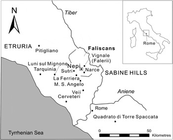
Fig. 1. Central Italy and the location of Nepi. (Illustration: author.)
The Early Iron Age was a moment of drastic change in the prehistoric settlement history of southern Etruria (di Gennaro, Reference di Gennaro1986; di Gennaro and Peroni, Reference di Gennaro and Peroni1986; di Gennaro, Reference di Gennaro, Colonna, Bettini and Staccioli1988). Most small- and medium-sized final bronze age centres disappeared, and the population concentrated onto a few larger plateaux. Pacciarelli (Reference Pacciarelli1991b) dated these changes earlier; many of the naturally defended locations were already settled during the Middle Bronze Age, and the smaller open undefended sites disappeared during the later restructuring. Di Gennaro and Barbaro (Reference di Gennaro, Barbaro and Negroni Catacchio2008) have shown that earlier bronze age sites were largely undefended, but some open settlements were still occupied until the earlier part of the Final Bronze Age. Only at the end of the Final Bronze Age (BF3B) were settlements located almost exclusively in defensive locations.
The trajectory of urbanization in southern Etruria during the Early Iron Age is analogous to that of Rome. Pinza (Reference Pinza1905) proposed that Rome emerged through synoecism, the unification of small villages on different hills at Rome. Later, Müller-Karpe (Reference Müller Karpe1959; Reference Müller Karpe1962) proposed that the town emerged from one nucleus at the Palatine Hill and Forum. Recent archaeological work favours Pinza's theory (see, for example, Carandini, Reference Carandini, Stoddart and Cifani2012).
Most scholars agreed in the late 1960s that in Etruria settlement concentrated around early iron age Villanovan centres (Peroni, Reference Peroni1969; Guidi, Reference Guidi and Maetzke1989). The interpretations of the evidence for their emergence have changed through time; Ward-Perkins (Reference Ward-Perkins1961) explained the concentration with the synoecism of small villages at Veii, but later Guaitoli (Reference Guaitoli1981) pointed out that the surface finds suggested that the whole plateau was settled by the Early Iron Age. Guidi (Reference Guidi1982) extended this theory to all Etruscan centres, and further data from Vulci (Pacciarelli, Reference Pacciarelli1991a) and Tarquinia (Mandolesi, Reference Mandolesi1999), as well as the restudy of the South Etruria Survey material (di Gennaro, Schiappelli and Amoroso, Reference di Gennaro, Schiappelli, Amoroso and Patterson2004; Patterson et al., Reference Patterson, di Gennaro, Di Giuseppe, Fontana, Rendeli, Sansoni, Schiappelli, Witcher and Patterson2004), supported this theory. I have suggested elsewhere (Reference Rajala, Attema, Nijboer and Zifferero2005; Reference Rajala2006a) that the early iron age settlement may have followed an open village model; this model, with ‘dispersed’ farmsteads inside a mutually agreed village perimeter, would explain the uneven distribution of surface finds across plateaux.
The prehistoric material from the Nepi Survey was analysed typologically as part of my Ph.D. research (Rajala, Reference Rajala2002), with the objective of dating settlements and offsite finds. The bronze and iron age finds from Il Pizzo have been published already (Rajala, Reference Rajala2007). This article presents the evidence for new sites and adds to the catalogue for three regions of Lazio (Belardelli et al., Reference Belardelli, Angle, di Gennaro and Trucco2007). Together these datasets outline the trajectory of the development from dispersed settlement pattern to concentrated settlement at Nepi itself.
The dating of the sites is based on ceramic evidence, and the lithic surface material is discussed only when it is relevant to the late prehistoric settlement phase at the sites. Even if certain diagnostic lithics, such as blades, can be placed easily within a certain evolutionary stage of lithic technology, very few surface lithics in central Italy can be dated more accurately than to the long period between the Upper Palaeolithic and the Late Neolithic/Early Bronze Age. The few published lithic assemblages (for example, Anzidei and Carboni, Reference Anzidei and Carboni1995) and stratigraphic excavations (Potter, Reference Potter1976: 174–6) suggest that the use of lithics decreased during the Bronze Age, but the functional and technological make-up of the assemblages remained relatively homogeneous. Furthermore, the analysis of the geographic context of different material groups from the Nepi Survey suggested that the lithics as a group may represent different land-use/discard patterns from the prehistoric pottery and are likely to originate from different periods (Rajala, Reference Rajala, Stoddart and Cifani2012: 127–9). The lithics from this survey will be discussed in depth in a future publication.
The question of the absolute dating of later prehistory in central Italy remains unresolved, although dendrochronology and new dating evidence have brought new precision. The calibrated dates push back the boundary between the Neolithic and Eneolithic to 3000 cal. BC and stretch the duration of the Early Bronze Age from 200 to 600 years (cf. Bietti Sestieri, Reference Bietti Sestieri1996: 185–93; Pacciarelli, Reference Pacciarelli1996: table 1). These new chronologies have implications for the interpretation of the duration of settlements, the pace of change and possible hiatuses in occupation. The main problems remain the lack of a universally agreed date for the end of the Bronze Age (Proto-Villanovan period in Etruria and Latial Period I in Latium Vetus; cf. Pacciarelli, Reference Pacciarelli2000: 68, fig. 38; Nijboer et al., Reference Nijboer, van der Plicht, Bietti Sestieri and de Santis2002) (Table 1) and the absolute chronology of the Early Iron Age (cf. Bartoloni and Delpino, Reference Bartoloni and Delpino2005; Bietti Sestieri and De Santis, Reference Bietti Sestieri and De Santis2007). As we are dealing with unstratified surface material, and as the latest Italian settlement research (for example: Barbaro, Reference Barbaro2010) uses relative phasing, the most important issue for present purposes is the presence or absence of material from certain periods or phases.
Table 1. The periods of later prehistory in central Italy. After Bietti Sestieri, Reference Bietti Sestieri1996: 185–93; Pacciarelli, Reference Pacciarelli1996; Pacciarelli, Reference Pacciarelli, Bartoloni and Delpino2005.

Even if the discussion on the changing rates of development is postponed, it is crucial to outline the periodization of later central Italian prehistory in more detail (Table 2; Fig. 2). The chronology of the Neolithic and earlier Bronze Age is characterized by overlapping chronological and geographical phases. Even if the stages of settlement generally are discussed in relation to periods or sub-periods, diagnostic pieces are often discussed in reference to different cultures or phases.Footnote 1 These regional phases and their overlap resulted in a long-lasting material culture featuring the continued presence of many basic types from the Late Neolithic to the early Middle Bronze Age (cf. Cocchi Genick et al., Reference Cocchi Genick, Damiani, Macchiarola, Poggiani Keller and Cocchi Genick1995; Cocchi Genick, Reference Cocchi Genick1998; Cocchi Genick, Reference Cocchi Genick2008). This means that many diagnostic pieces have very generic dating.

Fig. 2. The geographical spread of different cultural phases in central Italy. A. Gaudo phase (after Carboni and Anzidei, Reference Carboni, Anzidei and Negroni Catacchio2006: fig. 1A). B. Conelle-Ortucchio phase (after Robb, Reference Robb2007: 295). C. Luni Tre Erici-Norchia phase (after Pacciarelli, Reference Pacciarelli2000: 21). D. Belvedere-Mezzano phase (after Pacciarelli, Reference Pacciarelli2000: 21; Negroni Catacchio, 2006: fig. 4). E. Early Bronze Age in central Italy; the Latial group (L) represents the extent of the Bell Beaker tradition during EBA1 (after Cocchi Genick, Reference Cocchi Genick1998: fig. 4, pp. 307–33). F. The core area of the Palma Campania phase (after Albore Livadie et al., 1996: fig. 2). G. Laterza phase (after Pacciarelli, Reference Pacciarelli2000: 242). H. Grotta Nuova phase (with the Grotta Nuova group (GN)) (after Cocchi Genick, Reference Cocchi Genick and Cocchi Genick1995: tavv. 3–7). I. Proto-apennine phase (after Damiani, Reference Damiani and Cocchi Genick1995: figs 8–11).
Table 2. The different cultural phases in central Italy from the Epineolithic (Chalcolithic) to the Middle Bronze Age. After Pacciarelli, Reference Pacciarelli2000: 19–30; Carboni and Anzidei, Reference Carboni, Anzidei and Negroni Catacchio2006; Robb, Reference Robb2007: 295.

I shall first present the Nepi Survey Project, then give an overview of both earlier data and the new evidence from Nepi, and finally compare the different datasets.
NEPI SURVEY
The original Nepi Survey Project was conducted under the directorship of Simon Stoddart (di Gennaro et al., Reference di Gennaro, Cerasuolo, Colonna, Rajala, Stoddart and Whitehead2002; Rajala, Reference Rajala and Francocci2006b), under the umbrella of the Tiber Valley Project (Patterson and Millett, Reference Patterson and Millett1998; Patterson, Reference Patterson and Patterson2004; Patterson, Di Giuseppe and Witcher, Reference Patterson, Di Giuseppe and Witcher2004). The aims of the Nepi Survey Project included the collection of a coherent body of data in order to study the long-term development of the Faliscan centre of Nepi and of its territory (Edwards, Malone and Stoddart, Reference Edwards, Malone, Stoddart and Christie1995; Lim et al., Reference Lim, Stoddart, Harrison, Chalmers, Kamermans and Fennema1996; Harrison et al., Reference Harrison, Rajala, Stoddart, Witcher, Zubrow and Patterson2004; di Gennaro et al., Reference di Gennaro, Rajala, Rizzo, Stoddart, Whitehead, Patterson and Coarelli2008), with an emphasis on exploring pre-Roman distributions (Rajala, Reference Rajala2007; Reference Rajala, Stoddart and Cifani2012) in order to balance the bias towards the Roman period in earlier blanket surveys (cf. Rajala, Harrison and Stoddart, Reference Rajala, Harrison, Stoddart, Dingwall, Exon, Gaffney, Laflin and van Leusen1999).
The Nepi Survey Project recovered samples from all sectors of the territory, whereas earlier surveys in the Nepi area had concentrated on certain sections in the landscape, such as the areas along roads (Frederiksen and Ward-Perkins, Reference Frederiksen and Ward-Perkins1957) or the Treia watershed east of Nepi (Potter, n.d.). Although Morselli (Reference Morselli1980) covered the area of the Istituto Geografico Militare (IGM) map sheet of Sutri, immediately west of Nepi, and several less extensive studies covered selected smaller areas, mainly concentrating on pre-Roman periods and drawing upon the work of the Gruppo Archeologico Romano (GAR) or the South Etruria Survey (for example: Selmi, Reference Selmi1978; di Gennaro and Stoddart, Reference di Gennaro and Stoddart1982; Camilli et al., Reference Camilli, Carta, Conti, De Laurenzi and Christie1995), there had not been a unified study of the territory.
Nepi (Fig. 1) is located c. 45 km northwest of Rome, on the boundary of the Faliscan area in southeast Etruria (Edwards, Malone and Stoddart, Reference Edwards, Malone, Stoddart and Christie1995; Francocci, Reference Francocci and Francocci2006). Its territory comprises two contrasting landscapes: in the east, the territory alternates dramatically between canyon-like ravines and wide undulating plateaux between perpendicular river valleys; the western part of the landscape is gentler, with rounded river valleys and rolling plains.
The study area was defined by the hypothetical territory centred on Nepi drawn with Thiessen polygons. It was sampled by drawing transects along the cardinal directions radiating from the town along the grid of the IGM map. The choice of this sampling method and the details of the coverage of the survey are discussed by Mills and Rajala (Reference Mills and Rajala2011: 150). In total 233 field unitsFootnote 2 (Fig. 3) were studied in the sample area;Footnote 3 the total area of 632 ha corresponds to nearly 32% of the area of the planned transects and 8% of the rectangular territory around Nepi. Available land was studied by field walking at intervals of 10–20 m.Footnote 4 A subjective ‘grab’ — that is a selection of the visible finds with no attempt at differential selection or systematic samplingFootnote 5 — was collected from any concentrations observed in these fields, assumed to be sites.Footnote 6 The ‘grabs’ were not generally meaningful in defining the prehistoric concentrations, except near Grotta Arnaro (M13/1 and M13/2) and at PVPB15/1; whereas the analysis of the material from all field units was essential in identifying new sites. The problems in ‘seeing’ prehistoric settlements in the Mediterranean (Bintliff, Howard and Snodgrass, Reference Bintliff, Howard and Snodgrass1999) and the issues related to the use of unstratified surface material (for example: Patterson, Reference Patterson2006: 17–24) are widely acknowledged.

Fig. 3. Nepi Survey Project: field units and prehistoric sites. (Illustration: author, after the Carta Tecnica Regionale.)
The original pottery study and drawing of diagnostic pieces took place between 1999 and 2001. Since our knowledge of prehistoric pottery in central Italy has improved since the examination I presented in 2002, the pottery dates were checked during the academic year 2011–12.
LATE PREHISTORIC SETTLEMENT AT NEPI AND IN THE NEPI AREA
Even if the previous finds from Nepi and its territory, collected mainly by the GAR, seemed to support the pattern of the aggregation of settlements in the Early Iron Age, other research, especially the Tuscania Survey, suggested that final bronze age and iron age settlement may have been more dispersed than previously thought (Barker and Rasmussen, Reference Barker and Rasmussen1998: 61–5). The Nepi Survey Project tried to find evidence for less centralized settlement patterns, but only a few hints could be found (see below, pp. 11–24). Earlier records list fourteen sitesFootnote 7 with prehistoric hand-made pottery, some dated to the Late Neolithic and Bronze Age (Table 3); the final bronze age sites of Il Pizzo (di Gennaro, Reference di Gennaro1987; di Gennaro, Reference di Gennaro1995b: 58; di Gennaro et al., Reference di Gennaro, Cerasuolo, Colonna, Rajala, Stoddart and Whitehead2002; Rajala, Reference Rajala2007; di Gennaro et al., Reference di Gennaro, Rajala, Rizzo, Stoddart, Whitehead, Patterson and Coarelli2008) and Torre dell'Isola (also called Torre Stroppa) (Trump, Reference Trump, Frederiksen and Ward-Perkins1957; di Gennaro et al., Reference di Gennaro, Cerasuolo, Colonna, Rajala, Stoddart and Whitehead2002; Belardelli et al., Reference Belardelli, Angle, di Gennaro and Trucco2007: 310, no. 367); and five sites from the Early Iron Age, with one possible settlement and four cemetery areasFootnote 8 outside Nepi itself. The material collected during the South Etruria Survey (Potter, n.d.) may or may not add to these numbers, but the restudied material is to be published. The decline in the number of known sites outlined above suggests the concentration of settlement away from early bronze age undefended sites towards the later naturally defended sites, culminating with the settlement of the site of Nepi itself.
Table 3. The neolithic and bronze age dates of previously known sites. Cf. Brunetti Nardi, Reference Brunetti Nardi1981; Fugazzola Delpino, Reference Fugazzola Delpino and Maetzke1990; Petitti, Reference Petitti and Maetzke1990; di Gennaro, Reference di Gennaro1995b; Belardelli et al., Reference Belardelli, Angle, di Gennaro and Trucco2007; Rajala, Reference Rajala2007.

Il Pizzo is the earliest naturally defended site at Nepi: this promontory site immediately south of Nepi was settled during the Middle (di Gennaro, Reference di Gennaro1987; di Gennaro, Reference di Gennaro1992; di Gennaro, Reference di Gennaro1995b; Rajala, Reference Rajala2007) and Final Bronze Age (di Gennaro, Reference di Gennaro1995b: 58; di Gennaro, Reference di Gennaro2000; di Gennaro et al., Reference di Gennaro, Cerasuolo, Colonna, Rajala, Stoddart and Whitehead2002; Rajala, Reference Rajala2007). Barbaro (Reference Barbaro2010: tab. 14) dates the material from Il Pizzo, collected by di Gennaro, to the later Final Bronze Age (BF3A1, BF3A, BF3B). In addition, two jug handles (Rajala, Reference Rajala2007: fig. 7, nos. 15 and 16), collected during the intensive survey in 2000, may belong to the closing years of the Final Bronze Age and originate from a funerary context (D'Erme, Reference D'Erme, Sgubini Moretti, Arancio and Berardinetti Insam2001; Reference D'Erme and van Kampen2003).
The restudy of the final bronze age material from the Nepi Survey (Rajala, Reference Rajala2007), following the new chronological framework of Barbaro (Reference Barbaro2010), allows the suggestion of a possible earlier start date for the settlement at Il Pizzo. Of the diagnostic pieces, a sherd with a cordicella decoration (Rajala, Reference Rajala2007: no. 1) has parallels only from one non-stratified settlement context (Narce fase V; Barbaro, Reference Barbaro2010: tab. 9, M13, fig. 26), with all sub-periods present. The incised carinated bowl fragments (Rajala, Reference Rajala2007: no. 2) and a motif of three parallel lines are both present between BF1–2 and BF3A2 (Barbaro, Reference Barbaro2010: tab. 9, M174, fig. 133, M21, fig. 27). The element with incised lines and a row of dots below (Rajala, Reference Rajala2007: no. 25) has been found in non-stratified settlement contexts (Barbaro, Reference Barbaro2010: tab. 9, M24, fig. 27) at Pitigliano and Pontone, the former settled during all sub-periods and Pontone during BF2B only. These parallels indicate the possibility of a settlement at Il Pizzo during the BF1–2 or BF2 phase.
There is also some further evidence for later final bronze age tombs. The rectangular metope type motif (Rajala, Reference Rajala2007: no. 24) does not resemble the zigzag motifs present at the settlement sites. The closest parallel comes from the cemetery of Montetosto Alto at Cerveteri (Barbaro, Reference Barbaro2010: fig. 111, no. 106). This combination of motifs is from BF2B or later, and was found exclusively in funerary contexts both at Cerveteri and Tarquinia (see Buranelli, Reference Buranelli1983: fig. 75).
After the Final Bronze Age, there seem to have been a hiatus in settlement until the occupation of the main plateau of Nepi in the eighth century bc (cf. Iaia and Mandolesi, Reference Iaia and Mandolesi1993). However, this may be challenged in the future, since Pacciarelli (Reference Pacciarelli2000: 164) suggested that pottery may have been dated systematically to the Final Bronze Age, even though many pieces could be dated to the Early Iron Age as well. There are some suggestions of activity at Il Pizzo during the Early Iron Age (di Gennaro et al., Reference di Gennaro, Cerasuolo, Colonna, Rajala, Stoddart and Whitehead2002: 36–7, 41; Rajala, Reference Rajala2007: 16, 23–4). The two jug handles mentioned above may have an alternative date of the Early Iron Age or Orientalizing period (Bietti Sestieri, Reference Bietti Sestieri1992a: 333–4; Carafa, Reference Carafa1995: 62–4, 70; Rajala, Reference Rajala2007: 16); this date would suggest continued occupation of the site, even if its function may have changed.
LATE PREHISTORIC SITES FROM THE NEPI SURVEY PROJECT
This section consists of a survey report and the summary of the pottery evidenceFootnote 9 (Table 4), whilst the following section outlines the late prehistory of the Nepi area.
Table 4. Material from the prehistoric sites identified.

THE MASSA AREA (Fig. 4)
M8
This field unit (Fig. 3) revealed two pottery fragments (Fig. 5A; Table 4) that most probably date to the Early Iron Age (cf. Iaia and Mandolesi, Reference Iaia and Mandolesi1993: fig. 2.C1, 24; Carafa, Reference Carafa1995: tipo 27; Bonghi Jovino, Reference Bonghi Jovino1999: gruppo 2Ia1, 124/4, 13–14). This field unit had been deep-ploughed recently and visibility was excellent. Find density overall was high at c. 541 g per ha, and six small separate concentrations of Roman finds were also noted (burials; Mills and Rajala, Reference Mills and Rajala2011: appendix 4). Some of the finds possibly relate to cut cavities, probably tombs, in the surrounding rock-faces. A locally well-known rock-cut tomb cemetery is along the eastern and northern sides of field units M11 and M12, c. 100 m south of M8.

Fig. 4. The location of M8 together with M13/1 and M13/2 in the Massa area. (Illustration: author, after the Carta Tecnica Regionale.)

Fig. 5. Prehistoric pottery from the sites in the Massa area (scale 1:3). (Drawing: author.)
This field had a rolling terrain with a relatively steep east–west slope in the east and a flatter area in the west between a rock-face in the west and a low perpendicular rise towards the north. The field unit was bordered by a narrow river valley in the southwest; the unit as a whole had a southwestern gradient. This particular find-spot was located in the northwestern corner of the field. The find-spot may suggest that the sherds originated from the plateau above in the west. The location of the site and the pottery suggest that these finds are not settlement finds, but may point to the existence of some pozzo (pit) tombs in the area, if they are not from an Orientalizing context.
Fosso del Graciolo: Grotta Arnaro 1
These two separate concentrations (‘sites’) were in the same field that slopes towards the junction of the river channels in the southeast. They both are most probably part of Grotta Arnaro 1Footnote 10 (cf. Selmi, Reference Selmi1978; Brunetti Nardi, Reference Brunetti Nardi1981: 131; di Gennaro and Stoddart, Reference di Gennaro and Stoddart1982: n. 10; di Gennaro, Reference di Gennaro1995b: 59, no. 51), a site previously placed on archaeological maps further south, in the area of unit M11 or M12 (cf. Selmi, Reference Selmi1978) (Fig. 4), but this survey located two concentrations of prehistoric material, with no lithics, a few hundred metres further south. Di Gennaro (1995b) suggested an early and early middle bronze age date for both Grotta Arnaro sites.
M13/1
M13/1 (Fig. 3) was a circular concentration with a relatively low density of prehistoric and later pre-Roman pottery in the lower southwestern part of the field unit nearer the river (Fig. 4; Table 4). An area of c. 30 × 50 m was marked by lower growth of alfalfa (lucerne).
The diagnostic finds (Fig. 5B) from this concentration are of an eneolithic or early bronze age date. Numbers 3–5 and 8 in Figure 5B may be connected to the Laterza phase (Gioia, Boccuccia and Minniti, Reference Gioia, Boccuccia and Minniti2007: fig. 1.C.11, D.1–2 and F.1). However, lug handles (Fig. 5B, nos. 7 and 8) are not present during the Early Bronze Age (cf. Cocchi Genick, Reference Cocchi Genick1998). The simple straight rims of the Middle Bronze Age are common in undecorated vessels and are similar to the Grotta Nuova and Adriatic types in Marche (Cocchi Genick et al., Reference Cocchi Genick, Damiani, Macchiarola, Poggiani Keller and Cocchi Genick1995: fig. 6, no. 25A and fig. 131, no. 434). However, the examples from Narce and the Faliscan area normally are decorated (cf. Peroni and Fugazzola Delpino, Reference Peroni and Fugazzola Delpino1969; Cazzella and Moscoloni, Reference Cazzella and Moscoloni1976: fig. 6; di Gennaro, Reference di Gennaro1995b: fig. 33, strato 3 and 4, 41–2), and this suggests an eneolithic, if not neolithic, date.
M13/2
M13/2 (Fig. 3) was a rectangular concentration of prehistoric pottery (Fig. 4; Table 4) c. 30 m north of concentration M13/1, in a slight depression. An area of c. 23 × 15 m with a low density of finds similarly was marked by the lower growth of alfalfa.
The diagnostic finds (Fig. 5C) from this concentration can be dated loosely between the Late Neolithic and Middle Bronze Age. Numbers 10 and 11 in Figure 5C may originate from the Laterza or Ortucchio phases (Anzidei and Carboni, Reference Anzidei and Carboni2007: fig. 8, nos. 12 and 15; Gioia, Boccuccia and Minniti, Reference Gioia, Boccuccia and Minniti2007: fig. 1.C.7 and C.10; Cocchi Genick, Reference Cocchi Genick1998: motivo 9, fig. 61, no. 231 and fig. 63, nos. 233, 237A and 238).
THE PIANO DI VALLESCURA AREA
PVPB7–11
A halo-like spread of archaeological material on a stubble field with high visibility was located north of the Azienda Agricoltura Rio Vicano (Fig. 6). Part of the material indicates prehistoric settlement (Tables 4 and 5). The field units nearest the modern buildings tend to slope gently towards the north, with the northernmost units sloping towards the west-northwest.

Fig. 6. Prehistoric sites and occurrences of material in the Piano di Vallescura area. (Illustration: author, after the Carta Tecnica Regionale.)
Table 5. The lithics found from the field units discussed. The additional lithics from the building-work sections at Casale Galeotti, not included in the surface find counts, are shown in parentheses.

The location is typical for the vast central Italian open sites dating between the Late Neolithic and Early Middle Bronze Age (for example: Fugazzola Delpino et al., Reference Fugazzola Delpino, Manfredini, Martini, Radi, Santi and Silvestrini2003). The diagnostic material (Fig. 7) does not give a more specific dating (for example, no. 14: Biddittu and Segre Naldini, Reference Biddittu and Segre Naldini1981: fig. 3.12; Manfredini and Muntoni, Reference Manfredini and Muntoni2007: fig. 2.1; no. 17: Anzidei and Carboni, Reference Anzidei and Carboni1995; Cocchi Genick et al., Reference Cocchi Genick, Damiani, Macchiarola, Poggiani Keller and Cocchi Genick1995: 265–350; Cocchi Genick, Reference Cocchi Genick1998: 200–27; no. 19: Aranguren et al., Reference Aranguren, Bagnoli, Guidi, Iardella, Negri and Negroni Catacchio2008: fig. 3, no. 6, 582). Rinaldone type arrowheads, such as the one found in unit PVPB9 (Fig. 7, no. 13; cf., for example: Dolfini, Reference Dolfini and Negroni Catacchio2006: fig. 2, tomba 2, no. 15 and fig. 4, tomba 4, no. 64), have been found from settlement sites (Biddittu and Segre Naldini, Reference Biddittu and Segre Naldini1981), but equally the cemeteries of the Rinaldone type seem to have been near vast long-term settlement sites around Rome, possibly suggesting the contemporeanity of the Rinaldone and Laterza phases (Anzidei and Zarattini, Reference Anzidei and Zarattini2007). The shoulder fragment (Fig. 7, no. 23) could be from the Final Bronze Age (Wendt and Lundgren, Reference Wendt, Lundgren, Wendt, Lundgren, Roos, Rystedt, Strandberg Olofson and Persson1994: pl. 28.4; Murray Threipland, Reference Murray Threipland1963: fig. 8.10), although an eneolithic dating (cf. Anzidei and Carboni, Reference Anzidei and Carboni1995: fig. 63, no. 10) is much more likely; an undefended final bronze age site would be the first in this area.

Fig. 7. The Rinaldone arrowhead and a selection of diagnostic prehistoric pottery from spread PVPB7–11 (scale 1:3). (Drawing: author.)

Fig. 8. A flint scraper and prehistoric pottery from site PVPB15/1 (scale 1:3). (Drawing: author.)
PVPB15/1
Prehistoric material (Fig. 8; Tables 4 and 5) was found inside a large, 135 × 110 m, concentration of Roman material in a depression on a relatively flat plateau (Fig. 6). The finds also included pre-Roman pottery from the Orientalizing and Archaic periods. The east-southeastern end had a higher find density, with a higher occurrence of prehistoric pottery; soil was darker at the east-southeast end, and this suggests that ploughing had cut prehistoric layers.
The finds included a flint scraper (Fig. 8, no. 25) that is similar to the short scrapers and other retouched neolithic tools at Quadrato di Torre Spaccata in Rome (Anzidei and Carboni, Reference Anzidei and Carboni1995: 103, fig. 25). The tool type can be placed also within late neolithic lithic types in other areas (for example: Rajala, Reference Rajala1995: appendix 31). The diagnostic pottery finds (Fig. 8) give a likely date between the Late Neolithic and the Middle Bronze Age (cf. Filippi and Pacciarelli, Reference Filippi and Pacciarelli1991: fig. 35; Anzidei and Carboni, Reference Anzidei and Carboni1995; Cocchi Genick et al., Reference Cocchi Genick, Damiani, Macchiarola, Poggiani Keller and Cocchi Genick1995: 265–350; Cocchi Genick, Reference Cocchi Genick1998: 200–27).
PVPB25
This field unit (Fig. 6) presented a number of distinctively prehistoric pottery fragments (Table 4), but hardly any lithics (Table 5). The visibility on this stubble field was low and the density sparse, but the finds were spread relatively evenly. The field had a rolling terrain facing south-southeast. A gas line crosses the field, and it is clear that the prehistoric pottery finds were lifted onto the surface by the associated digging.
The rim and the base (Fig. 9A, nos. 30 and 31) are probably from the same bowl, which is an early bronze age type (Cocchi Genick, Reference Cocchi Genick1998: tipo 29, fig. 13) with a wide distribution from Tuscany to the Aeolian islands and Malta. The Palma Campania phase in Campania has a wider range of vessels with rims that expand both inwards and outwards (Albore Livadie et al., Reference Albore Livadie, Bailo Modesti, Salerno, Talamo and Cocchi Genick1996: fig. 4, 128), and a range of types has been defined in Tuscany (Cocchi Genick, Reference Cocchi Genick1998: 101–11). Similar bowls have been found also north of the Tiber (Barbaro and di Gennaro, Reference Barbaro and di Gennaro2007: fig. 2C), and a similar type continues to the Middle Bronze Age (Cocchi Genick et al., Reference Cocchi Genick, Damiani, Macchiarola, Poggiani Keller and Cocchi Genick1995: fig. 9, no. 34).

Fig. 9. Prehistoric pottery from field units PVPB25 and PVPB26 (scale 1:3, except nos. 30 and 32 scale 1:4). (Drawing: author.)
The handle fragment no. 31 has a good middle bronze age parallel from Luni del Mignone in south Etruria (Cocchi Genick et al., Reference Cocchi Genick, Damiani, Macchiarola, Poggiani Keller and Cocchi Genick1995: fig. 144, tipo 472, u2 and u4), as does the handle fragment with a boss (no. 33; Östenberg, Reference Östenberg1967: fig. 24:1). This latter type is from the Grotta Nuova phase on the Tyrrhenian coast (Cocchi Genick et al., Reference Cocchi Genick, Damiani, Macchiarola, Poggiani Keller and Cocchi Genick1995: fig. 205).
The finds date this site either to the Early Bronze Age or early Middle Bronze Age (BM1–2).
PVPB26
This is a wide field unit (Fig. 6) with a low hillock ploughed down to tuff. Many sherds of prehistoric pottery were found on the flatter stretch by the river, but the five sherds specifically bagged from this area were non-diagnostic body sherds. This unit also revealed much Orientalizing and Archaic material; it is clear that at least part of this material had been washed down the slope, but it is unclear if any was brought by the river during winter and spring flooding.
The diagnostic pieces (Fig. 9B) are relatively generic. The rim (no. 34) belongs to a simple, long-lived type (cf. Cocchi Genick et al., Reference Cocchi Genick, Damiani, Macchiarola, Poggiani Keller and Cocchi Genick1995: tipo 23, fig. 5; Cocchi Genick, Reference Cocchi Genick1998: tipo 5A, fig. 6; Cocchi Genick, Reference Cocchi Genick2008: tipo 345, fig. 45). This suggests the existence of a settlement at some point between the Late Neolithic and the Middle Bronze Age.
THE FOSSO DEL CERRO AREA
GMPT42
This naturally defended site on a small tuff outcrop in the Fosso del Cerro river valley is defined geographically by perpendicular cliffs and accessed by climbing a less steep slope to the west (Fig. 10). The flattish top is eroded and ploughed down to tuff. Diagnostic prehistoric pottery (Fig. 11A) eroded down to the northeastern edge shows that this site, in parallel with Torre dell'Isola and Il Pizzo, was settled at some point during the Middle Bronze Age (Cocchi Genick et al., Reference Cocchi Genick, Damiani, Macchiarola, Poggiani Keller and Cocchi Genick1995: type 457A, fig. 137, pp. 265–350). The find density was sparse (Table 4). The extreme erosion and geographic location, typical of the later Middle and Final Bronze Ages, would tentatively suggest a middle bronze age site (BM3).

Fig. 10. The middle bronze age site of GMPT42 and field unit CFV10. (Illustration: author, after the Carta Tecnica Regionale.)

Fig. 11. Prehistoric pottery from GMPT42 and CFV10 (scale 1:3). (Drawing: author.)
CFV10
This field unit (Fig. 10) presented a spread with prehistoric material (Tables 4 and 5) scattered among other material at the foot of the hillocks south from the river valley.
Like the rims at PVPB7–11, simple straight rims (Fig. 11B) find parallels over a long period of time (for example: Malone and Stoddart, Reference Malone and Stoddart1992). No. 44 is of a non-decorated middle bronze age variety (Cocchi Genick et al., Reference Cocchi Genick, Damiani, Macchiarola, Poggiani Keller and Cocchi Genick1995: fig. 6, no. 25A), more common in the Grotta Nuova and Adriatic areas. No. 43 is similar to boccali at Lago di Mezzano and Lago Albano, with the same rim diameter (Cocchi Genick, Reference Cocchi Genick1998: tipo 88, fig. 35, 88A, 88B, 88v). A similar rim is among the material from the eneolithic site of Civitella Cesi (di Gennaro, Reference di Gennaro and Negroni Catacchio1995c: 228). Since only one of the undecorated sherds was burnished, a general dating between the Neolithic and the early Middle Bronze Age seems most appropriate.
EVIDENCE FOR FURTHER LATER PREHISTORIC SITES
M2–7
This flat field area is part of a halo-type scatter around the site of a Roman ritual structure (M2/1; see: Mills and Rajala, Reference Mills and Rajala2011: 204). Flint finds in the Massa area have been plentiful in the past (Rellini, Reference Rellini1920) and these field units provided nineteen flint artifacts (Table 5), including the mid-section of a blade, mainly from the southern side of the sampled area. Pottery finds, including a lug handle fragment (cf. Gioia, Boccuccia and Minniti, Reference Gioia, Boccuccia and Minniti2007: fig. 1.C.12) and a few body sherds (Table 6), suggest a late neolithic–early bronze age site.
Table 6. The ceramic material from possible sites.

Casale San Paolo (SP3–6)
There are previous prehistoric finds (Brunetti Nardi, Reference Brunetti Nardi1981: 130) from this large field area that slopes towards the south. Only one possibly prehistoric sherd was decorated with a finger-pressed cordon (Filippi and Pacciarelli, Reference Filippi and Pacciarelli1991: cordone tipo 3); other prehistoric sherds are undecorated (Table 6). These finds, together with some of the lithics (Table 5), may testify to activity during the earlier part of the Bronze Age.
PVPB28
The line collection at this villa site, found by Frederiksen and Ward-Perkins (Reference Frederiksen and Ward-Perkins1957: 181, 781825; see Fig. 6), produced two undecorated prehistoric sherds (Table 6). The podium of the villa is still recognizable from contours next to a deserted recent building, but generally this field unit was flat, and at the time of the collection covered with grass, with moderate visibility and medium find density. However, a fragment from the top part of a cooking stand (Scheffer, Reference Scheffer1981: type ID) raises the possibility of iron age activities in the Piano di Vallescura area.
Since this cooking stand type continued into the Orientalizing period, it is likely that this fragment is related to the few impasto bruno and bucchero finds in the PVPB7–11 spread, to be discussed in a future article on the Orientalizing and Archaic finds from the Nepi Survey. All these finds may relate to a promontory in the north, on the other side of the river valley inside a fenced antenna site. In general terms the find may be analogous to those from M8.
Casale Galeotti (GMPT13–15)
This area, prepared for a development at some point before the Nepi Survey, produced a number of lithics (Table 5), all but four from the sections of bulldozed trenches. Some sherds of prehistoric pottery (Table 6) were found, most notably a fragment of a cooking stand from concentration GMPT13/2 and a decorated sherd from section GMPT15F (Fig. 12B, nos. 47 and 48 respectively). GMPT13 slopes gently towards the northwest, whereas the other areas north of the hillock of Casale Galeotti slope towards the northeast. The decorated sherd may be from the Early or Middle Bronze Age, but the decoration is most likely Apennine (cf. Cocchi Genick, Reference Cocchi Genick1998: motivo 204, 231, fig. 61; Cazzella et al., Reference Cazzella, Baroni, Boccuccia, Lugli and Tabò2007: fig. 3, no. 10). A convex side scraper (Fig. 12B, no. 46), with a possible date ranging from the Upper Palaeolithic to the Bronze Age, was found from the same, 40 m long, section.
GMPT29
This pasture growing alfalfa slopes gently towards the southeast. This unit (Fig. 10) had a large gully running downslope. Finds were generally scarce, but among them were a lug handle and a boss (Fig. 12C) that suggest a date between the Late Neolithic and Middle Bronze Age (cf. Gioia, Boccuccia and Minniti, Reference Gioia, Boccuccia and Minniti2007: fig. 1.C.11 and C.12; Filippi and Pacciarelli, Reference Filippi and Pacciarelli1991: bugna tipo 3).
CFV18
This field unit (Fig. 10), sloping gently towards the north, had an even low-density spread of material of all periods, including a few flints (Table 5). In addition to undecorated sherds, there was a boss and a flat base (Table 6), neither of which can be dated with great precision (cf. Filippi and Pacciarelli, Reference Filippi and Pacciarelli1991: fig. 37.D4). The pottery density suggests an early bronze age–early middle bronze age site.
LVS3/1
A few flakes and some prehistoric pottery (Tables 5 and 6) were found in a large, 160 × 130 m, scatter on both sides of a strip of pavement slabs of a Roman road in a ploughed field north of the river and south of the gas line. The location in the river valley below tuff cliffs suggests an early bronze age or early middle bronze age date for a rim fragment from a carinated bowl and a flat base (cf. Cocchi Genick et al., Reference Cocchi Genick, Damiani, Macchiarola, Poggiani Keller and Cocchi Genick1995: fig. 103, tipo 108, u2; Cocchi Genick, Reference Cocchi Genick1998: 150–1, 128–36).
DISCUSSION
FROM THE LATE NEOLITHIC TO THE EARLY BRONZE AGE
Solfrate has a definite Neolithic phase (cf. Fugazzola Delpino, Reference Fugazzola Delpino and Maetzke1990: 50; Petitti, Reference Petitti and Maetzke1990: no. 15), and it is the oldest certain ceramic settlement site in the territory. One of the two concentrations at M13 (M13/1) seems to be Eneolithic. The spread at PVPB7–11 contains similarly eneolithic material, including a fragment of a Rinaldone arrowhead. The existence of larger sites dated to the Late Neolithic or Eneolithic fits the pattern known from central Lazio, where the settlements also show connections with Rinaldone cemeteries (Anzidei and Zarattini, Reference Anzidei and Zarattini2007: 79).
The sites with pottery dated between the Late Neolithic and Early Bronze Age (or early Middle Bronze Age), which show considerable continuity in material culture, include M13/2, PVPB7–11, PVPB15/1, PVPB26 and CFV10, and possibly PVPB25, M2–7, SP3–6, CFV18, GMPT13–15, GMPT 29 and LVS3/1. Together with the fourteen previously known sites (including the early middle bronze age Il Pizzo) we have 26 find-spots with potential late prehistoric settlement remains. They were not all occupied at the same time (Table 7), but this dense pattern shows that the landscape was visited regularly. The hypothetical maximum density is presented in Figure 13.
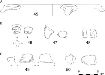
Fig. 12. Further evidence for later prehistoric sites from PVPB28, GMPT13–15 and GMPT29 (scale 1:3). (Drawing: author.)

Fig. 13. The hypothetical shift in settlement patterns from the late neolithic–early middle bronze age open sites to the larger, less dense, naturally defended middle bronze age sites in the Nepi area. (Illustration: author, after the Carta Tecnica Regionale.)
Table 7. The date ranges of the finds from the Nepi Survey Project between the Late Neolithic and Middle Bronze Age.

The rectangular concentration at M13/2 and the circular one at M13/1 may relate to late neolithic and eneolithic houses. The visible crop-marks at these concentrations suggest structures below the surface and allow this comparison. For example, three sub-rectangular and rectangular houses were excavated at Quadrato di Torre Spaccata in Rome (Anzidei and Carboni, Reference Anzidei and Carboni2003), whereas circular houses are known from the site of Osteria Curato — Via Cinquefrondi (Anzidei and Zarattini, Reference Anzidei and Zarattini2007: 86, fig. 5). Four oval and one sub-circular early eneolithic houses were found at Le Cerquete — Fianello (Fugazzola Delpino et al., Reference Fugazzola Delpino, Manfredini, Martini, Radi, Santi and Silvestrini2003: 102). The areas of houses at Quadrato di Torre Spaccata were smaller (6 × 9 m and 6.5 × 8 m; Anzidei and Carboni, Reference Anzidei and Carboni2003: 798) than the concentration at M13/2, but a sub-rectangular hut at Scarceta di Manciano, dated to the Middle Bronze Age and the Grotta Nuova phase (Grifoni Cremonesi, Reference Grifoni Cremonesi, Tozzi and Weiss2007: 287), is in the same range (being 10 × 4.4 m).
MIDDLE BRONZE AGE
Of the concentrations defined by the Nepi Survey Project, CFV10 has clear evidence of the early Middle Bronze Age, and the two handle fragments from PVPB25 have good parallels from south Etruria from the same sub-period. The possibly Apennine sherd from GMPT13–15 relates to a potential undefended site on the fringes of a hillock overlooking a river valley.
Of the previously known sites, Il Pizzo was settled over the entire span of the Middle Bronze Age. Unfortunately, it is impossible to say if GMPT42 was settled during all phases. However, Il Pizzo and GMPT42 share a similar location on a naturally defended tuff outcrop with the nearest undoubtedly middle bronze age sites at Monte Tufo (di Gennaro, Reference di Gennaro, Andraschko and Teegen1990: 216–17; di Gennaro, Reference di Gennaro1992: 710; Belardelli et al., Reference Belardelli, Angle, di Gennaro and Trucco2007: 312, no. 388) between Nepi and Sutri, and at Vignale (Belardelli et al., Reference Belardelli, Angle, di Gennaro and Trucco2007: 284, no. 271), which was settled only during the Apennine phase (Middle Bronze Age 3). Similarly, La Ferriera, on a naturally defended site south of Sutri near Lake Monterosi, also may have a middle bronze age phase (Belardelli et al., Reference Belardelli, Angle, di Gennaro and Trucco2007: 312, no. 386). In general terms, these sites conform to the pattern of settlement slowly concentrating in well defined easily defendable locations at medium intervals (c. 5–20 km) (cf. Fig. 13).
RECENT AND FINAL BRONZE AGE
The nearest recent bronze age sites were located at La Ferriera (di Gennaro, Reference di Gennaro and Negroni Catacchio1995a; Belardelli et al., Reference Belardelli, Angle, di Gennaro and Trucco2007: 312, no. 386) and Narce (Peroni and Fugazzola, 1969; Potter, Reference Potter1976; Belardelli et al., Reference Belardelli, Angle, di Gennaro and Trucco2007: 312, no. 386). Il Pizzo (Nepi area) may have been uninhabited between the Middle Bronze Age 3 and the Final Bronze Age.
Even if one shoulder fragment from the Piano di Vallescura area can be related to final bronze age parallels, most prehistoric pottery from PVPB7–11 can be dated loosely between the Late Neolithic and Middle Bronze Age. However, Orientalizing finds from this area, together with a cooking-stand fragment from PVPB28, show that Piano di Vallescura was an important area for long-term settlement.
Il Pizzo and Torre dell'Isola/Torre Stroppa were the main final bronze age sites in the area, both dated to the end of the Final Bronze Age without any diagnostic pieces dated securely to the earlier sub-phases. However, re-examination of the diagnostic material from the intensive survey of Il Pizzo allows me to suggest an early final bronze age phase.
The other sites in the region are Narce (Peroni and Fugazzola, 1969; Potter, Reference Potter1976; Belardelli et al., Reference Belardelli, Angle, di Gennaro and Trucco2007: 312, no. 386), Vignale (Belardelli et al., Reference Belardelli, Angle, di Gennaro and Trucco2007: 312, no. 386) and Sutri (Belardelli et al., Reference Belardelli, Angle, di Gennaro and Trucco2007: 313, no. 385). These are all in similar naturally defended locations (Fig. 14). This pattern suggests that settlement aggregated on naturally defended smaller tuff outcrops or plateaux, c. 5–10 kilometres apart.

Fig. 14. Recent and final bronze age sites in the Nepi area. (With the Istituto Geografico Militare elevation data, reproduction authorization no. 4706.)
EARLY IRON AGE
The surface collection only gave the rarest hints of the early iron age land use in the Nepi area. Only two locations in the territory had possible early iron age finds. M8 in the Massa area relates to the funerary areas in the immediate surroundings of Nepi, whereas the cooking-stand fragment from the Piano di Vallescura area may relate to the more numerous Orientalizing finds at PVPB7–11. Nevertheless, these meagre finds point to the wider occupation of the territory — if not during the Early Iron Age, then probably during the Orientalizing expansion.
The relocation of settlement from Il Pizzo to Nepi can be considered in the light of the general move towards larger naturally defended sites during the Early Iron Age. Although the recent finds give hints that the use of Il Pizzo continued, its function changed from residential to ritual (Rajala, Reference Rajala2007: 23–5; di Gennaro et al., Reference di Gennaro, Rajala, Rizzo, Stoddart, Whitehead, Patterson and Coarelli2008). A settlement hiatus between the Final Bronze Age and the eight century bc similarly has been recorded at Vignale (Falerii Veteres) and La Ferriera, with Sutri apparently becoming unoccupied after the Final Bronze Age (Belardelli et al., Reference Belardelli, Angle, di Gennaro and Trucco2007). This latter shift seems anomalous, but may relate to power shifts either locally between Veii and smaller centres or regionally between different larger centres. The continuous occupation of Monte Sant'Angelo (Belardelli et al., Reference Belardelli, Angle, di Gennaro and Trucco2007: 24, no. 222), west of the Baccano crater, from the Final Bronze Age to the Early Iron Age may suggest more complex developments at the frontier between the Etruscan and Faliscan areas, as I have suggested elsewhere (Rajala, Reference Rajala, Attema, Nijboer and Zifferero2005; Reference Rajala, Stoddart and Cifani2012).
The possible continuity at Il Pizzo from the Final Bronze Age into the Iron Age raises the prospect that the reason for the dislocation of settlement was organic, due to expanding population. Population estimates and calculations of agricultural production (Rajala, Reference Rajala2004) can be used to support this argument. Since the building density at this site is not known, this information has to be inferred from the evidence from excavations elsewhere in central Italy.
The excavations at Calvario, Tarquinia (Linington, Delpino and Pallottino, Reference Linington, Delpino and Pallottino1978) revealed larger oval and smaller rectangular buildings that can be interpreted as dwellings (the final bronze age houses at Sorgenti della Nova, see: Negroni Catacchio, Reference Negroni Catacchio1995) and auxiliary buildings (for the Fidene and Cures ‘huts’, see: Bietti Sestieri and De Santis, Reference Bietti Sestieri and De Santis2000; Guidi, Reference Guidi2003) respectively, creating an analogous household unit to that at the early iron age Palatine Hill (Carandini, Reference Carandini and Drago Troccoli1998). The building density at Calvario seems to have been ten houses per hectare, if they were all contemporary. With at least three large oval houses per hectare, it is likely that there were c. 3.3 households per hectare. Using the traditional family size of five (Bintliff, Reference Bintliff and Attema2002: 158), the population density during the Final Bronze Age could have been as low as 16.5 persons per hectare. Using an average size of the simulated prehistoric families (Gregg, Reference Gregg1988), utilized in agricultural modelling, the population density could have been 18.7 persons per hectare. Il Pizzo (c. 0.8 ha) could have had potentially three or four households with a population of 20 or 22. If this building density is projected to Nepi (c. 13.62 ha), the iron age population, at the point when the whole site was evenly occupied, could have been 255 people in 45 households. This figure is in line with the estimates presented by Bietti Sestieri (Reference Bietti Sestieri1992b: 236).
These figures are very low in comparison with recent population density estimates (Guidi, Reference Guidi2003), but when they are used to calculate the agricultural land needed to support the population during the two periods (Rajala, Reference Rajala2002), representing the before and after stages of the dislocation of settlement at Nepi, a surprising result emerges. If one assumes that domestic animals were grazing forest pasture, the area required to support the final bronze age population at Il Pizzo (c. 66.81 ha; Fig. 15A) reached the boundaries of the hypothetical territory, drawn with Thiessen polygons. Settling Nepi could have solved any tensions between the final bronze age communities in the area; the land requirements of the early iron age population at Nepi were met inside its hypothetical territory (Fig. 15B). If this case is projected across the relatively densely populated final bronze age southern Etruria, demographic pressure seems a likely reason for the well-documented change in the settlement pattern, and can be used to explain the concentration and centralization of settlement onto the sites of the future Etruscan city-states. The new finds from the Nepi Survey, presented above, support the hypothesis that the early stages of this development had started already during the Middle Bronze Age.

Fig. 15. A. The total modelled area needed for agricultural production for final bronze age Il Pizzo. B. The total modelled area needed for agricultural production at iron age Nepi. In both cases the use of forest pasture rather than grass pasture for the domestic animals is assumed. (After Rajala, Reference Rajala2002: figs 7.13 and 7.15.)
CONCLUSIONS
The new observations from the Nepi Survey Project include a possible eneolithic house site in the Massa area (M13/1), a large eneolithic site with a Rinaldone arrowhead in the Piano di Vallescura area (PVPB7–11), a series of open undefended settlement sites mainly in the western side of the territory in the less dissected area, and a new naturally defended middle bronze age site (GMPT42). The two possible early iron age find-spots, in the Massa and Piano di Vallescura areas, show the importance of these two sectors in the territory.
The prehistoric ceramic finds from the Nepi Survey Project consist mainly of abraded body sherds and more diagnostic simple, long-lived pottery types (Tables 3 and 4). The local settlement history conforms to the general trajectory in South Etruria. The number of open undefended settlements potentially at short distances from each other diminished over time, with settlement concentrating in fewer larger sites from the Middle Bronze Age onwards. By the Final Bronze Age local communities had settled a few medium-sized naturally defended sites that apparently disappeared at the beginning of the Early Iron Age.
Although the major discontinuity and dislocation between the Final Bronze Age and the Early Iron Age cannot be dismissed, the vague indications of continuity at Il Pizzo from the Final Bronze Age into the Iron Age (Rajala, Reference Rajala2007: 23–4), together with the population calculations and agricultural modelling presented above (pp. 28–9), may suggest that this change was not a break but an organic shift related to the expansion of local communities in several neighbouring areas. The possible systematic dating bias between the Final Bronze Age and Early Iron Age, referred to above (p. 11), was not explored by Barbaro (Reference Barbaro2010). The transition from one period to another will need re-examination in order to clear any doubt over settlement hiatus or continuity. If future fieldwork can find more ninth-century bc finds or any evidence of the Iron Age and Orientalizing period at Sutri, the settlement history of southeastern Etruria and the Faliscan area could prove to be more complicated, with a network of smaller peer polities north of Veii during the Iron Age (cf. Rajala, Reference Rajala, Attema, Nijboer and Zifferero2005).
Acknowledgements
This research was carried out with a concession from and in close collaboration with the Soprintendenza per l'Etruria Meridionale, under the supervision of Dott.ssa Daniela Rizzo. The survey was supported and assisted by the British School at Rome and its staff, together with the mayor and personnel of the Comune di Nepi. I am grateful to Simon Stoddart, the director of the original Nepi Survey Project, for his support; and thank the British Academy and the McDonald Institute for Archaeological Research, Cambridge, for granting funding for the original fieldwork. In addition, I could not have studied this material without the survey teams of 1999 and 2000.
I ran the survey in the field as part of my Ph.D. research, with financial support from the British Academy, the Academy of Finland, New Hall (Cambridge), the Cambridge European Trust, the Finnish Cultural Foundation, Worts Travelling Scholars' Fund, the Garrod Fund, the Prehistoric Society, the Society of Antiquaries of London, George Charles Winter Warr Scholarships and Ridgway-Venn Travel Studentships.
The study phase also received assistance from the Museo Civico di Nepi and its Director, Stefano Francocci, as well as the Museo Archeologico dell'Agro Falisco (Civita Castellana) and its staff.
I should also like to thank the Editor, the anonymous reviewers and the British School at Rome's Publications Manager for their comments and suggestions, which improved the paper.
APPENDIX 1.
The field observations of the characteristics of the site and concentration areas.
Key:
Land use codes refer to the USGS hierarchical land use categories. 200 = Agriculture
Visibility percentage refers to the proportion of the field surface visible
Find density refers to the general find density of a field unit
Aspect refers to the cardinal direction to which a field unit faces
Slope categories classify the average observed gradient angle of a field unit. In degrees: 0–1 = level; 2–3 = gentle; 4–7 = sloping; 8–11 = very sloping; 12–15 = moderately steep; 16–25 = steep; 26–35 = very steep; 36 + =precipitous. Rolling means that the unit contains variable slopes in different parts.


