

Sala: an introduction to the town's history, archaeology, past and new research (S.C., N.M., R.P.)
The site of Sala lies on the outskirts of the modern city of Rabat, the capital of Morocco, approximately 3.5 km from the mouth of the Oued Bou Regreg. In ancient times, it was part of the Roman province of Mauretania Tingitana and was located near its southern border (Figure 1). The settlement covers an area of ca. 1.2 ha and is situated on the slope of a hill. Evidence from different historical periods coexists within the archaeological site: a circuit of walls, dating from the Marinid era, encloses the remains of the Islamic funerary complex (khalwa) of Chellah as well as those of the pre-Roman and Roman town of Sala (Figure 2).Footnote 1 The extant edifices of the ancient urban centre include public, religious, and commercial buildings that developed around a paved area. The layout of the Roman-period civic centre and its buildings as visible today correspond essentially to the shape they had acquired by the end of the second century AD.

Figure 1. Map of Mauretania Tingitana with location of main towns (image R. Pansini, edited source of World Terrain Base: ESRI, USGS, NOAA).

Figure 2. Sala-Chellah: map of archaeological site enclosed by Marinid walls (image R. Pansini).
Sala's history is related to that of Mauretania. The pre-Roman (Mauretanian) phase encompasses a broad period from the eighth century BC to the late first century BC, although the preserved architectural evidence from Sala only seems datable to the last part of it. At this stage Mauretania extended from the shores of the Atlantic Ocean to the frontier of the Numidian kingdom. When its last king Bocchus II died without heirs in 33 BC, this territory was bequeathed to Rome. After a short interregnum, in 25 BC the emperor Augustus entrusted the government to Juba II, the son of Juba of Numidia, establishing a client kingdom in the region with formal administrative and political autonomy, but subject to Rome's control. This form of government was maintained after Juba's death in AD 23, when the kingdom passed to his son Ptolemy, who remained in power until his murder at the behest of Caligula in AD 40. After a period of civil unrest, the territory was eventually divided into two provinces by the emperor Claudius, ca. AD 42–43: Mauretania Caesariensis, corresponding to the eastern part of the kingdom (northern Algeria), with Iol-Caesarea as a provincial capital; and Mauretania Tingitana (northern Morocco), with Tingi as its capital.Footnote 2 Sala became part of Tingitana along with the other towns of the western territory. Following their inclusion into the Roman Empire, these towns witnessed a major urban development, which reached the most flourishing phase in the second and third centuries AD through the construction of public spaces and monumental buildings. This process led to the destruction of some of the earlier edifices, and to the reuse and enhancement of others.
The site of Sala has been investigated by French research teams, who brought to light all the structures that one can see today. The first excavations within the Marinid walls were commissioned by the director of the Service des Antiquités du Maroc, Louis Chatelain, and took place under Jules Borély and Kadija Fouad Riaz Bey in 1929–30. Excavations brought to light Islamic-era monuments and some of the Roman ones (a building with nymphaeum, Building F, an honorary arch, and part of a bath complex), but no reports or excavation journals exist to record these activities.Footnote 3 The second major phase of archaeological excavations was carried out by Jean Boube over a long span of time from 1958 to 1996. Thanks to these works, the other extant buildings within the ancient civic district were discovered: the Capitolium, the three-terraced complex of Temple A, Building D, and Temples/Buildings B–C (Figure 3). Regrettably, like his predecessors, Boube did not publish a comprehensive synthesis of his research.Footnote 4

Figure 3. Sala: map of Roman civic centre. 1: Temple A; 2: Piazza/Forum; 3: Building H (probable location of reburied structures); 4: Temple/Building B; 5: Temple/Building C; 6: Building D; 7: Baths; 8: Building with nymphaeum (Building L); 9: Capitolium; 10: Building G1; 11: Building G2; 12: Honorary arch; 13: Building F (image R. Pansini).
Since 2011, a series of international collaborative projects have resumed the analysis of Sala's monuments. This ongoing research has looked at the features of the town's architecture and urbanism, applying a range of methodologies: on-site architectural and archaeological analyses; the creation of 3D digital models based on the results of fieldwork; archival research in Rabat, Morocco (Photothéque de la Division du Patrimoine Culturel) and Aix-en-Provence, France (Centre Camille Jullian); the study of the edifices’ architectural ornamentation and their epigraphic apparatuses. Thanks to the results of part of this research, the aim of this article is to look at the evolution of Sala's townscape, to investigate how the addition or transformation of public buildings through time shaped the perception of the built environment within this expanding urban setting. The time frame under consideration spans from the late first century BC to the latter half of the second century AD, during which we can identify building activities encompassing the late Mauretanian (Figure 4a) and Roman imperial periods (Figures 4b–d). The discussion throughout the text is based on select evidence from Sala's civic district, which has provided sufficient information to attempt this assessment. A study of the visual impact of architecture, supported by 3D reconstructions of these buildings, offers an insight into the use of public spaces in antiquity, how these were experienced, and how their modification through time responded to the new requirements of the local urban community and municipal authorities. Ultimately, the goal is to attempt to outline the broader, social and political relationship between Sala's monuments and its governing body, regarding the built space as a container of cultural messages that were transmitted to the society. By constructing and observing buildings, especially monumental ones, the community found images, shapes, and concepts that had become part of a well-defined cultural horizon with which it was led to empathize. Indeed, as stated by Paul Zanker (Reference Zanker1998, 3), ‘a townscape also represents the framework within which urban life takes place. It not only shapes the inhabitants but is shaped by them, for the buildings and spaces, having been constructed to embody certain messages and values, continue to communicate these same messages to succeeding generations’.

Figure 4. Sala: main building phases of civic centre (grey elements continuing in use from previous phases; black elements representing new developments). A: Mauretanian (first century BC); B: Roman 1 (late first – early second century AD); C: Roman 2 (first half of second century AD); D: Roman 3 (second half of second century AD and later) (image R. Pansini).
From a Mauretanian sanctuary to the town's forum (R.P., N.M.)
The Mauretanian and early Roman period: an open terraced area (R.P.)
The earliest building activities in Sala's civic district date back to the Mauretanian period; they might have taken place throughout the first century BC, although a more precise date is impossible to determine. All the buildings belonging to this phase have compatible orientations and are located at the east and west ends of the excavated area (Figure 4a), which we can imagine as a large open space. Thanks to the recent analysis of architectural and stratigraphic relationships, construction techniques, archaeological and archival data, this period can be divided into two sub-phases (Pansini Reference Pansini2018–19, 63–80, 149–50). The first sub-phase includes the original structure of Temple A, which was formed by three adjacent cellae. To the second sub-phase have been attributed the enlargement of this edifice, which became a five-cellae temple (Figure 5), and the buildings located to the south of it below the intermediate terrace and Building H, which are no longer visible because they were reburied after the excavations (Bekkari Reference Bekkari1967, 659–60; Reference Bekkari1968–72, 248). At the western end of this area, the construction of a water storage structure underneath Building L, of which only scant traces of masonry in square blocks remain, can also be attributed to this phase.

Figure 5. Temple A: extant remains of cellae and pronaos, view from south-west (photo S. Camporeale).
The difference in height between these structures suggests that already in this Mauretanian phase the civic centre was articulated on terraces to adapt to the shape of the hill. The communication routes between these terraces, in particular between Temple A and the structures to the south of it, remain to be clarified. In this period, one can recognize a mixture of building techniques probably related to the different uses of these edifices. The cellae of the temple are made of roughed-out stones of different size, laid out without lime mortar and provided with numerous splinters (‘mur à parement dressé’ in Boube Reference Boube1967, 302–4; Camporeale Reference Camporeale2004, 200, Figure 2, no. 6; ‘technique VIII.1.2’ in Camporeale Reference Camporeale2004–05, 253–55, 263–64, pl. 32), while the building's façade was probably made in ashlar masonry (opus quadratum). In contrast, the buildings located south of the temple featured stone socles and raw brick elevations (Boube Reference Boube1967, 309–12), while the water storage structure underneath Building L is made of square stone blocks with a hydraulic coating (‘technique VIII.3.2’ in Camporeale Reference Camporeale2004–05, 257–58, 265–66, pl. 33). The only architectural members that can be related to this phase are two Ionic half-column capitals, a single drum of a half-column shaft, and eight blocks of an Egyptian gorge cornice, which can be reasonably attributed to the façade of Temple A (Boube Reference Boube1967, 320, 326–30, pl. 19.1–2, Figures 5, 16; Mugnai Reference Mugnai2018, 138–40, 276, no. Sal 2.3, Figure 6.3, pl. 37) (Figure 6). Due to the porosity of the calcarenite that was used for carving them out, layers of stucco would have been applied to the surface to give them a more refined appearance.

Figure 6. Temple A: architectural ornament. A: Egyptian gorge cornice (photo N. Mugnai); B: Ionic capital (photo N. Mugnai); C: 3D reconstruction of upper part of temple façade (image R. Pansini).
The attempted reconstruction of the temple elevation is based on the portions of masonry still preserved in situ, the presence of these elements of architectural decoration, and the information that can be drawn from Boube's excavations. The association of Ionic capitals with Egyptian gorge cornices is found in other pre-Roman buildings in North Africa, such as the Monument of Atban at Thugga and other structures in the town's Numidian-era civic centre (Rakob Reference Rakob, Günter and Rüger1979, 157–58; Aounallah and Golvin Reference Aounallah and Golvin2016, 47–58; Golvin et al. Reference Golvin, Aounallah, Brouquier-Reddé, Maurin, Baratte, Brouquier-Reddé and Rocca2018, 18–21), as well as in Temple B at Bulla Regia (Ksouri Reference Ksouri, Baratte, Brouquier-Reddé and Rocca2018).Footnote 5 The height of the half-columns was calculated from the preserved diameters of the shaft and capital, corresponding to 0.514 m (ca. one cubit) and 0.48 m respectively. In the absence of any available data from the local architecture of this period, the reconstruction had to apply Vitruvian canons, which prescribe a ratio of 1:10 between the diameter of the shaft and the total height of an Ionic column; in this case the height would be 5.14 m (10 cubits). A smooth frieze joint to the cornice (total height 0.44 m) was placed above the half-columns. The roof above the cellae was probably constituted by a flat terrace, which is considered a typical component of the sacred architecture of this period, as suggested by iconographic evidence of temples with this layout depicted on Mauretanian coins.Footnote 6 There are no data to understand whether the temple had a porch with independent columns on the pronaos, as it has been hypothesized for other multi-cellae sacred buildings in Tingitana (cf. the forum temple at Banasa: Euzennat and Hallier Reference Euzennat and Hallier1986, 81). The resulting total elevation of temple and pronaos is 9.24 m, corresponding to 18 Punic cubits.Footnote 7
The cult of Temple A and its architectural language (N.M.)
A connection between Temple A and the cult of Mauretania's client kings, Juba II and his son Ptolemy, may be plausible on the basis of the discovery of sculptures in this area. A marble statue of Ptolemy in heroic nudity was found during the excavations of the temple in 1960 (Figure 7); it was broken in various fragments that were recovered inside rooms 2 and 3 of the building (Boube Reference Boube1990b; Landwehr Reference Landwehr2007, 99–103). In 1964, a small marble head of Juba II was brought to light in a structure located near the eastern gate of the later Roman piazza, ca. 15 m to the south-east of Temple A (Boube Reference Boube1966a). One should bear in mind that the question of a royal cult of Mauretania's kings is still debated. The existence of an official cult has been regarded with scepticism by some (Histoire du Maroc, 110; contra Roller Reference Roller2003, 155–56), while others have hinted that the finds from Sala may point to the presence of a political cult associated with the client kings in this town (Coltelloni-Trannoy Reference Coltelloni-Trannoy1997, 198–99). It is not to be excluded that the exceptionality of these discoveries may suggest a special status of Sala within Mauretania. In any case, if this hypothesis of identification of the cult is correct, the prominence of the building as a dynastic sanctuary would have been emphasized by its position on the sloped terrace, overlooking the valley of the Oued Bou Regreg underneath. This layout recalls quite closely the topographic features of the Monument/Temple of Massinissa in the so-called ‘Numidian agora’ at Thugga (latter half of the second century BC), whose location was evidently meant to have a strong visual impact over and from the Khalled valley (Ardeleanu Reference Ardeleanu2021, 223–28, with previous bibliography). One can therefore suggest a link and continuity of those architectural and cultural traditions which the literature has labelled, more or less convincingly, as ‘Numidian Royal Architecture’ (cf. Rakob Reference Rakob, Günter and Rüger1979; Coarelli and Thébert Reference Coarelli and Thébert1988; and the critical reassessment in Quinn Reference Quinn, Quinn and Prag2013).
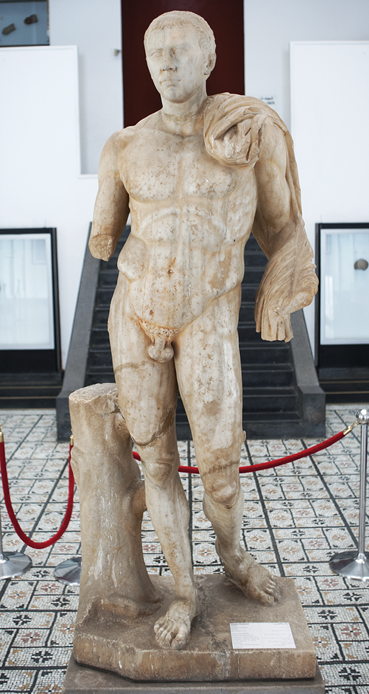
Figure 7. Marble statue of Ptolemy, Musée de l'Histoire et des Civilisations de Rabat (photo R. Pansini).
This impression seems strengthened if one looks at the features of the architectural decoration of Temple A. The Ionic capitals are poorly preserved, but originally they would have not looked too dissimilar from those of the so-called ‘Tomb of the Christian Woman’ (Kbor er Roumia) near Tipasa (Figure 8) – a mausoleum of debated chronology, which has been attributed either to the Mauretanian dynasts of the late second/early first century BC or to Juba II himself (Rakob Reference Rakob, Günter and Rüger1979, 138–42; Coarelli and Thébert Reference Coarelli and Thébert1988, 765–66; Quinn Reference Quinn, Quinn and Prag2013, 185–86). It is important to remark that this form of Ionic capital did not die out altogether with the assimilation of the North African regions into the Roman Empire, which highlights the relevance of this type of ornamentation not just from an architectural standpoint, but also from a broader cultural perspective.Footnote 8 For instance, echoes of these shapes can be seen on the north-west temples in the Old Forum of Lepcis Magna, late first century BC to early first century AD, and reworked versions can still be recognized on some mausolea of the Tripolitanian pre-desert dating well into the third and fourth centuries AD.Footnote 9 The use of this type of ornamentation on Temple A may be regarded as a reference to the fashion and architectural language of the Numidian world, given the familial ties that Rome's client kings in Mauretania had with this region (Juba II was the son of Juba of Numidia). The occurrence of this decorative style on a sanctuary that may have been dedicated to the royal cult was thus a choice that would have allowed an immediate identification of the role and sacrality of the building. Unfortunately, almost nothing is known about the elevation of the other Mauretanian-period edifices at Sala, but it seems unlikely that they would have matched the prominence and decorative richness of Temple A. Therefore, the easily recognizable architectural features of the temple must have shaped to some extent the viewers’ perception of the monument within this urban context, even if just unconsciously.

Figure 8. Kbor er Roumia, ‘Tomb of the Christian Woman’: Ionic capital (photo M. Williams, Manar al-Athar).
The Roman imperial period: leading to monumentality (R.P.)
The transition to the Roman imperial period shows a progressive monumentalization of the area. It seems clear that the conformation of the terrain had a strong influence on the construction of buildings, which were built with divergent orientations and their layout was affected by the hill slope. This phase can be dated towards the end of the first – beginning of the second century AD, and it includes the construction of a new monumental complex enclosing Temple A (Figure 4b).Footnote 10 These operations determined the disappearance of some of the earlier buildings. The structures on the south side of the temple were obliterated under an earth fill during the construction of a paved square above them (ca. 930 mFootnote 2). This square was buttressed on the south side with a row of 10 irregularly sized rooms (tabernae) with vaulted roofs, which functioned as substructures opening towards a street running on the lower level. Given the presence of lime mortar in their masonry, the construction of Temples/Buildings B and C, of which only the foundation walls are preserved, may also date to this phase.Footnote 11 A first monumentalization of the building with nymphaeum (Building L) can be attributed to this period too; this is shown by the construction of a podium made of square blocks with a moulded cornice, of which only a few courses remain.
At this stage Temple A was the most conspicuous public building one could see (Figure 9). The five-cellae edifice was maintained, although it was now provided with a large paved, and probably porticoed, square to the front. Given the evident public function of this piazza, it is reasonable to identify it with the town forum. This space was enclosed by a wall, which embraced the piazza on its two long sides, and was accessible through two passages to the east and west. The temple, which used to rise above the other structures as a standalone monument in the previous phase, was now included within a more articulated complex, which developed on three terraces and therefore responded to new demands for monumentality.

Figure 9. Temple A and Roman piazza: extant remains, view from south-west (photo S. Camporeale).
As for the entrances to the piazza, given the presence of large concrete platforms in correspondence with the east and west road axes, it can be assumed they were adorned with monumental arched gates. The problem of the difference in height between the level of the square and that of the area to the westFootnote 12 was probably resolved through two staircases placed at the entrance and exit of this propylaeum, reconstructed with two and three steps respectively. The east entrance platform, in contrast, has an inclination compatible with the presence of a ramp. The presence of a portico in the portion of the piazza south of the two entrances can be hypothesized thanks to the architectural survey carried out by Gilbert Hallier during Boube's excavations of the area in 1962–63. Hallier documented some traces of the paving in that spot which are no longer observable today; his drawings show that the slabs in this section had a different orientation from those of the rest of the square, which would be compatible with the presence of a porticoed area. In a later phase (mid-second century AD?), two lateral staircases were added, connecting the piazza to the temple (Figures 4c, 10–12). These have been reconstructed on the basis of the extant steps, which have an average width of 0.37 m and a height of 0.243 m. A further room inserted under the new podium might have been a sort of thesaurus or place of worship and must have been covered by a flat roof to ensure the continuity of the floor of the pronaos above. The construction of the staircases led to the destruction of some rooms that were originally placed along the sides of the square (their posteriority is demonstrated by the fact that they were built over the walls’ levelling). Before the construction of the two staircases, access to the temple was probably guaranteed by a door that opened onto the alley running along the north-east side, which led directly to the pronaos. We do not know, however, how the piazza and temple were connected at this stage, if at all.

Figure 10. Temple A and Roman piazza: reconstructed plan (third phase, ca. second century AD). A: temple and forum square on upper levels; B: lower level with tabernae (image R. Pansini).

Figure 11. 3D reconstruction of Temple A (third phase, ca. second century AD): façade and podium, view from south-east (image R. Pansini).

Figure 12. 3D reconstruction of monumental complex enclosing Temple A (third phase, ca. second century AD), view from south-west (image R. Pansini).
The meaning of Temple A in the Roman period: continuity and integration (R.P., N.M.)
Given its survival over time, we can assume Temple A was an extremely important building within the townscape, and because of its relevance it was not only maintained but also enhanced. Finds of statues suggest the original structure could have been associated with a form of worship of the Mauretanian kings, while subsequently the imperial cult might have been added (Boube Reference Boube1990b, 360; Brouquier-Reddé et al. Reference Brouquier-Reddé, El Khayari, Ichkhakh, Khanoussi, Ruggeri and Vismara2004, 1897). A seamless continuity of cults may also be suggested by the practice of adding statuary groups to the interior or exterior of the temple throughout the imperial period.Footnote 13 This finds further confirmation in an inscription (no. 9: IAM 310) discovered in situ on the apsidal structure at the back of room 4 (Figure 13). Probably dating to the second century AD, it is a small base with the name of the sevir Postumius Octavianus who dedicated a statue cum aede et valvis (a cella and its door), most probably as part of a series of restoration works involving the temple at that stage. Statues were also added to embellish the forum piazza, as shown by an inscribed statue base dedicated to L. Minicius Pulcher by his amici Salenses around AD 140 (no. 4: IAM 304).

Figure 13. Inscription of Postumius Octavianus, IAM 310 (photo N. Mugnai).
The maintenance of temple structures and the multiplication of cellae to meet the new needs of the cult is a phenomenon that can be observed in other towns of Tingitana, such as Banasa, Volubilis, Zilil, and Lixus. Recent research on the buildings in the forum of Banasa dates the construction of the first sacred edifice around the Augustan era or shortly after; this temple was divided into three cellae preceded by a transversal pronaos with columns, which was accessed via a lateral staircase (Brouquier-Reddé et al. Reference Brouquier-Reddé, El Khayari, Ichkhakh, Khanoussi, Ruggeri and Vismara2004, 1887–90). The monumentalization of the forum in the following period, ca. late first – early second century AD, did not result in the destruction of this structure, but rather in its remodelling and integration within the new complex. The temple was provided with four more cellae, which were built in accordance with the divergent axis of the earlier construction, and this also affected the configuration of the square in front of it, which took on a trapezoidal shape (Brouquier-Reddé et al. Reference Brouquier-Reddé, El Khayari, Ichkhakh, Khanoussi, Ruggeri and Vismara2004, 1891). The forum of Volubilis features a structure known as Temple D (Jodin Reference Jodin1987, 170–72; Brahmi Reference Brahmi, Ouachour, Pimouguet-Pédarros and Clavel-Levêque2016), whose articulation in four cellae dates to the second century AD and is believed to have replaced previous Mauretanian and early Roman constructions. Two temple structures with elongated cellae were to be found in this spot around the mid-first century BC, placed side by side and with a single pronaos on front accessible by two separate staircases facing the square (Brouquier-Reddé et al. Reference Brouquier-Reddé, El Khayari and Ichkhakh2001, 189; Reference Brouquier-Reddé, Ichkhakh, El Khayari, Baratte, Brouquier-Reddé and Rocca2018, 58–60).Footnote 14 At a later stage, these edifices were replaced by a two-cellae sacred building, which was further modified in the second century AD through the construction of the larger temple with four cellae. On the north terrace of Zilil, a temple structure dating to the first century AD can also be identified, which was altered in the second century AD to become a complex with four cellae connected through a joint pronaos (Lenoir Reference Lenoir2005, 68–69). Similarly, the sacred area of Lixus (the so-called ‘Quartier des Temples’) saw a remodelling of Mauretanian-era temple structures (Temples B, C, D). A single staircase was created to give access to them during the second half of the first century AD (Brouquier-Reddé et al. Reference Brouquier-Reddé, El Khayari and Ichkhakh2001, 190; Reference Brouquier-Reddé, El Khayari, Ichkhakh, Akerraz, Ruggeri, Siraj and Vismara2006, 2164–66), in connection with the new role of the area located to their east, which was probably meant to host a public square (Pansini Reference Pansini2012–13, 134–37).
The case of Sala, where a form of cult of the client kings could have been supplemented by cults of Roman imperial origin, may help to explain this phenomenon of multiplication of cellae more broadly. At Banasa, the discovery of statuary fragments has led some to hypothesize that the first-phase temple might have been a Capitolium, which was later used to house the imperial cult.Footnote 15 Similarly, the cult of the ruling emperors has been suggested for Temple D at Volubilis.Footnote 16 The increase in the number of cults may have consequently led to an increase in the number of cellae and to the transformation of the previous complexes according to canons closer to Roman imperial architecture. The new need for monumentality would have been solved by joining the rooms with high transverse podia and by building porticoed squares in front of these temples.
Apart from the addition of a piazza and annexed structures, it is important to observe that no traces of a reconstruction of the façade of Temple A during the imperial period can be recognized. It seems plausible that the building kept its original elevation with Ionic half-columns and Egyptian gorge cornices, which would have been restored periodically (a very thick layer of stucco on one of the cornice blocks may attest to such restorations). This ‘old-fashioned’ look of the temple would have contrasted with the more recent architectural additions to the forum square, but this could have been an intentional choice to respect and highlight the ancestry of the edifice and the cults that were worshipped in it. In this regard, one may point out again a potential similarity with the buildings at Thugga. In contrast to previous hypotheses, a recent restudy of the local forum has argued that the Monument/Temple of Massinissa was left in place unaltered until the end of the second century AD. If true, this building would have occupied a conspicuous position in a public area that was surrounded by imperial-period constructions, including the Capitolium (Ardeleanu Reference Ardeleanu2021, 233–35). Similar observations apply to the Old Forum of Lepcis Magna. Around the mid-second century AD, the façades of the main temples and public buildings in the piazza were renovated with marble architectural ornamentation. However, it appears that the ‘Temple of Milk'Ashtart-Hercules’ (North Forum Temple) was left unchanged with its original limestone architectural elements, thus creating a sharp visual contrast with the other edifices next to it (Mugnai Reference Mugnai2021, 109–10).
Only at a later stage would some modifications and remodelling occur, especially to the podium of Temple A (Figure 4d). Two large pedestals were added on the square, one of which caused a partial cutting of the eastern staircase that gave access to the temple above. Unfortunately, the available data do not allow us to propose a precise chronology for these transformations, other than a generic post-second-century AD date, which is confirmed by the evident posteriority of the pedestals to the square paving. Two inscriptions also attest to the continued use of this public space at a late date. The base of L. Minicius Pulcher was recycled to host a new dedication to Constantine by the res publica Salensium in AD 312–24, and another base was set up in honour of a nobilissimus Caesar perhaps around those years (no. 11: IAM 305).
An expanding townscape: new urban features, public buildings, and their visual impact (S.C., N.M.)
The Roman imperial era: towards new forms of urbanism and architecture (S.C.)
The process of monumentalization underwent by Sala from the end of the first century AD until the Antonine era (Boube Reference Boube1999, 13–19; Mugnai Reference Mugnai2018, 135–54) is comparable with what was going on in the same period in other provinces of North Africa (Hobson Reference Hobson, De Ligt and Bintliff2020). The hill terraces on which the town lies were expanded to accommodate larger buildings (Figure 4c). The new streets and squares were paved using a grey-blue limestone, which was quarried ca. 20 km south of Sala and was more resistant to weathering than the local calcarenite.Footnote 17 As discussed above, it appears that only one of the Mauretanian-era buildings survived, namely Temple A, although it became part of a larger monumental complex (the forum piazza) in the Roman period. All other public buildings in Sala's civic district seem to have been constructed during the early imperial age (Camporeale Reference Camporeale2021, 33–34, 43–48).Footnote 18 These constructions developed around a new square, which was probably created by enlarging a previous terracing, corresponding to the area to the west of Temple A; a retaining wall was built along its southern limit and an earthen fill concealed several pre-Roman buildings. The shape of the square reflects, at least in part, the orography of the terrain. For this reason, it does not look like a planned space and its layout is not entirely regular.
The square extends 76.5 m east-west and 25.5 m north-south, for a total of 1,650 m2. At its eastern end is Temple A, whose monumental gates were already added around the end of the first – beginning of the second century AD. On the opposite western side, a building of uncertain function was erected (Building F),Footnote 19 which is the only structure at Sala that was built entirely in opus quadratum and was most probably of public utility. The building might have been used for economic activities (a market?), or for civic administration (magistrates’ offices?). Even its architectural layout finds no direct comparisons: four rooms on the front open onto the square, with a small room behind them; at the back there are two larger rooms perpendicular to those at the front and perhaps open on the sides (Pansini Reference Pansini and Papiforthcoming a). On the southern side of the square is another building with peculiar characteristics (Building L). It is superimposed on the square's terracing wall and develops on two levels. The long side of the building at the level of the square shows an opus quadratum façade decorated with pilasters and half-columns. At the back, a monumental nymphaeum is placed at a lower level of 5 m; the water basin is circular and the elevation is octagonal in shape, with niches for statues (Pansini Reference Pansini and Papiforthcoming b). An honorific base was discovered inside one of the rooms of this complex, recording a dedication to M. Sulpicius Felix by his amici municipii Salensis in AD 144 (no. 5: IAM 307). The speech in honour of this personage took place in curia Ulpia, and it has been assumed that the building where the base was found must have been the curia itself (Chatelain Reference Chatelain1944, 91–94; Boube Reference Boube1979–80, 125–27). However, the building's unusual layout is incompatible with that of a curia and this hypothesis must be discarded, thus leaving the question of its identification open.
The Capitolium building complex and its architectural revolution (S.C.)
On the north side of this square a Capitolium was built – the largest religious complex in the town (Camporeale Reference Camporeale2021) (Figures 14 and 15). The building faces the square on its long side, has a rectangular plan (ca. 46 × 26 m), and is built on two levels against the slope of the hill. On the lower level there are nine rooms (tabernae), originally covered with barrel vaults (Figure 16). The temple (ca. 22 × 9 m) is located on the upper level at the back of a square surrounded by porticoes on three sides (Figure 17). The Capitolium can be dated to ca. AD 120 thanks to the monumental dedicatory inscription (no. 3: IAM Suppl. 861), various fragments of which were recycled on a fourth-century AD paving (Boube Reference Boube1990a).Footnote 20 From this inscription we learn that the temple was built at the expense of a citizen of Sala, C. Hosidius Severus, a military officer of equestrian rank who is also named in two other honorific epigraphs (nos 1–2: IAM Suppl. 859–60). The building techniques and the architectural decoration of the Capitolium resemble closely those of the building with nymphaeum, so the two edifices can be ascribed to the same chronological phase.

Figure 14. Western part of civic district, view from south-east: Capitolium, building with nymphaeum, honorary arch, Building F (photo S. Camporeale).

Figure 15. Capitolium: reconstructed plan. A: temple and portico on upper level; B: lower level with tabernae (image S. Camporeale; R. Pansini).
Figure 16. Capitolium: lower level with tabernae, view from south-west (photo S. Camporeale).

Figure 17. Capitolium: upper level with remains of temple and portico, view from east (photo S. Camporeale).
The Capitolium is the most conspicuous edifice of Sala's civic district and allows us to advance a series of considerations on its layout, architecture, urban setting, and visual impact. Hosidius Severus probably conceived this building project in agreement with the local authorities, since the temple was part of an interconnected urban programme that included all the streets around it, the water drainage systems, and the surrounding buildings. Some of these edifices indeed show construction techniques that are very similar to the Capitolium, even in the construction details, so one can assume the same workers were involved.Footnote 21 Compared to the constructions preceding the Hadrianic period, the Capitolium's building techniques show a greater uniformity, both in the working and size of the materials, and in the building process itself. In this regard, a comparison with the piazza and other structures that enclosed Temple A at the end of the first – early second century AD is useful. Masonry techniques used in the temple are characterized by a concrete inner core, faced with stones of irregular quadrangular shape and of different size. For this reason, the stones in the wall facings could not be arranged in horizontal rows. In contrast, the design of the Capitolium was unitary, since this complex, unlike Temple A, was planned and built in a single phase. It is evident that the project led to a standardization of construction techniques and processes, precisely because of its large size and the challenges it posed to the designers and workers in terms of aesthetics, monumental impact, and required technologies. Wall facings are made of irregular stones but are roughly uniform in size, and the whole construction was reinforced with piers of opus africanum. The building project relied on the local workforce, but it is evident that the builders had to change their habits to some extent to engage with the construction of such a large monument. Local building traditions were therefore mixed with other practices, such as the use of opus africanum on a large scale, which was widespread at the time across the rest of North Africa, from Mauretania Caesariensis to Tripolitania. In Tingitana, a local type of opus africanum was adopted for large public projects, characterized by the presence of piers made of superimposed headers and stretchers.Footnote 22 Other techniques were imported from across the Strait of Gibraltar, in particular those used for the concrete barrel vaults of the tabernae, where stone arches were employed to reduce the concrete sections and facilitate the construction process.Footnote 23
The standardization of building techniques and the seriality of production of building materials is a phenomenon already known in Roman architecture between the end of the Republic and the early imperial era (Wilson Reference Wilson and Oleson2008). To this we can add the diffusion of similar techniques across vast territories, even with all the variations that were developed at local levels, which is a sign of the presence of stable groups of workers who operated according to more or less uniform procedures. This phenomenon is in turn related to the patrons and local elites’ high status, as well as to the continuous opening of new construction sites, both public and private, and thus to the prosperity of the North African cities especially throughout the second and third centuries AD. It was during this period that the African provinces witnessed the spread of monuments that symbolized the elites’ adherence to the ideals of the Roman Empire, in particular Capitolia and monumental arches (Quinn and Wilson Reference Quinn and Wilson2013, 166; Mazzilli Reference Mazzilli2016, 16–17). The most widespread building techniques that accompanied the adoption of these architectures in North Africa were opus africanum and opus quadratum, exactly like at Sala and in the rest of Mauretania Tingitana (Camporeale Reference Camporeale, Mugnai, Nikolaus and Ray2016).
After the construction of the buildings closing off Sala's civic district towards the west, this area acquired a particular urbanistic connotation, to the extent that it can be identified as a forum novum or forum adiectum (Mugnai Reference Mugnai2018, 41; Camporeale Reference Camporeale2021, 43–46, 167–69). Like in other cities of North Africa, such as Thamugadi and Cuicul (Gros Reference Gros1994), these new areas became more attractive for the development of public buildings, offering new possibilities of self-celebration to wealthy patrons, who could thus display their influence and social importance.Footnote 24 Compared to the old forum of the city, identifiable with the piazza in front of Temple A, the forum novum is a less rigidly structured space, while it is larger and more functional to the needs of the new, imperial-period urban planning. Gradually, various buildings were arranged along its sides. The development of this new forum, which was much accentuated in length, favoured the possibility of creating monumental perspectives and emphasizing the visual role of these architectures. The celebration of the town and of Hosidius Severus, one of its wealthiest citizens,Footnote 25 was among the main objectives of the implementation of this building programme, which went hand in hand with a shift of the central pole of urban planning at Sala and with a renewed spatial perception of its civic centre. The main visual axis of the forum novum was the east-west one, and the two main sanctuaries of the city – the Capitolium and Temple A – constituted the respective focal points at the extremities of this axis.
The monumental scale of the Capitolium, however, cannot be compared to that of Temple A, due to its elevated position overlooking the entire square. The 3D reconstruction of the monument allows to highlight further architectural features and to better understand the impact of this construction on Sala's urban planning (Figure 18). The main (south) façade of the complex faced the forum novum. Together with the temple façade, this is one of the few portions of the building entirely made of opus quadratum Footnote 26 and was therefore conceived as more symbolic and outstanding. The façade can be reconstructed as ca. 15 m in height and the dedicatory inscription of Hosidius Severus might have been placed at the top of the attic on this side of the complex. This is the largest building inscription of Tingitana (8.50 × 1.85 m, as reconstructed by Boube Reference Boube1990a), with letters 25 cm high on the first line, 20.7 cm on the second and third lines, and 21.5 cm on the fourth and fifth lines. The front of the building is decorated with Corinthian pilasters of two different sizes: those on the front of the tabernae's partition walls are 5.44 m tall (total preserved height), while those at the sides of the doors are smaller (3.10 m, hypothetical height). Given the presence of decorative pilasters on the door jambs, small pediments can be reconstructed above the doors of the tabernae, perhaps with alternating triangular and curvilinear shapes. The decorative richness of the façade is not comparable to any other monument in Tingitana, but it can be compared to other large urban sanctuaries in North Africa with their exterior walls decorated with sequences of pilasters (Tomasello Reference Tomasello2011, 92–93). The general scheme of Sala's temple project is a recurrent one and can be traced back to the so-called ‘templa cum porticibus’, which derived from Italic models (i.e., enclosed porticoed squares with the temple raised on a podium in a central position).Footnote 27

Figure 18. Capitolium: 3D reconstruction of monumental complex, view from south-east (image R. Pansini).
This layout followed criteria of axiality and symmetry, which are also shown by the reconstructive view of the upper level of Sala's Capitolium (Figure 19). That said, what makes the Sala temple more interesting is that its perception as an ‘orthodox’ type of temple is altered by some peculiar features that one can identify as local. These depended either on cult particularities or on the choices made by the designers and workers during the construction. The temple, for instance, can be reconstructed as a Corinthian tetrastyle with a very deep pronaos, which was provided with three columns on either side instead of the more common two. In addition, at the back of the temple behind the cella, there is an additional room of unknown function, whose presence is found in almost all temples of Tingitana, especially those of a local type with multiple cellae. For these reasons, the temple has exaggeratedly elongated proportions, which make its length correspond to half that of the porticoed square around it.

Figure 19. Capitolium: 3D reconstruction of temple and portico, view from east (image R. Pansini).
The architectural ornament of the Capitolium: a standardized production (N.M.)
The standardized practices that were introduced with the Capitolium's building project are mirrored in the layout of its architectural decoration. The ornamentation of this complex is homogeneous in style and attests to the diffusion of new decorative forms – namely the Corinthian order – which were widespread on public and private architecture in North Africa throughout the second and third centuries AD (Figure 20). This new architectural language looked directly at the imperial-style ornamentation of Rome and has been referred to in the literature as a form of ‘Romano-Carthaginian’ art and architecture (see in particular Pensabene Reference Pensabene and Giardina1986, 358–405; Reference Pensabene and Mastino1989; Milella Reference Milella and Mastino1989). The desire of the local elites and municipal authorities to emulate the fashion of the centre of Empire was a large-scale phenomenon that can be recognized in almost every urban centre across the North African provinces. The seriality of these productions, especially the well-recognizable style of Corinthian capitals and entablatures, led to a uniformity of design and architectural solutions to such an extent that North Africa's architecture in this period has been regarded provocatively, but probably rightly, as ‘monotonous’ (Scheding Reference Scheding2019, 140–48, with bibliography).

Figure 20. Carthage, Antonine Baths: Romano-Carthaginian Corinthian capital (photo R. Burns, Manar al-Athar).
Sala fits this pattern, although a simplified version of this Romano-Carthaginian architectural language was adopted, which can be explained by the modest quality of the local stone, the less advanced skills of the artisans, but also the need to speed up construction of large public buildings. These simplifications are particularly evident on the Corinthian capitals, where smooth leaves were employed in place of the more elaborate acanthus, and other details were omitted altogether (Figure 21). It would be a mistake, however, to oversimplify this as a provincial (inferior) artistic phenomenon: there is evidence from Tingitana showing that a more elaborate carving resembling the Romano-Carthaginian style could be achieved even with local soft stones.Footnote 28 Some have also proposed to regard the capital with smooth leaves, or at least some of its local manifestations, as an autonomous type of architectural ornament rather than a direct derivation from the Corinthian capital (Di Vita Reference Di Vita and Rizzo Di Vita2017). The extant evidence recovered during the excavation of the Capitolium can be attributed to the decoration of the pilasters on the front of the tabernae, to some parts of the temple itself, and to the columns of the portico that surrounded it (Mugnai Reference Mugnai2018, 143–45, 277–79, nos Sal 2.4–6, 2.9–10, pls 37–38; Camporeale Reference Camporeale2021, 91–104). The capitals, as well as the rest of the architectural decoration, were covered with a layer of white stucco and the use of paint on them cannot be excluded, but this would not have altered their overall aspect too much. Regardless of these compromises, the aim was to adopt a standard architectural style that fitted with Sala's urban renewal in this period, to which viewers would have become rapidly accustomed and which they could identify as appropriate to the new monumental façade of their town. It is therefore no coincidence that the architectural ornament of the Capitolium is almost identical to that of the building with nymphaeum (‘curia Ulpia’) on the opposite side of this area. The same ateliers were probably involved in both construction projects and the necessity to achieve a harmonious connection between the two monuments must have guided their work.

Figure 21. Sala, portico of Capitolium: Corinthian capital with smooth leaves. A: extant state (photo N. Mugnai); B: 3D reconstruction (image R. Pansini).
The Antonine period: finalizing the shape of the monumental district (S.C., N.M.)
A building project such as that of the Capitolium attests to a significant phenomenon that occurred frequently in Roman cities in the imperial age, especially when they underwent processes of urban growth as we see in North Africa. The addition of large public buildings determined new arrangements and adaptations of the urban fabric (Aiosa Reference Aiosa2013, 193–202), so that over time a new impression of architectural uniformity was achieved. This is one of the reasons that led to the proliferation of honorary arches throughout North Africa (Barresi Reference Barresi, Khanoussi, Ruggeri and Vismara2002; Mazzilli Reference Mazzilli2016, 9–18), and Sala was no exception. The honorary arch of Sala was built after the Capitolium, probably in the latter half of the second century AD (Camporeale Reference Camporeale and Papiforthcoming). It was placed in front of Building F, which in turn was partially hidden by this new construction (Figure 22). The arch had three gateways (the lower courses of three piers remain, while the fourth pier has disappeared), with the central one being wider (4.74 m) than the two at the sides (2.28 m). No dedicatory inscription has been found, and we cannot trace the identity of the patron nor the precise date of construction. In any case, some features lead us to understand that it was designed to close off the forum novum on the western side. Only on the arch's east façade there are independent columns, which are missing altogether on the west one. The two façades are also characterized by a partially different decoration, which was richer on the eastern side. It is therefore evident that, after the construction of the arch, the visual perception of the square was transformed by giving more emphasis to the view that was offered to those who came from the east: i.e., from Temple A and the annexed piazza. In addition to this, an architectural relationship was created between the arch and the Capitolium, two large buildings that were meant to express the new monumental identity of Sala by ‘talking to each other’ (Figure 23). Indeed, if the proposed reconstruction is correct, the inscription of Hosidius Severus was now to be found next to, and at the same level of, the imperial quadriga that most probably crowned the arch. The forum novum had eventually become an enclosed space that was dedicated to the celebration of the Roman Empire.

Figure 22. Honorary arch: extant remains, view from east (photo N. Mugnai).

Figure 23. 3D reconstruction and photo insertion of honorary arch and Capitolium, view from south (image R. Pansini).
A peculiar feature of the arch, however, concerns the decorative elements that can be attributed to its elevation. Two blocks of projecting cornices are preserved (Figure 24), elaborately carved with mouldings that are comparable to those of second- and third-century AD cornices in the Romano-Carthaginian style from Africa Proconsularis (cf. Gros Reference Gros1978). In contrast, a Corinthian pilaster capital shows a series of motifs that reveal a direct influence from the productions of Volubilis (Mugnai Reference Mugnai2018, 148–49, 280–81, no. Sal 2.16, pl. 39) (Figure 25). These are represented by the three calyces springing in succession from the leaves and the extreme reduction in height of the abacus at the top – some of the typical factory marks of the Volubilitan products, which made them deviate entirely from the design of the canonical Corinthian order (Pensabene Reference Pensabene2011, 209–22; Mugnai Reference Mugnai2018, 82–92, 178–81). One can reasonably conclude that two different ateliers worked at the architectural decoration of the arch. The result of this mixture of styles was a visual discrepancy between this monument and the adjacent ones (the Capitolium and the building with nymphaeum). Despite this, such a juxtaposition of decorative components must have been regarded as consistent with the notion of urban decor at the time, and it did not affect the messages that the architectures of the forum novum were meant to convey.Footnote 29

Figure 24. Honorary arch: Romano-Carthaginian cornice (photo N. Mugnai).

Figure 25. Honorary arch: Volubilitan-style Corinthian capital (photo N. Mugnai).
Finally, epigraphy provides some clues about other buildings around this area which are not known archaeologically. A fragmented block of an entablature with the name of C. Fabius Modestus was found near the arch (no. 6: IAM 309) (Figure 26) and can be dated in the Antonine era, for the name of this person is also mentioned on the base dedicated to M. Sulpicius Felix in AD 144. Initial proposals to attribute this text to the arch's dedicatory inscription (Chatelain Reference Chatelain1944, 86–88) must be discarded, because the shape of this entablature fits better with a type of building such as a portico (Mugnai Reference Mugnai2018, 147–48). Another block, perhaps part of an entablature, bears a fragmented line of text which may be restored as [--- princi]pum gentiu[m ---] (no. 12: IAM 312). If correct, one could compare this formula with those of the ‘arae pacis’ of Volubilis, a set of altars that were set up to record the renewal of agreements between the town municipality and the leaders of the Baquates tribe (principes gentis/gentium Baquatium: IAM 348–50, 357–61, 376, 384, 402). This inscription from Sala may have served a similar purpose by mentioning the leaders of the local tribe of the Autololes, but it is unknown to what type of monument it might have been associated. Nevertheless, the presence of this dedication in the forum novum further attests to the role of this piazza as a space to showcase Sala's civic and political achievements in front of the urban community.Footnote 30

Figure 26. Fragmented entablature with name of C. Fabius Modestus, IAM 309 (photo N. Mugnai).
Conclusions (S.C., N.M., R.P.)
The case study of Sala is useful to highlight the relationship between an evolving townscape and how the perception of buildings changed through time. The visual prominence of Temple A in the late Mauretanian and early Roman period was related to the function of this edifice, which might have hosted a form of cult associated with the client kings. Its topographic features are reminiscent of other pre-Roman North African buildings, in particular the Monument/Temple of Massinissa at Thugga, thus attesting to the spread of shared cultural values that can be attributed to this ‘Numidian-style’ architecture. Even more importantly, the survival of Temple A during the Roman imperial era shows how imperative it was for the local government (and the Roman provincial administration) to foster a continuity of earlier traditions. The new setting of the temple within a more articulated architectural complex, however, determined a radical change of how this was experienced. Its connection with an enclosed piazza, in all probability to be identified with a forum, made it acquire a new role, thanks to which the town's Mauretanian and Roman components became part of a single, seamless unity. This can be regarded as an effective way to maintain social cohesion in a provincial context where multiple cultural, social, and political identities coexisted.
The subsequent development of a new public area (forum novum) in the western sector of Sala's civic district followed the same trends of imperial-era urbanism and architecture that one can identify in many other North African cities throughout the second and third centuries AD. The standardization of construction processes, work organization, architectural and decorative features, as shown by monuments such as the Capitolium and the building with nymphaeum, was a characteristic of this phenomenon. Despite certain compromises attesting to the occurrence of local variations (cf. the elongated plan of the Capitoline temple and the use of a simplified type of architectural ornament), the intention to create a standardized architectural language is self-evident. To some extent, this makes Sala stand out from other major urban sites of Mauretania Tingitana such as Volubilis and Banasa, where public areas were less uniform in terms of architectural and decorative layouts of monuments (Mugnai Reference Mugnai2018, 108–9, 132–33, 190–93). This pattern is somewhat broken by certain visual discrepancies identifiable in the ornamentation of Sala's honorary arch, which was added later to the square (Antonine period?). However, the purpose of this monument and its setting were entirely consistent with the socio-political function of the forum novum.
The involvement of wealthy patrons in the embellishment of Sala's monumental district is another important element to consider. Despite the scarcity of epigraphic evidence, names of private individuals are recorded in connection with their benefactions: the restoration of a cella of Temple A by Postumius Octavianus; the construction of an unknown building (a portico?), probably sponsored by C. Fabius Modestus; and, most importantly, C. Hosidius Severus’ financing and dedication of the Capitolium. The latter was a remarkable gesture that assured the perpetual memory of Severus’ name among the urban community. Like the erection of statues of notables across Sala's public square, this was an act of self-representation that is commonly attested in the cities of the Roman world. Beyond the personal gains, it has been pointed out that this euergetism was part of a larger project that involved the renewal of Sala's urbanism, which must have been agreed with, and was directly supervised by, the local municipal authorities (Camporeale Reference Camporeale2021, 163–65). Therefore, the celebration of personal glory went hand in hand with the celebration of the town's civic administration. More broadly, this can be regarded as part of the policies that allowed the Roman state to keep control of its provinces through the local elites and communities.
Epigraphic appendix (N.M.)
This table lists inscriptions mentioning building activities and honorific dedications that were discovered in, or are related to, Sala's civic district.

Acknowledgements
This article brings together part of the results of the research carried out at Sala over the years by the three authors: Stefano Camporeale's analysis of building techniques during his doctoral research at the University of Siena (2004–05) and the subsequent study of the Capitolium as part of a Marie Curie Fellowship held at the École normale superieure of Paris (2011–13); Niccolò Mugnai's research on architectural decoration during his doctoral studies at the University of Leicester (2011–16) and in the broader framework of a Leverhulme Trust Early Career Fellowship currently held at the University of Oxford (2020–24); Rossella Pansini's analysis of Temple A's building techniques and 3D digital reconstructions as part of her doctoral research on Sala's monumental district at the University of Pisa (2015–18). The University of Siena has been undertaking archaeological research at the site of Sala since 2015 within the framework of a partnership agreement with the Moroccan Ministry of Communication and Culture, promoted by the Italian Agency for Development Cooperation, under the scientific direction of Emanuele Papi (University of Siena – Italian Archaeological School at Athens). Permission to study the Moroccan sites was granted by the former Director of the Cultural Heritage Division of the Moroccan Ministry of Culture, Abdellah Alaoui. Access to the archaeological site of Sala was made possible thanks to the permits issued by the conservator Mustapha Ramdani.


