


How people come to “own” land is fundamental in shaping social relationships, because property determines exclusive rights to things (Earle Reference Earle2000). Although groups and individuals can own land through original possession, inheritance, conquest, or other ways, here we focus on the establishment of land tenure systems that define the terms on which property is held, the ways it can be used, and how rights to land are transferred (Hunt Reference Hunt, Hunt and Gilman1998). Given that these relationships revolve around privileges and duties, a salient aspect of land tenure systems is the governance of property rights by institutions. This article reviews current ideas about the nature of property rights in the precapitalist world, identifies archaeological correlates for them, and questions why they arose and changed through time at the Maya site of Actuncan in Belize.
Specifically, we present evidence for the presence of land tenure rights in the form of a common property regime in an urban settlement zone at Actuncan. We build this interpretation based on diachronic settlement and land-usage patterns in the core of the site reconstructed through excavation and remote-sensing programs. Combined, these data provide a more complete understanding of how the founding of Actuncan's Terminal Preclassic (175 BC–AD 300) center set in motion common property institutions that governed houselot placements and agricultural improvements through the Terminal Classic period (AD 780–1000). The presence of agricultural field systems between commoners’ residences indicates that rights became inherited social entitlements in the Late Classic period.
Land Tenure Systems
It is important to define the three major forms of property—common, private, and state—in general anthropological terms (Hunt Reference Hunt, Hunt and Gilman1998) before turning to the specifics of the debate among Maya scholars. Here, we focus on land rather than movable property. Rights to private property are vested in a jural individual, or a group behaving as one, who has legal authority over property, particularly the right to sell it as a commodity within a market economy. State property is land owned by governments, which have a vested interest in land or its products because they are sources of taxes (Blanton and Fargher Reference Blanton and Fargher2008). In many cases, ruling elites allocated lands within their realms to individuals, groups, and institutions (such as a church or temple) and established land tenure systems that governed use rights to property in exchange for taxes or tribute (Earle Reference Earle, Hunt and Gilman1998). Common property is defined as resources and valuables held in usufruct by a corporate group that owns rights in a common-pool resource (Hunt Reference Hunt, Hunt and Gilman1998). The group can exclude nonmembers from accessing property and can regulate the use of resources by its own members. In each of these forms, land tenure is best understood as a set of relationships among people with respect to land and what can be done with it (Hunt Reference Hunt, Hunt and Gilman1998).
While these definitions sound clear, in practice they are not. First, property rights exist as bundles of privileges because multiple individuals and groups may claim rights to land. For example, Adler (Reference Adler1996) reports several levels of rights regarding the use and transfer of common property among the Watiata of Kenya. All adult residents of the village reportedly controlled cultivated lands; however, heads of households could transfer use rights to sons, wives, or other villagers. In medieval Anglo-Saxon society, individuals who had authority over the community claimed rights to lands. Conquering Germanic-speaking kings were said to own all the land, but granted property to the church and nobles, who in turn leased land to tenants (Oosthuizen Reference Oosthuizen2013a). This practice resulted in a hierarchy of tenure in which rights holders at each level acknowledged their duties to provide goods and services in return for access to land. Second, property rights are never purely common or private; they exist along a continuum (Hunt Reference Hunt, Hunt and Gilman1998). In both the Watiata and Anglo-Saxon cases, the intergenerational transfer of use rights to particular plots of common land indicates individual social entitlements, but not full (exclusive) private ownership. According to Hann (Reference Hann and Hann1998), investments in property legitimized these entitlements, and over time they could create inequalities similar to those in societies with private property. Finally, more than one property regime can operate simultaneously, resulting in complex accommodations concerning property rights. In medieval England, the rights of Anglo-Saxon nobles were qualified by indigenous kin groups, who claimed ownership over the common lands of their ancestors who were living there before the conquerors (Oosthuizen Reference Oosthuizen2013a). Indeed, before the advent of written law, land tenure systems were palimpsests of property relations consisting of long-held traditions passed down by community members through oral narratives and daily practices, as well as evolving governmental rules and regulations (Johnston Reference Johnston2005).
As these case examples illustrate, property rights are mediated through overlapping institutions ranging from state courts to households. Household rights to common property are often regulated on a daily basis by regimes that govern common-pool resources. According to Östrom (Reference Östrom1990:30), common-pool resources are a “natural or man-made resource system that is sufficiently large as to make it costly to exclude potential beneficiaries from obtaining benefits from its use”; they include such things as high mountain meadows in Switzerland, irrigation systems in the Philippines, and fisheries in Turkey. Oosthuizen (Reference Oosthuizen2013a) makes an argument for common property regimes in the governance of arable and pasture lands within Anglo-Saxon kingdoms. These scholars document how individuals or groups engage in collective action to institute rules of use and administer common-pooled resources. Although rules can be enforced by officeholders (Östrom Reference Östrom1990), often they hinge on informal social mechanisms, including reciprocity, reputation, retribution, and rewards, which are effective in small groups (Carballo Reference Carballo and Carballo2013). Nonetheless, Östrom (Reference Östrom1990) suggests that successful common property regimes mix internal and external forms of institutional authority.
Where land tenure systems served as the basis of the tax-tribute economy, institutions above the community level add layers of oversight to common property. In ancient Hawaii, lower-level chiefs or land managers oversaw day-to-day responsibilities, including the collection of taxes, management of irrigation systems, and the mobilization of corvée labor (Earle Reference Earle, Hunt and Gilman1998). Among the imperial Aztec, calpolli (ward) land was governed by community councils, but individual plots could be inherited informally. Use rights to individual plots could be sold, but the land remained under the jurisdiction of the calpolli council, the noble who resided in the ward, and ultimately the tlatoani (king), who adjudicated disputes assisted by a council of nobles, bureaucrats, and judges (Smith Reference Smith2003).
Operationalizing Common Property Regimes in the Archaeological Record
Although the only direct correlates for property rights are legal records, it is possible to determine the degree of exclusivity to land rights through archaeological research.
Settlement patterns can reflect land tenure regimes because they demonstrate how residential groups associate with and restrict access to resources across the landscape (Earle Reference Earle2000). Nevertheless, these patterns are influenced by a variety of factors, particularly at the regional level, and by themselves, they do not define property regimes. Diachronic studies more conclusively document property rights because social transformations play out over access to land and other resources. A dramatic illustration is provided by the agrarian reforms of the late prehispanic and colonial periods in Mexico. Morehart (Reference Morehart2016) documents transformations in the relationships among people, land, and water after the Aztec and Spanish Empires undermined indigenous communal tenure and instituted individualized and privatized holdings of lands that supported wetland agriculture.
The spatial proximity of residential units to land, resources, and property improvements at the community level yields more specific expectations about property regimes. According to Johnston (Reference Johnston2005), land tenure is fundamentally rooted in the occupancy of the house and embodied in the places where people work. Private property is often set apart in blocks of land, but within common property, houses are interspersed among fields or pasture (Oosthuizen Reference Oosthuizen2013a). The public nature of common property allows cooperation between community members, but necessitates regulation to prevent or respond to infractions. Although both private and common property can be subdivided, common property is partitioned into units relatively equal in extent and regular in form to allow for the transparent allocation of land, whereas private property need not be (Oosthuizen Reference Oosthuizen2013b). Any subdivision or improvement should not restrict access to community land, resources, and public goods such as water systems, shrines, or meeting facilities. Special-use buildings serve as places where rights are collectively legitimated, maintained, and monitored (Östrom Reference Östrom1990).
Investments in property are a measure of heritable use rights. In general, small farmers do not improve land unless they have some assurance of long-term tenure (Brookfield Reference Brookfield1984). Earle (Reference Earle2000) notes that improvements entail future planning and negotiation by households to obtain use rights for individual plots and intergenerational transfer. Through time, plots become physically linked to houses by small-scale walls, buildings, and other features (Johnston Reference Johnston2005). Although it is tempting to claim that walls and other boundary markers signal private property, they define collective rights as easily as private rights (Oosthuizen Reference Oosthuizen2013b). Adler (Reference Adler1996) notes that facilities and larger-scale improvements are a consistent feature of common property because they require the pooled labor of multiple households to construct.
Based on these studies, four archaeological correlates of common property regimes are applied to Actuncan data: (1) spatial proximity of residential units to land and resources, (2) diachronic changes in community settlement patterns, (3) the arrangement of land subdivision and improvements, and (4) the presence of public goods in community land. Specifically, if land were common property, residential units should have unrestricted access to it, as well as to other resources. Over time, any subdivision of land should be equitable across members of the community; therefore, houselots should maintain consistent spatial patterning. Agricultural plots should be interspersed between houses, and improvements to them should signal inherited entitlements. Finally, community facilities should be present within common land.
Maya Land Tenure
Colonial-era documents include property concepts that likely had been in use for a considerable time among the Maya (Farriss Reference Farriss1984). Although these documents cannot be applied directly to prehispanic land relations, they provide details about the relationship between Maya peoples and land. In colonial Yucatan, the Maya organized their lives and activities around their community (cah) and the patronym group (Restall Reference Restall1997). The cah consisted of a residential core and its cultivated (col) and forested (kax) lands. Land was divided into two kinds: cah land, which was allocated by the cabildo (town council) to community members, and private land that could be sold. The cabildo presided over all land transfers. The smallest community unit, cuchteel, comprised inalienable land and the households that lived and farmed on it together. They were represented in the court of the batab (local ruler) in the noh cah (great town) by ah cuch cabob, a title translated as “bearer of the land” (McAnany Reference McAnany1995:92). Ah cuch cabob received tribute and services in exchange for overseeing civic activities, including the adjudication of disputes (Freidel Reference Freidel, MacLeod and Wasserstrom1983). According to Roys (Reference Roys, Pollock, Roys, Proskouriakoff and Smith1962:65), lands were held in common and administered by institutions that partitioned “holdings by the setting of landmarks on the property.”
Colonial-era home sites and fields may have been inherited entitlements or possibly private property. Entitlements are documented in land titles from Ebtun dated to AD 1561 and 1721, in which petitioners claimed tracts of forest through relationships with their ancestors (Roys Reference Roys1943). In an often-cited Pox document from the Documentos de Tabi, Juan Pox was said to have marked the borders of his ancestral forest before witnesses, including Antonio Chi, a nobleman, and other prominent men, but “it was not his forest here. It was only given by concession for him to release what was granted to his father” (Roys Reference Roys1927:1–3). Farriss suggests that commoners also held individual ownership of assets that could be transferred to direct descendants, except for milpa land. Even among nobles, “one owned what was worth owning, which was not the land itself but any improvements to it” (Farriss Reference Farriss1984:274). Although rights to milpa could be sold by the eighteenth century, what the buyer was paying for was the labor to prepare a field, not the land itself. Nonetheless, there is some evidence for private property. Roys (Reference Roys1943) suggests that nobles owned private estates worked by slaves, and Freidel (Reference Freidel, MacLeod and Wasserstrom1983:54) asserts that ah cuch cabob owned private land similar to nobles; however, these claims of dual common–private property regimes rest on the vagaries of property terms used in colonial documents and cannot be taken literally.
In the scant literature on ancient Maya land tenure systems, archaeologists use both colonial-era documents and archaeological remains to reconstruct property rights and the institutions that oversaw them. McAnany (Reference McAnany1995) suggests that rights to land, water, kaxob, and other resources were inherited entitlements enacted through ceremonies linking living members of households to ancestors. She projects land tenure systems back into the Preclassic period based on the presence of practices surrounding ancestor worship, but it is unclear if land or solely household assets were inherited given the preceding discussion.
Particularly pertinent to the study of Maya property rights is the houselot, which consists of four concentric zones: a residential core, a clear area, a toft area where trash is discarded, and a garden (in-field) area (Killion Reference Killion1990, Reference Killion and Killion1992). At some sites, such as Chunchucmil, houselots were walled, making them easily visible (Hutson et al. Reference Hutson, Stanton, Magnoni, Terry and Craner2007); however, this is not the case for most sites. Lacking walls, houselots have been reconstructed based on the spatial distribution of artifacts and soil residues (Robin Reference Robin1999). The most frequent improvements to property were the rebuilding of houses and terracing in the form of embankments and stone walls. In the hilly uplands, terracing is common in both continuously cropped (and manured) in-fields and longer-fallowed, distant out-fields (Dunning and Beach Reference Dunning and Beach1994; Healy et al. Reference Healy, Lambert, Arnason and Hebda1983; Killion Reference Killion and Killion1992; Wyatt Reference Wyatt2008). These data link individual social entitlements to either common property or private property, but more specific archaeological evidence is required to test hypotheses.
Actuncan: A Long-Lived Mopan River Valley Center
Actuncan is situated on a ridgetop overlooking the Mopan River Valley near the present-day borders of Belize and Guatemala (Figure 1). The site comprises two architectural groups— Actuncan South, the triadic complex centered on Plaza A, and Actuncan North, a set of civic monuments, elite residences, and a commoner settlement zone—linked by a wide causeway (Figure 2). The site experienced three periods of growth: early (Middle to Late Preclassic phases from 1000–300 BC), middle (Terminal Preclassic to Early Classic phases from 175 BC–AD 300), and late (Terminal Classic phase from AD 780–1000).

Figure 1. Selected sites in the Maya lowlands mentioned in the text (After Leventhal et al. Reference Leventhal, Ashmore, LeCount, Yaeger, LeCount and Yaeger2010:Figure 1.1).
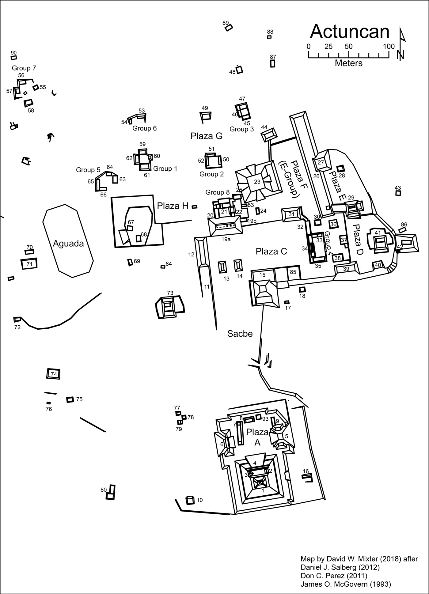
Figure 2. The site of Actuncan (Modified from LeCount et al. Reference LeCount, Christian Wells, Jamison and Mixter2016:Figure 2).
Historical Development
Evidence for the earliest occupation is found on the eastern edge of Actuncan. Deep excavations under Structure 41 revealed six plaza floors, the earliest of which is burnt marl. On this floor, a dedicatory deposit was found consisting of fragments of a Cunil-age colander, and a large ceramic jar rim was used as a brazier. Nearby, three courses of uncut limestone blocks with soft marl mortar may have been the foundation for an early platform. Another similar foundational cache was found under the E-group. As of yet, no domestic structures have been found that date to this time nor to the Middle Preclassic period, although Jenny Creek materials consistently occur in the fill of later structures. The earliest evidence of house platforms comes from three Late Preclassic structures under Group 1. One was faced with a single course of colored stones and large artifacts and filled with yellow clay, whereas the other two were composed of cobble fill overlain with marl surfaces (Rothenberg Reference Rothenberg, LeCount and Blitz2012). Late Preclassic civic constructions have been found underneath the ballcourt and Structures 19 and 34. By far, the largest Late Preclassic civic construction was the triadic complex in Plaza A (McGovern Reference McGovern2004).
In the Terminal Preclassic period, civic buildings were substantially enlarged during Actuncan's rise to prominence. Hallmarks of Preclassic kingship include the addition of red-painted stucco masks to the front of Structure 5 of the triadic group, the building of a ballcourt and the erection of a carved stela in Plaza A (cf. Estrada-Belli Reference Estrada-Belli2011). Structure 19, the largest and most centrally located range structure, sat prominently at the north end of the sacbe facing the triadic complex and the ballcourt. It likely functioned as the locus of kingly administrative practices, whereas the triadic complex served as the ritual center (Mixter Reference Mixter2016). Geochemical residues on the Preclassic summit of Structure 19 document continuously distributed, high-phosphorous signatures indicative of feasting and cooking (LeCount et al. Reference LeCount, Christian Wells, Jamison and Mixter2016). Importantly, earlier domestic structures were buried, and new residential units were built over the buried structures. Late Preclassic structures under Group 1 were covered by thick layers of sterile clay fills, above which were built new platforms oriented in a different direction (Figure 3). At Structure 41, a building platform was constructed on top of 2.6 m of earlier plaza floors. The new house was dedicated by sacrificing a child, smashing ceramic artifacts, and scattering human bone in front of the building.

Figure 3. Profile of Structure 61 showing buried floors and structures (Drawing by Kara Fulton).
By the fifth century AD, civic monuments ceased to be built and elite residences were abandoned. Structure 73, an elite house, was ritually terminated (Simova et al. Reference Simova, Mixter and LeCount2015), and Structure 19 fell into disrepair (Mixter et al. Reference Mixter, Jamison and LeCount2013) as Buenavista del Cayo and later Xunantunich solidified control over sites in the region. In the Late Classic period, Structure 19 at Actuncan was renovated, and Group 8 was appended to it to house a noble family, probably vassals to rulers at Xunantunich. As Xunantunich's power began to wane in the ninth century, Actuncan embarked on a new round of civic building and ritual resignification of old monuments (Mixter Reference Mixter2017; Simova et al. Reference Simova, Mixter and LeCount2015), but the center did not hold. Populations gradually dispersed in the Postclassic period sometime after AD 1000.
Residential Units
The Actuncan Archaeological Project has excavated all residential units visible on the ground surface: six commoner patio-focused groups (Groups 1, 2, 3, 5, 6, 7), three elite houses (Structures 29, 41, 73), and the palace complex (Structure 19 and Group 8). Axial trenching revealed construction stages that were dated by correlating diagnostic ceramic artifacts and radiocarbon dates (Figure 4).

Figure 4. Occupation histories of residential units at Actuncan.
The three elite houses at Actuncan (Structures 29, 41, and 73) are Type VI “sites” in the Xunantunich Settlement Survey (XSS) typology (Yaeger Reference Yaeger, LeCount and Yaeger2010:Table II.4). These residential units are characterized by a large pyramidal substructure greater than 2 m in height surrounded by low terraces and, in some cases, other mounds. During the Terminal Preclassic period, substructures supported limestone-block masonry summit superstructures, all of which display facades with apron moldings covered in stucco and painted red. Given that no Preclassic palace or tombs have been found, early leadership may have been corporately organized, with authority rotating across elite houses. It was not until the Late Classic period that Structure 19 was modified to house nobility and serve as the seat of administrative activities.
Actuncan's commoner settlement is located at the north end of the site and consists of six orthogonally or informally arranged patio-focused groups and seven low platforms corresponding to XSS Types I, II, and III. In the Terminal Preclassic period, platforms were faced with cut-limestone blocks, which, after renovations, were built with river cobbles in the Terminal Classic period. These platforms supported perishable superstructures made of waddle and daub, and in some cases, stone piers acted as foundations for perishable buildings. Over time, household modifications created large residential groups made up of the remains of earlier platforms, perishable superstructures, and residues of domestic activities.
Urban Settlement Patterns
At the founding of the Terminal Preclassic center, both elite and commoner residential units were built surrounding the civic core. The oldest commoner residential units (Groups 1, 5, and 7) were strategically positioned near the aguada. Groups 1 and 5 were less than 100 m from Structure 19, the central range structure. At Group 1, stone-lined crypts (Burials 1 and 4) contained highly decorated pottery including two Aguacate Orange vessels (a Z-angled tetrapod dish and an “Old God” effigy chocolate pot) and a polished parrot effigy lid (LeCount Reference LeCount2010). Crypt burials have not been found elsewhere, although similarly decorated pottery can be found at the other Preclassic patio groups. These data suggest that Group 1 served as the house of a leading family, possibly an early form of ah cuch cab, and other commoner families prospered.
In the Classic period, Groups 2, 3, and 6 were established to the north and east of founding commoner residential units. These groups were smaller and diverged in important ways from their long-established neighbors (Mixter et al. Reference Mixter, Fulton, Bussiere and LeCount2014). Group 1 maintained its privileged status, as indicated by the fact that its eastern structure served as a focal point for sequential burials, but later burials were interred in poorly defined pits and most lacked grave goods (Freiwald Reference Freiwald2015). Terminal Classic architectural modifications were limited and crudely executed using large river cobbles, rather than cut-limestone blocks for platform facades. In contrast, Group 5, a neighbor of Group 1, expanded continuously throughout the Classic period, and its architecture displays some of the best-dressed stonework at Actuncan. Group 7 grew haphazardly around a wide patio, indicating that its structures were either distinctly different in function or were the homes of incongruent social entities. Group 6 may have functioned as a Late Classic special-function building (Fulton Reference Fulton2015). Unlike other nearby patio-focused groups, it was constructed predominantly of perishable materials, and little plaster was found on platform floors. Artifacts associated with domestic activities such as food preparation or lithic production were sparse, whereas there was a higher than expected amount of ritual items. Further, soil chemistry of the area off the platforms found elevated concentrations of elements associated with the use of ochre and hematite.
Elite houses at Actuncan experienced more profound boom-and-bust cycles of growth, collapse, and reorganization than commoner residential units. Structures 29 and 41 are located on the eastern edge of the site adjacent to the E-group, while Structure 73 is located near the sacbe that connects the two parts of the site. After their founding in the Terminal Preclassic period, all underwent construction hiatuses around AD 400. Following the termination of Structure 73, it served as a location of rituals involving periodic interments, the making and scattering of spear points, and feasting well into the Terminal Classic period (Simova Reference Simova and LeCount2015). Structure 29 was not renovated until the Terminal Classic period, when a large and impressive staircase was added to the south side. Structure 41 was remodeled both in the Late and Terminal Classic periods, but later buildings were made of perishable materials and the substructure was covered in stuccoed river cobbles, rather than cut-limestone blocks.
In sum, a small cluster of residential units was arranged in an orderly fashion around Plaza C in the northern civic center at the founding of the Terminal Preclassic center. Commoners lived near the aguada and the elites in sacred locations. All residents lived relatively equidistant from Structure 19, a location where the king would have been accessible to community members during ceremonies. These spatial arrangements are indicative of relatively close community ties and equitable access to public goods and services. This pattern breaks down in the Classic period. Walls were built blocking access to the E-group and Plaza C, and a noble palace compound was constructed by enclosing the north side of Structure 19 with a patio group. Although more residences were built, commoners lived in distinctly different ways from each other as indicated by architectural embellishments and burial patterns. Elites, in contrast, either left the site or lived in much less luxurious houses. Breaks in the social bonds between groups likely began during a collapse of political power in the Early Classic period and continued into the Late Classic period when the site was subordinate to centers in the region.
The Actuncan Archaeogeophysical Program
The description of Actuncan's built environment in the previous section does not take into account houses and features that are buried by urban renewal projects or natural processes. Low constructions in settlement zones can be completely buried by natural processes in upland tropical environments where soil layers are deep (Johnston Reference Johnston2002). Particularly vulnerable to burial are agricultural terraces, water-management features, and boundary markers that play an important role in reconstructing land tenure systems. To more accurately reconstruct the historical development of Actuncan's settlement, we conducted an archaeo-geophysical survey and ground-truthing program in the commoner settlement zone and adjacent Plaza H where buried structures were most likely to occur. No attempt was made to survey the elite residential units, given their placement on deep plaza fills and plaster floors that confound remote-sensing signals.
Two archaeo-geophysical techniques were used: a gradiometer and ground-penetrating radar (GPR). Unfortunately, the GPR survey did not yield valid results, but the gradiometer survey produced an interpretable map. A gradiometer survey is a non-intrusive technique that measures slight variations in the magnetic properties of soil. It results in a magnetic gradient map that displays localized variations in the magnetic field caused by natural and cultural disturbances. Natural soils disturbed by humans digging and filling features, such as trenches and pits, are measurably different in magnetic strength compared to those that have not been disturbed. Magnetic gradients also derive from thermal activities and weakly magnetized objects, such as hearths, kilns, and daub. The size, shape, strength, and magnetic character of disturbances are the basis for describing anomaly signatures.
In regions that have benefited from extensive archaeo-geophysical surveys, consistently patterned anomaly signatures have been correlated to cultural features with a high degree of probability (Gaffney Reference Gaffney2008; Kvamme Reference Kvamme and Johnson2006). Interpretive reliability is established through ground-truthing excavation programs that systematically test anomaly patterns. Remote sensing in the Maya lowlands, however, is still in an exploratory stage. Surveys have yielded mixed results due to water-logged soils, dense forests, and complex site stratigraphy that impede or confound remote-sensing signals (Cap Reference Cap2015; Halperin Reference Halperin2007; Sweely Reference Sweely2005).
In the next section we present the results of the gradiometer survey and ground-truthing. Our primary objective is to identify anomaly patterns that can be correlated with architectural features, particularly domestic platforms. We then reconstruct the historical develop of Actuncan's commoner urban settlement patterns by combining remote-sensing results and excavation data described earlier. These data are used to test correlates of land tenure systems described in the previous section.
The Actuncan Gradiometer Survey
Walker (Reference Walker, LeCount and Blitz2012) surveyed a total of 60,621 m2 (6.06 ha) of land—48,246 m2 in the Northern Settlement Zone and 12,375 m2 in Plaza H—by carrying a Bartington 601–2 Fluxgate Gradiometer along a 1 m traverse interval. Survey results were imposed over a GIS-generated map of the site, thus locating the finds with high precision. The two adjoining areas encompass a large survey block, although a narrow strip of land near the center of the block was not surveyed because it contains a wire fence separating the Juan and Galvez properties. Groups 1 and 2 straddle the fence line and therefore were not completely surveyed, but Groups 3, 5, 6, and 7 and Structures 48, 49, 87, 88, 89, and 90 were completely mapped.
The gradiometer data were collected using grids measuring 20 x 20 m established on the cardinal directions. This method requires the instrument to be programmed to collect a set number of readings over a number of traverses. The pace of the surveyor or the rate at which the instrument records the data is set to match the survey parameters. This results in a regularized or gridded dataset with no need for additional data interpolation before data processing. The gradiometer data were processed to lessen the effects of background noise and to enhance the quality of the signal (target) in the geophysical data. A destripping zero median filter was run to balance the two sensors, and minor destaggering was performed where needed. Data were exported from Archaeosurveyor 2.0 as a geo-referenced raster file into ArcGIS for analysis. All images are geo-referenced to the site grid, established and maintained by coordinates obtained using a total station.
Survey Results
The magnetic gradient of the Actuncan site is quite low (+/− 7 nT with spikes from ferrous material removed). For visualization and analytic purposes, the data were clipped to =/− 3 nT (Figure 5). Overall, the data are good, but noisy in places where the soil is thinner.

Figure 5. Magnetic gradient map of the Northern Settlement Zone and Plaza H.
Two consistent anomaly signatures are recognizable in the magnetic gradient map of Actuncan. Most obvious are areas of enhanced magnetism associated with patio-focused groups visible on the ground surface today (Figure 6a). From our excavations, we know that these groups are palimpsests of building and living activities. Stone-faced platforms were cut into the natural clay and filled with limestone fragments, river cobbles, and trash stabilized by internal retaining walls. All these materials make the magnetic susceptibility of platforms strikingly different from that of undisturbed clay. As domestic houses, they also contain numerous cut-and-fill pits, burnt features, and magnetized objects that, combined with platforms, create a complex cluster of magnetic gradients and shapes. We postulate that areas of enhanced magnetism associated with Structures 48 and 88 are the signatures of residential units that are almost completely buried. A second magnetic pattern is the many large, isolated rectangular patterns formed by linear dipoles with weak magnetic centers (Figure 6b and c). We postulate that these anomalies are signatures of nondomestic constructions. When tested, they should lack multistage constructions and features that give patio-focused groups their enhanced magnetism. The vast majority of signatures are complex dipoles and amorphously shaped anomalies found scattered across the survey area. Due to their inconsistent patterning, they likely represent a wide array of smaller cultural and natural features. Our ground-truthing program aimed to confirm these hypotheses.

Figure 6. Overlays of Malerized architectural renderings on magnetic anomalies: (a) area of enhanced magnetism associated with Group 7; (b) positive rectangular pattern with weak magnetic center near Group 7; (c) linear dipoles abutting Structure 90.
Ground-Truthing Results
Sixteen magnetic signatures and two areas with normal magnetism were tested using 20 1 x 1 or 1 x 2 m testpits (Supplemental Figures 1 and 2; Supplemental Table 1). Testpits (Units 14F, H, and J) within two areas of enhanced magnetism revealed a nondomestic platform with abundant lithic debris 6 m from Structure 88 (Supplemental Figure 3) and a domestic platform 4 m from Structure 48. We suggest that the domestic platform is part of the buried remains of a patio group, whereas the platform near Structure 88 may have been a special-use workspace. Both are located on the eastern edge of the survey near the ridgetop overlooking the valley. In the same area, testpits (Units 14 G and I) sampling linear dipoles revealed a multistage perishable structure that has evidence of the production of red pigment (Supplemental Figure 4) and a low, multistage domestic platform near Structure 49. Testpits (Units 14C, K, L, and M) sampling positive rectangular patterns with weak magnetic centers on the western side of the settlement zone yielded evidence of ditch and bank features associated with an agricultural field system (Supplemental Figure 5). Unit 14N tested a linear dipole signature running parallel to Structure 90 and a possible buried structure. Excavations revealed a terrace wall made of large cut-limestone blocks covered in plaster tilting 40o with the slope. After these discoveries, agricultural features were targeted for more intensive excavations, the results of which are discussed later.
As predicted, amorphous signatures were less reliable indicators of cultural features in the Northern Settlement Zone. Units 14A, B, D, and O revealed diverse archaeological remains including cut-and-fill activities and burnt features. Plaza H testpits also produced variable results as expected. Units sampling linear dipoles and rectangular anomalies discovered plaza floors and fills, collapsed walls, and clusters of river cobbles, none of which appear to be domestic structures. Most of the constructions rest on plaza floors and were not cut into sterile clay, making the anomaly signatures difficult to interpret. Finally, control units discovered nothing that would be predicted to create an anomaly.
To better understand the nature of the field systems discovered in the ground-truthing program, Theresa Heindel (Reference Heindel, LeCount and Mixter2017, Reference Heindel, Mixter and LeCount2018) excavated buried and visible stone terraces on the eastern slopes of the aguada drainage. She partially uncovered two field systems and a special-use construction associated with Structure 90. Field System 1 is located near the bottom of the drainage and Field System 2 near the top (Figure 7). In this location, the fields lie within an interstitial area formed by Groups 5, 6, and 7. The special-use structure is north of Group 7 overlooking Requena Creek.

Figure 7. Overlay of agricultural field systems on magnetic gradient map (Map by David W. Mixter).
Field System 1 is an interconnected group of stone alignments that formed agricultural plots and a low platform (Supplemental Figure 6). These features were uncovered in shallow excavations across 52.5 m2. Low walls (< 40 cm) varied between one and four courses high and were constructed using river cobbles and irregular limestone blocks. The plots are small; the largest is 3.5 x 5 m in size. Similar dry-field systems of contiguous plots have been found in the Petexbatún Region of Guatemala and elsewhere (Dunning and Beach Reference Dunning and Beach1994). At Actuncan, plots were enriched and the slope stabilized by discarded trash that dates to the Late and Terminal Classic periods. At the northeast corner of the system, a small channel of redeposited white clay leads to the ditch and bank found in Unit 14K less than 3 m away. A small platform, 2 x 2 m in size, is embedded in the field system. The platform fill contains packed river cobbles similar to that for house platforms, but it was probably not a residence because it was not raised above the level of the plots. It might have been a champa (fieldhouse) for people tending the fields.
System 2 was uncovered in a 31 m2 excavation block and consists of at least eight low wall segments forming plots measuring 2 x 3 m in size (Supplemental Figure 7). Another small rectangular platform (2 x 3.5 m) was found in the middle of the system, as well as two pit features that are 70 cm deep, circular, and bounded by rocks. They contained large pottery sherds and charcoal at the bottom, but not throughout the matrix. Like System 1, abundant trash was found strewn across the plots, illustrating the intensive nature of in-field agriculture.
The special-use construction comprises a small building (Structure 90) with two terrace walls located 2 m upslope, paralleling the topography. The two walls are short, no taller than 30 cm, and are separated by a 20 cm wide channel with a plastered floor. Jute and marine shell were recovered from the lowest occupation surface, and seven human teeth, nine shell beads, and a posthole were found above a burnt surface near the top of the walls. Given the unusual nature of these features and artifacts, this construction might have served as a well house or water shrine similar to that discovered at the nearby settlement of Chan (Wyatt Reference Wyatt2008).
In sum, the archaeo-geophysical program achieved its primary objective of identifying magnetic signatures that correlate with buried features in the Northern Settlement Zone, although much more work is required to confidently interpret magnetic signatures. According to Walker, the success of the gradiometer survey is due to the presence of shallow conductive soils at the site. Actuncan's soils are members of the Piedegral Series of the Yaxa Suite found on the Early Tertiary limestones that form the rolling hills of western Belize, north of the Belize River (Birchall and Jenkins Reference Birchall and Jenkins1979:34–35). The main soils derive from dark-colored blocky clays that are neutral or alkaline and well supplied with calcium and magnesium, but have only moderate amounts of other nutrients such as iron. Constructions and features cut into the clayey soils and filled with stone and anthropogenic materials produce visible magnetic gradient differences. In the Northern Settlement Zone, no plaza surfaces capped domestic deposits, but instead, occupation surfaces were cut into the sterile soil. Further, the survey was conducted at the end of the dry season when the soil was evenly dry and differential moisture was not a factor in data recovery. Finally, Walker mapped a relatively flat pasture that was burnt or chopped to the ground before the survey. This preparation allowed for a rapid and evenly paced gradiometer survey that resulted in high sample density and good resolution.
Spatial Analysis of Residential Units and Buried Signatures
To determine the spatial distribution of residential units in Actuncan's Northern Settlement Zone and how it changed through time, we used ArcGIS average nearest neighbor analysis (NNA). Points were placed in the center of residential units for analysis, and each residential unit was assigned an occupational time span: Preclassic (Groups 1, 5, and 7 and Structure 48) and Classic periods (Groups 1, 2, 3, 5, 6, and 7 and Structures 48 and 49).
The distribution of residential units was dispersed in both time periods with nearly identical measures of standard deviation (Preclassic Z-score = 5.12 and Classic Z-score = 4.34) and significant p-values (both p < 0.001). These data indicate that there was less than a 1% likelihood that the patterns could be the result of random chance. Although the observed mean distance between residential units declined from 105 to 62 m over time, this decrease was due to the addition of buried domestic platforms on the eastern side of the settlement zone that created firm boundaries for the statistic. Nonetheless, residential units did not cluster. Although houselots became smaller through time, their spatial relationships with neighbors remained constant.
To investigate the exclusionary nature of property, we used the anomaly signature of rectangular patterns to look for evidence of houselot improvements. Structural cores of houselots are identified as areas of enhanced magnetism in Actuncan's gradiometer map, and as documented earlier, large rectangular anomalies correlate with low structures and agricultural features. If community members built walls around their houselots or improved them substantially, they should appear conjoined by anomalies. If not, houselots will appear isolated, separated by empty buffer zones.
To analyze the spatial patterning of anomalies, we used kernel density analysis (KDA) or estimates (KDEs). Wheatley and Gillings (Reference Wheatley and Gillings2002) describe KDEs as similar to simple density estimates, except in KDEs, each point receives a density function, called a “kernel,” which are added together to estimate point densities. Baxter and colleagues (Reference Baxter, Beardah and Wright1997) suggest that KDEs are better at displaying patterning than other methods because they use a symmetrical probability density function to smooth data. Each point's kernel density is represented as a density height, a value based on the point's density in relation to surrounding ones. A contour plot of ranked density data is generated to illustrate gradients of higher and lower densities. KDEs also provide illustrations of asymmetrical point densities better than simple density or cluster analyses, resulting in a robust tool for characterizing multivariate data (Whallon Reference Whallon and Aldenderfer1987). In ArcGIS 10.2, KDEs are available in the form of KDA.
Using Actuncan's data, KDA was used to produce an anomaly densities map of rectangular anomalies with weak magnetic centers. Nelson identified them based on patterning in linear dipoles and marked them as polygons on the magnetic gradient map. One data point was placed in the center of the rectangle to represent the anomaly. The KDA function was performed at a search radius of 20 m that produced a smoothed floating-point raster grid of localized density estimates (Figure 8).

Figure 8. Kernel density estimates, rectangular magnetic signatures, and visible architecture in the Northern Settlement Zone.
Unsurprisingly, kernel densities are greatest within the structural cores of patio-focused groups (Groups 6 and 7), whereas Group 3 and isolated structures (48, 49, 87, 88, and 89) display moderate densities. More intriguingly, the kernel density data illustrate interconnectivity between neighbors. When buried features are taken into consideration, the Northern Settlement Zone appears as a web of constructions, rather than spatially buffered houselots. In the eastern portion of the settlement, residential units and buried buildings form dense clusters of constructions in which small domestic units are surrounded by low platforms or perishable buildings erected on clay floors, some of which have been shown to be locations of specialized craft activities, including lithic and pigment production. On the western side of the settlement, Groups 1, 6, and 7, and probably 5, are interconnected by agricultural features and low constructions such as those found in ground-truth excavations. None of the stone walls that have been found through ground-truthing appear to be high enough to restrict access to fields.
Anomalies were dated based on recovered diagnostic ceramic artifacts. The low platforms on the eastern side of the settlement date to the Late Classic, although diagnostic artifacts are scarce. The field system was certainly in use in the Terminal Classic period, when people fortified the soil with trash dating to this period. Other agricultural features contain only Late Classic diagnostics, indicating that improvements began earlier.
Conclusions
Our combined excavation and remote-sensing data support the proposition that a common property regime was established at Actuncan in the Terminal Preclassic period and persisted until the site was abandoned sometime after the Terminal Classic period. These interpretations are based on four archaeological correlates of common property regimes: (1) diachronic changes in community settlement patterns, (2) spatial proximity of residential units to land and resources, (3) the arrangement of land subdivision and improvements, and (4) the presence of public goods in community land.
At the founding of the political center, a small number of elite and common families built new homes on top of an earlier settlement around the civic core of the site. Commoners settled in the Northern Settlement Zone near the aguada, an important public good for agriculturalists, whereas elites built houses on the eastern and southern edges of the civic zone. Over time, founding families improved their houselots with ephemeral outbuildings and features, and new commoner residential units were built on the eastern edge of the Northern Settlement Zone. These new residential units did not infringe on founding patio-focused lands. There is no evidence that commoner houselots were subdivided, although their boundaries became more delineated in the Late Classic period when additional residential units were built on the eastern side of the settlement. Common land above the aguada drainage was improved. Excavations in this area discovered two in-field systems of walled plots and champas interspersed between Groups 5 and 7, whereas anomaly signatures surrounding residential cores of houselots indicate additional improvements. Most of these signatures date to the Late and Terminal Classic periods, which lends evidence to suggest that rights to land within the urban settlement became inherited social entitlements at that time. The Northern Settlement Zone also contains two special-use facilities, a water shrine or well house and Group 6, a set of two platforms that supported perishable buildings and contained an unusual sample of artifacts. In sum, all four archaeological correlates for common property have been confirmed for Actuncan's Northern Settlement Zone.
Although day-to-day oversight of Actuncan's common land resided in the households that lived and worked in the Northern Settlement Zone, we suggest that collective action between governing elites and commoner supporters was a critical factor for the initial implementation of the land tenure regime. Most likely, elites recognized that the site's commoner families were key allies in promoting the newly established center to hinterland populations. This common interest was a possible motivation to negotiate access to public goods and services equitably at the founding of the center. Indeed, all founding residential units were in close proximity to civic monuments, particularly Structure 19, the site's largest range structure, and commoners lived close to the vital aguada. In the Late and Terminal Classic, the noble court at Actuncan or the ruler's court at Xunantunich would have overseen land disputes. We note that evidence for the inheritance of social entitlements to field plots appeared when political power was the most hierarchically organized and tax-tribute demands the most burdensome. It raises questions about linkages between agricultural intensification and changes in property rights.
Although Maya archaeologists have been limited in studying ancient land tenure systems given the lack of textual evidence, our combined excavation and remote-sensing efforts provide new techniques for recovering and analyzing data to address questions about property. The archaeo-geophysical program at Actuncan was successful in discovering buried agricultural systems, low platforms, and other features under tropical soils prone to colluviation on gentle slopes. When buried remains are taken into account, the Northern Settlement Zone appears as a web of residential buildings, informal constructions, and landscape features that demonstrate a far greater degree of social connectivity between houselots than what meets the eye on the ground surface. This densely improved landscape is more in keeping with how modern Maya community members live today than the isolated residential units envisioned by archaeologists who work solely on standing-stone architecture.
Acknowledgments
Major support for the Actuncan Archaeological Project was provided by the National Science Foundation (BCS0923747) and the National Geographic Society (CRE-9279-13 and 9658-15). Two University of Alabama (UA) grants from the College of Arts and Sciences funded the gradiometer survey and ground-truthing projects. The UA Department of Anthropology also provided logistical and financial support. Ongoing investigations at Actuncan take place through the permission and support of the directors of the Belize Institute of Archaeology, especially Drs. John Morris and Jaime Awe. The Galvez and Juan families graciously permitted us to work on their lands, and we appreciate their support of our research. Many people contributed to the success of the gradiometer project and the excavation data presented here, especially David Mixter, Bobbie Simova, Kara Fulton, Carolyn Freiwald, Dan Salberg, Angela Keller, and Jane Millar. Theresa Heindel's work in the Northern Settlement Zone was crucial in solidifying our interpretation of the field systems. We are indebted to the many fine Belizean crew members who make this project successful, especially our foremen Carlos Cocom, Cruz Puuc, and Rene Uck. We also wish to thank Kenneth Kvamme who commented on an earlier version of this article, as well as the anonymous reviewers who provided comments. Scott Hutson, David Carballo, and Christopher Morehart also provided enlightening discussions of Mesoamerican land tenure systems, and we thank them for their time and effort.
Data Availability Statement
All artifacts are curated at Clarissa Falls Eco-resort, Belize. Requests to access the collections and magnetometer data should be sent to Dr. Lisa LeCount, principal investigator of the Actuncan Archaeological Project (AAP). Annual AAP reports are available as downloadable documents at http://llecount.people.ua.edu.
Supplemental Materials
For supplementary material accompanying this paper, visit https://doi.org/10.1017/laq.2019.16.
Supplemental Text 1. Ground-truthing Excavations in Actuncan's Northern Settlement Zone.
Supplemental Table 1. Ground-truthing Results by Provenience.
Supplemental Figure 1. Malerized rendering of Northern Settlement and Plaza H architecture overlain on magnetic gradient map (Illustration by David W. Mixter and Ted C. Nelson).
Supplemental Figure 2. Ground-truth testpit locations overlain on magnetic gradient map (Illustration by David W. Mixter).
Supplemental Figure 3. Late Classic platform in Lot 14J3 (Photograph by Jane Millar).
Supplemental Figure 4. Unit 14I north profile. Pit feature filled with red matrix and charcoal originates at upper floor (Photograph by Jane Millar).
Supplemental Figure 5. Terraformed sterile white clay in Unit 14K (south profile) (Photograph by Jane Millar).
Supplemental Figure 6. Plan view of Field System 1 (Illustration by Theresa Heindel).
Supplemental Figure 7. Plan view of Field System 2 (Illustration by Theresa Heindel).


