


Under normal climate conditions, the northern coast of Peru is a coastal desert, with very little rainfall. Its aridity is caused by the presence of an extensive subtropical area of high atmospheric pressure associated with the semi-permanent southeastern Pacific anticyclone and the cold Humboldt oceanic current from the Antarctic. Together, these ocean-atmosphere features suppress precipitation and instead promote abundant coastal fog (Garreaud et al. Reference Garreaud, Christie, Barichivich and Maldonado2007). However, the normal aridity is cyclically interrupted by torrential summer rainfall during the anomalous climate conditions associated with the El Niño-Southern Oscillation (ENSO; Caviedes Reference Caviedes2001; Diaz and Markgraf Reference Diaz and Markgraf2000; Maasch Reference Maasch, Sandweiss and Quilter2008; Sandweiss et al. Reference Sandweiss, Maasch, Fred T, Andrus, Reitz, Richardson, Riedinger-Whitmore, Rollins, Anderson, Maasch and Sandweiss2007, Reference Sandweiss, Andrus, Kelley, Maasch, Reitz and Roscoe2020). During El Niño-like events, the tropical Pacific region off the coast of Peru warms significantly, and the semi-permanent anticyclone weakens, promoting extensive precipitation. Rainfall affects the middle and lower parts of the coastal valleys, activating dry rivers and ravines in the slopes of the fertile valleys and causing extensive damage to irrigation systems and urban settlements. In addition to the rains, El Niño-like events alter the marine ecosystem, generating a loss of biomass and the proliferation of warm-water fish species (Castro Reference Castro1986; Sandweiss et al. Reference Sandweiss, Maasch, Burger, Richardson, Rollins and Clement2001).
The effects of El Niño-like events in past times have been recorded both geologically and archaeologically. One of them, in particular, is referred to as the El Niño-like event of AD 600 (see Carré et al. Reference Carré, Sachs, Purca, Schauer, Braconnot, Falcón, Julien and Lavallée2014; Christol et al. Reference Christol, Patrice Wuscher, Valentin Mogollón, Gutiérrez and Carré2017; deMenocal Reference deMenocal2001; Goepfert et al. Reference Goepfert, Aurélien Christol, Patrice Wuscher, Lefevre, Mogollón, Geopfert, Vásquez, Clément and Christol2016; Rein et al. Reference Rein, Andreas Lückge, Frank Sirocko and Dullo2005). Some scholars (Moseley and Feldman Reference Moseley and Feldman1982; Nials et al. Reference Nials, Dees, Moseley, Pozorski, Pozorski and Feldman1979a, Reference Nials, Dees, Moseley, Pozorski, Pozorski and Feldman1979b) argue that, in the prehispanic northern coast of Peru, the occurrence of this phenomenon coincided with important social changes. At that time, this region was occupied by one of the most emblematic and best-studied cultures of the Andean world: the Moche culture (ca. AD 100–850; Figure 1).Footnote 1 Nials and collaborators (Reference Nials, Dees, Moseley, Pozorski, Pozorski and Feldman1979a, Reference Nials, Dees, Moseley, Pozorski, Pozorski and Feldman1979b) postulated that the El Niño-like event of AD 600 caused the fall of the Moche state and the abandonment of its capital, the site of Huacas de Moche—also known as Huacas del Sol and de la Luna. Pampa Grande, in the Reque Valley, would have become the subsequent Moche capital. Simultaneously, in the Moche Valley, the site of Galindo would have replaced Huacas de Moche as the most important settlement in the valley. Moseley and Deeds (Reference Moseley, Deeds, Moseley and Day1982) argue instead that, at the end of the sixth century, a huge incursion of sand buried the city of Huacas de Moche and other provincial sites, as well as their agricultural lands, causing their abandonment.
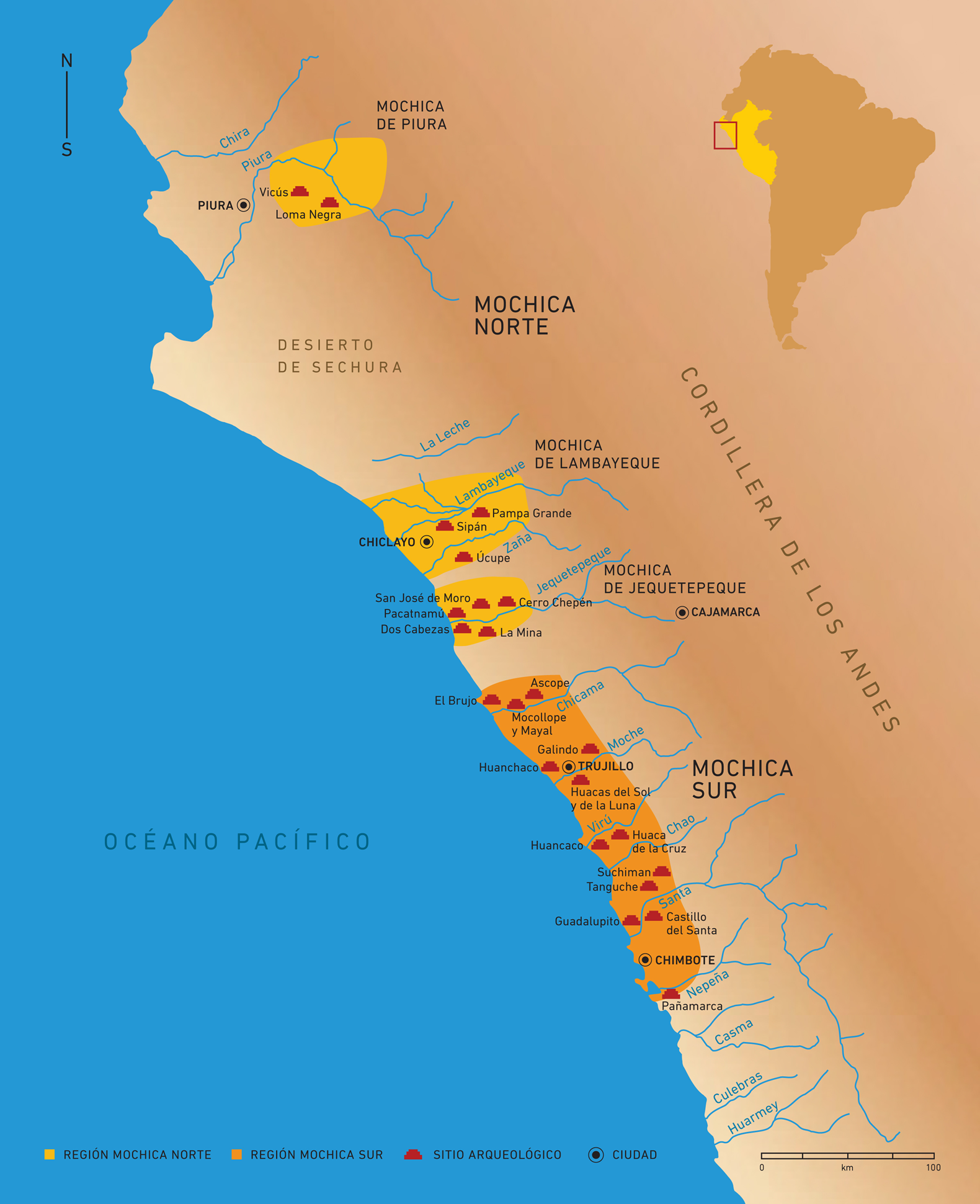
Figure 1. Map of the north coast of Peru indicating the main sites where the Moche culture developed. (Color online)
The investigations of Nials and colleagues (Reference Nials, Dees, Moseley, Pozorski, Pozorski and Feldman1979a, Reference Nials, Dees, Moseley, Pozorski, Pozorski and Feldman1979b), as well as those of Moseley and Feldman (Reference Moseley and Feldman1982), are framed within a model that considered the Moche culture as a monolithic state that was territorially unified within an area extending from the Piura region in the north to the Nepeña Valley in the south,Footnote 2 with Huacas de Moche as its capital (Larco Reference Larco Hoyle2001; Lumbreras Reference Lumbreras1969; Moseley Reference Moseley1992). In the mid-1990s, several researchers (e.g., Castillo and Donnan Reference Castillo, Donnan and Makowski1994; Shimada Reference Shimada, Uceda and Mujica1994) suggested the existence of at least two territorial Moche spheres: Northern Moche and Southern Moche. They were geographically separated by the desert of Paiján and were politically independent yet ideologically bounded. In recent years, the idea of the existence of a Southern Moche state seems to have gained more ground, and the northern area has been reevaluated. There is now a consensus that various complex societies would have configured valley-states or autonomous multivalley-states, bounded by ideology, as in the cases of the valleys of Jequetepeque and Lambayeque (Castillo and Uceda Reference Castillo, Uceda, Silverman and Isbell2008).
Thompson and coauthors (Reference Thompson, Mosley-Thompson, Bolzan and Koci1985) found that in the ice core record of the Quelccaya Mountain, in the Cuzco region, heavy rainfall events were followed by about 30-year droughts during the sixth and seventh centuries AD (see also Shimada et al. Reference Shimada Izumi, Thompson and Mosley-Thompson1991a). Similar climatic extremes were found by Abbott and coauthors (Reference Abbott, Binford, Brenner and Kelts1997) in sediment cores from Lake Titicaca. Climate relations between regions have been useful in identifying how the climate behavior in one area affects others (see Bird et al. [Reference Bird, Abbott, Mathias Vuille, Rodbell, Stansell and Rosenmeier2011] for Pumacocha Lake and Conroy et al. [Reference Conroy, Jonathan Overpeck, Shanahan and Steinitz-Kannan2008] for data from El Junco Crater Lake in the Galápagos Islands). The results from the ice core record, however, only reflect the history of precipitation in a particular mountain (Calaway Reference Calaway2005) and should not lead to generalizations regarding a larger region. The development of local in situ proxies (e.g., biogeography) helps better pinpoint climatic changes in the Peruvian coast (Goodbred et al. Reference Goodbred, Tom Dillehay and Sawakuchi2020; Sandweiss et al. Reference Sandweiss, Andrus, Kelley, Maasch, Reitz and Roscoe2020). Indeed, the coastal-based examination of past ENSOs provided by Sandweiss and coauthors has led to the identification of “flavors”—a term used by the authors—that better characterize ENSOs’ variability in coastal settings (see Sandweiss et al. [Reference Sandweiss, Andrus, Kelley, Maasch, Reitz and Roscoe2020] for a detailed characterization of flavors and proxies). Regional and local studies have thoroughly documented El Niño-like events of AD 600 in the Andean region.
The environmental stress caused by the extended aridity (or large amounts of rain) during this extreme El Niño-like event would have affected the agricultural production of the northern coastal territories and “was at least partially responsible for aspects of the Mochica IV–V societal reorganization, particularly the population nucleation at valley necks with easy access to water and control of the principal intakes for the valley-wide irrigation canals” (Shimada et al. Reference Shimada Izumi, Thompson and Mosley-Thompson1991a:265). Shimada (Reference Shimada, Uceda and Mujica1994) proposed that this extreme climate event would have caused the abandonment of settlements and agricultural lands located in the lower part of the Moche Valley, such as the city of Huacas de Moche, the old Moche capital. The Mochicas would have moved to different places in the northern part of the valley, occupying highly nuclearized settlements, such as Galindo, in the neck of the valley. At a regional level, Pampa Grande in the Lambayeque Valley would have become the new Moche political and religious center.
Moseley (Reference Moseley1997:59), discussing the proposal of Shimada and coauthors (Reference Shimada Izumi, Thompson and Mosley-Thompson1991b), suggested “additional change agents” that he defined as convergent catastrophes: “crises produced by two or more collateral natural catastrophes.” In the Jequetepeque Valley, at the site of Dos Cabezas, researchers identified evidence of an environmental catastrophe that occurred during the seventh century, which began with a severe period of rainfall and flooding during an El Niño-like event that destroyed the urban settlement and farmlands of the valley. By synergy, this event was followed by a massive entry of wind-driven sand from the coast, which buried the settlement and led to its abandonment (Moseley and Deeds Reference Moseley, Deeds, Moseley and Day1982). In the Alto Piura, evidence of an El Niño-like event was recorded and dated to about AD 550–600. According to Kaulicke (Reference Kaulicke, Uceda and Mujica1994), this event preceded a notable decrease in occupation of the area. After it, there was no clear evidence of the Moche presence, which suggests the abandonment of Moche sites in the region. Thus, the hypothesis for the abandonment of Moche sites seems to be confirmed in the Jequetepeque Valley and in the Alto Piura region.
This article, however, does not focus on the collapse of complex societies (Bawden Reference Bawden, Railey and Reycraft2008; Chapdelaine Reference Chapdelaine, Bawden and Reycraft2000) but instead on the consequences of climatic alterations. Recent archaeological studies on neighboring regions and earlier periods have posited that heavy rainfall events can drastically affect the livelihoods of coastal communities (Mauricio Reference Mauricio2018; Nesbitt Reference Nesbitt2016; see also Prieto et al. [Reference Prieto, Verano, Goepfert, Kennett, Quilter, LeBlanc, Fehren-Schmitz, Forst, Lund, Dement, Dufour, Tombret, Calmon, Gadison and Tschinkel2019] for a later period). At Huacas de Moche, researchers have used two types of evidence to support their model: (1) a layer of clay and hard silt that covers most of the urban area between the two huacas, interpreted as evidence of an alluvium that hit the city around AD 600; and (2) layers of sand covering the structures, excavated in the 1970s by the Chan Chan-Moche Valley Project (Topic Reference Topic1977), and interpreted as post-El Niño-like events. Our investigations at the site lead to a different interpretation of the same evidence, which in turn, calls for a reexamination of the sociopolitical consequences typically related to El Niño-like events.
The Site of Huacas de Moche
Huacas de Moche is located south of the Moche River in the middle part of the valley of the same name. It is surrounded by the Cerro Negro to the north, Cerro Blanco to the east, rural constructions in the Moche countryside to the west and southwest, and barren lands to the southeast. In this part of the valley, climate conditions are dry, and the annual rainfall does not exceed 40 mm in typical years (BWh in the Köppen climate classification). The Moche River, in its east–west route toward the Pacific Ocean, passes through the northern side of this prehispanic settlement, about 170 m away, separated by the Cerro Negro, which constitutes a natural barrier between the river and the settlement. Then, the river changes its direction slightly toward the southwest, about 280 m to the west of Huaca del Sol. Following the direction of the river toward the sea, Huacas de Moche is located approximately 6 km off the coast.
The area of study sits predominantly in a coastal plain, on the border of the last fluvial-alluvial terrace, and it is occupied by farmlands and houses in the Moche countryside. The occupied plain encompasses approximately 40 ha and has been formed from the deposition of sand carried by winds that blow mostly in a south–north direction. This flatland, however, was modified by human occupation, which generated a stratigraphy in which sand is mixed with earth architecture and a variety of cultural elements (ceramics, metal objects, stones and stone objects, bones, and shell remains). This Moche settlement occupied the lower and middle part of the western slope of Cerro Blanco. At its peak there were 75–100 ha of occupied area (see also Uceda Reference Uceda, Quilter and Castillo2010a; Uceda and Canziani Reference Uceda, Canziani, Macharé and Ortlieb1993; Uceda et al. Reference Uceda, Morales and Rengifo2016, Reference Uceda, Morales and Rengifo2018).
Throughout the Moche period, the city was built entirely of mud: mudbricks (adobes) were the structural base of the residences, palaces, and temples. The site includes three main architectural components: (1) the ceremonial complex known as Huaca de la Luna, including the Old Temple and the New Temple (Figure 2); (2) Huaca del Sol, a building that was an elite residence until it became a palace; and (3) the urban center, where residences and workshops were located, connected by streets and alleys (Figure 3).
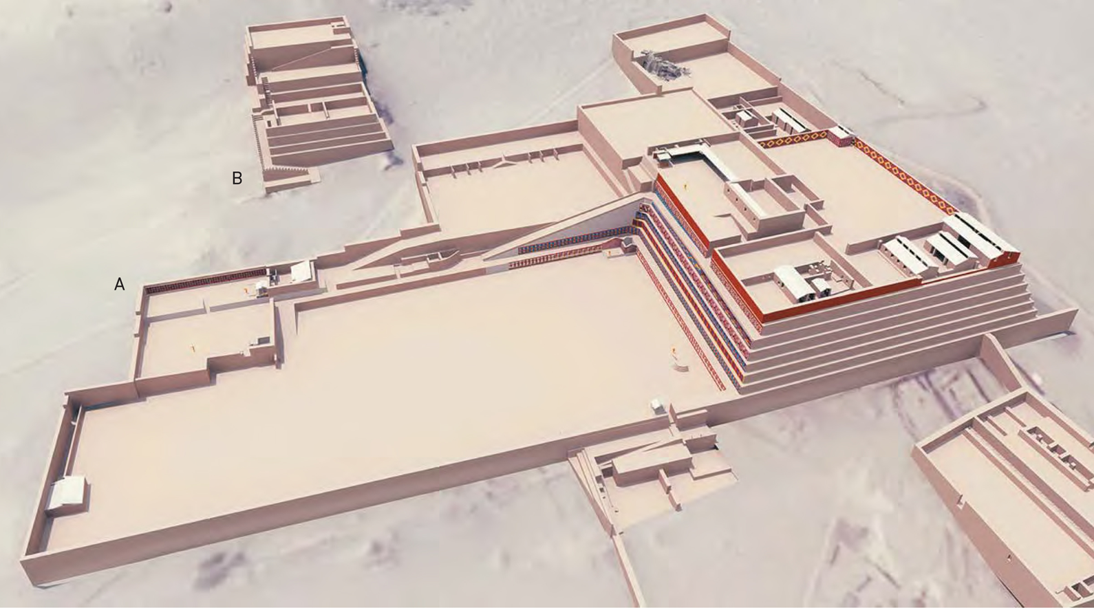
Figure 2. Isometric reconstruction of the (a) Old Temple and the (b) New Temple of Huaca de la Luna.
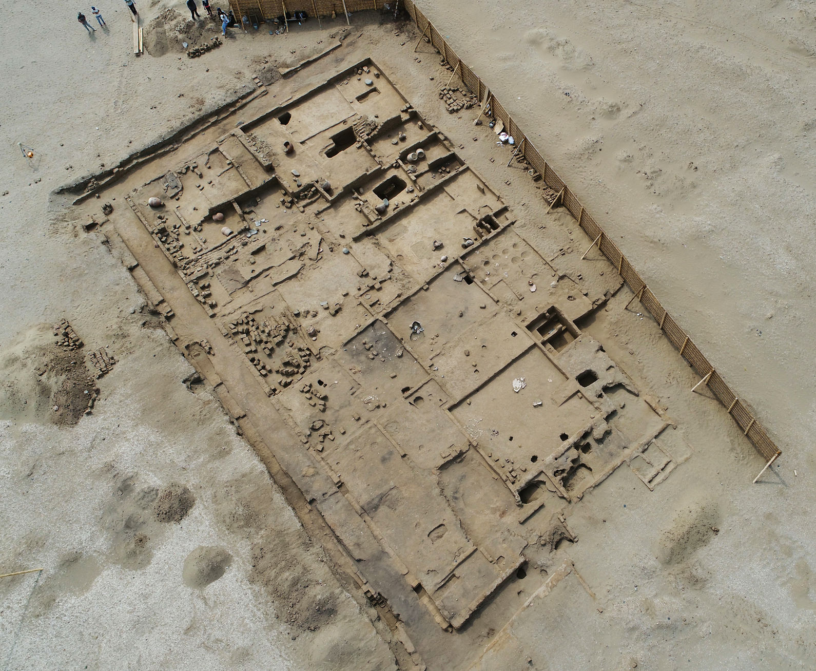
Figure 3. Remains of architectural compounds found at the urban center of Huacas de Moche (photo: Luis Jaime Castillo).
The Old Temple occupies the plain and the lower part of the west slope of Cerro Blanco. It is a succession of five superimposed edifices. After years of archaeological work in this building, it is now known that, after certain intervals of time, the Mochicas buried their temple with adobes, creating a new platform on which a new edifice was built (see Uceda and Canziani Reference Uceda, Canziani, Uceda, Mujica and Morales1998; Uceda and Tufinio Reference Uceda and Tufinio2003). The New Temple, located on the same western slope of Cerro Blanco, is a succession of two superposed buildings constructed immediately to the east of the Old Temple (Uceda et al. Reference Uceda, Tufinio and Mujica2011a, Reference Uceda, Tufinio and Mujica2011b).
Studies of the architectural and occupational sequence at Huaca de la Luna, as well as excavations in the urban center, have provided valuable information about the history of the site (Uceda Reference Uceda, Quilter and Castillo2010a). Thanks to three decades of research (Uceda et al. Reference Uceda, Morales and Rengifo2016, Reference Uceda, Morales and Rengifo2018), it is known that the site had a long occupational history that started four centuries before the Common Era and continued until the beginning of the Spanish conquest in 1532 (Supplemental Figure 1). In that long history, the Moche occupation was the longest and most resilient in the region. A previous occupation associated with the Salinar culture seems to have been limited to certain sectors on the west side of Cerro Blanco and is estimated to have lasted from about 401 BC to AD 91 according to two radiocarbon dates.Footnote 3 Late occupations associated with the Chimu and Inca cultures were short and of small scope.
Evidence of Heavy Rainfall Events
This section discusses two types of evidence of heavy rainfall events that have been recorded by recent archaeological work at Huacas de Moche: (1) the erosion generated by rains, which left little consistent sediments corresponding to water streams on exposed surfaces and on architectural structures (in the latter case, these traces can be observed in the plastering of ceilings and walls); and (2) the accumulation of sediments when rainwater got stuck and formed pools in closed spaces, such as patios or plazas. The latter case led to the formation of fine laminar-type sediments composed mainly of sand, silt, and clay.
During an El Niño-like event, the lower part of the valley suffers the overflow of the river and, with it, erosion of the terrain caused by the strong movement of alluvial sediments. It is only when the floods end—when the river loses its carrying force—that it leaves behind deposits composed of diverse thick residues. The absence of pebbles and gravels in the strata recorded at Huacas de Moche distinguishes such deposits from those produced by the passing of major floods.
At Huacas de Moche, a compact layer has been recorded in several sectors, especially in the central zone of the urban center, just between the two huacas. This hard deposit has been recorded directly below the modern surficial layer, and its thickness ranges between 20 cm and 50 cm. The stratum's composition is homogeneous across the central area of the urban center, consisting essentially of fine sand, silt, and clay. In the northern end of the site, this compact layer was less affected, and one can still observe furrows associated with the Chimu irrigation canals. In contrast, in the southern sector of the city, this hard layer does not exist—explanations for its absence are that the area was affected by subsequent erosions (post-Moche or modern El Niño-like events, overflows of irrigation canals during the Chimu period, and so on) or that no farming work has been done in this sector.
Our excavations revealed that, in the central area of the urban center, Moche architectural features were severely damaged by post-Moche agricultural activities. There is evidence of dismantled adobe walls: in most cases, only their prints and foundations remain. More to the point, Chimu canals have been archaeologically recorded and associated with the upper layers of the area and breaking Moche compound's walls. In this regard, Kus's work (Reference Kus1980) emphasizes evidence of farming lands in front of Huaca de la Luna and Huaca del Sol. Therefore, to farm in this sector of the city, architecture had to be dismantled, so that the terrain could be plowed and irrigated. Erosion due to these farming activities caused strong compaction when the land was abandoned (Butzer Reference Butzer1989:127), probably during colonial times.
Additionally, excavations on the northern side of the site (Chapdelaine et al. Reference Chapdelaine, Bernier, Pimentel, Uceda, Mujica and Morales2004:185) revealed a Chimu administrative compound, based on its wide stone walls, spacious rooms, and Chimu elite pottery. Furthermore, a Chimu temple was built at the top of Cerro Blanco (Bourget Reference Bourget, Uceda, Mujica and Morales1997). This evidence suggests that the Chimu modified the ancient Moche city for both ritual and agricultural purposes. Hence, the aforementioned hard sediment resulted from destruction of the urban center's residences, which was related to the slow transformation and reuse of these lands as agricultural fields.
Below this compact stratum are layers of sand that correspond to post-El Niño-like periods. Such deposits resulted from the activity of trade winds that transport sediment from the sea (Morales Reference Morales2007:256, 271). In excavated areas where these layers of sand are found immediately below the modern surface layer, there is no evidence of the hard compact stratum. Therefore, these sediments of sand were deposited prior to the destruction of the urban center's houses to create farmlands. It is evident that the abandonment of Huacas de Moche was not a violent event or a rapid process. Hence, the stratigraphic layers associated with the last occupational phase yield dates several decades later than AD 600 (Supplemental Figure 2; Supplemental Table 1; see calibrated dates from the urban center, such as samples Beta-84845, Beta-111545, and Beta-108279), and that feature is consistent across the site.
In the urban center, the best-documented case of layers composed of laminar sediments on architectural clay floors, which would correspond to traces left by heavy rains, is an elite residence known as Architectural Compound 35 (referred to as CA 35 in Tello [Reference Tello, Castillo, Bernier, Lockard and Rucabado2008]). In this compound, two rooms were excavated to the sterile soil. This deep excavation allowed examination of the complete occupational sequence of the area (no radiocarbon dates have been obtained so far from this context, but see Tello [Reference Tello, Castillo, Bernier, Lockard and Rucabado2008] for detailed stratigraphic information on the excavations). Within a deposit that is more than 8 m deep, 13 architectural floors and several layers of laminar sediments were identified, indicating the occurrence of several periods of intense rain. According to radiocarbon dates from nearby architectural compounds (e.g., CA 9 and CA 12 in Supplemental Figure 2 and Supplemental Table 1), some of these rainfall events happened prior to AD 300. In contrast, the sediments associated with the upper/later floors are thinner, and such deposits are contemporary with the heavy rainfall events that occurred around AD 600 recorded in the Old Temple of Huaca de la Luna (see also Koons and Alex [Reference Koons and Alex2014] for additional radiocarbon data in Moche sites and Lockard [Reference Lockard2009] for absolute dates at Galindo).
In the Old Temple, there is evidence of heavy rains that affected the architecture in at least the last three edifices excavated. In two of them (edifices A and BC), there are features that indicate repairs of the floors, walls, and mural paintings damaged by the rains (Uceda and Canziani Reference Uceda, Canziani, Macharé and Ortlieb1993). In the last edifice—edifice A—evidence of intense rains that caused deep erosion in the ceilings, walls, and floors has been found in all the excavated areas, including the plazas, patios, and enclosures. These sediments did not result from modern rains, because they were covered by various deposits of carried sand that covered the temple's façade.
At Huacas de Moche, the topographic features of the site—in addition to information gathered from El Niño-like phenomena occurring in 1982, 1998 (Morales Reference Morales, Uceda, Mujica and Morales2004), and 2017Footnote 4 (see also Sandweiss et al. Reference Sandweiss, Andrus, Kelley, Maasch, Reitz and Roscoe2020)—indicate that, during these events, overflows from different sectors of the valley occurred at a safe distance from the archaeological site. Even though runoffs coming down from the Cerro Blanco toward the Huaca de la Luna temple were observed, such water currents neither have the strength nor the flow to cause significant damage to the urban center. Furthermore, secondary archaeological deposits caused by heavy rainfall events have left a slope-shaped sediment that has been traced from the mountain to the temple (Castillo et al. Reference Castillo, Mejía, Arancibia, Ávalos, Yamunaque, Reyna, Cachay, Uceda, Morales and Rengifo2018; Uceda and Canziani Reference Uceda, Canziani, Macharé and Ortlieb1993).
The most noteworthy finding in this regard happened in Plaza 3a (Figure 4). Three layers of silt and clay separated by layers of sand were identified along with the remains of slaughtered individuals (Bourget Reference Bourget and Pillsbury2001). Radiocarbon analyses date this context to around AD 600 (samples Beta-146464 and Beta 146465 in Supplemental Figure 2 and Supplemental Table 1), which closely corresponds to El Niño-like occurrences of AD 600, an event that has been used in interpretations of the site's abandonment. Despite this evidence of heavy rains, new evidence suggests that the Old Temple was not abandoned immediately. Recent excavations in the main plaza of the temple revealed architectural contexts associated with sediments of water streams that destroyed part of the monumental architecture. However, there is evidence of new architectural floors elaborated on top of the rain sediments, as well as the repair of some walls using stones and even the construction of new walls (Figure 5). Perhaps this was the attempt of the old priestly elite to respond to the crisis in a way that would allow continuation of the ceremonies and rituals that supported their privileged position of power. Yet, this proved to be unsuccessful: the temple was finally abandoned, as indicated by closure of the edifice's main entrance (Figure 6).

Figure 4. Drawing of sacrificed individuals associated with flood sediments in Plaza 3a at the Old Temple of Huaca de la Luna.

Figure 5. (a) Detail of the flood sediments associated with the first level of decorated panels of the main façade of the Old Temple of Huaca de la Luna; (b) profile view of the temple's Terrace 1 featuring the rehabilitation of the sector's floor after a flood sediment (photos: Huacas de Moche Archaeological Project). (Color online)

Figure 6. Main entrance of the Old Temple of Huaca de la Luna observed from the north. Note the mud seal, evidence that the building was closed down (photo: Huacas de Moche Archaeological Project). (Color online)
Finally, recent excavations in the west slope of Cerro Blanco have revealed an occupational pattern similar to that of the urban center associated with Mochica IV ceramics (Figure 7). The third occupational floor features laminar sediments caused by rain discharges (Castillo et al. Reference Castillo, Mejía, Arancibia, Ávalos, Yamunaque, Reyna, Cachay, Uceda, Morales and Rengifo2018). In addition, there are remains of large accumulations of insect pupae on the floors, which indicate possible plagues. These lines of evidence suggest El Niño-like events.

Figure 7. Panoramic view of the residences built on the slope of Cerro Blanco during the late years of the Moche era at the site (photo: Huacas de Moche Archaeological Project). (Color online)
El Niño of AD 600 and the Two Moche Periods at Huacas de Moche
Recent information recovered by the Huacas de Moche Archaeological Project, in addition to data obtained throughout almost three decades of research (Uceda et al. Reference Uceda, Morales and Rengifo2016, Reference Uceda, Morales and Rengifo2018), confirms the occurrence of El Niño-like conditions around AD 600 and suggests that there were two main periods in the history of the Moche culture at the site of Huacas de Moche (see Supplemental Figure 1).
The Theocratic Period
The theocratic period extended from the origins of the Moche culture (ca. AD 50–100) until AD 600. During this time communities were organized according to a theocratic model that began in the Chavin era or earlier with the Cupisnique (Burger Reference Burger, Silverman and Isbell2008; Rick Reference Rick, Rosenfeld and Bautista2017) and reached its consolidation with the Moche state (Larco Hoyle Reference Larco Hoyle2001; Shimada Reference Shimada, Uceda and Mujica1994). The Mountain God was the main deity of this period; the origins of this figure can be traced back to the Cupisnique culture (ca. 1800–500 BC).
Chronologically, the Old Temple of Huaca de la Luna is coeval with floors 13–4 recorded in the urban center, as well as with the first two building projects of Huaca del Sol. During this period, the most important component of the site was undoubtedly the Old Temple, which was the center of political power. The ceremonials and rituals that took place there legitimized the political power of the Moche religious elite, who controlled the goods and craftmanship of corporate groups or moieties within the Moche state.
There is little archaeological information from the urban center associated with this first Moche period. Evidence from Architectural Compound (CA) 35, however, suggests that simple houses were built on the plain area, with no indication that they formed complementary architectural groups (Tello Reference Tello, Castillo, Bernier, Lockard and Rucabado2008). In the settlement, there were several patios, which rarely had benches, and a few storerooms. Although the urban elites enjoyed privileges, they were subjected to the power and control of temple elites. The urban elite would have been made up of administrators, palace officials, and heads of corporate groups or moieties, which had residences in the city.
Following Bawden's ideas (Reference Bawden, Uceda and Mujica1994), during the first period, the Moche state promoted an individualistic ideology, and the rulers assumed the role of divinities or embodied them in major ceremonies and rituals, such as human sacrifices. This individualist model and the formation of a territorial state are evidenced in the iconographic discourse, which is formalized in the various architectural spaces of the temples.
The Secularization Period
The secularization period is better documented in terms of archaeological information, dating from AD 600 to 850 (Uceda Reference Uceda, Quilter and Castillo2010a, Reference Uceda2010b). It began with the abandonment of the Old Temple of Huaca de la Luna and the construction of the New Temple; it also corresponds with the last construction project of Huaca del Sol. During this period, these two buildings—the New Temple of Huaca de la Luna and Huaca del Sol—shared the same types of mudbricks (adobes; Hastings and Moseley Reference Hastings and Moseley1975; Uceda et al. Reference Uceda, Tufinio and Mujica2011a, Reference Uceda, Tufinio and Mujica2011b). The use of manufacturers’ marks on the mudbricks became popular, and most were grouped in blocks. These architectural projects are chronologically associated with the last three floors of the urban center.
According to radiocarbon dates, the closure of the Old Temple occurred between AD 600 and 650 (Supplemental Figure 2 and Supplemental Table 1, samples Beta-96034 and Beta-96035; see also Uceda et al. Reference Uceda, Chapdelaine, Verano, Uceda, Mujica and Morales2008) after a time of heavy rains caused by an El Niño-like event. This event left archaeological evidence in the form of water streams and sediments, which apparently destroyed part of the monumental architecture of the temple. Nevertheless, the temple was not immediately abandoned, as indicated by the building of new architectural floors atop the rain sediments and the repairing of walls reusing displaced stones (see Figures 5 and 6).
The closure of the Old Temple of Huaca de la Luna reflected the collapse of the Moche's old theocratic political system, yet its abandonment and the presence of El Niño did not lead to the abandonment of the site. Radiocarbon dates from the urban center obtained show that the site continued to be occupied until the middle of the ninth century and that the Moche IV ceramic style circulated at Huacas de Moche from AD 400 to 880 (Uceda et al. Reference Uceda, Chapdelaine, Verano, Uceda, Mujica and Morales2008). In fact, as previously mentioned, there is evidence of climatic events of the same nature as the El Niño-like event of AD 600 occurring prior to AD 300 that also did not motivate the abandonment of the site.
This secularization period was also a time of urban expansion, particularly toward the western slope of Cerro Blanco (Castillo et al. Reference Castillo, Mejía, Arancibia, Ávalos, Uceda, Morales and Rengifo2016, Reference Castillo, Mejía, Arancibia, Ávalos, Yamunaque, Reyna, Cachay, Uceda, Morales and Rengifo2018). It followed a similar pattern to that occurring in the central area of the urban center, expanding in an east–west direction. Although it is unknown whether there are more structures on the hillsides, it is possible that construction of Architectural Compound 56—a house built with worked stones—corresponds to the final years of the Moche occupation at the site. It should be noted that this construction was carried out after occurrence of the rains associated with the previous period. The few fragments of bottles recovered from this sector suggest that these spaces were associated with the Moche IV style.
Excavations at Huaca del Sol (Tufinio Reference Tufinio, Prieto and Boswell2019) revealed evidence that suggest that, at least during its last construction phase, it was a palace, very similar to those reported in the Lambayeque region. In sector 2, on the north side, researchers found on top of a platform an enclosure of about 15 × 35 m, delimited by walls and surrounded by sidewalks, as well as a frontal bench on the north side, suggesting a possible throne. We argue that these architectural features correspond to an elite hall. South of this enclosure there is a set of storerooms and areas for food preparation. In section 4, on the southern side, there is a set of very organized and extensive storerooms. On the basis of these project's excavations (Tufinio Reference Tufinio, Prieto and Boswell2019), we argue that this was the residence of a Moche lord during this period.
Yet, the iconographic representations of the Old Temple and New Temple differ markedly. In almost all of the construction stages of the Old Temple of Huaca de la Luna, the divinities represented had a strong affiliation with the Cupisnique deities, especially that of the God of the Mountain, who was associated with the solar cult. In the New Temple, the representations of the Owl God, weavers (Figure 8), and murals associated with the theme of the Revolt of the Objects indicate a domain of symbols related to the female divinity and the lunar cult.

Figure 8. Mural paintings of the New Temple of Huaca de la Luna representing female weavers (photos: Huacas de Moche Archaeological Project).
Excavations at the New Temple show that its architectural structure also differs from that of its predecessor (see Figure 2). The New Temple is composed of three staggered platforms with its major axis oriented east–west; it was accessed through a ramp and a built-in stairway. It did not have a visible external iconographic discourse, at least not from its entrance (Uceda et al. Reference Uceda, Tufinio and Mujica2011a, Reference Uceda, Tufinio and Mujica2011b). It should also be noted that only the remains of a single sacrificed individual were found there. This individual presents evidence of cuts on the sternum, which presumably were intended to separate the ribs to gain access to the heart. This type of sacrifice was usual during the Chimu era (Prieto et al. Reference Prieto, Verano, Goepfert, Kennett, Quilter, LeBlanc, Fehren-Schmitz, Forst, Lund, Dement, Dufour, Tombret, Calmon, Gadison and Tschinkel2019) but not for the Moche period, when decapitation and dismemberment were more typical in Moche sacrificial rituals (Bourget Reference Bourget and Pillsbury2001; Verano Reference Verano, Scherer and Verano2014). This appearance of new deities in the Moche art was noted earlier by Benson (Reference Benson2003).
What are the implications of the abandonment of the Old Temple of Huaca de la Luna? From our perspective, the Old Temple embodied a political model that supported the emergence of the territorial state, the Southern Moche polity, which had its center of power or capital at the site of Huacas de Moche. Its abandonment must be understood as the result of the collapse of the Moche's theocratic political model and perhaps the dismemberment of the territorial state. Evidence from the southern valleys of Chicama, Virú, Nepeña, and Huarmey points toward the development of local polities, with their own cultural expressions (see Chapdelaine Reference Chapdelaine, Quilter and Castillo2010; Koons Reference Koons2015; Makowski Reference Makowski, Quilter and Castillo2010; Millaire and Morlion Reference Millaire and Morlion2009; Rengifo Reference Rengifo and Costin2016). The collapse of this model led to the search for new forms of social organization, with resulting disputes and conflicts between smaller groups within the Moche elites.
The construction of the New Temple of Huaca de la Luna reflected the presence of a new order in the form of a new priestly class, which presumably sought to have the same prestige as its predecessors. The colossal growth of Huaca del Sol, however, suggests that power was transferred from the temple to the palace—the term “palace” was previously used by Moseley (Reference Moseley1992:179) to explain the function of Huaca del Sol—or at least that the temple's centralizing power had weakened severely. Part of this power was also transferred to the urban class, which in turn led to changes in social practice. Three lines of evidence support this hypothesis. First, the residences become more complex in their internal organization; that is, there was an emergence of specialized areas such as workshops under the control of the main residence (Uceda Reference Uceda2010b; Uceda and Rengifo Reference Uceda and Rengifo2006). Second, the diet substantially improved with a significant increase of protein consumption. This evidence can be found mainly by excavations of the patios of the residences, in which festive activities were carried out by the lords of these residences: remains of bones from llamas and guinea pigs suggest a marked preference for meat consumption, and fish bones and mollusks shells indicate access to maritime products (see Uceda Reference Uceda, Quilter and Castillo2010a). Finally, the graves became more formalized; more frequent chamber tombs contained abundant number of offerings such as ceramics, metals, and other objects. Uceda (Reference Uceda, Quilter and Castillo2010a) proposes that this evidence indicates an accumulation of wealth among members of the urban elite, which was not the case during the previous period.
A close analysis of these three forms of evidence leads us to posit that the political collapse of about AD 600 was followed by a period in which Moche society sought a new social order. The old theocratic model did not respond well to internal tensions—conflicts of interest between the emerging urban class and the priestly leaders, as well as possible conflicts with non-Moche-dominated elites (e.g., Gallinazo or Virú). External factors, such as the growing influence of the Wari and Pachacamac, and the pressures of the Highland groups from Cajamarca, Huamachuco, and Huaraz, also played a part in this complex scenario of political turmoil (Bracamonte Reference Bracamonte2015; Castillo Reference Castillo2000; Giersz Reference Giersz2011; Lau Reference Lau and Ibarra2004). In this context, it is likely that the occurrence of El Niño-like events accelerated this process of social change. One of the first consequences of these conflicts could be the loss of the territories conquered in the valleys of Nepeña, Santa, Chao, and perhaps Virú, where, as previously noted, there is evidence of the emergence of local cultural and political expressions. Hence, the territorial state started to disintegrate, and Moche society had to reorganize into a smaller and more manageable state.
The urban center's last occupational floors also show evidence of important changes after the El Niño-like events of AD 600. Excavations at CA 35 revealed that residential architecture associated with floors 1 and 2 correspond to post-El Niño occupations, featuring several internal rooms with specialized purposes, whereas floors 3 and 4 relate to pre-El Niño occupations, showing fewer ample spaces (Tello Reference Tello, Castillo, Bernier, Lockard and Rucabado2008; Uceda Reference Uceda, Quilter and Castillo2010a). There is also indication of increasing food and chicha production and consumption, which suggests an increase in population after AD 600. Recent work on the southeastern slope of Cerro Blanco has provided additional evidence of urban expansion during this period (Castillo et al. Reference Castillo, Mejía, Arancibia, Ávalos, Uceda, Morales and Rengifo2016, Reference Castillo, Mejía, Arancibia, Ávalos, Yamunaque, Reyna, Cachay, Uceda, Morales and Rengifo2018). Moreover, analyses of food remains have shown an increasing consumption of camelids and guinea pigs in the population's diet at the site (Uceda et al. Reference Uceda, Quilter and Castillo2010a) that, along with expansion of the burials’ funerary assemblages (Gayoso and Uceda Reference Gayoso, Uceda, Eeckhout and Owens2015), suggests a scenario in which urban segments held more power after AD 600 than in previous periods. There may have also been the secularization of some symbols of power (Uceda Reference Uceda, Quilter and Castillo2010a), although this contention needs to be tested with further excavations centered on the site's earlier occupations.
Final Reflections
New evidence recovered throughout nearly three decades of continuous investigations at Huacas de Moche supports three main points:
(1) The Moche occupation at the site was uninterrupted, from AD 100 until AD 850, which demonstrates that El Niño-like conditions of AD 600 did not cause the abandonment of the site; instead, it continued to exist, along with other Moche sites in the valley, such as Galindo.
(2) Evidence of El Niño phenomena and the post-El Niño-like events has been thoroughly documented across the main sectors of the site: Huaca de la Luna, Huaca del Sol, and the urban center.
(3) The stratigraphic sequence of the urban center features a surficial compact layer, which had been misinterpreted as sediment produced by the overflow of the river. Bearing in mind that further sedimentological studies are needed, observations from archaeological excavations suggest that this compact stratum resulted from the destruction/melting of mudbrick structures when the area was reused as agricultural land, likely during the Chimu period.
The decline of Huacas de Moche has been explained as a gradual process. This would have happened at the end of the eighth century; however, the definitive abandonment may have occurred during the first decades of the ninth century (Chapdelaine Reference Chapdelaine, Quilter and Castillo2010; Uceda et al. Reference Uceda, Chapdelaine, Verano, Uceda, Mujica and Morales2008). This article posits that the Mochicas continued inhabiting the site after climatic crises, and it was not abandoned as previously suggested by some scholars (Moseley Reference Moseley1987; Shimada et al. Reference Shimada Izumi, Thompson and Mosley-Thompson1991a).
The Moche history at the site can be divided into two periods. The theocratic period embodied the success of a long-standing theocratic governmental model, represented by an elite group that ran the Old Temple for approximately 600 years. These religious elites had control over other elites associated with the worship of other gods, as well as the civil and urban segments of the communities. This control laid the foundation for a theocratic state that undertook a territorial expansion under forms that still remain understudied. The best-studied area is the Santa Valley (Chapdelaine Reference Chapdelaine, Quilter and Castillo2010). In the second period the communities experienced a process of secularization. The abandonment of the Old Temple represents the end of a series of conflicts of interest that were accelerated by the occurrence of a large-scale El Niño-like event, which demonstrated that heavy rains could not be appeased by the priests (similar arguments regarding El Niño and religious systems in earlier periods can be seen in Burger [Reference Burger and Keatinge1988], Nesbitt [Reference Nesbitt2016], and Sandweiss et al. [Reference Sandweiss, Maasch, Fred T, Andrus, Reitz, Richardson, Riedinger-Whitmore, Rollins, Anderson, Maasch and Sandweiss2007]).
The New Temple of Huaca de la Luna represented a new order controlled by new religious elites who aspired to secure the success and power of their predecessors. The social situation contributed to the weakening of centralized power, formerly controlled by the priestly elites, in favor of secular and urban elites, who held most of the power during the last stage of the Moche culture. The new order lasted around 250 years, a considerable span of time.
The ancient societies of the north coast of Peru were able to successfully adapt and coexist in a particularly challenging region in terms of ecology and geography. Extreme aridity makes this area susceptible to heavy rainfall events that cause large-scale floods, which can destroy agricultural and urban infrastructure. Rather than inevitably leading to a collapse, these periods of crisis were resolved by societies according to their technical capacities and degree of political cohesion. When technological and political contexts are favorable, climate catastrophes do not affect the sociopolitical structure. But when societies are facing political or economic crises, these climatic factors have the potential to become the driving force that accelerates cultural change.
Acknowledgments
This article was developed as part of the Huacas de Moche Archaeological Project; we are grateful to the project members and Dr. Jonathan Barichivich for their valuable suggestions to this article. Special thanks to Universidad Nacional de Trujillo for their financial support of the project through its Canon Minero Research Grant (Resolución de Consejo Universitario N° 0583-2016/UNT), and to Patronato Huacas del Valle de Moche for administrative assistance. We also thank the Ministerio de Cultura del Perú for approval of this investigation and its results (Resolución Directoral N° 440-2018/DGPA/VMPCIC/MC).
Data Availability Statement
The data provided in this article can be found in the yearly reports and publications of the Huacas de Moche Archaeological Project. Archaeological materials are kept at the Santiago Uceda Castillo Museum, Moche District, Peru.
Supplemental Materials
For supplemental material accompanying this article, visit https://doi.org/10.1017/laq.2021.35.
Supplemental Figure 1. Chronological chart of Huacas de Moche's occupational history based on archaeological information recovered from the main components of the site.
Supplemental Figure 2. Schematic chart featuring radiocarbon dates from Huacas de Moche, arranged in stratigraphic order by architectural compound.
Supplemental Table 1. Calibrated Radiocarbon Dates Obtained from Different Sectors of Huacas de Moche, Shown in Stratigraphic Order by Architectural Compound (all radiocarbon dates were originally published in Uceda et al. [Reference Uceda, Chapdelaine, Verano, Uceda, Mujica and Morales2008], except samples Beta-250413, Beta-250413 and Beta-250413, which were partially published in Uceda et al. [Reference Uceda, Tufinio and Mujica2011a]).


