


1. INTRODUCTION
Galileo, the European Global Navigation Satellite System (GNSS), will have 30 satellites when the full constellation is completed. All satellites are located in three circular medium Earth orbit planes with an orbital inclination of 56° (OS-SIS-ICD, 2010). Currently, Galileo is in its In-Orbit Validation (IOV) phase and four IOV satellites have been in orbit to validate the Galileo system (Steigenberger et al., Reference Steigenberger, Hugentobler and Montenbruck2013). The IOV satellites are designed as prototypes of future full operational satellites. The IOV-1 and IOV-2 satellites were launched in a pair on 21 October 2011, followed by the launch of IOV-3 and IOV-4 on 12 October 2012. The IOV-3/4 satellites are located in an orbital plane different from that of IOV-1/2. The operation of four IOV satellites means that the Galileo system has the capability to perform autonomous positioning for the first time. This paper aims to demonstrate the Galileo absolute positioning performance using measurements and broadcast ephemeris data from the four IOV satellites.
Before the real Galileo signals are available for position determination, simulated measurements were usually used to investigate the Galileo positioning performance (e.g. Ochieng et al., Reference Ochieng, Sauer, Cross, Sheridan, Iliffe, Lannelongue, Ammour and Petit2001; O'Keefe et al., Reference O'Keefe, Julien, Cannon and Lachapelle2006; Diessongo et al., Reference Diessongo, Schüler and Junker2013). As real data became available from two Galileo In-Orbit Validation Element (GIOVE) satellites, several researchers have investigated the combined GPS/Galileo positioning performance using measurements from GIOVE-A (launched on 28 December 2005) and GIOVE-B (launched on 27 April 2008) satellites (Cao et al., Reference Cao, Hauschild and Steigenberger2010; Odijk et al., Reference Odijk, Teunissen and Huisman2012). However, the GIOVE satellites were mainly designed for testing the technologies in orbit such as satellite frequencies, on board atomic clocks and navigation signal generator. They cannot thoroughly represent the performance of future operational Galileo satellites (Langley et al., Reference Langley, Banville and Steigenberger2012). Besides, the GIOVE-A and GIOVE-B have been decommissioned since 2012. Langley et al. (Reference Langley, Banville and Steigenberger2012) reported the first positioning results using a short period dataset collected from two GIOVE satellites and two IOV satellites. After these four IOV satellites became available, Steigenberger et al. (Reference Steigenberger, Hugentobler and Montenbruck2013) presented Galileo-only absolute and relative positioning results. However, their results were based on the use of Galileo precise satellite orbit and clock offset data as broadcast navigation data were not available at that time. More recently, the first real-time position fix using the Galileo navigation message was reported at an accuracy of 10–15 metres (http://gpsworld.com/first-galileo-only-position-fix-performed/). But the result was preliminary as it was based on a very limited dataset.
Since Galileo is designed to be interoperable with GPS, the GNSS user community is interested in the performance of combined application of GPS and Galileo. This paper assesses the performance of Galileo-only as well as GPS/Galileo combined absolute positioning using a total of 127 datasets. Since the quality of broadcast ephemeris has a direct impact on positioning solutions, the precision of the broadcast ephemeris data is first evaluated using the precise satellite orbit and clock products from the Institute of Astronomical and Physical Geodesy of Technische Universität München (IAPG/TUM) (Hackel et al., Reference Hackel, Steigenberger, Hugentobler, Uhlemann and Montenbruck2014) as references. The signal quality of IOV satellites is also analysed by comparing to GPS signals in terms of carrier-to-noise density ratio and multipath effects.
2. OBSERVATION MODELS FOR COMBINED GPS/GALILEO ABSOLUTE POSITIONING
The pseudorange observations on GPS L1 and Galileo E1 frequencies between a receiver and a satellite can be described by the following equations:
 $$P^g = \rho ^g + cdt - cdT^g + d_{orb}^g + d_{trop}^g + d_{ion}^g + b^g + \varepsilon _p^g $$
 $$P^e = \rho ^e + cdt + cdt_{sys} - cdT^e + d_{orb}^e + d_{trop}^e + d_{ion}^e + b^e + \varepsilon _p^e $$
where P is the measured pseudorange on L1/E1 frequencies in metres; superscripts “g” and “e” denote a GPS satellite and a Galileo satellite, respectively; ρ is the geometric range in metres; c is the speed of light in vacuum in metres per second; dt is the receiver clock offset with respect to GPS time system in units of seconds; dt sys is the GPS-Galileo time offset (GGTO) in seconds; dT is the satellite clock offset in seconds; d orb is the satellite orbit error in metres; d trop is the tropospheric delay in metres; d ion is the ionospheric delay on L1/E1 frequencies in metres; b is the satellite hardware delay in metres; ε includes the multipath error and measurement noise in metres. As the receiver hardware delay will be absorbed into the receiver clock offset and GGTO parameters, it is not shown in Equation (1) or (2).
In Equations (1) and (2), GPS and Galileo satellite positions and clock offsets are computed using their respective broadcast ephemeris data (IS-GPS-200F, 2011; OS-SIS-ICD, 2010). The residual satellite orbit and clock errors are neglected in pseudorange-based absolute positioning. The tropospheric delay is corrected by the Saastamoinen model using standard meteorological values (Saastamoinen, Reference Saastamoinen1972). The GPS ionospheric delay is corrected using the Klobuchar model (Klobuchar, Reference Klobuchar1987) whereas the Galileo ionospheric delay correction is made using the second version of the NeQuick model (Nava et al., Reference Nava, Coïsson and Radicella2008). The Galileo system adopts the Galileo Terrestrial Reference Frame (GTRF), which differs from the WGS-84 GPS coordinate system by only a few centimetres (Gendt et al., Reference Gendt, Altamimi, Dach, Söhne and Springer2011) and their difference is considered negligible. Regarding the time reference, the Galileo system has adopted Galileo System Time (GST) that is independent of GPS time. GST is steered towards the International Atomic Time (TAI) while the GPS Time is also steered to the TAI but with different representations. Thus, the GST is nearly identical to GPS time apart from a small difference in the order of tens of nanoseconds (Moudrak et al., Reference Moudrak, Konovaltsev, Furthner, Hornbostel and Hammesfahr2004). The Galileo GPS Time Offset (GGTO) is the time offset between the GPS and Galileo systems. To date, it has been included in the mixed GNSS navigation message and thus users can apply the broadcast GGTO to compensate the time offset of the two systems, in environments with limited satellite visibility such as city canyons. The GGTO can also be estimated along with three receiver position parameters and one receiver clock offset parameter when there are sufficient visible satellites. Due to the fact that broadcast satellite orbit and clock offset refer to the ionosphere-free linear combination between the P codes on two frequencies, single-frequency users must apply the satellite hardware delay bias corrections. Fortunately, the GPS time group delay (TGD) and Galileo broadcast group delay (BGD) have been provided in their respective broadcast navigation messages on a satellite-by-satellite basis (IS-GPS-200F, 2011; OS-SIS-ICD, 2010). Hence they can be applied to correct the hardware delay biases in the single-frequency pseudorange-based positioning. The TGD is specified to be less than 15 ns with random variations of less than 3 ns (95% probability) (IS-GPS-200F, 2011). In the case that receivers output C/A code rather than P1 code, the P1-C1 hardware delay bias correction still needs to be made. Considering that the P1-C1 bias is typically in the order of 2 nanoseconds (Le, Reference Le2004), it is neglected in our positioning computation. Based on Equations (1) and (2), the position coordinates can be independently estimated epoch-by-epoch using the Least-Squares method.
3. CHARACTERISATION OF IOV SATELLITE SIGNALS
To examine the signal quality of Galileo IOV satellites, the carrier-to-noise density ratio (C/N0) that represents signal quality and code multipath are assessed in this section. Figure 1 illustrates the C/N0 over elevations as reported by the Trimble NetR9 receiver at the REUN station and the Septentrio PolaRx4TR receiver at BRUX station. 24-hour datasets were collected on 28 May 2013 at both stations. Both receivers can simultaneously collect data from Galileo E1, E5a, E5b and E5 signals and GPS L1, L2 and L5 signals. The Galileo E5 signal is one of the widest signals in the GNSS spectrum using an Alternative Binary Offset Carrier (AltBOC) modulation (Tawk et al., Reference Tawk, Botteron, Jovanovic and Farine2012). The GPS signals are restricted to three Block IIF satellites to obtain more consistent C/N0 values while the Galileo signals are from four IOV satellites. It is clear that all C/N0 values are a function of satellite elevation angles. The Galileo E5 signal shows higher C/N0 values than the GPS ones as well as other Galileo signals at REUN whereas the E5 signal has slightly lower C/N0 values than the GPS L5 signal at BRUX, which suggests that the C/N0 is relevant to a specific receiver/antenna combination. The minimum received signal power to a user at the surface of the Earth, which is measured at the output of a 3 dBi linearly polarized antenna from a satellite elevation angle above 5°, is stated as −158·5 dBW, −160·0 dBW and −157·9 dBW for GPS C/A, L2C and L5 signals, respectively (IS-GPS-200F, 2011). For Galileo E1, E5a and E5b signals, the minimum received signal power that is measured at the output of a 0 dBi right-hand circularly polarized receiving antenna above 10° is −157 dBW, −155 dBW and −155 dBW, respectively. The user minimum received power will typically be 0·25 dB lower for a 5° elevation angle (OS-SIS-ICD, 2010).

Figure 1. Average C/N0 values of GPS (Block IIF) and Galileo (IOV) satellites at BRUX and REUN stations on 28 May 2013.
The evaluation of pseudorange multipath is based on a method developed by Estey and Meertens (Reference Estey and Meertens1999). Figure 2 shows the results of multipath combinations over elevation angles. The Galileo E5 signal exhibits the smallest code multipath and noise values. This is easily understood because the E5 signal has a bandwidth of at least 51 MHz using an AltBOC modulation. The Galileo E1 signal shows the second smallest code multipath and noise values. The GPS L5 signal indicates the highest multipath combination values at elevation angles above 20° at REUN but it is not exactly the case at BRUX. In order to shield the antenna from reflected signals, a microwave absorber plate is installed under the antenna at BRUX, which effectively reduces the code multipath for all signals. Overall, all Galileo signals are subject to less code multipath and noise errors than those of GPS above 40°. Similar to the C/N0 values, the multipath combinations are also elevation-dependent.
Figure 2. Average multipath values of GPS (Block IIF) and Galileo (IOV) satellites at BRUX and REUN stations on 28 May 2013.
4. ACCURACY ANALYSIS OF GALILEO BROADCAST EPHEMERIS
As indicated in Equations (1) and (2), residual satellite orbit and clock offset errors have a direct impact on the positioning results. Thus the quality of Galileo broadcast ephemeris is assessed to understand its impact on Galileo positioning solutions. In this paper, the broadcast navigation data collected at REUN on 28 May 2013 are used to evaluate accuracy of the orbit and clock offset information of the four IOV satellites. Unlike the GPS navigation message that is provided at an interval of two hours, the current Galileo navigation message is updated at an interval of ten minutes. The precise satellite orbit and clock products, produced at the IAPG/TUM at an interval of five minutes, are used as references to analyse the broadcast ephemeris accuracy. The IAPG/TUM orbit products agree with CODE (Center for Orbit Determination in Europe) products at a three-dimensional accuracy of 0·14 m (Montenbruck et al., Reference Montenbruck, Rizos, Weber, Weber, Neilan and Hugentobler2013). The satellite position in the broadcast ephemeris is referenced to the GTRF while the precise ephemeris is provided in the International Terrestrial Reference Frame (ITRF). The difference in the two coordinate systems is only about 1–3 cm (Gendt et al., Reference Gendt, Altamimi, Dach, Söhne and Springer2011), which can be considered negligible in the analysis of broadcast ephemeris accuracy. Please note that the satellite position derived from the broadcast ephemeris refers to the phase centre of the satellite antenna whereas the satellite position of the precise ephemeris data refers to the centre of the satellite mass. The separation between the satellite mass centre and the phase centre of the satellite antennas is called phase centre offset (PCO). Conventional values (0·2 m, 0·0 m, 0·6 m) that are recommended for orbit and clock determination of IOV-1/2/3/4 satellites (http://igs.org/mgex) are applied for PCO corrections.
Figure 3 shows the orbital errors in the along-track, cross-track and radial directions in the broadcast ephemeris data of all the four IOV satellites. During the approximately three hour period (GPS time 13:17 to 16:25) on 28 May 2013, the orbital errors vary over a range of less than 6 m. The orbital error in the radial direction remains stable over the three hour period compared to the other directions. This is easily understood since the ranging measurements are more sensitive in the radial direction (Warren and Raquet, Reference Warren and Raquet2003).
Figure 3. Orbital errors of the four Galileo IOV satellites on 28 May 2013.
The errors of satellite clock offsets are plotted in Figure 4. The clock offsets of all the four IOV satellites are similar to each other, approximately 30 ns. It can be seen that some discontinuities occur to all the four IOV satellites, as shown in Figure 3 and Figure 4. These discontinuities are caused by the differences of navigation message data between two adjacent epochs. Table 1 provides the RMS (Root Mean Squares) of orbit and clock offset errors for all the four IOV satellites. The average orbit RMS errors in along-track, cross-track and radial directions are 2·191 m, 2·283 m, and 0·831 m, respectively. The average clock offset RMS error is 8·649 m. For comparison, the results from two GPS Block IIR-M satellites equipped with the rubidium atomic clock are also listed in Table 1. It appears that the current Galileo ephemeris data exhibit an accuracy lower than GPS. This might be due to the smaller number of operational satellites and ground tracking stations for Galileo broadcast ephemeris calculation.
Figure 4. Clock offset errors of four Galileo IOV satellites on 28 May 2013.
Table 1. RMS of orbit and clock offset errors for four IOV and two GPS satellites (m).

In order to examine a comprehensive accuracy of broadcast ephemeris, Table 1 also provides the Signal-In-Space Ranging Error (SISRE) based on the equation below (Warren and Raquet, Reference Warren and Raquet2003):
 $$SISRE = \sqrt {(dR - dCLK)^2 + (dA^2 + dC^2 )/49} $$
where dR, dA, and dC denote the orbit errors in radial, along-track and cross-track directions, respectively; dCLK is the satellite clock offset error. It can be seen that the SISREs for all the four IOV satellites are at a very similar level. The mean SISRE value is 8·543 m.
5. POSITIONING RESULTS AND ANALYSIS
5.1. Data Description
In order to assess the Galileo absolute positioning performance, datasets collected at 17 Multi-GNSS Experiment (MGEX) (Montenbruck et al., Reference Montenbruck, Rizos, Weber, Weber, Neilan and Hugentobler2013) stations during 15 days from 18 May to 1 June 2013 were processed. The MGEX is a campaign organised by the International GNSS Service (IGS) (Dow et al., Reference Dow, Neilan and Rizos2009) to track, collect and analyse all available GNSS signals with an aim to explore and promote the use of new navigation systems such as Galileo and BeiDou (http://igs.org/mgex). Currently, the MGEX network consists of 88 tracking stations, among which over 17 tracking stations can receive the Galileo satellite signals. However, for some stations, the Galileo observation or navigation files were missing or the number of tracked IOV satellites was fewer than four in most of the time during our investigation days. We eventually adopted datasets from 17 stations. Their geographical distribution is shown in Figure 5. These global stations are unevenly distributed with an apparent concentration in Europe.
Figure 5. Geographical distribution of 17 MGEX stations used for positioning performance assessment.
At the European station KIR8, four IOV satellites were simultaneously visible for 5·6 hours on 28 May 2013. But for some datasets, four IOV satellites were not simultaneously visible or the visible period was shorter than 30 minutes. These datasets are excluded in the data analysis. With such a criterion, only 127 valid datasets were used in our result analysis. As an example, Figure 6 shows valid observation sessions and stations on 28 May 2013. It can be seen that under the current Galileo constellation the four IOV satellites can be simultaneously observed only during a very limited period of time and at a limited number of stations.
Figure 6. Distribution of time and stations with four IOV satellites visible on 28 May 2013.
In absolute positioning, an elevation mask angle of 5° is chosen in order that more Galileo observations can be used in the data processing. The same elevation mask angle is set for GPS satellites. In all the data processing, the maximum PDOP is restricted to ten in order to avoid the adverse effect of poor satellite geometry on positioning accuracy. Pseudorange observations from GPS L1 signals and Galileo E1 signals are used for position determination. The positioning solutions are independently estimated epoch-by-epoch using the Least-Squares estimator and epoch-wise positioning errors are evaluated by comparing positioning solutions with the “true” coordinates from IGS SINEX products (code17422.snx). For some stations at which precise coordinates are not available from IGS, the GPS precise point positioning (PPP) solutions with cm-level accuracy are utilised as coordinate references. The P3 software package (Gao, Reference Gao2004) that is developed at the University of Calgary, Canada, is used for the GPS PPP processing.
5.2. Galileo-only Positioning
Figure 7 illustrates the errors of positioning using Galileo-only pseudorange measurements collected at REUN on 28 May 2013 with respect to the “true” coordinates. During the period of 13:17–16:25 (GPS time), four Galileo IOV satellites are visible to enable Galileo-only positioning. The Galileo-only PDOP varies between 3·4 and 4·5, as shown in the bottom panel of Figure 7. The RMSs of Galileo-only positioning errors are 1·429 m, 1·154 m, and 2·720 m in east, north and up coordinate components, respectively. Figure 8 illustrates the satellite sky plot at REUN during this period. It can be seen that the four IOV satellites are located in different elevation angles and different directions with respect to the station.
Figure 7. Absolute positioning errors and the PDOP with 4 IOV satellites at REUN station on 28 May 2013.
Figure 8. Sky plot of Galileo IOV satellites during the period of 13:17–16:25 GPS time at REUN on 28 May 2013.
In order to assess the Galileo-only positioning performance, a total of 127 datasets are processed. For a fair comparison with Galileo performance, GPS data from only four satellites are processed at each epoch. The four GPS satellites are selected from all the visible GPS satellites following the principle that their PDOP value is the closest to that of the four Galileo IOV satellites. Once the four GPS satellites are selected, their observations are used in the GPS-only processing. The selected four GPS satellites are required to be visible for the entire session. The RMSs of Galileo-only and GPS-only positioning errors for each dataset are computed and their distributions are shown in Figure 9. The mean and STD of the 127 RMS error values are shown at the top-left corner of each panel in Figure 9. As expected, the average RMS values of Galileo-only positioning in east, north and up directions are slightly higher than the GPS-only ones. This is easily understood due to the lower accuracy of Galileo satellite orbit and clock offset data. The three-dimensional positioning accuracy is approximately 6 m in terms of the mean values with current four Galileo IOV satellites.
Figure 9. Positioning error statistics using 4 GPS satellites and 4 IOV satellites based on 127 datasets collected at 17 MGEX stations from 18 May to 1 June 2013.
5.3. Combined GPS/Galileo positioning
When GPS and Galileo are combined in absolute positioning, proper weights need to be assigned to GPS and Galileo observations. The Helmert variance component estimation method has been widely used to determine the weights for different groups or types of observations. However, it requires a large number of redundant observations in order to obtain reliable weight solutions. This is not suitable in this study since there are only four visible Galileo satellites. For simplicity, a priori variances are usually used to determine the weights of different types of observations. In this study, an initial weight ratio of 4:1 between GPS and Galileo observations is empirically adopted. Specifically, the STDs of the GPS and Galileo code observations are set to 0·3 m and 0·6 m, respectively. The actual variances for GPS or Galileo observations still rely on satellite elevation angles (Gerdan, Reference Gerdan1995), i.e. σ 2=σ 02/(sin E)2, where σ 0 is the STD of code observations and E is the satellite elevation angle.
Due to the existence of the GPS-Galileo time offset (GGTO), an additional unknown parameter is introduced to estimate the GGTO parameter, as shown in Equation (2). To analyse its temporal variation characteristics, the GGTO parameter is estimated from four different types of receivers using datasets from 11 GNSS stations on 28 May 2013. Table 2 lists the 11 stations and their receiver and antenna models. Not all 17 stations are included here because only 11 stations could observe two or more IOV satellites during the test period 13:17 to 16:25 on 28 May 2013.
Table 2. Receivers used to estimate the GGTO.
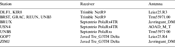
Figure 10 shows the estimated epoch-by-epoch GGTO values. The results indicate that the GGTO estimates vary within a range of 30 ns during the period of 13:17 to 16:25. It is noted that the GGTO estimates from the “Javad Tre_G3TH Delta” receivers at ZIMJ and GOP7 are significantly different from those from other receivers by an apparent offset. This offset indicates an existence of inter-system hardware delay, which is dependent on specific receiver/antenna types (Cai and Gao, Reference Cai and Gao2008). No significant offset was found between the GGTO values from Trimble and Septentrio receivers. During the period of 13:17 to 16:25, only IOV-1 and IOV-2 satellites were visible by all the 11 stations except that the REUN station could track signals from all the four IOV satellites. For consistency considerations, only the IOV-1 and IOV-2 observations were used together with GPS ones to estimate the GGTO and three-dimensional coordinates at REUN. At each GNSS station, the standard deviation (STD) of the GGTO parameter can be estimated at each epoch through the Least-Squares estimator. The epoch-wise standard deviation at each station was then averaged. The averaged STD varies in a range of 3–13 ns from station to station and the mean value is 5 ns for all the 11 stations.
Figure 10. Estimated GPS-Galileo time offsets at different stations on 28 May 2013.
Figure 11 illustrates the positioning errors and observation residuals for the combined GPS/Galileo absolute positioning using the pseudorange observations collected at REUN on 28 May 2013. During the period from 13:17 to 16:25 GPS time, four Galileo IOV satellites are visible. With the addition of four Galileo satellites, the average PDOP decreases from 1·6 in the GPS-only case to 1·4 in the GPS/Galileo integration case. The RMSs of GPS/Galileo positioning errors in east, north and up components are 1·338 m, 0·257 m and 1·386 m, respectively. The GPS and Galileo observation residuals are shown in the middle and bottom panels of Figure 11. Different colours represent different satellites. The residuals for most GPS satellites are stable during the three hour observation period except for satellites with low elevation angles. However, it appears that the observation residuals of the four Galileo satellites vary over time, which is likely caused by the residual errors of Galileo satellite orbit and clock offset. From Figure 8 it is easily understood that the larger observation residuals for IOV-1 and IOV-2 after 16:00 are due to their low satellite elevation angles.
Figure 11. Positioning errors and code observation residuals from combined GPS/Galileo absolute positioning at REUN on 28 May 2013.
In order to assess the accuracy improvement after adding Galileo to GPS observations, the 127 datasets are processed in both the GPS-only case and the combined GPS/Galileo case. Observations from all the visible GPS satellites rather than only four GPS satellites are used in the processing. The RMS of positioning errors for each dataset is computed and its distribution is shown in Figure 12. The mean and STD values of the 127 RMS errors are shown at the top-left corner of each panel. It is clear that in terms of the mean RMS value, the combined GPS/Galileo data can improve the positioning accuracy by approximately 10% in the vertical component over the GPS-only solution, although only four Galileo satellites are currently available. No significant horizontal accuracy improvement is observed.
Figure 12. RMS distribution of positioning errors for GPS-only and combined GPS/Galileo absolute positioning using 127 datasets collected at 17 MGEX stations from 18 May to 1 June 2013.
6. CONCLUSIONS
The current Galileo constellation consisting of four IOV satellites has the capability to perform position determination independently for the first time. This paper evaluates the performance of Galileo data in terms of carrier-to-noise density ratio (C/N0), pseudorange multipath (including noise), satellite orbit and satellite clock errors, and finally single point positioning accuracy, with a comparison to GPS data. Generally the Galileo signal carrier-to-noise density ratio (C/N0) has higher values than that for GPS. Our analysis results indicate that the Galileo E5 generally is strongest among all signals (C/N0 highest at REUN station and secondly highest at BRUX station). Overall, all Galileo signals are subject to smaller code multipath errors and noise than GPS signals at almost all satellite elevation angles. The Galileo E5 signal also illustrates the smallest code multipath and noise. The precision of broadcast ephemeris for each IOV satellite is analysed using precise ephemeris products as references. Four IOV satellites have a three-dimensional (3D) orbital accuracy of better than 5 m and clock offset accuracy better than 10 m.
The positioning solutions from the combined GPS/Galileo processing are analysed and results apparently indicate that a bias in the GPS-Galileo time offset (GGTO) estimates exists between different types of GNSS receivers. The absolute positioning performances using Galileo broadcast ephemerides are assessed using 15-day data collected at 17 MGEX stations. Results indicate that combined GPS/Galileo positioning can improve the positioning accuracy over GPS-only by about 10% in the vertical component. No obvious improvement is found in the horizontal directions. Galileo-only positioning can achieve a 3D position accuracy of about 6 m with measurements from four IOV satellites. The positioning accuracy is expected to enhance considerably when the future Galileo constellation of 30 satellites is formed and when the quality of Galileo broadcast ephemeris data and measurements are further improved.
ACKNOWLEDGEMENTS
The financial support from the Postdoctoral Science Foundation of Central South University and National Basic Research Program of China (No. 2013CB733303) are greatly appreciated. The support from the National Natural Science Foundation of China (No. 41274039) and the Hong Kong Research Grants Council (RGC) Early Career Scheme (ECS) Fund (Project No. PolyU 5325/12E) are gratefully acknowledged. Zhizhao Liu acknowledges support from the Program of Introducing Talents of Discipline to Universities (Wuhan University, GNSS Research Center), China. We thank Dr. Bruno Nava at The Abdus Salam International Centre for Theoretical Physics (ICTP), Italy for providing the source code of the NeQuick 2 ionospheric model. The International GNSS Service (IGS) is acknowledged for providing the MGEX data used in this study.


