1. INTRODUCTION
With the advancements of technology in marine electronics, traditional navigation instruments such as sextants and paper charts are being rapidly replaced by computer-based navigation systems. On one hand, this trend brings new facilities to assist people at sea. On the other hand, however, new equipment also creates new problems for the safety of navigation. Investigation into accidents such as the grounding of the Ovit in the Dover Strait in 2013 or the Muros on the east coast of the United Kingdom in 2016 raises concern about the potential negative effects of technology on safety (Maritime Accident Investigation Branch (MAIB), 2014; 2017). Reports from maritime agencies as well as academic studies indicate that electronic navigation systems, if designed improperly, could have adverse effects on human performance (Rowley et al., Reference Rowley, Williams, Barnett, Pekcan, Garfield, Northcott and Crick2006; MAIB, 2008; Barsan and Muntean, Reference Barsan, Muntean, Panait, Barsan, Bulucea, Mastorakis and Long2010).
When developing marine electronic navigation systems, there are many instances where engineers focus primarily on technical aspects and do not adequately consider the needs and capabilities of users. Consequently, many systems are designed to be technologically functional but end up being difficult for users to operate, increasing the probability of erroneous actions (Grech et al., Reference Grech, Horberry and Koester2008). Another issue with existing navigation systems is the lack of a common design language among manufacturers. Products from different companies often have different “look and feel”. Seafarers, whose job requires moving from one ship to another, face difficulties familiarising with new equipment when joining ships. The problem is even more serious for pilots, who often board several ships a day (The Nautical Institute, 2008).
To address this concern, the International Maritime Organization (IMO) started developing guidelines on standardised modes of operation (S-mode) as part of the e-Navigation initiative (IMO, 2015b). The basis of S-mode is a set of prescribed standards for several elements on navigation displays, focusing on the radar, Electronic Chart Display and Information Systems (ECDIS), and relevant components of Integrated Navigation Systems (INS). S-mode is expected to reduce diversity in design and, at the same time, improve the usabilityFootnote 1 of navigation systems (IMO, 2015b). To achieve the intended goals, S-mode must be developed to reflect the way seafarers work at sea. The research reported here was designed to contribute to the development of S-mode by studying how frequently seafarers use each feature of bridge systems. To collect data, an online survey, using SurveyMonkey software, was distributed to the global seafaring community with the support of the Nautical Institute (NI). The objective was to provide input to improve the usability of user interfaces in future navigation systems.
2. BACKGROUND
The e-Navigation initiative was started as a strategy of the IMO to regulate the application of information technology to improve safety and efficiency in shipping. Among the intended benefits, e-Navigation aims to bring a user-centric approach to equipment design, which matches the system to “the characteristics of intended users and the tasks they perform, rather than requiring users to adapt to a system” (IMO, 2015a). Among the projects to implement e-Navigation, S-mode specifically concerns the user interface of navigation systems and aims to standardise several elements of the navigation displays, such as icons and terminologies or the grouping of information. Following the user-centric design approach of e-Navigation, S-mode intends to determine the optimal way to present functions and data on navigation systems, allowing seafarers to operate bridge equipment with ease. Being user-centric and standardised, S-mode is expected to bring the benefit of increased usability as well as reducing the effort needed in familiarisation with new equipment when moving between vessels.
The first step in developing S-mode is studying how seafarers work on board and identifying what they require from navigation equipment. However, until now few studies have been conducted to support the IMO S-mode project. Jacobson and Lutzhoft (Reference Jacobson and Lutzhoft2008) performed a study using questionnaires, interviews and workshops with participants from the Swedish defence and merchant navies to identify commonly-used settings for marine radar. This study was limited both in terms of sample size (56) and the study object (only radar was studied). A second study was carried out also using questionnaires to identify which bridge equipment and features should be standardised and explore the user-preferred layout of ECDIS displays (Lutzhoft et al., Reference Lutzhoft, Grech and Jung2016). Another approach to determine the way seafarers interact with bridge equipment uses eye-tracking devices to track the navigator's eye movement patterns when engaging in navigation duties (Lützhöft and Dukic, Reference Lützhöft and Dukic2007; Hareide et al., Reference Hareide, Ostnes and Mjelde2016; Hareide and Ostnes, Reference Hareide and Ostnes2017). However, existing studies can only determine different areas on the displays that attract users' attention but cannot precisely identify the dwell time for individual pieces of information (Hareide and Ostnes, Reference Hareide and Ostnes2016). Other studies were undertaken by the Comité International Radio-Maritime (CIRM) and members of the Navigation Working Group of the Sub-Committee on Navigation, Communications and Search and Rescue (NCSR) but their results are yet to be published (IMO, 2017). To the best of our knowledge, there has never been a study in the maritime context addressing the frequency of feature use – an important aspect of a user interface.
2.1. Frequency of feature use in computer systems
For computer-based systems, frequency of feature use is an important element for successful user interface design, determining the organisation of menu items, the display layout, and the method of user interaction (Shneiderman and Plaisan, Reference Shneiderman and Plaisan2004).
First, since most complex computer-based systems have a high number of available features, only a portion of which will be used often, having all functions simultaneously presented can lead to cluttered displays, and eventually information overload. Given humans' limited information processing capacity, it is necessary to prioritise functions on the interfaces. More frequently-used functions should be made readily available while functions with lower frequency of use can be eliminated from the interface and made accessible through secondary paths (Brown, Reference Brown1998).
Additionally, as users gain experience with a system, they will benefit from a means to quickly access functions that are frequently needed (Nielsen, Reference Nielsen1993). For this reason, functions with high frequency of use should be made accessible through advanced means such as shortcuts, hotkeys or macro facilities (Gong and Tarasewich, Reference Gong and Tarasewich2004).
Also, users of computer systems often need different functionalities for different scenarios. In the case of marine navigation systems, seafarers require different information for different tasks and navigational conditions. Adaptive user interfaces are interfaces that can automatically modify themselves to fit users' tasks and abilities, which can potentially reduce cognitive workload (Gajos et al., Reference Gajos, Czerwinski, Tan, Weld and Celentano2006). Data on frequency of function use can be applied to develop adaptive interfaces. By identifying information commonly needed in different scenarios, designers can create adaptive algorithms to make such information immediately available, once the corresponding conditions are met (Findlater and Gajos, Reference Findlater and Gajos2009).
Without information on frequency of use, designers are forced to rely on their intuition, which, in many cases, contradicts user requirements and can lead to poor system usability (De Souza and Bevan, Reference De Souza, Bevan, Diaper, Gilmore, Cockton and Shackel1990).
To address this shortcoming, we conducted a survey to identify how frequently mariners use each of the features available on standard navigation systems. INSs are developed to support safe navigation by integrating navigational data from various individual equipments and provide the bridge team with centralised access to necessary functions and information. Even though not all vessels are equipped with an INS, the standard functions and information available on an INS are similar to those of conventional bridge systems. The difference is that an INS allows for centralised access to such navigation features.
3. METHOD
The survey consisted of 64 questions collecting users' ratings on the frequency of checking/operating/adjusting settings for features of INSs as specified in the performance standard for INS (IMO, 2007).
Following the IMO performance standards, INS functions and information are categorised into six task groups, namely Route planning, Route monitoring, Collision avoidance, Navigation control data, Status and data display and Alert management (IMO, 2007). Several INS features are listed under more than one task group.
In each survey question, we asked people to rate the frequency of use of an INS feature using a rating scale consisting of four frequency levels, namely “0-2 times in my whole career”, “Once or twice in a voyage”, “Once or twice a watch” and “Several times a watch”. Respondents had the option to reply “Unclear question” if they found the question confusing and “Not applicable” if the feature was not available on their systems. Besides rating the frequency of use, participants could also write feedback on their experience using the feature in a comment box. This feedback was treated as qualitative data and was analysed separately from the frequency of use rating.
3.1. Participants
The survey was announced in issue 14 of The Navigator – a publication of The Nautical Institute that is specialised in promoting professional seamanship, published in 2017. The majority of the participants, therefore, were assumed to be readers of the magazine. The authors also specifically contacted seafarers from the Australian Maritime College, Vietnam Maritime University, Odessa National Maritime Academy, Western Norway University of Applied Science and Dalian Maritime University to increase the number of participants.
3.2. Procedure
The survey was open between 1 February 2017 and 15 July 2017. The collected numerical data were processed automatically by SurveyMonkey and analysed using the Statistical Package for the Social Sciences (SPSS) version 22.0. The text answers were extracted manually into document files and analysed using the qualitative data analysis software NVivo version 11.
3.3. Analysis
3.3.1. Frequency of use rating
After initial analysis, we found that the data were strongly skewed toward the category “Frequently during a watch” and decided to combine two categories “0-2 times in my career” and “Once or twice in a voyage” into a single category “Not used every watch”. Three of the features were found to be “special cases” and their results will be discussed in the Findings section.
3.3.2. User feedback
Given the open-ended nature of users' feedback, an inductive approach allowed us to identify patterns and categories that emerged from the data (Thomas, Reference Thomas2006). For each feature, we read the comments several times to develop initial coding rules. We then started coding the data in NVivo following the initial coding rules and modified the coding as we proceeded. Each time we changed the coding rules, we re-read the coded content and modified the coded data accordingly. The process was repeated until no new theme emerged, at which a stage of inductive thematic saturation was reached (Saunders et al., Reference Saunders, Sim, Kingstone, Baker, Waterfield, Bartlam, Burroughs and Jinks2017). At the end of the coding process, three major themes emerged from the data, namely “Conditions” – factors affecting the frequency of use of a feature, “Purposes” – the reasons for using a feature, and “Usability Issues” – difficulties encountered by seafarers when working with navigation equipment. The results allowed us to generate a descriptive overview of the way seafarers operate bridge systems, which is presented in Section 4 – Findings.
3.4. Limitations
In total, 601 seafarers of various levels of experience and areas of operation replied to the survey. However, the numbers of frequency votes varied between questions, ranging from 276 to 435, due to two reasons. First, many respondents preferred replying in comment boxes rather than using rating scales. Secondly, the gradual reduction of response rate throughout the survey shows survey fatigue to be a factor affecting the response rate at the end of the survey.
4. FINDINGS
We present the findings in the form of a guideline for manufacturers of marine electronics, structured into three parts: frequency of use, factors affecting the use and usability issues of existing navigation systems.
The findings are combined from the analysis of both quantitative and qualitative data. The numerical data allow us to establish an overview of how frequently seafarers use each INS feature, which is presented in Section 4.1. The qualitative user feedback provides a richer understanding of the use of each feature. Therefore, frequency of use should be considered in the light of the analysis of user feedback, which is discussed in Sections 4.2 and 4.3.
4.1. Frequency of use
As discussed in Section 3, INS features were categorised into six task groups with some features serving more than one task (IMO, 2007). Following the same categorisation, we present results of frequency of use rating in Table 1, starting with features serving multiple task groups and following with features serving only a single task group. The grey colour is used to indicate categories with the highest number of votes. There were three cases where we were not able to obtain a clear frequency of use. These special cases are discussed in Section 4.1.1.
Table 1. Frequency of use rating for INS features. The grey colour indicates categories with the highest number of votes

4.1.1. Special Cases
4.1.1.1. Search And Rescue Transponder (SART) and radar beacon signal processing function
Paragraph 5.3.4 of the revised performance standards for radar equipment (IMO, 2004) requires X-band radar systems to be able to detect SARTs and Radar beacons in the relevant frequency band. However, the regulation also requires that it is possible to switch off those signal-processing functions, which will prevent X-band Racons and SARTs from being detected and displayed. A status should be indicated when these functions are turned off. The survey results show that the majority of responders were not aware of this feature and mistook this function with the routine testing and maintenance of SART units. However, this can also be interpreted as users almost never using this feature in practice.
4.1.1.2. The active mode of steering or speed control
This feature provides data for manual control of a ship's movement and is required under the provisions of paragraph 7.5.2.1 of the INS performance standards (IMO, 2007). When designing the survey, we changed the wording from “The active mode of speed and steering control”, as in the regulation, to “The active speed mode” and “The active steering mode”, which confused readers. Consequently, the survey received a high percentage of “Unclear” and “Not applicable” responses. The comments from users further demonstrate the confusion among respondents in interpreting the questions. Consequently, we have excluded these features from the report.
4.1.1.3. Ice Data
This feature is an optional function according to paragraph 7.3.3 of the INS performance standards (IMO, 2007). The survey showed that the use of this information significantly depends on the season and area of operation, and most respondents have not experienced situations where this feature is needed. Consequently, we did not collect sufficient data to determine how frequently seafarers check this information when navigating in ice-infested waters. However, respondents did comment that this information would be critical for ice navigation. In all other conditions, Ice Data is never used.
4.2. Factors affecting the use of navigation equipment
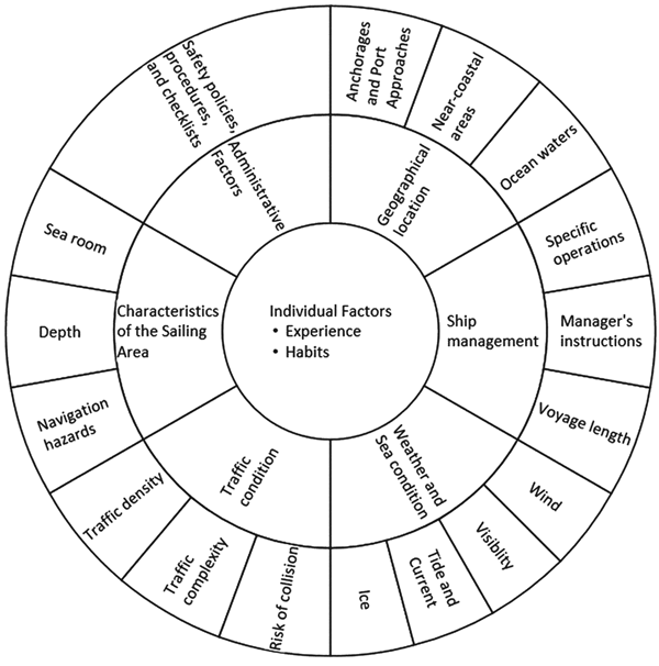
Human variability and adaptability make it very difficult to analyse user interaction without considering the context of use, or as Sherwood Jones et al. (Reference Sherwood Jones, Earthy, Fort and Gould2006. P. 5) put it: “It all depends …”. Interestingly, our analysis of word frequency using NVivo 11 finds “depends” to be the most common word used in users' comments. The survey results show that seafarers do not operate bridge equipment in the same manner all the time but rather adjust and adapt to the prevailing situation, as do many operators in time-critical or demanding operations (Woods et al., Reference Woods, Dekker, Cook, Johannesen and Sarter2010; Rankin et al., Reference Rankin, Lundberg, Woltjer, Rollenhagen and Hollnagel2014). Our research shows factors affecting the use of bridge equipment can be grouped into the following categories:
• Individual factors – experience-based decisions and professional habits
• Administrative factors – safety policies, procedures and checklists
• Characteristics of the sailing area – sea room to manoeuvre, navigation hazards, and depth
• Traffic condition – traffic density, traffic complexity and risk of collision
• Weather and sea conditions – all hydro-meteorological conditions of the area
• Ship management factors – voyage length, manager's instruction and specific operations
• Geographical locations – ocean waters, near-coastal areas, anchorages and port approaches
These influential factors are summarised visually in Figure 1.

Figure 1. The main determinants of frequency of use for marine navigation systems.
In the following sections, we will discuss each category in detail.
4.2.1. Administrative and individual factors
It is a common belief in the maritime industry that “… accidents are preventable through following correct procedures …” (IMO, 2008). With the introduction of the International Safety Management (ISM) Code (IMO, 2018), the industry has become more proceduralised, and administrative measures such as policies, procedures and checklists have been developed as primary safety measures (Oltedal, Reference Oltedal2011). The survey results show the explicit involvement of administrative factors in the way seafarers operate navigation equipment, as seen in an extract from users' feedback:
“It all depends on the situation; we got most of these questions covered in our checklists/ route planning, it is clearly someone with less seagoing experience who has made these questions” (ID 6193256832)Footnote 2
Under normal conditions where there is no perceivable danger to the vessel's safety, the watchkeeper uses navigation equipment to periodically monitor the situation, plan for upcoming events and carry out recording duties. The way people operate bridge systems, in this case, is characterised by routine and non-routine inspection of information. Routine inspection follows safety procedures, and non-routine inspection is determined by the watchkeeper's evaluation of the situation, which in turn, is influenced by his/her experience and/or professional habits. The types of information of interest under these circumstances belong to categories “Route monitoring information”, “Navigation control data” and “Status and data display” of INS task groups (see Table 2).
Table 2. List of INS features influenced by Administrative and Individual Factors

Most seafarers refer to these experience-based decisions and professional habits as “good sea practice” or “good seamanship”. However, while procedures and checklists can be traced back to shipboard Safety Management Systems (SMS) under the provision of the ISM Code, the nature of this study does not allow us to establish a clear understanding of what respondents referred to as “good seamanship”. Nevertheless, the results demonstrate that in general, seafarers answer that they operate navigation equipment “… always as per the good sea practice and Company SMS procedures.” (ID 6123532505)
In summary, under normal conditions with no perceivable dangers to the vessel's safety, the main uses of navigation systems are to maintain situation awareness and record data. The information of interest, in this case, is data for monitoring navigation status of the vessel and system performance. Users inspect such information both routinely, following safety procedures, as well as non-routinely based on personal judgement.
4.2.2. Characteristics of the sailing area
When the nature of the sailing area causes concern to the safety of navigation, seafarers start monitoring a wider spectrum of navigational information more intensively. Users' feedback shows particular concern regarding the available sea room to manoeuvre and depth of the surrounding waters as well as the presence of other navigational hazards. The main purpose of using navigation systems in these situations is to ensure that the ship does not run into danger. As a result, seafarers pay greater attention to monitoring the ship's position, taking into account external factors such as tides and currents, utilising active functions such as VRM or EBL to calculate and ensure navigation safety while considering alternative route options. Table 3 shows INS features more frequently used when navigating in areas with difficult characteristics.
Table 3. List of INS features influenced by the characteristics of the sailing area

In summary, when the characteristics of the sailing area are of concern, the seafarers' primary objective is to ensure that the vessel does not run into danger. The features of interest in this situation are the vessel's position, route information and other information necessary to control the position relative to the planned track and navigation hazards in the vicinity
4.2.3. Traffic conditions
In difficult traffic conditions, the results show a surge in the use of features for collision avoidance, which indicates avoiding collisions to be the primary purpose of using bridge equipment in high-traffic areas. Seafarers actively utilise interactive functions and monitor relevant information to avoid close quarters situations as well as considering alternative route options. Table 4 shows INS features that are used more frequently in congested waters or under complex traffic situations.
Table 4. List of INS features influenced by traffic conditions

4.2.4. Weather and sea conditions
The results show that in unfavourable weather and sea conditions, seafarers monitor weather data and forecasts more intensively, as demonstrated by increased observations of hydro-meteorological data. At the same time, several system functions will be used more frequently to avoid collisions or prevent running into hazards under the effects of adverse weather. Alternative route(s) can be displayed together with the active route for re-route consideration if needed. Table 5 shows INS features used more frequently under adverse weather.
Table 5. List of INS features influenced by weather and sea conditions

4.2.5. Ship management factors
Factors such as voyage length, manager's instruction and specific operations such as tank cleaning play an insignificant role in the way seafarers operate navigation equipment but were mentioned in the user feedback. Specifically, a change to the passage plan may occur due to a manager's instruction or the need to conduct special operations, which in turn require a non-routine use of route modifying tools or adjusting AIS data. In addition, propulsion data will be monitored to ensure efficient fuel consumption.
4.2.6. Geographical location
Feedback from users indicate a clear distinction in the use of INS features between ocean waters and coastal areas. The frequency of use increases for almost all features when the vessel enters coastal areas, except for LAT/ LON data.
However, we also observed that the list of functions with increased frequency of use in coastal and harbour areas corresponds with the list of functions used more often in congested waters and areas with the presence of navigation hazards. Areas closer to shore usually have higher traffic density and their restricted depths give rise to the presence of navigation hazards. For that reason, we believe that this observed difference in frequency of use of bridge systems between geographical areas occurs due to the difference between traffic conditions and characteristics of those locations. However, the survey results do not provide us with sufficient data to analyse this matter in detail. Therefore, the influence of geographical locations on the use of navigation equipment will be investigated in subsequent studies.
4.3. Usability issues
Regulation V/15 of the International Convention for the Safety of Life at Sea (SOLAS) requires the design and arrangement of navigation systems and equipment on the bridge to be undertaken with the aim of allowing for continuous and effective information processing and decision-making while preventing or minimising excessive or unnecessary work which may distract or interfere with the vigilance of the bridge team and the pilot (IMO, 1974). However, through users' feedback, it is clear that seafarers still face information overload when working with existing navigation systems, particularly with Radar/Chart Overlay and Alert management.
4.3.1. Radar/chart overlays
Comments from survey participants show two general attitudes among seafarers toward the use of radar/chart overlays. The first group found the overlay feature useful and replied that they often use this feature if it is available on their systems. These seafarers reported using radar/chart overlay to:
• reconfirm the interpretation of the radar image
• check if there is a difference between radar echoes and chart objects to reconfirm the location of aids to navigation and check the accuracy of the Global Navigation Satellite System (GNSS) receiver
The second group of seafarers, on the other hand, commented that the overlay function does not work as expected with information overload being a major concern. These seafarers commented that the overlay feature often resulted in large amounts of data on the displays, making it difficult for operators to locate information. Additionally, there is the possibility that crucial information can be covered by non-crucial data.
“I prefer to use radars and ECS/ECDIS separately. I am concerned about losing a target underneath a useless piece of charted data. Most cruise companies insist on combining radar overlay and an astonishing amount of data on the same screen” (ID 6112984980).
“…I find the chart overlay can cause information overload and sometimes the tracked targets are less visible with many data in background …” (ID6097265361).
User feedback indicates that the large amount of data displayed when the overlay feature is activated can be problematic to handle and consequently render the feature less useful. However, many users consider radar/chart overlay to be a useful tool to assist with navigation and thus, the feature can enhance safety at sea if the issue of information overload can be resolved.
While radar/chart overlay is a supporting feature, alert management is crucial to maintaining safe operation of the ship. For this reason, the usability issues with alert management will be discussed in detail in the following sub-section.
4.3.2. Alert management
The handling, distribution and presentation of alerts plays an essential role in facilitating situation awareness, supporting decision-making and improving the safety of navigation. The main purpose of alert management is to assist the bridge team in recognising an abnormal situation, identifying the origins of errors and deciding appropriate actions (IMO, 2010).
Regulatory documents require alert systems to be designed to avoid unnecessary distraction and reduce cognitive workload on the operators while, at the same time, being able to communicate necessary information (IMO, 2010). However, feedback from survey participants shows excessive alerts to be a frequently-encountered issue. Survey respondents commented that many models generate a large number of alarms, both visual and audible, which lead to information overload and can either hinder crucial information or distract the officer of the watch from attending to more important matters.
“The alarms are excessive on certain brands; annoying alarms replace pertinent manoeuvring or target data.” (ID 6112984980)
“So many alarms all the time. More focus on this than anything else.” (ID 620554563)
This is, however, not a new problem. Information overload due to redundant and superfluous alerts has been well documented in existing literature (Sherwood Jones et al., Reference Sherwood Jones, Earthy, Fort and Gould2006; Motz et al., Reference Motz, Höckel, Baldauf, Benedict, Dalinger, Widdel, MacKinnon and Mann2009). Several factors have led to an increased number of alerts in bridge systems, one of which is the integration of alert signals from external sources such as the Global Maritime Distress and Safety System (GMDSS) or the AIS. Additionally, most systems on the bridge are now computer-based, making it easier to introduce new alerts. This increased automation of bridge systems leads to the trend to introduce additional alerts without proper consideration of their operational impacts, especially following safety reviews (Sherwood Jones et al., Reference Sherwood Jones, Earthy, Fort and Gould2006).
Although the issues with alert management facilities have been identified in previous studies, the results of this survey reaffirm that the problem is yet to be properly addressed. Given the importance of alert systems, information overload in alert management can have a serious consequence if not addressed properly, which is clear for the maritime as well as many other domains (Kerstholt and Passenier, Reference Kerstholt and Passenier2000; Motz and Baldauf, Reference Motz and Baldauf2007; Traub and Hudson, Reference Traub and Hudson2007). Since the survey did not allow us to reach respondents for follow-up questions, we were not able to investigate further into this matter. However, for the reasons stated above, it is suggested that subsequent studies on the usability of marine electronics should aim to address the issue of information overload, particularly in alert systems.
4.4. Application of the survey results in design
The findings of this research on the frequency of use for navigation functions and data can be applied to the user interfaces for marine electronics. A common principle in designing information architecture is that frequently-used features should be made accessible with the least operator action (Shneiderman and Plaisan, Reference Shneiderman and Plaisan2004). This reminds us of the basic T arrangement of analogue flight instruments found in many aircraft cockpits, where the six most used flight instruments were placed in a T shape directly in front of the pilot (United States Department of Transportation, 2012). Infrequently used features, on the other hand, can be made accessible through secondary paths to avoid cluttering the display (Brown, Reference Brown1998). However, infrequently used but essential features such as the SAR and MOB modes should still be readily available at all times.
Additionally, since the use of navigation equipment is situation dependent, users can benefit from an algorithm to adapt the interface to the prevailing circumstances. The concept of an interface capable of adapting to individual users or changes in situations is not a novel concept and has been introduced in other industries (Benyon, Reference Benyon1993; Langley, Reference Langley1999). Within the maritime domain, Baldauf et al. (Reference Baldauf, Benedict, Hockel, Filipe and Cordeiro2009) proposed a similar approach to reduce the number of collision warnings. The basis of this is developing and applying an algorithm for self-adaptation of CPA limits according to current navigation settings, thus reducing the number of collision alerts activated as the vessel travels in near coastal areas where closer passing between vessels are expected. For a broader scope of the whole user interface, an adaptive interface may highlight or make ready the functions and data necessary for the current situation. Still, researchers face multiple challenges making the notion of adaptive user interfaces viable, which are outside the scope of this study.
5. CONCLUSION
This article presents the results of a survey on the frequency of use for functions and information available on integrated navigation systems. The frequency of use for each feature should be used as input for designing menu items and display layouts on the interfaces of navigation equipment. For instance, frequently used features should be made readily available or easily accessible. Additionally, the survey shows that the use of navigation systems is situation dependent, and seafarers require different sets of functions and information for different scenarios. Factors affecting the frequency of use include:
• Individual factors – include experience-based decisions and professional habits
• Administrative factors – include safety policies, procedures and checklists
• Characteristics of the sailing area – include available sea room for manoeuvre, depth and the presence of navigation hazards
• Traffic condition – includes traffic density, traffic complexity and risks of collision
• Weather and sea condition – includes wind, visibility, ice, tides and current conditions
• Ship management factors – include instructions from managers, voyage length and specific operations such as tank cleaning or ballast water exchange
• Geographical location – includes ocean waters, near-coastal areas and anchorages and port approaches
To improve usability, systems should be provided with a means to adapt to situations, such as a self-adaptation algorithm for highlighting information necessary under the prevailing circumstances.
Information overload was reported to be the major usability issue with existing bridge systems, especially with radar/chart overlays and alert management. Respondents were concerned that this issue could make it harder to identify crucial information or alternatively distract the officer of the watch from attending to more important matters. Although this is not a new issue, this survey reaffirms that the problem has not been properly addressed.
This is the first of a series of studies conducted to specify user requirements when working with navigation systems in order to provide input to the IMO guidelines on Standardised modes of operation (S-mode). In subsequent studies, we will investigate factors affecting frequency of feature use identified in this study as well as other aspects of user interfaces that influence the way seafarers operate navigation equipment.
The development of modern marine electronics has introduced a new way of working on board ships and brought additional assistance to the navigator. However, improper design can make users expend more mental effort to control navigation systems effectively, causing negative effects on their overall performance. Optimal system design must include actions to improve human-computer interaction, allowing the mariners to handle all essential information and take full control of the situation with ease. To achieve this aim, bridge systems must be designed following a user-centric approach, taking into account the requirements of intended users within the context of use.
ACKNOWLEDGEMENTS
This research was conducted with great support from the Nautical Institute. We also want to show our gratitude to all the seafarers and maritime researchers who took the survey and provided invaluable data for this study.
ETHICAL STANDARDS
This project was approved by the Tasmania Social Sciences Human Research Ethics Committee under the Ethics Reference Number H0016285.