


In 1977, I published an article that sought to use the baptismal records of Catholic priests and missionaries in the Kingdom of Kongo to find demographic data.Footnote 1 Although the priests did not produce classic parish registers such as those used by demographic historians in Europe, they did record the numbers of children they baptized in their missionary tours. Their visits to regions varied in frequency; some districts were visited regularly, others less regularly, and from this irregularity, I realized that it was possible to use areas which had been visited sometimes every year, other times every two or even every five years to construct a crude age pyramid.
I then matched the ratios between these ages to a model stable population, which uses data on birth and mortality rates to calculate population structure. Such a model can be quite accurate in predicting missing data if the data entered in is precise. For example, for older periods in European history, baptismal registers that allow the exact date of birth to be ascertained (and often exact dates of death as well) provide ample and reliable base data. The data I deployed does not come close to that standard; it must be considered as having a fairly wide range of variation and should be considered more as an order of magnitude than a true estimate. I used Cole and Demeny's well-known model stable population to determine infant mortality, average life expectancy, and total population size for Kongo.Footnote 2
Soon afterwards, I discovered a baptismal register for Manguenzo (see Fig. 1), a Solongo (people of Soyo) community in the hinterland of Kakongo, which had over 700 children baptized at one place and one time listed by age (all under 7 years old) for 1773 and 1774. This provided a good snapshot of the age distribution at a specific point in time and allowed me to assign the population of Kongo to a slightly different model stable population with more confidence, but one which had effectively the same characteristics as my original choice.Footnote 3
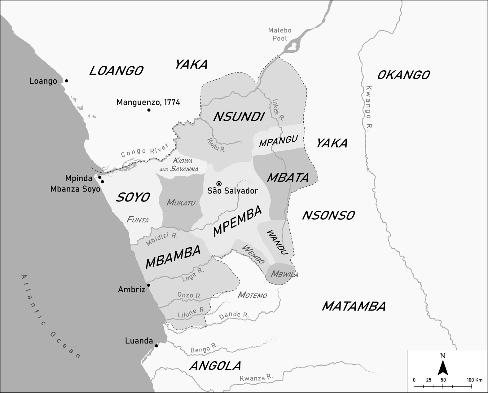
Figure 1. The Kingdom of Kongo in 1623. Map by Matilde Grimaldi.
Note: Manguenzo, which did not exist in 1623, is included on the map for reference purposes where it was situated in 1774.
From my perspective, the most important finding of this data was the recognition that Kongo's demographic profile, in particular its levels of infant mortality and life expectancy, suggested rates quite similar to those recorded in Western Europe by historical demographers working on the sixteenth through eighteenth centuries.Footnote 4 These included high rates of infant mortality (by today's standards, even for Africa), generally in the 250 to 300 per thousand level, and low levels of average life expectancy, hovering around 35 years. This finding greatly problematized the unconscious paradigm that many Africanists had been using, that Africa was as underdeveloped with regards to Western Europe in the seventeenth century as it was in the twentieth. This clearly was not true; African economies and societies were just as capable as their European counterparts in meeting the nutritional, environmental, and medical needs of their population, which must be considered an important hallmark of economic development.
The second finding was that Kongo had a much smaller population than had been previously assumed, and that it was characterized by two significant nodes of high population around the capital city of São Salvador (now Mbanza Kongo) and Mbanza Soyo on the coast. It made it clear that one of the key components of Kongo's degree of political centralization was in part determined by the mass of population living around the capital (within a roughly 30-kilometer radius), and that one of the keys to its devastating civil war following 1665 was the loss of the population mass and the emergence of Mbanza Soyo as a rival node of high population.Footnote 5
Igor Matonda Sakala, in an important contribution to the discussion of the population history of the Kingdom of Kongo, recently proposed that the population estimates I developed for the kingdom in 1977 were too low.Footnote 6 He challenged the paper on three bases in particular. The first challenge was a specific one: that I had seriously miscalculated the population of some of the districts in Soyo's eastern side, rendering it much smaller than it should have been and thus undermining the overall thesis that rural populations were low. He coupled this with an assertion that some of my less-well-grounded data for Kongo's eastern districts as a whole could be reinterpreted to predict a higher population, and cited a number of literary sources pointing to higher populations in the Inkisi Valley, an area where he had worked as an archaeologist.
Secondly, he also proposed that I had not considered that the data I assembled might be altered by considering the potentially uneven depth of Christian belief of the people of Kongo. His third objection was that I had not considered the impact of the slave trade, both as a drain on population and as a part of a series of wars, droughts, and famines that accompanied it, leading to secondary depopulation.
Given that the demographic impact of the slave trade on African populations is one of the most significant themes within the continent's historiography, the second half of this paper will present substantial evidence demonstrating that Kongo's population was affected only to a limited extent before the mid-eighteenth century. However, since the challenges primarily addressed the issue of population size, I will address these first. In calculating the total population, I used the relatively small areas that I had data for to project average density over the whole of the kingdom. Clearly if there were even relatively small errors in calculating population density, they would amount to potentially very damaging, incorrect estimations for the larger kingdom. To start, I want to address Matonda's contention that I had seriously underestimated the population of eastern Soyo, as his revision of that calculation was an order of magnitude greater than my original estimation.
In his revision of my estimates for Soyo, Matonda proposed that I had erroneously calculated the population of the regions called Kiowa and Savana. These estimates were based on baptisms reported by the Italian Capuchin missionary Francesco da Troyna in the early eighteenth century. When he recalculated them, he proposed that a correct estimate for the region would raise its population from my estimation of 12,914 to 65,199, and the density from about 4 people per square kilometer to 25 per square kilometer.Footnote 7 Potentially, this error would increase the population sixfold and would substantially damage the rest of my work.
Matonda however, misread the underlying text and my interpretation. He had understood that da Troyna had baptized a total of 2,282 people, which he used as a base for his total population estimate, using the same methodology I had. In fact, da Troyna's report shows that his baptisms there were conducted during two separate missions, almost certainly in two different years, and he wrote, ‘in Sevana 2 volte 20 giorni di missione; Battisime 828 . . . in Quioa due volte 33 giorni di missione; Battesimi 1454’.Footnote 8 In order to make an accurate assessment, one would have to determine the ages of the children in each visit and during which years these occurred. These are unknown, but if we assume da Troyna's two missions occurred in different years, then the population total would be at least one half of his estimate, but possibly less. To get at the correct number of children there under the age of one, I used Antonio Zucchelli's baptisms from 1701, or 452 under the age of one, to calculate population in the same area.Footnote 9 Using the 3.5 per cent figure for children under the age of one (calculated from the Model Stable Population I used), we get 12,914 people.
Matonda also claimed a second, but less significant error in challenging my estimate of the population of Funta, contending that I had misread da Troyna's account again and reported only half the number of baptisms, and so raised my estimate from 3,700 to 4,728. In this case da Troyna visited the area twice, first in 1706 and again in 1707, and left a lump sum total of the people he baptized in both years. But as Lorenzo da Lucca had also visited Funta in 1705, I split da Troyna's number in half in order to arrive at an estimate of the population under the age of one in this period.Footnote 10 Thus in both cases, as it happened, my estimations ought to remain standing as originally published, and the data from Soyo could still remain valid.
These corrections, however, do not overthrow the larger challenge that Matonda posed for my work, primarily based on a critique of my evidence for the northeastern part of Kongo. This area fell into the region I called ‘the Centre and East’, which I posited had higher population densities than rural populations in Soyo and Mbamba, but which he argued were still too low. For this region, I had based my estimates on several different samples: baptisms done by Girolamo da Montesarchio and Joris van Gheel in the 1650s, and then by Filippo da Galese and Luca da Caltanisetta at the end of the century.Footnote 11 Mostly they covered the valley of the Kwilu River and some territories along the south shore of the Congo River, although some included stretches of the Inkisi valley.
Unlike Soyo, where a convergence of several missionary tours allowed me to estimate the population of a fairly large province, the estimates for the east were from much smaller areas, and relatively small changes in their estimated population density would be greatly magnified by being used as the basis for assessing the population of a much larger area. The microgeography of the area that the missionaries sampled is critical to understanding where those people likely to take their children to the missionary for baptism were located. In order to make my density calculations for this area, I redrew Jean Cuvelier's map of the region that illustrated his summary and translation of Girolamo da Montesarchio's account, which I believe he constructed from both documentation and surveying on the ground.Footnote 12 However, to obtain a better view of the geography, I also studied the region's physical geography and at times redrew Cuvelier's borders based on close study of 1942–50 Angolan topographical cadastral maps, which showed elevations at hundred-meter intervals.Footnote 13
In making those calculations, I plotted the routes of each of the travelers against my revised political borders on the topographical map and identified areas where people would be likely to carry their children to be baptized. The country was often quite mountainous with deep valleys and mountain ranges. To understand likely catchment areas for the missionaries, I defined what I thought of as slopes that were too difficult to navigate to determine the shape of valleys for human travelers; I did so by matching clusters of contour intervals against travelers’ descriptions of detours they had made because of steep terrain. These sharp breaks in the land then defined the borders of the catchment areas.Footnote 14
Once I had calculated the missionaries’ route and the likely homes of those families that took their children for baptism, I used that data to calculate the areas for the density estimates. Thus, I was not actually using administrative units, as Matonda's critique maintains, but only those parts of units that fit into the itinerary of the missionary.
However, in making these estimates, and especially in extrapolating them to the rest of the region, I did make an important error. I calculated areas from the crest of mountains on one side of the valley to the crest on the other side, and thus expanded the region to include what were certainly uninhabited upland areas. Clearly, regions with significant uninhabited areas would have lower densities than those areas where elevation was not a factor. While in some cases the area included less rugged terrain, it would be a mistake not to assume that in the flatter regions, such as the Inkisi valley in particular, there would be considerably higher density.
On that basis, I accept Matonda's critique that the densities I calculated, starting at 3.5 per square kilometer in 1650 and rising to 4.0 by the end of the century, were too low and that extrapolating them to flatter regions was to underestimate density and total population even further. At least in part, my assumptions about terrain and occupation were shaken when I traveled in person along the Inkisi River in 2011, from Cambambe to Maquela do Zombo (and then west to Mbanza Kongo). It was clear to me that the valleys were quite broad and that it would be likely that the population would have been greater. What the larger density would be, however, I can offer no serious suggestion from this data.
Matonda's second objection concerned the depth of Christianity in Kongo. He located a number of situations in which missionaries had a hard time carrying out their baptismal duties, using these as evidence of the potential lack of enthusiasm of people for Christianity. Clearly, if only a part of the population did not accept or even rejected Christianity, the use of baptismal statistics would be rendered, if not useless, considerably less useful. Recognizing such an objection, I dealt with this question in the original paper, primarily by citing a fair number of sources, written mostly by Capuchin missionaries, but also from some outside observers. These sources spoke of the overwhelming enthusiasm that Kongo people had for baptism, whatever other ideas they had about the faith.Footnote 15 Furthermore, the question of reception of the missionaries, who were not always liked, would be applicable only if the areas for which we have baptismal statistics were undergoing rejection of missionaries at the time, and there is no evidence for those specific cases that there was a lack of enthusiasm. We can speak of this with confidence, since those missionaries who reported their exact baptismal totals also described their reception in detail.
It is important to add that research on the conversion of the Kingdom of Kongo has advanced since 1977; before that date, many scholars had viewed missionaries to Kongo as operating in a colonial or semicolonial setting. In fact, it was the nearby Portuguese colony of Angola in this period which fitted more or less exactly such scholars’ vision of a resistant population, and missionaries frequently noted the difference in their reception in the two societies. In Kongo, they had no doubt about its people's commitment to Christianity.
The history of the church in Kongo can explain why baptismal records probably do reflect the commitment of the whole population to the religion. After a brief encounter with Portuguese mariners in 1483, the Kongo elite decided to send a high-level delegation to Portugal to investigate Christianity along with the prospects for an alliance, and when that mission returned, the king and his subordinates accepted Christianity. Even while the delegation was in Lisbon between 1486 and 1491, they studied Christianity and Portuguese along with Portuguese clergy, notably Vicente dos Anjos, and between the two they developed a rudimentary system for connecting Kongo's religion to Christianity, including, at least, the joint acceptance that a Kikongo name, Nzambi a Mpungu, was the name for the deity Christians called God. Thus, the Kongo elite was sufficiently satisfied with this joint theology that they accepted baptism without hesitation.Footnote 16
More to the point, both João Nzinga a Nkuwu (the king when the Portuguese arrived) and Afonso Mvemba a Nzinga (1506–42) worked to develop a religious infrastructure that would present Christianity to the population at large. This resulted in the establishment of a network of schools, led by literate members of the elite, that would catechize the whole of the country. The schools employed Kongo nobles, trained within the country, as schoolteachers (mestres d'escola). The beginnings of this system were already in place in 1516, and by 1530 the elite had completed a countrywide project. Missionaries working in the 1580s testified to the Inquisition that they did not need to do instruction in the faith, as the local school system did that.Footnote 17 That educational system continued without interruption for the rest of the precolonial period.Footnote 18
In Kongo, religious education was largely in the hands of the educated laity, and they permitted the sort of syncretic version of Christianity that formed in the sixteenth century to continue. They also insured that everyone was instructed in it, and part of that instruction included being baptized as a Christian duty. So although missionaries often railed against what they thought of as diabolic superstitions in Kongo belief, they were neither in a position to change it nor to teach counterviews effectively. What they did mostly was perform sacraments, the one part of Christian devotion that the Kongo church required.
Despite removing these various objections, the larger question of the total population of Kongo and the share of each district within it remains uncertain. Matonda did not venture a population estimate of his own, aside from noting literary sources suggesting higher populations from missionaries and travelers. However, fortunately, there is another source, unpublished and as yet still unused for its demographic potential, that can shed a great deal of light on the total population of Kongo in the early seventeenth century. This is an undated report on Kongo written by an anonymous Jesuit priest in the mid-1620s and found in the Brazilian Historical and Geographical Institute in Rio de Janeiro.Footnote 19
The document was a plea for more priests in the country, and it argued that Kongo's deplorable state was due to their lack, as it had ‘only eight curates who reside in the churches where the principle [lords] of the kingdom have their capitals’. There was one curate each in Nsundi, Mbata, Mbamba, Mpangu, Mpemba, Motemo, Mukatu, and a county whose name was illegible. The county in question had to be Soyo, as the only other provinces dubbed counties in Kongo were Wandu and Mpangu. Mpangu was mentioned on the list of provinces as having a curate, and Wandu was specifically mentioned elsewhere in the report as not having a curate. That the missing county was Soyo is confirmed by the words ‘and Pinda’ (Mpinda) that follow the hole in the manuscript, an undeniable reference to Soyo's port. Other areas that did not have a curate included Wembo and Okango, a semi-independent territory on Kongo's eastern frontier where there was a large Portuguese commercial community.
The crucial part of the report, however, was the assessment of annual baptisms from the kingdom from the year 1623. The priest wrote:
The children who are baptized every year in this kingdom both in the districts with chapels and those where there are not chapels with curates to administer this sacrament are forty thousand, a little more or less, which number is augmented by those they baptize at the See [the city of São Salvador], where they write down the baptisms that they give [which] are four thousand five hundred.Footnote 20
We can assume that the curates tried to cover whole areas whether or not there was a chapel, and if the curates were able to baptize all the children in their regions — which the text stresses were very large — in one year, then the population outside the see would be 1,143,000 for the areas that had a curate.Footnote 21 If, on the other hand, the curate took two years to baptize the children, he would be baptizing all those under the age of two in each of his tours, in which case the population outside the see would be only 655,000.Footnote 22 If he took more time still, the total number would be lower. Given that the curates were so few, it is highly unlikely that they managed the once-a-year visit, since the Capuchins, with a larger number of clergy, needed at least two priests to cover the province of Soyo in the early 1700s, and even then some areas were served less frequently.Footnote 23 Thus it seems much more likely that the lower number is correct.
While this tally has, clearly, a degree of uncertainty, given our lack of knowledge of the diligence and stamina of the various curates, it has the advantage of being a count based on the perceived usual number per year, probably an estimate based on the best results of an optimum circuit of priests. Its imprecision is in some ways a benefit, as it takes an estimated average rather than a single figure, which while far more precise, is also more subject to random local variations.
If we accept an average population density for the coastal provinces of Soyo and Mbamba in 1650 of 3 people per square kilometer, as I calculated in 1977 and use for the 1623 date, there were about 94,000 people living in that region. This means that the remaining area of Kongo had about 560,000 people at an average density of 5.7 people per square kilometer (assuming the low estimate of 655,000). This is considerably larger than the figure I arrived at for the density in the eastern part of the country in 1977, and it validates Matonda's critique of my original work as regards eastern density and density in the kingdom as a whole. This large eastern region could still accommodate an average density in the Kwilu valley and its surrounding areas at about 4 people per square kilometer, while allowing a still higher density for the broad Inkisi valley, perhaps as high as 6 people per square kilometer. The inclusion of Wembo and Wandu, both located in the east, but calculated at the rate of 5.7 per square kilometer, would raise the eastern total by an additional amount of about 5,000 people (to about 660,000).Footnote 24
To the overall population in the parts of Kongo served by the rural curates must be added the population of the episcopal see (São Salvador), which the author dealt with separately. It is very clear that the population density in the region around São Salvador, Kongo's capital city, was far greater than elsewhere in the country, and as it happens, the Jesuit author broke down the baptismal account for this region separately. His noting that this number was apparently written down also suggests a far higher level of attention to the parishioners around the capital. This region was much better served by the priests, and they probably did manage to cover all the children born in the area, who would all be under one year of age. The 4,500 children baptized there, expanded by the ratio of children under one year of age to the total population, would be about 130,000 (calculated at 128,571).
The region of the see included not just the city of São Salvador, but also the parish, which probably extended to about 30 kilometers away and contained a population that was distinctly nonurban.Footnote 25 Near-contemporary estimates of the nucleated city of São Salvador's population put it at 10,000 households, a number that would be consistent with a population of only about 30,000 to 45,000 (assuming 3.0 to 4.5 people per household) and is explained by the geography of the city.Footnote 26 The city is on top of a flat-topped mountain, whose cliffs create a clear-cut boundary and on which were all the important buildings. The rest of the population would probably be distributed in smaller villages throughout the parish, extended out to the 30-kilometer limit.
Adding the see's population to that of the rest of the country would bring our lower estimate of the population of Kongo in 1623 up to about 790,000 people. This is a sizable increase on my own population estimate of 1977 of only 509,000 people for 1650.
Matonda's final objection to my estimations is that they do not fully account for the impact of natural disasters, epidemics, and, above all, wars and the export slave trade in reducing the population. Indeed, no one can engage in demographic speculation for Central Africa without considering the slave trade. However, to better understand the impact of the slave trade from Kongo, it is necessary to explore more fully the manner in which people were enslaved.
It is likely that Kongo as well as its neighbors had been agglomerating population around capital towns or districts from long before the arrival of the Europeans. The sharp differences in density between the capital region and its hinterland bears witness to the probability that much of that agglomeration was forcible rather than voluntary, and it was probably a continuation of this approach that made Kongo able to join the slave trade. In his letter to King Manuel I of Portugal in 1514, Afonso I noted the taking of captives in a war and the relocation of some of them to his own domain.Footnote 27
Even in the early sixteenth century, it appears that a good deal of enslavement in the region was done by Kongo armies operating in regions outside of its core districts and thus not affecting the population under consideration here. It is true that in 1526 Afonso I complained to João III of Portugal that enslavement was ‘depopulating’ his country.Footnote 28 But in a reply to him from about 1529, João III contended that he had been informed that the country was well-populated, and more to the point, that Afonso could easily find slaves outside of his country, for example beyond its eastern border.Footnote 29 In any case, it seems likely that the events Afonso alluded to took place in the region that would become colonial Angola, an area that Afonso claimed as a tributary state, but which was not a part of the core regions examined in the demographic history of Kongo.Footnote 30
Kongo was not regularly attacked from outside; the only clearly defined incursion was the so-called Jaga invasion of around 1568. Such an attack could be devastating, however. When this neighboring group known historically as the ‘Jagas’ invaded Kongo, it caused severe damage. Though their force was small — only some 3,000 — it managed to ‘destroy the kingdom’ and in all likelihood led to many people being sold as slaves to São Tomé, since a subsequent slave rebellion in São Tomé was attributed to recently-arrived Kongo.Footnote 31
Following the founding of the Portuguese colony of Angola in 1575, Portugal attacked Kongo from time to time. While they made a few incursions into areas in the south of Kongo and generally outside the kingdom's direct control, full-scale invasions in 1622–3 and 1670 were both defeated, and many of the captives taken by the Portuguese in 1623 were retrieved from Brazil.Footnote 32 Kongo also lost the war it waged against Mbwila, a marginal territory in 1665, in which the Portuguese intervened and dealt Kongo a defeat, capturing many of the combatants and the supply train who had been recruited in Kongo's heartland.Footnote 33
After the late sixteenth century, however, most of Kongo's slave exports were drawn from people enslaved within the kingdom through civil wars. Linda Heywood and I constructed a series of maps showing all the wars waged in the larger region of Kongo and Angola between 1615 and 1665, in which the losing side's territorial base was calculated as the source of the exports. This shows the pattern very well, with civil wars in every five-year period and sometimes more than one per period.Footnote 34
The civil wars in this period, however, were usually between one pretender king and another, were short, and probably did not yield very many slaves. All this suggests that the estimate of population in 1623 was not one that had been substantially diminished by extensive exportation from its core regions. Much more extensive enslavement took place after 1665, when a victor did not readily resolve the civil wars; the rival kings took up permanent residence in mountain redoubts and engaged in minor raids interspersed with larger operations conducted against their rivals.Footnote 35 In the later eighteenth century, the warfare became still more intense and widespread, as individual ‘entrepreneurial nobles’ developed much more local bases, raiding their neighbors both to boost their own populations and to export to Europeans.Footnote 36 During this period we might rightly say that Kongo ate itself alive.Footnote 37 It seems likely that if there were serious depopulation, it took place in this final period — though one must also consider that Kongo imported people from beyond its borders in addition to sending people from within itself abroad. The dimensions of this internal slave trade are not known, however.
The period after 1720, when the last of a series of remarkably detailed accounts of events in Kongo authored by Capuchin visitors were written, is unfortunately almost completely devoid of information. Although Capuchins continued working in Kongo after 1720, they wrote very few reports, and those they did were short and uninformative relative to the abundance of those written in the second half of the seventeenth century. Some included reckonings of baptisms they performed, but the reporting was sufficiently vague that there is no way to link them to specific regions and age groups, and so they cannot be used for estimates of population.
Estimates of the slave trade itself point to large and growing numbers of slaves leaving West Central Africa, according to research by Daniel Domingues da Silva, using documentary records and Slave Voyages: The Trans-Atlantic Slave Trade Database, which shows very significant increases in exports in the eighteenth century.Footnote 38 At the start of the eighteenth century, they numbered a bit over 5,000 annually from all ports in the region, a number which had grown to nearly 32,000 per year by the first decade of the nineteenth century. These numbers include people enslaved in many areas besides Kongo, but the upward surge was surely damaging in Kongo as our literary sources demonstrate.
Assigning a portion of this trade to any region is difficult. Kongo's external slave trade was handled by agents of Portuguese merchants who carried slaves to Luanda for sale; it was also carried by people from the countries north of Kongo across the Congo River, often called ‘Mubilis’ (from Mvili, name of people from Loango). Those going south to Luanda mostly went to Brazil, while those leaving the north coast (including Kongo's own ports at Ambriz and Soyo) were most likely headed for English, French, and Dutch destinations. At each of these ports, however, people enslaved outside of Kongo were brought in large numbers as well. The Mubilis, for example, dealt as far south as Matamba and smuggled slaves across Kongo to ports north of the Congo River from Angola to avoid the fiscal restraints of the Portuguese administration.Footnote 39
Domingues da Silva, examining ethnic identities reported to the Mixed Commissions in various American ports as well as in Angola, proposed a regional distribution for the export of slaves from northern Angola in the period 1831–55. The commissioners examined the slaves one-by-one, often with the assistance of translators who were either well versed in the relevant languages or were native speakers themselves, and each was asked to identify their place of origin. While the majority gave answers that were either nonspecific, like ‘Angola’ or the name of a river or other landmark, or too specific, perhaps the name of a village or region no longer recognizable, some 7,000 gave recognizable ethnic names. By matching the ports of departure that the slaves named with statistics of the trade, Domingues da Silva proposed an estimate of the total number of people from those ethnonyms who were exported. He concluded that nearly 60,000 people were drawn from the territory of the Kingdom of Kongo during those years, or roughly 2,500 per annum.Footnote 40 This was from a period that was just after the highest point of the slave trade from West Central Africa, and likely lower than the level in the late eighteenth century, with both being among the highest levels experienced in the history of the trade.
The shortage of eyewitness testimony from Kongo also makes it hard to determine in more than general ways where and how people were enslaved and exported from Kongo proper. As an attempt to estimate the volume of the export slave trade in Kongo, I tried, in a speculative piece, to create a quantitative model of slave exports from Kongo for the decade 1770–80. The model benefitted from the extensive diary-form observations of a Portuguese missionary, Rafael Castello de Vide, who led a small group of secular priests to minister to the Kongo's faithful.Footnote 41
Reading through Castello de Vide's diary, I identified a variety of ways in which people could be enslaved: one was a major war between partisans in the ongoing civil war. Such a war was waged in 1781 between partisans of the ‘regents of Pedro V’ and José I, involving tens of thousands of soldiers and causing so many casualties that the bodies of the dead literally covered the field. Another war of probably equal magnitude was waged at the end of the decade by several would-be kings following the death of Afonso V in 1786.
A second way people were enslaved was to be captured in lower level fighting around the borders of the large blocks of territory that the rival kings had staked out for themselves. These also included provincial rulers who no longer answered to the kings but conducted themselves as organized polities, controlling a province or district and using the old state apparatus to maintain order. These wars would be small in scale and captives relatively few, but they were quite frequent.
A third route was captured by what I thought of in that article as bandits unleashed by the loss of political control and civic protection by the kings, but who I now understand to be the entrepreneurial nobles who built private estates through a combination of violent seizure, calling in or taking over debts, and luring villagers away from one patron to another.Footnote 42 During the same period, however, larger wars were less significant than the constant drain of small scale trading created by the rise of the entrepreneurial nobles who raided surrounding populations, coercing some into resettling in new villages they built and exporting others.
The case of one such noble, only known as ‘Mbwa Lau’ (Mad Dog), is instructive; he captured slaves to sell and was called the ‘universal cash box of the Mobilis’.Footnote 43 Castello de Vide counted three other nobles like Mbwa Lau in the near vicinity of the capital and maintained that the king obtained from them, and sold, some 70 slaves a month for export out of the country.Footnote 44 Taken literally, this source indicates that these three nobles would sell 840 slaves in a year, and, though we do not know how many, there were other similar nobles operating elsewhere in the lands of the kingdom. It would only take three such groups to meet da Silva's annual average. If this one category alone might have accounted for 2,500 exports per year, then it seems reasonable to suggest that the scale of the trade in the 1770s as a whole would have been substantially higher than the estimated levels of the 1830s to 1850s.
A final category would be those people who were enslaved for a crime, which in this period had often been extended in such a way that whole families might be seized. Of these, some might be retained as slaves within the country, but others would be exported. Castello de Vide made an impassioned speech and claimed that ‘whole families were lost’ because of these judicial determinations, which he deemed rigged as well as unjust.Footnote 45 There is no way to quantify how many were lost in this set of transactions, but probably they were not nearly as numerous as those enslaved violently.
Using impressionistic data from army sizes, village counts in a Portuguese campaign nearby, and guesswork, I set up a model that makes no pretense of being driven by real evidence, but as a demonstration of how as many as 60,000 slaves could be derived from a place the size of Kongo between 1770 and 1780.Footnote 46 One interesting side effect is that because enslavement fell heavily on adult males, the model demonstrates that the number of able-bodied men in the population would have rapidly decreased, and if continued, would have disappeared altogether. This imposes what might be considered a limiting condition on the model. The end result of the simulation was an adult age-sex ratio that mirrored that of the Angolan census of 1777, with just over 40 men to every 60 women.Footnote 47
Although the survival of females and the probable resettlement of enslaved people from farther inland reaching Kongo may have offset some of the loses proposed by the model, it seems likely that the population of the country would have declined over the longer run. Matonda, citing early twentieth-century estimations, shows a lower population, around 300,000 to 400,000 people in the area of the kingdom, less than half the estimate taken from the 1623 Jesuit assessment.Footnote 48 This number, given the sketchy nature of early colonial censuses, is probably too low, but it is certainly indicative of a significant loss of population.
In short, the population history of Kongo must be revised somewhat. While the basic underlying regime of life and death (birth rates, death rates, and infant mortality) probably did not differ from my first efforts, the total population in the country did. We can say relatively safely that in 1623 Kongo had a population of around 790,000 people and that the trend in population was probably generally positive until the civil wars began in the late seventeenth century. However, growth either slowed or began to decline after that and then took a substantial downward turn during the later eighteenth century and first half of the nineteenth century, restabilizing and probably growing thereafter.

