
Introduction
The Darband-i Rania Archaeological Project is one of two new British Museum field projects in Iraq initiated in order to provide a platform for the field training element of the Iraq Emergency Heritage Management Training Scheme, a programme funded by the government of the United Kingdom and delivered by the British Museum under the direction of Jonathan Tubb.Footnote 1 Following a visit to the Kurdistan Region of Iraq in January 2016, during which many possible sites were considered, an application was made to the Directorate of Antiquities of Kurdistan for permission to work at a group of three sites - Qalatga Darband, Usu Aska and Murad Rasu - located close together at the Darband-i Rania pass at the northeastern corner of Lake Dokan (Fig. 1). A major factor behind the choice of these sites was that they offered the opportunity to pursue research along avenues little explored in the region. But an important consideration was that all three sites were subject to significant and ongoing degradation, such that there was an imperative to record and explore these sites at the earliest possible moment. The permit was granted in August 2016 and work commenced the following month. We would like to record our profound thanks to Nawroz Mawlud, Minister for Municipalities, to Mala Awat, General Director of Antiquities of Kurdistan, to Kamal Rasheed Raheem, Head of the Directorate of Antiquities of Sulaimaniya, and to Barzan Baiz Ismail, Head of the Directorate of Antiquities of Raparin, for their help and support.
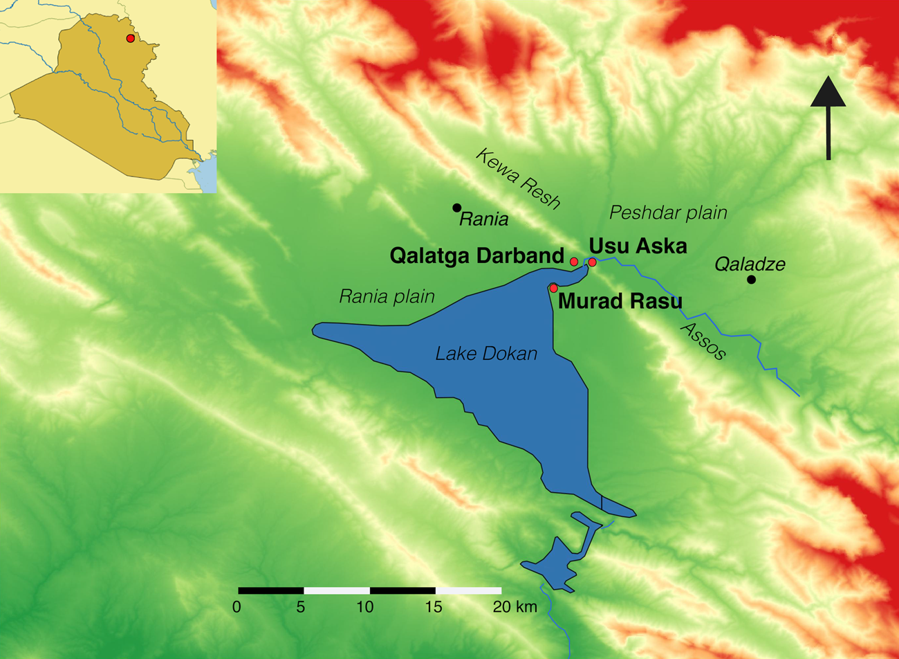
Fig. 1 Map showing the location of the Darband-i Rania (inset) and the three sites of the project at the northeast corner of Lake Dokan.
To date the project has conducted three seasons of fieldwork: the first season took place in September-November 2016 and the second season in April-June 2017; the third season, scheduled September-October 2017, was aborted after two weeks due to disruptions following the Kurdish Referendum on September 25th 2017. The team over these three seasons comprised Nawzad Abdullatif Abdulkarim, Mustafa Ahmad, Fidaa Almehho, Stefano Bertoldi, Ricardo Cabral, Jan Cibera, Amanda Dusting, Alberto Giannese, Tina Greenfield, Sami Jamil Hamarashid, Qasim Rasheed Hameed, Guy Hazell, Awaz Jihad Heda, Achilles Iasonos, Ramazan Qadir Ismael, Hemin Kawes, Osama Mohammed Khorsheed, Ewout Koek, David Kertai, Mohammed Jasim Abed Hasso, John MacGinnis, Bahzad Mohammed, Andy Miller, Kate Morton, Dilshad Abdulmutalib Mustafa, Halkawt Qadir Omer, Virág Pabeschitz, Lucas Proctor, Zaid Ghazi Saadallah, Christoph Schmidhuber, Mary Shepperson, Necmi Yaṣar, Craig Williams and Kovan Ehsan Yaseen.
History of the Rania plain from the Assyrian to the Sasanian periods
Archaeological developments in the Rania Plain and its emergence into history mirror the picture in the Kurdistan Region of Iraq more widely; we reprise here the sequence from the Middle Assyrian through to the Sasanian period. Middle Assyrian levels at Tell Basmusian (possibly to be identified as ancient Pakute at this time) and elsewhere suggest that the Rania plain fell under the control of the Middle Assyrian state.Footnote 2 The earliest this could have happened would be following the overthrow of Mittanni under Ashur-uballiṭ I (1353–1330 b.c.), but it could also have been significantly later. We can get some pointers from the vicissitudes of Idu, a state just to the west. Idu is not actually attested as under Assyrian control until the reign of Ninurta-apil-Ekur (1191–1179 b.c.), from which time it appears to have remained part of Assyria at least until the reign of Tiglath-pileser I (1114-1076 b.c.).Footnote 3 Idu subsequently threw off Assyrian rule and existed as an independent state for around 180 years, until its re-incorporation into Assyria under Adad-nerari II (911–891 b.c.) (Llop Reference Llop2013: 106; van Soldt et al. Reference van Soldt, Pappi, Wossink, Hess and Ahmed2013: 219–220).Footnote 4 It then remained part of the Assyrian empire until the end. We can suggest that a similar evolution befell the Rania plain. In terms of the Middle Assyrian administration, it appears that the Darband-i Rania (or possibly just Qaladze) marked the eastern limit of Middle Assyrian control. With the expansion of the Neo-Assyrian empire the border certainly moved eastwards, up to the chaîne magistrale of the Zagros. On the basis of the tablet discovered at Qalat Dinka, south of Qaladze, it has been proposed that the Peshdar plain was part of the province of the Palace Herald,Footnote 5 though this proposal is not without difficulties.Footnote 6 In any case, the Rania plain must have also remained part of the empire until nearly the end. The process by which Assyria lost control of the eastern part of her empire is as yet poorly understood. The trans-Zagros territories, the provinces established by Tiglath-pileser III and Sargon II, were probably lost in the course of the reign of Ashurbanipal. The provinces on the western side of the Zagros may have been able to hold out a little longer, but it is overwhelmingly likely that the Medes will have seized the Babylonian victory on the outskirts of Arrapha in 616 b.c., which resulted in the Assyrians falling back to the Lower Zab, as the occasion for co-ordinated attacks from the east. Indeed, in the entry for the very next year the Babylonian Chronicle records how “the Medes went down to Arrapha”.Footnote 7 Almost certainly their route, or one of their routes, must have taken them via the Darband-i Rania, and it may be imagined that it was at this time that an Assyrian fortress in the pass was overrun.
Following the overthrow of Assyria, the empire was divided between the victorious powers. The Babylonians took Mesopotamia proper as far north as Assur, the provinces to the east of this, and what is now modern Syria.Footnote 8 The Medes took the Zagros territories and, presumably, Assyria north of Assur. It is generally thought that Erbil fell to the Medes, an assumption certainly strengthened by the fact that the city is not listed among the possessions of Nebuchadnezzar and that Neo-Babylonian sources in general make almost no reference to the city. However, major questions remain with regard to the nature and extent of Median rule. East of the Tigris the border between Media and Babylonia was probably demarcated by the Lower Zab: the northern half of the Rania plain would then have been under Median control, and the southern half under that of Babylonia; this would make the interface at the Darband-i Rania of extraordinary interest. While it is not known how long the Medes maintained control over the area, a terminus post quem non is provided by an episode recorded by the Babylonian Chronicle, which narrates that in the ninth year of Nabonidus (547 b.c.), Cyrus marched with his army “below Erbil”Footnote 9–a phrase which must mean that he followed the Lower Zab–and which presumably indicates the territory was no longer under Median control. Eight years later, in 539 b.c., Cyrus conquered Babylon, bringing the Neo-Babylonian empire to an end. When the dust settled, the Zagros territories were definitively incorporated within the Achaemenid empire. Little is known of the region in the Achaemenid period, but in 331 b.c. it is likely that it is by this route along the Lower Zab and through the Darband-i Rania that Darius III fled to Media following his defeat at the hands of Alexander the Great at Gaugamela.
With the death of Alexander, the empire he had conquered fragmented. The eastern territories, including Mesopotamia, fell within the Seleucid empire. To date, almost nothing is known about the Rania region at this time.Footnote 10 For the south, Seleucid rule came to an end in 146 b.c. when Mithridates I invaded Babylonia, bringing it under the control of the newly expanding Parthian empire. At some point around this time northern Mesopotamia also came under Parthian control.Footnote 11 The erstwhile Arbelitis, now known as Adiabene, continued as a client kingdom within the Parthian empire,Footnote 12 though continually caught up in the power struggles between Parthia, Armenia and Rome. Following Ardashir I's coming to power in 224 b.c. the region then passed into Sasanian control.Footnote 13 The region has therefore been a zone of frontier interaction for a succession of empires and states–Assyrian, Babylonian, Median, Achaemenid, Hellenistic, Parthian and Sasanian–for a period of more than a thousand years. This is the setting of our investigation at the Darband-i Rania.
Exploration of the Rania Plain
While the Kurdistan Region of Iraq had, until the past decade, been relatively unexplored, the Rania plain actually forms an exception, as the construction in 1957–1961 of a hydro-electric dam at Dokan, at the southern end of the plain, was accompanied by an initiative of archaeological salvage excavations. The most notable of these are the Danish and Iraqi excavations at Shemshara, which discovered the palace of the Old Babylonian period, including an archive room containing over a hundred cuneiform tabletsFootnote 14; excavation of the large multi-period tell of BasmusianFootnote 15; and the uncovering at Tell ed-Daim (Gird-i Daim) of a fortified manor dating to the Achaemenid period (Al-Tikriti Reference Al-Tikriti1960; Curtis and al-Rawi Reference Curtis, al-Rawi, Kopanias and MacGinnis2016).
After a hiatus of some 50 years, work in the Rania Plain has resumed. Two important surveys have been conducted in the locality, firstly as part of the Sulaimaniya Governorate Archaeological Survey, directed by Jessica GiraudFootnote 16; and secondly the Rania Plain Survey, conducted jointly by Jesper Eidem on behalf of the Netherlands Institute for the Near East and Tim Skuldbøl of the University of Copenhagen (Eidem and Skuldbøl Reference Eidem, Skuldbøl, Kopanias, MacGinnis and Ur2015). The latter has been followed up by Eidem with a renewal of excavations at Shemshara (Eidem Reference Eidem, Kopanias, MacGinnis and Ur2015a) and the nearby site of Bardastee,Footnote 17 and by Skuldbøl with excavations at Bazmusian, Gulak and the twin sites of Bab-u-Kur.Footnote 18 In 2017, excavations were inaugurated at the Chalcolithic and Bronze Age site of Boskin, just east of Rania, by Dr. Jessica Giraud of the Institut Français de Proche-Orient (Director) and Johnny Samuele Baldi (Field Director). Documentation of a very worn relief cut into the rock on the northern side of the Darband-i Rania pass, carried out by Peter Miglus of the University of Heidelberg, has suggested that this may be tentatively dated to the Old Babylonian period.Footnote 19
The Darband-i Rania–also known as the Darband-i Ramkan––pass lies approximately 8 kilometres east of Rania, at the point where a gap between the Kewa Rash mountains to the northwest and the Assos mountains to the southeast allows the Lower Zab to flow from the Peshdar into the Rania Plain. This location now corresponds to the northeast corner of Lake Dokan. The three sites under investigation cluster in this northeast corner: Qalatga Darband dominating the western approaches to the pass on the northern side of the lake, Usu Aska in the pass itself on the southern side, and Murad Rasu on an erstwhile promontory also on the southern side, 2 kilometres to the west. All three of these sites have suffered severe damage, both from the lake and from other factors, and all three remain critically endangered, with further damage and destruction virtually certain. These considerations alone justify immediate action to investigate and record the remains as they now stand. But beyond this, there was another reason for choosing to explore these sites, as together they present a unique opportunity for investigating the occupation and defence of this strategic pass in the first millennium b.c.
Qalatga Darband
Qalatga Darband is a large open site dominating the northwestern approach to the pass. The location on the shore of Lake Dokan corresponds to what was once a terrace overlooking the northern banks of the Lower Zab; in antiquity the site commanded both the road and the river going through the pass. The strategic importance of the location is obvious, and the sheer size of the site, in excess of 70 hectares, reflects a massive investment. Knowledge of the site has however hitherto been very limited. The site was not formally recognised until 1973, when the local historian Abdulraqib Yusuf began to record the various traces visible on the surface. A brief assessment was made in 2013 by Jessica Giraud and the Sulaimaniya Governorate Archaeological Survey, involving the collection of diagnostic surface ceramics, preliminary analysis of which suggested the site had significant occupation in the Seleucid and/or Parthian periods, together with smaller occupations in the Sasanian and also Neo-Assyrian periods. Our own preliminary results suggest that the major occupation of the site is in fact Parthian, specifically early Parthian (mid-second to first century b.c.) a time period hitherto barely explored in this region.
Qalatga Darband is recorded in a variety of satellite images. Most important is a CORONA image from February 1960 (Fig. 2). In this image a large square feature is visible south of the main road and immediately south of a track (which still exists) running east-west across the site. The western city wall is also visible, and in addition a number of linear features that may represent walls of structures within the site but which are not sufficiently coherent to suggest actual plans. The site also features in other CORONA images, although not with the same level of detail, as well as in sequences from other satellite programmes, for example Quickbird, although once again not with a level of detail of use for understanding the configuration of ancient structures.

Fig. 2 Declassified CORONA satellite image, taken February 1960, showing the site of Qalatga Darband. A large square feature is clearly seen in the northern part of the site, immediately south of the dirt track; the western city wall is also clearly visible.
The fieldwork commenced with topographic mapping, which to date has mapped everything from the main road down to the lake, and up to (and a little beyond) the western fortification wall; in the east the topographic mapping proceeded up to the large compound and the industrial area. The remains north of the main road have not yet been mapped. We next commenced a programme of ceramic surface collection, which established the dating of the site to the early Parthian period (details of this below), and a survey of the large shaped stones strewn across the site. Just over 100 stone pieces were recorded, falling into the following categories: bases and weights from lever presses, carved ashlar blocks, pieces of columns (bases, capitals and cylindrical sections), pounding stones and roof rollers. The press bases are particularly distinctive; these are flat stones consisting of a main roughly circular part a little over 1 metre in diameter, with a groove all round the edge leading to an exit channel (Fig. 3); six of these were recorded. These are certainly the bases of oil presses and are of a type that is distinctively east Mediterranean.Footnote 20 It is of considerable interest that a very close parallel comes from Aï Khanoum.Footnote 21

Fig. 3 Olive press base from the surface of Qalatga Darband.
Another piece recovered from the site and currently in the garden of the Sulaimaniya Museum is a Corinthian capital with volutes either side of an acanthus (Fig. 4), which again has a close parallel in a capital from Aï Khanoum dated by Bernard to the first half of the second century b.c..Footnote 22
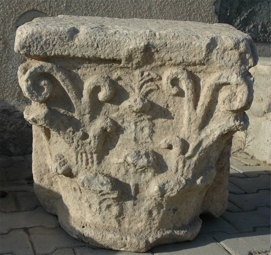
Fig. 4 Column capital from Qalatga Darband in the courtyard of the Museum of Archaeology in Sulaimaniya (Courtesy Abdulraqib Yusuf).
In the second season, an overhead UAV (drone) survey was conducted using a Phantom 4 Pro+ multicopter. Trench surveys were conducted at Qalatga Darband in Areas C, E and G, as well as at Usu Aska Areas B and C. Large scale aerial surveys mapped the entire site of Qalatga Darband, which was surveyed at a constant height of 100 metres from the ground in one flying session. Approximately 1100 photos were acquired and processed to obtain a detailed orthomosaic of the entire site. Due to the crop cycle at this time of the year (May) it was not possible to obtain a reliable DTM for this area. However, an unexpected bonus was that cropmarks were visible in a number of places. The analysis of these cropmarks was facilitated by processing through DStretch software using a number of different filters (Fig. 5). A GIS database was built using QGIS in order to trace the visible cropmarks at Qalatga Darband, as well as to provide an easy way to generate schematic plans of the archaeological sites.

Fig. 5 Colour enhanced ortho-image from the UAV survey of Qalatga Darband showing structures in the southern sector of the site, including a large structure with concentric square walls. The eastern corner of this building was investigated as Area H.
Excavation
Excavation was commenced in seven locations (Fig. 6). In Season 1, work took place in Areas A-F, in Season 2 in Areas C, E and G, and in Season 3 in Areas E and H. From the outset an integrated and holistic protocol for sampling and analysing ancient organic bioarchaeological data (animal and human bones, seeds, shells, charcoal, bitumen and phytoliths) was implemented. The preliminary analysis of the archaeozoological remains from the Sasanian burials is given below; more detailed reports on the evidence of diet, species preference, disposal, consumption, and distribution practices of animals and their by-products across the site will be given in future reports.

Fig. 6 Plan of Qalatga Darband showing the location of excavation areas. The dashed lines indicate modern tracks through the site.
Area A
Area A, located in the north of the site close to the modern road, was opened up in order to examine some architecture incorporating re-used stone weights and to recover material for dating. Evidence was found for two principal levels. The upper level of the remains breaking the surface turned out to be modern, very likely the remains of tenements built to house workers or equipment for tobacco farming in the 1970s or 1980s. Below this, and separated by a clear layer of accumulated deposits, were the remains of stone wall foundations which, based on a preliminary analysis of the associated ceramics, can be dated to the early Parthian period, i.e., the 2nd–1st century b.c. The small finds included a fragment of a baked clay archer figurine (QD-602, Fig. 7) and a gold-coloured glass bead (QD-624).

Fig.7 Fragment of a Parthian archer figurine QD-602 found in accumulation context A-010.
Area B
The aim of the work in Area B was to groundtruth the square structure visible in the Corona imagery. The remains uncovered, which comprised the stone footing for an outer wall 6 metres wide and parts of smaller structures on the inside (Fig. 8), together with associated evidence for metal-working and storage facilities, are consistent with a fort. Preliminary analysis of the ceramics suggests that these remains again date to the early Parthian period. It should be noted that fortresses of square design are a typical feature of the Parthian period, with examples found in Iraq at Khirbet Jaddalah (between Hatra and Nineveh), Nippur, Babylon, Kish and other places.Footnote 23 While it is not envisaged that the expedition will continue to excavate any very extensive portion of this fort, it is hoped that a plan of the interior may be recovered by geophysical mapping. Two pithos sherds with bitumen linings from Area B of Qalatga Darband were exported for research. Analysis of these by Adrià Breu-Barcons at the Scientific Department of the British Museum using multiple spectrographic techniques established that the source of this bitumen is from the Batman-Siirt region in southeastern Turkey.

Fig. 8 Plan of the stone wall foundations recovered in Area B.
Area C
The excavations at Area C aimed to investigate the western fortification wall, which runs from the edge of the lake up on to the slopes of the mountains to the north. A 3.60 metre stretch of the main wall was uncovered (Fig. 9). It was preserved to a height of 1.30 metres and built of large, irregular unworked stones between 20 and 50 centimetres across, laid in rough courses; five courses were fully exposed, with the top of the sixth visible at the bottom of the exposure. The resulting wall face is straight, regular and carefully constructed, with a slight batter. The wall is furnished with rectangular projections at regular intervals. One of these was also excavated. It measured a little under 7 metres wide, projecting out from the wall by around 5.20 metres. The chamber, which measured 4 metres across and 5.10 metres in length, was filled with occupation deposits and domestic features, indicating that it was used for habitation for a period of time. There was evidence for two surface lenses made of small stones. Into the upper one were set a small tannur, a baked brick hearth and a large, oval ceramic basin, the fill of which contained a large quantity of animal bone mixed with stones, potsherds and traces of ash; all these features hint at the domestic activities of the soldiers stationed in the bastion. All the material from the tower chamber dates to the Parthian period with little or no change between the top and bottom deposits. The northern side of the trench was extended eastward in a 3 metre wide strip to a total length of 34 metres. This was done primarily to investigate a feature on the CORONA image which appeared to be a second massive wall behind the first. However, no trace was found of this structure which, if it existed, must have been a shallow construction ploughed away since 1960 (when the Corona image was taken).

Fig. 9 Plan of the architecture in Area C.
Area D
Area D, in the southern part of Qalatga Darband, was selected for excavation due to the high concentration of baked brick and roof tile fragments lying on the surface. The goal of the excavations was to investigate the source of this rubble and any associated architecture. Removal of the topsoil revealed a thick level of rubble made of broken baked brick and roof tile in a matrix of broken mudbrick spreading across all trenches. This rubble layer lies directly over the remains of an underlying building with stone wall foundations preserved to just above the level of its white plastered floors (Fig. 10); a dirt fill covered these surfaces up to the height of the walls, and the layer of rubble lay directly on top of both the walls and this fill. Most importantly, the room fills and the standing architecture are devoid of the rooftile or baked brick fragments that typify the rubble. It is accordingly clear that the rubble layer is not in situ building collapse, but rather that the building was deliberately levelled and the rubble redeposited above these levelled remains. The reason for all this levelling was most likely to create a platform for the construction of the building whose remains are visible on the top of the small mound a few metres to the west. It is difficult to say much about the underlying architecture in Area D, other than than that it was a well made building with white plastered surfaces; it seems probable, but has not been demonstrated, that it was of sizeable proportions. The bricks measured 29–31 centimetres square, varying from 6 to 11 centimetres thick. The roof tiles comprised both main tiles and capping tiles, and a single fragment of an antefix rosette (QD-706) was also found; the system of tiling is discussed further below. There were no in situ ceramics on the excavated floors–the remains have the appearance of having been swept clean prior to the demolition–but ceramics in the overlying rubble were once again of the Parthian period.

Fig. 10 Plan of the architecture recovered in Area D.
Area E
Area E is located in the southern part of the site and constitutes a huge stone mound located approximately 100 metres east of the city wall. Excavation was undertaken to explore the nature and date of these remains. By the end of the second season an area of 20 × 12 metres had been uncovered, revealing part of a very substantial complex built of stone (Fig. 11). Four rooms (2–5) were revealed in whole or in part, together with a possible outside area (Room 1). Across this exposure the primary architecture and associated occupations can be dated to the early Parthian period. Following the abandonment of the building, the dilapidated remains were used for the interment of secondary burials in the early Sasanian period.
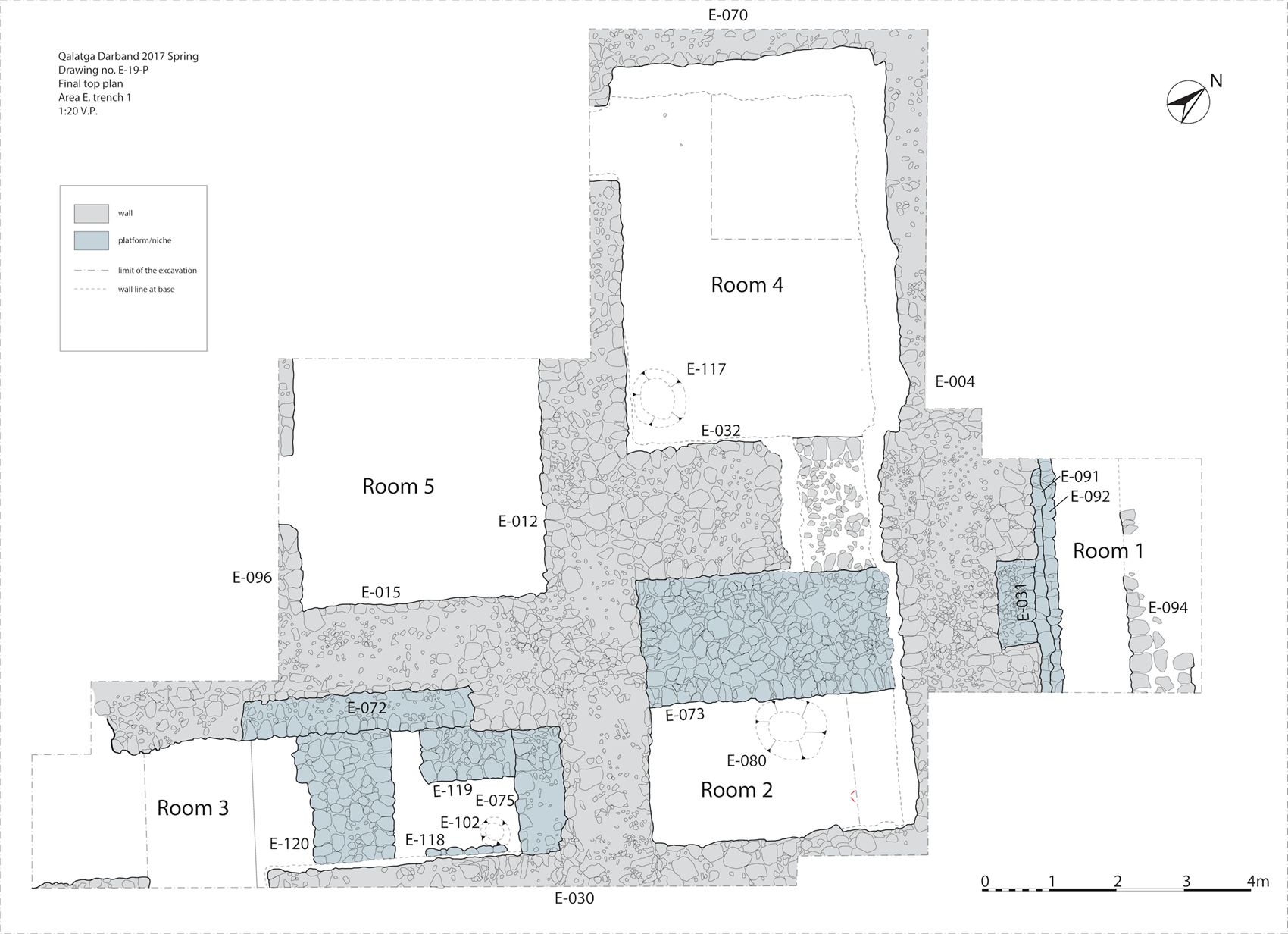
Fig. 11 Plan of the Area E monumental building as recovered by the end of Season 2.
Room 1
Room 1 is a space on the northeast eastern side of the excavation. While it is not yet clear whether this is part of a room or an area outside of the building, it is noteworthy that wall E-004 has a niche measuring 1.30 × 0.65 metres in its north-eastern face; traces of ash in the niche suggest that it once held lamps or torches. The stone fill of the room contained many animal bones, pottery sherds and metal fragments, as well as a copper-bronze ring (QD-834) and a coin (QD-889), which was, however, too badly preserved for identification.
Room 2
Room 2 is located near the middle of the mound and measures 4 × 4.20 metres. The upper fill of the room (E-011/023) consisted of stones in soil containing large amounts of completely disarticulated and very fragmented bones, together with jewelry, beads and coins (QD-806, QD-1212, QD-1213, QD-1259, QD-1277). Directly under this upper collapse was a layer of baked bricks and roof tiles (E-010) up to 35 centimetres thick. The bricks measure 28 × 28 × 6 centimetres. The walls (especially E-012) are very well preserved, with a number of patches of white plaster still in situ (E-042, E-043, E-051). Below E-010 was a dark brown compact clayey matrix of which the upper part (E-034) contained large amounts of roof tiles, charcoal, animal bones, pottery, nails and other pieces of iron. Immediately below this was a supra-floor layer consisting of a very ashy deposit (E-067) containing a lot of charcoal and a lot of pebbles, overlying a floor of red clay (E-074) and a stone platform (E-073) which bonds with the walls of the room, both plastered in white plaster. The ceramics from these horizons date to the early Parthian period (see below). Large fragments of three storage jars (E-057, E-058, E-059) were lying on the floor; these had been used to store white plaster and are one indication that the building was in the process of renovation when it was destroyed. Also on the floor were numerous fragments of sculpture, including an arm (QD-1169), a leg (QD-1210), a wrist (QD-1211), a foot (QD-1241) and the torso of a seated girl (QD-1250). Next to the platform, in the middle of the room an offering pit (E-080) was found with plaster trays and green residue at the bottom. At this stage the base of wall E-004 was visible and it was observed that it does not have a proper foundation, the stones of the wall just sit on virgin soil.
Room 3
Room 3 is a rectangular room measuring 8 × 2 metres, with niches in the northwestern and northeastern walls, which again show signs of burning. The upper fill consisted of a stone collapse (E-035, E-066), which again contained thoroughly mixed up and disarticulated bones (both human and animal), as well as jewelry, a bronze ring with an inlaid decorated stone (QD-809), colourful beads, fragments of glass vessels, four coins (QD-1126, QD-1154, QD-1163, QD-1167) and two almost complete vessels (an amphoriskos and a bluish green pot); all this material dates to the early Sasanian period (3rd–4th centuries a.d.). Below this collapse were two layers of compact brown clayey material, the upper one (E-047) slightly lighter than the lower (E-087). The suprafloor (E-090) below this was a thin ashy deposit containing sherds datable to the Parthian period, including parts of two small bowls containing yellow and pink paint, bones and another fragment of an alabaster statue, probably part of a leg (QD-1452). The actual floor (E-095) was a matrix of reddish clay and brick fragments. Below this, set between stone features, was another pit feature with lining and a plaster tray on the bottom and a fill containing animal bones.
Room 4
Room 4 is a rectangular room measuring 5 × 3.5 metres. The upper fill consisted of a stone collapse (E-052, E-055, E-045), which overlay a layer of compact, clayey material up to 65 centimetres thick (E-071) containing plaster fragments (including many with reed impressions, evidently from the ceiling) and scatters of animal bones. Near the bottom of this layer were further remains of statuary, including an almost complete statue of a young man (QD-1369), as well as the upper part of a foot (QD-1342) and the stump of a tree (QD-1363). These lay just above a supra-floor deposit of black ash (E-076) lying on a white plastered surface (E-084/88), which in turn sealed an earlier burnt suprafloor (E-089) with Parthian pottery scatters overlying a floor of red clayey material (E-100), just as in Room 2. In this room it is clear that following an original fiery event a white plaster surface was laid which was likewise covered in black ash.
Room 5
This is a room in the middle part of the mound measuring 8 x 4 metres. Excavation had only reached an early stage when the work had to be abandoned due to the events following the 2017 Kurdish referendum. Early indications are, however, that the upper stone collapse once again contains concentrations of disarticulated bones together with ceramics, jewelry and coins.
It appears that the Area E complex was deliberately infilled. In all the rooms excavated to date, the burnt suprafloor is overlain by a deposit of homogenous brick material up to 1 metre thick. These contexts cannot be collapsed mudbrick architecture as (1) there is no indication that the building utilised mudbrick, (2) they are too homogenous for mud brick collapse, and, most importantly, (3) they lie underneath the terracotta tile roofing collapse. The only possible explanation is that these contexts represent the deliberate infilling of the building. The dating of this action has not been established, but a terminus ante quem is provided by the Sasanian secondary burials.
Sasanian secondary burials
In at least four of the rooms excavated to date (Rooms 1, 2, 3 and 5), the upper stone collapse contained large quantities of disarticulated human and animal bones, in addition to jewelry (particularly earrings), glass, beads and coins. The coins date to the early Sasanian period, specifically to Ardashir I (223–240 a.d.) (QD-1277), Shapur I (240–270 a.d) (QD-1126, QD-1154, QD 1163, QD-1167), Ohrmazd I (270–271 a.d) (QD-1259), Bahram II (274–293 a.d) (QD-1212, QD-1213) and Shapur III (383–388 a.d) (QD-806). The only plausible interpretation is that these remains are reburials of skeletons and accompanying grave goods that had been relocated from their original deposition. It is overwhelmingly likely that these are Zoroastrian secondary interments. The animal bones were quite well preserved and show evidence of butchery. Preliminary analysis of these remains (Fig. 12) establishes the presence of an impressively broad range of species, including sheep, goat, cattle, horse, donkey, fallow and roe deer, dog, cat, birds and frog; the absence of pig is striking. The diversity of taxa is impressive for such a small sample. It is of interest to note that an exact parallel for this deposit is found at the site of Shar-i Qumis (ancient Hecatompylos) in northern Iran, where also the disarticulated remains of burials of Sasanian date are found redeposited in the ruins of a Parthian monumental building.Footnote 24

Fig. 12 Frequency of animal taxa in the Sasanian reburials.
Sculpture
The Area E building has yielded numerous pieces of sculpture. To date these include two very substantial pieces and numerous fragments.
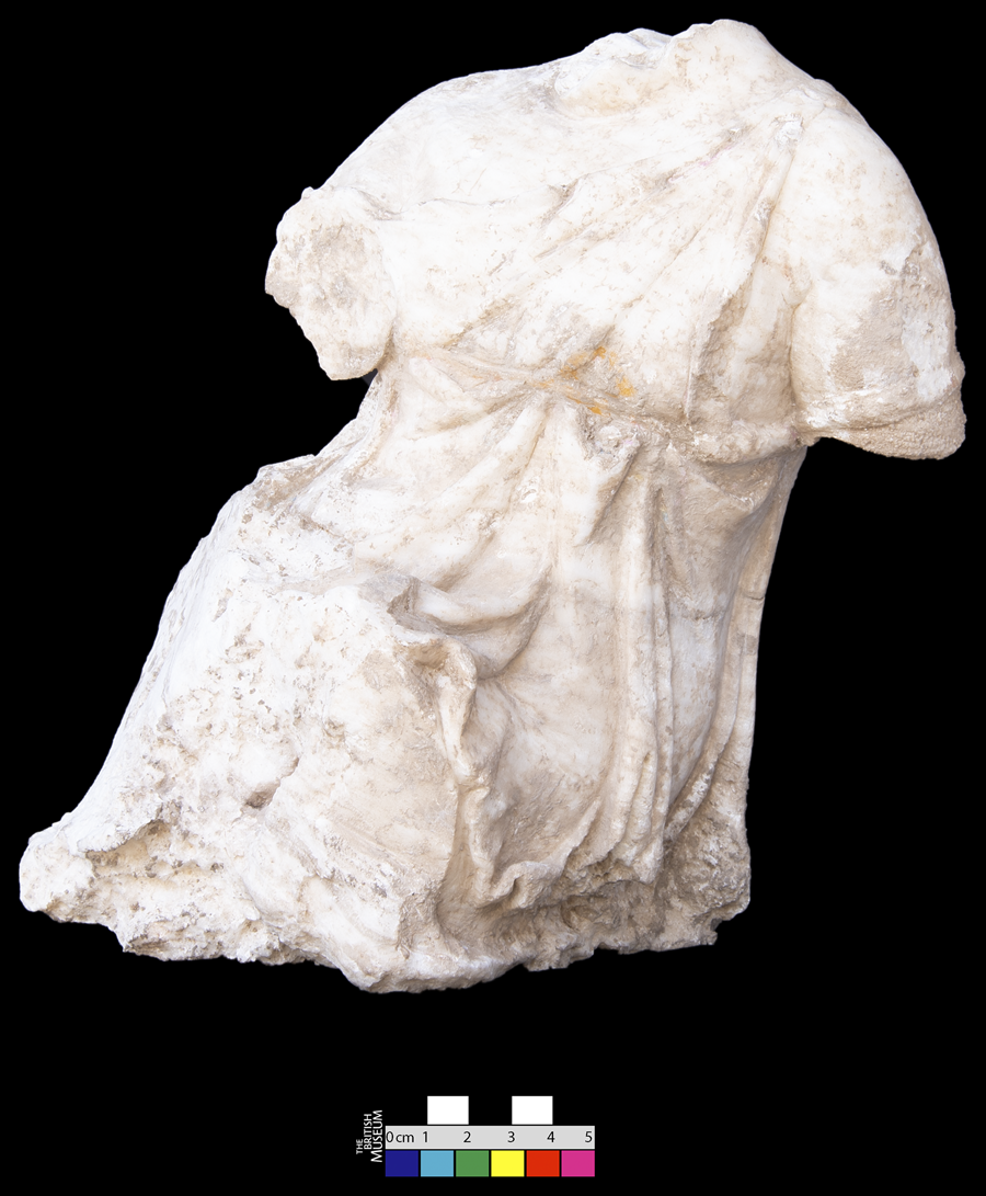
Quarter-size statue of a seated female (QD-1250)
This statue is carved of white marble of good but not exceptional quality. The preserved height is 36 centimetres, maximum width (across, not including left arm) is 20 centimetres, and maximum width (front to back) is 22 centimetres. The sculpture as preserved consists of the complete torso and the upper part of the arms (Fig. 13). The head and lower arms have broken off. The legs are also missing but were evidently made as separate pieces, attached by dowels into rectangular cuttings. The figure terminates as seated on a base approximately 18 centimetres square, roughly rendered on the underside, indicating the statue must have been set into a frame formed by the upper surface of the chair, which was presumably made of wood; the legs must then have extended in front of and below this chair. The figure wears a sleeveless chiton (dress). The garment is pulled over the left shoulder, where it was presumably secured, although there is no sign of a carved fibula, brooch or button, but the dress has slipped from her right shoulder, and is caught over her arm, which was originally raised. The folds of the garment are amply rendered, the workmanship is quite hard, with some of the vertical folds appearing rather linear and heavy, appearing like sashes rather than pleats of material. A thin belt runs high around the waist. Apart from the slots for attaching the legs, the statue has six other holes drilled in, located at the back of the left shoulder, between the base of the neck and the right shoulder, in the lower back and on the right hand side of the statue, presumably for attaching accoutrements or to secure the figure to another element or within an architectural setting. There are many places on the statue where traces of paint are preserved. The colours preserved are yellow, pink and purple. These pigments were analysed at the Scientific Department of the British Museum by Dr. Lucia Pereira-Pardo and Dr. Joanne Dyer using multiple spectrographic techniques, who were able to determine that the yellow is yellow ochre, the pink is madder and the purple is a mixture of pink madder and Egyptian blue.

Fig. 13 Statue of a seated female QD-1250.
The figure appears to be seated on the ground or some other surface, and the legs might have been stretched out, the right leg raised and bent, the left perhaps extended more. The left hand perhaps rested on the ground while the other was extended out, perhaps holding some kind of object. This type of statue and its scale suits a figure of a young girl; images of this type were set up in sanctuaries of deities associated with the protection of children such as Artemis and Eileithyia, but they might also have served as funerary sculptures. The lack of breasts also indicates that this is not an adult woman. When found in domestic contexts, such figures might have been part of genre scenes, for example children playing games or holding pets. Such a pose might also be appropriate for a figure being attacked, an Amazon maybe, or a woman/girl warding off the unwanted advances of an amorous pursuer, such as a nymph recoiling from a satyr.
Half life-sized statue of a naked youth (QD-1169+)
This statue was carved in fine white alabaster (Fig. 14). At the time of writing, the torso found on the floor of Room 4 (QD-1369) has been joined to the left lower leg (QD-1210) and the right arm (QD-1169), both found in Room 2. The right leg, left arm and head are still missing. Both hands and the left foot are also missing, though a right foot (QD-1169) carved out of what appears to be the same alabaster has been recovered. The current height of the statue, from bottom of the lower leg to the top of the upper arm, is 86 centimetres. There are three holes cut into the upper part of the back, again either for the attachment of accoutrements, whether wings or weaponry, or to secure the statue in its architectural setting.

Fig. 14 Statue of a naked male QD-1169+ .
The piece is beautifully made and finely smoothed. The figure is youthful and slight, with only minimal detailing of musculature. No pubic hair is carved, indicating that the subject was youthful, such as a young winged god like Eros or a heroic figure, perhaps Ikaros. Alternatively the figure might have represented a young athlete, raising his hand to place a victory wreath on his head. If the small holes in the figure's back were not for the attachment of metal wings, they might have been drilled to secure the statue in an architectural setting.
Roof tiles
Terracotta roof tiles (Fig. 15) were found in substantial quantities in Area D, where they are part of a levelling fill made from a previously demolished building, and in Area E, where it is clear that they are part of the in situ collapse from the roof of the monumental stone building itself. The size, type and material of the tiles are identical in both areas. They comprise flat tiles (Greek solenes, Latin tegula) and gable-like cover tiles (Greek kalupter, Latin imbrex); there is also one fragment of an antefix. The tegulae have a ridge projecting c. 4 centimetres upward on the upper edge in order to hold the tile above in place on a sloping roof. They also have ridges c. 1.5 centimetres high set in approximately 3 centimetres from the edge on each side on the upper face; these provide the frame to hold the imbreces in place. If one puts two of the tegulae next to each other, the imbreces fit on top perfectly. The imbreces themselves have straight sides with a pitched top. Many have a V sign on this sloping top, presumably a workshop sign. None of the pieces recovered to date preserve the whole width of the tegulae; the largest measurement we have is 38.5+ centimetres. There are, however, some complete imbreces. They measure 36–40 centimetres in length, 12 centimetres in width, and 8–9.5 centimetres in height, with walls 2–3 centimetres thick. The antefix is a fragment of a circular piece with a floral design and an original diameter of c. 12 centimetres.

Fig. 15 Roof tiles and antefix from Areas D and E.
These tiles belong to the Corinthian system.Footnote 25 Roof tiles have previously been found at Babylon in both the North Palace and at Babil,Footnote 26 and at Susa at both the Shaur Palace and the “villa à colonnes engagés”.Footnote 27 The Hellenistic temple at Icaros on Failaka yielded antefixes, and while not a single fragment of ceramic roof tile was found in collapse, pieces of burnt or fired tile were present in the masonry.Footnote 28 At Aï Khanoum, roof tiles and antefixes were recovered in the TreasuryFootnote 29 and in the temenos of Kineas.Footnote 30 Missing so far from the assemblage of ceramic building materials at Qalatga Darband are items such as drain pipes, guttering and vaulting tubes,Footnote 31 though there is one surface find (QD-008) which may be part of a terracotta frieze or similar architectural decoration.
Summary of Area E
As far as can be told at this stage, the Area E building was constructed in the early Parthian period on a virgin site and does not rest on the foundations of previous architecture or other archaeological deposits. The main use of the building came to an end in a fiery event, evidenced by layers of thick ash in all rooms excavated to date. Each of these rooms contained pieces of sculpture that had been smashed and scattered about. It appears therefore that the building was looted and destroyed by fire. The large storage jars containing lime plaster in Room 2, together with the smaller vessels containing paint in Room 3, as well as the upper plaster floor in Room 3 covered by a second ash layer, all suggest that a refurbishment of the building following this clastic event was in progress when a second burning took place. Subsequent to this, the building was not again used in its original function. However the utilisation of the structure did not come to an end. In every room there is a thick layer of homogenous clayey material with inclusions of mud brick, pottery and bones which can only be a deliberately laid fill, in places up to 1 metre high. The dense layers of jumbled stones from the collapse of the upper walls found in every room lie on this deliberate infill. In the early Sasanian period secondary burials were dug into this collapse, after which the site was abandoned.
Area F
Area F was a sounding carried out at a location where a fragment of a fine diorite bowl (QD-004) had been found during field walking. While no associated architecture was discovered, preliminary analysis of the ceramics recovered indicates that it included fine tableware, once again dating to the early Parthian period. The diorite bowl itself has an excellent parallel from Persepolis.Footnote 32
Area G
Area G is a 6 × 4 metre sounding located southeast of Area E, which was opened up in order to investigate some stone masonry discovered in the course of routine agricultural work. The principal architecture in the trench consisted of what appears to be a wall with an associated walkway, with a maximum width of 1.40 metres. The correct interpretation of these remains is not yet clear; whether they are, for example, part of a stoa remains to be seen. There were two significant small finds, a fragment of a lamp with incised decoration (QD 1519), tentatively dated to the late Hellenistic/early Parthian period, and a fragment of a Parthian rider figurine (QD-1500, Fig. 16), recovered from a disintegrated mud brick context G-003.

Fig. 16 Fragment of rider figurine QD-1500, displaying V-necked decoration with arms positioned on the waist.
Area H
Area H is located c. 120 metres to the south-west of Area E. Imagery from the drone survey clearly shows what appears to be a substantial feature with concentric walls measuring 37 metres square. In Season 3, in order to groundtruth the image and to recover preliminary information on the structure, a 7 × 7 metre trench was laid out at the eastern corner. Excavation did reveal, at a depth of 30–40 centimetres, remains of stone walls at exactly the locations expected. Work was however curtailed almost immediately after this due to the disruptions following the 2017 Kurdish referendum. One small find of note was recovered from amongst the rubble core of the northeastern section of wall H-003, a gold earring (or pendant) 4 centimetres in length with a small elongated loop at one end (QD-1900).
Dating
Charcoal samples were taken from a variety of contexts in Areas A, C and E in Qalatga Darband, all thought to be early Parthian in date. These were analysed using a scanning electron microscope by Dr. Caroline Cartwright of the Scientific Department of the British Museum, who identified the species present as pine, oak, hawthorn and pistachio. Selected samples have been submitted for radio-carbon dating, for which we await the results.
Ceramics from Qalatga Darband
A programme of surface collection was commenced at Qalatga Darband using the following method. A grid of 100 m squares was laid over the site. At each intersection of this 100 m grid, a 10 × 10 m square was laid out and all ceramics, both diagnostic and non-diagnostic, were collected (Fig. 17). These ceramics were then processed with two objectives: (1) to establish the dating of the site, both overall and in each square; and (2) to gain an insight into the density distribution of the surface scatter. The results were interesting on both counts. Firstly, the overall occupation of the site is uniform, the pottery collected was homogenous with regard to both wares and types, indicating a single major phase of occupation. Secondly, the density distribution did show some clear spikes in internal areas of the sites. It also threw up one more result, namely that the number of sherds outside of the wall on the western side fell off very rapidly to zero, undoubtedly implying that there was no occupation outside of the city walls, at least on the western side.

Fig. 17 Map showing the location of surface collection squares.
For Qalatga Darband, a preliminary study has been done for the ceramics of this main phase; the ceramics of later periods will be studied in the future.
Ceramic wares
The ceramic wares were classified using macroscopic assessment complemented by detailed observations with a strong magnifying glass. The distinction between each ware group was based primarily on differences in the fabrics, though also taking into account the method of manufacture. The variety of wares was defined by many factors, such as the nature of inclusions (mineral, vegetal, size, shape and quantity), fabric texture and surface treatment.
The pottery was classified into six main ware groups, each comprising numerous sub-groups. The main groups are:
QD100: Common wares
QD200: Fine wares
QD300: Coarse Ware – Mineral Temper (Cooking wares)
QD400: Coarse Ware – Vegetal Temper (Mainly Handmade wares)
QD500: Glazed wares
QD600: Slipped wares
Typology
A detailed methodological approach has been followed relating to the morphological aspects of the pottery types. This is based on studying each characteristic that defines whether a sherd is a type or a sub-type, factoring in frequency in combination with differences in shape and ware. This approach is applied to all parts of the vessel: rims, necks, handles, lugs, spouts, body sherds and bases. The detailed results of this work will be published in a future volume dedicated to the ceramics.
In what follows, the principal pottery types and forms will be presented in accordance with this schema. As already stated, this is work in progress. As very few complete vessels have been recovered from the site, the categorisation of the material is based on the types of the diagnostic sherds associated with the vessel forms that they might belong to. A total of 16,991 pottery sherds were collected during the excavation during the first two seasons at Qalatga Darband,Footnote 33 1,923 diagnostics and 15,086 non-diagnostics. The total weight of the collected ceramics was 505 kg, comprising 58 kg of diagnostics and 447 kg of non-diagnostics.
Common Ware
This is the predominant ware in the ceramic corpus, used to make almost all the everyday common vessels. The main feature of this ware is the dense admixture of sand in the clay (or fine to small size minerals of different colours), a distinctive feature for Late Antique (Hellenistic/Seleucid, Parthian and Sasanian) pottery in the region. The differences in the clays of this ware are based on the types and quantity of inclusions, as well as on the texture of the paste: sandy fabric, sandy with minerals (black, dark red, beige, white), sandy with chaff temper and white lime. The colours of pastes vary among reddish buff, reddish orange, reddish light brown, reddish brown and yellowish brown.
Storage Jars
The excavations yielded a large quantity of fragments of storage ware from all areas. All the fragments of this type exhibit sandy and gritty fabric in addition to thick section walls. Colours are homogenous and range among reddish buff, reddish orange, reddish light brown, reddish brown and yellowish brown. All forms exhibit the technique of folding the rim and then modelling the folded lips into different rim shapes: round folded rim (Fig. 18a), round folded band rim (Fig. 18b), round folded beaked end rim (Fig. 18c), thickened grooved rim (Fig. 18d), triangular folded rim (Fig. 18e) and others. The rim diameters range between 15 and 40 centimetres. Three types of bases are found so far with these storage jars: round bases, pointed bases (Fig. 18f) and tapered flat bases (Fig. 18g). No knobbed bases of the type known from this period (as for example at Tell BeydarFootnote 34) have yet been recovered. A remarkable feature is the coating of the inside of the storage jars with a (thick or thin) layer of bitumen, certainly indicating that they were used to store liquids (most likely oil or wine).

Fig. 18 Common ware storage jars, jars and pots from Qalatga Darband. Paste and diameters: a light brown, 23 cm; b reddish orange, 24 cm; c light brown, 24 cm; d light brown, 20 cm; e rosy reddish brown, 25 cm; f light brown, -; g reddish light brown, 4 cm; h greyish buff, 13 cm; i buff, 13 cm; j buff, 8 cm; k yellowish brown, 9 cm.
Jars and pots
A large quantity of sherds was recovered from jars made of all the sorts of common wares. The three fabrics most used are: (1) sandy fabric, (2) sandy fabric with small to medium angular or sub-angular minerals (often red, black, brown and white), and (3) a well-levigated fabric with gritty angular small to medium angular mineral temper. The colours of the first two vary among light brown, reddish brown, light reddish brown, buff and reddish buff, while the third fabric is always buff, yellowish buff or light reddish buff. A number of different rim types are found. All rims are folded; the most frequent types are the square folded rim with grooves on top and sides (Fig. 18h); the round folded rim with a tenon projecting from the fold forming grooves on both sides (15 different sub-types) (Fig. 18i); a slightly square folded rim with a groove on the inside for receiving a lid (5 different sub-types) (Fig. 18j), and a round folded rim (Fig. 18k). The most frequent bases are flat and ring bases.
Fish plates
Only a small number of fish plates were recovered from Qalatga Darband, mainly unglazed (just one glazed rim was found). The most common rim types are the hanging rim (Fig. 19a), the triangular folded rim (Fig. 19b) and the triangular folded grooved-on-top rim (Fig. 19d). These fish plates are locally made of a sandy common ware which normally has small white inclusions. The colours of the pastes vary among light brown, reddish brown, reddish buff and light buff.

Fig. 19 Fish plates and bowls from Qalatga Darband (all Common Ware except c). Paste and diameters: a yellowish buff, 14 cm; b yellowish buff, - cm; c Green Glazed Ware, yellowish buff, 14 cm; d reddish orange, 16 cm; e buff, 16 cm; f chaff tempered light brown, 15 cm; g buff, 20 cm; h greyish buff, 15 cm; i light brown, 17 cm; j buff, 21 cm; k reddish brown, 16 cm; l reddish orange, 20 cm; m yellowish brown, - cm; n light brown, - cm; o reddish buff, -.
Bowls
Many types of bowls are present in the pottery assemblage. Some types are inherited from the Mesopotamian Assyrian and Achaemenid cultural traditions, for example the round folded rim with carinated bowls (Fig. 19e) and the angular everted rim bowls (Fig. 19f). Other types relate to the Hellenistic traditions, such as the incurved rim (Fig. 19g), flaring pointed rim (Fig. 19h) / thickened rim (Fig. 19i) / grooved-on-top rim (Fig. 19j) and sharply incurved carinated rim bowls (Fig. 19k). The most frequent types are the incurved rim bowls and the flaring pointed rim bowls.
Two main fabrics are used to make these bowls: the fine fabric with tiny white inclusions and the common sandy fabric. Other fabrics used, but less frequently, are the sandy fabric with minerals and the sandy chaff tempered ware. The colours of the fabrics and surfaces vary among light brown, reddish buff, reddish orange and yellowish buff. The diameters of the rims range between 10 and 27 centimetres, in other words from small to large size bowls. Some of these bowls are coated with a thin reddish clayey slip on the external surfaces. This technique might be a local imitation of slipped Eastern Sigillata. Similar bowls were found at Tell Sheikh Hamad.Footnote 35 Another important feature which needs to be considered is the variety in the types of decoration found on the external surfaces. Most common are horizontal incised lines under the rim (Fig. 19l), sometimes with a series of small circles (Fig. 19h); a row of crescents, either confined between two horizontal lines (Fig. 19m) or without lines (Fig. 19n); incised vertical lines with looping endings (Fig. 19o), and others. All the latter decorations resemble the decoration on moulded bowls (the so called Megarian bowls) from locations in western Turkey such as Pergamon,Footnote 36 IoniaFootnote 37 and Daskyleion.Footnote 38
Jugs and Bottles
Different rim types were used for the jugs and bottles. They come in two different neck types, either upright or everted. The fabrics used are the common ware fabrics, and their colours resemble those of the jar fabrics. The most frequent rim types are the triangular folded rim (Fig. 20a), the round folded rim (Fig. 20b) and the folded grooved rims, either on top or on the sides (Fig. 20c-d).

Fig. 20 Common ware jugs, bottles and basins, and cooking ware pots, from Qalatga Darband. Paste and diameters: a yellowish brown, 9 cm; b yellowish brown, 8 cm; c yellowish brown, 8 cm; d buff, 9 cm; e yellowish brown, 30 cm; f light brown, 30 cm; g reddish brown, 17 cm; h light brown, 16 cm; i light brown, 14 cm.
Basins
The most distinctive features for basins are their 1–2 centimetre thick walls and the large (30–40 centimetres) opening diameters. They are usually made of gritty common wares, hand-made with a vegetal temper (HMPW, see below). The main types of rim are an opened slightly flaring thickened rim and folded rims (Fig. 20a-b).
Fine Ware
Fine wares are limited in the assemblage, apparently because fine (table) wares were made with common ware clays, although there are some exceptions. The most remarkable ware in this family is fine pure clay with occasional tiny to small white mineral inclusions, used for bowls and lamps, the former sometimes having a thin slip. Another ware in this group is the Eastern Sigillata A (ESA) ware. This is attested by only a very few sherds, imported from the west, but its presence is nevertheless of importance both for helping to date the assemblage as a whole and because of its indication of contact with the Levant.
The rarity of ESA ware at Qalatga Darband is understandable for geographical and cultural reasons. The majority of the sherds are body sherds, but there is also one small rim of a bowl and three ring bases (similar to the ring bases of platesFootnote 39); no complete plates were recovered. The fabric is very fine with no visible inclusions and the colours of the clays vary from light reddish buff to reddish buff. The pieces are coated with very thin orange to reddish orange and reddish slip on both surfaces. Similar sherds were found in level IV at Seleucia on the Tigris, dated to the second half of the second century b.c. (or the beginning of the first century b.c.).Footnote 40 In his study of the Eastern Sigillata A in the Eastern Mediterranean, Hayes has refined the early appearance of this ware to the (late) second century b.c., and it is very common in the first century b.c.; its production then lasted until the second/third century a.d..Footnote 41
Coarse Ware – Mineral Temper (Cooking Wares)
Cooking ware occurs in many varieties. They all share the hardness of the clay resulting from the high temperatures to which they were exposed, together with dark colour pastes. The wares differ mainly in the added inclusions: small to large dark gray angular flat minerals (always with compact thin sherd sections) and sub-angular to rounded minerals of different colours of small to large inclusions (with hard semi-compact fabric). Three distinctive fabrics were used for cooking pots: a hard compact fabric with angular small to large gray and black minerals usually burnished on external surfaces (reddish brown or reddish orange colours); a hard semi-compact fabric with sub-angular small to large white, red or brown mineral inclusions, often with a burned core (this fabric comes in light colours, usually yellowish or red orange); and a dense sandy or gritty fabric (normally light brown, reddish brown and reddish light brown in colour) similar to common ware fabrics but with a high proportion of grit. The use of common wares, sandy or gritty fabrics, to make the cooking pots is noteworthy. It seems that this was the principal ware used for making pottery, whether fine table vessels or cooking pots.
A significant quantity of sherds from cooking pottery was recovered, something which should give information on the region's cooking traditions. The most frequent forms are globular hole-mouth pots with thickened round rims (Fig. 20g), folded in-turned rims (mainly triangular) (Fig. 20h), and round folded rims (Fig. 20i).
Coarse Ware – Vegetal Temper
This ware, which is mainly hand made, is also limited in its frequency and restricted to certain types of storage jars, basins and bowls. The forms to which the few fragments recovered in the excavation belong could not be established; we hope that future work will elucidate this. The most remarkable feature of this sort of clay is the dense temper of white lime inclusions of all sizes from tiny to large, in addition to the admixture of vegetal inclusions, which varies in quantity. Moreover, as it is handmade, the potter did not tend to fire the pots in the same way as other wares, something evidenced in both the texture of the fabric and the different range of colours.
The absence of complete vessels makes identifying the forms of this ware difficult, but it includes some large basins and bowls, usually with thick walls and folded rims (often round and triangular).
Glazed ware
Glazed ware is a significant tool for dating the ceramic assemblage at Qalatga Darband. Only a few sherds were obtained from the excavation, but even so the results give us some pointers on cultural and chronological markers of the ceramic tradition. Two main types of glaze are found, green and blue. The texture of the glaze is always crackled, and it tends to wipe off the surfaces leaving yellowish tone colours in the case of green glaze, and white to whitish blue tone colours in the case of blue glaze. Glaze was usually applied to bowls and plates, less commonly to bottles, and generally on two types of fabrics, pure well-levigated whitish buff clay or a similar clay with tiny black and white mineral temper.
Green and blue glaze ceramics have been recorded at a number of sites dated to the early Parthian period in Iraq such as Nimrud,Footnote 42 Seleucia on the Tigris,Footnote 43 Nippur,Footnote 44 HatraFootnote 45 and Nineveh,Footnote 46 as well as at sites in Syria such as Tell Sheikh Hamad.Footnote 47 The majority of the glazed sherds from Qalatga Darband are body sherds, with a few fragments of rims and bases; these come mainly from Area E. The scarcity of glazed ware pottery at the site impacts on our knowledge of the associated forms. One small fragment of a triangular folded fish plate rim of fine yellowish buff fabric was found (Fig. 19c) which, though not (now) glazed, has a thin whitish blue slip on both the inner and the outer surfaces which may be the residual remains of a disintegrated blue glaze. Rims of some green glazed bowls were also found which are remarkable for the thickness of the glaze: three different rim types were found: a flaring round rim, an incurved carinated rim and a slightly incurved rim. The main fabric used for green glazed ware is a light buff fabric with small black mineral inclusions.
Slipped ware
The number of sherds recovered of this ware, which is characterised by a thin layer of normally cream to whitish buff slip on a reddish buff or light brown fabric (which may be sandy ware or have moderate small black minerals inclusions), was not high; it may be hoped that future excavations may provide us with more material to enrich our knowledge.
Ceramic chronology
Dating the pottery was not as easy a task as it initially appeared at the beginning of the first excavation season. The reason is the lack of excavation of contemporary sites in the region. We are as a result compelled to expand our search for parallels to northern Mesopotamia and Iraq and northwestern Iran. The apparent predominance of Hellenistic ceramic traditions, which we suspected at the outset, was misleading. The reason is that these traditions lasted for at least four centuries (from the fourth to the first century b.c.). The Hellenistic ceramic traditions may have been attractive to the Parthians, who adopted them into their ceramic repertoire. However, the eastern Greeks had themselves adapted Mesopotamian elements into their own ceramic repertoires. This led to the creation of regional ceramic traditions. Ceramic shapes from the western part of the Parthian empire show a blending between Mesopotamian and Greek (Hellenistic) forms. Therefore, it is no simple matter to separate the two traditions. This can be correlated historically as well; from the middle of the third century b.c. the Seleucid Empire was under pressure from the Parthians of Iran, an implication that there was early contact between the two cultures. And despite a temporary restoration of Seleucid authority in the eastern provinces by Antiochus III (223–187 b.c.), the struggle ended in complete Parthian control of Mesopotamia by 130 b.c.Footnote 48 We very much hope that the results of the radiocarbon analyses currently been run on charcoal samples from burnt surfaces in the Area E building at Qalatga Darband will help refine the dating of the corpus of Parthian pottery from the site.
However, despite the common Hellenistic ceramic tradition in the region, the occurrence of key characteristics in the ceramic assemblage is important for understanding cultural and chronological divisions and for refining the accuracy of our knowledge of distribution patterns. For instance, we can note that the absence in the assemblage from Qalatga Darband of black slipped ware and certain decorative elements such as dog-teeth and palmette stamps, which occur in levels 4–2 at Nimrud,Footnote 49 also the absence of stamped handles. All of these are characteristic of the Hellenistic repertoire in the 4th–2nd century b.c. On the other hand, the absence of certain markers typical of Parthian pottery of the 1st–3rd centuries a.d., such as diamond stamps and zigzag decoration, as well as many specific Parthian pot types, is an indication that our pottery does not belong to the late Parthian repertoire. Accordingly, we can tentatively suggest a dating for the pottery to the period from the late 2nd to the late 1st Century b.c. This is supported by the frequency of certain features which are present in our pottery such as the green glazed ware sherds, the locally moulded Megarian-like bowls and the sherds of Eastern Sigillata ware. It is hoped that future research, including an input from the results of radiocarbon dating, will refine these results.
Besides the Parthian period, there is evidence for two other periods at Qalatga Darband, specifically from Area E: Early Sasanian, confirmed by coins dating to the third and fourth centuries a.d. (see above); and Islamic, provisionally dated to the 10th–12th /13th centuries a.d. on the basis of the occurrence of a number of green sgrafitto and yellow glazed sherds of a type well known in the region.
In conclusion, little is known about the Early Parthian ceramics in this part of Iraq. This stands in contrast to the situation elsewhere, for example Iran, where we have the work of scholars such as E. HaerinckFootnote 50 and others. In the absence of any other major excavated Hellenistic and early Parthian sites in the region, the ceramic assemblage from Qalatga Darband is of exceptional importance. The analysis of this corpus will not only enrich our knowledge of the ceramic traditions of this period both in the Kurdistan Region of Iraq and in northern Mesopotamia more generally, but will also allow it to be studied in the context of the material from sites such as Nimrud,Footnote 51 Abu Sheetha,Footnote 52 HatraFootnote 53 and Seleucia on the TigrisFootnote 54 in Iraq; and Tell Beydar,Footnote 55 Tell Halaf,Footnote 56 Tell Arbid,Footnote 57 Dura EuroposFootnote 58 and Tell Sheikh HamadFootnote 59 in Syria.
Murad Rasu
Limited investigations were carried out at the site of Murad Rasu, southwest from Qalatga Darband across the waters of Lake Dokan. The site consists of a small mound with a lower extension in the fields on the southern side. In antiquity, and until the construction of the Dokan Dam, this location was a promontory overlooking the Lower Zab. The mound has been severely eroded by the fluctuating water levels of the lake and much of the northern sector of the mound has already been destroyed and fallen into the lake. Topographic survey revealed that the mound has in fact been cut in half by the lake, exposing an extraordinary section almost 100 metres long through the middle. The surface collection carried out by the Sulaimaniya Governorate Archaeological Survey in 2013 indicated that Murad Rasu has occupations from the Early Bronze Age through to the Late Islamic period; a principal objective for us was to see whether the site could yield a sequence from the Assyrian through to the Parthian period.
Two operations were carried out at Murad Rasu. In the first season a 5 × 2.5 metre trench was laid out to investigate the burnt remains of architecture–mud brick walls, a burnt floor and burned brick–visible in the side of the mound immediately by the lake side (Fig. 21). Six archaeological phases were identified. Phase 1 represents the modern activities occurring at the site, including post 1950s water erosion and deposition caused by the fluctuating water levels of the lake. Phase 2 was a mudbrick wall or platform, representing the most recent of the ancient structures exposed within the trench. The next three phases all relate to the architecture visible prior to excavation. Phase 3 was an extensive destruction horizon consisting of a distinctive layer of thick orange-brown mudbrick collapse composed of large quantities of burnt mudbricks, some of which were complete, measuring 40 × 40 × 9 centimetres. The bricks were quite fragile and it appears they had been burnt during a fire rather than purposely baked. Beneath the burnt-brick layer was a thick layer of black and purple sticky silty clay with frequent charcoal pieces. This layer represents the destruction of the roof or ceiling that had fallen during the burning of the building. Phase 4 was an intermediate phase of accumulation between the mudbrick collapse and the destruction layer above and the floor or surface of the building/room below. As this layer was quite thick and undulating it probably represents accumulation or room fill formed during the abandonment of the room before the destruction occurred, rather than an actual occupation layer. Phase 5 is the mudbrick walls themselves, which form a room c. 3 metre wide. The floor itself was composed of a yellowish light brown silty clay that varied in thickness from 2–5 centimetres. Phase 6 was the remains of occupational material laid down prior to the construction of the building, possibly pit contents. Preliminary analysis of the ceramics recovered during the excavation suggests a mix of early to middle Bronze Age material.

Fig. 21 North-facing section of Murad Rasu, Area A, showing the extent of the mudbrick collapse and destruction layers.
The second operation was a 4 × 4 metre trench located on the slope south of the highest point of the mound, excavated over a period of 10 days during Season 2 and designated Area D. The aim of this operation was to see whether it was possible to recover a ceramic sequence for the Assyrian to Parthian period. After removing the topsoil, the trench yielded remains of two principal phases, firstly some stone walling possibly dating to the Sasanian period, and below this a number of pits cut into virgin soil of apparently Parthian date.
Ceramics from Murad Rasu
The two short seasons of excavation at Murad Rasu yielded a quantity of pottery that, while limited, was sufficient to cast some light on the stratigraphy and history of the site. A total of 1,209 sherds was recovered, 219 diagnostic and 990 non-diagnostic.Footnote 60 Seven occupational phases were recorded, ranging from the fourth millennium b.c. until the Late Islamic period. A significant quantity of pottery dated to the fourth millennium b.c. (Late Chalcolithic 3–5) was obtained from the excavations carried out in the first season in Area A. This included Beveled-Rim bowls, including some complete examples, as well as other vessel forms dating to the period (Fig. 22). Similar jars and pots dating to this period have also been found at Gird-i Qala in Chamchamal.Footnote 61 During the surface collection of the site, fragments of jars and jar-stands dated to the Early Bronze and Middle Bronze Ages were found.

Fig. 22 Ceramics from Murad Rasu: a Bevel Rim Bowl, reddish light brown, diameter 16 cm; b Burnished Biscuit Ware, reddish light brown, diameter 7 cm; c Painted Biscuit Ware, red paint on light brown fabric, diameter 17 cm; d Common Ware, vegetal tempered light brown, diameter 25 cm.
For the later periods, the similarity in both fabric and vessel type of the sherds of the Hellenistic and Early Parthian periods collected both during the survey and from the excavation, with forms including fish plates, bowls (especially incurved rim bowls) and jars, to the pottery of Qalatga Darband is striking, and the dating must be the same. A few sherds of gritty fabric dated to the Sasanian period were found. Among them sandy greenish tone buff fabric sherds bear stamped decoration. This decoration is common in this period in the region (for example, among the pottery found at Tell Sitak).Footnote 62
The uppermost levels at Murad Rasu are mixed and disturbed by modern plough action. A few Late Islamic sherds were collected from the surface, including turquoise or bluish green glazed sherds and sherds of compact cooking ware. The sherds are similar to the late Islamic glazed and cooking pots commonly found in the region; parallels can be found in the results of the Sulaimaniya Governorate Archaeological Survey in the Rania and Peshdar plains. This dating is also supported by the presence of Ottoman pipe fragments.
In summary, the work at Murad Rasu has demonstrated the presence of remains from the Uruk period, the third millennium b.c., and the Parthian, Sasanian and Ottoman periods. However, the objective of recovering an Assyrian to Parthian sequence was not achievable, at least in the areas investigated.
Usu Aska
Usu Aska is the name of a site located actually in the Darband-i Rania pass, on its southern side. The site comprises two distinct elements, a promontory at the northern end of the site, which is sometimes an island due to the rising waters of Lake Dokan (Fig. 23), and the remains of a massive fortification wall stretching from near this promontory most of the way towards the modern bridge. These were investigated as Area A and as Areas B and C, respectively (Fig. 24). Work at Usu Aska was carried out in all three seasons to date.

Fig. 23 The northern part of Usu Aska, the island reconnected to the mainland by the fall in lake water level.

Fig. 24 Orthoimage of Usu Aska showing the location of excavation areas.
Area A
Investigations in Area A were carried out in Seasons 1 and 3. At the beginning of the first season this part of the site was still largely under water, the unsubmerged part forming just a small island. It was reported that earlier in the year the site had been completely inundated, with the water reaching c. 2 metres above the top surface. As the season progressed and the level of the lake fell, the area of the island increased, and by early October the island was connected to the mainland by a small isthmus. The site is currently occupied by a garden (c. 8 × 8 metres) and a small structure (c. 5 × 2 metres) with a concrete floor and a metal superstructure. The garden was without vegetation, except for its edges where trees had been planted. Only the tallest of these trees survived the flooding. The garden is surrounded by a small perimeter wall c. 20 centimetres high placed on a similarly high foundation of concrete blocks. More substantial landscaping took place around the lower parts of the site, where an elaborate terrace has been constructed. The excavation in Season 1 started as a 5 × 2 metre trench, expanded in stages to end up with an area of investigation measuring 6.5 × 6.5 metres. The excavation uncovered five phases excluding the garden layer, which was devoid of archaeological material.
The oldest level excavated (phase 5) was the most substantial. The area excavated presents a very dense concentration of masonry. Nine separate walls crowd this small space, with only small amounts of associated floor surfaces (Fig. 25). All phase 5 walls are constructed with stones and are only preserved up to two or three courses high. The preserved walls probably represent the stone bases on which mudbrick or pisé superstructures would have stood. Most of these structures can be grouped as phase 5b, with two additional sub-phases represented by structures that are either somewhat younger or older, but closely connected with the main phase. Phase 5 can be dated to the Iron Age on the basis of the associated pottery and is very likely Assyrian. No substantial finds were associated with this phase. The remains preserved of phase 5 are complex and a complete interpretation is not yet possible. In order to properly understand these remains, a larger area needs to be opened up and, where possible, taken down to a greater depth; the archaeological depth of the site remains unclear.

Fig. 25 Phase 5 walls in Area A, on the island at Usu Aska, as exposed in Season 1.
After the end of phase 5 and the erosion of its mudbrick superstructures (phase 4), the top of the remaining stones formed an external surface (phase 3) on which debris accumulated over the centuries. Three fragmentary walls can be associated with a poorly preserved Ottoman level (phase 2) created within and on top of this outside surface. The small finds associated with this level include clay pipes, fragments of glass bracelets and a metal spear. The upper levels of the site are modern and can be associated with the construction of the garden. In Season 2, the high level of the lake meant that it was not possible to work in Area A again at that time. We accordingly turned our attention to the massive stone feature to the west, investigating it in two locations, Areas B and C.
Area B
Area B is located towards the northern end of the preserved mass of the fortification wall. The excavations carried out in the course of Season 2, in a trench eventually measuring 15 metres east-west and 11 metres north-south, revealed evidence for three principal occupations. Firstly, walls at and just below the surface appeared to be the remains of structures from the Ottoman period. Secondly, a Parthian presence was attested by a grave (B-039), as well as by small concentrations of Parthian pottery nearby. The grave has a well built stone lining, preserved up to 25 centimetres high, into which had been placed a terracotta coffin (B-051). A storage jar lying above this was evidently part of the grave, though whether part of the construction or as associated goods was not clear. Removal of the collapsed baked pottery lid of the coffin revealed a badly preserved skeleton placed on its side with the head at the eastern end, facing west. The arms appear to have been slightly flexed, with the hands in the pelvis area, where a copper bronze ring (UA-237) was found. The skull was badly crushed, nevertheless it was clear that a coin (UA-233, Fig. 26) had been placed in the head area. The coin dates to the Parthian king Orodes II (57–38 b.c.). The obverse shows the king's head in profile, wearing a tasseled diadem; the reverse bears a Greek inscription saying: ‘Arsaces the King of Kings, beneficent, the just, the manifest, friend of the Greeks’.

Fig. 26 Coin of Orodes II from grave B-039 at Usu Aska.
The third phase present in Area B is Assyrian. The main fortification wall is damaged in this location but the remains are nevertheless very substantial. The wall is a massive construction built of huge blocks in the same manner as the stretch uncovered in Area C (see below). The overall width of masonry preserved is in the order of 6 metres and the elevation is in excess of 5 metres. Towards the eastern end of the section investigated is a rectangular feature measuring approximately 4.85 × 3.2 metres and comprising very large stones (some over a metre across), which does not appear to be random fall and which may be the base of a tower. The eastern side of this feature was marked by a revetment. A section of architecture on the inside of the wall was also exposed. In the time available three rooms were excavated in whole or part, together with part of a corridor. The walls range from 50 to 70 centimetres wide and are built of irregular small and medium sized stones, dry built with no mortar but with cavities filled by small stones. The finds on the floor and from the material above included a needle, an iron-blade, an arrowhead, iron slag and two iron-nails. A burial with a skeleton in a fragmentary state appears to be Assyrian.
Area C
Area C is located at the far southwestern end of the site, at the point where the fortification wall turns towards the slopes of Mount Assos. Investigations were carried out here in Seasons 2 and 3. Cleaning the partially fallen masonry along the western slope revealed the remains of a massive walling system (Fig. 27), exposing five courses of very large stones. This wall, which at this point is designated C-014, extends c.130 metres to the north, corresponding with wall B-056 in Area B, and for a further 80 metres more sporadically on towards Area A. It has not yet been demonstrated that the wall joins the remains at Area A, though this does seem probable. The wall is 6 metres wide and has been exposed up to 6 metres in height, although the base has not yet been reached. It is not yet clear whether there was a mudbrick superstructure above the stone walling system. It is quite possible that the whole outer defensive wall was constructed from stone, which would in turn suggest that the walls would have originally been much higher. Pockets of white plaster found between the large stones on the outer face suggest that the wall may have originally been plastered. The cleaning also revealed a second less substantial wall (C-017) running along the outer face of C-014, constructed of medium size stones and preserved two to three courses high. While speculative, it is possible that this is a walkway leading down the face of the main wall, from a now lost gate, in order to access the river below.

Fig. 27 View of Area C showing the main fortification wall C-014 and the additional wall C-017 on its outer face.
In the inside corner of the main wall, removal of topsoil exposed three burials of Parthian date. These were cut into a level that had a pit and also a burnt layer which contained a near complete Hellenistic two-handled jar with rosettes stamped on the neck and shoulder; it is possible that this is part of a cremation burial. Below this, part of a structure was revealed consisting of an east-west aligned wall with an associated stony surface and a tannur. We provisionally believe that this level may be Assyrian; a poorly-made cylinder seal of white stone with a rough linear design (UA-315, Fig. 28) came from the compact layer above this.

Fig. 28 Cylinder seal UA-315.
Ceramics from Usu Aska
During the first two seasons of excavation at Usu Aska, a total of 5,105 sherds were recovered, 612 diagnostics and 4,493 non-diagnostics. Six occupational phases have been recorded. Firstly, there were a number of Neo-Assyrian forms, including flaring or incurved bowls with a variety of rim shapes, mainly folded, occasionally with a groove on the lip (Fig. 29). There were also sherds of thin carinated beakers. The most striking feature in the fabrics of this period is the dense admixture of vegetal temper, in addition to the high proportion of white lime mineral inclusions of different sizes.

Fig. 29 Ceramics from Usu Aska, all Common Ware, temper, paste colour and diameter: a limestone, light greenish buff, 25 cm; b limestone, reddish buff, 20 cm; c sandy, light brown, 22 cm; d sandy, light brown, 29 cm.
A few pottery sherds dated to the Hellenistic period have been found in the upper levels of the site. A very distinctive piece from Area C with two handles and stamped decorations can probably be dated to the 3rd or 2nd century b.c. A collection of sherds similar to Qalatga Darband's pottery should be dated to the Early Parthian period (1st century b.c.). Among these are a few green glazed sherds of greenish buff fabric with small black mineral inclusions, and fragments of bowls of a sandy light brown fabric similar to the main common ware fabric at Qalatga Darband. The discovery of a Parthian coin in a grave dated to the reign of Orodes II (58–37 b.c.) may give a pointer to the dating of this material.
Sherds dating to the Sasanian period were present in the uppermost mixed levels of Area A. Several sherds of large storage jars were found, some bearing the backbone decoration characteristic of this period; many complete large storage jars bearing this decoration may be seen in the Sulaymaniyah Museum. In addition to these storage jar fragments, a few sherds of a turquoise glazed pottery dating to this period were also found in the excavation. A few late Islamic sherds were found directly below the surface. These include fragments of porous water jars, some yellow glazed sherds of a dark buff fabric, and a few pieces of pipes made of a fine clay with a red slip.
In conclusion, the excavation in Area C at Usu Aska has identified that this is the southwest corner of a massive Neo-Assyrian fortress. A period of abandonment followed the last phase of Assyrian occupation, then the site was used as a burial ground in the Hellenistic and early Parthian periods.
Conclusion
We finish with some historical reflections. In the site of Qalatga Darband we have a fortified settlement of the early Parthian period defending the western end of the Darband-i Rania. Why was this settlement created, why there, and when was it built?
A first reflection is that a fortified point at this location makes best sense in the context of the early westward expansion of the Parthian empire, specifically the period from when Mithridates I absorbed Media (c. 149 b.c.) but before northern Mesopotamia was brought under Parthian control (141 b.c. at the earliest, possibly somewhat later). By this model the Darband-i Rania would have been, for a time, the western border of the Parthian empire. The question then is, what state lay to the west? The obvious answer is Adiabene, and we would therefore propose that at the Darband-i Rania we have the eastern border of Adiabene, at least at this time. In fact, even after Adiabene came within the orbit of Parthia, it was as a client kingdom, and the border may well still have been preserved at this location.Footnote 63
That said, a further reflection can be made. Even if the genesis of the fortification of the Darband-i Rania lies in the period when the westward expansion of Parthia came up to the pass, it is entirely possible that the use and concept of the installation may have been impacted by subsequent political and military developments. In this regard, the discovery of a grave at Usu Aska with a coin dating to Orodes II (57–37 b.c.) is extraordinarily suggestive. Orodes II is the king during whose reign the Parthian army massacred the Roman legions at the battle of Carrhae. Was the massive intensification of the defence of the Darband-i Rania undertaken in the wake of Carrhae?
Some support for this suggestion may come from the disposition of the remains at Qalatga Darband. Specifically, why is there a large square fort inside the already fortified zone of the site? A plausible answer could be that the square fort was the original Parthian installation guarding the western approach to the pass, subsequently expanded into the much more comprehensive defensive system represented by the western fortification wall; that is to say that the square fort dates to the mid second century b.c. (in all events post 141 b.c.), and the expanded site to a century later (in all events post 53 b.c.). By this analysis, the expanded fortification of the Darband-i Rania would have taken place in direct response to the rising threat from Rome.
Turning to Murad Rasu, the small operations to date have established that the site has remains from at least the Uruk period up until Ottoman times. Substantial masonry above the excavated third millennium b.c. material would appear to be part of a platform of a monumental building. Of the three sites investigated, Murad Rasu is the only one which shows evidence of a long occupation over many periods. However, we have not, to date, succeeded in our primary aim of recovering a ceramic sequence from the Assyrian to the Parthian period.
Lastly, at Usu Aska evidence is emerging for the presence of an Assyrian fort of massive proportions. With walls surviving 6 metres high and 6 metres thick running the full length of the southern side of the pass, this must have been an immensely powerful installation. The strategic importance of the location does not need emphasis. In the Middle Assyrian period, regional survey suggests that the Darband-i Rania may have marked the eastern border of the empire. In the Neo-Assyrian period the frontier moved further eastward and the pass became an internal control point within Assyrian territory. As the end of Assyria approached, however, and the empire began to crumble, the border moved back towards the west, and it cannot be doubted that at some stage the Darband-i Rania was again on the frontier. As yet, exact dating is not available for either this expansion or this contraction. But for the latter an absolute cut-off must be 615 b.c., when the Babylonian Chronicle records, among other things, the Medes descending on Arrapha.Footnote 64 It is overwhelmingly likely that the route through the Darband-i Rania was one of the ways by which they came. The forcing of the pass must have been contested fiercely and we can imagine that it was the scene of ferocious fighting. It is to be hoped that future work at Usu Aska will yield material witness to these dramatic events.