Introduction
Western Iran has long been recognised as one of the key regions of the Neolithic Middle East (Braidwood Reference Braidwood1960a, Reference Braidwood1960b, Reference Braidwood1961; Braidwood et al. Reference Braidwood, Howe and Reed1961; Darabi, Reference Darabi2015; Darabi et al. Reference Darabi, Fazeli Nashli, Naseri, Riehl, Young, Matthews and Fazeli Nashli2013; Matthews et al. Reference Matthews, Mohammadifar, Matthews and Motarjem2010, Reference Matthews, Matthews and Mohammadifar2013a, Reference Matthews, Mohammadifar, Matthews, Motarjem, Matthews and Fazeli Nashli2013c; Matthews and Fazeli Nashli Reference Matthews and Fazeli Nashli2013; Mortensen Reference Mortensen2014). Past research has provided us with a much more complete and comprehensive archaeological record from this period than what is available from elsewhere in Iran. Although the number of settlements identified is not overwhelming, sites investigated in this region have added tremendously to our understanding of the Neolithic period in Iran.
The study of Neolithic settlements within this region yields much important information on social and economic aspects of ancient life, food production, the formation of seasonal and permanent settlements, and the emergence of pottery production, expanding our limited knowledge about the Iranian Neolithic. Notwithstanding the considerable increase in archaeological field work and surveys in recent years, the number of known Neolithic sites in western Iran is markedly lower than what is seen for later periods. Most of our knowledge of Neolithic settlement organization and material culture derives from excavations at a handful of sites, e.g., Asiab, Ganj Darreh, Guran, Sarāb, Abdul Hosein, East Chia Sabz, Sheikhi Abad, Chia Jani, Genil, Qasemi, and Qaleh Kamanbag. All of these sites are found in the Central and East Zagros regions (Darabi et al., Reference Darabi, Richter and Mortensen2018; Matthews et al. Reference Matthews, Mohammadifar, Matthews and Motarjem2010, Reference Matthews, Mohammadifar, Matthews, Matthews, Matthews and Mohammadifar2013b; Mortensen Reference Mortensen2014; Mortensen and Smith Reference Mortensen and Smith2014; Smith and Mortensen Reference Smith and Mortensen1980; Pullar Reference Pullar1990; Smith Reference Smith1990). As a consequence, archaeological research has generally tended to disregard the study of Neolithic settlements in the foothills of the Western Zagros, except for studies of a few recently identified sites (Biglari et al. Reference Biglari, Deo, Padhan, Bayrunvand and Davoudi2013; Mansouri and Mansouri 2015), even if it is clear that borderland areas between the Zagros and Mesopotamia were crucial to the emergence and interaction of early Holocene settlement systems.
Additionally, the distribution of key ceramic markers such as Zagros Standard Ware has revealed to us a vast cultural region extending from the Central Zagros to Northern Iraq, of which we know precious little. Logically, there should be comparable finds from sites located between Jarmo and Tamarkhan in Iraq and in the Central Zagros in Iran. These points highlight the importance of the region of Sar Pol-e Zahāb for the study of the Neolithic in the Middle East. Consequently, the objective of this study is to introduce a number of recently discovered Neolithic sites in the western Zagros foothills and to illustrate their importance to the study of the Iranian Neolithic (Fig. 1).
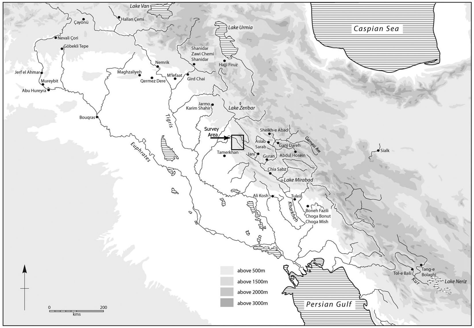
Fig. 1. Location of the study region and key Neolithic sites in Western Iran and Mesopotamia (after Matthews et al. Reference Matthews, Mohammadifar, Matthews, Matthews, Matthews and Mohammadifar2013b: Fig. 1.1)
Further research on the nature and distribution of Neolithic sites in this crucial region is an urgent matter, both in order to further explore early settlement organization, animal and plant domestication, and in order to catalogue and properly document the archaeological heritage from this period. As surveys in the Western Zagros foothills indicate a generally modest number of Neolithic settlements in the area, the sites presented here provide us with crucial information on the cultural ties between the Eastern and Western Zagros and Mesopotamia.
The Natural and Geographical Landscape of the Region
The lands of Sar Pol-e Zahāb comprise an environmentally rich and geographically imposing landscape, located in the western foothills of the Zagros astride the Great Khorasan Road and west of Kermanshāh province. The region consists of four intermontane and fertile plains extending from the Western Zagros foothills in the east towards Mesopotamia in the west (Casana and Glatz 2017), making the valleys of Sar Pol-e Zahāb an important gateway between the mountains and the lowland. When considering the general importance of intermontane valley systems for the study of regional and cross-regional interaction, not to mention the agricultural and pastoral capacities of the Sar Pol-e Zahāb hinterlands specifically, the crucial importance of this area for archaeological research on the early history of settlement in the region should be evident, as noted already by Herzfeld (Reference Herzfeld1920). As illustrated from a plethora of traditionally Mesopotamian types of pottery found scattered along main roads and pathways through this region, and their corresponding absence in adjoining areas further north and south, it is obvious that these valleys have always formed the primary node of passage between the Central Zagros and Mesopotamia.
The lands around Sar Pol-e Zahāb were also ideal for supporting early settlements due to their particular environmental configuration, notably the fertile plains, an abundance of water, and the close proximity of the mountains. The latter form a number of imposing limestone outcrops, making for an ideal situation for ancient settlement. The plains and the major rivers, the Qaleh Shāhin, the Dala Shir, the Alvand, and the Deyra, along with numerous smaller springs, have played a significant role in the formation and continuation of human settlement in the area since time immemorial.
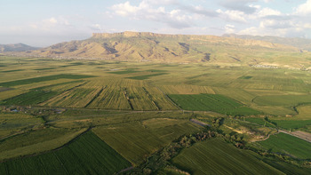
The river of Sarāb Qaleh Shāhin flows through the southeastern part of the Qaleh Shāhin plain, itself flanked by two limestone massifs (the mountains of Daneh Heshk on the south and Barz Mountain on the north). Other important sources of water in the region include the spring of Kah Sareh, likely to have been one of the principal water resources in the past. On the westernmost fringe of the Qaleh Shāhin plain is the Sarāb Garm, which flows to the Deyra River. The plain of Beshiveh-Pā-Tāq (Fig. 2), located in the northern part of this region, is watered by the Sarāb-e Mārāb river along with the smaller streams of Sarāb Galudar and Sarāb Jalālvand-e Soflā and the spring of Ali Gerda. However, because of the many rock outcrops and the resulting hilly landscape, this area is not ideal for agriculture, a fact which explains the lack of early settlement in this region, except for a limited number of sites dating to a general settlement peak during the Middle Chalcolithic. The Zahāb plain is the largest and most important intermontane plain in the western Zagros foothills and remains, even today, an important agricultural zone (Fig. 3). Through the Zahāb plain one reaches the Bakh and Gāvmishān mountains to the north, the Shāhneshin mountains to the east and the highlands and frontier mountains of Qarāviz to the west. The plain is watered by the Dala Shir, which flows from east to west, along with the Sarāb-e Seyed Sādeq, Sarāb-e Sarābleh, Sarāb-e Zahāb and Sarāb-e Kowāneg. Today, the Zahāb region is a flat plain partially covered by Quaternary sediments formed during the Holocene period. The landscape of the Neolithic and Chalcolithic periods, namely Early and Middle Holocene formations, is only poorly known to us, but recent discoveries reveal the significance of the Zahāb plain and the relatively high frequency of sites, when compared with other intermontane plains in the region, even if the rate of sedimentation appears to be higher here than elsewhere.

Fig. 2. The landscape of the Beshiveh-Pā Tāq inter-mountainous plain (aerial photo, view from northwest, courtesy of Reza Azizi)

Fig. 3. The landscape of the Zahāb plain (aerial photo, view from west, courtesy of Reza Azizi)
Archeological Research History and Recent Surveys
Despite its strategic importance, only a few significant sites have been identified in this region, and no extensive surveys or studies of settlement distribution have been undertaken recently. Surveys include that of Sarfaraz, Sarraf and Yaqmaei in Reference Sarfaraz, Sarraf and Yaqmaei1968, along with surveys and soundings conducted by Saeid Ganjavi in Reference Ganjavi1970. Sadly, however, the findings of both projects remain largely unpublished (Sarfaraz et al. Reference Sarfaraz, Sarraf and Yaqmaei1968; Ganjavi Reference Ganjavi1970). Kleiss also conducted a survey in 1969 in the plain of Qaleh Shāhin and its immediate surroundings, including the city of Sar Pol-e Zahāb. Published results are, however, limited to a report on historical and Islamic sites, and Kleiss makes no mention of any Neolithic or prehistoric site (Kleiss Reference Kleiss1975). Kermajani completed two survey seasons in 2007 and 2008, but no results have yet been published. The last field survey of the region prior to 2015, undertaken in 2009, was carried out by Heydari-Guran and Ghasidian (Heydari-Guran and Ghasidian Reference Heydari-Guran and Ghasidiyan2010) and sought to identify and document Paleolithic caves and rock shelters around Sar Pol-e Zahāb. Results of this work have not yet been published.
As such, current knowledge of the region available from the literature is limited to the locations of royal rock reliefs from the late third and early second millennia B.C., several monuments such as Taq-e Gara, Qaleh Yazdgerd, Zij-e Manizheh, Dokan-e Davoud, and the rock relief and rock inscription of Gotarzes, but there is next to no information on the settlement landscape of this important region during the pre- and proto-historic era. Consequently, a more comprehensive survey of archaeological remains in the region was deemed of immediate importance. To this end, an area of some 25,000 hectares on the western outskirts of Sar Pol-e Zahāb, including the plains of Zahāb, Qaleh Shāhin, Beshiveh, and Pā Taq, was chosen for an archaeological survey conducted by the first author (Alibaigi Reference Alibaigi2017) as part of a more extensive project called ‘The Garmsiri Project’. All told, the survey catalogue grew to encompass 193 sites. In the following, we limit ourselves to a discussion of the Neolithic sites (Fig. 4 and Table 1Footnote 1).
Table. 1. List of Neolithic sites in the Sar Pol-e Zahāb region


Fig. 4. Intermountain plains considered in this study and the location of identified Neolithic sites (courtesy of S. Bahramiyan and S. Heydari Guran)
Tapeh Gawra Kāh SarehFootnote 2
In the eastern section of the Qaleh Shāhin plain, west of the village of Tang Ismaeil Khan and south of the neighbouring village of Kāh Sareh, a large expanse of undulating terrain defines a site extending over c. 1200 × 400 m, with a maximum elevation of 5-10 m. The mound is called Tapeh Gawra (‘big hill’) by the locals. The remains of a small settlement, rising half a meter above the surrounding terrain and defined by gentle slopes on all sides, is located on the western end of this site. While located in a mountainous landscape, Tapeh Gawra is bordered by farmlands on its south and west (Fig. 5). The bed of the Sarāb-e Qaleh Shāhin, running from east to west, is located only 780 m southwest of the site. The spring of Kāh Sareh lies 200 m to the south. As the latter was flowing during the Neolithic, it can be considered the primary source of water for the Neolithic settlement. Judging from the topographic signature and the distribution of surface remains, the site extended over an estimated 120 × 50 m during the Neolithic. The area is currently under cultivation and much stone material from the site is used by farmers to mark field boundaries.
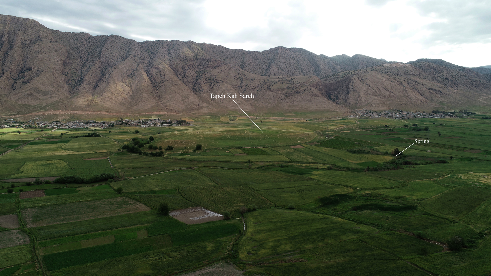
Fig. 5. The location of Kāh Sareh in the Qaleh Shāhin plain (aerial photo, view from west, courtesy of Reza Azizi)
A great number of sherds and some lithics were retrieved from the survey of Tapeh Kāh Sareh. Surface remains revealed the existence of Neolithic and Chalcolithic settlements, along with some temporary Islamic occupation. The 47 Neolithic sherds collected from the survey can be divided into two groups of plain and painted ceramics respectively (Fig. 6: 1–17, Fig. 7: 1–29 at top). The first group consists of eight plain sherds, made from a buff paste tempered with straw. The surface of some of the sherds is buffed and polished with a wet hand, while other sherds are not polished. The outer surface color of some of the sherds is uneven due to temperature fluctuations during firing, ranging from buff to buff-orange. All examples are handmade, of varying quality, and with a paste that has turned black and smoky. Bowls are the dominant form. Two containers with vertical handles and a horizontal hole in the handles represent a useful type (Fig. 6: 16, 17; Fig. 7: 8, 9). This type of handle has been reported among the Jarmo ceramics and dates to the Middle Neolithic period (Adams Reference Adams, Braidwood, Braidwood, Howe, Reed and Watson1983: figs. 107: 5–8; 109: 10–15; Braidwood and Howe Reference Braidwood and Howe1960: pl. 15: 5–8). Relatively large beakers with vertical rims and an angle near the base are also found (Fig. 7: 1).

Fig. 6. Neolithic sherds from Kāh Sareh and Nāwtapān

Fig. 7. Neolithic sherds from Kāh Sareh, Nāwtapān and Noshirwān (drawings by S. Zeinali)
The second group of ceramics consists of 39 painted sherds, which can be divided into two main categories; the first group consists of six sherds with a thick clay slip of red, black or deep reddish brown. Two of these sherds have this slip on their inner as well as outer surfaces, two have the slip only on the outer side, and the final two are only slipped on the inside. The second group includes painted ceramics with geometric patterns on the outer surface, and a single piece with parallel horizontal stripes on both inner and outer surfaces. These sherds are mostly buff in color with straw temper and handmade with a medium quality production technique. The paste is, in most cases, black due to irregular firing. Decorative patterns include horizontal stripes, crosshatching, parallel horizontal wavy stripes, chevrons, motifs known as tadpole patterns (e.g., Fig. 7: 24, 25), pendent triangles from the edge of the container, and some combined patterns, for example parallel horizontal and straight lines with pendent triangles between them or a mixture of net shaped diamonds and pendent triangles. These patterns are all made with a red to reddish brown paint. Judging from rim sherds, the dominant forms of these painted ceramics are bowls. Some of these sherds have a curved base, which is a prominent feature of ceramics of this period and has been reported from many sites, e.g., Sarāb, Guran and Jarmo (Levine and Young Reference Levine and Cuyler Young1986: fig. 1–3).
In addition, 37 lithic artifacts were retrieved from Kāh Sareh, including several flakes, blades, bladelets and debitage (Fig. 8: 013/1–4). These tools are made of high-quality cream and brown chert and high-quality veined obsidians. The number of chert flakes and debitage pieces from the site is considerably lower than the number of bladelets. Most obsidian finds are blades, and there are only two obsidian debitage pieces (Fig. 9). Flakes are usually atypical, and no cores were found. However, since these examples were retrieved through surface survey, we cannot offer a comprehensive interpretation based on selective sampling. In addition to ceramic sherds and lithic tools, a number of stone implements were also encountered, including several grinding stones, mortars, pestles and querns (Figs. 10–12). Such artifacts are common on Neolithic sites as components of food production (Conard and Zeidi Reference Conard, Zeidi, Borrell, Ibáñez and Molist2013; Darabi Reference Darabi2016; Mansouri and Mansouri 2015; Moradi et al. Reference Moradi, Mashkour, Eghbal, Azadeh Mohaseb, Ghassemi, Rahmati, Vahdati, Gratz, Tenberg, Roustaei and Mashkour2016: 10, fig. 10c) and can yield important insights on the workings of such settlements. However, because of the presence of remains from later periodsFootnote 3 at Kāh Sareh, these objects cannot be securely attributed to the Neolithic period.

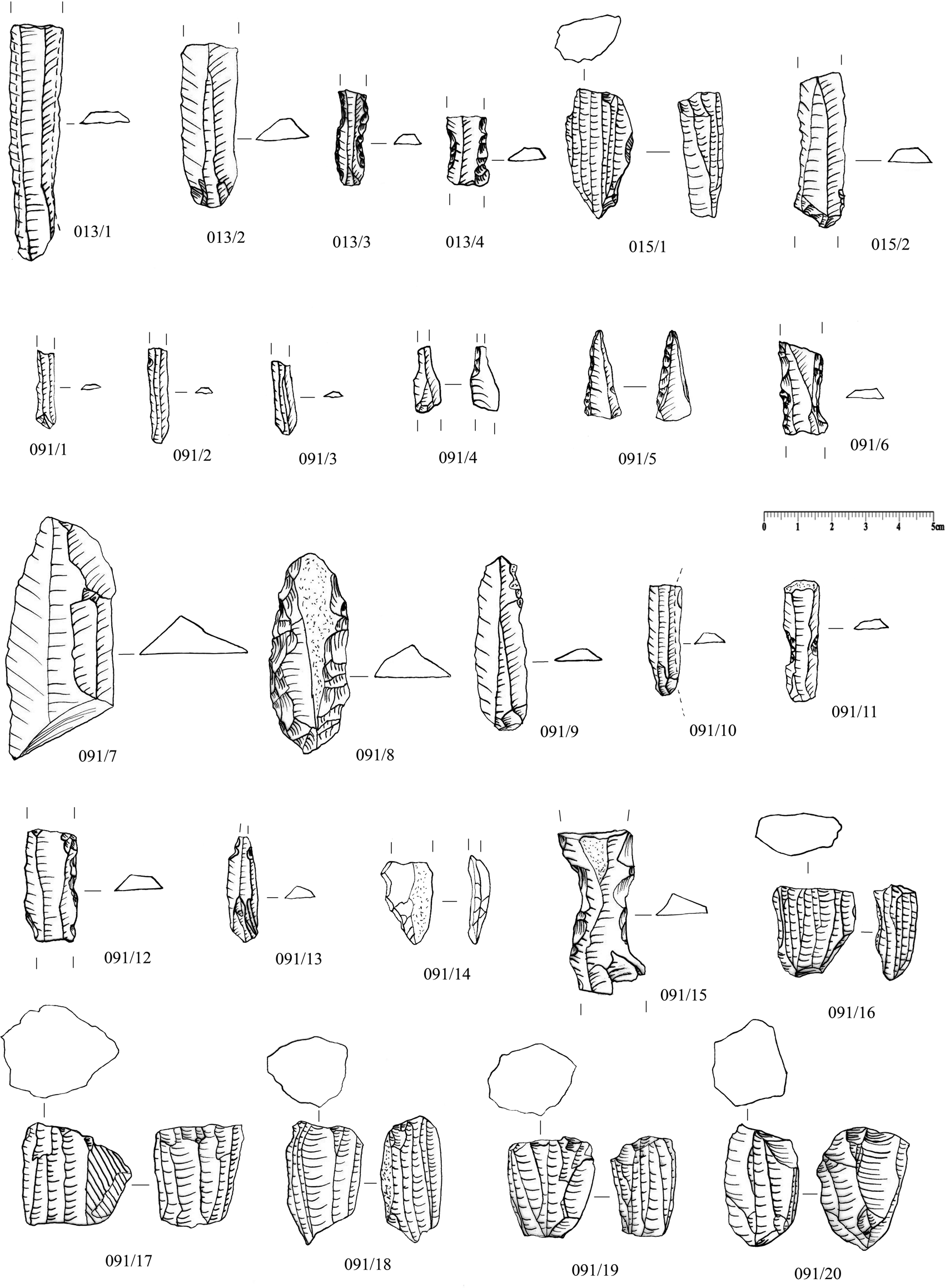
Fig. 8. Lithic tools from Tapeh Kāh Sareh (013), Asiab (015) and Tapeh Shotor Mel (091) (drawings by R. Naderi)

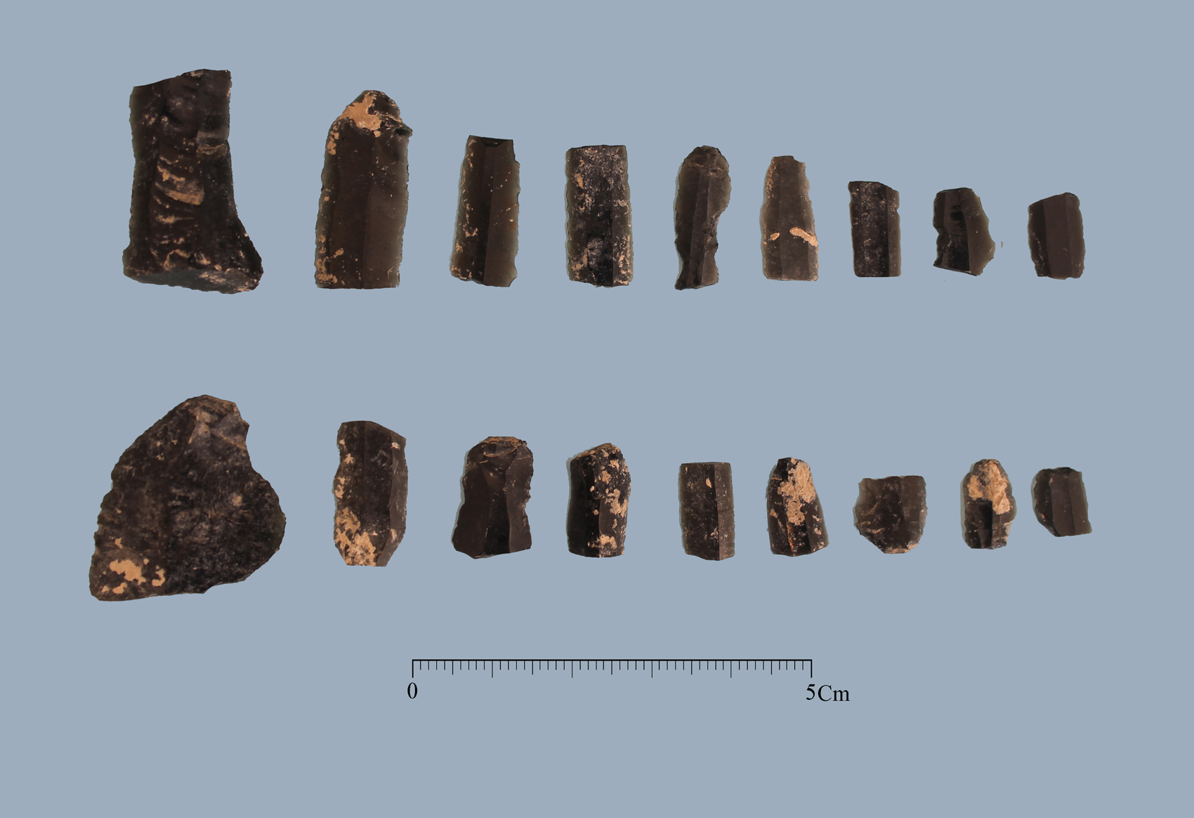
Fig. 9. Samples of obsidian artifacts from Tapeh Kāh Sareh (Photo by Farhad Fatahi)

Fig. 10. Ground stone tools from Tapeh Kāh Sareh (Photo by Farhad Fatahi)

Fig. 11. Ground stone tools from Tapeh Kāh Sareh (Photos by Farhad Fatahi)

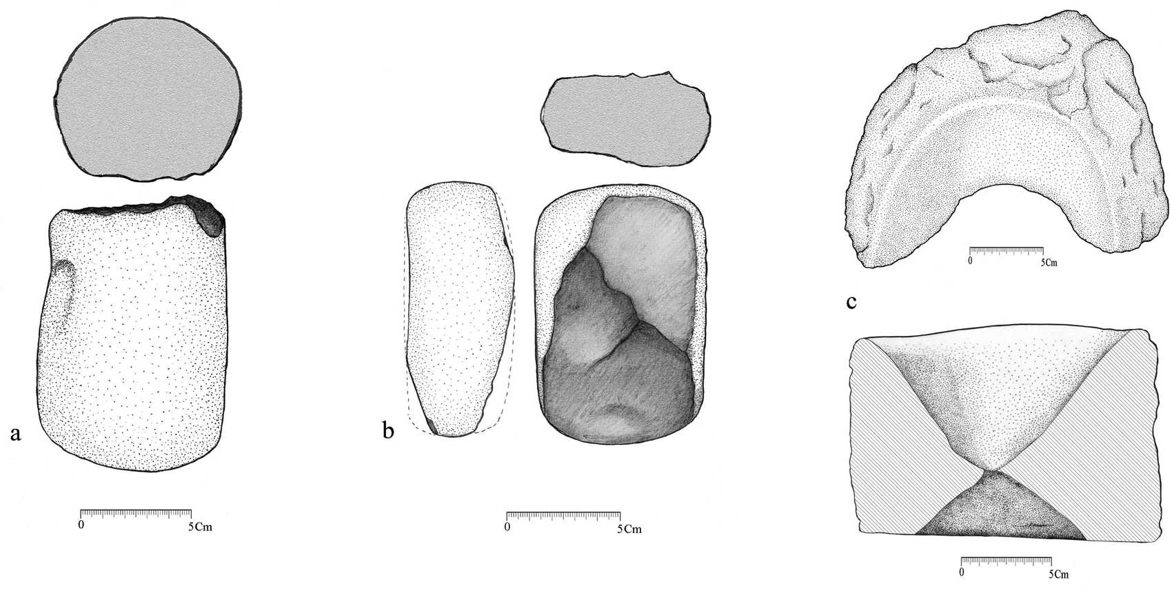
Fig. 12. Ground stone tools from Tapeh Kāh Sareh (drawings by N. Aminikhah)
ĀsiabFootnote 4
The site of Āsiab is located on the central eastern side of the intermontane plain of Qaleh Shāhin, 810 m southwest of Tapeh Kāh Sareh, between the ranges of Daneh Heshk and Barz. The site lies on an old terrace of the Sarāb-e Qaleh Shāhin overlooking the northern river bank. This is a common location for Neolithic sites; the southern part of the site has been inundated and partly destroyed by the river. In addition, sediments from winter and spring floods have heavily obscured the site, which we only discovered due to the regular plowing of the area.
Āsiab-e Tang-e Ismaeil Khān is located on an unassuming natural hill in the middle of the plain, extending over a very modest 20 × 20 m, with hardly any elevation profile. Like the surrounding fields, the site sees regular plowing. Surface finds from the surrounding area suggest further occupational remains of a recent Islamic date. A modern water mill was built nearby.
Our surface survey retrieved ten lithic pieces (Fig. 8: 015/1–2), including a bladelet core, another core, a blade, and seven flakes and debitage pieces. All pieces are made from a high-quality chert in a variety of colors from brown to light hepatic (deep brownish red), black, cream and gray with large white spots. We cannot yet say anything about the probable source of the raw material. The bladelet core dimensions are 2×3/3×3 centimeters, with a slightly patinated surface.
In addition to lithic finds, a piece of pottery was also found, namely a worn, coarse piece of ceramic with buff color paste and temper rich in straw (Fig. 13). These surface finds indicate that the site dates back to the Neolithic.

Fig. 13. Neolithic sherd (?) from Āsiab-e Tang-e Ismeail Khān
Tapeh NāwtapānFootnote 5
Tapeh Nāwtapān lies in the fields of the village of Qaleh Sefid in the northern foothills of Dane Heshk, bordering the plain of the Qaleh Shāhin. The site measures 65 × 45 m with a gently sloping rise reaching 2 m above the surrounding fields. Illicit excavations have left sizeable pits on the surface of the mound, and the site is thoroughly cut all around. These intrusions have seriously damaged the site but have also exposed cultural layers. Surface finds point to a multi-period occupation, dating as far back as the Neolithic, with further remains from the Chalcolithic, second millennium B.C. and Parthian periods.
Neolithic finds consist of 20 ceramic sherds, mostly found at the center of the site and around a robber pit. The sherds are mostly painted, although some are plain. The paste is buff and orange buff with straw and sand temper. All sherds are handmade with a thick mud coating in the same color as the paste. Except for three examples with a burnt core, the sherds are properly fired. Decorative patterns include geometric designs with checkered patterns and narrow bands and linear and geometric motifs typical of the Zagros region Neolithic (Fig. 6: 18–28).
The sherds are of relatively good quality and are in the category of medium fabric ceramics. The dominant forms are bowls, jars, storage pots and large jars (Fig. 7: 1-11, lower left). No Neolithic stone tools were retrieved from this site.
Tapeh Shotor MelFootnote 6
A range of narrow heights extends from southeast to northwest over a distance of 22.5 km between the plains of Qaleh Shāhin and Sar Pol-e Zahāb on the south and Pā Tāq on the north, reaching as far as the south edge of the Zahāb plain. Occasional breaks in this range form natural pathways facilitating interregional connections. These heights form the southern section of the anticlinal valley of Pā Tāq, a large fertile valley in the northern part of the county of Sar Pol-e Zahāb. The local residents refer to each section of this range with different names, i.e., from east to west Barz, Hezar Gereh, and Kal Ga Re. At the western end of the latter hill lies a vast archaeological site, entrenched between the Sarāb-e Qareh Bolagh (Qare Bolagh Spring) on the east and the stream that flows from this spring on the south, and village fields and the road between Sar Pol-e Zahāb and Salas-e Babajani on the west. The site is composed of multiple ridges and hills extending over an area of 540 × 535 m, which is partly occupied by the modern village of Qareh BolaghFootnote 7.
The main archaeological locale within this larger area is known as Shotor Mel, around which a number of smaller sites are found. Each has been registered separately, and surface finds indicate that they should be assigned to different periods of occupation. The main periods of settlement within this complex date to the Parthian and Sassanian eras, including the subsites of Qaleh Maryam/ Shekar Banou, Sarāb-e Qareh Bolagh 1 and 2, and Tapeh Shotor Mel itself, which extends from the foot of the hill to the southern edge of the village of Qareh Bolagh-e Sheikh Morad.
The site is located in a semi-mountainous landscape with easy access to the plain, the hills and several water resources, not to mention fertile and flat agricultural lands. There is no doubt that the large spring of Qareh Bolagh was one of the key factors in the formation and persistence of settlements in this area. The northern heights are called Shotor Mel by the local inhabitants. This part of the site measures 77 × 110 m, oriented northeast to southwest, and rises 14 m above the surrounding fields. Judging from surface finds, the Neolithic settlement was located on the western side of the site and encompassed an area of not more than 50×50 m. This estimate is based solely on the horizontal distribution of finds. While stone artifacts were numerous and widespread, no Neolithic ceramic artifacts were identified. This, however, should not automatically be taken to suggest that the site dates to the pre-pottery era, as the lack of ceramic surface finds may be due to the extensive vegetation cover encountered during survey. Stone tools were retrieved from the western side of the site, where the concentration was most dense. The sample includes 50 objects, including a bladelet core, blades and bladelets (Fig. 8: 091/1–20 and Fig. 14). This distribution is probably a result of the selective nature of our sampling. Apart from these, a number of punchers and side scrapers, toothed and ragged blades and bladelets were also found. Stone artifacts from Shotor Mel were made from pebbles of cream and light gray chert, with an imperfect rounded surface. Such stones are formed as small nodules in limestone outcrops, which abound in the foothills around the Zahāb plain and especially on the slopes of Bākh. As such, raw materials for stone tools found at Shotor Mel were locally available. Some obsidian debitage and small bladelets hint at the use of non-local raw material at the site during the Neolithic. While we are not currently able to provide a comprehensive analysis and discussion of the characteristics of these tools, nor a review of their presumed means of production, we can conclude that obsidian tools were used at Shotor Mel, similar to other sites such as Kāh Sareh and Noshirwān.
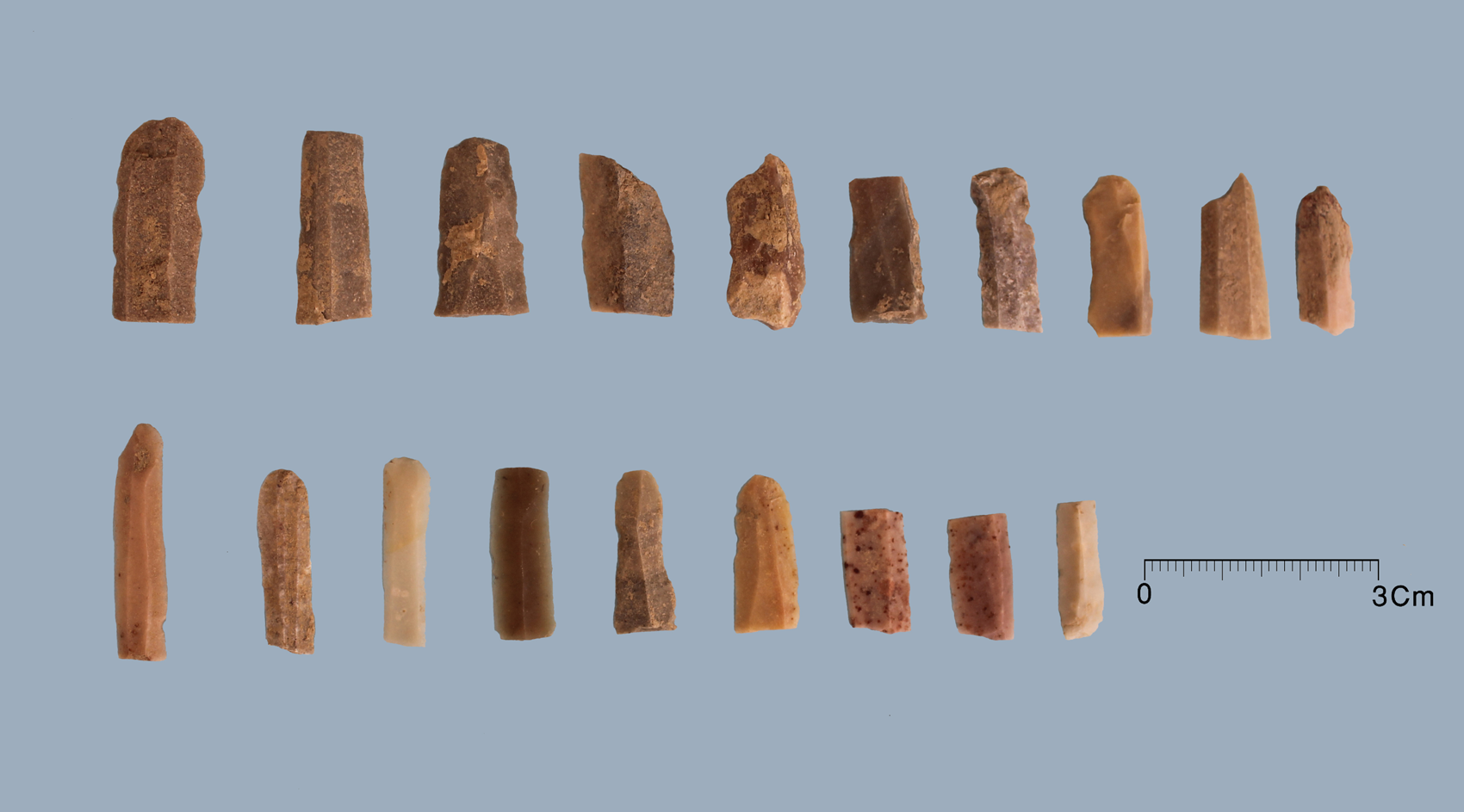
Fig. 14. Stone tools from Shotor Mel (Photo by Farhad Fatahi)
Tapeh NoshirwānFootnote 8
Tapeh Noshirwān is one of the largest settlements in the Zahāb plain, located on the western side of Zagros mountain range and Sar Pol-e Zahāb county (Fig. 15). The site is located in the central Zahāb plain south of the Dala Shir river, surrounded by farmland. The site, as delineated through onsite inspection (Alibaigi Reference Alibaigi2017), extends over 8.4 ha or 280 × 300 m, with a summit rising 16 m above the surrounding fields. Neolithic finds were confined to the eastern part of the site, with no contemporary material found in other sectors.

Fig. 15. Tapeh Noshirwān in the Zahāb plain, view from northwest (photo by A. Bāvarsāei)
Soundings as well as the general situation of the site and the wider region reveal that Noshirwān was probably formed on top of a natural hill. As such, the location of the site and the easy access to fertile farmland was the main reason for its expansion and development and the long occupational sequence observed here. The location of the site on top of a natural hill has preserved seventh millennium B.C. materials on the site from being buried under the alluvial sediments otherwise common in much of the Zahāb plain.
On the western side of the site, a significant number of stone tools including obsidian (160 pieces) and chert (40 pieces) was collected, indicating that part of the Neolithic deposits has not been obscured by occupational strata of later periods (Figs. 16–17). The obsidian sample includes bladelet cores, small single side scrapers and notches, numerous blades and bladelets, and a large amount of debitage. Although obsidian objects were found in almost all of the Neolithic sites identified in the Sar Pol-e Zahāb plain, their abundance at Noshirwān was considerable. The large quantity of debitage, artifacts and different types of cores reveal that obsidian tools were not imported as finished artifacts but were prepared and produced in this region. Judging from platforms and bulbs of percussion, objects were manufactured using the pressure method. Other stone artifacts were made of cream or gray chert, sometimes with pink veins. The cortex shows that the raw material of these objects was small rounded pebbles, similar to those seen now on the eastern edge of the Zahāb plain and in the northern foothills. These stones are generally of a modest size, which is the reason why objects derived from them are relatively small. Overall, stone artifacts from Noshirwān are derived from raw materials sourced locally, and obsidian objects were produced from raw material of a non-local origin. A considerable number of blades, bladelets, as well as a relatively large number of bladelet bullet cores were made of chert. Sickle blades, denticulated blades and bladelets, and single side scrapers were also found at the site. The typological and technological studies of these stone artifacts indicate that Noshirwān is a Neolithic site. A more precise dating is, however, not possible, but the lithic assemblage appears, on first impression, to relate most closely to ceramic materials from the Middle Neolithic also found at the site.
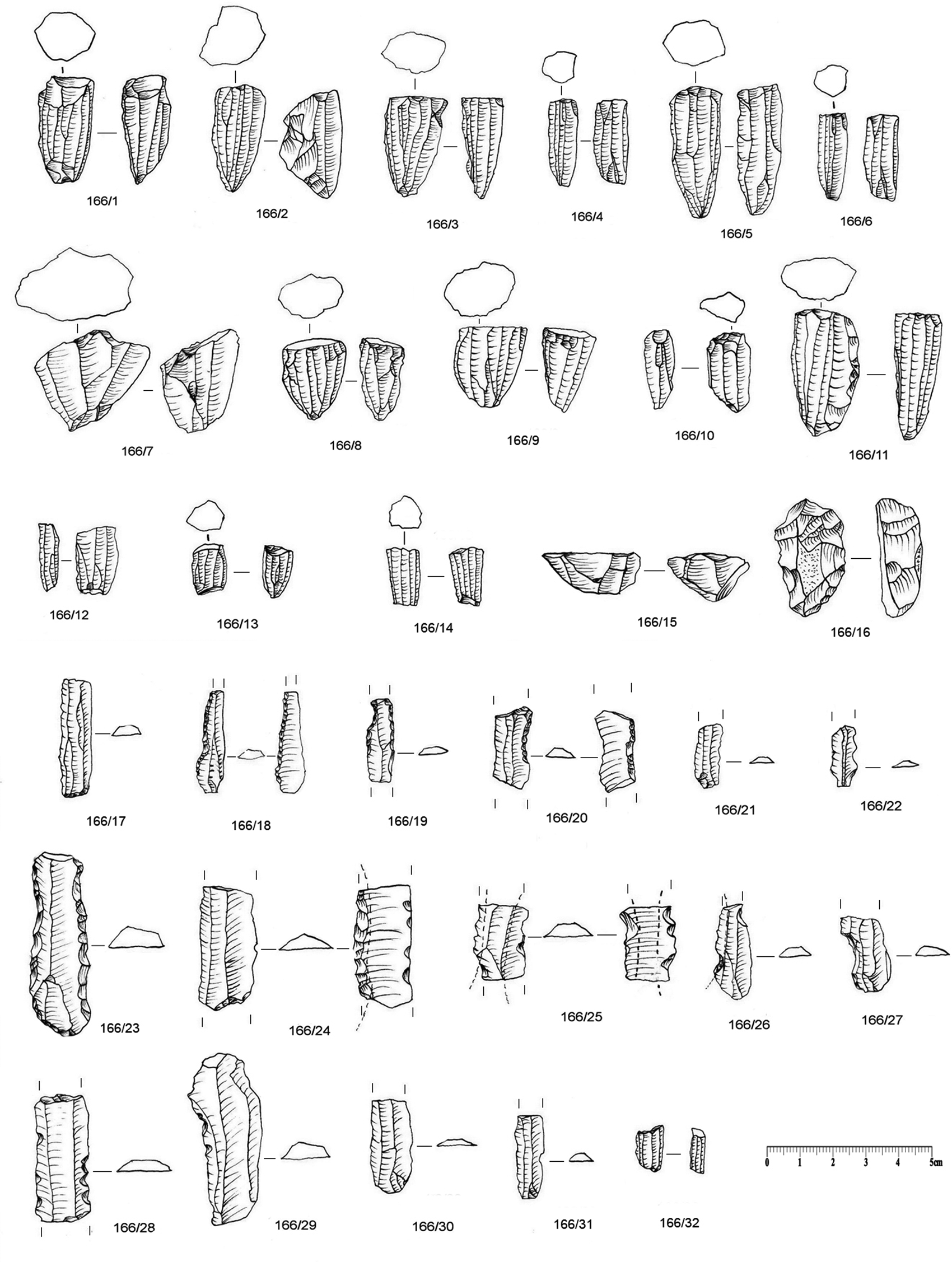
Fig. 16. Stone artifacts from Tapeh Noshirwān (drawings by R. Naderi)
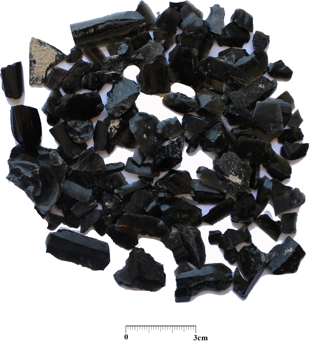
Fig. 17. Obsidian artifacts from Tapeh Noshirwān
A considerable collection of sherds was retrieved during our survey of Noshirwān. This collection belongs to the Neolithic and late Chalcolithic periods, the second millennium B.C. and later historical periods. Only two sherds from Neolithic period were found, both in the eastern part of the site (Fig. 7: lower right). One has buff paste with organic temper and buff slip. Although it is just a small sherd from a handmade vessel, the distinctive purple tadpole motif on a buff background makes an attribution to the Neolithic period virtually certain. Similar examples are found at Gurān (Levine and Young Reference Levine and Cuyler Young1986: fig. 1.3; Meldgard et al. Reference Meldgard, Mortensen and Thrane1963: fig. 17b, c, e; Mortensen Reference Mortensen2014: fig. 64 c-i; fig. 65a-d, f), Sarāb (Darabi Reference Darabi2015: 46, fig. 5.21) and Jarmo (Adams Reference Adams, Braidwood, Braidwood, Howe, Reed and Watson1983: fig. 105: 13; Braidwood and Howe Reference Braidwood and Howe1960: pl. 15: 12, 17). The other sherd stems from a handmade vessel with mineral temper, buff or orange color paste and a buff slip coating. The ware is relatively coarse and well baked. The outer surface is decorated with ochre-colored filled circular motifs. Similar examples are known from Tapeh Sarāb in Kermanshāh (Darabi Reference Darabi2015: 46, fig. 5.21) and the Neolithic settlement at Umm Dabaghiyah in Mesopotamia (Kirkbride Reference Kirkbride1972: pl. X: 3, 10). While the sample is modest in size, features of the ceramics and stone artifacts retrieved from Noshirwān confirm the dating proposed above.
Parts of two stone vessels have been also obtained from the site. One of them is made of high quality, light brown marble with a 7 mm thickness. The other piece is white and pink in color and of lower quality. This piece probably belonged to the rim or the body of a vessel with a 22 mm thickness (Fig. 18). Similar examples are known from surveys in East Chia Sabz (Darabi Reference Darabi2015: 63, fig. 5.46), Gurān (Mortensen Reference Mortensen2014: fig. 76 a), Ali Kosh (Hole et al. Reference Hole, Flannery and Neely1969: 108, fig. 42: L and P) and Jarmo (Adams, Reference Adams, Braidwood, Braidwood, Howe, Reed and Watson1983: Fig. 104: 2-3; Braidwood and Howe Reference Braidwood and Howe1960: fig. pl. 15: 13).
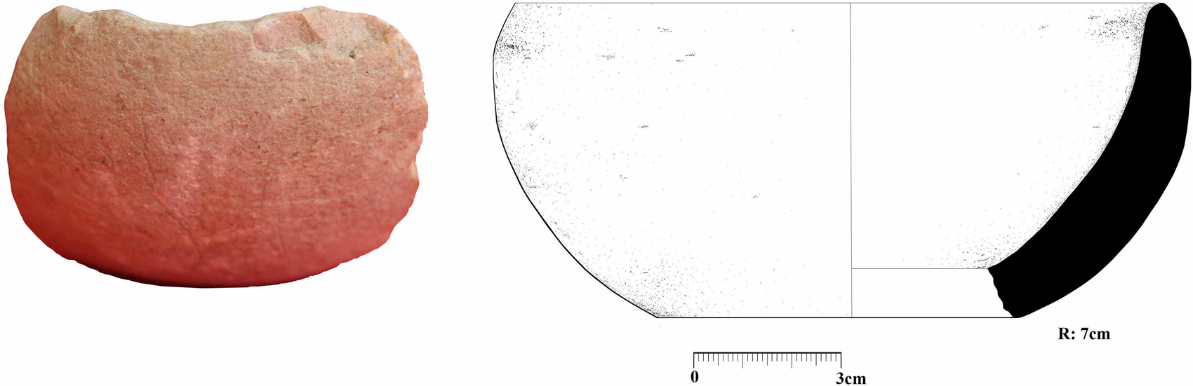
Fig. 18. Neolithic stone vessel from Tapeh Noshirwān (Photo and drawing by Ramin Chehri)
The region of Sar Pol-e Zahāb during the Neolithic Period
Amongst the 193 identified sites in the region of Sar Pol-e Zahāb, Neolithic finds were retrieved from five sites. These sites are Kāh Sareh, Āsiab, Nāwtapān and Shotor Mel in the plain of Qaleh Shāhin and Tapeh Noshirwān in the Zahāb plain. These sites are located between 617 and 759m above sea level. The presence of a bladelet core and an unretouched flake, as well as some debitage pieces at the site of Beyreg close to the village of Balvan, can also be considered evidence of a Neolithic settlement (Fig. 19). Due to the clear abundance of bladelet cores, produced through the use of the pressure technique during the Neolithic, and their clear absence during the Chalcolithic, finds from Beyreg cannot reasonably be attributed to the latter period. However, the sum total of the evidence is still too sparse to allow for a conclusive dating of this material.
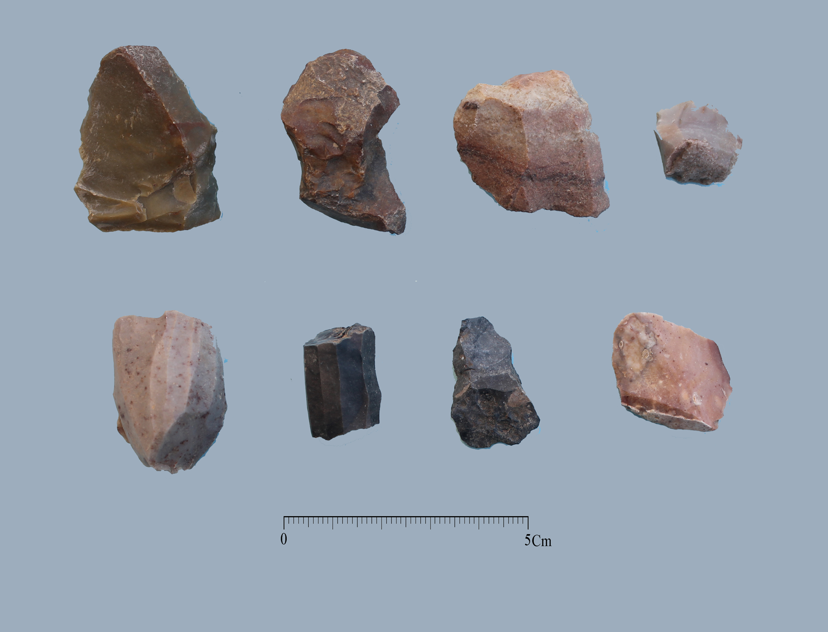
Fig. 19. Neolithic finds from Beyreg (Photo by Farhad Fatahi)
Neolithic sites identified here generally display a low topographical signature and a very modest surface extent. Although the exact surface extent of the sites discussed here cannot be accurately defined, and Neolithic remains at most sites are buried under succeeding occupational strata, the estimated extent of sites such as Kāh Sareh, Āsiab, Nāwtapān and Shotor Mel cannot be anything but very limited. None of these are extensive or indicative of substantial deposits, unlike the Neolithic site of Sar Pol-e Zahāb and the better-known examples higher up in the Zagros, e.g., Ganj Dareh, Gurān and Sheikhi Abad, which have yielded considerable Neolithic material and also contain extensive and deep deposits. While no PPN sites have been identified in the region as part of our survey, the potential presence of such sites is not unlikely, for example at Kāh Sare, Shotor Mel or Noshirwān. Stratigraphic excavation of such sites may be able to prove this hypothesis. At present, however, the available evidence indicates that the plains of Sar Pol-e Zahāb were occupied during the Pottery Neolithic (Middle Neolithic or seventh millennium B.C.). Prominent ceramic traditions include the Sarāb Linear, Sarāb Geometric and Tadpole Ware styles, with no trace of later types such as Siahbid (Late Neolithic) within the survey area.
Conclusions
The general lack of Paleolithic open-air sites and their concentration in caves and rock-shelters probably relate to regional geomorphological trends. Neolithic sites, in contrast, are situated on low heights in the plains or in the foothills. Many more Neolithic sites have certainly been covered beneath later layers of sedimentation. Our survey has only identified those that, for a variety of reasons, have avoided such geomorphological processes. Cultural materials obtained from these sites display many similarities with Neolithic finds from, e.g., Gurān and Sarāb higher up in the Zagros, or Jarmo and Tamerkhan in Iraq.
Our findings indicate the important role of environmental and geographical factors in the formation of the archaeological landscape of the Neolithic in this region. The mountains, e.g., the Bākh, Shāh Neshin, Gāwmishān, Bān Tāq, Dane Heshk, Barz etc., and major rivers such as the Alvand and Dala Shir, flowing from northeast to southwest, as well as the many springs and ponds in the area, have worked to create conditions ideal for early settled communities. But these features also introduce a number of particular obstacles for the proper identification of archaeological sites. The geographical characteristics of the Sar Pol-e Zahāb region have clearly been key factors in the formation, preservation, and the occasional disappearance of Neolithic sites. Extensive surveys in the central Zagros have identified only very few Early and Middle Neolithic sites, and future surveys are unlikely to significantly alter this picture. Levine and his colleagues believe that geomorphological conditions are even more extreme further east, e.g., in the Māhidasht, due to intensive and lasting sedimentation that is likely to have buried most early settlements (Brooks Reference Brooks1989; Brooks et al. Reference Brooks, Levine and Denell1982). On the other hand, Smith and Mortensen have stated that even though geomorphological factors may have destroyed or buried many early settlements, they should not be regarded as the sole reason for the relative dearth of Neolithic remains in the region (Smith and Mortensen Reference Smith and Mortensen1980). Smith and Young have pointed to the more likely presence of archaeological remains of early settlements in closed areas and narrow upland side valleys, while their presence in wide valleys is likely to be exceedingly rare (Smith and Young Reference Smith, Young, Young, Smith and Mortensen1983).
It seems evident that the environmental characteristics of the survey area, as well as the general location and distribution of identified sites, would point to the existence of many more sites from the Neolithic in the region of Sar Pol-e Zahāb. A closer look at settlement distribution patterns and the location of individual sites indicates that these sites were particularly well suited to survive Holocene sedimentation. The particular location of some of these sites, especially Tapeh Kāh Sareh and Noshirwān on top of isolated hillocks, highlights the specific processes of site formation and post-depositional transformations of Neolithic settlements. Neolithic remains found at these two sites were not obscured by sedimentary deposits, while sites such as Āsiab, located lower in the plain, yielded much less easily accessible Neolithic phases, the site being almost completely buried by sedimentationFootnote 9. Neolithic remains found at this site and at Nāwtapān were only identified because of recent agricultural activities and deep ploughing. These examples clearly indicate a positive relationship between site visibility, human disturbance, and later changes as far as Neolithic settlements are concerned. The location of sites such as Kāh Sareh, Noshirwān, Nāwtapān and Shotor Mel shows that Neolithic sites tend to be located in foothills, on the edge of alluvial plains, and on natural heights. The presence of plain sherds with vegetal temper, made with simple production techniques, in an old canal or river bed below alluvial deposits in the northeastern part of the Zahāb plain provides, further evidence of landscape change through sedimentation following the end of the Neolithic. Mechanically excavated trenches in the southern part of Sar Pol-e Zahāb county clearly show the considerable depth of sedimentation layers, occasionally up to five metres thick (Figs. 20–22).

Fig. 20. Eroded sediments from Barz mountain accumulated in the Qaleh Shāhin plain (Photo by Farhad Fatahi)

Fig. 21. Modern trench showing the depth of alluvial sediments of the Holocene period on the Qaleh Shahin plain, near the current city of Sar Pol-e Zahāb

Fig. 22. Layer of Neolithic period materials (indicated by arrow) under alluvial deposits of the Holocene period on the northeast of Zahāb plain, near Elyāsi Khalife Hassan village.
A similar case can be made for the Sarfirouzabad plain southeast of the Māhidasht region (Niknami and Nikzad Reference Niknami and Nikzad2012; Niknami et al. Reference Niknami, Nikzad, Alibaigi, Matthews and Fazeli Nashli2013, Reference Niknami, Alibaigi, Nikzad, Heydari Dastenaei, Zeinivand, Rezaei and Manhobi2015), where identified Neolithic sites are all found on the edge of the alluvial plain. When considering the central Zagros region more generally, and here specifically areas with less substantial levels of Holocene sedimentation, similar processes are in evidence.
Landscape transformations during the Holocene caused by both climatic conditions and geological processes have drastically changed the face of alluvial plains such as the Māhidasht, Kermanshāh, Chamchāl, Islam Abad-e Gharb and Rawansar. The result of such processes is that most older sites, usually not very extensive, were buried under considerable layers of sedimentation. Neolithic sites identified across this vast region are those rare cases that avoided alluvial sedimentation. The location of sites such as Bar-e Palang at Qasr-e Shirin, Tapeh Kana-Har in the Beivanizh plain, Sarāb-e Mailehsar in the Shohān plain, Vargar in Doroud Farāmān, Tapeh Sarāb Yāvari in the Kermanshāh plain and several others in the Chamchāl plain, and the pronounced absence of Neolithic settlement remains elsewhere in upland alluvial basins, testify to the broad application of these processes in the Central Zagros (see Fatahi Reference Fatahi, Azizi Kharanaghi, Khanipour and Naseri2015; Moradi Bisetoni Reference Moradi Bisetoni2010; Mohammadi Qasriyan Reference Qasriyan2013; Darabi Reference Darabi2015; Alibaigi Reference Alibaigi, Matthews and Fazeli Nashli2013; Mansouri and Mansouri Reference Mansouri and Mansouri2016).
The significant extent of sedimentary deposit in the Sar Pol-e Zahāb region has allowed for the identification of only a few scattered sites, including the intermontane plain of Qaleh Shāhin with four sites (Kāh Sareh, Āsiab, Nāwtapān and Shotor Mel), the Zahāb plain with one site and, finally, the Beshiveh–Pā Tāq plain where no sites were located. This does not necessarily mean that the rest of the valleys around Sar Pol-e Zahāb were not occupied during the Neolithic, but the presence of significant and lasting Neolithic settlements in these areas seems unlikely. It should be noted that this region may have served an important role as a source of raw materials for stone tools, pasturing, collecting wild fruits, cereals and wood, along with other activities that are difficult or impossible to identify archaeologically (Levine and McDonald Reference Levine and McDonald1977). Findings from the region of Sar Pol-e Zahāb presented here, and the role of this area as a link between the wider Zagros mountain ranges in the east and Mesopotamia in the west, have helped us to gain a better understanding of early connections between these two regions. Analysis of these findings, especially ceramic material, has revealed that these regions had an integrated ceramic tradition during the Neolithic, which is probably related to their cultural integrity. Similarities between cultural materials from the Kermanshāh, Hulaliān and Māhidashat plains and assemblages from Iraqi sites should not be linked merely by analogy, but by a shared tradition visible on the ground from Neolithic settlement remains. Henrickson and Vitali have previously advanced a similar view on the similarities in distribution of cultural material in assemblages from the fifth millennium B.C. Zagros and northwestern Iran (Henrickson and Vitali Reference Henrickson and Vitali1987). While similar views have also been espoused for cultural relations of eighth and seventh millennium B.C. Neolithic communities, when a lithic industry known as M'lefaatian was common, local differences between lithic artefact characteristics should be observed (Kozlowski Reference Kozlowski, Gebel and Kozlowski1994, Reference Kozlowski1999; Kozlowski and Aurenche Reference Kozlowski and Aurenche2005). Given the nature of the lithic industry technology, such arguments cannot be easily verified. When turning to similar signs of integration of pottery traditions, the cultural integrity, or at least the integrity of the tradition of pottery production, can be more fruitfully discussed. Similarities in ceramic design and repertoire may therefore be regarded as important clues to the interaction of distant communities during this period. This level of interaction is also evident in the distribution of other types of material, e.g., obsidian and marble objects.
Sar Pol-e Zahāb has formed a crucial link between Mesopotamia and the western highlands of Iran for thousands of years. This role as a cultural crossroads dates back at least to the fourth millennium B.C. and very likely earlier, to the seventh millennium B.C. or even older periods, e.g. the Paleolithic. This cross-regional link is clearly emphasized by the lack of similar material horizons (Sarāb and Jarmo ceramics) in adjoining provinces such as Kurdistan and Azarbāijan,Footnote 10 in counties such as Pāveh and Salās-e Bābājāni north of the main route through Sar Pol-e Zahāb, and in the western reaches of the province of Ilam south of the Sar Pol-e Zahāb main route. In contrast, such materials abound around Sar Pol-e Zahāb and further into the Zagros, e.g., at Islam Abad-e Gharb (Abdi Reference Abdi1999, Reference Abdi2002) and in the Māhidasht and Kermanshāh plains (Alibaigi Reference Alibaigi, Matthews and Fazeli Nashli2013; Braidwood Reference Braidwood1960a; Levine and McDonald Reference Levine and McDonald1977; McDonald Reference McDonald1979). Therefore, we propose that the cultural and economic relations between the Mesopotamian plain, the Lake Van basin, and the central Zagros were not conducted directly from northwestern Iran, but through the western foothills of the Zagros, and more specifically through from valleys around Sar Pol-e Zahāb.
Based on our survey, Noshirwān was the site with the densest concentration of Neolithic materials. The relative abundance of stone artifacts and the limited number of sherds found at this site may indicate an earlier, Pre-Pottery Neolithic presence in the region. The most important Neolithic settlement identified was, however, Tapeh Kāh Sareh. The diverse collection of Neolithic pottery from obtained from this site will be a valuable assemblage from which to study the ceramic horizon of the broader region.
Acknowledgments
We would like to express our sincere gratitude to Dr. Siamak Sarlak, manager of the “Garmsiri Project” in western Iran, as well as Dr. Alireza Sardari Zarchi of the Iranian Center for Archeological Research. We would also like to thank the members of the survey team, Dr. Shokouh Khosravi, Dr. Mohsen Heydari Dastenaei, Farhad Fatahi, Mohamad Javad Jafari Sumar, Touraj Sadeqi, Hamdollah Sheikh Hosaini and Naser Aminikhah. We also thank Ms. Somayeh Zeinali for drawing the sherds, Mr. Rahmat Naderi for drawing the stone tools, and Mr. Naser Aminikhah for drawing the ground stones. We are grateful for the useful information and advice given to us by Mr. Farhad Moradi, Dr. Iraj Rezai and Dr. Saman Heydari Gurān, as well as the maps of the region provided by Dr. Saman Heydari-Gurān and Mr. Saeid Bahramian. We would like to thank Dr. Hojjat Darabi for reviewing this paper and his valuable comments and advice. Finally, we would like to thank Dr. Rune Rattenborg for editing our English.