


I. INTRODUCTION
Automatic-dependent surveillance–broadcast (ADS–B) [1–3] is a key enabler for all future air traffic management (ATM) proposals. ADS–B, with the additional deployment of other surveillance sensors such as wide area multilateration (WAM) systems and mode S radar, will progressively phase out current secondary surveillance radars. ADS–B may be complemented by traffic information system–broadcast (TIS–B) [4], to enable airborne surveillance of non-ADS–B equipped aircraft.
The research described in this paper has been performed within ATLANTIDA, a large Spanish project aimed at implementing a completely automatic prototype of a future trajectory-based operation (TBO) ATM system with unmanned aircraft systems (UASs), including both airborne equipment (navigation, automated flight management, flight control, airborne surveillance, etc.) and ground functions (navigation support, ATM, ground surveillance (SURGND), communication management, remote flight management, user operation center, traffic flow management, etc.). A significant novelty in ATLANTIDA is the integration of such a system within an air-inclusive system wide information management (SWIM) middleware connecting all ATM systems. This SWIM concept, also present in SESAR [5] and NEXTGEN [6], assumes that all data interchange and information retrieval demands are performed using a unique communication and middleware infrastructure. So, in ATLANTIDA, ADS–B was implemented over a SWIM network comprising both ground and airborne equipments. ATLANTIDA SWIM was composed of two modes of operation: request–reply, implemented using common object request broker architecture (CORBA) procedures, and publish–subscribe, using data distribution service (DDS). This allows a flexible implementation of the communication protocols and functionalities based on commercially available middleware, with the following potential advantages over current ADS–B implementations:
• Use of shared communication equipment for all air-to-ground communications, with support for quality of service (QoS) management (latencies and priorities) using a high bandwidth communication channel. ATLANTIDA system relies on Microhard® UHF modems, using frequency hoping spread spectrum (FHSS) modulation in the 902–928 MHz band, with a resulting 1.2 Mbps data rate, and time division multiplex access (TDMA) protocols, controlled by the ground station modem. It allowed free experimentation on communication protocols, although an operational implementation would surely need the reuse of current International Civil Aviation Organization (ICAO) standardized communications bands.
• Capability to use compressed and encrypted communication means, enabling safer provision of aircraft kinematic state to ground and to nearby aircraft, and optimal exploitation of communication bandwidth.
• Definition of an easily upgradeable communication means, where interchanged data may be modified by a redefinition of the messages using a simple template mechanism (*.idl files), and automatic regeneration of executable programs, while protocols may be changed by simple QoS changes or software modifications.
The designed ADS–B/TIS–B-based surveillance is based on this SWIM concept, being a software-based solution using standard hardware and middleware, while current approaches are based on the use of certified data-buses and hardware, or specific protocols on ground such as all purpose structured Eurocontrol surveillance information exchange (ASTERIX). The design covers both the air and SURGND segments.
Regarding SURGND, it is a complete system with all the typical surveillance functions (measurement association, track initiation and deletion, measurement filtering, integrity tests to increase reliability, etc.) and additional procedures for computational load management. It has been implemented using a modified AIRCON® data processing station, based on Linux middleware with specific wrappers to enable their integration in ATLANTIDA–SWIM. The system is partially implemented in C ++ (for the communication and ATLANTIDA ADS–B data processing procedures) and ADA (for the rest of AIRCON facilities, including multisensor data processing, display management, and user interface). In ATLANTIDA, all experiments were conducted only with ADS–B data, although AIRCON is capable of also processing radar and WAM data. In fact, the expertise gained in ATLANTIDA has been used to enhance the operational AIRCON surveillance data processing, extending it to process current WAM and ADS–B messages.
ADS–B/TIS–B-based air surveillance (SURAIR), with functionality similar to SURGND, has also been implemented. It has stringent computational requirements due to the fact that it is implemented on a mobile platform: it is part of the software included in the airborne embedded PC with real-time Linux in charge of flight management and flight control. It is a completely new implementation of ADS–B/TIS–B-based surveillance through a multithreaded application developed using C + +, whose communication middleware is based on RTI® DDS implementation [7], and ATLANTIDA SWIM libraries.
ATLANTIDA ADS–B/TIS–B can be seen as an extension of current ADS–B and TIS–B protocols. New data formats have been defined, taking into account the new necessities of TBO and automated ATM. One of the key elements of this kind of operations is the need for very accurate medium-term trajectory predictions. Our ADS–B design enables the provision of on-board meteorological measurements to a ground facility, to enable high-quality tuning of meteorological models. Another important element of TBO is the capability to interchange trajectory information among different ATM actors. In ATLANTIDA, it is performed using the concept of aircraft intent [Reference Lopez-Leones, Vilaplana, Gallo, Navarro and Querejeta8]. The broadcasting of aircraft intent information is done through ADS–B to support extensions of ATLANTIDA concept to Airborne Separation Assurance Systems (ASAS), where each aircraft could change their trajectory on the basis of surrounding aircraft intended trajectories.
An important requirement of the whole surveillance infrastructure described in this paper is its capability to be used both for simulation and for experimentation in real flights.
The rest of the paper is organized as follows. Section II contains an introduction to current ADS–B and TIS–B technologies, focused in the information they can interchange and on the protocols used for this communication. Section III describes the relation of air and SURGND systems with other avionic and ATM systems. Section IV describes the new data formats and protocols to be used in ATLANTIDA, while Sections V and VI describe the internal air-to-air and SURGND systems structure and algorithms. Then, the paper describes the experimental and simulation deployment used for the evaluation of the system and Section VIII describes the simulation and real data results. Finally, Section IX includes some conclusions on ATLANTIDA ADS–B implementation and some future research lines.
II. CURRENT ADS–B AND TIS–B IMPLEMENTATIONS
Mode S squitter (also known as 1090 ES) is currently the most used ADS–B implementation. In fact, both SESAR [5] and NEXTGEN [6] take an approach of concentrating efforts on this technology, which can be installed and updated with minor changes into currently mandatory Mode S transponders (for a great part of the aircraft fleet). The different messages available and their fields are described in ICAO Annex 10 [1]. All squitters contain unique ICAO address (Mode S) code unequivocally identifying the transponder/aircraft. The kind of information provided is basically kinetic (position and velocity). There are mainly two kinds of protocols in Mode S squitter: based on quasi-periodic broadcast of messages, for most types of messages; and based on event driven broadcast of messages. They use a shared communication channel that may lead to a high amount of message collisions, effectively reducing nominal measurement period from 1 s.
VDL Mode 4 [3] is a VHF data link technology, also standardized by ICAO, and designed to support communication/navigation/surveillance (CNS)/ATM digital communications services. In the surveillance domain, it was investigated as a candidate ADS–B data link (in complement to 1090 ES) to support ADS–B applications. It provides means for the periodic transmission of quite a lot of kinematic and intent related information potentially using broadcast, multicast, or addressed communication procedures. It can also define event driven procedures for the transmission of data. It is based on a TDMA process potentially managed by the own airborne radio stations (self-adaptive TDMA).
The universal access transceiver (UAT) system [2] is specifically designed for ADS–B operation. UAT has lower cost and greater uplink capacity than 1090 ES. UAT does not only provide ADS information: users have access to ground-based aeronautical data and can receive reports from surrounding traffic (using FIS–B and TIS–B protocols). In the United States, the UAT link is intended for general aviation aircraft. From a controller or pilot standpoint, the two links operate similarly. Each aircraft broadcasts UAT ADS–B messages once per second to convey kinetic state and other information.
Finally, TIS–B is the broadcast of traffic information to ADS–B-equipped aircraft from ADS–B ground-based stations. The sources of this information are air traffic surveillance radars or other surveillance sensor such as WAM. TIS–B is intended to provide ADS–B-equipped aircraft with a complete traffic picture in situations where not all nearby aircraft are equipped with ADS–B. There are implementations and research on TIS–B based on the three previous technologies (Mode S squitter, VDL [4], and UAT).
Although not properly ADS–B/TIS–B, there are other surveillance technologies directly related to ADS–B. These are the surveillance technologies related to ADS–C (ADS – Contract [9], as FANS-1), Mode S data link applications [1] and Airborne Collision Avoidance System (ACAS; [1]). These surveillance technologies are based on the data contained within the Mode S transponder or navigation system. The definition of ATLANTIDA surveillance messages and modes of operation also took into account the information provided by these systems.
III. ATLANTIDA SURVEILLANCE DESCRIPTION
ATLANTIDA surveillance infrastructure is based on the definition of two interrelated systems, one deployed on airborne platforms (SURAIR), and another one compiling data from all aircraft on ground (SURGND). Figure 1 shows the main relations between SURAIR and SURGND systems and surrounding ATLANTIDA systems.

Fig. 1. Overall ATLANTIDA surveillance architecture.
There are two main roles of SURAIR: ADS–B message compilation and broadcasting, which enables the rest of the surveillance functions; and creation of a local air picture situation, to be potentially used by air automation systems. In this second role, its main data sources are nearby aircraft SURAIR for ADS–B and SURGND for TIS–B, and its main information consumer is the flight manager (FM), which could provide this information, integrated with trajectory information, to other subsystems.
The main role of SURGND in ATLANTIDA is to create an air picture situation to be used by the ground ATM system. Its main data source is SURAIR (although the system might exploit other sensors information), and its main data consumer is the traffic manager (TM), which provides this information, integrated with trajectory information, to other subsystems, and also performs negotiation of trajectories with aircraft, automated conflict detection and resolution procedures, etc. SURGND also provides traffic information (tracks) to a remote FM (RFM), which can act as a means for the remote control of the vehicle. It also provides meteorological samples to the meteorological system (called DMET) to enable accurate meteorological modeling. Finally, it provides SURAIR with TIS–B data of aircraft, and it can manage TIS–B data rate.
In order to perform time-synchronized hybrid simulations for experimentation, all those systems are connected to a simulation/experimentation control engine. Additionally, they have means for data recording, enabling later simulation/experimental analysis.
IV. ATLANTIDA ADS–B AND TIS–B MESSAGES AND PROTOCOLS
ATLANTIDA ADS–B and TIS–B data formats are an extension of the available ADS–B and TIS–B formats that include new parameters of interest for short-term and medium-term trajectory prediction. The parameters are:
• Aircraft mass.
• Intent information, in a much more detailed format than previous systems [Reference Lopez-Leones, Vilaplana, Gallo, Navarro and Querejeta8].
• Attitude information.
• Aerodynamic configuration (flaps, landing gear, and speed brakes state).
Table 1 describes ATLANTIDA ADS–B and TIS–B data formats. Common fields appear in all messages.
Table 1. Message formats.

Another key difference with other ADS–B implementations is the use of much higher resolution fields for the representation of measurements, so that quantification errors are negligible.
ADS–B/TIS–B protocols are implemented with SWIM middleware making use of publish–subscribe paradigms based on DDS. All messages are provided to their consumers periodically, with means to control the data rate, and therefore the overall communications load. Those parameters are especially important for constrained air–ground communications and for airborne inter-process communication. ADS–B and TIS–B periodicities are controlled by SURAIR and SURGND systems on the basis of the surrounding consumer needs and surveillance quality assurance.
V. SURAIR STRUCTURE AND ALGORITHMS
The structure of SURAIR system is depicted in Fig. 2.

Fig. 2. SURAIR internal structure.
It is mainly divided into two parts, to be described next.
A) ADS–B compilation and broadcast
SURAIR receives ADS–B data from FM (callsign, intent, and status) and NAVAIR (On board navigation; kinetic state, time, and meteorological samples). In the case of NAVAIR data, the reception will be periodic with a high data rate, and data from FM will be received asynchronously, i.e. when it changes. SURAIR must maintain a copy of the last samples of each type of received data. ADS–B messages are broadcasted at a potentially variable data rate, depending on potentially time-changing FM requirements. Those requirements are linked to the presence of nearby aircraft and consequent increased data rates to enhance conflict detection procedures, and to the reduction of broadcast rates to manage communications and computational load.
NAVAIR will provide most of the information to be broadcasted, making use of its navigation and air system sensors, integrating inertial navigation and global navigation satellite system (GNSS) data to overcome integrity problems, but this issue is out of the scope of this paper. NAVAIR also provides flags in order to have a reference of the quality of the provided kinetic data, such as navigation accuracy category (RTCA 260-a).
B) Surrounding aircraft SURAIR
This function is in charge of obtaining the local-to-aircraft air picture. It contains three steps:
• SURAIR input data server: receives ADS–B/TIS–B messages and removes TIS–B messages from every aircraft sending ADS–B information, and manages SURAIR computational load by removing messages (in a controlled way) in overload situation. Especially important here, it is the concept of priority targets, whose ADS–B or TIS–B must not be removed, as they are relevant from the FM point of view.
• SURAIR output data server: the output data server block is in charge of communicating results of the SURAIR function to the FM. It updates periodically the track states, synchronized in time, to feed the FM.
• Air picture situation compilation, depicted in Fig. 3.

Fig. 3. Air picture situation architecture.
Pre-processing in air picture situation compilation consists of the coordinate transformation and error covariance estimation for ADS–B kinetic messages. Tracking is performed in an auxiliary stereographic plane whose tangential point (tracking reference position) is a dynamically changing (every few minutes) position near the aircraft. All position and velocity measures are projected onto this plane.
The accuracy of ADS–B position and velocity reports will be expressed in tracking coordinates, taking into account the error models of ADS–B: accuracy typically expressed using navigation accuracy category (RTCA 260-a) will be translated into a measurement covariance matrix for horizontal position and a variance for vertical position. TIS–B messages will not be filtered, and therefore it is not necessary to assess their accuracy.
After preprocessing, measurement to track association must be performed. The association process among target reports (ADS–B or TIS–B) and tracks has been reduced to a code association (using the ICAO 24 bits address) protected through a maximum distance association gate. A track will be initiated once an ADS–B or TIS–B message with a new code is received. Track deletion procedure is based on track age (time from last track update). Additionally, means for converting TIS–B-based tracks in ADS–B-based tracks and vice versa are defined. Only 3D position and ground velocity are considered for tracking. Other information, from different types of ADS–B messages, will be updated directly in the track state but not considered for tracking. There are independent filters for horizontal relative position and for geometric and barometric height. The horizontal tracking filter is one of Kalman type due to airborne low-processing capabilities. It has a residual-based maneuver detector. It increases acceleration variance in a piecewise constant white acceleration model [Reference Bar-Shalom10] during a fixed time interval after maneuver detection. There are two independent vertical tracking Kalman filters used to process independently barometric and geometric heights measurements.
Based on the quality of the estimated track, tracking function computes and communicates to the surveillance input data server the data rate necessary to maintain track quality. Therefore, the input data server may discard ADS–B messages coming from targets with high-quality tracks, if they are not marked as high-priority targets, to manage SURAIR behavior in an overload situation.
VI. SURGND STRUCTURE AND ALGORITHMS
The SURGND architecture is depicted in Fig. 4. In our experimental deployment, it was just based on ADS–B measures, although any modern operational system such as AIRCON® is also capable to perform a fusion process incorporating radar (primary, secondary, and Mode S) and WAM measurements to provide a unified output.

Fig. 4. SURGND architecture.
The main parts of SURGND are:
• SURGND input data server: This subsystem is in charge of receiving ADS–B messages and discarding repeated messages. It must also receive other sensor measures. ADS–B measures are then provided to different subsystems within SURGND. ADS–B kinetic and status messages are provided to air picture situation compilation block, while meteorological messages are provided to meteorological data compilation.
• The air picture situation block executes the three central processes of Fig. 5. It is a system similar to SURAIR air situation picture compilation, but with the following main differences:
○ It does not process intent information messages.
○ It does not change the tracking reference position with time.
○ Due to additional computational resources, pre-processing, data association, and tracking filters are enhanced versions of those in SURAIR.
• Meteorological data compilation: SURGND receives meteorological ADS–B messages, and sends meteorological samples to DMET. Those samples do not have any information regarding the identification of the aircraft providing the measure, but they provide a position and time to enable DMET exploitation of the meteorological sample in a time-varying 3D weather model. This subsystem obtains the sample reference position from air picture situation tracks.
• SURGND output data server. The output data server block is in charge of periodically communicating the results of the surveillance function to other ground systems.
• TIS–B control and message broadcasting, from current tracks, managing publication period to control SURGND load.

Fig. 5. Air picture situation architecture.
The tracking filter is the central process in SURGND. This filter processes the time-ordered sequence of ADS–B reports from the same target. It may also perform track-based fusion of ADS–B with other sensors measures. There are independent filters for horizontal relative position and for geometric and barometric height. The horizontal tracking filter is one of the interactive multiple model (IMM; [Reference Kirubarajan and Bar-Shalom11]) type: a set of Kalman filters adapted to different movement models whose outputs are combined as a function of residual error (differences between position predicted by the filter and new available measures). This filter has many well-known characteristics: (i) it has a quick response to target maneuvers, (ii) it allows an automatic estimation of the Mode of Flight (MOF), and (iii) it maintains an estimation of the quality of the estimated state. Additionally, there are two independent Kalman vertical tracking filters: for barometric and geometric heights, respectively. Both vertical and horizontal tracking filters can process position and speed measurements.
VII. SURVEILLANCE PERFORMANCE METRICS DEFINITION AND EXPERIMENTAL DEPLOYMENT
The surveillance performance metrics evaluated in this paper are mainly of two types:
• Delays in the navigation/surveillance chain.
• Tracking filter accuracy, both for SURAIR and SURGND.
Both simulations and analysis of real surveillance data were used to obtain those assessments. For both kinds of evaluations specific tools have been developed, following the ideas described in [Reference García, Besada, Soto and de Miguel12]. The evaluation procedures are detailed for ADS–B in Figs 6 and 7. Similar approaches have been used for the evaluation of TIS–B-based SURAIR performance, although in this case accuracy was not evaluated as it is dependent on SURGND quality, and specifically on the other sensors (Mode S and WAM) available.

Fig. 6. ADS–B assessment with real data.

Fig. 7. ADS–B assessment using simulation data.
With simulated scenarios, we can have a fine control of the aircraft trajectories and an exact calculation of tracking error statistics in controlled environments. Meanwhile, real flight scenarios will be more useful for realistic evaluation of communication and real-time synchronization effects of ADS–B/TIS–B over surveillance: they are based on the interpolation of navigation or ADS–B data to calculate sampled trajectories to be used as “ground truth” for accuracy assessment.
In Fig. 6, the procedure to perform ADS–B real flight data analysis is depicted. Data in the aircraft, including a list of all messages interchanged by SURAIR, navigation data, and FM data, are saved in real time for later analysis. On ground, SURGND will also record all messages received and the track states.
Offline real data analysis tools need to extract the SURAIR, NAVAIR, and FM data from airborne recordings. Then, using these data, they will obtain a reference reconstruction of the aircraft trajectory (mainly based on navigation data, if available, or otherwise on ADS–B messages smoothing). ADS–B measurement accuracy can be measured comparing reference trajectories and kinetic measures. Meanwhile, SURGND and SURAIR tracking accuracy are measured comparing their respective tracks with the corresponding reconstructed trajectories.
Figure 7 summarizes ADS–B performance analysis based on simulation. The idea here is substituting the actual NAVAIR and FM systems by simulated systems. SIMNAVAIR will calculate an ideal test trajectory, and will corrupt measurements from this ideal trajectory with navigation error, in order to simulate a realistic navigation measurement process. SIMNAVAIR will also record sampled measures of the ideal trajectory. FM will be simulated through simulated FM (SIMFM) system, just to define an aircraft intent, status, and identification needed to obtain statistics regarding communication. The same pieces of data as in real flight recordings, in the same formats, will be stored both at airborne and at SURGND recordings.
Simulated data analysis is performed using the same techniques as in real data analysis. The only difference will appear in the reconstruction phase, which does not need to perform any smoothing but just an interpolation of ideal trajectory samples provided by SIMNAVAIR.
VIII. SIMULATED AND EXPERIMENTAL RESULTS
Many different scenarios have been analyzed. Some representative results both from SURGND and SURAIR simulated results are summarized next.
A) Simulated data analysis
A simulated scenario is depicted in Fig. 8, where two aircraft follow encounter geometry with maneuvers with transversal accelerations in the order of 3 m/s2. Trajectory A is the one in the north, while trajectory B is in the south.

Fig. 8. ADS–B simulation scenario using simulation data.
The time varying root mean square (RMS) of the error, calculated through Monte Carlo simulation, for SURGND, is shown in Fig. 9. Dotted lines represent the measurement error, whereas continuous lines are used to depict filtered error. These results were obtained for the case of Global Positioning System (GPS) with no differential corrections, assuming around 30 m standard error in longitude and latitude, and around 0.05 m/s velocity standard error in Cartesian coordinates, modeled as white noise (which is a quite rough GPS error model just used to tune the filters).

Fig. 9. SURGND surveillance: RMS results (FOM pos = 7 vel = 3).
From this simulation it is clear that the filter reduces both position and velocity errors to almost negligible values in non-maneuvering conditions. In maneuvering conditions, the filter is able to maintain similar velocity to those of measures while improving position estimates (in fact, with respect to position, the estimate maintains its quality even for maneuvering conditions).
SURAIR errors are slightly bigger in general, due to the use of a Kalman filter instead of an IMM filter, especially for the velocity magnitude. In addition, there is a bias term of up to 0.3° appearing in bearing, due to the mismatch between the local planes of both aircraft. When both aircraft come nearer, this bias becomes negligible.
B) Real data analysis
Simulated data may serve to perform simplified evaluations of surveillance systems quality, but in order to gain accurate knowledge of the real quality of the system real data must be used. In the following section, results from a representative flight test are described. Figure 10 depicts the real scenario, along with the measurements and reconstructed flight projected in the horizontal plane (x-axis pointing toward east, and y-axis toward north). The scale of both images is not equal, which accounts for the deformation. It is a complete flight starting and ending at Marugan aerodrome (near Segovia, Spain). ADS–B kinematic measures were obtained every 2 s.

Fig. 10. SURGND surveillance: real data scenario and reconstruction.
Figures 11 and 12 show position and velocity errors, both from raw measurements (crosses) and SURGND tracks (lines).
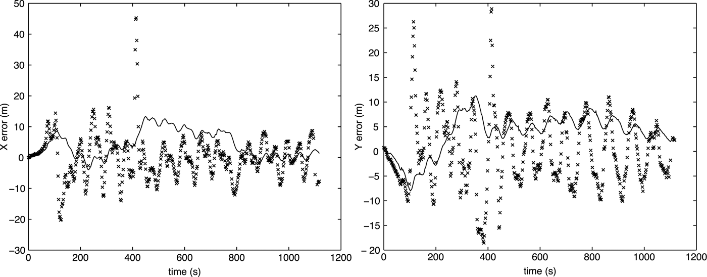
Fig. 11. SURGND surveillance: X and Y errors.

Fig. 12. SURGND surveillance: east and north velocity components errors.
From those results it is possible to conclude that:
• Measures suffer correlated errors, either due to lack of stability of aircraft flight or to navigation data processing. Navigation data are not only based on pure GPS measurements but also on the smoothing processes taking into account other airborne sensors.
• SURGND (and SURAIR) obtains a better and more stable estimate of smoothed position than raw measures, especially with respect to maximum errors.
• Measured velocity and filtered velocity are almost equal in the majority of cases, although in the times related to the “detection” of a maneuvering condition by IMM; this filter tends to develop slightly higher biases. The key aspect here is velocity is considered as a very good measurement by the filter, which tends to assume it is better not to smooth it.
Finally, regarding messages delays, in the central part of this flight, results in Fig. 13 were obtained.

Fig. 13. SURGND surveillance: filtering delay and measurement periodicity error.
The delay between measurement compilation at NAVAIR and processing at SURGND is depicted in continuous line. Most of the delay samples are between 0.15 and 0.35. This is due to the combination of several effects:
• An average communication delay of around 0.15 s, slightly higher than the simulated one, which was in the order of 0.12 s.
• Random jittering terms due to communications.
• A drift between GPS time and asynchronous SURAIR activation time. NAVAIR GPS measures are obtained with a periodicity of 0.2 s. So, depending on the relative phases of both clocks, the error changes; this accounts for an additional delay between 0 and 0.2 s.
This latter effect can be observed by measuring a periodicity error as the difference between ADS–B messages timestamp first difference and the nominal 2 s period. It is depicted in Fig. 13 as a dotted line. Every 100–300 s, the actual period changes from 2 to 2.2 s, as the drift makes SURAIR jump over a GPS sample and, simultaneously, the complete communication delay is reduced.
Finally, although not visible in the presented results, while the aircraft was on aerodrome surface there was a not-negligible probability of losing measurements or receiving them with much higher delay. The problem was related with communication overload conditions prior to aircraft take off, when many initialization data were provided to the aircraft.
IX. CONCLUSION AND FUTURE WORK
This paper details the experimental development of an air–SURGND system integrated in ATLANTIDA system. Our simulated and real data show that it will fulfill even the most demanding surveillance accuracy requirements (see, for instance [Reference Besada, García, de Miguel, Berlanga, Molina and Casar13]). Typical requirements regarding update rate for the controllers are in the range of one update every 4–5 s. Radar-based systems surveillance accuracy is not homogeneous in radar coverage, with typical error RMS for non-maneuvering conditions in the order of 100 m and in the order of 250–500 m for maneuvering conditions. Bearing error RMS in the order of 10° in maneuvers is also typical.
Some key features of the proposed experimental deployment are:
• Support for new data types of interest for TBO using advanced trajectory prediction infrastructures, especially for air-to-air trajectory negotiation, such as intent, dynamic state, aircraft configuration, etc.
• Air inclusive SWIM-integrated communications, with ADS–B using a safer and more predictable communication channel.
• Integration in a complete prototype ATM system (ATLANTIDA). Specifically, SURGND has been integrated in an adapted version of operational surveillance system (AIRCON®) and with traffic management tools.
• Experimental approach, enabling data recording for analysis and integration in simulated environment.
• SURAIR integrated in a low-cost PC-based avionics platform, including a satellite-based navigation system, a fully automated flight management system, data recording support, and an emergency and alert support system, among other features.
Regarding future research lines, the following ideas may drive enhancements of aircraft surveillance system using a SWIM infrastructure:
• Extension of SURAIR applications, especially those related to coordinated maneuvers and delegation of responsibility to aircraft pilots.
• Extension of the use of intent information to reduce prediction error in maneuvers. Reduced versions of aircraft intent could be used for this extrapolation, enabling better short-term conflict alerting systems. Of course, this demands the higher integrity in the ADS–B provided intent, which should be completely coherent with actual operations performed by FM to control the aircraft operation, therefore enabling an accurate extrapolation of the trajectory to short time intervals. Aircraft intent description language, as described in [Reference Lopez-Leones, Vilaplana, Gallo, Navarro and Querejeta8], has demonstrated in ATLANTIDA project to be a suitable intent description format for this and other trajectory prediction applications.
• Increase of adaptability of surveillance to context and traffic information. Mechanisms as the one proposed in ATLANTIDA to control messages periodicity, coupled with management procedures relating surveillance performance to higher level systems requirements (short-term conflict alerts, flight plan conformance monitoring, etc.), might serve to adapt ADS–B periods to current traffic situation. So, for instance, potentially problematic areas could have increased data rates.
• Definition of enhanced ground-based and air-based short-term alerting systems to improve the overall safety of traffic. It should be emphasized, though, that from a safety perspective, it is important to maintain ACAS, which could be enhanced using ADS–B measurements, as an independent on-board safety function, fully decoupled from short-term conflict alert in ground ATC.
Finally, it is clear that ADS–B must be extended to include new information supporting accurate trajectory prediction to enable new applications. The final format of the intent/trajectory information to be interchanged is directly related to the negotiation procedures in the ATM system. In addition, it is clear that the use of air inclusive SWIM does not preclude the possibility to have high-quality surveillance. The additional overload in communications can be compensated by the increase in reliability and capability to manage the actual load of the communication channel.
ACKNOWLEDGEMENT
INDRA S.A has co-funded the research in this paper, under Spanish Science and Innovation Ministry ATLANTIDA project within the CENIT R&D program. Additionally, this work has been supported by the Government of Madrid under grant S2009/TIC-1485 (CONTEXTS) and by the Spanish Ministry of Science and Innovation under grants TEC2008-06732 and TEC2011-28626.
 Dr Juan A. Besada is an Associate Professor in Universidad Politécnica de Madrid. He received his Ph.D. from the same University in 2001. He has been working with GPDS-SSR department since 1995. His main interests are air traffic control and management, data fusion, pattern analysis, optimization, and localization technologies. He has been working in many national and international projects, in cooperation with industrial partners, such as INDRA, AENA, Eurocontrol, Boeing R&TE, etc., on the application of new technologies to their operational systems.
 Dr Gonzalo de Miguel Vela received his Telecommunication Engineering degree in 1989 and Ph.D. in 1994 from the Universidad Politécnica de Madrid. He is currently a Professor at the Department of Signals, Systems, and Radiocommunications of this university and is a member of the Data Processing and Simulation Research Group at the Telecommunication School. His fields of interest and activity are radar signal processing and data processing for air traffic control applications.
 Ana M. Bernardos is an Assistant Professor in the Telecommunications School of the Universidad Politécnica de Madrid. Since 2005, she has been conducting research in technologies for data fusion, surveillance, smart spaces, and context-aware services. Her current research interests lies at the intersection of ubiquitous computing, human–computer interaction, and data fusion. In these areas, she has co-authored more than 50 articles and participated in relevant cooperative research projects. Ana holds a Ph.D. in “Communications Technologies and Systems”, a master's degree in “Telecommunication Engineering”, and a postgraduate diploma in “Economy and Innovation Management”.
 Professor José R. Casar graduated in Telecommunication Engineering in 1981 and obtained a Ph.D. degree in 1983 from the Universidad Politécnica de Madrid (UPM), where he holds a Chair in the Department of Signals, Systems, and Radiocommunications. During 1993, he was the Vice-Dean for Studies and Research at the Telecommunications School (UPM). During 1995, he was Deputy Vice-President for Research of the UPM, from 1996 to February 2000 Vice-President for Research at the same University and Adjunct to the Rector for Strategic Programs from February 2000 to June 2004. Currently, he is Head of the Signal and Data Processing Group and of the Center for Technology Diffusion at UPM. He has been member or president of a number of research evaluation committees and member of the board of directors of several companies. He has published more than 200 papers and led more than 70 financed research projects.


