


1. Introduction
The Silurian reefs in the Baltic Sea region were first described on the Swedish island of Gotland by Murchison (Reference Murchison1847). Since then, Gotland has increasingly attracted geological interest as the island with one of the finest and most extensive developments of Silurian reefs in the world.
Apart from on Gotland, Silurian reefs are also exposed east of the Baltic Sea in Estonia (Riding, Reference Riding and Toomey1981; Nestor, Reference Nestor, Lathiliere and Geiser1995). They have also been penetrated by several drillings further south in Latvia and Lithuania (Nestor, Reference Nestor, Lathiliere and Geiser1995; Lapinskas, Reference Lapinskas, Suveizdis and Zdanaviciute1998) and traced abundantly in seismic recordings offshore E and SE of Gotland (Flodén, Reference Flodén1980; Flodén et al. Reference Flodén, Söderberg, Tuuling, Wahlberg and Mojski1995, Reference Flodén, Bjerkéus, Tuuling and Eriksson2001; Bjerkéus & Eriksson, Reference Bjerkéus and Eriksson2001). The stratigraphic position and lateral distribution of Silurian reefs around the Baltic Sea reveal several up to 10-km-wide reef tracts (see Nestor, Reference Nestor, Lathiliere and Geiser1995, fig. 2). Bending from Gotland over Estonia towards Latvia and Lithuania, the SSW migration of these tracts reflects the development of the Baltic Silurian Basin (BSB), following changes in its configuration and facies zonation (Kaljo & Jürgenson, Reference Kaljo, Jürgenson and Kaljo1977; Nestor & Einasto, Reference Nestor, Einasto, Raukas and Teedumäe1997).
In order to study the Palaeozoic rocks below the central Baltic Sea, a dense pattern of seismic profiles were shot during the Swedish–Estonian project in marine geology between Hiiumaa–Saaremaa and Gotska Sandön–Gotland during 1990–2004. This work revealed an abundance of reef structures. However, only the uppermost Ordovician reefs have been described so far (Tuuling & Flodén, Reference Tuuling and Flodén2000, Reference Tuuling and Flodén2007), as the seismic correlation scheme for the offshore Silurian strata was only established in recent years (Tuuling & Flodén, Reference Tuuling and Flodén2009a , Reference Tuuling and Flodén2011). Based on that scheme, the Silurian reefs, their stratigraphic position, distribution, size and morphology off Saaremaa are discussed in this paper.
2. Geological background
2.a. Tectonic setting of the BSB
Located close to the western margin of the northerly drifting Baltica continent, the Baltic region was occupied by a shallow cratonic sedimentary basin during much of the Early Palaeozoic (Nestor & Einasto, Reference Nestor, Einasto, Raukas and Teedumäe1997; Baarli et al. Reference Baarli, Johnson, Antoshkina, Landing and Johnson2003; Fig. 1). Extension, configuration, seabed morphology, sedimentary evolution as well as connectivity of this basin to the closing Iapetus Ocean to the west and Tornquist Sea to the SW was largely controlled by the progressing Caledonian Orogeny, i.e. by the ongoing collision between Laurentia and Baltica continents.

Figure 1. Tectonic setting of the study area with approximate distribution of the Silurian basin on the Baltica continent (after Baarli et al. Reference Baarli, Johnson, Antoshkina, Landing and Johnson2003). TTZ: Teisseyre–Tornquist Zone; STZ: Sorgenfei–Tornquist Zone; TESZ: Trans-European Suture Zone; SG: Skagerrak Graben; OG: Oslo Graben.
By Silurian time, when Baltica reached southerly equatorial latitudes, an intracratonic depression (the Baltic Syneclise) was evolving in about the present southern Baltic Sea (Fig. 2). Warping around this depression resulted in a NE-expanding embayment that inundated the present Baltic countries. This tongue-like protrusion, called the Livonian Tongue, formed the hub of the BSB (Fig. 2). At the beginning of its development, the Livonian Tongue reached the peripheral areas of the present Baltic Shield (Fig. 1). However, due to the rising shield and subsiding syneclise, a gradual SSW regression and thus shrinkage of the Livonian Tongue across Estonia dominated throughout the Silurian.

Figure 2. Extension and facies belts of the late Wenlock (Jaagarahu–Rootsiküla time within the nassa Biozone) Livonian Tongue (modified from Kaljo et al. Reference Kaljo, Nestor and Einasto1991). See text and Figure 3 for details of the numbering of facies belts.
2.b. Facies zonation and reef facies in the BSB
As a result of differentiated tectonic movements, a distally steepening basinal slope with distinctly separated shallow and deep shelf areas (Figs 2, 3) had developed by the onset of the Silurian along the Baltic Shield–Baltic Syneclise transect (Nestor, Reference Nestor, Kaljo and Nestor1990, Reference Nestor, Lathiliere and Geiser1995; Nestor & Einasto, Reference Nestor, Einasto, Raukas and Teedumäe1997; Tuuling & Flodén, Reference Tuuling and Flodén2009a ). This seabed morphology governed the distribution of sediment types, including the growth and spreading of reef structures in the BSB.

Figure 3. Facies model with the numbered (1–5) facies belts of the Baltic Silurian Basin (modified from Nestor & Einasto, Reference Nestor, Einasto, Raukas and Teedumäe1997) plotted on the southern slope of the Baltic Shield (shallow shelf)–Baltic Syneclise (deep shelf) transect. For lateral distribution of facies belts 1–5 see Figure 2.
Five facies zones have been distinguished in the BSB (Nestor, Reference Nestor, Kaljo and Nestor1990; Nestor & Einasto, Reference Nestor, Einasto, Raukas and Teedumäe1997; Figs 2, 3). The lagoon–tidal flat, the shoal and the open shelf facies belts (1–3 in Figs 2, 3) were located on the uplifted slope of the Baltic Shield where they formed a shallow-water carbonate shelf. On the transitional slope and in the deep shelf area in the Baltic Syneclise (facies belts 4, 5 in Figs 2, 3), mainly hemipelagic argillaceous sediments accumulated (Kaljo et al. Reference Kaljo, Nestor and Einasto1991).
In the BSB, the most favourable conditions for proliferation of various reef-building organisms occurred in the middle of the broad carbonate shelf, i.e. within the high-energy shoal area up to a depth of 10–12 m (Nestor, Reference Nestor, Lathiliere and Geiser1995; Fig. 3). The reef facies with bioherms, biostromes and banks is normally replaced by open shelf biomicritic limestones and by lagoonal or restricted shelf dolomitic rocks basinwards and shorewards in the BSB, respectively (Figs 2, 3).
In the Gotland area, the largest Wenlock and Ludlow reefs with a coral-stromatoporoid carcass locally form extensive low shoal or barrier complexes (Manten, Reference Manten1971; Riding, Reference Riding and Toomey1981; Flodén, Reference Flodén1980; Flodén et al. Reference Flodén, Söderberg, Tuuling, Wahlberg and Mojski1995, Reference Flodén, Bjerkéus, Tuuling and Eriksson2001). The locations of the barriers changed concomitantly with the recurrent transgressions and regressions (Flodén et al. Reference Flodén, Bjerkéus, Tuuling and Eriksson2001). The most favourable conditions for the formation of organic build-ups and shoal barriers were established during the regressions that followed significant pulsatory transgressions (Riding, Reference Riding and Toomey1981; Klaamann & Einasto, Reference Klaamann, Einasto, Kaljo and Klaamann1982). In the mainly regressive BSB, the SSW-migrating shoal reefs and reef barriers are normally underlain by nodular open shelf limestones and overlain by lagoonal, often primary dolomites (Riding, Reference Riding and Toomey1981; Nestor & Einasto, Reference Nestor, Einasto, Kaljo and Klaamann1982; Flodén et al. Reference Flodén, Bjerkéus, Tuuling and Eriksson2001; Fig. 3).
2.c. The Silurian sequence, facies distribution and reefs on Saaremaa
Lying on the elevated southern slope of the Baltic Shield, Estonia remained in the shallowest NE corner of the Livonian Tongue (Figs 1–3). Due to the equatorial conditions and the high structural setting, a shallow-water carbonate shelf facies mainly prevailed here. Spanning from the lowermost Llandovery to the uppermost Pŕidoli layers, the Silurian sequence in Estonia is divided into ten units: Juuru, Raikküla, Adavere, Jaani, Jaagarahu, Rootsiküla, Paadla, Kuressaare, Kaugatuma and Ohesaare regional stages.
In accordance with the above-described facies zonation, all stages deepen from north to south, i.e. gradually thicker and more argillaceous lithological units replace each other towards the Baltic Syneclise. Similar N–S lithofacies transects appear more sharply in the Llandovery (Juuru, Raikküla and Adavere stages), but particularly in the lower part of the Wenlock (Jaani and Jaagarahu stages; Fig. 4) when the distally steepening basinal slope still crossed the present Estonian territory. On the basis of this feature various Silurian lithostratigraphic units (beds, members and formations) have been distinguished in Estonia; each unit usually characterizes one facies belt within a stage (Nestor, Reference Nestor, Raukas and Teedumäe1997; Tuuling & Flodén, Reference Tuuling and Flodén2011, fig. 3; Fig. 4).

Figure 4. Combined N–S (litho)stratigraphic Wenlock–Přidoli cross-section along the western coast of Saaremaa (modified after Nestor, Reference Nestor, Raukas and Teedumäe1997, figs 69, 73; Tuuling & Flodén, Reference Tuuling and Flodén2011, fig. 3) with its seismic subdivision, correlation and reef distribution offshore. Mb: member; Fm: formation; B: bed. For location of section see Figure 6.
Unlike the Estonian mainland and the island of Hiiumaa (Aaloe & Nestor, Reference Aaloe, Nestor and Kaljo1977; Nestor & Nestor, Reference Nestor and Nestor1977; Nestor, Reference Nestor, Lathiliere and Geiser1995), Llandovery reefs have not been detected on Saaremaa or below the Baltic Sea offshore Saaremaa, where at that time an open shelf facies dominated. The first occasional small reefs appear on Saaremaa in the biomicritic limestones of the Ninase Member of the Jaani Stage (Aaloe & Einasto, Reference Aaloe, Einasto and Kaljo1970; Fig. 4). However, it was not until the beginning of Jaagarahu time, after the significant earliest Wenlock regression, that a high-energy shoal environment favourable for reef growth spread widely across northern Saaremaa (Fig. 4).
Due to constant southwards regression and infilling of the BSB, the lagoonal-littoral facies became increasingly dominant all over Saaremaa towards the end of Wenlock (Figs 2, 4). At that time, the shoal facies only reached Saaremaa during short transgressions. A series of upwards shallowing cycles with shoal to lagoonal-littoral sediments, often bracketed by discontinuity surfaces, therefore characterizes the Jaagarahu and Rootsiküla stages on Saaremaa (Fig. 4). A slight deepening on Saaremaa occurred again at the beginning of Ludlow. As a result the uppermost and lowermost parts of the Paadla Stage, being divided by a lagoonal-littoral set of layers, are represented by shoal facies. All cycles in the Jaagarahu and Rootsiküla stages and facies units in the Paadla Stage are distinguished as separate lithostratigraphic units, named beds (Fig. 4).
Three shallowing-upwards lithological cycles (the Vilsandi, Maasi and Tagavere beds) are distinguished in the Jaagarahu Stage. The high-energy shoal complex of the Vilsandi Beds forms the richest reef unit in Estonia (Fig. 4), where lenticular to stock-like bioherms with a coral-stromatoporoid carcass can reach up to a few kilometres in diameter and more than 10 m in thickness (Rõõmusoks, Reference Rõõmusoks1983). So far, no reefs have been discovered in the Maasi and Tagavere beds on Saaremaa. Likewise, the shoal facies portions in the upwards-shallowing Viita, Kuusnõmme, Vesiku and Soeginina beds of the Rootsiküla Stage do not contain any reefs on Saaremaa. The reef structures appear again in the Sauvere and Uduvere beds, forming respectively the lowermost and the uppermost shoal facies portions in the Paadla Stage (Fig. 4).
During a short latest Ludlow to earliest Přidoli transgression, Saaremaa was once again inundated by an extensive shallow-shelf sea. However, considering the post-Silurian erosional cut, the youngest portion of the Silurian sequence (Kuressaare, Kaugatuma and Ohesaare stages), which is preserved only in southernmost Saaremaa, is largely represented by open shelf sediments void of reef structures.
3. Methods and material
The Estonian offshore area, previously inaccessible USSR territory, was of high priority in planning the seismic survey. Furthermore, this area borders the best-studied Palaeozoic sequence in terms of lithology, stratigraphy and facies relationships. Equipment choice and profile location distinguishes two prime datasets collected respectively during 1990–1996 and 1999–2004.
3.a. Equipment utilized
An analogue single-channel seismic reflection profiler, described earlier by Flodén (Reference Flodén1980, Reference Flodén1981), Tuuling (Reference Tuuling1998) and Flodén et al. (Reference Flodén, Bjerkéus, Tuuling and Eriksson2001), was used during the first period. A pneumatic acoustic repeater (PAR) 1600B air-gun source and a 50-element hydrophone ‘eel’ were utilized. Two frequency bands, 100–200 Hz and 250–500 Hz, were filtered from the registered signal and displayed on separate EPC (Edward P. Curely Laboratories Inc.) precision graphic recorders across a 0.5 s time interval. The higher-frequency superior resolution recordings (maximum up to 5 m) were the primary basis for seismic interpretation.
For the second survey, a Meridata digital multi-mode sonar system on a computer was used (see details in Tuuling & Flodén, Reference Tuuling and Flodén2007). The reflected air gun pulse was received with a 16 m hydrophone ‘eel’, consisting of 100 elements coupled in parallel. The unfiltered and unprocessed signal was recorded using the Meridata software package SView and later processed, filtered and finally displayed on an EPC graphic recorder at the frequency range of 100–1000 Hz.
3.b. The seismic dataset
To optimize visualization of the structural setting of the Palaeozoic rocks, a grid with two directions was performed across the northern Baltic Proper. Initially (during 1990–1996), a N–S survey pattern was designed to simplify the interpretation and correlation of data across the sublatitudinal stripes of the Palaeozoic units cropping out on the seafloor (Figs 5, 6). This set was complemented in the summers of 1999–2004 with NE–SW profiles, running nearly parallel to the strike of the slightly (10–15ʹ) SE-dipping Palaeozoic strata across the northern Baltic Proper (Tuuling & Flodén, Reference Tuuling and Flodén2009b , fig. 4; Figs 5, 6).

Figure 5. Map of the seismic lines shot in 1990–2004 in and around the study area. Sections of the seismic lines A–G are displayed in Figures 7–13, respectively.
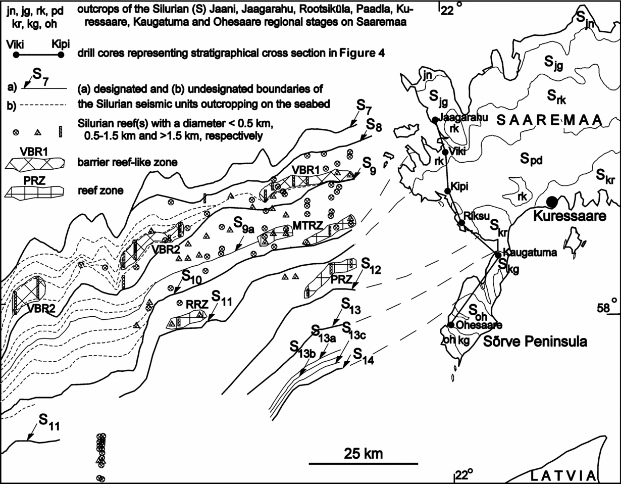
Figure 6. Geological map showing the sublatitudinal stripes of the outcropping and southwards-younging Silurian seismic units with occurrence of the Silurian reefs off Saaremaa. VBR1 and VBR2: Vilsandi barrier-reef-like structures; MTRZ: Maasi–Tagavere reef zone; PRZ: Paadla reef zone; RRZ: Rootsiküla reef zone. See Figure 4 and text for the stratigraphic position of the designated boundaries of the seismic units cropping out.
Because of numerous E–W lithological changes, interpretation and correlation of the Silurian layers across the Baltic required a tighter dataset. Therefore, additional N–S seismic profiles were shot across the Silurian rocks cropping out off Saaremaa and Gotland in 1993 and 2004, respectively (Fig. 5).
The average distance between the N–S lines 9301–9314 and 9314–9004 covering the Silurian rocks off Saaremaa is 2.5 km and 5 km, respectively, as further towards Gotland, the lines are still 10 km apart (Fig. 5). The distance between the NE–SW profiles between Saaremaa and Gotland is c. 10 km, although only five of them (0104, 9906, 9907, 0105 and 0106) cross the area of present interest (Fig. 5).
Because of shallow unnavigable water, a 10–30-km-wide data gap exists near the shore of Saaremaa (Fig. 5). Southwards, most of the submeridional profiles were terminated near the latitude of the Irbe Strait separating the Sõrve and Courland peninsulas in Estonia and Latvia (Fig. 5). As Gotland is located a bit further south with respect to Saaremaa, our N–S set of profiles offshore Gotland covers only the northernmost part of the island (Fig. 5). As a result, instead of the uppermost Pŕidoli (Ohesaare) layers off Saaremaa (Fig. 6), only the Wenlock–Ludlow boundary (Rootsiküla–Paadla) layers were accessible in the closest profiles off Gotland (Tuuling & Flodén, Reference Tuuling and Flodén2009b , Reference Tuuling and Flodén2011).
The N–S seismic lines shot in cooperation with Lithuanian geologists from R/V Vejas in 1993 (V9306–V9311) and 1994 (V9403–V9408) crossed the area between Gotland and northern Latvia that had been poorly covered by us (Fig. 5). All noted profiles were important in establishing the distribution of Silurian reefs between Saaremaa and Gotland and helping link the results of our study with the earlier reef studies off Gotland (Flodén, Reference Flodén1980; Flodén et al. Reference Flodén, Bjerkéus, Tuuling and Eriksson2001; Bjerkéus & Eriksson, Reference Bjerkéus and Eriksson2001).
4. Silurian reefs off Saaremaa
4.a. Seismic stratigraphy and geological map of the Wenlock–Přidoli sequence off Saaremaa
Based on the distinguished seismic reflectors and units off Saaremaa (Fig. 4), a geological map was compiled (Tuuling & Flodén, Reference Tuuling and Flodén2009b , fig. 7; Reference Tuuling and Flodén2011, fig. 4; Fig. 6). All seismic units identified were named after the chrono- or lithostratigraphic units with which they correlate on Saaremaa (Figs 4, 6).
The most striking and laterally consistent seismic reflectors match distinct lithological boundaries between the Silurian regional stages: the Jaani–Jaagarahu (S8), Jaagarahu–Rootsiküla (S10), Rootsiküla–Paadla (S11), Paadla–Kuressaare (S12), Kuressaare–Kaugatuma (S13) and Kaugatuma–Ohesaare (S14) stages onshore. The rest of the distinguished reflectors (Figs 4, 6) correlate with the lithostratigraphic boundaries: S7, S9 and S9a between the Mustjala and Ninase (Jaani Stage), the Vilsandi and Tagavere (Jaagarahu Stage) and the Tagavere and Maasi beds (Jaagarahu Stage), respectively and 13a, 13b and 13c off the southernmost Sõrve Peninsula between the Lower and Upper Äigu, the Upper Äigu and Lower Lõo and the Lower and Upper Lõo beds (all in the Kaugatuma Stage), respectively.
Many reflectors further off Saaremaa are delimiting unidentified deep basinal or shallow-shelf units (depicted with dashed lines in Fig. 6) inside the Jaagarahu seismic unit (S8–S10) that are missing on NW Saaremaa (Tuuling & Flodén, Reference Tuuling and Flodén2011). Thus, seismic units S8–S9 and S9–S10 contain stratigraphic gaps increasing towards NW Saaremaa, which on Gotland correspond roughly to the Tofta lowermost Slite and uppermost Slite beds, respectively (Tuuling & Flodén, Reference Tuuling and Flodén2009b ).
4.b. Seismic correlation of the Silurian sequences between Saaremaa and Gotland
In establishing the distribution of Silurian reefs between Saaremaa and Gotland, key issues arise concerning the seismic subdivision of the Silurian sequence with the stratigraphic position of the reefs off Gotland and its correlation with the offshore area of Saaremaa. Due to deep Pleistocene glacial valleys with the Fårö and Gotland deeps, the seismic subdivision and correlation of the Silurian sequence becomes increasingly arduous and thus more tentative towards Gotland (Tuuling & Flodén, Reference Tuuling and Flodén2009a , Reference Tuuling and Flodén b , Reference Tuuling and Flodén2011). This is because of the eroded portions of bedrock within the valleys and deeps that are dismembering facies continuity, and therefore revealing a new set of reflectors.
As a result, the accessibility of reliable seismic information to extend the seismic correlation scheme of Saaremaa towards Gotland is dependent on the bedrock relief and varies to a great extent at different seismic units, reaching approximately seismic lines 9101, 9310, 9307 and 9110 for seismic units S7–S9, S9–S11, S11–S12 and S12–S14, respectively (Figs 5, 6).
4.c. Distribution of reefs off Saaremaa
Normally reefs appear in seismic recordings as geometrically distinctive structures that, compared to the surrounding rocks, cause significant velocity pull-up of the seismic pulse (Flodén, Reference Flodén1980; Figs 7–13). The larger reefs occasionally exhibit an irregular or weakly layered reflector configuration, although most of the seismic energy sometimes reflects back from the reef top, leaving a blurred area void of distinct reflectors (Flodén, Reference Flodén1980; Tuuling & Flodén, Reference Tuuling and Flodén2000).

Figure 7. Seismic profile 9302 showing major seismic reflectors S8–S11 and reef structures in the Vilsandi–Rootsiküla seismic units off Saaremaa (for location see section A in Fig. 5). VR: Vilsandi reef; VBR1: Vilsandi barrier-reef 1; MTR: Maasi–Tagavere reef; MTRZ: Maasi–Tagavere reef zone; PRZ – Paadla reef zone.

Figure 8. Seismic profile 9305 showing major seismic reflectors S7–S9 and reef structures in the Vilsandi–Tagavere seismic units off Saaremaa (for location see section B in Fig. 5). VBR1: Vilsandi barrier-reef 1; MTR: Maasi–Tagavere reef; MTRZ: Maasi–Tagavere reef zone; SK: Silurian Klint.

Figure 9. Seismic profile 9308 showing major seismic reflectors S7–S11 and reef structures in the Vilsandi–Rootsiküla seismic units off Saaremaa (for location see section C in Fig. 5). MR: Maasi reef; RRZ: Rootsiküla reef zone; SK: Silurian Klint.

Figure 10. Seismic profile 9309 showing major seismic reflectors S8–S10 and reef structures in the Jaagarahu–Rootsiküla seismic unit off Saaremaa (for location see section D in Fig. 5). VBR2: Vilsandi barrier reef 2; RRZ: Rootsiküla reef zone.

Figure 11. Seismic profile 9203 showing major seismic reflectors S8–S9a and the largest barrier-reef-like structure (VBR2) in the Vilsandi seismic unit off Saaremaa (for location see section E in Fig. 5).

Figure 12. Seismic profile 9205 showing major seismic reflectors S7–S9 and Vilsandi barrier reef 2 (VBR2) in the Vilsandi seismic unit off Saaremaa (for location see section F in Fig. 5;). SK: Silurian Klint.
Comprising pure and hard erosion-resistant limestone, reefs are often distinguished as remnant-hillocks on the seabed (Figs 7–12). On the basis of diameter, the reefs were divided into three groups (Fig. 6) prior to stratigraphic designation. According to the dimensions, morphology and frequency of occurrence of reefs, as well as their facies position and lateral extension in the basinal slope, larger reef zones and barrier-reef-like structures were distinguished (Figs 6–12).
4.c.1. The Jaagarahu reefs
As on the mainland, a majority of reefs west of Saaremaa occur in the layers that accumulated during Jaagarahu time. Compared to the island however, the reefs reveal a much larger stratigraphic spectrum offshore where they are also widespread in the Maasi and Tagavere seismic units (Figs 4, 6–9).
Normally, the submarine Jaagarahu reefs are distinguished in the seismic profiles as lenticular or slightly conical minor erosional elevations on the seafloor (Figs 7–9). They are particularly numerous in the first three seismic lines (9301–9303) off Saaremaa (Tuuling & Flodén, Reference Tuuling and Flodén2011, fig. 6; Figs 5–7). The diameter of most of the reefs that have undergone erosion remains <0.5 km, although the number of reefs >0.5 km wide increases slightly further off Saaremaa, i.e. towards the deeper part of the BSB (Fig. 6). In the Maasi and particularly in the Tagavere seismic unit, larger solitary patch reefs (>0.5 km in diameter) or clusters of smaller reefs appearing in several neighbouring profiles were interpreted as minor reef zones (MTRZ in Figs 6–8).
The most conspicuous and largest Jaagarahu reefs are however associated with two extensive NE–SW-elongated zones, which both occur in the Vilsandi seismic unit (VBR1 and VBR2 in Fig. 6). The older zone (VBR1) already appears in the first seismic line 20 km off Saaremaa (9301) and can be followed up to seismic line 9305 (Figs 5–8). This zone, in places more than 2 km wide and c. 25 km long, reveals a cluster of heavily eroded remnants of smaller, coalescent reefs in the best-preserved sections (e.g. profiles 9302 and 9305; Figs 6–8). Due to its great width to thickness ratio this zone morphologically resembles a reef bank (see Copper & Brunton, Reference Copper and Brunton1991, fig. 3). According to its stratigraphic position and location on the basinal slope, VBR1 most likely represents the westerly extension of a reef-rich belt with large solitary reefs, known in the Vilsandi Beds on the mainland.
As in modern barrier reefs, this zone has a distinctly steeper basinwards flank, as it separates the shallow-shelf plateau in the north from the gradually southwards-deepening basinal slope (Tuuling & Flodén, Reference Tuuling and Flodén2011, fig. 6; Figs 7, 8). On the shallow-shelf plateau the Vilsandi seismic unit has the least and nearly constant thickness, almost horizontal attitude and contains occasional small patch reefs (Fig. 7). In contrast, this unit is void of reefs south of the plateau and its thickness, which rises abruptly just behind the barrier reef, gradually increases along the S-dipping basinal slope (Fig. 8).
The younger and larger (c. 45 km long) reef zone in the Vilsandi layers (VBR2) is confined within an unidentified shallow-shelf seismic unit that is missing both on Saaremaa and in the closest sea area off Saaremaa (Fig. 6). VBR2 therefore emerges first as a conspicuous erosional remnant at the crest of a small escarpment in profile 9309 c. 50 km off Saaremaa (Figs 5, 6, 10). Further towards Gotland, this zone is intermittently (up to seismic line 9101) traceable as a remarkable elevation on the seabed (Figs 5, 6, 11, 12). Because of later erosion, it is divided into c. 20- and 10-km-long eastern and western segments between profiles 9309 and 9203, and 9205 and 9101, respectively (Figs 5, 6). In the best-preserved sections (e.g. profiles 9309, 9310, 9203 and 9205), this zone comprises two large consecutive lenticular reefs that are locally more than 2 km wide (Figs 10, 11, 12). In all, the maximum total width of VBR2 (profile 9203) can reach c. 8 km (Fig. 11).
Indeed, these large solitary successive lenticular reef bodies, separated by a narrow erosional depression, are the largest reef structures and together form the widest reef zone encountered so far in the northern Baltic Proper. As for VBR1, VBR2 marks some sort of brake in the bottom morphology of the BSB. It has a steeper and regularly basinwards-deepening fore-reef side that is covered by seismic units gradually thickening in the same direction (Fig. 11). Shorewards, i.e. on the back-reef side, the seismic unit bracketing VBR2 is often largely eroded, together with some underlying older units. The landward side of VBR2 is therefore distinguished in the seafloor, particularly in bedrock relief, often as a small escarpment with a slight depression in front of it (Figs 10–12).
4.c.2. The Rootsiküla and Paadla reefs
Unlike the Jaagarahu layers, the Rootsiküla and Paadla seismic units off Saaremaa include rare reefs within very limited areas (Fig. 6). As on Saaremaa, no reefs were detected in the Rootsiküla layers in the nearshore area. They appear only in a few profiles c. 60–70 km off Saaremaa (Fig. 6). Seismic lines 9308 and 9309 both show a symmetrical mamelon-like patch reef nearly 1.5 km in diameter close to the southernmost limit of the outcropping Rootsiküla seismic unit (Figs 5, 6, 9, 10). A smaller, slightly asymmetrical patch reef appears just west of them in profile 9214. This row of three closely spaced larger reefs was interpreted as a small reef zone in the Rootsiküla layers (RRZ in Figs 6, 9, 10).
In contrast to the Rootsiküla seismic unit, the reefs in the Paadla layers were revealed by the seismic data available from the closest area off western Saaremaa. Three small patch reefs emerge near the NE extremity of the seismic line 9111 (Figs 5, 6). Slightly westwards, a remnant of a larger and heavily eroded reef appears in three neighbouring N–S seismic lines (9301–9303), which was interpreted as a reef zone (PRZ in Figs 6, 7). Paadla reefs in these profiles mark a distinct change in the present bottom morphology (see Tuuling & Flodén, Reference Tuuling and Flodén2011, fig. 6; Fig. 7), which is obviously due to different hardness and erosion resistance of the rocks that are exposed north and south of them. A calcareous-rich, harder and erosion-resistant shoal and lagoonal facies with numerous reefs (Jaagarahu, Rootsiküla and Paadla seismic units) therefore forms the seabed north and a more argillaceous, i.e. softer and easily erodible open-shelf facies void of reefs (Kuressaare, Kaugatuma and Ohesaare seismic units), south of this reef zone. Additionally, only two Paadla reefs were detected in the closest vicinity of Saaremaa: two large patch reefs immediately NW of the PRZ in profiles 9304 and 9207 (Figs 5, 6).
Several swarms of smaller, conical Ludlow reefs, possibly of Paadla age, appear some 70–90 km further SW of the PRZ in the seismic lines 9101, 9103, V9403 and V9404 in the mid-Baltic Sea, between northern Latvia and Gotland (Figs 5, 6, 13, 14). However, most of them remain beyond the limits of our study area (Fig. 6). They might be considered as prolongations of the reef-rich zones described earlier off Gotland (Flodén, Reference Flodén1980; Bjerkéus & Eriksson, Reference Bjerkéus and Eriksson2001; Fig. 14) and will therefore be considered briefly while discussing the distribution of Silurian reefs between Gotland and Saaremaa.

Figure 13. Seismic profile V9404 showing a swarm of small conical haystack-like reefs in the assumed Paadla layers in the middle of the Baltic Sea between northern Latvia and Gotland (for location see section G in Fig. 5;). PR: Paadla reef.

Figure 14. Distribution of the Silurian reefs plotted with respect to the bedrock relief changes and locations of the seismic lines 9310 and 9101 between Saaremaa and Gotland. B1: Klinteberg reef barrier; B2: Östergarn (Hemse Formation) reef barrier; B3: Milleklint (Hemse Formation) reef barrier; B4: Sundre reef barrier (after Flodén, Reference Flodén1980; Bjerkéus & Eriksson, Reference Bjerkéus and Eriksson2001; Flodén et al. Reference Flodén, Bjerkéus, Tuuling and Eriksson2001). See Figure 4 and text for the stratigraphic position of the designated boundaries of the outcropping seismic units on the seabed.
No reefs were detected in the Kuressaare, Kaugatuma and Ohesaare seismic units off Saaremaa.
5. Discussion
A sufficient density of seismic profiles provides an adequate overview of the stratigraphic and lateral distribution, as well as the morphology and dimensions of Silurian reefs off Saaremaa. This considerably enhances the earlier mainland-derived scarce knowledge and helps to specify the dynamics and trends in the development of the Silurian shallow-shelf facies in the NE corner of the BSB.
5.a. General trends and dynamics in reef distribution off Saaremaa
The rocks that crop out at the western coast of Saaremaa are also exposed on the seafloor near the island (Tuuling & Flodén, Reference Tuuling and Flodén2011). Indeed, the general distribution of reefs off Saaremaa (both the stratigraphic pattern and lateral trends) follows those on the island. The dynamics in reef distribution, i.e. their NE–SW repeated migration in time, reflects first of all alternating transgressive–regressive cycles in the BSB.
Both in the onshore and offshore areas, the highest concentration of reefs occurs in the Jaagarahu Stage (Figs 6–8, 14). However, unlike on the mainland where the reefs occur only in its basal unit (Vilsandi Beds), off Saaremaa they are widely spread in the overlying Maasi and Tagavere seismic units. Furthermore, in the offshore area the Jaagarahu layers revealed two extensive reef structures formed along an ill-defined scarp in the shallow shelf (VBR1 to VBR2 series in Fig. 6), which largely resemble modern barrier reefs. They both mark a distinct facies boundary in the Vilsandi seismic unit, separating a shallow-shelf area with the thinnest and nearly constant thicknesses of reef-rich layers in the north from southerly sloping and thickening seismic units void of reefs. Indeed, these reef zones seem to mark a morphological break in the seafloor (Figs 8, 11–12) which, during earliest Jaagarahu time, separated the shallowest flat-lying back-reef and the southerly sloping and deepening fore-reef areas.
The SW shift of this barrier reef follows the regressing shoreline and shallowing Silurian basin during Vilsandi time. The stratigraphic gap along the top of the Vilsandi Beds on and off northern Saaremaa (Nestor, Reference Nestor, Raukas and Teedumäe1997; Tuuling & Flodén, Reference Tuuling and Flodén2011) allows us to suggest that these areas became exposed for a subaerial erosion during this regression. As sea level fell and the shoreline gradually approached this barrier, the fore-reef area became progressively shallower and calmer. Still, it held sufficient accumulation space to preserve abundant sediments derived from the progressively exposed mainland and back-reef areas. As a result, the southerly sloping fore-reef area filled up regularly and was smoothed and prograded towards the SSW. A widening and flattening shallow-shelf pattern is well documented in the Jaagarahu sequence both on (Nestor & Einasto, Reference Nestor, Einasto, Raukas and Teedumäe1997) and off (Tuuling & Flodén, Reference Tuuling and Flodén2011) Saaremaa.
In the course of short transgressive cycles during Maasi and Tagavere time, the environment supporting patch-reef growth migrated repeatedly back to the closest vicinity of Saaremaa. However, due to great changes in the seabed morphology, the conditions for formation of a barrier-reef-like structure nearby Saaremaa had become unfavourable, and were most likely never re-established there. Moreover, the progressing progradation during the Late Wenlock widened and flattened the shallowing-up shelf area until the shallow-shelf edge with a bathymetric break migrated to a position south of present Saaremaa (Fig. 2). This resulted in considerable shrinkage of the shoal, open-shelf and slope facies zones, whereas the poor reef growth and associated sparse lagoonal-littoral and even subaerial conditions became widespread in the onshore and close to offshore areas of Saaremaa (Nestor & Einasto, Reference Nestor, Einasto, Raukas and Teedumäe1997; Fig. 2). As a result, the first reefs in the Rootsiküla layers emerged only c. 75 km off Saaremaa (Figs 6, 9, 10).
Despite the following Ludlow – earliest Pŕidoli transgressions that repeatedly restored a slightly deeper shoal environment around western Saaremaa, the growth of reefs in that area never reached the same extent and dimensions as in Jaagarahu time. Still, the frequency of the minor shallow-shelf Paadla reefs in the closest vicinity of Saaremaa (profile 9111) may be considerable (Figs 5, 6, 14).
The conditions for reef proliferations in the NE corner of the BSB worsened significantly after the short but extensive latest Ludlow – earliest Pŕidoli transgression. The reef growth in this area practically ceased and no reefs have been discovered in the layers younger than the Paadla age, either on or off Saaremaa. This is despite the fact that, in the Kuressaare, Kaugatuma and Ohesaare stages which are preserved only around southern Saaremaa, the open shelf facies varieties make up the overwhelming majority.
Worldwide decline in the size and extent of reef complexes during the Ludlow and their disappearance in most places in the Pŕidoli are well known (Copper & Brunton, Reference Copper and Brunton1991). This tendency may reflect the growing isolation of the shallowest and deeply-intruding (into the continental hinterland) parts of the Livonian Tongue in connection with the closure of the Iapetus Ocean towards the end of the Silurian period. In remote cratonic interior settings, the increase in isolation together with the warming equatorial conditions and intensifying evaporation might have been enhanced, thus degrading salinity conditions for the reef growth. Further, the culminating Caledonian Orogeny with rising land areas undoubtedly intensified erosion and boosted influx of the terrigenous component into the BSB. As a result, carbonate sedimentation has became heavily diluted since late Ludlow Kuressaare time, both in the open shelf and even in the shoal areas of the NE BSB (Nestor & Einasto, Reference Nestor, Einasto, Raukas and Teedumäe1997).
Along with blurring the facies zonation, the abundance of argillaceous admixture severely smothered reef development across the entire shallow shelf area of the Livonian Tongue. During short shallowing stages, the shoal facies however rejuvenated cyclically with an abundance of various organisms as up to 3–5-m-thick layers full of crinoidal debris were deposited during Kaugatuma time around SW Saaremaa. Some authors think that these impressive crinoidal grainstone layers may even be of fore-reef origin, i.e. accumulated along the basinwards margins of large reef bodies (Einasto, Reference Einasto, Kaljo and Nestor1990). However, we do not as yet have any other indications to confirm that the latest Ludlow and Pŕidoli shoal facies, which have been largely eroded from Saaremaa, could have contained any large reef bodies.
Furthermore, evidence of reefs from that time interval is very rare in the entire Baltic region. The Hamra–Sundre reef units on southernmost Gotland which, according to conodont-based correlation, correspond to the Kuressaare Stage on Saaremaa (Jeppsson et al. Reference Jeppsson, Viira and Männik1994), are the only known latest Ludlow reefs exposed on the mainland. Seismic data however reveal the Sundre reefs immediately east (Flodén, Reference Flodén1980; Flodén et al. Reference Flodén, Bjerkéus, Tuuling and Eriksson2001) and Pŕidoli reefs 100 km SE (Bjerkéus & Eriksson, Reference Bjerkéus and Eriksson2001) of southern Gotland in the Baltic Sea. Four reefal units have been recognized in the late Ludlow – early Pŕidoli layers near the centre of the Baltic Syneclise in Lithuania and Latvia (Lapinskas, Reference Lapinskas, Suveizdis and Zdanaviciute1998; Zdanaviciute & Lazauskiene, Reference Zdanaviciute and Lazauskiene2007).
The Silurian sequence, which is 436 m thick on Saaremaa, is c. 750 m thick, more complete and with fewer discontinuities on Gotland (Jeppsson et al. Reference Jeppsson, Eriksson and Calner2006), only 150 km further towards the continental margin in the SW. Moreover, a deeper sedimentary environment on Gotland is obvious from the increased role of shoal and open-shelf facies richer in argillaceous component (Bassett et al. Reference Bassett, Kaljo, Teller, Holland and Bassett1989; Jeppsson et al. Reference Jeppsson, Viira and Männik1994). In contrast to Gotland, the conditions for reef development around Saaremaa in the much shallower water near the ancient shoreline were therefore more severely influenced by regressive–transgressive cycles, or even minor sea-level fluctuations in the BSB. The distribution of reefs around Saaremaa is therefore more stratigraphically restricted and controlled by episodic events. In the slightly deeper-water environment on Gotland, which is closer to the continental edge and more accessible to open ocean, reefs of varying quantity, morphology and magnitude are however widespread in nearly all Wenlock and Ludlow formations exposed on the island (Manten, Reference Manten1971; Riding, Reference Riding and Toomey1981; Neuman & Kershaw, Reference Neuman and Kershaw1991; Fig. 14).
5.b. Post-Silurian (Pleistocene glacial) erosion of reefs between Saaremaa and Gotland
In general, distinctly opposite trends are observed in the occurrence of reef facies onshore and offshore Saaremaa and Gotland. On Saaremaa, the frequency and magnitude of reefs increase clearly towards offshore areas, whereas the number, extent and magnitude of the reefs around Gotland are remarkably greater on than off the island.
At the same time, the comparison of conodont faunas between Saaremaa and Gotland reveals only moderate deepening with consistent facies zones, as not a single conodont collection on Saaremaa is outside the range of variation found or expected in the eastern facies on Gotland (Jeppsson et al. Reference Jeppsson, Viira and Männik1994). Many significant changes in the seabed morphology with distinct differences in the facies and faunas appear first between eastern and western Gotland (Martinsson, Reference Martinsson1967; Jeppsson et al. Reference Jeppsson, Viira and Männik1994). We therefore suggest that in the gradually deepening Silurian basin between Saaremaa and Gotland, Wenlock and Ludlow reefs were flourishing to a much larger extent than it appears today.
Indeed, the primary distribution pattern of Silurian facies between Saaremaa and Gotland has obviously been destroyed by later erosion, particularly by glacial erosion in the Pleistocene (see Tuuling & Flodén, Reference Tuuling and Flodén2011, fig. 14). E–W changes in the bedrock relief with corresponding disruptions in the facies continuity appear most clearly in the Jaagarahu layers, which constitute the best-covered seismically and thus the best mapped and explored stratigraphic unit between Saaremaa and Gotland (Tuuling & Flodén, Reference Tuuling and Flodén2009a , Reference Tuuling and Flodén b , Reference Tuuling and Flodén2011; Fig. 14). The shallow-shelf shoal Jaagarahu subunits with numerous mounting reefs on the seafloor are therefore exposed east of seismic line 9310 (Fig. 14). West of the latter line, however, the deep glacial valleys in the bedrock relief (see Tuuling & Flodén Reference Tuuling and Flodén2011, fig. 14; Fig. 14) exhume deeper open shelf and slope facies varieties of Jaagarahu layers void of reefs. Only the segments of the largest barrier-reef-like zone VBR2 are preserved further westwards between these valleys up to seismic line 9101, before this zone is terminated by the largest and deepest (>200 m below sea level) erosional depression just NE of Gotland: the Fårö Deep (Tuuling & Flodén, Reference Tuuling and Flodén2001, Reference Tuuling and Flodén2011; Fig. 14).
Taking into account the conodont-based correlation of the Silurian sequences between Saaremaa and Gotland (Jeppsson et al. Reference Jeppsson, Viira and Männik1994), the Högklint Beds with large reef bodies on northern Gotland can be considered as the coeval westerly equivalent of the Vilsandi Beds on Saaremaa. Hence, the reef-rich VBR2 zone may once have extended to Gotland. Consequently, the deep glacier valleys and the Fårö Deep NE of Gotland, bracketed with large reef bodies, have exposed highly argillaceous and reef void deeper facies equivalents of the Högklint, Tofta and Slite beds and likewise the Llandovery rocks, constituting an overwhelming part of the subsurface Silurian sequence on northern Gotland.
Compared to the Jaagarahu layers, the latest Wenlock and Ludlow reefs on and off Saaremaa are considerably smaller in number and size (Figs 6, 14). On Gotland, however, both onshore and offshore, they are numerous (Fig. 14) and their variations in size and morphology also reveal distinct differences between the wave-agitated high-energy and low-energy reefs, the latter developed below the wave base (Riding, Reference Riding and Toomey1981; Flodén et al. Reference Flodén, Bjerkéus, Tuuling and Eriksson2001). Limitations of the seismic dataset with highly varying bedrock relief unfortunately preclude precise seismo-stratigraphic control and thus correlation of the latest Wenlock and Ludlow reefs between offshore areas of Saaremaa and Gotland.
Because of the steeply deepening bedrock relief and thickening of Quaternary cover, the westerly extension of the latest Wenlock and Ludlow seismic units distinguished near Saaremaa becomes challenging some 50–70 km off the island (Tuuling & Flodén, Reference Tuuling and Flodén2011; Figs 6, 14). Further SW in the Gotland Deep, the erosional bedrock surface falls more than 250 m below sea level (Fig. 14), revealing much deeper Wenlock and Ludlow facies than exposed on Saaremaa or even immediately west of the deep around southern Gotland. Indeed, wide and frequent lithological variability of Silurian rocks offshore southern Gotland makes reliable stratigraphic correlation of seismic units containing reef structures locally difficult and tentative (Bjerkéus & Eriksson, Reference Bjerkéus and Eriksson2001).
The narrow conical reefs with a strongly disproportionate vertical growth rate in the mid-Baltic Sea (Fig. 13) differ morphologically from the lensoid mamelon-type reefs commonly described in on and near Saaremaa (Figs 7–12). Similar shape divergences are obviously due to different growth depths of reefs: the shoal high-energy reefs contrast with deeper-water vertically growing catch-up reefs, which are expanding sidewards.
Analogous latest Ludlow – earliest Přidoli deep-water reefs that obviously developed below the wave base, likely in the sloping open-shelf area, have also been recognized around the centre of the Baltic Syneclise in Latvia and Lithuania (Nestor, Reference Nestor, Lathiliere and Geiser1995). Similar smaller and narrower solitary conical reefs or reef clusters are also frequent around the Gotland Deep, off southern Gotland (Flodén, Reference Flodén1980, figs 69c, 73e, 73g; Bjerkéus & Eriksson, Reference Bjerkéus and Eriksson2001, figs. 5–7, 9; Flodén et al. Reference Flodén, Bjerkéus, Tuuling and Eriksson2001, fig. 8). Although the bedrock around the Gotland Deep has suffered severe erosion, on many occasions it is clear that these reefs buried below younger Silurian rocks are located in a deeper basinward slope (biohermal slope) of a reef barrier (Flodén, Reference Flodén1980; Bjerkéus & Eriksson, Reference Bjerkéus and Eriksson2001). This variety of relatively deep- and quiet-water reefs with marly matrix, lensoid to conical shape (Axelsro and Hoburgen type), is also common on Gotland although smaller in size (Riding, Reference Riding and Toomey1981).
In the seismic lines, the reef barrier off Gotland typically manifests as a large, lenticular reef, mainly exposed at the seafloor. It has a distinct debris slope at its fore-reef flank, i.e. obviously formed in a high-energy shoal environment (Flodén et al. Reference Flodén, Söderberg, Tuuling, Wahlberg and Mojski1995, Reference Flodén, Bjerkéus, Tuuling and Eriksson2001). A similar back-reef lagoonal to fore-reef biohermal slope transect via a reef barrier is best preserved at the Wenlock–Ludlow boundary (Klinteberg and Hemse formations) near the northern slope of the Gotland Deep off Middle Gotland (Flodén et al. Reference Flodén, Bjerkéus, Tuuling and Eriksson2001). The reef barrier becomes increasingly indistinct further south (Flodén, Reference Flodén1980; Bjerkéus & Eriksson, Reference Bjerkéus and Eriksson2001) as larger lenticular reefs together with the shallow shelf facies are likely eroded around central Gotland Deep. Smaller conical deep-water reefs of biohermal (fore-reef) slope origin, usually buried under younger Silurian rocks, therefore prevail off southern Gotland.
6. Conclusions
Seismic investigations on the Silurian reefs off Saaremaa and a comparison of the distribution of reefs between Saaremaa and Gotland have led to the following conclusions.
1. The lateral and stratigraphic trends of the reef distribution on the island of Saaremaa are matched in the trends offshore. However, the number of reef-containing units and the reef frequency and diversity off Saaremaa exceeds that on the mainland.
2. The back (to SW) and forth (to NE) migration of reefs off Saaremaa reverberates the prevailing trends in development of the BSB, where an alternating regressive–transgressive cyclicity was superimposed on a generally SSW-withdrawing basin.
3. During Vilsandi time, a distinct bathymetric break associated with a shallow-shelf edge of ill-defined nature supported a barrier-reef-like structure off Saaremaa. It marked a distinct facies boundary, separating a shallow-shelf back-reef area with uniformly thick reef-rich layers in the north from a southerly sloping fore-reef area void of reefs and with basinwards-thickening layers.
4. Due to constant SW regression and rapid infilling of the BSB, this Vilsandi time bathymetric break regularly migrated further off Saaremaa; in contrast to Gotland, the conditions for formation of large barrier-reef-like structures near Saaremaa were unfavourable by the end of the early Wenlock.
5. This SW-migrating barrier-reef-like zone (reefs VBR1 to VBR2) has the greatest width (c. 8 km) and includes the largest solitary reefs (c. 4 km) known so far in the BSB. The Vilsandi seismic subunit that includes the VBR2 structure is missing on Saaremaa, which at that time was most likely a mainland area.
6. By the end of the Wenlock (Rootsiküla time), the conditions for reef development had retreated some 60–70 km off present Saaremaa (RRZ series) and, despite the following early Ludlow Paadla transgressions, the growth of reefs near Saaremaa never reached the same extent and dimensions as in Jaagarahu time.
7. The conditions for reef proliferation around Saaremaa worsened significantly in late Ludlow Kuressaare time and there are no uppermost Ludlow and Přidoli reefs discovered either onshore or closest offshore the island.
8. In contrast to Gotland, the conditions for reef development near the ancient shoreline around Saaremaa, in much shallower water, were easily influenced by minor sea-level fluctuations. The distribution of Silurian reefs around Saaremaa is therefore more stratigraphically restricted and controlled by episodic events.
9. The extent of reef facies between Saaremaa and Gotland was much larger during the Wenlock and Ludlow than reflected by the present distribution pattern of the reefs that has been strongly reworked by later erosion.
10. Disparities in the distribution of Silurian reef facies below the Baltic Sea are usually apparent, being distinctly dependent on removal of reefs by Pleistocene glaciers. A westwards-increasing magnitude of erosion preferentially preserved a greater number of Wenlock (Jaagarahu) reefs near Saaremaa.
11. Because of erosion, a large area with deeper, reef-void facies of the Jaagarahu seismic units, i.e. Högklint, Tofta and Slite formations, is exposed off northern Gotland. This is in extreme contrast to the slightly eroded areas, as the largest Silurian reefs are preserved immediately west (Högklint reefs on Gotland) and east (VBR2) of this area lacking reefs.
12. The small, conical latest Wenlock and Ludlow catch-up reefs which developed below the wave base, usually buried below younger Silurian rocks, dominate the area offshore of the southern half of Gotland and the mid-Baltic Sea. The coeval shallow-shelf high-energy lenticular reefs that are common on and off Saaremaa and on Gotland are largely eroded around the Gotland Deep, being partially preserved only around its northern slope off Middle Gotland.
Acknowledgements
This research was supported by various grants from Stockholm University, the University of Tartu, the Royal Swedish Academy of Sciences, the Estonian Academy of Sciences, the Swedish Natural Science Research Council and the Estonian Science Foundation (Nos. 4446, 5851 and 7860) during 1990–2004. We are grateful to NorFa visiting professorship grants (Ref. nr. 02041), which supported the marine geological research activities of Tom Flodén at the University of Tartu during 2001–2004. In 1990, 1993 and 1995 fieldwork was conducted from the R/V Strombus operated by the Department of Geology and Geochemistry, Stockholm University, in 1991 from the Estonian R/V Livonia, in 1992 from the Russian R/V Professor Multanovski, in 1999 and 2001 from the Swedish R/V Skagerrak and in 2004 from the Swedish R/V Fyrbyggaren. We thank the crews of these vessels for their cooperation.
Declaration of interests
Figures 2 and 3 (slightly modified) and Figure 4 were published previously in the Journal of Marine Geology 281 (2011), 14–26 (publisher Elsevier). These previously published figures were both modified/combined after much older figures from the 1990s (as is acknowledged in the figure captions), and have no copyright limitations.


