


1. Introduction
The term olistostrome was introduced (Flores, Reference Flores1959) to represent sedimentary bodies with blocks (olistoliths) chaotically immersed in a matrix. The size of olistoliths varies from centimetres to kilometres. Very large blocks can slide independently into the basin with no easily distinguishable matrix. The huge olistoliths of an area that sometimes exceed several square kilometres were described by Richter (Reference Richter1973) as olisthoplaka. Usually these represent frontal fragments of an advancing nappe that slid down across the surface of the basinal slope and are therefore almost devoid of matrix (e.g. Shcherba, Reference Shcherba1979; Beer & Shcherba, Reference Beer and Shcherba1984; Buldygerov & Krainov, Reference Buldygerov and Krainov2012).
In this study we generally follow the definition of the olistostrome suggested by Abbate, Bortolotti & Sagri (Reference Abbate, Bortolotti, Sagri and Ricci Lucchi1981) and Lucente & Pini (Reference Lucente and Pini2003). As such, they represent a type of mass-transport deposits (MTD) formed by the slumping gravity-sliding debris flows and rockfalls and deposited within normal bedding sequences on the slope and/or the bottom of the submarine basin. Olistostromes can consist of extra-basinal blocks and clasts (allolistostromes, see Neuendorf, Mehl & Jackson, Reference Neuendorf, Mehl and Jackson2005; or olistoliths), intra-basinal blocks and clasts (endolistostromes, see Neuendorf, Mehl & Jackson, Reference Neuendorf, Mehl and Jackson2005) or a mixture of these.
Classification of olistostromes can be based on the size of the blocks and the amount of matrix (Pini, Reference Pini1999; Lucente & Pini, Reference Lucente and Pini2003): type A represents bodies with blocks in matrix ranging in size from a centimetre to a metre; type B represents bodies with larger blocks in matrix ranging in size from tens to hundreds of metres; and type C represents bodies almost completely consisting of olistoliths without a matrix (Pini, Reference Pini1999).
Considering the tectonic setting of olistostromes and deposits with olistoliths, most of the cases discussed in the literature represent synorogenic environments. These were deposited at active margins and shed by the uplifted orogenic front advancing towards the foreland region (Abbate & Sagri, Reference Abbate and Sagri1970; Ricci Lucchi, Reference Ricci Lucchi, Allen and Homewood1986; Wendorff, Reference Wendorff2003, Reference Wendorff2005; Lucente & Pini, Reference Lucente and Pini2008). In lesser amounts, olistostromes were also deposited at other stages of development of the basins along strongly uplifted block-faulted shoulders of rift basins (Bailey et al. Reference Bailey, Skehan, Dreier, Webste, Horton and Rast1989; Wendorff, Reference Wendorff2005; Cieszkowski et al. Reference Cieszkowski, Golonka, Krobicki, Ślączka, Oszczypko, Waśkowska and Wendorff2009; Ślaczka et al. Reference Ślączka, Renda, Cieszkowski, Golonka and Nigro2012). Delteil et al. (Reference Delteil, Lepinay, Morgans and Field2006) described three olistostromes that marked successive tectonic events in the deformed belt of the North Island, New Zealand during Cenozoic time. The oldest shows seafloor instability and the other two were connected with nappe emplacement and strike-slip faults.
Recently Festa et al. (Reference Festa, Pini, Dilek and Codegone2010a, Reference Festa, Pini, Dilek, Codegone, Vezzani, Ghisetti, Lucente and Ogatab) and Pini et al. (Reference Pini, Camerlenghi, Ogata, Festa, Codegone, Lucente and Urgeles2010) stated that olistostromes represent consistent part of mélanges. However, to use the term ‘mélange’ for both sedimentary- and tectonic-originating bodies can be confusing. It is better to distinguish ‘tectonic mélanges’ from ‘sedimentary mélanges’, that is, olistostromes. However, it ought to be stressed that olistostromes, especially large ones, could be and have been easily tectonized during the later tectonic movements as a weak part of the deformed sequence. Tectonic mélange can overprint older sedimentary mélange. The presence of olistoliths and olistostromes within the Polish part of the Outer Carpathians is already known of (Cieszkowski et al. Reference Cieszkowski, Golonka, Krobicki, Ślączka, Oszczypko, Waśkowska and Wendorff2009). The objective of this study is to test the possibilities of the occurrence of olistoliths and olistostromes within the selected, most representative, fragments in the central, western and eastern part of the Pieniny Klippen Basin (PKB) in Poland, Slovakia and Ukraine. The occurrences of the sedimentary bodies that represent olistostromes and olistoliths are frequent in these areas, providing a good opportunity to study their origin at different stages of evolution of the basin.
2. Geological setting
The Northern Carpathians are subdivided into an older range, the Inner Carpathians, and a younger range, the Outer or Flysch Carpathians (Fig. 1). These ranges are separated by a narrow strongly tectonized belt known as the Pieniny Klippen Belt (PKB). The Outer Carpathians are built of a stack of nappes and thrust-sheets showing different lithostratigraphy and tectonic structures. From the south, these are the Magura, Fore-Magura, Dukla, Silesian, Subsilesian and Skole nappes (Ślączka et al. Reference Ślączka, Kruglov, Golonka, Oszczypko, Popadyuk, Golonka and Picha2006; Golonka, Reference Golonka, Bąk, Kaminski and Waśkowska2011). Each Outer Carpathian nappe represents a separate or partly separate sedimentary sub-basin, into which an enormous continuous sequence of flysch type sediments were deposited. Their thickness locally exceeds 6 km. The sedimentation spanned the Late Jurassic – early Miocene period. During the folding and overthrusting sedimentary sequences were uprooted and, in general, only sediments from the central parts of the basins were preserved (Ślączka et al. Reference Ślączka, Kruglov, Golonka, Oszczypko, Popadyuk, Golonka and Picha2006). The Outer Carpathian nappes thrust over each other and over the North European Platform (Fig. 1), a large continental plate amalgamated during Precambrian–Palaeozoic time. Proterozoic and Palaeozoic fragments can be distinguished within the folded and metamorphosed basement of this plate. The sedimentary cover consists of the autochthonous upper Palaeozoic, Mesozoic and Cenozoic sequences covered by the allochthonous Jurassic–Neogene rocks. The Inner Carpathians are built of continental crust of Variscan late Palaeozoic age and Mesozoic–Cenozoic sedimentary cover. The uppermost Palaeozoic–Mesozoic continental and shallow marine sedimentary sequences of this plate are folded and thrust into a series of nappes. The nappes and the Hercynian basement are unconformably covered by middle Eocene – Oligocene flysch (the Inner Carpathian Palaeogene) and early–middle Miocene marine and terrestrial (continental) molasses (Ślączka et al. Reference Ślączka, Kruglov, Golonka, Oszczypko, Popadyuk, Golonka and Picha2006).
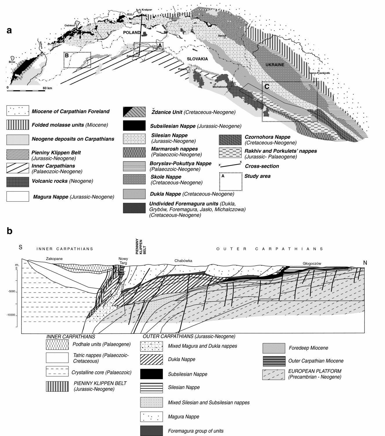
Figure 1. (a) Location of the Pieniny Klippen Belt within the Carpathians in Slovakia, Poland and Ukraine on the geological map and (b) Kraków–Zakopane cross-section. Modified from Lexa et al. (Reference Lexa, Bezák, Elečko, Mello, Polák, Potfaj and Vozár2000) and Ślączka et al. (Reference Ślączka, Kruglov, Golonka, Oszczypko, Popadyuk, Golonka and Picha2006).
The PKB forms a strongly tectonized feature some 600 km long, 1–20 km wide, stretching from Podbranc in Slovakia to northern Romania and marking the suture zone between the Inner Carpathian Terrane and the North European Platform. The term Pieniny Klippen Belt was first used by Neumayr (Reference Neumayr1871). The geographic part of this name indicates the mountain range in Poland and Slovakia where numerous klippes (klippen) built scenic rocks around the Dunajec River gorge. This gorge has been a prime geotourist attraction since the nineteenth century (Krobicki & Golonka, Reference Krobicki and Golonka2008b ). The klippen are relatively erosion-resistant blocks surrounded by and rising above the less-competent rocks (mainly flysch, shales and marls).
These blocks were traditionally considered as tectonic slivers. However, the role of olistoliths in the formation of the klippen belts has become better understood recently (e.g. Nemčok, Reference Nemčok1980; Cieszkowski et al. Reference Cieszkowski, Golonka, Krobicki, Ślączka, Oszczypko, Waśkowska and Wendorff2009). In modern literature (e.g. Krobicki & Golonka, Reference Krobicki and Golonka2008a ; Pieńkowski et al. Reference Pieńkowski, Schudack, Bosák, Enay, Feldman-Olszewska, Golonka, Gutowski, Herngreen, Jordan, Krobicki, Lathuiliere, Leinfelder, Michalík, Mönnig, Noe-Nygaard, Pálfy, Pint, Rasser, Reisdorf, Schmid, Schweigert, Surlyk, Wetzel, Wong and McCann2008; Schmid et al. Reference Schmid, Bernoulli, Fugenschuh, Matenco, Schefer, Schuster, Tischler and Ustaszewski2008), the present-day confines of the PKB are regarded as strictly tectonic and characterized as subvertical faults and shear zones. A strong reduction of space of the original sedimentary basins took place within the PKB. A Tertiary strike-slip boundary is located between the Inner Carpathians nappes and the PKB. The relationship between PKB and the Magura Nappe changes along the PKB strike. In the Vah and Orava valleys these two units are divided by the Miocene subvertical strike-slip fault, and both units form the complex flower structure. The tectonic character of the Polish section of PKB is mixed. Both strike-slip and thrust components occur here (e.g. Golonka & Rączkowski, Reference Golonka and Rączkowski1984; Jurewicz, Reference Jurewicz2005). In general, the subvertically arranged Jurassic – Lower Cretaceous basinal facies display the tectonics of the diapiric character originated in the strike-slip zone between two plates. The Upper Cretaceous – Palaeogene flysch sequences of the Złatne Basin (Golonka & Sikora, Reference Golonka and Sikora1981) are often thrust over the various slope and ridge sequences. Back-thrusts occur in the East Slovakian section of the PKB. The Magura Nappe is thrust over the PKB and the PKB over the Central Carpathian Palaeogene layer (see Nemčok, Reference Nemčok1980; Oszczypko et al. Reference Oszczypko, Oszczypko-Clowes, Golonka and Marko2005b ). In Ukraine, flysch sequences with a klippen component are thrust over the Marmarosh Klippen Nappe regarded recently as an eastern extension of the Magura Nappe (Oszczypko et al. Reference Oszczypko, Oszczypko-Clowes, Golonka and Krobicki2005a ). They are covered by Neogene deposits and volcanics of the Transcarpathian Depression.
The erosion-resistant blocks of PKB were deposited within the palaeogeographic realm known as the Alpine Tethys (Fig. 2), mainly during Jurassic – Early Cretaceous time. These deposits have traditionally been divided into several successions mainly based on differences in the development of deep- and shallow-water limestones, marls and radiolarites (Andrusov, Reference Andrusov1945; Birkenmajer, Reference Birkenmajer1977; Golonka & Krobicki, Reference Golonka and Krobicki2004). The ridge dividing the Alpine Tethys into two basins during Jurassic–Cretaceous time was a site of the Czorsztyn Succession with relatively shallow-water sedimentation (Birkenmajer, Reference Birkenmajer1963, Reference Birkenmajer1977; Wierzbowski, Jaworska & Krobicki, Reference Wierzbowski, Jaworska and Krobicki1999; Golonka & Krobicki, Reference Golonka and Krobicki2004). The deep-water Jurassic – Lower Cretaceous deposits (pelagic limestones and radiolarites) of the SE Alpine Tethys basin (Złatne Basin, Pieniny Basin or Vahicum, which is equivalent to Vahic; Birkenmajer, Reference Birkenmajer1977; Oszczypko, Salata & Krobicki, Reference Oszczypko, Salata and Krobicki2012; Plašienka, Reference Plašienka2012) belong to the Złatne Succession (Sikora, Reference Sikora1971; Golonka & Sikora, Reference Golonka and Sikora1981; Golonka & Krobicki, Reference Golonka and Krobicki2004). Similar deposits of the NW Alpine Tethys (Magura Basin; Golonka, Oszczypko & Ślączka, Reference Golonka, Oszczypko and Ślączka2000; Golonka & Krobicki, Reference Golonka and Krobicki2004; Golonka et al. Reference Golonka, Gahagan, Krobicki, Marko, Oszczypko, Ślączka, Golonka and Picha2006, Reference Golonka, Krobicki, Waśkowska-Oliwa, Vašíček, Skupien and Krobicki2008; Golonka, Reference Golonka, Bąk, Kaminski and Waśkowska2011) are known as Magura, Hulina or Grajcarek successions. Somewhat shallower sedimentary zones, known as the Pieniny, Branisko (Kysuca) and Zawiasy successions, were located close to the central furrows of both basins. Transitional slope sequences between basinal units and ridge units are known as the Czertezik and Niedzica successions (Orava and Pruské successions in Slovakia). The PKB also contains shallow-water sequences of the SW margin of the Alpine Tethys known as the Haligovce and Manin successions.
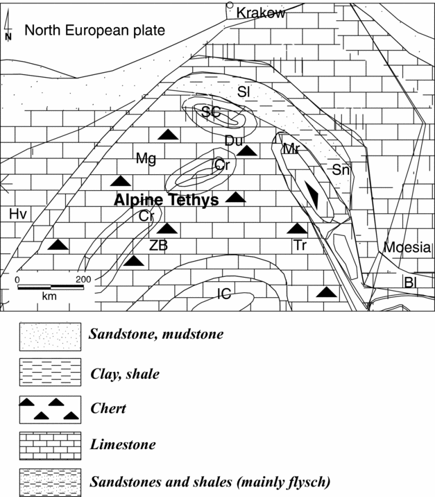
Figure 2. Position of the Alpine Tethys during Late Jurassic – Early Cretaceous time (modified from Golonka et al. Reference Golonka, Gahagan, Krobicki, Marko, Oszczypko, Ślączka, Golonka and Picha2006). Bl – Balkans; Cr – Czorsztyn Ridge; Du – Dukla Basin; Hv – Helvetic; IC – Inner Carpathians; Mg – Magura Basin; Mr – Marmarosh; SC – Silesian Ridge (cordillera); Sl – Silesian Basin; Sn – Sinaia Basin; Tr – Transylvanian; ZB – Złatne Basin.
As a result of the large number of these successions, authors often attempt to group them. Oszczypko, Jurewicz & Plašienka (Reference Oszczypko, Jurewicz and Plašienka2010) distinguished deeper-water sequences as belonging to Pieniny Nappe and shallower sequences as belonging to the Subpieniny Nappe (see also Plašienka, Reference Plašienka2012). This approach mixes together facies development and tectonics. However, with the extreme complexity of PKB, these features are often very hard to distinguish. The flysch sequences constitute the main component of PKB. Their sedimentation began during Albian time and lasted until Neogene time. The main bulk of these sequences are Late Cretaceous – Palaeogene in age.
3. Methods
From numerous olistostrome/olistolith bodies in the PKB, several areas of Slovakia (western and eastern sectors), Poland and Ukraine (Transcarpathian part) have been selected as containing the best exposed and most spectacular examples. All investigated bodies comprise Triassic–Cretaceous strata and have well-exposed contact with flysch/flyschoidal-type deposits, which surround them. Their dimensions vary from tens of metres to kilometres. Detailed fieldwork was conducted and supplemented by stratigraphic and sedimentologic studies, using microfacies analysis among other techniques. Teledetection techniques (geological interpretation of aerial photographs, satellite images, radar images, condensed contour maps and digital elevation models or DEMs) were also used. These techniques were supplemented by interpreting existing maps (1:10,000 scale), stratigraphic studies, sedimentologic studies and analysis of local tectonics. Detailed field mapping enabled the identification of localities with olistostromes and large olistoliths.
4. Results: olistostromes within the PKB
4.a. The central PKB
The olistostromes form two belts which are best visible in the central part of the PKB, which belongs to Poland, and an adjacent part of Slovakia. Figure 3, in which the olistoliths are not to scale, covers this sector. The concept of olistostromes and olistoliths, rather than their exact location, is what is depicted in Figure 3. Often the olistoliths are too small to appear in the sketch map, so they are grouped together. The maps and cross-sections of PKB are depicted in Figures 4–11.

Figure 3. Sketch map of the central part of the Pieniny Klippen Belt in Poland and Slovakia with diagrammatic (not to scale) position of olistoliths. Olistoliths mentioned in text: 1 – Haligovce; 2 – Homole; 3 – Litmanova; 4 – Kotuńka; 5 – Ścigocki Stream; 6 – Zawiasy; 7 – Łupisko; 8 – Czorsztyn; 9 – Rogoźnik; 10 – Stare Bystre. Modified from Golonka & Rączkowski (Reference Golonka and Rączkowski1984), Lexa et al. (Reference Lexa, Bezák, Elečko, Mello, Polák, Potfaj and Vozár2000), Chrustek et al. (Reference Chrustek, Golonka, Janeczko and Stachyrak2005) and Oszczypko et al. (Reference Oszczypko, Jurewicz and Plašienka2010).

Figure 4. Geological map of the Małe Pieniny area with the position of olistoliths and cross-sections through the Pieniny Klippen Belt. Modified from Golonka & Rączkowski (Reference Golonka and Rączkowski1984), Lexa et al. (Reference Lexa, Bezák, Elečko, Mello, Polák, Potfaj and Vozár2000) and Oszczypko et al. (Reference Oszczypko, Jurewicz and Plašienka2010).

Figure 5. General cross-sections through the Małe Pieniny area. I–I’ – Jaworki–Haligovce; II–II’ – Litmanova. Location in Figure 4.

Figure 6. Detailed cross-sections through the Homole Block (a) according to Birkenmajer (Reference Birkenmajer1970), simplified; and (b) according to present authors (see also Jurewicz, Reference Jurewicz1997; Cieszkowski et al. Reference Cieszkowski, Golonka, Krobicki, Ślączka, Oszczypko, Waśkowska and Wendorff2009; Oszczypko et al. Reference Oszczypko, Jurewicz and Plašienka2010).

Figure 7. Model of the deposition of olistolith during Late Cretaceous – Palaeogene time in the Złatne and Magura basins in Haligovce–Jaworki area in Małe Pieniny, Poland and Slovakia. C – Coral-algal reef; HB – Homole-Biała Woda olistolith; HG – Haligovce olistoliths; KH – Kambühel Limestone olistolith; LT – Litmanova olistoliths; ZS – Zawiasy olistolith.

Figure 8. Geological map and cross-section of the Považie area in Slovakia (modified from Mello, Reference Mello2005). IIII–III’ – cross-section through the Butkov-Michalova area.

Figure 9. Position of the Mariková Olistolith (modified from Plašienka et al. Reference Plašienka, Sýkora, Aubrecht, Krobicki and Józsa2010).
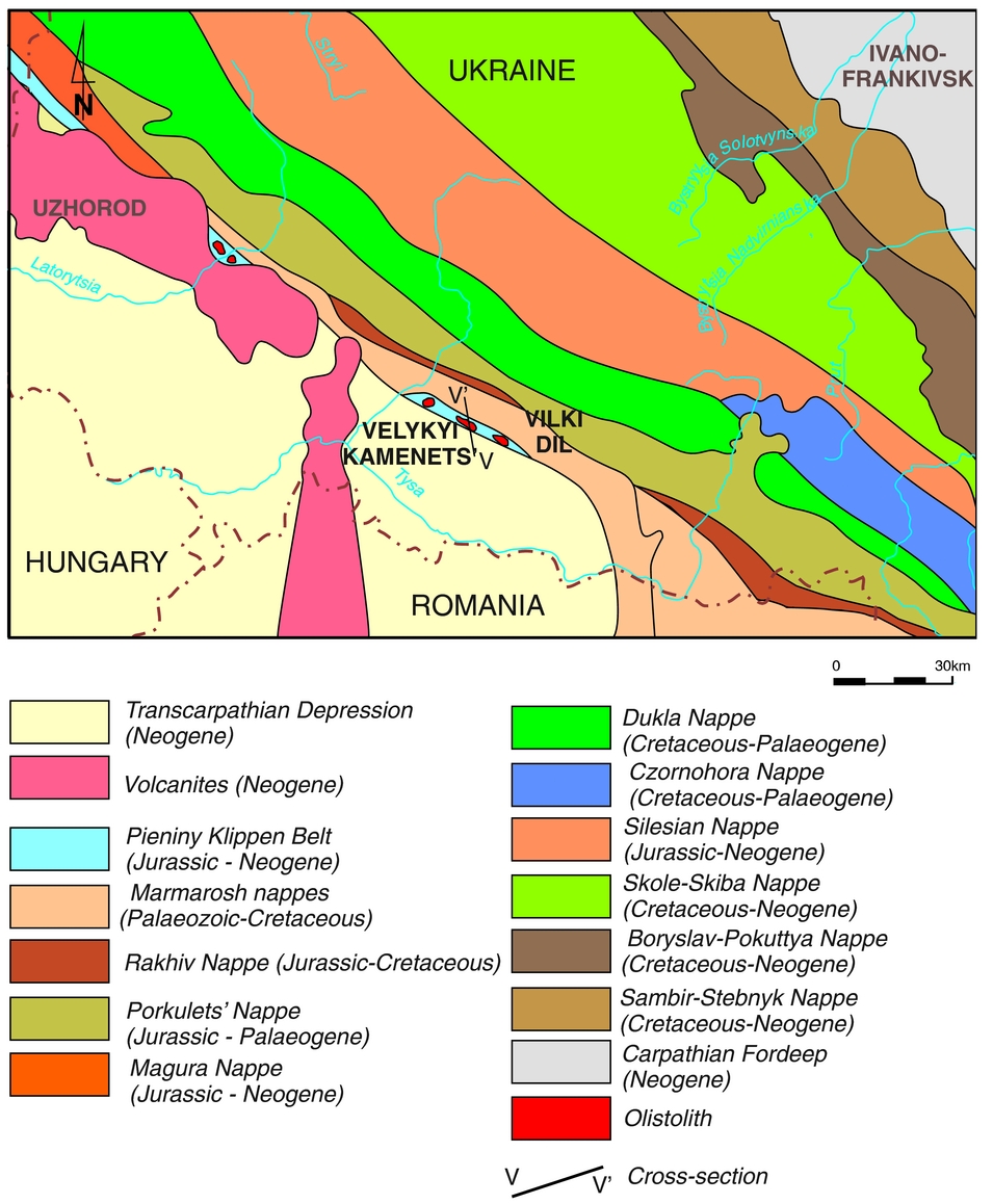
Figure 10. The Veliky Kamenets area in Ukraine with position of the Pieniny Klippen Belt and location of the cross-section V–V’. Modified from Ślączka et al. (Reference Ślączka, Kruglov, Golonka, Oszczypko, Popadyuk, Golonka and Picha2006).
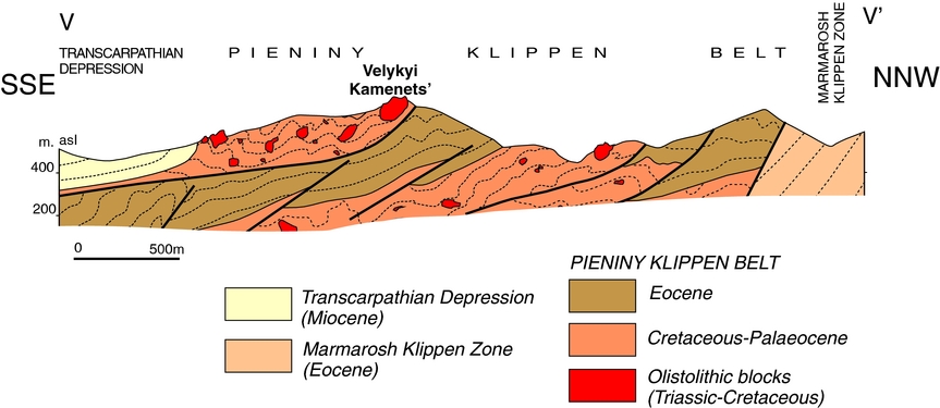
Figure 11. Cross-section V-V’ through the Veliky Kamenets area.
The first olistostrome belt was formed within the Cretaceous–Palaeogene flysch of the Złatne Basin. The Albian–Oligocene age of this flysch was determined on the basis of foraminifer assemblages (Golonka & Sikora, Reference Golonka and Sikora1981). The largest and best-exposed olistoliths are known from Slovakia, south of the Polish–Slovak border which runs along the Małe Pieniny Mountain range. The olistoliths size varies from 1 m to 2 km. Huge olistoliths (Figs 4–5, 12) belonging to this belt were found in the vicinity of the Haligovce village in eastern Slovakia (close to Červeny Klaštor near Dunajec River Gorge) in the Złatne Unit. Mesozoic rocks, of which the olistoliths are composed within this olistostrome belt, are represented by Triassic – Early Cretaceous carbonate/siliceous deposits. These belong to the Haligovce Succession (Birkenmajer, Reference Birkenmajer1959, Reference Birkenmajer1977), representing Inner-Carpathian-type formations.

Figure 12. Selected olistoliths and olistostromes within the Polish and Slovak Pieniny Klippen Belt. (a) Haligovce olistostrome; the hill klippe represents the Mesozoic sequences and the small klippe in front of the large hill klippe represents the Paleocene Kambühel type limestone. (b) Paleocene Kambühel-type limestone in the Haligovce olistostrome. (c) Corals in the Paleocene Kambühel-type limestone, village of Vélký Lipník near Haligovce. (d) Homole-Biała Woda olistolith; this huge limestone block in the Homole Gorge above the village of Jaworki is surrounded by flysch rocks of the Magura Basin, exposed in the small hill right of the village (Tatra Mountains of the Inner Carpathians in the background, 20 km south of Jaworki).
The Middle Triassic grey dolomitic limestones and dolomites are the oldest rocks of this succession, and Lower Jurassic rocks are represented by crinoidal and organogenic-oolithic limestones. The upper Liassic – lower Dogger sandy-crinoidal limestones with black cherts are main components of the Haligovce olistoliths. The younger rocks are Callovian–Oxfordian nodular limestones and radiolarites, Tithonian–Valanginian limestones with black cherts and Barremian–Aptian organogenic, organodetrical and rudist limestones of Urgonian type.
The Triassic – Early Cretaceous olistoliths are surrounded by Upper Cretaceous (Turonian–Maastrichtian) and Palaeogene flysch sequences of sandstones, shales, marls and conglomerates (Potfaj, Reference Potfaj2002). The conglomerates contain pebbles of granitoids, gneisses, quartz porphyrites, limestones and quartz. The Turonian flysch constitutes the matrix for the main bulk of the Haligovce olistoliths. The sedimentologic features of the Cretaceous and Palaeogene flysch indicate a NW direction of transport from the source area. During Paleocene time narrow carbonate platforms originated within this source area, which was full of coral-algal reefs in some places (Fig. 12) known as Kambühel-type limestones. Similar limestones were also found in Haligovce-Veľký Lipník area (Cieszkowski et al., Reference Cieszkowski, Golonka, Krobicki, Malata, Olszewska, Oszczypko, Tłuczek and Krobicki2004, Reference Cieszkowski, Golonka, Krobicki, Ślączka, Oszczypko, Waśkowska and Wendorff2009; Krobicki et al., Reference Krobicki, Golonka, Kołodziej, Olszewska, Oszczypko, Słomka, Tragelehn, Wieczorek and Krobicki2004, Reference Krobicki, Cieszkowski, Golonka, Kołodziej, Malata, Olszewska, Oszczypko, Tłuczek, Cieszkowski and Golonka2005b ), forming olistoliths within the Paleocene–Eocene flysch deposits of the Žilina Formation (Potfaj, Reference Potfaj2002; Cieszkowski et al. Reference Cieszkowski, Golonka, Krobicki, Ślączka, Oszczypko, Waśkowska and Wendorff2009). The huge Mesozoic Haligovce Klippen olistoliths and Paleocene limestone reefs blocks slid from the Złatne Basin margin to its slope and bottom during the formation of the Złatne flysch deposits in Paleocene–Eocene time (Fig. 7).
The second olistostrome belt (Figs 3–6) is related to the formation of submarine slumps and olistoliths along the southern margin of the Magura Basin (Fig. 7). The Jurassic – Early Cretaceous olistoliths are surrounded by Upper Cretaceous and Palaeogene flysch sequences built of sandstones, shales, marls and conglomerates (Chrustek et al. Reference Chrustek, Golonka, Janeczko and Stachyrak2005; Cieszkowski et al. Reference Cieszkowski, Golonka, Krobicki, Ślączka, Oszczypko, Waśkowska and Wendorff2009). The olistoliths vary in size from 1 m to 2 km.
The famous Homole Gorge (Fig. 5) cuts the Homole-Biała Woda block (Oszczypko, Jurewicz & Plašienka Reference Oszczypko, Jurewicz and Plašienka2010), which is one of the biggest and most spectacular olistoliths in the PKB (Cieszkowski et al. Reference Cieszkowski, Golonka, Krobicki, Ślączka, Oszczypko, Waśkowska and Wendorff2009). It is located close to the border between the Magura Nappe of the Outer Flysch Carpathians and the PKB in the vicinity of Jaworki village, in the Małe Pieniny area. In this gorge, an c.100 m thick section of the Bajocian crinoidal limestones of the Czorsztyn Succession (Birkenmajer, Reference Birkenmajer1963, Reference Birkenmajer1970, Reference Birkenmajer1977) is exposed, with overlying red nodular limestones of the Ammonitico Rosso-type facies (latest Bajocian – Tithonian in age; Wierzbowski, Jaworska & Krobicki, Reference Wierzbowski, Jaworska and Krobicki1999; Krobicki & Wierzbowski, Reference Krobicki and Wierzbowski2004; Fig. 6a) and Globotruncana-bearing marls of Cretaceous age.
The Niedzica Unit (southeast of Czorsztyn Succession in the Pieniny Basin; Golonka & Krobicki, Reference Golonka and Krobicki2004; Wierzbowski et al. Reference Wierzbowski, Aubrecht, Krobicki, Matyja and Schlögl2004) is located next to the thick Czorsztyn Unit (Birkenmajer, Reference Birkenmajer1970; Golonka & Krobicki, Reference Golonka and Krobicki2004) in the Czajakowa Skała Klippe in the upper part of the Homole Gorge. The process which formed the Czajakowa Klippe structure has been interpreted as slump mass movement during which the Niedzica Unit overrode the Czorsztyn Unit (Jurewicz, Reference Jurewicz1997, Reference Jurewicz2005). The Niedzica Unit consists of carbonate deposits of crinoidal limestones (Bajocian), red nodular limestones (Ammonitico Rosso facies of latest Bajocian–Tithonian age) and siliceous deposits of radiolarites which intercalated the Oxfordian nodular limestones. These deposits are covered by younger grey Maiolica-type limestones (Early Cretaceous) and Globotruncana-rich marls (Late Cretaceous; Birkenmajer, Reference Birkenmajer1977).
The Oxfordian radiolarites of the Niedzica Succession indicate deeper environments during their sedimentation than the Ammonitico Rosso limestones of the Czorsztyn Succession of the same age. These deposits were originally deposited on the SE slope of the submarine Czorsztyn Ridge (Krobicki, Golonka & Słomka, Reference Krobicki, Golonka and Słomka2010). The Biała Woda gorge is cut into Jurassic and Cretaceous rocks of the Czorsztyn Succession. Limestones originated in the pelagic environment of the PKB basin during Middle Jurassic and Early–Late Cretaceous time. They were deposited upon the Czorsztyn Ridge, that is, the shallowest zone, separating the PKB Basin from the Magura Basin situated further north (Golonka & Krobicki, Reference Golonka and Krobicki2004).
Mostly white crinoidal limestones of the Smolegowa Limestone Formation occur in the downstream part of the gorge (Bajocian in age; Krobicki & Wierzbowski, Reference Krobicki and Wierzbowski2004). The Smolegowa Skała Rock, from which the name of the formation is derived, marks the southern margin of the gorge. Crinoidal limestones are mostly massive and devoid of stratification. Their large thickness (exceeding 100 m) is responsible for the formation of such a spectacular gorge, within which these limestones are exposed both at the bottom and on the steep walls. Crinoids represent fossil remnants of skeletons of echinoderms dwelling at the Jurassic sea bottom. Crinoidal limestones of this type are widely known from the Alpine orogen. They mark a period of shallow-marine carbonate sedimentation during Middle Jurassic time. They are related to the profuse development of submarine crinoidal ‘meadows’ and their subsequent destruction, which led to the formation of crinoidal limestones of such a large thickness.
The Homole-Biała Woda Block (Figs 5, 6, 11, 13) can be found in Paleocene – early Eocene strata deposited within the Magura Basin (Chrustek et al. Reference Chrustek, Golonka, Janeczko and Stachyrak2005; Cieszkowski et al. Reference Cieszkowski, Golonka, Krobicki, Ślączka, Oszczypko, Waśkowska and Wendorff2009; Oszczypko, Jurewicz & Plašienka, Reference Oszczypko, Jurewicz and Plašienka2010). Figure 6b illustrates the huge olistolithic rigid block (olisthoplaka sensu Richter, Reference Richter1973; olistoplaques sensu Camerlenghi & Pini, Reference Camerlenghi and Pini2009; Cieszkowski et al. Reference Cieszkowski, Golonka, Krobicki, Ślączka, Oszczypko, Waśkowska and Wendorff2009, Reference Cieszkowski, Golonka, Ślączka and Waśkowska2012; Ślączka et al. Reference Ślączka, Renda, Cieszkowski, Golonka and Nigro2012) detached from the less-competent rocks of Magura Succession. The flower structure of PKB in this area (Fig. 5) makes the tectonic-olistostrome relationship even more complex. The 10 m long and 8 m wide basalt olistolith occurs within Maastrichtian–Paleocene flysch-type rocks with red shales of the Jarmuta Formation (Golonka & Rączkowski, Reference Golonka and Rączkowski1984; Birkenmajer & Lorenc, Reference Birkenmajer and Lorenc2008; Oszczypko, Salata & Krobicki, Reference Oszczypko, Salata and Krobicki2012). This is the olivine basalt, which includes feldspars, pyroxenes, biotite and amphiboles. Radiometric dating using K–Ar methods yielded ages of 120 Ma and 110 Ma for different varieties of this basalt (Birkenmajer & Pécskay, Reference Birkenmajer and Pécskay2000). According to Oszczypko, Salata & Krobicki (Reference Oszczypko, Salata and Krobicki2012), this basalt displays factors typical of ocean island alkali: intraplate basalts. The parent magma was probably derived from a HIMU reservoir type without crustal contamination.

Figure 13. Selected olistoliths and olistostromes within the Polish and Slovak Pieniny Klippen Belt: (a) Homole-Biała Woda olistolith, Biała Woda Gorge; (b) Litmanova olistolith; (c) Rogoźnik olistolith; and (d) Zawiasy olistolith.
In Litmanová village (eastern Slovakia, about 3 km WNW of Jarabina village and the junction of the main streams Vel’ký Lipnik and Rozdiel), the so-called Litmanovské Klippen (Fig. 12c) perfectly crop out. The full sequence of the Jurassic – Early Cretaceous deposits of the Czertezik Succession, which have been studied both lithologically and stratigraphically in detail by Wierzbowski et al. (Reference Wierzbowski, Aubrecht, Krobicki, Matyja and Schlögl2004), can also be seen here.
Nemčok (Reference Nemčok1980) has also studied olistoliths in the Litmanová–Jarabina area (see also Plašienka, Reference Plašienka2012). These olistoliths belong to the second olistostrome belt, formed within the Magura Basin (Figs 3–5). Their geological history is the same as the Homole-Biała Woda Block described above.
The Upper Cretaceous – Paleocene flysch sequences of the Magura Basin (mainly Jarmuta and Szczawnica formations) comprise the matrix of olistostromes. Several olistoliths belonging to the Magura Basin olistostrome belt are known from the central sector of the PKB, west of Szczawnica (Fig. 3). The olistoliths vary in size from 1 m to 300 m. Numerous small olistoliths such as Kotuńka, Ścigocki or Stare Bystre (Fig. 14a) represent different transitional successions deposited between the ridge and deeper transitional zone. Ścigocki olistolith, 3 m in size, represents an extremely sedimentary-thinned succession. The uppermost Jurassic – Lower Cretaceous Pieniny Limestone Formation (Maiolica-type limestones) of this olistolith is only 1 m thick (Golonka & Sikora, Reference Golonka and Sikora1981). These limestones comprise Nannoconus algae and radiolarians. The olistolith is surrounded by the Paleocene flysch deposits of the Szczawnica Formation.

Figure 14. Selected olistoliths and olistostromes within Polish and Ukrainian Pieniny Klippen Belt: (a) Stare Bystre olistolith; and (b) Veliky Kamenets olistolith in the upper part of the quarry.
Zawiasy (100 m in size; Fig.13d) and Łupisko (200 m in size) olistoliths belong to the so-called Branisko Succession. The Jurassic – Lower Cretaceous Pieniny Limestone Formation in these olistoliths indicates deposition on the NW slope of the Czorsztyn Ridge within a somewhat shallower environment than for Ścigocki olistolith. The famous Sobótka Klippe under the Czorsztyn Castle and Rogoźnik (Fig. 13c) olistoliths contains Czorsztyn Succession. They were deposited on the SE slope of the Czorsztyn Ridge. Large Zawiasy (Fig. 13d) and Łupisko olistoliths belong to the so-called Zawiasy Succession deposited on the northwestern slope of the Czorsztyn Ridge (Golonka & Krobicki, Reference Golonka and Krobicki2004). In many places such as the area SW of Nowy Targ in Poland (Fig. 3) or in Eastern Slovakia, the PKB is represented entirely by olistostrome belts representing Złatne and Magura parts of accretionary wedge with olistoliths in flysch sequences. At other locations, such as the Pieniny Mountains south, SE and SW of Szczawnica, olistostrome belts are represented by tectonically uplifted Jurassic–Cretaceous carbonate and siliceous rocks, representing mainly Pieniny Succession (Figs 4, 5).
4.b. The western PKB
The olistoliths in the western part of the PKB were first described by Salaj (Reference Salaj1991). Two parallel belts of olistolith-type rocks exist close to the towns of Považská Bystrica and Púchov in Slovakia (Fig. 8), either within several tectono-facies units of the PKB (SE belt) or within the Magura Nappe (NW belt). The Michalova olistolith belongs to the latter and is situated several kilometres from the northern boundary of the tectonically uplifted Jurassic – Lower Cretaceous carbonate and siliceous rocks, representing mainly the Czorsztyn and Kysuca successions.
A detailed description of the Mariková Klippen, which includes the Michalova olistolith, was published recently by Plašienka et al. (Reference Plašienka, Sýkora, Aubrecht, Krobicki and Józsa2010). The lithology, stratigraphy and presumably palaeogeographic position were analysed, and the present tectonic position of these klippen was suggested. The Triassic–Jurassic carbonate/siliceous rocks of the Michalova olistolith generally belong to the so-called Mariková Succession, which is surrounded by the Cretaceous–Palaeogene flysch deposits of the Magura Basin and by the Cretaceous flysch attributed by Plašienka et al. (Reference Plašienka, Sýkora, Aubrecht, Krobicki and Józsa2010) to Kysuca Succession (Fig. 9).
The position of the Michalova Klippe is an example of a huge olistolithic rigid block (olisthoplaka sensu Richter, Reference Richter1973; olistoplaques sensu Camerlenghi & Pini, Reference Camerlenghi and Pini2009; Cieszkowski et al. Reference Cieszkowski, Golonka, Krobicki, Ślączka, Oszczypko, Waśkowska and Wendorff2009, Reference Cieszkowski, Golonka, Ślączka and Waśkowska2012; Ślączka et al. Reference Ślączka, Renda, Cieszkowski, Golonka and Nigro2012) detaching from the less-competent rocks of the Magura Succession. It is too far away from the flower structure of PKB to represent the pure tectonic thrust-sheet. Based on the stratigraphical position of the youngest host rocks for this olistolith, within the Eocene siliciclastic flysch of the Zlin Formation of the Magura Basin (Plašienka et al. Reference Plašienka, Sýkora, Aubrecht, Krobicki and Józsa2010), we suggest that it originated during Eocene time. The origin of this olistolith was a Late Palaeogene gravitational sliding episode which destroyed the active accretionary prism of the folded PKB units (nappes). The exact position of the Cretaceous flysch in the Mariková area requires further investigation.
We cannot exclude the possibility that these rocks represent the older stratigraphic units within the Magura Basin. Numerous small olistoliths occur within this Kysuca flysch, Magura flysch and on the boundary between these two units. The SW olistostrome belt is represented by flysch of the Złatne Basin, assigned by Slovak authors (Mello, Reference Mello2005) to different tectonic units: the Manin, Klape and Kostelec (Fig. 8). These units contain small and large olistoliths within the Cretaceous–Palaeogene flysch matrix, varying in size from 1 m to 2 km. The occurrence of Paleocene reef limestones, similar to those in the Haligovce area, has also been noted within these units (Köhler, Salaj & Buček, Reference Köhler, Salaj and Buček1993). We believe that the mechanism of their emplacement within the PKB flysch units is similar to that presented in Figure 7. The exact position of some klippen in this area requires further investigation. The geological map of this area (Fig. 8) provides examples of ‘spots’ often in lithologic or/and stratigraphic contrast to their surroundings. The olistostromes contribute to the mosaic (spotty) facture of the geological maps (see Cieszkowski et al. Reference Cieszkowski, Golonka, Krobicki, Ślączka, Oszczypko, Waśkowska and Wendorff2009).
4.c. The eastern PKB
The olistoliths in the PKB of western Ukraine are common in the Veliky Kamenets area (Figs 10, 11). In their geological cross-section of the inner part of the Ukrainian Carpathians (Fig. 11), Ślączka et al. (Reference Ślączka, Kruglov, Golonka, Oszczypko, Popadyuk, Golonka and Picha2006) depicted the remarkably visible occurrence of several isolated klippen/blocks within both the Cretaceous and Palaeogene matrixes. The size of these blocks varies from 1 m to 1 km. We interpreted these blocks as the numerous olistoliths forming olistostromes imbricated from the SE to the NW. According to Ślączka et al. (Reference Ślączka, Kruglov, Golonka, Oszczypko, Popadyuk, Golonka and Picha2006), the Veliky Kamenets is one of the biggest olistoliths in this region. The Kamenets quarry (Fig. 14b) is located in the Transcarpathian Ukraine, near the village of Novoselica in the SW part of the Ukrainian sector of the PKB.
One of the most spectacular outcrops in this region can be found at the top of a hill which lies between the Vulkhovchik and Luzhanka rivers. This has previously been described by Andrusov (Reference Andrusov1945) and more recently by Krobicki et al. (Reference Krobicki, Kruglov, Matyja, Wierzbowski, Aubrecht, Bubniak and Bubniak2003, Reference Krobicki, Budzyń, Golonka, Kruglov, Malata, Michalik, Oszczypko, Skiba, Słaby, Słomka and Zych2005a , Reference Krobicki, Oszczypko, Salata and Golonka2008), Lewandowski et al. (Reference Lewandowski, Krobicki, Matyja and Wierzbowski2005), Oszczypko et al. (Reference Oszczypko, Oszczypko-Clowes, Golonka and Krobicki2005a ), Oszczypko, Salata & Krobicki (Reference Oszczypko, Salata and Krobicki2012) and Reháková et al. (Reference Reháková, Matyja, Wierzbowski, Schlögl, Krobicki and Barski2011) and also mentioned by Ślączka et al. (Reference Ślączka, Kruglov, Golonka, Oszczypko, Popadyuk, Golonka and Picha2006). It exposes c. 50 m of the Lower Jurassic (Hettangian?) Gresten-type clastics, through the Middle Jurassic crinoidal and red nodular limestones of the Ammonitico Rosso-type (Bajocian–Tithonian) to lowermost Cretaceous (Berriasian) Calpionella-bearing limestones. According to thin radiolarite intercalations within the middle part of the red nodular limestones, the Kamenets Succession could be correlated (in a palaeogeographic sense) with the transition facies zone between the Czorsztyn and Niedzica successions (Krobicki et al. Reference Krobicki, Kruglov, Matyja, Wierzbowski, Aubrecht, Bubniak and Bubniak2003; Lewandowski et al. Reference Lewandowski, Krobicki, Matyja and Wierzbowski2005; Oszczypko et al. Reference Oszczypko, Oszczypko-Clowes, Golonka and Krobicki2005a ). The basaltic pillow lavas lie in the Berriasian part of the section.
Some of the volcanic sequences display patterns similar to mid-ocean-ridge basalt (MORB; Lashkevitsch, Medvedev & Krupskiy, Reference Lashkevitsch, Medvedev and Krupskiy1995; Varitchev, Reference Varitchev1997). The subduction-related magmatism could be related to the large-ion lithophile element (LILE) behavior in some other sequences occurring in the Eastern Carpathians (Lashkevitsch, Medvedev & Krupskiy, Reference Lashkevitsch, Medvedev and Krupskiy1995; Varitchev, Reference Varitchev1997). The LILE behavior could be a result of the melting process induced within the mantle wedge above the subducted slab, metasomatized by fluids released from the slab. The process could be more intensive if acting jointly with hot spot activity (Golonka et al. Reference Golonka, Krobicki, Oszczypko, Ślączka, Słomka, McCann and Saintot2003; Krobicki et al. Reference Krobicki, Budzyń, Golonka, Kruglov, Malata, Michalik, Oszczypko, Skiba, Słaby, Słomka and Zych2005a, Reference Krobicki, Oszczypko, Salata and Golonka2008; Krobicki, Golonka & Słomka, Reference Krobicki, Golonka and Słomka2010; Oszczypko, Salata & Krobicki, Reference Oszczypko, Salata and Krobicki2012). According to Oszczypko, Salata & Krobicki (Reference Oszczypko, Salata and Krobicki2012) the Eastern Carpathians basalts display features similar to Biała Woda rocks, which belong to the intraplate ocean island alkali basalts, with parent magma probably derived from a HIMU reservoir type and without crustal contamination.
Many smaller olistoliths containing Jurassic – Lower Cretaceous Czorsztyn Succession rocks are exposed within the Palaeogene conglomerates and flysch siliciclastic deposits in the Vilki Dil area.
5. Discussion
The results of our research indicate the existence of two flysch belts with olistostromes within the PKB in Poland and Slovakia. The first belt was formed during Cretaceous time; the oldest flysch deposits are of Albian age. The olistoliths are exposed within the Upper Cretaceous and Palaeogene flysch sequences. The Upper Cretaceous sequences contain Triassic – Lower Cretaceous olistoliths built of sedimentary rocks, mainly carbonates. The Mesozoic palaeogeographic reconstruction (Fig. 2) indicates the existence of the realm known as the Alpine Tethys, closely related to the deposition of Jurassic–Cretaceous rocks of the PKB. The term Alpine Tethys was introduced after the application of plate tectonics in the Alpine realm (e.g. Hsü, Reference Hsü1975). It has been applied to the ocean-related basins, linked to the opening of Central Atlantic and located during the Jurassic-Cretaceous times between the North European plate and plates belonging now to the ALCAPA (Alpine, Inner Carpathian, and Pannonian terranes). This Alpine Tethys constitutes the extension of the Central Atlantic system and also includes the Ligurian and Penninic oceans, which contain Jurassic ophiolites (Hsü, Reference Hsü, Dott and Shave1974, Reference Hsü1975; Bill et al. Reference Bill, O’Dogherty, Guex, Baumgartner and Masson2001; Golonka et al. Reference Golonka, Gahagan, Krobicki, Marko, Oszczypko, Ślączka, Golonka and Picha2006; Schmid et al. Reference Schmid, Bernoulli, Fugenschuh, Matenco, Schefer, Schuster, Tischler and Ustaszewski2008).
The Outer Carpathian was restructured at the end of Turonian time. Several ridges were uplifted as a result of orogenic processes in the Inner Carpathians. These processes were coeval with regional uplift in the southern margin of continental Europe from the Carpathian and Alpine foreland to Spain. This inversion could be correlated with the development of the rift of Biscay Bay (Cieszkowski et al. Reference Cieszkowski, Golonka, Ślączka and Waśkowska2012). The uplift of the Inner Carpathians supplied the basins with huge amounts of coarse-clastic material. The lithostratigraphic character of olistoliths and the transportation direction of flysch surrounding them indicate that the olistoliths (blocks of size 1 m to 2 km) in the southern belt were derived from the sedimentary cover of the Inner Carpathian terrane and its slopes. The olistoliths slid down from the SE margin of the Alpine Tethys.
Plašienka (Reference Plašienka2012) argued that these olistoliths are good evidence of synorogenic events in the inner Alpine Tethys (Penninic) zone. It was there that he distinguished two thrust-related tectonic phases (Donovaly and Selec) connected to Inner Carpathians movements. These events mark an early stage of the development of the accretionary prism formed during Late Cretaceous time as a result of the subduction of the southern part of the Alpine Tethys. The fore-arc basin originated along this subduction zone, with synorogenic flysch deposits. The Cretaceous southern belt olistoliths represent type A, B and C, applying Pini (Reference Pini1999) terminology.
Huge olistoliths deposited within the Cretaceous–Palaeogene flysch of the Złatne Basin, presently located in the vicinity of the village of Haligovce (eastern Slovakia), provide good examples of the fore-arc olistostrome setting which is similar to present-day oceanic margins (Barber, Yjokrosapoetro & Charlton, Reference Barber, Yjokrosapoetro and Charlton1986; Balance, Reference Balance1991; Duperret et al. Reference Duperret, Bourgois, Lagabrielle and Suess1995; McAdoo, Pratson & Orange, Reference McAdoo, Pratson and Orange2000; Mosher et al. Reference Mosher, Shipp, Moscardelli, Chaytor, Baxter, Lee and Urgeles2010; Yamada et al. Reference Yamada, Kawamura, Ikehara, Ogawa, Urgeles, Mosher, Chaytor and Strasser2012). The second belt is related to the movement of the accretionary prism, which had overridden the Czorsztyn Ridge during Late Cretaceous – Paleocene time (Golonka et al. Reference Golonka, Cieszkowski, Waśkowska, Krobicki and Ślączka2010). This process supports the model ceated by Festa et al. (Reference Festa, Pini, Dilek and Codegone2010a, Reference Festa, Pini, Dilek, Codegone, Vezzani, Ghisetti, Lucente and Ogatab) which predicts mass-transport deposits at the wedge front, as well as the phenomenon of seamount overriding observed at the present-day margins (von Huene & Lallemand, Reference von Huene and Lallemand1990; Chanier & Ferrière, Reference Chanier and Ferrière1991; von Huene & Scholl, Reference von Huene and Scholl1991; Dominguez et al. Reference Dominguez, Lallemand, Malavieille and von Huene1998; von Huene, Raner & Watts, Reference von Huene, Raner and Watts2004; Yamamoto et al. Reference Yamamoto, Ogawa, Uchino, Muraoka and Chiba2007, Reference Yamamoto, Nidaira, Ohta and Ogawa2009). It also supports the model designed by Jurewicz (Reference Jurewicz2005) for the PKB collision of the wedge with the Czorsztyn Ridge. Plašienka (Reference Plašienka2012) dated this event as having occurred at the Maastrichtian–Paleocene boundary Jarmuta phase. The basalts in the olistoliths indicate seamount features in the oceanic crust setting. This seamount is perhaps associated with the Pantelleria hot spots (Golonka & Bocharova, Reference Golonka and Bocharova2000) located on, or in close proximity to, the Czorsztyn Ridge. Both the seamount and the ridge could easily be overridden by the accretionary prism (Fig. 7). Several smaller olistoliths were deposited within the Maastrichtian–Paleocene Jarmuta Formation.
Numerous examples of olistoliths of type A and B (Pini, Reference Pini1999) have been documented in Poland, eastern and western Slovakia and in Ukraine. Very large blocks could slide independently into the basins, with no easily distinguishable matrix (type C; Pini, Reference Pini1999). The matrix in the presented case is the flysch sequence or even entire sedimentary-tectonic unit. The large Homole block in the village of Jaworki represents the best example of a huge olistolithic rigid block which has detached from the less-competent folded-and-thrust units and glided to the Magura Basin olistolith. The Czajakowa Klippe fold structure is also a good example of slump mass movements (Jurewicz, Reference Jurewicz2005), in which the sloping Niedzica Unit has overridden the ridged Czorsztyn Unit as the same time as the origin of the Homole-Biała Woda olistolith.
These huge olistolithic blocks and olistoplaques are common in the Carpathian marginal zone within flysch-molasse deposits of different units (e.g. Cieszkowski et al. Reference Cieszkowski, Golonka, Krobicki, Ślączka, Oszczypko, Waśkowska and Wendorff2009, Reference Cieszkowski, Golonka, Ślączka and Waśkowska2012; Ślączka et al. Reference Ślączka, Renda, Cieszkowski, Golonka and Nigro2012). A similar approach has been applied to the PKB in this article, where the term ‘olistostrome belt’ has been used to describe a linear arrangement of olistoliths parallel to the main tectonic structures of the PKB. The Złatne Basin obtained piggy-back features during Palaeogene time. The coral-algal reefs of the Kambühel-type limestones were developed on narrow carbonate platforms. These limestones are known from Paleocene–Eocene flysch deposits of the Žilina Formation (southern olistostrome belt), and represent intra-basinal olistoliths (endolistostromes; Neuendorf, Mehl & Jackson, Reference Neuendorf, Mehl and Jackson2005) immersed in a matrix (mud, clay, sand or a mixture).
The next tectonic episode was related to a strong early–middle Miocene compression and strike-slip processes. This led to the deformation of previously created olistostrome belts formed within the Złatne and Magura basins in the suture zone between the Inner Carpathian – Alpine (Alcapa) terrane and the North European plate, resulting in the present-day arrangement of the PKB. Tectonic components of different age and type (strike-slip, thrust and toe-thrust) and olistostromes have recently become mixed together, giving the present-day sedimentary-tectonic mélange character of this belt in which individual units are hard to distinguish. This is a good example of a mélange which originated as sedimentary and was later tectonized.
6. Conclusions: geodynamic evolution of the PKB and formation of olistostromes
We characterize the flysch with blocks (olistoliths) as olistostrome and refer to the linear arrangement of the olistoliths as ‘olistostrome belt’. Two olistostrome belts parallel to the main tectonic structures were recognized within the PKB.
The first was formed in the fore-arc basin with synorogenic flysch deposits. The orogenic process within the Alpine Tethys began during the latest Jurassic – Cretaceous time. Subduction developed along the northern margin of the Inner Carpathian terranes and began to consume the basins. Cherty limestones gave way to marls and flysch deposits. The fore-arc basin, with accretionary prism, was formed between the uplifted part of the Inner Carpathians terrane and the subduction zone. The flysch of Złatne Succession was formed in this area. The elements of the Inner Carpathian sedimentary cover slumped down the slope as olistoliths within the Złatne Basin.
The accretionary prism reached the Czorsztyn Ridge during Late Cretaceous – Paleocene time. The second belt originated when the accretionary prism overrode this ridge. The PKB succession from slopes of the Złatne and Magura basins, as well as from the ridge, was detached, defragmented into slices and thrust over the southern slope of the Magura Basin, forming numerous debris flows, olistoliths and olistostromes (Fig. 7).
The next tectonic episode was related to a strong early–middle Miocene, when compression resulted in the deformation of the Mesozoic and Palaeogene deposits. The PKB was formed as sedimentary-tectonic mélange in the suture zone between the Inner Carpathian – Alpine (Alcapa) terrane and the North European plate. Part of the allochthonous Outer Carpathian units, perhaps as well as the fragments of the basement, were also located in this suture zone. The olistostromes formed within the Złatne and Magura basins were involved in this process and were arranged into the olistostrome belts along the strike of the PKB structure.
Acknowledgements
This research was financially supported by the Polish Ministry of Science and Higher Education grants NN307 249733 and 256139, as well as by AGH University of Science and Technology, Kraków grant no. 11.11.140.173.


