1. Introduction
The appearance of Oldowan sites by 2.6 Ma reflects an important adaptive shift in hominin evolution. Stone artefact manufacture coupled with large mammal butchery, novel food, lithic transport and discard behaviours led to some of the oldest accumulations of archaeological debris (Potts, Reference Potts1991; Plummer, Reference Plummer2004). Although Oldowan sites are known of from c. 2.6–1.7 Ma in East, South and North Africa and in Georgia (Plummer, Reference Plummer2004), our understanding of the behavioural complexes leading to site formation remains rudimentary at best. This is partly because very few sites include both sizable artefact samples and well-preserved archaeological fauna. Moreover, it is sometimes unclear to what degree the associated fossil and artefact assemblages reflect onsite hominin activities, the mixing of unrelated behavioural traces by geological processes, or palimpsests of activity traces from different taxa (e.g. hominins and carnivores) (Dominguez-Rodrigo, Reference Domınguez-Rodrigo, Hovers and Braun2009).
At c. 2.0 Ma, the site of Kanjera is particularly significant: its Oldowan lithic and zoo archaeological assemblages are among the oldest and most substantially known, and both record novel behaviours in an open habitat different from other, more wooded Oldowan sites (Table 1; Plummer et al. Reference Plummer, Bishop, Ditchfield and Hicks1999; Bishop et al. Reference Bishop, Plummer, Ferraro, Braun, Ditchfield, Hertel, Kingston, Hicks and Potts2006; Plummer & Bishop, Reference Plummer and Bishop2016). Hominins were repeatedly attracted to the site locale, and alluvial and colluvial deposition resulted in Oldowan artefact and fossil accumulations in a c. 3-m-thick sequence. In contrast to other Oldowan sites (e.g. FLK-Zinjanthropus, Olduvai Gorge) the Kanjera South assemblages document a suite of hominin behaviours that were not ephemeral, but persisted over time. Here we describe the geochronology and depositional context of the Oldowan site complex at Kanjera South, southwestern Kenya, focusing on the lithology and depositional history of the Kanjera South Member. In particular, new granulometric analyses have refined our previous understanding of the geological processes that formed Kanjera South, and document that this Oldowan locality provides a reasonably unaltered record of hominin behaviour.
Table 1. Numbers of excavated materials from Kanjera South, recovered predominantly from Excavation 1. After Ferraro et al. (Reference Ferraro, Plummer, Pobiner, Oliver, Bishop, Braun, Ditchfield, Seaman, Binetti, Seaman, Hertel and Potts2013, table 1).
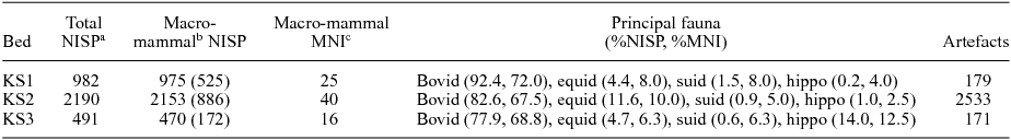
a Number of identified specimens collected with coordinate data. Thousands of non-identifiable bone fragments <2 cm are excluded from these counts, as are fossils from the conglomeratic facies (CP levels of Plummer et al. Reference Plummer, Bishop, Ditchfield and Hicks1999).
b Animals weighing more than 5 kg. Macro-mammal NISP values are total sums, followed by the sum of specimens identified beyond Linnean class in parentheses.
c Minimum number of individuals.
2. Physical setting
The early Pleistocene Oldowan occurrences at Kanjera South (0° 20′ 24″ S, 34° 32′ 16″ E) are found on the northern margins of the Homa Mountain Carbonatite Complex, Homa Peninsula, southwestern Kenya (Fig. 1) (Le Bas, Reference Le Bas1977). Homa Mountain is located on the southern shores of the Winam Gulf, a northeastern extension of Lake Victoria that lies in the fault-bounded Nyanza Rift system (Saggerson, Reference Saggerson1952). Volcanic activity associated with the mountain began with doming of the central portion of the edifice during late Miocene time and shifted to peripheral vents during Pliocene and Pleistocene time (Saggerson, Reference Saggerson1952; Le Bas, Reference Le Bas1977). Today, the heavily eroded edifice of Homa Mountain is 1754 m high, c. 600 m above the level of Lake Victoria. The mountain's lower slopes are incised by a radial drainage system exposing upper Miocene – Recent sediments (Kent, Reference Kent1942; Pickford, Reference Pickford1984; Ditchfield et al. Reference Ditchfield, Hicks, Plummer, Bishop and Potts1999). Evergreen forest and bushes cover portions of the upper slopes, undisturbed by human activity.
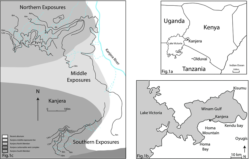
Figure 1. (a) Map of the Kanjera fossil localities on the Homa Peninsula, southwestern Kenya. (b) Location of Kanjera on the Homa Peninsula in the Winam Gulf, northeastern Lake Victoria. (c) Kanjera locality in detail with topographic contour lines at 2 m intervals from electronic distance measurement (EDM) survey. Dashed lines: modern drainage gullies; shading: major lithological units.
The history of palaeoanthropological research on the peninsula is summarized by Pickford (Reference Pickford1984), Behrensmeyer et al. (Reference Behrensmeyer, Potts, Plummer, Tauxe, Opdyke and Jorstad1995), Plummer & Potts (Reference Plummer and Potts1995) and Ditchfield et al. (Reference Ditchfield, Hicks, Plummer, Bishop and Potts1999). Fossiliferous deposits crop out at Kanjera in three areas, termed the Northern, Middle and Southern exposures (Fig. 1). Deposits in the Northern and Southern exposures were initially thought to be equivalent, although the stratigraphic framework was largely based on observations made in Kanjera North (Oswald, Reference Oswald1914; Kent, Reference Kent1942; Pickford, Reference Pickford1987). As more attention was paid to the stratigraphy of the Southern Exposures some differences in composition between the deposits in the north and south emerged, and separate bed definitions were devised for each area (Behrensmeyer et al. Reference Behrensmeyer, Potts, Plummer, Tauxe, Opdyke and Jorstad1995). Further work (Ditchfield et al. Reference Ditchfield, Hicks, Plummer, Bishop and Potts1999; Plummer et al. Reference Plummer, Bishop, Ditchfield and Hicks1999) indicated that no lithostratigraphic correlation existed between the north and south, and that the Southern Exposure sequence largely or entirely pre-dates deposition in the north. Deposits in the north and south were provisionally designated Kanjera Formation (N) and Kanjera Formation (S), respectively (Ditchfield et al. Reference Ditchfield, Hicks, Plummer, Bishop and Potts1999). The Kanjera North exposures consist of a series of low mounds of less than 3 m vertical relief, and include the type site of Theropithecus oswaldi and the discovery site of some controversial anatomically modern human fossils by L. S. B. Leakey (Leakey, Reference Leakey1935; Behrensmeyer et al. Reference Behrensmeyer, Potts, Plummer, Tauxe, Opdyke and Jorstad1995; Plummer & Potts, Reference Plummer and Potts1995). Magneto- and biostratigraphy suggest that deposition of the Kanjera Formation (N) began during middle – late early Pleistocene time and continued into middle Pleistocene time (Behrensmeyer et al. Reference Behrensmeyer, Potts, Plummer, Tauxe, Opdyke and Jorstad1995). Sediments were deposited at the margin of a small playa or lake, in fluvial, lake flat and lacustrine settings.
The Kanjera South deposits crop out c. 600 m south of the Kanjera North location in a small (50 000 m2), eastwards-facing amphitheatre, reaching c. 14 m above modern Lake Victoria (Behrensmeyer et al. Reference Behrensmeyer, Potts, Plummer, Tauxe, Opdyke and Jorstad1995).
3. Geological context of Oldowan occurrences
The Kanjera Formation is located on the northern flanks of the Homa Mountain massif. The country rocks of the Homa Peninsula consist of the Bukoben and Nyanzian metavolcanics and other high-grade metamorphic rocks (Saggerson, Reference Saggerson1952; Le Bas, Reference Le Bas1977). The emplacement of the Homa Mountain carbonatite system resulted in extensive fracturing and fenetization of these country rocks. The Plio-Pleistocene sediments are distributed radially around the Homa Mountain edifice, and unconformably overlie Miocene sediments of the Kanam Formation in some areas.
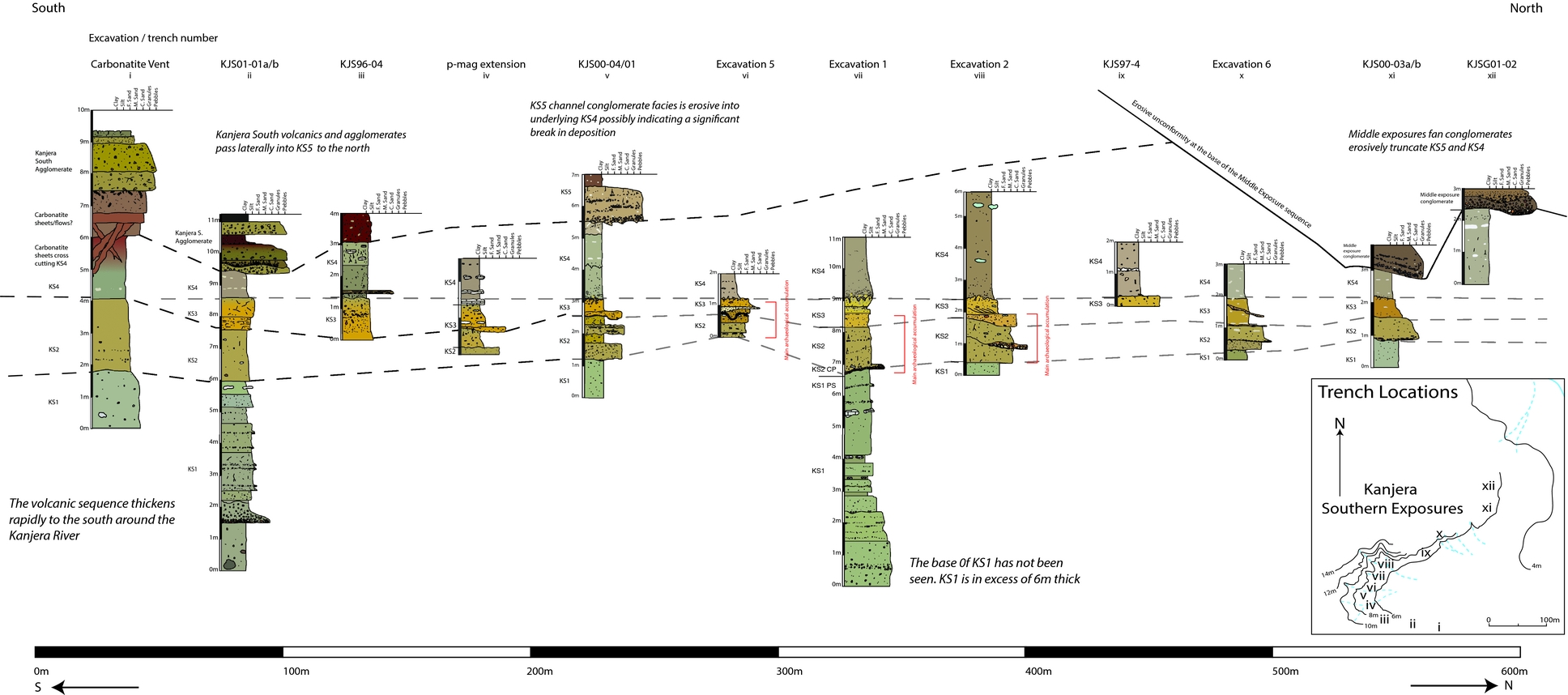
The Kanjera Formation is exposed regionally at Kanjera in the Northern, Middle and Southern exposures (Behrensmeyer et al. Reference Behrensmeyer, Potts, Plummer, Tauxe, Opdyke and Jorstad1995; Ditchfield et al. Reference Ditchfield, Hicks, Plummer, Bishop and Potts1999; Plummer et al. Reference Plummer, Bishop, Ditchfield and Hicks1999). The oldest units, beds KS1 to KS5, make up the Kanjera South Member and are exposed at the Kanjera South locality (Fig. 1). They have been the subject of extensive archaeological enquiry (Plummer et al. Reference Plummer, Bishop, Ditchfield and Hicks1999; Plummer, Reference Plummer2004; Ferraro, Reference Ferraro2007; Braun et al. Reference Braun, Plummer, Ditchfield, Ferraro, Maina, Bishop and Potts2008, Reference Braun, Plummer, Ferraro, Ditchfield and Bishop2009; Plummer et al. Reference Plummer, Ditchfield, Bishop, Kingston, Ferraro, Braun, Hertel and Potts2009; Ferraro et al. Reference Ferraro, Plummer, Pobiner, Oliver, Bishop, Braun, Ditchfield, Seaman, Binetti, Seaman, Hertel and Potts2013; Lemorini et al. Reference Lemorini, Plummer, Braun, Crittenden, Ditchfield, Bishop, Hertel, Oliver, Marlowe, Schoeninger and Potts2014; Plummer & Bishop, Reference Plummer and Bishop2016). These beds are dipping gently to the north and are affected, to a minor extent, by normal faults downstepping to the north and associated minor folding. The Kanjera South Member is overlain unconformably by the beds of Kanjera North Member (Beds KN1–5), which also dip northwards but are more intensively deformed by faulting associated with the Winam Gulf graben. These members were previously informally referred to as Kanjera Formation (S) and Kanjera Formation (N) (Plummer et al. Reference Plummer, Bishop, Ditchfield and Hicks1999). Both Kanjera South and Kanjera North members are unconformably overlain by the Kanjera Middle Exposure Member (KME1–3), which represents a west-to-east directed alluvial fan sequence erosive into both underlying members.
3.a. Kanjera bed descriptions and granulometric analysis
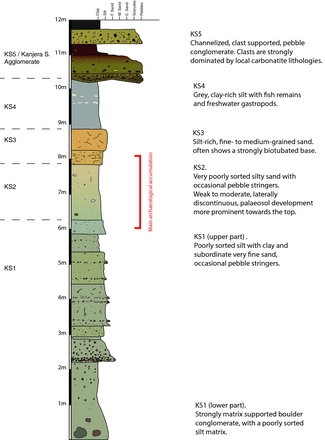
The lithological sequence of the Kanjera South Member consists of colluvially and, to a lesser extent, alluvially reworked pyroclastic deposits and lacustrine clays, capped by a local volcanic sequence related to a late, peripheral, parasitic vent from the Homa Mountain Volcanic Complex (Fig. 2). It has yielded archaeological occurrences from the top of bed KS1 through to the lower part of bed KS3.
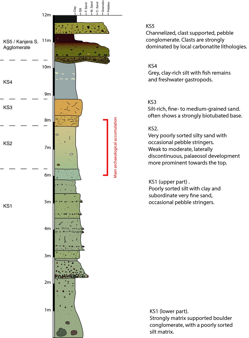
Figure 2. Composite log of the Kanjera South Member of the Kanjera Formation as seen in the excavations and geological trenches of the Kanjera South area. The member comprises five beds (KS1–5) with the conglomerates of KS5 interdigitating with agglomerates from a small, local, carbonatite vent to the south.
The base of the Kanjera South Member, bed KS1, is a thick, poorly bedded, pyroclastic deposit. This is at least 4 m thick and its base has not been reached in any of the excavations or geological trenches. The lowest visible part of this bed consists of very poorly sorted agglomerate with clast sizes ranging from granule to large boulders (in excess of 1 m diameter). These clasts are strongly matrix-supported in a fine sand to silt grade micaceous matrix, and clasts are largely sub-rounded, with a tendency for the smaller pebble- to granule-sized clasts to be more angular. The clast population is dominated by igneous rock types associated with the Homa Mountain volcanic complex. These range from coarse-grained ijolites to fine-grained carbonatites. The clast population also includes a significant proportion of fenetized, fine-grained, Nyanzian lavas and other pre-Cambrian basement lithologies. This lower part of KS1 shows little internal stratification, whereas the upper part is more regularly bedded. This upper part shows discrete beds up to 50 cm thick, often delineated by pebble to granule stringers at the base of the bed, which tend to be planar and weakly erosive into the underlying unit. These upper parts of bed KS1 show weak to moderate pedogenic alteration of the pyroclastic parent material with occasional in situ soil carbonates preserved.
The overlying bed, KS2, has a poorly defined base and is often gradational from the upper part of KS1. This bed is a moderately pedogenically altered and micaceous clay to gravel deposit dominated by silty sand. KS2 contains common granule- to pebble-grade clasts of local igneous rock frequently arranged as laterally discontinuous stringers, often only a single pebble or granule thick and typically extending laterally only a few centimetres. At several horizons in the upper part of KS2 there are thicker pebble conglomerates forming laterally discontinuous lenses. These conglomerates are matrix- to weakly clast-supported and dominated by pebble-sized clasts of local igneous rock types. Pebbles are sub-angular to sub-rounded and show no clear imbrication. The conglomerate lenses vary from 5 cm to 30 cm thick; they lack any real channelization and show only very weakly erosive bases or no evidence of erosive bases. Lenses occasionally show preferential carbonate cementation relative to the surrounding finer-grained material. The alluvial architecture of this unit comprises broad, shallow, weakly defined channels, or sheet flood-type structures (Blair, Reference Blair1999). Deposition via hyperconcentrated, tractional and mudflow processes are inferred. Palaeosol development occurs at several horizons within KS2, but is spatially discontinuous and shows only moderate to weak development.
Bed KS3 varies from a silt-rich, fine-grained sand to medium sand, with an often strongly bioturbated base. The bioturbation is frequently accompanied by preserved large mammal footprints and, along with other soft sediment deformation features, points to a wetter environment of deposition. KS3 also shows moderate- to well-developed palaeosols with in situ carbonate rhizoliths as well as other pedogenic carbonate nodules. At Excavation 2, towards the northern part of the Kanjera South exposures, a channel facies of KS3 is exposed. This displays clear cross-bedding with mean flow directions to the north in a moderately sized (at least 3 m width) asymmetric channel, the base of which is marked by a thin, discontinuous pebble lag marking an erosive surface into the underlying KS2.
Bed KS4 is a massively bedded grey to brown, plastic, poorly sorted clayey silt with occasional pedogenically altered horizons with weak carbonate nodule formation and root marks. It contains very few terrestrial fossils, but fish teeth, otoliths and freshwater gastropods are relatively common. No archaeological materials have been recovered from bed KS4.
Bed KS5 consists of beds of reddish-brown, poorly sorted silty clay showing signs of moderate pedogenesis, alternating with bands of clast-supported pebble conglomerates up to 30 cm thick. It has a gradational base and its top has not been observed at Kanjera South. The conglomerate beds become more restricted in the southern part of the outcrop within steep-sided channel features up to 1 m thick and 2.5 m wide. These channels are filled with a strongly matrix-supported, well-cemented, pebble conglomerate dominated by clasts, fine-grained carbonatite lavas and scoria. These channel features are laterally traceable to the south, where they are seen to pass into bedded agglomerates associated with a local carbonatite vent sequence (Fig. 3).

Figure 3. Kanjera South lithostratigraphy.
In the southern part of the Kanjera South exposures, the sedimentary sequence is overlain by pyroclastic deposits and minor carbonatite lavas from a local, late-stage, peripheral vent associated with the Homa Mountain volcanic complex. These include several feeder dykes to this vent. These dykes cross-cut the Kanjera South Formation (beds KS2–4) below the main outcrop of the volcanic sequence. The agglomerate beds associated with this vent interdigitate with the conglomerates of KS5 to the west of Excavation 1.
In the northern part of the Kanjera South exposures, the sequence is truncated by an erosive unconformity which is overlain by the conglomerates of the Middle Exposures Member. Figure 3 is a fence diagram showing representative logs of the above lithological units from geological trenches and archaeological excavations in the Kanjera South area.
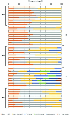
4. Granulometric analysis
Particle size analysis (PSA) is a well-established technique in reconstructing the transport processes, depositional mechanisms and depositional environments of sediments (Hassan, Reference Hassan1978; Friedman, Reference Friedman1979; Le Roux & Rojas, Reference Le Roux and Rojas2007; Clarke et al. Reference Clarke, Boyle, Chiverrell, Lario and Plater2014; Liu et al. Reference Liu, Qu, Ning, Gao, Zu and An2014; Amireh, Reference Amireh2015). Due to the ubiquitous nature of sediments, the application of PSA spans an array of environmental settings (Bement et al. Reference Bement, Carter, Varney, Cummings and Sudbury2007; Dill & Ludwig, Reference Dill and Ludwig2008; Dinakaran & Krishnayya, Reference Dinakaran and Krishnayya2011; de Haas et al. Reference de Haas, Ventra, Carbonneau and Kleinhans2014; Guan et al. Reference Guan, Zhu, Zhu, Wu and Li2016) and time periods (Gillies, Nickling & McTainsh, Reference Gillies, Nickling and McTainsh1996; Lekach et al. Reference Lekach, Amit, Grodek and Schick1998; Amit et al. Reference Amit, Lekach, Ayalon, Porat and Grodek2007; Houben, Reference Houben2007; Yin et al. Reference Yin, Liu, He, Zhao, Zhu, Wang, Liu and Wu2011; Schillereff et al. Reference Houben2016; Wang et al. Reference Wang, Li, Xu, Zheng and Huang2015). PSA has aided the current research by providing insights into the sedimentary environments and palaeohydrology at Kanjera South, allowing existing palaeoenvironmental reconstructions to be refined.
4.a. Methods
A total of 53 spot samples were acquired in excavations and geological trenches from beds KS1–5. Samples were subject to chemical pre-treatment (described by Konert & Vandenberghe, Reference Konert and Vandenberghe1997) to isolate discrete particles and provide evenly dispersed suspension (Liu et al. Reference Liu, Qu, Ning, Gao, Zu and An2014). Carbonates were not removed using hydrochloric acid, as these were suspected to make up a large proportion of the samples and be part of the original deposition. Analysis of samples was undertaken using laser diffraction, with each sample run five times to ensure reproducibility. Laser diffraction is limited to the analysis of the fine fraction (<2 mm); this fraction is discussed here. A detailed overview of the use of laser diffraction is given by Blott et al. (Reference Blott, Croft, Pye, Saye, Wilson, Pye and Croft2004). The software package GradiStat was used for particle size analysis, and to calculate textural parameters in phi units. A detailed overview of the package and its uses is provided by (Blott & Pye, Reference Blott and Pye2001).
4.b. Results
Particle size distributions are presented as size class divisions, due to the occurrence of polymodal sediments (Fig. 4); bed contacts are excluded from this representation. In KS1, samples are composed of clayey silts with subordinate very fine sands. They are characterized by a fine skew and poor/very poor sorting, with almost all of the sediment belonging to the suspension load (Visher, Reference Visher1969). In KS2 there is a coarsening of sediments to silty sands, which are noticeably more poorly sorted than adjacent beds. Samples are very poorly sorted and fine skewed with higher percentages of coarse sand, suggestive of a more significant saltation load during this period of deposition. Samples are also increasingly polymodal. KS3 shows a fining trend from KS2, with sediments consisting of silty sand and sandy silts more likely to have been transported through suspension. Poor to very poor sorting and a fine skew continue to define sediments in KS3. Sediments continue to follow a fining trend into KS4 with very poorly sorted and fine skewed clayey silts. The fine fraction of KS5 shows similar characteristics, with the exception of some samples that are composed of silty clays as well as clayey silts. Sediments remain poorly/very poorly sorted. With the reduction of coarser grain sizes in the fine-grained units of this bed, some samples lack any skew whereas some maintain a fine skew.
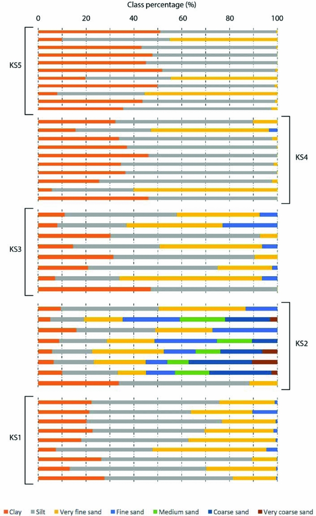
Figure 4. Particle size distributions for beds KS1–5 at Kanjera South. The majority of samples are dominated by silt and very fine sand, with the exception of those taken from KS2 that are much coarser. Stratigraphic sequencing within each bed is not implied here; samples were taken from laterally varying locations.
5. Environmental interpretation
The sedimentology and lithology of the Kanjera South Formation provide a record of the palaeoenvironments of its deposition. Previous interpretations of the Kanjera depositional environments are described in Table 2. The analysis presented below draws upon these previous studies and adds further field and laboratory analyses, including the previously discussed granulometric analysis of the matrix sediment (see Table 2 and Fig. 4).
Table 2. Summary of bed descriptions and environmental interpretations for the Kanjera South area based on observations in this study and previously published descriptions from Behrensmeyer et al. (Reference Behrensmeyer, Potts, Plummer, Tauxe, Opdyke and Jorstad1995), Ditchfield et al. (Reference Ditchfield, Hicks, Plummer, Bishop and Potts1999) and Plummer et al. (Reference Plummer, Ditchfield, Bishop, Kingston, Ferraro, Braun, Hertel and Potts2009).
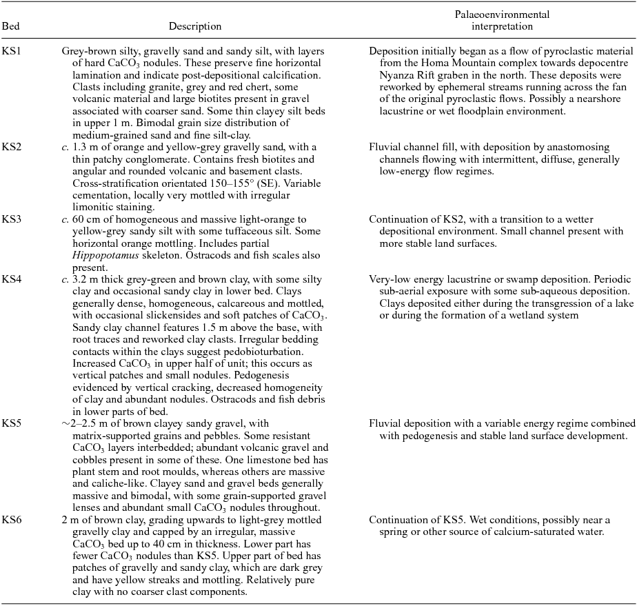
The lower part of KS1 possibly represents the deposits of one or more relatively large flows of remobilized pyroclastic material – most likely as lahars (volcanic debris flows) based on the abundance of clays and silts, as well as its very poor sorting and fine skew – in addition to the presence of large clasts and boulders of a wide variety of Homa Mountain igneous lithologies. These most probably moved from the Homa Mountain complex in the south towards a depositional centre in the north related to the Winam Gulf graben. These lower parts of KS1 show little internal stratification and no pedogenic development, and likely represent rapid deposition. The upper part of KS1, which lacks the coarse conglomerate component (boulder-grade material) and includes weak pedogenic development, represents intermittent reworking of the pyroclastic flow deposits, probably by ephemeral streams running across the landscape. KS2 further develops this latter style of deposition with more widespread and better-developed pedogenesis, indicating wider temporal spacing between depositional events. Unconfined channel structures (with weak erosive, weakly developed channel base structures), very poor sorting of the <2 mm fraction (poorly sorted grain size assemblages in the >2 mm fraction), multimodality and fine skew all indicate that deposition is likely to have been dominated by intermittent hyperconcentrated-to-mudflow events of an unconfined nature (Pierson, Reference Pierson2005). Such flow events would have been separated by periods of landscape stability with periods of pedogenic development, characteristic of alluvial fan and pediment/slope environments. This is important to the interpretation of archaeological remains deposited in KS2, as this style of deposition is less likely to erode the underlying surface, due to the relatively viscous nature and low shear stress bases (Pierson, Reference Pierson2005). This promotes preservation of surface archaeological accumulation, as surface objects are buried rather than eroded (de la Torre et al. Reference de la Torre, Albert, Macphail, McHenry, Pante, Rodríguez-Cintas, Stanistreet and Stollhofen2018; Stanistreet et al. Reference Stanistreet, Stollhofen, Njau, Farrugia, Pante, Masao, Albert and Bamford2018). In addition to this, flow hiatuses may have been characterized by aeolian deposition and reworking of sediment, which may have been subsequently reworked. Such reworking may account for the abundance of fine sediment, as well as the multimodal nature of grain size distributions (Vandenberghe, Derese & Kasse, Reference Vandenberghe, Derese and Kasse2013). Overall, the depositional environment of KS2 is compatible with an alluvial plain setting.
KS3 sees the transition to a wetter depositional environment reflected in the style of pedogenic alteration and preservation of soft sediment deformation features (especially large mammal pedoturbation), as well as the abundance of clays/silts and a very fine skew in the sediment. There is evidence of at least one channel in the area, as seen from the sequence at Excavation 2. This channel was at least 1 m deep and 3 m wide, and preserved the partial skeleton of a hippopotamid associated with artefacts. KS4 represents a continuation of this wetting trend as lake margin deposits transgressed from north to south over the area. Despite this, the lake system was at least periodically dry enough for minor palaeosol development to take place within at least two horizons in this unit.
Bed KS5 represents a return to terrestrial conditions following regression of the lake, possibly mediated by local uplift associated with the activity of the nearby Kanjera South volcanic vent system.
The lahar deposit that defines the lowermost known extent of KS1 would have been significant in the local area and perhaps beyond. Because the main unstratified body of the flow is at least 3 m thick, it likely destroyed all standing vegetation in its path and modified some aspects of local topography. The main archaeological horizon concentrated in KS2 and uppermost KS1 accumulated during the interval following the emplacement of the lahar deposits at the base of bed KS1, and before the lake margin transgression across the area at the base of bed KS4. Stable isotopic analysis of pedogenic carbonates from the archaeological strata at Kanjera South show a uniformly C4 grass-dominated signal that is further supported by the taxonomic and isotopic analyses of the numerous mammalian fossil remains recovered from the site (Plummer et al. Reference Plummer, Bishop, Ditchfield and Hicks1999, Reference Plummer, Ditchfield, Bishop, Kingston, Ferraro, Braun, Hertel and Potts2009). Kanjera South may therefore have been a particularly attractive locality for hominin activity during that time, with lake margin grassland on at least seasonally moist soils supporting an abundant local fauna, and ephemeral streams supporting patches of plants producing underground storage organs (Lemorini et al. Reference Lemorini, Plummer, Braun, Crittenden, Ditchfield, Bishop, Hertel, Oliver, Marlowe, Schoeninger and Potts2014).
6. Geochronology
A precise geochronology for the Kanjera South deposits is somewhat difficult to construct, partly due to the resistance to known dating techniques of the igneous material recovered so far. Repeated attempts to date overlying volcanics using Ar–Ar methods have been unsuccessful. However, a combination of palaeomagnetic and biostratigraphic studies using the abundant mammalian fauna allows us to delimit the age of the archaeological deposits. The proboscidean Deinotherium sp., the suids Metridiochoerus modestus and M. andrewsi, and the extant genus of equid Equus have all been recovered. The earliest African appearance of Equus dates to 2.3 Ma, as does the first appearance datum (FAD) for M. modestus (Cooke, Reference Cooke, Bobe, Alemseged and Behrensmeyer2007). M. andrewsi is known from the period 3.36–1.7 Ma elsewhere in Africa and Deinotherium sp. is known from deposits older than 1.5 Ma. These taxa indicate that archaeological materials were deposited during 2.3–1.7 Ma. Moreover, the Olduvai Subchron (1.922–1.775 Ma; Singer, Reference Singer2014) has been detected in the sediments of beds KS4 and KS5 (Ditchfield et al. Reference Ditchfield, Hicks, Plummer, Bishop and Potts1999). In Ditchfield et al. (Reference Ditchfield, Hicks, Plummer, Bishop and Potts1999, p. 141) the Olduvai Subchron was mistakenly identified as beginning in KS5, as the label for KS4 was missing from figure 8. This figure should have shown bed KS4 extending from just below palaeomagnetic sample KJS51 to c. 20 cm above palaeomagnetic sample KJS45. Normal polarity palaeomagnetic samples KJS45–56 are therefore from KS4, demonstrating that the Olduvai Subchron extended from KS4 across its contact with basal KS5. The underlying archaeological occurrences in beds KS1–3 must therefore pre-date the base of the Olduvai Subchron at 1.92 Ma, yielding a date of 2.3–1.92 Ma for hominin activity. Given the rapidity of deposition, it seems likely that the archaeological occurrences are closer to the younger end of this time interval, with an age of c. 2 Ma.
7. Analysis of site formation
In any discussion of archaeological site formation, the central question to be addressed is the extent to which artefacts and fossils are in primary depositional context. The answer to this question determines the types of behavioural inferences that can be drawn from study of the archaeological material. At Kanjera South, it is impossible to determine whether the sedimentary matrices were deposited primarily by alluvial and/or colluvial action given the lack of sedimentary structures in uppermost KS2. Field sedimentological observations, coupled with granulometric analyses of the matrix, indicate that the most likely environment of formation for KS2 is an alluvial fan/pediment. Deposition is characterized by hyperconcentrated (Pierson, Reference Pierson2005; de la Torre et al. Reference de la Torre, Albert, Macphail, McHenry, Pante, Rodríguez-Cintas, Stanistreet and Stollhofen2018) and tractional, unconfined flow events (Blair, Reference Blair1999). Given the fine-grained nature, fine skew and multimodality, it is possible that sediments were partly deposited via aeolian processes (Vandenberghe, Derese & Kasse, Reference Vandenberghe, Derese and Kasse2013). Sedimentary structures are absent partly due to in situ breakdown of volcanic materials from the Homa Mountain complex, which are altering into clays. Where bedding structures are present and not obliterated by subsequent pedogenesis, they lack significant channelization and therefore tend to point more towards unconfined sheet flow-like processes. The planar to undulating, unchannelized nature of pebbly lags at the base of some beds also supports this interpretation. Within the archaeological strata, most of the artefacts and bones are outsized clasts compared with the enclosing sediment (Plummer et al. Reference Plummer, Bishop, Ditchfield and Hicks1999). The general low-energy/fine-grained nature of the facies, coupled with evidence of mudflow to hyperconcentrated flows (notwithstanding minor conglomeratic lenses in KS2), indicates that depositional processes buried an in situ accumulation of artefacts and fossils. The general state of the archaeological materials, which show little weathering or rounding, preserve good surface and edge detail, and include bones with a range of hydraulic potentials, strongly supports this interpretation (Plummer et al. Reference Plummer, Bishop, Ditchfield and Hicks1999; Ferraro et al. Reference Ferraro, Plummer, Pobiner, Oliver, Bishop, Braun, Ditchfield, Seaman, Binetti, Seaman, Hertel and Potts2013; Lemorini et al. Reference Lemorini, Plummer, Braun, Crittenden, Ditchfield, Bishop, Hertel, Oliver, Marlowe, Schoeninger and Potts2014). Finally, the presence of thousands of non-identifiable bone fragments less than 2 cm in length (Ferraro, Reference Ferraro2007), which would likely have been winnowed away under a high-energy flow regime, also argues against the bone and artefact assemblages being formed through hydraulic activity. That these small fragments were not transported from elsewhere is indicated by their frequent association with larger bones bearing evidence of hammerstone percussion. Given the above, and taking into account the vertical distribution of materials, deposit depths and estimated rates of sedimentation, deposition likely occurred over a period of decades to centuries per bed, burying stone tools and faunal remains at or very near their place of discard.
8. Conclusions
In summary, this paper presents the geological setting and lithostratigraphic descriptions of the herein designated Kanjera South Member of the Kanjera Formation. Archaeological traces of Oldowan hominin behaviour have been recovered primarily from the upper part of bed KS1 through to the lower part of bed KS3, with a significant concentration in unit KS2. Analysis of the sedimentary facies sequence and stable isotopic analysis of pedogenic carbonates within the archaeological sequence point to a grass-dominated relatively low-slope environment, which formed relatively rapidly on top of earlier lahar deposits. There is a wetting trend from KS1 to KS4, possibly indicating that the lake margin was moving progressively closer through time. Traces of hominin activity in the area cease as lake facies transgressed from north to south across the site as seen in bed KS4. Although there are weak soil horizons within the lake deposits in KS4, indicating at least periodic retreat of the lake, these have yielded no archaeological materials. Granulometric analyses of the sediments indicate a sedimentary regime of hyperconcentrated flows with subordinate mudflows, which would not have significantly eroded or altered the surface on which they were deposited (Pierson, Reference Pierson2005; de la Torre et al. Reference de la Torre, Albert, Macphail, McHenry, Pante, Rodríguez-Cintas, Stanistreet and Stollhofen2018). It is notable that a similar depositional environment was recognized in Bed I Olduvai Gorge, Tanzania where this interpretation has also been applied (Stanistreet, Reference Stanistreet2012). The sedimentology and site formation processes of the archaeological strata at Kanjera South support the interpretation that the Oldowan assemblages represent a primary context accumulation from which behavioural inferences can be drawn reliably.
Acknowledgements
We are grateful to the Office of the President of Kenya and the National Museums of Kenya for permission to study the Kanjera fossils and artefacts. The Homa Peninsula field research was conducted through the cooperative agreement between the National Museums of Kenya and the Smithsonian Institution. Logistical support and funding was also provided by the Smithsonian's Human Origins Program. Funding from the Leakey Foundation, the National Geographic Society, the National Science Foundation, the Wenner–Gren Foundation and the Professional Staff Congress–City University of New York Research Award Program to TP for Kanjera field and laboratory work is gratefully acknowledged. We would like to thank Rick Potts and the Human Origins Program for support during all phases of the Kanjera research, and Joseph Ferraro for assistance in field directing the Kanjera excavations.
Supplementary material
To view supplementary material for this article, please visit https://doi.org/10.1017/S0016756818000602