1. Introduction
The Cenozoic structural and tectonic evolution of the western section of the Turkish Black Sea coast (Fig. 1) has attracted relatively little attention while a considerable amount of data have been published on the stratigraphic subdivision and the palaeogeography of the region (e.g. Erentöz & Ternek, Reference Erentöz and Ternek1959; Sönmez-Gökçen, Reference Sönmez-Gökçen1964; Nakoman, Reference Nakoman1968; Doust & Arıkan, Reference Doust and Arıkan1974; Keskin, Reference Keskin1974; Sîrel & Gündüz, Reference Sîrel and Gündüz1976; Görür et al. Reference Görür, Akkök, Seymen, Alkaya and Oktay1981; Alişan & Gerhard, Reference Alişan and Gerhard1987; Ercan, Yağmurlu & Uz, Reference Ercan, Yağmurlu and Uz1988; Sayar, Reference Sayar1989; Perinçek, Reference Perinçek1991; Turgut, Türkarslan & Perinçek, Reference Turgut, Türkarslan and Perinçek1991; Oktay, Eren & Sakınç, Reference Oktay, Eren and Sakınç1992; Sakınç, Reference Sakınç1994; İslamoğlu & Taner, Reference İslamoğlu and Taner1995; Sonel & Büyükutku, Reference Sonel and Büyükutku1998; Sakınç, Yaltırak & Oktay, Reference Sakınç, Yaltırak and Oktay1999; Turgut & Eseller, Reference Turgut and Eseller2000; Siyako & Huvaz, Reference Siyako and Huvaz2007). This region is considered to be a part of a former shallow (north) to deep (south) sea (Turgut, Türkarslan & Perinçek, Reference Turgut, Türkarslan and Perinçek1991; Görür & Okay, Reference Görür and Okay1996) developed just after the closure of the Intra-Pontide ocean (Şengör & Yılmaz, Reference Şengör and Yılmaz1981), which was the last significant tectonic event in the Western Pontides before the establishment of a wide Eocene carbonate platform (Perinçek, Reference Perinçek1991). Yet, opinions on the age of the Intra-Pontide suture vary considerably. It has been suggested to be Carboniferous (Okay et al. Reference Okay, Bozkurt, Satır, Yiğitbaş, Crowley and Shang2008), pre-Middle Jurassic (Okay, Reference Okay and Şengör1989), Late Jurassic – Early Cretaceous (Okay, Satır & Siebel, Reference Okay, Satır and Siebel2006), Early Cretaceous (Akbayram, Okay & Satır, Reference Akbayram, Okay and Satır2013), early Late Cretaceous (Okay et al. Reference Okay, Tüysüz, Satır, Özkan-Altiner, Altiner, Sherlock and Eren2006), Late Cretaceous (Yılmaz et al. Reference Yılmaz, Tüysüz, Yiğitbaş, Genç, Şengör and Robinson1997; Robertson & Ustaömer, Reference Robertson and Ustaömer2004), Cenomanian (Okay, Tansel & Tüysüz, Reference Okay, Tansel and Tüysüz2001), pre-Santonian (Özcan et al. Reference Özcan, Okay, Özcan, Hakyemez and Altiner2012), Early Eocene (Okay, Şengör & Görür, Reference Okay, Şengör and Görür1994; Görür & Okay, Reference Görür and Okay1996; Okay & Tüysüz, Reference Okay, Tüysüz, Durand, Jolivet, Horvath and Seranne1999; Okay, Reference Okay, Bozkurt, Winchester and Piper2000), between Paleocene and Lutetian (Şengör & Yılmaz, Reference Şengör and Yılmaz1981; Cavazza et al. Reference Cavazza, Federici, Okay and Zattin2012), or Early Ypresian (Cuisian) (Baykal & Önalan, Reference Baykal and Önalan1979) in age. Regardless of opinions on the timing of the Intra-Pontide ocean closure, all researchers now agree that since Middle Eocene time the region has been covered by a southerly deepening sea evolving in a rather quiet environment. Nevertheless, according to all palaeotectonic reconstructions this region belonged to the upper plate (Şengör & Yılmaz, Reference Şengör and Yılmaz1981), which includes the S-facing Late Cretaceous magmatic arc, and should be elevated after the Paleocene collision. The West Black Sea Fault bounding this arc in the west (Okay, Şengör & Görür, Reference Okay, Şengör and Görür1994; Fig. 1) is another problematic issue of the Intra-Pontide suture collision model. This plate is unconformably covered by Middle Eocene carbonates that are underlain by thin (2–300m) clastic sediments (Çağlayan & Yurtsever, Reference Çağlayan and Yurtsever1998) only in limited locations.

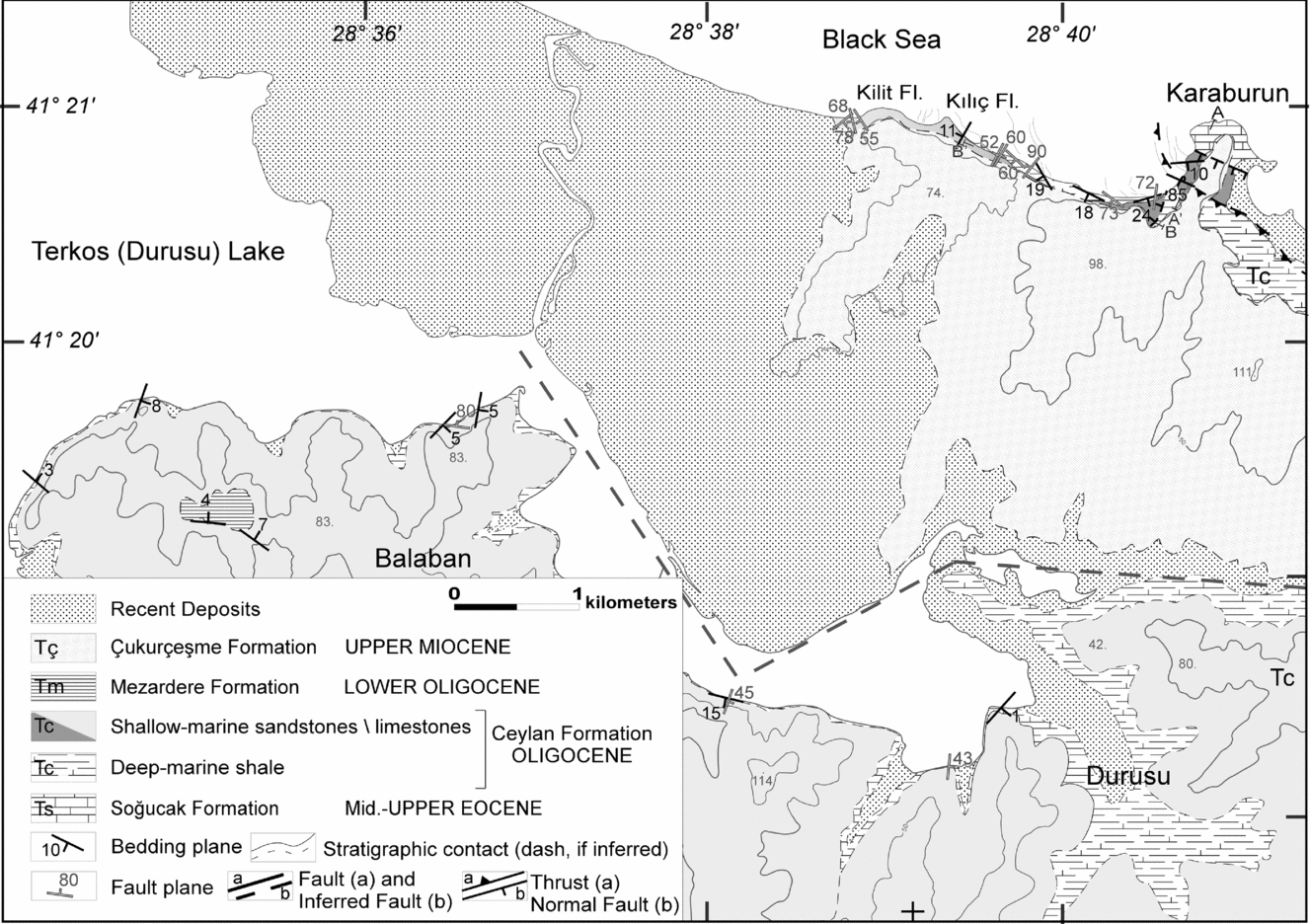
Figure 1. Main tectonic domains of NW Turkey: Thrace Basin (light grey), Strandja Massif (dark grey) and İstanbul Zone (grey). Heavy short dashed lines show the approximate position of the West Black Sea Fault. Heavy long dashed lines indicate Late Miocene fault systems (Perinçek, Reference Perinçek1991). The straight solid line is the Çatalca Fault (Karcıoğlu et al. Reference Karcıoğlu, Tank, Gürer, Çiftçi, Kaya and Tunçer2013). The box outlines the position of the studied region, the geological map of which is presented in Figure 2.
Opinions on the Eocene–Miocene tectonic history of the region also vary. The most complicated history is reconstructed for the western part of the Marmara Sea (Görür & Okay, Reference Görür and Okay1996; Siyako & Huvaz, Reference Siyako and Huvaz2007). The evolution of the eastern and northern parts of the Thrace Basin and its northern periphery are much simpler. According to Turgut, Türkarslan & Perinçek (Reference Turgut, Türkarslan and Perinçek1991) and Turgut & Eseller (Reference Turgut and Eseller2000), NW-trending normal faulting in the Thrace Basin was active in Middle Eocene time. A similar timing for this event is supported by Yılmaz & Polat (Reference Yılmaz and Polat1998), but they inferred a sinistral transpressional setting for these faults. Turgut, Türkarslan & Perinçek (Reference Turgut, Türkarslan and Perinçek1991) and Yılmaz & Polat (Reference Yılmaz and Polat1998) reported an Oligocene decrease in fault activity. All authors consider the Miocene to be the time of the main deformation event in the region (Şengör & Yılmaz, Reference Şengör and Yılmaz1981; Perinçek, Reference Perinçek1991; Turgut, Türkarslan & Perinçek, Reference Turgut, Türkarslan and Perinçek1991; Coşkun, Reference Coşkun1997; Sakınç, Yaltırak & Oktay, Reference Sakınç, Yaltırak and Oktay1999; Turgut & Eseller, Reference Turgut and Eseller2000) during which a complex system of transtensional and transpressional faults was formed.
A separation between the Mediterranean Tethys and Paratethys occurred in Oligocene time (Rögl, Reference Rögl1998; Steininger & Wessely, Reference Steininger and Wessely2000). In the Black Sea/Caspian regions it was related to the crustal shortening between the Pontides and Caucasus and the formation of a foredeep basin, in which the Maykop shales, the main source of petroleum resources (e.g. Ulmishek, Reference Ulmishek2001), were deposited. In the studied area, the transition of the Eocene carbonates to the Lower Oligocene siliciclastic sediments is usually interpreted as a transgression on the uplift existing between the Black Sea and Thrace Basin (Oktay et al. Reference Oktay, Eren and Sakınç1992; Sakınç, Yaltırak & Oktay, Reference Sakınç, Yaltırak and Oktay1999; İslamoğlu et al. Reference İslamoğlu, Harzhauser, Gross, Jiménez-Moreno, Coric, Kroh, Rögl and van der Made2010).
Stratigraphic and structural relationships recorded in the rocks exposed in the Karaburun/Durusu area (Fig. 1) provide important information on the Eocene–Oligocene palaeogeography and tectonic evolution of the western part of the Turkish Black Sea coast where the Lover Oligocene rocks have very limited exposures and are not known to the east of the Bosporus.
For the first time, we have documented two distinct phases of deformation that started with the extensional collapse of the Eocene carbonate platform and its Early Oligocene rapid subsidence, followed by an episode of compression and deposition of a shallowing-upward succession. We also found evidence for large-scale submarine gravitational sliding accompanying the compressional phase. Our discoveries also shed light on some unresolved problems of the tectonic evolution of neighbouring regions.
2. Geological setting
The studied region is located in the Western Pontides or central part of the Rhodope–Pontides fragment (Şengör & Yılmaz, Reference Şengör and Yılmaz1981) near the junction of three main structural domains: the Istanbul Zone, Strandja Massif and Thrace Basin (Fig. 1). The Istanbul Zone evolved until Late Carboniferous time as a possibly S-facing passive continental margin (Şengör & Yılmaz, Reference Şengör and Yılmaz1981) and the Strandja Massif evolved as a Palaeozoic–Triassic S-facing magmatic arc (Natal’in et al. 2012); the two are separated by the N–S-striking West Black Sea Fault (Okay, Şengör & Görür, Reference Okay, Şengör and Görür1994). It is inferred that this fault originated because of opening of the West Black Sea Basin and Late Cretaceous southward migration of the Istanbul Zone. However, the prominent gravity and magnetic anomalies formed by the Late Cretaceous Pontide magmatic arc (Ates, Kayıran & Sincer, Reference Ates, Kayıran and Sincer2003; Arslan, Akin & Alaca, Reference Arslan, Akin and Alaca2010) are not displaced and, therefore, the nature of the fault is problematic. The Intra-Pontide suture is not shown in Figure 1 because of complexities in the determination of its position (e.g. Okay & Tüysüz, Reference Okay, Tüysüz, Durand, Jolivet, Horvath and Seranne1999 v. Yılmaz et al. Reference Yılmaz, Tüysüz, Yiğitbaş, Genç, Şengör and Robinson1997).
During Eocene–Oligocene times, the southern and the southwestern parts of the Thrace Basin evolved in a deeper marine environment while the shallow shelf area was located in the north (Perinçek, Reference Perinçek1991; Turgut, Türkarslan & Perinçek, Reference Turgut, Türkarslan and Perinçek1991; Turgut & Eseller, Reference Turgut and Eseller2000). Eocene–Oligocene calc-alkalic volcanic rocks related to the formation of the Intra-Pontide suture and its eventual closure form a NW-striking belt along the southern side of the Thrace Basin (Yılmaz & Polat, Reference Yılmaz and Polat1998) but they have also been reported in the northern areas including the shelf zone (Oktay, Eren & Sakınç, Reference Oktay, Eren and Sakınç1992; Yurtsever & Çağlayan, Reference Yurtsever and Çağlayan2002). Late Miocene–Quaternary basanites and alkali olivine basalts show a similar distribution.
Miocene faults in the Thrace Basin form several NW-striking zones (Fig. 1). These faults have complicated kinematic features but almost all of them reveal a dextral sense of motion (Perinçek, Reference Perinçek1991; Turgut, Türkarslan & Perinçek, Reference Turgut, Türkarslan and Perinçek1991; Coşkun, Reference Coşkun1997). The northernmost fault zone (Turgut, Türkarslan & Perinçek, Reference Turgut, Türkarslan and Perinçek1991) evolved mainly because of transtension, while zones to the south show transpressional features. All these faults are sealed by Pliocene–Quaternary fluvial deposits (Turgut & Eseller, Reference Turgut and Eseller2000). The large fault zone closest to the studied area, the Çatalca Fault (Karcıoğlu et al. Reference Karcıoğlu, Tank, Gürer, Çiftçi, Kaya and Tunçer2013) (Fig. 1), perhaps follows the alleged West Black Sea Fault, and it dips to the southwest according to magnetotelluric data. Turgut & Eseller (Reference Turgut and Eseller2000) inferred a Miocene age for this fault, and geological maps (Çağlayan & Yurtsever, Reference Çağlayan and Yurtsever1998; Yurtsever & Çağlayan, Reference Yurtsever and Çağlayan2002) show that some NW-striking faults cut Eocene–Oligocene rocks. The most important structural aspect related to this fault zone and much wider zone from Çatalca to Karaburun is that bedding in the Upper Eocene–Oligocene rocks has a consistent NW strike (Yurtsever & Çağlayan, Reference Yurtsever and Çağlayan2002), which fits the structural frame of the studied area.
3. Stratigraphy
In the Karaburun area (Fig. 2), gently dipping Eocene to Miocene sediments are exposed in cliffs along the Black Sea coast and along the southern shore of Terkos (Durusu) Lake. In places, the cliffs are about 30m high, which, together with mild deformation, allows observations of facial changes. This region has a long history of study (e.g. Arıç, Reference Arıç1955; Erentöz & Ternek, Reference Erentöz and Ternek1959; Sönmez-Gökçen, Reference Sönmez-Gökçen1964; Nakoman, Reference Nakoman1968; Gökçen, Reference Gökçen1971; Baykal, Reference Baykal1974; Doust & Arıkan, Reference Doust and Arıkan1974; Keskin, Reference Keskin1974; Sîrel & Gündüz, Reference Sîrel and Gündüz1976; Alişan & Gerhard, Reference Alişan and Gerhard1987; Ercan, Yağmurlu & Uz, Reference Ercan, Yağmurlu and Uz1988; Sayar, Reference Sayar1989; Oktay, Eren & Sakınç, Reference Oktay, Eren and Sakınç1992), which, despite the rather simple structure and lithostratigraphy, has resulted in numerous names for stratigraphic units and age determinations. In this study, we mostly use the stratigraphic nomenclature of the Turkish Commission on Lithostratigraphy (Okay, Yurtsever & Siyako, Reference Okay, Yurtsever and Siyako2006).

Four formations are exposed within the studied region: the Soğucak (Middle to Upper Eocene), Ceylan (Lower Oligocene), Mezardere (Lower Oligocene) and Çukurçeşme (Miocene) formations (Fig. 3).

Figure 3. Stratigraphic column of the Karaburun region. The Lower Oligocene Ceylan Formation is subdivided into three members: a deep-marine shale unit and two laterally equivalent shallow-marine sandstone and shallow-marine limestone units. A fault between the Soğucak and Ceylan formations indicates the extensional nature of the Ceylan Basin sedimentation. Note the intraformational position of hard ground in the Soğucak Formation.
3.a. The Soğucak Formation
The Middle to Upper Eocene Soğucak Formation is exposed in Cape Karaburun where it is represented by different facies of reef limestones (Fig. 4a). It consists of grey to beige biomicrite limestones, massive or thickly to medium bedded and in places containing karstic voids. Intraclasts are angular fragments of corals, bryozoans, gastropods, bivalves, echinoids, algae and micritic or rare sparitic limestones. The massive limestones laterally change into medium- to thick-bedded limestones (Fig. 4a). The rocks are rich in fossils (Fig. 4b, c) and have been interpreted as having been deposited in typical reef environments (Oktay, Eren & Sakınç, Reference Oktay, Eren and Sakınç1992; Sakınç, Reference Sakınç1994).

Figure 4. Depositional features of the Soğucak Formation. (a) Facial changes of massive reef limestone (6m) (right) into thickly bedded pre-reef limestone; fractured rocks near the contact show no significant displacement. Height of person for scale is 165cm. (b) In situ position of a coral colony in the Soğucak Formation. Hammer for scale is 33cm long. (c) Fossil-rich reef limestones. Coin for scale is 2.7cm diameter. (d) The Soğucak limestone is exposed stratigraphically higher than the alleged unconformity (hard ground) assumed at the base of the Ceylan Formation. Height of person for scale is 165cm. (e) Bedding plane surface coated by iron oxides showing their higher concentration along NW-striking cracks. Coin for scale is 2.7cm diameter.
Only late Priabonian limestones containing Heterostegina gracilis Herb (Shallow Benthic Foraminifera (SBZ) subzone 20) are exposed in Cape Karaburun (Less, Özcan & Okay, Reference Less, Özcan and Okay2011). In the Çatalca region, the similar rocks (Oktay, Eren & Sakınç, Reference Oktay, Eren and Sakınç1992; Sakınç, Reference Sakınç1994) are about 100m thick and contain Lutetian to Priabonian fossils (Yurtsever & Çağlayan, Reference Yurtsever and Çağlayan2002). In the neighbouring regions (south of Karaburun, Çatalca), the Soğucak Formation is underlain by the Lutetian–Priabonian Koyunbaba (or İslambeyli) Formation of sandy limestone with volcaniclastic rocks at the base (2–100m thick).
Some researchers reported unconformable relationships with the overlying Ceylan Formation and point out the existence of a hard ground at the top of the Soğucak Formation (Oktay, Eren & Sakınç, Reference Oktay, Eren and Sakınç1992; Sakınç, Reference Sakınç1994; Less, Özcan & Okay, Reference Less, Özcan and Okay2011). Indeed, this surface is coated with iron oxides but it cannot be considered as the top of the Soğucak Formation for three reasons (Fig. 4d). First, limestones of the Soğucak Formation are also exposed at higher elevation than the hard ground surface (Fig. 4d). Secondly, in places, thin (2–4mm) bedding-parallel surfaces coated with iron oxides may deviate down-dip along fractures (Fig. 4e). Thirdly, signs of bioturbation, incrustation by shells or traces of boring organisms are missing at and below the surface. All of these indicate the absence of a hiatus and unconformity suggested by previous studies between the Soğucak and Ceylan formations.
3.b. The Ceylan Formation
Oktay, Eren & Sakınç (Reference Oktay, Eren and Sakınç1992) and Sakınç (Reference Sakınç1994) described the basal levels of the Ceylan Formation (their Karaburun Formation) as beach and shallow-water coarse-grained clastic sediments that grade into deeper marine shales and marls and then to deltaic sandstone. Our observations do not support this stratigraphic succession because the Soğucak and Ceylan formations are juxtaposed across a SW-dipping normal fault (Figs 2, 5) and the Ceylan Formation leans against the Soğucak Formation at its higher stratigraphic levels. The direct contact between these formations is not exposed but striation, lunate structures (Petit, Reference Petit1987) and the orientations of secondary faults observed in the Soğucak Formation in the closest vicinity to the contact indicate down-dip displacement.

Figure 5. Structural and stratigraphic relationships between the Soğucak and Ceylan formations. Points a, b and c indicate the same locations in parts (a) and (b). (a) View of the Karaburun Peninsula to the east-southeast. Note gentle dips of the shallow-marine sandstones (diamictites) at point b and the drastic change to vertical dips across the Karaburun Thrust (point c). (b) Geological cross-section of the Karaburun Thrust (see Fig. 2 for location).
Contrary to previous researchers, we distinguish three stratigraphic units in the Ceylan Formation (from bottom to top): (1) deep-marine shales, (2) shallow-marine sandstones and (3) shallow-marine limestones (Fig. 3; A. G. Say, unpub. thesis, Istanbul Technical Univ., 2007). The deep-marine shales show uniform composition and structure across the studied area whereas the shallow-marine sandstones and shallow-marine limestones represent the facies equivalents of each other. The shallow-marine sandstones are distributed in the northeast while the shallow-marine limestones are exposed to the southwest. The older rocks of the Ceylan Formation constitute the core of a broad NW-striking anticline (Fig. 6a) in which deep-marine shales and marls are exposed. The boundary between the overlying shallow-marine units is transitional and roughly coincides with the crest of the broad anticline (Fig. 6a).

Figure 6. Broad anticline and sedimentary structures of the Ceylan Formation. (a) Facial changes between shallow-marine sandstones and shallow-marine limestone units. N – normal faults. (b) Rhythmic alternation together with graded bedding (see part (c)) in the deep-marine shale unit indicate its turbiditic nature. Height of person for scale is 165cm. (c) Load cast, graded bedding and inverse graded bedding in the deep-marine shale unit. Hammer for scale is 37cm long. (d) Mud diapir exposed on the Terkos Lake shore. It cuts the deep-marine shales and is truncated by a slump of the shallow-marine limestone. (e) Small-scale downlap (short dashed line) and internal convergence structures (long dashed lines) in the shallow-marine sandstone unit. Both indicate that deeper parts of the basin floor were to the west.
The deep-marine shale unit consists of light grey to bluish grey calcareous shale, marl and fine-grained calcareous sandstone revealing a rhythmic alternation (Fig. 6b). It contains various planktonic fossils and coccoliths (Sakınç, Reference Sakınç1994). In places, the rocks reveal graded bedding suggesting a possible turbiditic nature (Fig. 6c). In the upper part of the unit, load structures and inverse graded bedding have been observed (Fig. 6c). Broken pieces of similar composition have also been observed in mud diapirs (see Section 4.b below), which penetrate the deep-marine shales (Fig. 6d).
Clastic dykes (see Section 4.b below) are characteristic features of the deep-marine shales, although their distribution in the unit is irregular. Sandstones in the clastic dykes are calcareous and contain either no or very small amounts of siliciclastic, exotic material. Most likely they formed because of erosion of the Soğucak limestones and compose a stratigraphic level that is not exposed now.
The visible thickness of the deep-marine shales is 56m. We argue that the lower stratigraphic levels of the Ceylan Formation are not exposed in the Karaburun area. Seismic profiling has established a pile of turbidites deposited on the continental slope (upper slope to basin floor environment) to the north of Karaburun. The thickness of the Oligocene rocks increases to the north from 500 to 1500m and shows an onlap structure of turbidite lobes (Sipahioğlu & Menlikli, Reference Sipahioğlu and Menlikli2009; N. Ö. Sipahioğlu, pers. comm.).
In the northeastern part of the Karaburun area, the overlaying shallow-marine sandstone unit consists of coarse-grained sandstones, gravel- and pebble-size (up to 20cm) matrix-supported conglomerates and diamictites (non-genetic term) (Fig. 3). The upper contact of this unit is not exposed; therefore, we estimate its thickness as being more than 54m. Clasts are poorly sorted, rounded and made up of the Soğucak limestone, andesitic porphyries, phaneritic granite, granodiorites and rare gabbro. Nearby exposures of the Late Cretaceous Rhodope–Pontide arc (Şengör & Yılmaz, Reference Şengör and Yılmaz1981) are the most likely source of the igneous material. The bedding planes of the coarse-grained clastic rocks are wavy but parallel. East-orientated internal convergence of layers and small-scale downlaps to the west indicate deepening of the basin floor to the west (Fig. 6e).
The age of this unit is defined by previously found Nummulites vascus (Oktay, Eren & Sakınç, Reference Oktay, Eren and Sakınç1992; Sakınç, Reference Sakınç1994). Additionally, Less, Özcan & Okay (Reference Less, Özcan and Okay2011) reported findings of N. bouillei and other larger foraminifera, which date the rocks as Early Rupelian (SBZ 21).
The second facies of the upper part of the Ceylan Formation consists of shallow-marine limestones that are exposed in the western and southwestern parts of the studied area (Fig. 2). Thick- to medium-bedded limestones of this facies alternate with grey shale and marl (Fig. 3). In terms of allochems, the limestones are variable. Oolites, pellets, grain aggregates, limestone clasts and skeletal grains are present. The total thickness of this unit is more than 20m.
On the Black Sea coast, the shallow-marine coherently bedded limestones overlie the deep-marine shales across a well-developed erosional surface (Fig. 7a) and then are conformably overlain by bluish shales lithologically similar to the deep-marine unit. In Durusu, the shallow-marine limestones reveal submarine slump structures (see below) and are conformably overlain by the bluish shale horizon that wedges out to the east, vertically and laterally passing into the shallow-marine limestone unit (Fig. 7b). These observations are critical for understanding the mechanism of shallowing of the Ceylan Basin.

Figure 7. (a) A well-developed erosional surface at the top of the deep-marine shale unit. (b) W-vergent drag fold in the deep-marine shales produced by slumping (the Durusu region). Wedging to the east of the shale horizon (marker horizon; see text) indicates general uplift of the region in the hanging wall of the Karaburun Thrust. (c) Imbricated bedding in the slump of the shallow-marine limestones (at Durusu, see Fig. 2) indicating slumping from E to W. (d) Recumbent fold with NW-oriented hinge in the slump horizon. To the east, limestones in the same horizon reveal more coherent bedding and overlie the deep-marine shale across an erosional surface (see part (b)). (e) The head of the submarine slump; the deep-marine shales are also involved in slumping. (f) Clastic dykes that intrude the deep-marine shale unit along conjugated normal faults (Black Sea coast). W-dipping faults have a small magnitude of displacement (arrows) while displacement along the E-dipping fault may be larger than the scale of the photo. In overlying shallow-marine limestones displacement along this fault is 0.5m, which suggests its Miocene–Pleistocene reactivation. Note that the material of the clastic dykes is not foliated.
The shallow-marine limestones reveal a wide spectrum of synsedimentary deformation related to submarine sliding. In Durusu (Fig. 2), an imbricate stack of rotated blocks and fragments of asymmetric synsedimentary folds in the shallow-marine limestones indicate slumping to the west (Fig. 7c). The slump surface cuts clastic dykes in the underlying deep-marine unit. The above-mentioned mud diapirs are also truncated by the slump surface (Fig. 6d). At Cape Kılıç (Fig. 2), submarine slides which are at the boundary between the deep-marine shale and shallow-marine limestone units have many common features with those in Durusu. About 500m to the east of the cape, the above-mentioned erosional surface at the base of the shallow-marine limestone units (Fig. 7a) transforms to a slump surface. Similar to Durusu, deformed limestone layers form recumbent folds indicating a westward transport direction (Fig. 7d). Structures at the slump head thrust the shallow-marine limestone onto the deep-marine shales (Fig. 7e). No slump structures have been observed in the shallow-marine limestone unit to the west of Cape Kılıç and in the western side of Terkos Lake.
We consider these slump structures to be critical events in the tectonic evolution of the area. Displacements along observed normal faults in the deep-marine units do not exceed a few metres and therefore could not drastically change the bathymetry of the basin. However, the facies changes between the upper Ceylan units and general shallowing of the basin suggest an inversion of the basin and change of the extensional regime to a compressional one.
A lens of foliated felsic tuff (0.6–5m) occurs at the base of the shallow-marine limestones (Fig. 3). Several stratigraphic levels of felsic tuffs are mentioned within the Ceylan Formation (Turgut & Eseller, Reference Turgut and Eseller2000; Okay, Yurtsever & Siyako, Reference Okay, Yurtsever and Siyako2006; Varol, Baykal & Ayyıldız, Reference Varol, Baykal and Ayyıldız2009; Less, Özcan & Okay, Reference Less, Özcan and Okay2011) but their exact stratigraphic positions are not reported.
3.c. Mezardere Formation and younger rocks
The stratigraphy of the rocks that are younger than the Lower Oligocene Ceylan Formation is unclear because of the poor outcrop conditions of these rocks in the studied area. At the top of a hill located 3km to the northwest of Balabanburun (Fig. 2), we encountered an outcrop of green marls occurring stratigraphically higher than the shallow-marine limestone unit. These rocks can be interpreted as a change in the depositional environment to a new deepening of the sea. Only the higher structural position of these marls is used for their stratigraphic correlation owing to the absence of fossils. We tentatively correlate these rocks with the Lower Oligocene Mezardere Formation, which consists of shale, marl and subordinate tuff (Okay, Yurtsever & Siyako, Reference Okay, Yurtsever and Siyako2006).
The youngest Çukurçeşme Formation of reddish fluvial clast-supported conglomerates and sands is assigned to the Upper Miocene (Oktay, Eren & Sakınç, Reference Oktay, Eren and Sakınç1992; Sakınç, Reference Sakınç1994). It contains a mammal fauna of the Pannonian (≈Tortonian) Stage, of the Paratethyan Upper Miocene (Sakınç, Yaltırak & Oktay, Reference Sakınç, Yaltırak and Oktay1999). This formation unconformably covers all the above-mentioned Cenozoic rocks in the east of the Karaburun area. Widespread cross-bedding (30–60cm) is planar and has more or less consistent orientations indicating the westward transportation of sediments. The consistency of this orientation and the uniform composition of the rocks suggests their deposition in braided river channels. Rounded pebbles of polymictic composition, including a significant amount of greenschist-facies metamorphic rocks, suggest long-distance transportation.
4. Structural geology
Our studies of the Karaburun area have resulted in the reconstruction of the following deformational events:
(1) Late Eocene – Early Oligocene extension that created NW-striking normal faults and tensile cracks filled with clastic dykes;
(2) Early Oligocene approximately NE-oriented compression, which caused the formation of the NE-vergent Karaburun Thrust (Fig. 2). This structure controlled the facial changes from the shallow-marine sandstone in the footwall into the shallow-marine limestone in the hanging wall;
(3) Late Miocene formation of NW- and NE-striking normal faults.
4.a. Late Eocene – Early Oligocene normal faults
These faults are better developed in the Soğucak Formation. In places, fault planes are striated and show asymmetric structures (R shears, tension gashes, slickensides, etc.) indicating a normal sense of motion. These faults dominantly dip to the southwest at 50–75° but steeper faults have E–W strike and show a dextral sense of motion. Temporal relationships between these fault populations are unknown.
The direct contact between the Soğucak and Ceylan formations is not exposed (see Section 3.b above) but the former abuts against the shallow-marine sandstone, omitting the deep-marine shale unit. A small-scale synsedimentary normal fault with a magnitude of displacement of 2–5cm has been observed in the shallow-marine sandstone unit near the contact. It also dips to the southwest similarly to the normal faults in the Soğucak Formation (Fig. 5).
Further west along the Black Sea coast, NW- and NE-striking normal faults are widespread but unfortunately their age is not always possible to determine. Faults that cut the deep-marine shales seem to be more abundant than those in the shallow-marine limestone. Differences in magnitude of displacement of the stratigraphic contacts in the deep-marine shale and shallow-marine limestone units show that some of the faults were most likely reactivated afterwards in Miocene–Pleistocene time. Usually the normal faults have small magnitudes of displacement (10–50cm) but in places, the correlation of layers in the fault walls is impossible and suggests a larger magnitude of displacement (Fig. 7f). Figure 10a shows the orientation of normal faults that we relate to the extension and the collapse of the carbonate platform.
4.b. Clastic dykes and mud diapirs
Clastic dykes are related to the Early Oligocene extension, the collapse of the carbonate platform, its drowning and the establishment of deep-water turbiditic sedimentation in the studied area. The distribution of the clastic dykes has a clear stratigraphic control: they are observed in the deep-marine shale unit but never in the shallow-marine sandstone and shallow-marine limestone units. Mechanisms for the clastic dyke formation have been discussed by Jolly & Lonergan (Reference Jolly and Lonergan2002) (Fig. 8). The simplest one is a passive filling of pre-existing cracks and voids (Neptunian dykes). In the Çatalca region, Less, Özcan & Okay (Reference Less, Özcan and Okay2011) described a Neptunian dyke in the Soğucak Formation, which fills a crack in the metamorphic basement. Most likely, this dyke indicates the earliest stage of the carbonate platform disruption. But, in the Karaburun area, the majority of the clastic dykes came from below and their emplacement was caused by a rise in the fluid pressure as can be inferred from the dyke compositions (carbonate sandstone similar to the erosional products of the Soğucak limestone that are expected at the base) and the composition of the host rocks. In addition, these dykes often demonstrate transitions to clastic sills, which are characteristic intrusions developing at shallow structural levels (Jolly & Lonergan, Reference Jolly and Lonergan2002).

Figure 8. Conditions of clastic dyke formation according to Jolly & Lonergan (Reference Jolly and Lonergan2002). (a) In a non-fractured system, a dyke intrudes when pore fluid pressure (Pf) overcomes the principal minimal stress (σ3) plus the tensile strength (T). (b) In the presence of older faults or fractures, dykes are formed when fluid pressure (Pf) exceeds normal stress (σn) across pre-existing faults or fractures. (c) In the case of a downward-propagating fault (typical for extensional settings), it deflects towards a sealed over-pressurized sand body because of local distortion of the stress field (σLith is the lithostatic pressure).
Clastic dykes can be formed in almost all depositional environments but are more frequently seen in the deep-marine turbiditic settings, where sand layers and lenses are entrained in impermeable mud (Jolly & Lonergan, Reference Jolly and Lonergan2002). The critical condition for clastic dyke formation is the excess of fluid pressure over lithostatic pressure (Jolly & Lonergan, Reference Jolly and Lonergan2002). During simple burying, the critical onset of fluid overpressure may be achieved at the depth of 375 to 500m (Jolly & Lonergan, Reference Jolly and Lonergan2002), which is much larger than the visible thickness of the deep-marine unit of the Ceylan Formation. Note that to the north of Karaburun the Oligocene turbidites are thick enough (Sipahioğlu & Menlikli, Reference Sipahioğlu and Menlikli2009) to create overpressure horizons. Taken alone, extension-driven subsidence and the building of lithostatic and fluid pressure are still not favourable for tensile cracking and initiation of clastic dyke formation, because of the sealing effect of impermeable layers, which in our case are marls and calcareous shales (Fig. 8a). Stress gradients should appear to move sand grains together with fluid to zones where hydraulic fracturing is possible (Jolly & Lonergan, Reference Jolly and Lonergan2002; Pluijm & Marshak, Reference Pluijm and Marshak2003). Theoretically, if the fluidization of sand because of the formation of a stress gradient has happened, the dyke intrusion should be vertical, perpendicular to the least stress and should not have a large extent (Fig. 8a). In general, this simple requirement is applicable to the Karaburun geological setting where impermeable marl and shale form seal horizons. However, we also should account for normal faulting. Jolly & Lonergan (Reference Jolly and Lonergan2002) considered two cases: (1) a clastic dyke intrudes the pre-existing fault and (2) a clastic dyke intrudes the propagating fault. Note that boundary conditions for these two cases are the same in terms of the depths at which fluid pressure can overcome the lithostatic pressure. In the first case, the clastic dyke intrusion is controlled by the most favourable orientation of the pre-existing faults. In the Karaburun area, where extension lasted for some period during latest Eocene – Early Oligocene times, clastic dykes should be perpendicular to a certain value of minimal normal stress on planes of pre-existing faults (Fig. 8b). In the second case, the downward-propagating fault plane deflects to a zone of fluid overpressure (e.g. sealed lens of sandstone) and when it intersects its boundary the dyke intrusion starts (Fig. 8c). Application of this theoretical model to Karaburun shows it may explain the emplacement of the majority of clastic dykes in the deep-marine shale unit of the Ceylan Formation.
In the studied area, the clastic dykes have an irregular distribution. Their highest concentration has been observed in the hanging wall of the Karaburun Thrust (Fig. 2). Clastic dykes are absent in the zone of the vertical bedding dips that was produced by the Karaburun Thrust (Fig. 5). Along the Black Sea coast, the dyke density gradually but quickly decreases to the west. Only a few dykes cut the deep-marine shales in the Durusu region but two mud diapir bodies are located there (Fig. 6d).
Clastic dykes consist mainly of light-coloured, well-sorted medium-grained carbonate sandstone. Although erosion products of the Soğucak limestones are most likely their source, clastic rocks of suitable composition are not exposed in the nearby-located regions. In addition to carbonate sandstone, very rare angular clasts of volcanic rocks (up to 7mm) together with rounded limestone pebbles can also be found. In the Durusu region, the composition of the clasts in two neighbouring dykes is different: carbonate sandstone (typical composition) versus polymictic sandstone. It means that the dykes have sampled different overpressure horizons. These two dykes, wedging down, (Fig. 6d) are subvertical. They reflect the state when the tensile strength of the shales and marls (seal rocks) is overcome by brittle failure.
These dykes are located very close to the mud diapirs, one of which (2–3m diameter) has a funnel shape (Fig. 6d), and the shape of the other (20m across) is irregular. The inner structure of these diapirs is chaotic; broken fossils are similar to those of the Soğucak Formation. Mud diapirs can be formed in different settings but mostly they indicate the state of compression (Limonov et al. Reference Limonov, van Weering, Kenyon, Ivanov and Meisner1997; Kopf, Reference Kopf2002; Barreca, Reference Barreca2014).
Along the Black Sea coast, most dykes are located in the hanging wall of the Karaburun Thrust. Away from the thrust, normal faults control dyke intrusions. Faults are often conjugated and the dihedral angle bisected by the σ3 is ≈ 95–110° (Fig. 7f). Narrow (a few centimetres) zones of foliated cataclasites are restricted to the hanging walls but material of the dyke is not sheared. These relationships indicate a later dyke formation with respect to the faults, which is comparable with the mechanism depicted in Figure 8b. Other dykes in the same area do not have cataclasites and, therefore, for their origin the fault propagation mechanism can be inferred. This mechanism is more obvious if an inclined dyke fits the expected orientation of the maximal shear stresses in the lower part of the outcrop and then changes its orientation to vertical in the upper part. In this case, the dyke initially fills the propagating fault but at a higher structural level it propagates along the tensile crack. The cross-cutting relationships of the clastic dykes along with the variety of mechanisms for their formation indicate the longevity of the dyking process.
An interesting type of clastic dyke is represented by layered dykes (Fig. 9a) where millimetre-scale clastic dyke material alternates with calcite veins. Subhorizontal layering is oriented perpendicular to the dyke's walls. Sometimes calcite veins reveal an asymmetric structure, having a sharp boundary on one side and a defused one on the other, while veins thin out on entrance to the host rocks. These structures require calcite feeding from outside and continuous lengthening of the dyke. We suggest calling them restuffed dykes. Calcite colour variations in restuffed dykes indicate that they were fed from fluid overpressure horizons located at different stratigraphic levels. In places, restuffed dykes are entrained in the inner part of internally homogeneous dykes. These structures suggest dyke feeding from different sources and a long duration of dyke formation.

Figure 9. (a) Restuffed clastic dyke in the deep-marine shale unit. Thin, parallel calcite veins (light colour) indicate continued elongation of the dyke body. Note their wedging to the right and the sharp left boundary coinciding with the pre-existing fault. Coin for scale is 2.5cm diameter. (b) A curved clastic dyke indicating rotation of the stress field. Pencil for scale (circled) is 17cm long. (c) Various orientations of clastic dykes in the hanging wall of the Karaburun Thrust.
The most complicated orientation of the dykes has been observed in the hanging wall of the Karaburun Thrust (Figs 2, 5, 9c). There, dykes are mainly located to the west of the thrust and are squeezed between two normal faults (Fig. 5) which cut the contact with the shallow-marine sandstone and, therefore, are assigned to the Miocene structural event. We should stress that clastic dykes have never been observed in the shallow-marine limestone or sandstone units and, therefore, we exclude contribution of the Miocene deformation to the dyke formation.
The orientation of clastic dykes in the hanging wall of the Karaburun Thrust is shown in Figure 10b, while Figure 10c shows the orientations of clastic dykes 300m to the west of the thrust. In order to account for tilting caused by the formation of the Karaburun Thrust or tilting caused by the formation of a broad anticline to the west of the thrust (Fig. 6a), the measured orientations of the dykes have been rotated as if the bedding was horizontal. Comparison of the stereonets shows an increase of shallow-dipping dykes towards the hanging wall of the Karaburun Thrust despite the fact that the orientation of the bedding has monoclinal dips at rather shallow angles. Clastic dykes are absent in the zone of the vertical bedding that was produced by the thrust (Fig. 5). These relationships indicate that dyke injections that were initiated during the extension continued during the thrust formation making a bridge between the extensional and shortening events, as a bent clastic dyke shows (Fig. 9b).

Figure 10. (a) Orientation of latest Eocene – Early Oligocene normal faults in the Soğucak and Ceylan formations (poles, equal-area projection, lower-hemisphere). (b) Clastic dykes in the hanging wall of the Karaburun Thrust (rotated to horizontal bedding). (c) Clastic dykes 250 and more metres to the west of the Karaburun Thrust (rotated to horizontal position of the bedding). (d) Orientation of Miocene normal faults.
4.c. Early Oligocene shortening (Karaburun Thrust)
Oktay, Eren & Sakınç (Reference Oktay, Eren and Sakınç1992) mapped the Karaburun Thrust as a WNW-striking structure of southwestern vergence providing no reasoning for this kinematic interpretation. In the following, we will argue that this structure has a different vergence and has controlled many other aspects of the geological evolution of the Karaburun area and, therefore, must have yet unknown significance for the surrounding regions.
The fault zone (~70m), which is marked by vertical bedding in the shallow-marine sandstone unit, strikes 290–295°. Although steep cliffs prevent direct observations, Google Earth images show the change of bedding strike to 335° towards the southeast. Moreover, these images of adjacent offshore areas indicate another deviation of the strike to 350° to the north of the shoreline (Fig. 2). Thus, we infer a general northwesterly strike for the Karaburun Thrust.
Fault rocks are not exposed but regolith made of sheared clastic rocks (2–4m wide) is exposed to the northeast of the steep attitude of bedding (Fig. 5). Gentle coherent bedding in the footwall shows no evidence of brittle deformation. In the hanging wall, bedding is also coherent except for a few narrow zones (3–5cm) of backthrusts. There, steep bedding planes reveal a gradual transition to a low-angle one (Figs 5, 6a). Normal, northeastward-younging directions are consistent through the asymmetric anticline located in the hanging wall, but in the northeast they change to the opposite direction in the last few metres of the zone of steep bedding. The outline geometry of the bedding necessitates a steep dip for the Karaburun Thrust.
We assume that northeastern motions along the Karaburun Thrust created the broad asymmetric anticline shown in Figure 6a, although the strike of its axis is poorly constrained. Bedding around Terkos Lake is subhorizontal (Fig. 2) but to the east of Durusu, Oktay, Eren & Sakınç (Reference Oktay, Eren and Sakınç1992) and Yurtsever & Çağlayan (Reference Yurtsever and Çağlayan2002) reported northeastern dips of bedding at 20–35°, which suggest a southeastern trend for the broad anticline parallel with the thrust.
The distribution of facies in the Ceylan Formation is controlled by the position of the footwall and the hanging wall of the Karaburun Thrust. The shallow-marine sandstones carrying large clasts of volcanic rocks were deposited in the footwall while deposits of the hanging wall consist mainly of the shallow-marine limestones. Westward-directed submarine slumps, detected along the Black Sea coast and in Durusu, indicate shedding from the uplifted hanging wall of the thrust.
In the hanging wall, the orientations of the clastic dykes change and the amount of gently dipping dykes increases (Fig. 10b, c). As mentioned in Section 4.b above, many dykes have been intruded along planes of pre-existing faults. Variations in sources of the restuffed dykes as well as the evidence indicating a prolonged dyke formation period suggest changes in the controlling factors responsible for the dyke emplacements. The orientation of principal stresses controls the emplacement of both magmatic and clastic dykes (e.g. Jolly & Lonergan, Reference Jolly and Lonergan2002; Pluijm & Marshak, Reference Pluijm and Marshak2003). Figure 9b shows a curved dyke that was found in the hanging wall of the Karaburun Thrust. Its origin is compatible with our inference about the Early Oligocene rotation of the stress field that caused the transition from extension to compression.
4.d. Late Miocene normal faults
Late Miocene normal faults cut the shallow-marine limestone and shallow-marine sandstone units as well as the Çukurçeşme Formation. They have small magnitudes of displacement, which rarely exceed 1–5m. The majority of the observed fault planes are steep (˃60°) and in places they are conjugated. Fault zones (<25cm) are made up of tectonic breccia or incohesive cataclasites; slickenside surfaces are rare indicating very shallow structural levels of fault formation. Fault planes may be coated by iron oxides or bleached along narrow (10cm) dewatering channels. Figure 10d shows the orientation of these faults.
Karstic voids of the Soğucak Formation are filled by stratified and lithified brownish micritic limestones. Lamination of the filling is tilted but at a different angle to the bedding of the Soğucak limestone. This tilting indicates the youngest deformation in the region.
5. Discussion
Our study has shown that the stratigraphy of the Karaburun region should be revised. The Middle–Upper Eocene Soğucak Formation does show reef sedimentation (Doust & Arıkan, Reference Doust and Arıkan1974; Keskin, Reference Keskin1974; Oktay, Eren & Sakınç, Reference Oktay, Eren and Sakınç1992; Sakınç, Reference Sakınç1994; Çağlayan & Yurtsever, Reference Çağlayan and Yurtsever1998) but the exposed part of the formation does not show evidence for a hiatus before the deposition of the Lower Oligocene Ceylan Formation. This surface, perfectly parallel with the bedding and the underlying limestone, shows no erosional features, bioturbation or trace fossil borings. Moreover, it is conformably overlain by at least 3–4m of limestones identical to the Soğucak Formation. Thus, we disagree with Less, Özcan & Okay (Reference Less, Özcan and Okay2011), Oktay, Eren & Sakınç (Reference Oktay, Eren and Sakınç1992) and Sakınç (Reference Sakınç1994) on the unconformable relationship between the Soğucak and overlying Ceylan formations.
Oktay, Eren & Sakınç (Reference Oktay, Eren and Sakınç1992) and Sakınç (Reference Sakınç1994) concluded that in Eocene–Oligocene time the Soğucak carbonate platform collapsed because of extension. We support this conclusion (Fig. 11a, b) and our studies reveal a system of NW-striking normal faults that cut both the Soğucak and Ceylan formations. These faults are highly oblique to the narrow Black Sea shelf but concordant with bedding strikes in a wide area between Karaburun and Çatalca (Fig. 1). This structural disagreement imposes a constraint on the history of the West Black Sea Basin opening, which is not accounted for in the available models (e.g. Okay, Şengör & Görür, Reference Okay, Şengör and Görür1994).
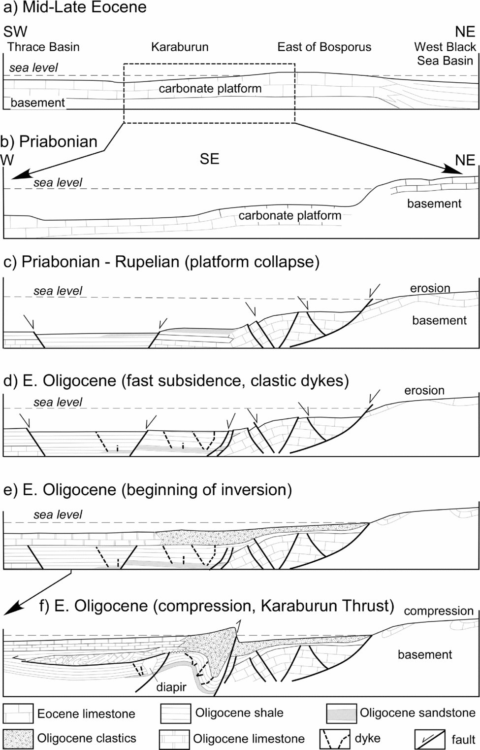
Figure 11. Tectonic evolution of the Karaburun area. (a) Middle to Late Eocene carbonate platform in the Thrace, Karaburun and neighbouring regions of the Black Sea. (b) The Priabonian carbonate platform in Karaburun. (c) Collapse of the platform because of the latest Eocene – Early Oligocene NE–SW extension. Note erosion of an uplift located to the east of the Bosporus. Its erosion can be a source of carbonate sandstones found in the clastic dykes. (d) Early Oligocene continuation of extension and accumulation of the deep-marine unit to the state suitable for clastic dyke formation. Dykes are rooted in erosional products of the Eocene carbonate platform. (e) Shallowing of the basin and formation of the shallow-marine limestone and shallow-marine sandstone units. Clasts of igneous rocks suggest erosion of the basement of the Eocene carbonate platform. (f) Inversion of the Ceylan Basin because of NE–SW compression, formation of the Karaburun Thrust and westerly directed submarine slumps.
Oktay, Eren & Sakınç (Reference Oktay, Eren and Sakınç1992) and Sakınç (Reference Sakınç1994) correctly concluded that the Eocene structural history of the Karaburun area is different from the history of the neighbouring Thrace Basin. Turgut, Türkarslan & Perinçek (Reference Turgut, Türkarslan and Perinçek1991) also described Middle to Late Eocene extension in the Thrace Basin. There, extensional structures have been identified only in the Sequence 1, which includes the Soğucak Formation and the older Eocene rocks (Turgut & Eseller, Reference Turgut and Eseller2000), but they do not cut the Ceylan Formation, which constitutes the Sequence 2, or may cross its lowest part. The outlined structural history of the Thrace Basin has been adopted by many researchers (Perinçek, Reference Perinçek1987; Görür & Okay, Reference Görür and Okay1996; Coşkun, Reference Coşkun1997, Reference Coşkun2000; Okay, Yurtsever & Siyako, Reference Okay, Yurtsever and Siyako2006; Siyako & Huvaz, Reference Siyako and Huvaz2007). Our data imply a younger age for the extension in the Karaburun area (Fig. 11c) and its propagation to the north in respect to the Thrace Basin.
To the east of the Bosporus, the Eocene–Early Oligocene extensional structures are as yet unknown. There, the Santonian–Campanian Pontide magmatic arc is conformably overlain by the Maastrichtian–Lower Paleocene pelagic limestones that are 50–80m thick (Tüysüz, Reference Tüysüz1999; Gedik et al. Reference Gedik, Timur, Duru and Pehlivan2005; Özcan, Less & Kertesz, Reference Özcan, Less and Kertesz2007; Özcan et al. Reference Özcan, Okay, Özcan, Hakyemez and Altiner2012). Structurally higher is a horizon (350m thick) of debris flow material made up of angular blocks of Upper Cretaceous limestones that are embodied in a Ypresian matrix (Özcan, Less & Kertesz, Reference Özcan, Less and Kertesz2007). It is conformably overlain by Lutetian shallow-marine carbonates and clastic sediments and then by the unconformably overlying Upper Oligocene shales and marls. The Lower Oligocene rocks are not reported in this region (Gedik et al. Reference Gedik, Timur, Duru and Pehlivan2005). The pre-Oligocene rocks are involved into N-vergent thrusts. The Lutetian limestones can be tectonically correlated with the carbonate platform in the Karaburun area and Thrace Basin, though their stratigraphic age is slightly older (Less, Özcan & Okay, Reference Less, Özcan and Okay2011).
As mentioned in Section 3.b above, the contact between the Soğucak and Ceylan formations is represented by a normal fault (Fig. 5). Thus, we disagree with Oktay, Eren & Sakınç (Reference Oktay, Eren and Sakınç1992) and Sakınç (Reference Sakınç1994) who described a transgressive nature for the Ceylan Formation with the accumulation of coarse-grained clastic sediments at its base. In fact, these facies are exposed in the higher stratigraphic levels above the deep-marine unit and thus the real succession indicates the deepening of the Ceylan Sea (Fig. 11c, d). İslamoğlu et al. (Reference İslamoğlu, Harzhauser, Gross, Jiménez-Moreno, Coric, Kroh, Rögl and van der Made2010) reported fluctuations of the sea level during the deposition of the Ceylan Formation along the northern margin of the Thrace Basin and the appearance of endemic Paratethys mollusc fossils at this stratigraphic level. Uplift above sea level has been reported in the Binkılıç region (Fig. 1) where the δ13C isotope ratio in a Lower Oligocene shell indicates a ground water source (Ozturk & Frakes, Reference Ozturk and Frakes1995).
The Early Oligocene tectonic history of the Black Sea and Caspian regions is usually viewed as a result of crustal shortening and formation of an uplift separating Tethys and Paratethys (Rögl, Reference Rögl1998; Steininger & Wessely, Reference Steininger and Wessely2000; Popov et al. Reference Popov, Akhmetyev, Lopatin, Bugrova, Sychevskaya, Shcerba, Andreeva-Grigorovich, Zaporozhetz, Nikolayeva and Kopp2009). It is difficult to reconcile this view with our observations and the observations made in the neighbouring Thrace Basin, where all research agrees on the Eocene–Early Oligocene extensional tectonic setting. At the same time, the uplift between the Black Sea and the Thrace Basin coinciding with the present-day Strandja Mountains has been reconstructed for Priabonian time (Popov et al. Reference Popov, Akhmetyev, Lopatin, Bugrova, Sychevskaya, Shcerba, Andreeva-Grigorovich, Zaporozhetz, Nikolayeva and Kopp2009) and Early–Middle Eocene time (Siyako & Huvaz, Reference Siyako and Huvaz2007).
The Karaburun Thrust marks a drastic change in the geodynamic setting of the studied region and signifies an inversion of the Ceylan Basin. The turbiditic succession of the deep-marine shale unit has a calcareous composition that suggests local sources of clastic material (Soğucak Formation and its equivalents; Fig. 11c). Mud diapirs and clastic dykes carry to the surface only very rare clasts of the Late Cretaceous volcanic rocks and Palaeozoic(?) lower grade schists. The turbiditic character of the deep-marine shale, increase in its thickness to the north and the onlapping character of reflectors (Sipahioğlu & Menlikli, Reference Sipahioğlu and Menlikli2009) suggest locations of source areas in the south. Abundant igneous clasts in the shallow-marine sandstone unit indicate a rapid increase in erosion rate within the uplift between the Black Sea and the Thrace Basin (Fig. 11d, e). Note that the Lower Oligocene is absent to the east of the Bosporus (Gedik et al. Reference Gedik, Timur, Duru and Pehlivan2005), which indicates a rather complicated palaeogeography.
The Karaburun Thrust controls the facies changes in the Lower Oligocene shallow-marine sandstone and shallow-marine limestone units. Earlier elevated fluid pressure, indirectly testifying to a considerable thickness of the deep-marine shale unit, got an additional increase at the beginning of compression. At the same time, lithological changes in the country rocks created additional complexities for the distribution of clastic dykes and mud diapirs. Relationships between bedding, mud diapirs, clastic dykes and submarine slump surfaces suggest an intricate succession of formation.
Intrusion of the earliest clastic dykes was synchronous with the Late Eocene – Early Oligocene extension in the NE direction. The majority of the dykes consist of carbonate sandstones, which are not known in the exposed stratigraphic successions, and therefore should be rooted in a layer located above the impermeable Soğucak Formation and below the deep-marine shales (Fig. 11c, d). It is most likely that this layer was deposited near the uplift in the east and south.
The clastic dykes are concentrated in the hanging wall of the Karaburun Thrust and are related to an anticline where the fluid pressure was highest. Some of the dykes used planes of pre-existing normal faults but others were newly formed, especially those that have gentle dips (Fig. 9c) and cut bedding, having regular, consistent and gentle to moderate dip angles. These orientations of the dykes are abnormal (Anderson, Reference Anderson1951) and, if the orientation of bedding is stable as observations show, we should expect the rotation of the principal stresses. A dyke depicted in Figure 9b fits this expectation.
Slumping to the west from the high that was formed by the hanging wall of the Karaburun Thrust involves rocks of the shallow-marine limestone unit. These rocks have been transported to the deeper parts of the Ceylan Basin of sedimentation as observations near Durusu show (Figs 7b, 11f). There, coherently bedded shales identical to the deep-marine shale unit conformably overlie the limestones with slump structures. The described relationships suggest cross-cutting relationships between time and lithological boundaries. In turn, they allow the anticipation of a scale of slumping in order to use it in future event stratigraphic studies. On the other hand, the slump surface cuts clastic dykes and mud diapirs and thus brings up a problem of time constraints on the transition between extension and compression. A solution is impossible without detailed palaeontological studies.
Located nearby, the Middle–Late Miocene Thrace Fault System (Perinçek, Reference Perinçek1987, Reference Perinçek1991; Turgut, Türkarslan & Perinçek, Reference Turgut, Türkarslan and Perinçek1991) or the Thrace–Eskişehir Fault Zone (Sakınç, Yaltırak & Oktay, Reference Sakınç, Yaltırak and Oktay1999; Yaltırak, Reference Yaltırak2002) evolved as a dextral transtensional and transpressional fault zone of northwesterly strike. In the studied area it was responsible for the reactivation of some normal faults and the recent rise of the territory as the tilted fill of the karstic voids shows.
6. Conclusions
The Cenozoic stratigraphic succession of the Karaburun Peninsula starts with the Middle–Upper Eocene Soğucak Formation of massive reef limestones. They form part of an extensive carbonate platform in the northern part of the Thrace Basin and neighbouring parts of the Black Sea.
In Late Eocene – Early Oligocene time, the carbonate platform experienced a rapid subsidence and disruption because of NE–SW-oriented extension. The stratigraphic record of the very beginning of this process is not preserved in the studied region but stratigraphic correlation shows that the newly formed basin was framed by an uplift in the south separating it from the Thrace Basin. On a regional scale, this uplift separated Tethys and Paratethys from Early Oligocene time onwards. Lower Oligocene sediments are not known to the east of the Bosporus but a thick pile of turbidite was accumulated in the Black Sea and in Karaburun area at the very edge of this basin.
The Early Oligocene extensional faults have northwestern strikes oblique to the trend of the Black Sea coast and to the southern boundary of the West Black Sea Basin. Middle to Late Eocene extension is recorded by seismic data in the neighbouring Thrace Basin (Turgut & Eseller, Reference Turgut and Eseller2000); however, it is not known in regions to the east of the Bosporus. Extension in the Karaburun area most likely started during Eocene–Early Oligocene time as the change from the accumulation of reef limestone (the Soğucak Formation) to the deep-marine shale unit of the Ceylan Formation shows.
The NE-vergent Karaburun Thrust marks the inversion of the Karaburun Basin and a change of the deep-marine sedimentation of the lower part of the Ceylan Formation into shallow-marine, and controls the facies distribution in the hanging wall and footwall. Clastic dykes and mud diapirs cutting the deep-marine shale unit record a rather complicated history of the Early Oligocene transition from extension to compression. Injection of the majority of the clastic dykes was controlled by pre-existing normal faults and their propagation to higher stratigraphic levels. Structural relationships indicate a rather long history of dyke injections and the Karaburun Thrust also contributed to the dyke formation. Large-scale westward-directed submarine slumps have been detected in the hanging wall of the Karaburun Thrust.
The outlined stratigraphic and tectonic history of the Karaburun area and the neighbouring parts of the Thrace Basin differs from the Late Eocene to Early Oligocene history of the Paratethys southern margin where a compressional tectonic setting has been reconstructed because of the Neo-Tethyan Ocean closure. Lower Oligocene rocks and extensional faults are absent to the east of the Bosporus; Lutetian and older rocks are involved in N-directed thrusts there. Additional and more comprehensive studies are necessary in order to reveal all aspects that so complicate the geological evolution of such a vitally important region that has so long been one of the great hubs of human civilization.
Acknowledgements
We are grateful to Celal A. M. Şengör, Cengiz Zabci, Ali Değer Özbakır, Annique van der Boom, Mark Allen and anonymous reviewers for their extensive comments on an earlier version of this paper that significantly improved it.