1. Introduction
Deep seismic profiling of continental areas is a source of valuable data on a crustal structure and its geological evolution (see recent examples in Ito, Iwasaki & Thybo, Reference Ito, Iwasaki and Thybo2009). Among others, such studies provide important clues for a reconstruction of a crustal accretion history in areas where a crystalline basement is concealed and stratigraphic data on earliest continental platform sediments are fragmentary. However, scarcity of geological data often makes interpretation of deep seismic results difficult and ambiguous. One example is the East European Craton margin in central and northwestern Poland and in northern Germany, which has been the subject of divergent interpretations for over two decades (e.g. most recently, Bayer et al. Reference Bayer, Grad, Pharaoh, Thybo, Guterch, Banka, Lamarche, Lassen, Lewerenz, Scheck and Marotta2002; Grad, Guterch & Mazur, Reference Grad, Guterch, Mazur, Winchester, Pharaoh and Verniers2002; Dadlez, Grad & Guterch, Reference Dadlez, Grad and Guterch2005).
The SE Polish sector of the craton margin is geologically much better constrained, as pre-Devonian strata are either exposed (in the Holy Cross Mts) or documented in numerous boreholes (Fig. 1; Dadlez, Reference Dadlez2001). Despite relatively firm geological constraints, no agreement exists so far as to the geological structure and accretion history, and proposed interpretations range from those assuming a wide extent of the craton to the west (e.g. Żelaźniewicz, Reference Żelaźniewicz1998), to mobilistic concepts envisaging different exotic terrane configurations (e.g. Unrug, Harańczyk & Chocyk-Jamińska, Reference Unrug, Harańczyk and Chocyk-Jamińska1999). Recently, this area has been covered by a network of the CELEBRATION 2000 deep refraction seismic profiles (Guterch et al. Reference Guterch, Grad, Keller, Posgay, Vozar, Špičák, Brueckl, Hajnal, Thybo and Selvi2003). The geological interpretations of the CELEBRATION 2000 data were focused on particular profiles, however, and did not involve analysis of the entire material against current regional geological and geophysical constraints (Malinowski et al. Reference Malinowski, Żelaźniewicz, Grad, Guterch and Janik2005; Janik et al. Reference Janik, Grad, Guterch, Dadlez, Yliniemi, Tiira, Keller and Gaczyński2005; Środa et al. Reference Środa, Czuba, Grad, Guterch, Tokarski, Janik, Rauch, Keller, Hegedűs and Vozár2006; Grad et al. Reference Grad, Guterch, Keller, Janik, Hegedűs, Vozár, Ślączka, Tiira and Yliniemi2006a).

Figure 1. Location of the study area in southeastern Poland against the geological framework of pre-Permian Central Europe (partly after Winchester et al. Reference Winchester, Pharaoh, Verniers, Winchester, Pharaoh and Verniers2002).
In this study we compare the consistent set of the velocity (Vp) models of the crust with the updated geological and potential fields data. We took the opportunity to include, among other things, the results of recent projects such as the PACE Programme (Winchester, Pharaoh & Verniers, Reference Winchester, Pharaoh, Verniers, Winchester, Pharaoh and Verniers2002) and the Palaeozoic Accretion of Poland Project (Nawrocki & Poprawa, Reference Nawrocki and Poprawa2006). The main aim was to establish if and to what extent the crustal velocity structure preserves memory of Early Palaeozoic and earlier tectonic events, and to determine the influence of Variscan and later tectonism on the present crustal geometry. It is hoped that the results of such comparison will also prove useful for future interpretations of continental areas with less well-constrained geological history, particularly East European Craton margin segments in central and NW Poland and in northern Germany.
2. Materials and Methods
Previous DSS (deep seismic sounding) investigations (Guterch et al. Reference Guterch, Grad, Materzok and Toporkiewicz1983, Reference Guterch, Grad, Materzok and Perchuć1986; Perchuć, Reference Perchuć1984) were completed using the ‘continuous’ profiling method, with 100 or 200 m distances between the channels. The distances between the shot points were 45–90 km, and recordings were carried out in the distance interval from 50–90 to 200–280 km from each shot point. The disadvantage of this technique was that records started at 50–90 km from the shot, and as a result, information about the uppermost 10–15 km of the structure was missing. Thus, velocities in the earlier interpretations were significantly overestimated (by about 0.2–0.3 km s−1) as were also effective depths of the Moho (by a few kilometres).
Results of 2-D modelling and preliminary geological interpretation along the main profiles of the international CELEBRATION 2000 Programme were published by Środa et al. (Reference Środa, Czuba, Grad, Guterch, Tokarski, Janik, Rauch, Keller, Hegedűs and Vozár2006; CEL01 and CEL04), Malinowski et al. (Reference Malinowski, Żelaźniewicz, Grad, Guterch and Janik2005; CEL02), Janik et al. (Reference Janik, Grad, Guterch, Dadlez, Yliniemi, Tiira, Keller and Gaczyński2005; TTZ-CEL03) and Grad et al. (Reference Grad, Guterch, Keller, Janik, Hegedűs, Vozár, Ślączka, Tiira and Yliniemi2006a; CEL05), whereas the results of 3-D first arrival tomography were presented by Malinowski et al. (Reference Malinowski, Grad and Guterch2008, Reference Malinowski, Środa, Grad and Guterch2009). Subsequently, eight additional profiles were interpreted using the 2-D ray tracing technique, and all 13 profiles were jointly re-interpreted with verification and adjustments of the models at crossing points (Janik et al. Reference Janik, Grad and Guterch2009). For the purpose of the present study, ten main and supplementary profiles were selected (Fig. 2), excluding those located outside the study area.

Figure 2. Location of the studied CELEBRATION 2000 profiles against the sub-Cenozoic geology of SE Poland (after Dadlez, Marek & Pokorski, Reference Dadlez, Marek and Pokorski2000, simplified). Distances in the profiles are in kilometres.
The velocity and depth uncertainties of models derived by 2-D forward modelling are in the range of ± 0.1 km s−1 and ± 1 km, in areas where a crustal structure is relatively simple, and ± 0.2 km s−1 and ± 2 km for a complicated structure, respectively (e.g. Janik et al. Reference Janik, Yliniemi, Grad, Thybo and Tiira2002; Grad et al. Reference Grad, Jensen, Keller, Guterch, Thybo, Janik, Tiira, Yliniemi, Luosto, Motuza, Nasedkin, Czuba, Gaczyński, Środa, Miller, Wilde-Piórko, Komminaho, Jacyna and Korabliova2003, Reference Grad, Guterch, Keller, Janik, Hegedűs, Vozár, Ślączka, Tiira and Yliniemi2006a, Reference Grad, Guterch, Mazur, Keller, Špičák, Hrubcová and Geissler2008). For additional profiles uncertainties can be slightly bigger. A horizontal resolution in ray tracing technique is about 20 km, or less for well-documented data.
Analysed CELEBRATION 2000 data revealed strong azimuthal variation of the Vp velocity in the upper–middle crust (depth 8–17 km), unlikely to be caused by crustal inhomogeneity (Środa, Reference Środa, Czuba, Grad, Guterch, Tokarski, Janik, Rauch, Keller, Hegedűs and Vozár2006). This was explained by upper–middle crustal seismic anisotropy and was investigated by the anisotropic delay-time inversion. The results indicated 8–12 % anisotropy (Vp = 5.6–6.4 km s−1) with a fast velocity axis directed WNW–ESE in agreement with a structural grain in the area, particularly with the regional strike of folded Ediacaran and Palaeozoic complexes (Środa, Reference Środa, Czuba, Grad, Guterch, Tokarski, Janik, Rauch, Keller, Hegedűs and Vozár2006).
Earlier results of potential fields studies were summarized by Dadlez (Reference Dadlez2001). More recent investigations that were considered in the present study include Grabowska & Bojdys (Reference Grabowska and Bojdys2001), Petecki et al. (Reference Petecki, Polechońska, Cieśla and Wybraniec2003) and Królikowski (Reference Królikowski2006). Previous geological work on the study area, with special emphasis on its Variscan and earlier structure, was summarized by Dadlez, Kowalczewski & Znosko (Reference Dadlez, Kowalczewski and Znosko1994) and Dadlez (Reference Dadlez2001). The most important recent results are related to the international PACE Project (Winchester, Pharaoh & Verniers, Reference Winchester, Pharaoh, Verniers, Winchester, Pharaoh and Verniers2002) and the Palaeozoic Accretion of Poland Project (Nawrocki et al. Reference Nawrocki, Żylińska, Buła, Grabowski, Krzywiec and Poprawa2004, Reference Nawrocki, Dunlap, Pecskay, Krzemiński, Żylińska, Fanning, Kozłowski, Salwa, Szczepanik and Trela2007; Nawrocki & Poprawa, Reference Nawrocki and Poprawa2006). The updated results of these and other relevant studies will be reviewed in the following section.
3. Critical overview of pre-Variscan geology
The analysed area is located between the margin of the East European Platform in the east and the Variscan foreland basin (Upper Silesian Coal Basin) in the southwest (Fig. 1). Its southern boundary corresponds approximately to the Carpathian orogenic front, whereas in the northwest it is bounded by the Grójec Fault (Fig. 2). The latter is commonly interpreted as a deep-seated tectonic line reactivated at the turn of the Cretaceous and Palaeogene to form the NW boundary of the Holy Cross segment of the Mid-Polish Swell, an inversion structure developed along the craton margin (e.g. Żelichowski, Reference Żelichowski1983; Janik et al. Reference Janik, Yliniemi, Grad, Thybo and Tiira2002).
3.a. East European Platform and its margin
In the present study we adopt the concept of the platform margin as a narrow linear zone striking SE–NW, termed the Teisseyre–Tornquist Zone (TTZ) (Dadlez, Reference Dadlez1987; Dadlez, Grad & Guterch, Reference Dadlez, Grad and Guterch2005). It separates the stable Precambrian East European Platform from its mobile foreland, the Palaeozoic Platform of Central and Western Europe. This first-order European lithospheric boundary (cf. e.g. Pharaoh, Reference Pharaoh1999) was variably placed, depending on both acquisition of new data and changing geological–geophysical ideas. In SE Poland it was initially drawn by Znosko (Reference Znosko1962) along the NE flank of the Lublin Trough (see also Jubitz et al. Reference Jubitz, Znosko, Franke and Garetsky1986). Thereafter it was placed along the SW boundary of the trough (Znosko, Reference Znosko1975, Reference Znosko1998; Brochwicz-Lewiński, Pożaryski & Tomczyk, Reference Brochwicz-Lewiński, Pożaryski and Tomczyk1981; Dadlez, Reference Dadlez1982; see also Pożaryski, Reference Pożaryski1990). Żelichowski (Reference Żelichowski1979) claimed, mainly based on the results of the earlier seismic refraction data, that the Radom-Kraśnik Elevation west of the Lublin Trough (Fig. 3) is a part of the stable East European Platform. Pożaryski & Nawrocki (Reference Pożaryski and Nawrocki2000) moved the platform margin further to the southwest, to the Skrzynno Fault zone (Fig. 2), while Dadlez (Reference Dadlez2001) proposed that the cratonic crust extends to the Holy Cross Fault. According to Żelaźniewicz (Reference Żelaźniewicz1998) and Malinowski et al. (Reference Malinowski, Żelaźniewicz, Grad, Guterch and Janik2005), the platform, conceived as the attenuated Baltica crust, extends still further to the southwest, to the Kraków–Lubliniec Fault. A similar extent of Baltica was advocated by Cocks & Torsvik (Reference Cocks and Torsvik2005, fig. 2) and Jaworowski & Sikorska (Reference Jaworowski and Sikorska2006).

Figure 3. Sub-Permian geological map of SE Poland (after Pożaryski & Dembowski, Reference Pożaryski and Dembowski1983, modified) showing main regional units of the Variscan foreland. For other explanations see Figure 2.
Recently, Królikowski (Reference Królikowski2006) reaffirmed the long-recognized (cf. Pożaryski & Kotański, Reference Pożaryski and Kotański1979) correspondence between the East European Platform margin and the magnetic provinces boundary. The narrow magnetic gradient zone parallels the Nowe Miasto–Zawichost Fault, whose activity affected both Permian–Mesozoic subsidence and ensuing late Cretaceous–Palaeogene inversion (Figs 2, 4a; Krzywiec, Reference Krzywiec2007, Reference Krzywiec2009). The fault corresponds also to the narrow positive gravity anomaly which is probably related to deep-seated sources (Grabowska & Bojdys, Reference Grabowska and Bojdys2001). Based on the results of potential fields studies it thus seems probable that the above fault is a younger expression of the TTZ (Grabowska & Bojdys, Reference Grabowska and Bojdys2001), thus confirming the concept of Żelichowski (Reference Żelichowski1979).

Figure 4. Maps of the potential fields of the study area in SE Poland with a location of selected tectonic elements (explained in Figs 2, 3). (a) Magnetic anomalies map (after Petecki et al. Reference Petecki, Polechońska, Cieśla and Wybraniec2003 and Królikowski, Reference Królikowski2006). H and L are areas of high and low magnetic anomaly (values given in nanoteslas). The distribution of volcanogenic Lower Carboniferous rocks is after Żelichowski & Kozłowski (Reference Żelichowski and Kozłowski1983). (b) Bouguer gravity anomalies map displayed as harmonic relief image illuminated from the NW (cf. Wybraniec, Reference Wybraniec1999). H and L are areas of high and low gravity anomaly (calibration in milligals). CS – Early Palaeozoic suture west of the HCM area (after Narkiewicz, Reference Narkiewicz2002; compare the text for further explanation), FSS – Fennoscandia–Sarmatia Suture, GF – Grójec Fault, HCF – Holy Cross Fault; IZF – Izbica–Zamość Fault, KFZ – Kock Fault Zone, KLF – Kraków–Lubliniec Fault, NMZF – Nowe Miasto–Zawichost Fault, SF – Skrzynno Fault, UKF – Ursynów–Kazimierz Fault.
The crust of western East European Platform was formed due to a collision of the Palaeoproterozoic Fennoscandia and Archaean Sarmatia 1.84–1.80 Ga ago (Bogdanova et al. Reference Bogdanova, Gorbatschev, Grad, Janik, Guterch, Kozlovskaya, Motuza, Skridlaite, Starostenko, Taran, Gee and Stephenson2006). The suture between the two plates strikes SW–NE and continues in the basement of a central segment of the Lublin Basin (Fig. 1). A complex pattern of positive and negative magnetic anomalies in the elevated part of the East European Platform reflects the SW–NE strike of the structural grain of the Precambrian basement (Fig. 4a). The high-amplitude anomalies pattern becomes more uniform SW of the Kock Fault Zone, which also marks the NE limit of the Małopolska Gravity High Zone (Królikowski, Petecki & Żółtowski, Reference Królikowski, Petecki and Żółtowski1999; Dadlez, Reference Dadlez2001). Towards the southeast, the magnetic anomaly pattern typical for the elevated East European Platform becomes less clear, as does the contrast with the uniform ‘Lublin pattern’. The Narol Unit was distinguished in this area by Janik et al. (Reference Janik, Grad, Guterch, Dadlez, Yliniemi, Tiira, Keller and Gaczyński2005), based on data from the SE termination of the CEL03 profile. Part of the Małopolska Gravity High NE of the Nowe Miasto–Zawichost Fault (Fig. 4b) is controlled by a higher density of the crystalline crust and lithospheric mantle (Królikowski, Petecki & Żółtowski, Reference Królikowski, Petecki and Żółtowski1999; Grabowska & Bojdys, Reference Grabowska and Bojdys2001; Malinowski et al. Reference Malinowski, Żelaźniewicz, Grad, Guterch and Janik2005). The maximum density (2.83–2.98 g cm−2 according to different authors) occurs in the basement of the Lublin Trough and is interpreted as a zone containing diorite or diabase intrusions.
The southwestern East European Platform margin was formed by Neoproterozoic rifting of the Vendian Pangaea, also termed Rodinia or Pannotia, which led to establishment of the separate Baltica continent (Nikishin et al. Reference Nikishin, Ziegler, Stephenson, Cloetingh, Furne, Fokin, Arshov, Bolotov, Korotaev, Alekseev, Gorbachev, Shipilov, Lankreijer, Bembinova and Shalimov1996; Poprawa & Pacześna, Reference Poprawa and Pacześna2002). The initial rifting phase post-dated the Sveconorwegian (Grenvillian) orogeny (c. 900 Ma; Żelaźniewicz, Reference Żelaźniewicz1998), probably in the time interval 700–600 Ma (Nawrocki & Poprawa, Reference Nawrocki and Poprawa2006). A major second rifting event occurred between 600 and 550 Ma (Moczydłowska, Reference Moczydłowska1995; Winchester, Pharaoh & Verniers, Reference Winchester, Pharaoh, Verniers, Winchester, Pharaoh and Verniers2002), indicated by Ediacaran subsidence and depositional and magmatism patterns along the East European Platform margin (Poprawa & Pacześna, Reference Poprawa and Pacześna2002; Pacześna, Reference Pacześna2006). Associated terminal events of the basaltic magmatism are radiometrically dated as 551 ± 4 Ma (Compston et al. Reference Compston, Sambridge, Reinfrank, Moczydłowska, Vidal and Claesson1995). The positive magnetic and gravimetric anomalies in the basement of the Lublin basin probably represent deep-seated magmatic rocks related to rifting (Malinowski et al. Reference Malinowski, Żelaźniewicz, Grad, Guterch and Janik2005). Thus, near the Ediacaran–Cambrian boundary the Tornquist Ocean and Baltica continent were formed, with a passive margin of the latter persisting until the early Ludlow (Nawrocki & Poprawa, Reference Nawrocki and Poprawa2006).
3.b. Upper Silesian Block
The crystalline basement termed the Upper Silesian Block forms the northern part of the Brunovistulicum unit (Buła, Jachowicz & Żaba, Reference Buła, Jachowicz and Żaba1997). The basement, consolidated in the Cadomian orogeny (Finger et al. Reference Finger, Hanzl, Pin, Von Quadt, Steyrer, Franke, Haak, Oncken and Tanner2000), consists of various rock complexes, from the Archaean gneisses and amphibolites to the Ediacaran clastics affected by anchimetamorphism (Buła & Żaba, Reference Buła, Żaba, Jureczka, Buła and Żaba2005, Reference Buła and Żaba2008). It is unconformably overlain by continuous Lower–Middle to ?Upper Cambrian clastics (Moczydłowska, Reference Moczydłowska1997, Reference Moczydłowska1998; Buła & Żaba, Reference Buła, Żaba, Jureczka, Buła and Żaba2005) which are paraconformably covered mostly by the Devonian rocks (Buła, Jachowicz & Żaba, Reference Buła, Jachowicz and Żaba1997). The northeastern block boundary, presently corresponding to the Kraków–Lubliniec Fault, is interpreted as the trace of accretionary suture with the Małopolska Block, strongly overprinted by later Variscan deformation (Fig. 3; Żaba, Reference Żaba1999). The fault runs approximately along a zone of weak positive magnetic anomalies (Fig. 4a), probably related to magmatic bodies associated with the suture zone. It also forms a boundary separating areas with different patterns of gravity anomalies (Fig. 4b).
Most authors interpret the Upper Silesian Block as a terrane of a Gondwanan or Peri-Gondwanan provenance (Dadlez, Kowalczewski & Znosko, Reference Dadlez, Kowalczewski and Znosko1994; Moczydłowska, Reference Moczydłowska1997; Unrug, Harańczyk & Chocyk-Jamińska, Reference Unrug, Harańczyk and Chocyk-Jamińska1999; Belka et al. Reference Belka, Valverde-Vaquero, Dörr, Ahrendt, Wemmer, Franke, Schäfer, Winchester, Pharaoh and Verniers2002; Nawrocki et al. Reference Nawrocki, Żylińska, Buła, Grabowski, Krzywiec and Poprawa2004) or derived from the Uralian margin of Baltica (Pharaoh, Reference Pharaoh1999). According to Winchester, Pharaoh & Verniers (Reference Winchester, Pharaoh, Verniers, Winchester, Pharaoh and Verniers2002), it was partly separated from the Amazonian part of Pannotia between late Proterozoic and Early Cambrian times, and finally detached from Gondwana before the Early Ordovician. The age of accretion is variously interpreted as: late Viséan (Unrug, Harańczyk & Chocyk-Jamińska, Reference Unrug, Harańczyk and Chocyk-Jamińska1999), pre-late Early Devonian (Moczydłowska, Reference Moczydłowska1997; Belka et al. Reference Belka, Ahrendt, Franke, Wemmer, Franke, Haak, Oncken and Tanner2000), post-Ludlow and pre-Early Devonian (Nawrocki et al. Reference Nawrocki, Żylińska, Buła, Grabowski, Krzywiec and Poprawa2004; Nawrocki & Poprawa, Reference Nawrocki and Poprawa2006), or Neoproterozoic (Żelaźniewicz, Reference Żelaźniewicz1998; Malinowski et al. Reference Malinowski, Żelaźniewicz, Grad, Guterch and Janik2005; Jaworowski & Sikorska, Reference Jaworowski and Sikorska2006).
3.c. Małopolska and Łysogóry blocks
The crystalline basement of the area between the Upper Silesian Block and the SW part of the Lublin Basin is unknown. The magnetic map shows here a widespread, almost uniform negative anomaly (Fig. 4a; Petecki et al. Reference Petecki, Polechońska, Cieśla and Wybraniec2003; Królikowski, Reference Królikowski2006). Nevertheless, two distinct regional units, the Małopolska and Łysogóry blocks, are here commonly defined based on Palaeozoic palaeotectonic and depositional patterns (e.g. Brochwicz-Lewiński, Pożaryski & Tomczyk, Reference Brochwicz-Lewiński, Pożaryski and Tomczyk1981; Dadlez, Kowalczewski & Znosko, Reference Dadlez, Kowalczewski and Znosko1994; Buła, Jachowicz & Żaba, Reference Buła, Jachowicz and Żaba1997; Belka et al. Reference Belka, Ahrendt, Franke, Wemmer, Franke, Haak, Oncken and Tanner2000). The block boundary is mapped in the Holy Cross Mts as the Holy Cross Fault running about 10–15 km north of the line separating two different gravity patterns (Fig. 4b). The Łysogóry Block displays a uniformly strong positive anomaly, whereas in the Małopolska Block, weaker positive and negative anomalies match the Palaeozoic fold pattern striking WNW–ESE. The interpreted SE extension of the Holy Cross Fault tangentially joins the linear positive anomaly representing the extension of the Nowe Miasto-Zawichost Fault.
The oldest rocks recognized in the Małopolska Block are strongly folded and partly weakly metamorphosed flyschoid clastics several kilometres thick, of Ediacaran to Middle Cambrian age (Moczydłowska, Reference Moczydłowska1995; Buła, Jachowicz & Żaba, Reference Buła, Jachowicz and Żaba1997; Moryc & Łydka, Reference Moryc and Łydka2000). Kowalski (Reference Kowalski1983) documented the biostratigraphically dated Lower Cambrian overlying Precambrian (dated radiometrically at 549 Ma by Compston et al. Reference Compston, Sambridge, Reinfrank, Moczydłowska, Vidal and Claesson1995) with a slight erosional unconformity. In the southern Holy Cross Mts, the Upper Cambrian clastics truncate folded and thrusted older Cambrian strata (Gągała, Reference Gągała2005; Kowalczewski, Żylińska & Szczepanik, Reference Kowalczewski, Żylińska, Szczepanik, Skompski and Żylińska2006), and are in turn involved in successive deformations preceding the late Tremadocian. Ensuing deposition of about 300 metres of a marine epicontinental Ordovician to upper Ludlow succession was terminated by ‘late Caledonian’ ( = latest Silurian–earliest Devonian) compressional deformations (Dadlez, Kowalczewski & Znosko, Reference Dadlez, Kowalczewski and Znosko1994).
In this study we adopted a narrower definition of the Łysogóry Block, excluding the Radom–Kraśnik Elevation in the northeast (Fig. 3). The latter unit, formed due to the Variscan inversion, has been incorporated into the marginal part of the East European Platform (Narkiewicz, Reference Narkiewicz2007). The oldest rocks known from the Łysogóry Block are the Middle–Upper Cambrian clastics. The Ordovician to Early Devonian sedimentary development is partly comparable to the equivalent strata in the Małopolska Block. Nevertheless, notable differences include much greater thickness and a continuous deposition, with only a subordinate unconformity formed in the Lochkovian. Moreover, recent tectonic studies document differences in a structural evolution of the Lower Palaeozoic complex in two regional units, particularly distinct in the Cambrian (Gągała, Reference Gągała2005; Salwa & Jarosiński, Reference Salwa, Jarosiński, Skompski and Żylińska2006; S. Salwa, unpub. Ph.D. thesis, Polish Geol. Inst. 2007). The above evidence, together with contrasting levels of thermal maturity of the Lower Palaeozoic strata (much greater in the north) confirms a palaeogeographic separation of two blocks during most of the Early Palaeozoic as proposed by Dadlez, Kowalczewski & Znosko (Reference Dadlez, Kowalczewski and Znosko1994) and Narkiewicz (Reference Narkiewicz2002).
Figure 5a–d shows a range of palaeotectonic interpretations of the Małopolska and Łysogóry blocks. The concept of the Neoproterozoic collisional orogen (Fig. 5a; Żelaźniewicz, Reference Żelaźniewicz1998; Malinowski et al. Reference Malinowski, Żelaźniewicz, Grad, Guterch and Janik2005; cf. the earlier concept of the Assyntian Orogen by Pożaryski & Tomczyk, Reference Pożaryski and Tomczyk1968) is incompatible with the contrasting depositional and palaeotectonic development of the Upper Silesian and Małopolska blocks during the Ediacaran to Cambrian transition (Moczydłowska, Reference Moczydłowska1995, Reference Moczydłowska1997; Buła, Jachowicz & Żaba, Reference Buła, Jachowicz and Żaba1997; Żaba, Reference Żaba1999; Moryc & Łydka, Reference Moryc and Łydka2000; Gągała, Reference Gągała2005; see also Cocks, Reference Cocks, Winchester, Pharaoh and Verniers2002). The idea is also inconsistent with the evidence of rifting along the present SW margin of the East European Platform at that time (Poprawa & Pacześna, Reference Poprawa and Pacześna2002). On the other hand, interpretations (Fig. 5b) invoking large-scale displacement of the Łysogóry Terrane (Pożaryski, Reference Pożaryski1990; Unrug, Harańczyk & Chocyk-Jamińska, Reference Unrug, Harańczyk and Chocyk-Jamińska1999) can also be excluded in view of palaeobiogeographic data (Cocks, Reference Cocks, Winchester, Pharaoh and Verniers2002; Cocks & Torsvik, Reference Cocks and Torsvik2005). Nevertheless, a translation of the Łysogóry Block in the Early Palaeozoic could explain the increased thickness of the Upper Cambrian relative to the East European Platform (Poprawa, Reference Poprawa2006), as well as the presence of distinct tectonic deformations in these strata in the northern Holy Cross Mts (S. Salwa, unpub. Ph. D. thesis, Polish Geol. Inst. 2007). Moreover, the increased Late Silurian subsidence may be due to strike-slip movement (Oczlon, Seghedi & Carrigan, Reference Oczlon, Seghedi and Carrigan2007) rather than to a development of a foreland basin of the North German–Polish collisional belt, as previously interpreted by Narkiewicz (Reference Narkiewicz2002).

Figure 5. Previous interpretations of the pre-Devonian geology of the study area in southeastern Poland.
Moczydłowska (Reference Moczydłowska1997) included both described blocks in the Avalonian accretionary belt, while Dadlez, Kowalczewski & Znosko (Reference Dadlez, Kowalczewski and Znosko1994) and Nawrocki et al. (Reference Nawrocki, Dunlap, Pecskay, Krzemiński, Żylińska, Fanning, Kozłowski, Salwa, Szczepanik and Trela2007) assumed that the Łysogóry Block has been essentially in place relative to the East European Craton since the late Neoproterozoic. Cocks (Reference Cocks, Winchester, Pharaoh and Verniers2002) envisaged direct palaeobiogeographic affinities of both the Łysogóry and Małopolska blocks with Baltica since the Cambrian (see also Cocks & Torsvik, Reference Cocks and Torsvik2005). Cocks (Reference Cocks, Winchester, Pharaoh and Verniers2002) also claimed that faunal evidence does not allow for relative strike-slip translations exceeding a few hundreds of kilometres. In turn, according to Belka et al. (Reference Belka, Ahrendt, Franke, Wemmer, Franke, Haak, Oncken and Tanner2000, Reference Belka, Valverde-Vaquero, Dörr, Ahrendt, Wemmer, Franke, Schäfer, Winchester, Pharaoh and Verniers2002), the Łysogóry Block, derived from the peri-Gondwanan belt, had been located close to Baltica since the Late Cambrian, while in the Silurian to Early Devonian it underwent dextral translation along the continental margin (Valverde-Vaquero et al. Reference Valverde-Vaquero, Dörr, Belka, Franke, Wiszniewska and Schastok2002; see also Winchester et al. Reference Winchester, Pharaoh, Verniers, Winchester, Pharaoh and Verniers2002). Dadlez, Kowalczewski & Znosko (Reference Dadlez, Kowalczewski and Znosko1994) and Narkiewicz (Reference Narkiewicz2002) assumed similar dextral strike-slip of the Małopolska Block, with its final accretion during latest Silurian–earliest Devonian times. Other authors interpreted the ultimate amalgamation in the late Silurian (Belka et al. Reference Belka, Ahrendt, Franke, Wemmer, Franke, Haak, Oncken and Tanner2000, Reference Belka, Valverde-Vaquero, Dörr, Ahrendt, Wemmer, Franke, Schäfer, Winchester, Pharaoh and Verniers2002; Winchester et al. Reference Winchester, Pharaoh, Verniers, Winchester, Pharaoh and Verniers2002), after the early Ordovician (Pharaoh, Reference Pharaoh1999) or near the Ediacaran/Cambrian boundary but with later subordinate translation at the turn of the Cambrian and Ordovician (Nawrocki et al. Reference Nawrocki, Dunlap, Pecskay, Krzemiński, Żylińska, Fanning, Kozłowski, Salwa, Szczepanik and Trela2007).
4. Comparison with CELEBRATION 2000 results
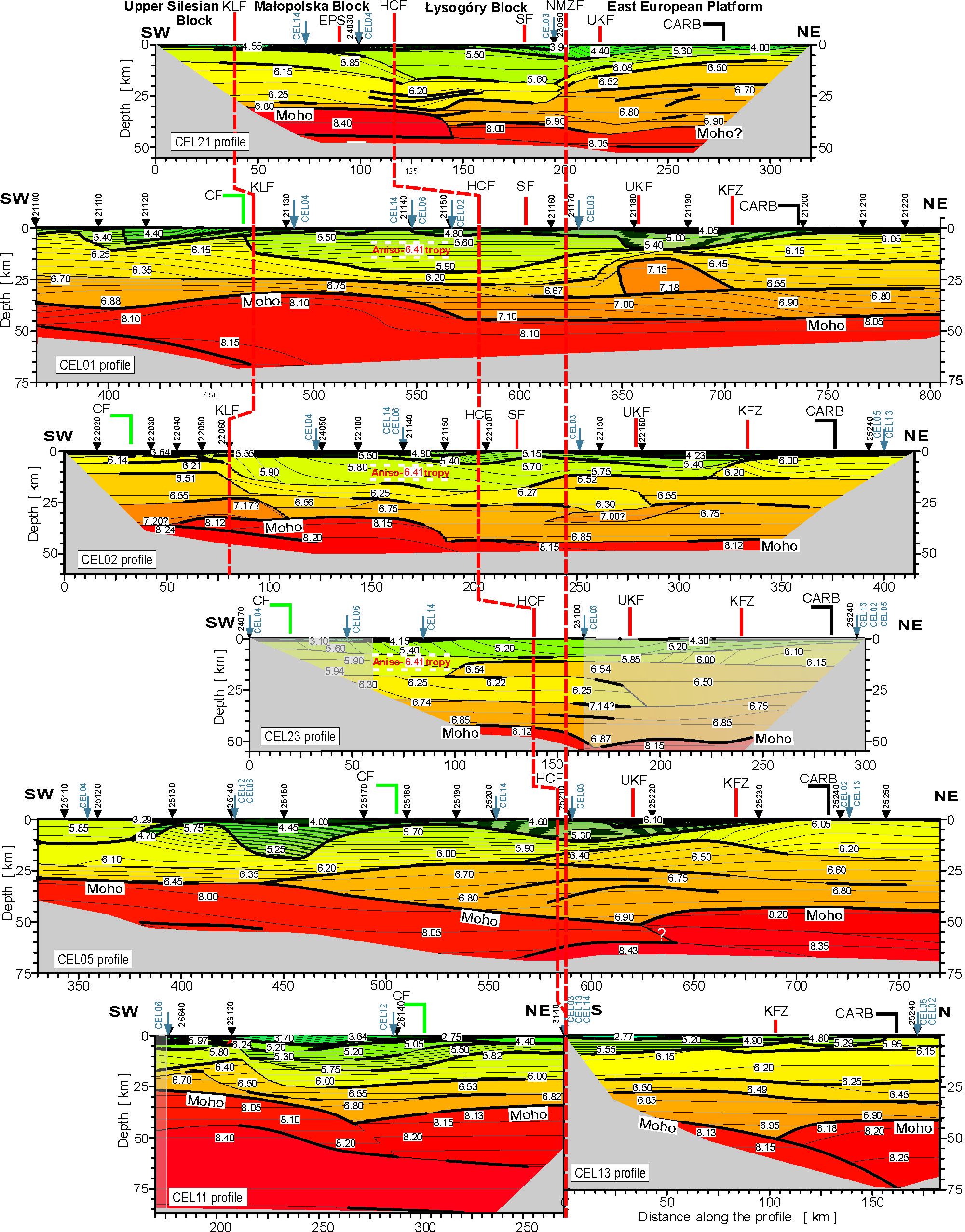
Figures 6 and 7 show the velocity (Vp) structure and Moho depth for the transversal (approximately SW–NE) and longitudinal/oblique profiles (approximately NW–SE) with the location of intersection points with selected regional boundaries including sutures between the blocks discussed above.

Figure 6. P-wave velocity structure of the studied CELEBRATION 2000 lines transversal to the TTZ (modified after Janik et al. Reference Janik, Grad and Guterch2009), compared to the position of the principal geological boundaries. For location of the profiles see Figure 2. Note the same vertical and horizontal scale of the cross-sections. Thin lines represent velocity isolines with values in km s−1 shown in white boxes. Heavy lines mark the seismic boundaries constrained by reflected and/or refracted arrivals. Black triangles and grey arrows show positions of shot points and intersections with other profiles, respectively. Horizontal black dashed lines in CEL01, CEL02 and CEL23 profiles mark zones of detected anisotropy in the intersection with CEL14 profile (compare the text for further explanation). Pale grey colours in CEL23 represent end parts of the profile with inconsistent system and lower accuracy of measurements. CARB – eastern extent of the Carboniferous; CF – Carpathian Front; for other explanations see Figure 4. For a colour version of this figure, please see online appendix at http://www.cambridge.org/journals/geo.

Figure 7. P-wave velocity structure of the studied CELEBRATION 2000 lines parallel and oblique to the TTZ (modified after Janik et al. Reference Janik, Grad and Guterch2009), compared to the position of the principal geological boundaries. GF – Grójec Fault; for other explanations see Figures 4 and 6. For a colour version of this figure, please see online appendix at http://www.cambridge.org/journals/geo.
4.a. East European Platform and its margin
The area to the northeast of the Kock Fault Zone is characterized by a ‘normal’, 40 to 45 km thick, cratonic East European Platform crystalline crust, with its typical three-layer structure (Grad et al. Reference Grad, Janik, Guterch, Środa and Czuba2006b; Guterch & Grad, Reference Guterch and Grad2006). The lower layer has Vp velocities 6.7–7.0 km s−1 and is 9 km to 18 km thick, the middle layer values are 6.45–6.62 km s−1 (10–13 km), while the upper one has velocities 6.0–6.25km s−1 (12–20 km) (Fig. 6). The uppermost layer, with Vp less than 5.5 km s−1, corresponds to Neoproterozoic and Phanerozoic sediments and volcanogenic rocks increasing in thickness southwestwards. The crust underlying the Lublin Basin depocentre has a similar structure but with a considerable variability of Vp pattern along the regional strike, seen in profiles CEL21 (NW) to CEL13 (SE). Notable is the occurrence of anomalous high-velocity ‘bodies’ of which the most outstanding (Vp = 7.15 km s−1) occurs in the middle crust in the CEL01 profile. In the CEL21 and CEL05 lines the zones of intracrustal reflections were found in a similar position. These phenomena probably represent a crust affected by basic Ediacaran syn-rift magmatism (see also Malinowski et al. Reference Malinowski, Żelaźniewicz, Grad, Guterch and Janik2005). Uniformly deep Moho but, at the same time, thinning of the crystalline crust compensated by a thicker low-velocity sedimentary layer can be explained by a passive-margin location at the Early Palaeozoic Baltica margin.
The Nowe Miasto-Zawichost Fault shows in the CEL21 and CEL23 profiles in a zone of Moho shallowing towards the southwest, whereas in CEL21, CEL01(?), CEL02 and CEL05 it roughly corresponds to a western termination of the middle crustal, East European Platform-type layer. This tectonic line crosses a wide gradient zone of the crystalline crust thinning which is mostly compensated by the low-velocity sedimentary layer, and with a parallel reduction of the lower layer seen in CEL21 and CEL 23. However, the lateral crustal changes are by no means sharply defined in the crustal models. It should also be stressed that they do not occur systematically along the TTZ strike (Fig. 6). Moreover, the Moho depth map does not show any distinct gradient correlated with the Nowe Miasto–Zawichost Fault zone (Fig. 8).

Figure 8. Depth to Moho in southeastern Poland compiled from the CELEBRATION 2000 data (after Janik et al. Reference Janik, Grad and Guterch2009, modified). Key tectonic elements are explained in Figures 2 and 3. Late Jurassic depocentre after Dadlez, Marek & Pokorski (Reference Dadlez, Marek and Pokorski1998). The boundary of the Narol Unit (Janik et al. Reference Janik, Grad, Guterch, Dadlez, Yliniemi, Tiira, Keller and Gaczyński2005) generally follows the Moho topography (see the text). The study area is marked with a dark grey frame.
The situation becomes even more complicated in the SE part of the study area. Here, a narrow zone of exceptionally thickened crust striking approximately SW–NE is clearly visible in CEL14 (260 km) and CEL03 (630 km) (Figs 7, 8). It corresponds to the NW boundary of the Narol Unit (Janik et al. Reference Janik, Grad, Guterch, Dadlez, Yliniemi, Tiira, Keller and Gaczyński2005), which may be correlated with the Fennoscandia–Sarmatia Suture (Figs 1, 8). The velocity structure of the CEL14 profile (Fig. 7) suggests that the crustal thickening oversteps the boundary between the East European Platform and the Łysogóry Block and enters the Małopolska Block. Such Moho topography could indicate that either the platform crust extends further to the southwest than earlier assumed or that the thickened crust corresponds to a transversal tectonic zone younger than the crustal pattern established in the Early Palaeozoic. Such a zone is, however, unknown based on present knowledge, while the extended East European Platform is incompatible with the evidence of a terrane character of the Małopolska Block discussed above.
4.b. Upper Silesian Block
The crystalline crust of the Upper Silesian Block is three-layered in the CEL02 profile (Fig. 6). The lower layer, 9–10 km thick, is characterized by Vp in the range 7.1–7.2 km s−1, the middle (14–15 km) has P-wave velocities 6.5–6.6 km s−1, whereas the values for the upper one (9–10 km) are 6.14–6.21 km s−1. The thickness of the uppermost low-velocity layer is less than 5 km, which corresponds to the thickness of the Phanerozoic sedimentary cover (e.g. Buła, Jachowicz & Żaba, Reference Buła, Jachowicz and Żaba1997). In the CEL01 line, located about 50 km to the southeast, the Moho boundary of the Upper Silesian Block is slightly deeper (33–36 km), whereas the crust consists of two layers separated by a distinct reflective boundary: the lower, 8–10 km thick, with Vp = 6.75–6.85 km s−1, and the upper (18–21 km) showing Vp = 6.15–6.35 km s−1. Differences in the Vp velocity distribution between the profiles confirm the complex structure of the Upper Silesian Block, also indicated by petrological variability in the crystalline basement (Buła & Żaba, Reference Buła and Żaba2008). The suture between the Upper Silesian and Małopolska blocks (present Kraków–Lubliniec Fault) will be discussed below in Section 5.a.
4.c. Małopolska and Łysogóry blocks
The Łysogóry Block crust is clearly represented only in the CEL02, CEL01 and CEL21 profiles, whereas in CEL23 it merely forms a narrow strip hardly distinguishable from the neighbouring units. The Moho depth is identical to that of the East European Platform in CEL01 and CEL02, and it is shallower by about 5 km in CEL21 (Fig. 6). It is, however, characterized by a thinner crystalline crust, mostly lacking the typical middle layer of the East European Platform (except for the CEL01 profile), and with a thickened uppermost low-velocity layer.
The Małopolska Block has a two-layered crust (Fig. 6), and a generally shallower Moho than in neighbouring blocks (30–35 km). The low-velocity sedimentary and low-grade metasedimentary layer is exceptionally thick, even assuming the role of seismic anisotropy (see below). This leads to a minimum thickness of the crystalline crust with much reduced high-velocity lower layer. A notable exception is the SE part of the block, adjoining the Narol Unit (CEL14, Fig. 7). An unusual ‘inverted’ velocity structure is seen in the CEL23 profile with the characteristic lower velocity tongue in the NE (Vp = 6.22–6.25 km s−1) situated beneath the layer characterized by Vp typical of the middle East European Platform crust (6.54 km s−1).
Although there is a general difference in velocity structure and Moho depth between the Małopolska and Łysogóry blocks, the suture between the units, that is, the Holy Cross Fault, is not clearly reproduced in the Vp velocity patterns (Fig. 6). It may be nevertheless noted that in CEL01 and CEL02 the fault is close to the Moho step, while in the CEL21 it falls in a zone of laterally changing thickness proportion of the uppermost and upper crustal layers, marked by distinct reflective boundaries. The relationship between the mapped trace of the fault and zones of horizontal gradients in the crustal structure thus changes along the strike from one profile to another. The step in Moho, commonly occurring close to the fault, is generally offset to the southwest (Fig. 6).
The CEL11 profile is exceptional with respect to the above trends, in showing the presence of a thin (about 7–8 km) middle crystalline crustal layer (Vp = 6.53–6.55 km s−1) between the East European Platform and the Carpathians. However, the intersecting part of the CEL14 profile does not reveal a typical middle layer, but merely a thin (4 km) intercalation with Vp = 6.41 km s−1 within the layer with Vp = 6.15–6.20km s−1. In turn, in CEL11 a thin (13 km) two-layered crystalline crust occurs below an exceptionally thick (22 km) layer with Vp ≤ 6.0 km s−1.
The thickness of the uppermost low-velocity layer (Vp ≤ 6.0 km s−1) reaches 20–22 km across large parts of the area between the Upper Silesian Block and the East European Platform (Fig. 6). At the same time, in the longitudinal and oblique sections (Fig. 8) the modelled thicknesses are considerably lower due to a seismic anisotropy (Środa, Reference Środa2006). Areas of anisotropy in profiles running SW–NE (approximate direction of ‘slow’ velocities) are shown in Figure 6 by black dashed lines, with corresponding value of ‘fast’ velocity (about 6.4 km s−1 in a WNW–ESE direction).
5. Causes of a mismatch between interpreted structure and seismic data: a discussion
From the above comparison of the seismic velocity models with geological data, it appears that although there is a general agreement between interpreted pattern of regional units and the velocity structure, the sutures between the blocks are much less clearly reflected in the velocity models. These differences may be partly related to a limited power of resolution of the refraction seismic in defining relatively narrow nearly vertical crustal boundaries. At the same time, however, they may also indicate existing complexity in a geological structure connected with a Variscan and later tectonic overprint.
5.a. Resolution of refraction seismic data
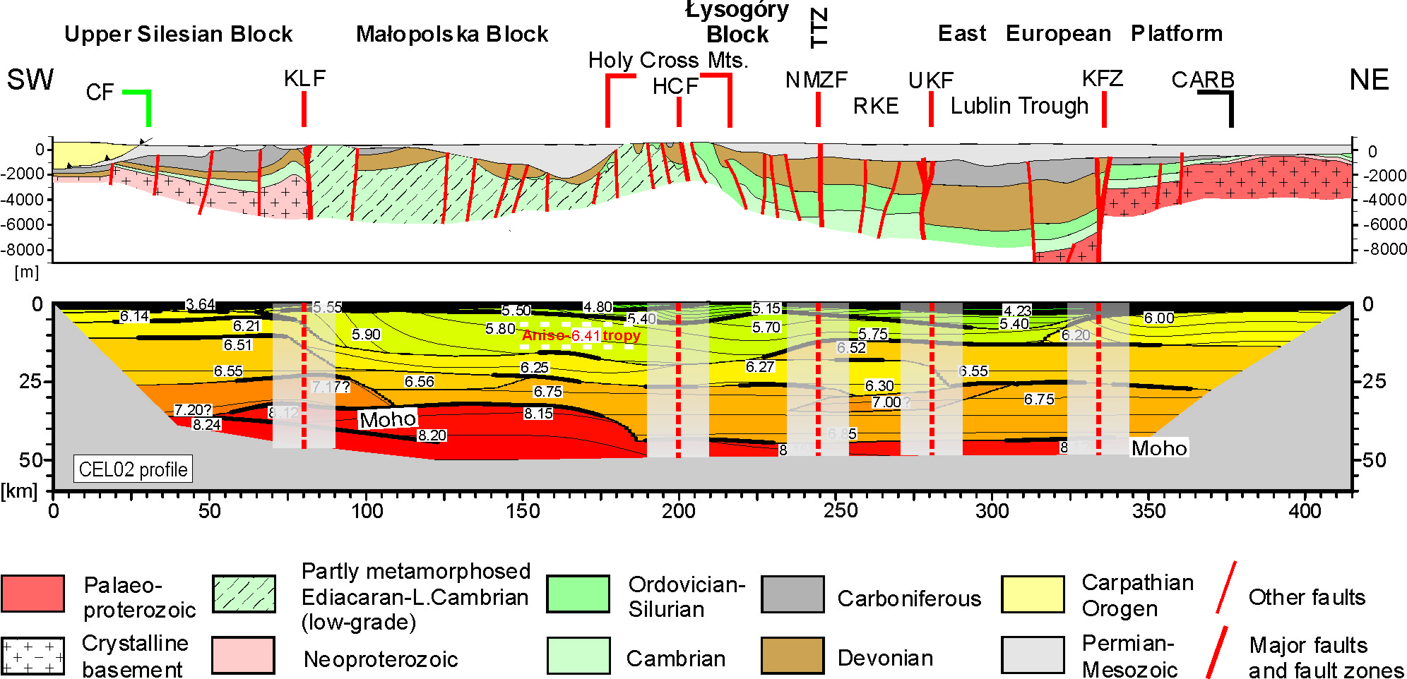
The Kraków–Lubliniec Fault (Buła, Jachowicz & Żaba, Reference Buła, Jachowicz and Żaba1997) may serve as a model example to test resolution of the CELEBRATION 2000 data in defining tectonic sutures between the analysed regional units. It is widely accepted that the fault follows a pre-Devonian accretionary suture between the Upper Silesian Block and Małopolska Block (e.g. Moczydłowska, Reference Moczydłowska1997; Żelaźniewicz, Reference Żelaźniewicz1998; Belka et al. Reference Belka, Valverde-Vaquero, Dörr, Ahrendt, Wemmer, Franke, Schäfer, Winchester, Pharaoh and Verniers2002). The suture was reactivated in Devonian and Carboniferous times mainly as a dextral strike-slip dislocation in alternating transtensional and transpressive regimes (Bogacz & Krokowski, Reference Bogacz and Krokowski1981; Żaba, Reference Żaba1999). The crustal scale of the Variscan fault is indicated by an associated bimodal magmatism. The terminal Variscan deformations led to the formation of an approximately 0.5 km broad zone of nearly parallel, vertical or steeply inclined reverse faults (Buła, Jachowicz & Żaba, Reference Buła, Jachowicz and Żaba1997; Żaba, Reference Żaba1999). This narrow zone is located in the CEL01 and CEL02 profiles approximately in the middle of the transition between the crust of the Upper Silesian Block and that of the SW flank of the Małopolska Block (Figs 6, 9).

Figure 9. Comparison of the interpreted geology of the studied area (cross-section after Pożaryski & Dembowski, Reference Pożaryski and Dembowski1983, modified) with the Vp velocity structure in the CEL02 profile. Note the 20 km wide resolution windows of the principal tectonic zones interpreted as nearly vertical crustal discontinuities (compare the text for further explanation). RKE – Radom–Kraśnik Elevation; for other abbreviations see Figures 4 and 6. For a colour version of this figure, please see online appendix at http://www.cambridge.org/journals/geo.
It is thus apparent that the velocity models do not demonstrate a sharp vertical boundary. Instead, the associated horizontal velocity gradients form a transitional zone, about 20 km in width (Fig. 9). It may be assumed that this number is an approximation of a resolution power or interpretative window of the Vp velocity models with respect to defining approximately vertical crustal-scale discontinuities. Notably, this number is equal to the independently estimated horizontal resolution of the ray tracing technique (see above). The lower layer of the Upper Silesian Block (Vp = 7.1–7.2 km s−1) extends 20 km northeastwards beyond the interpretative window in the CEL02 profile (Fig. 9). This suggests that the Kraków–Lubliniec Fault zone dips northeastwards at about 45°. However, in view of the documented strike-slip character of the Variscan faulting, its inclination appears questionable. The other explanation, preferred here, assumes that the fault is vertical but offset in the lower crust due to horizontal decoupling in a more ductile environment.
Similar or lower values of an interpretative window (10–20 km) are implied by Stern & McBride (1999), who compared the reflection and refraction seismic results for several major well-constrained strike-slip zones, including Great Glen, San Andreas, Queen Charlotte and Alpine faults. The comparison demonstrated that regional strike-slip faults are nearly vertical and generally cross the entire crustal thickness. In some examples, their trace in seismic data disappears in the lower, reflective crust, usually regarded as more ductile. Depending on the magnitude of strike-slip and degree of lateral contrasts in the deformed crust, the fault zone may be associated with variable Moho topography (step in Moho, crustal keel) and/or lateral gradients in a velocity structure.
5.b. Influence of post-Silurian tectonic overprint
The main stages of the geological evolution of the study area, and their possible impact on the structure of the Earth's crust are summarized in Table 1. Consistent patterns of Middle to Late Devonian basin development (Narkiewicz, Reference Narkiewicz2007) are in accordance with the widely accepted idea that the accretion of the main crustal blocks was already completed by the Early Devonian (see also e.g. Dadlez, Kowalczewski & Znosko, Reference Dadlez, Kowalczewski and Znosko1994; Belka et al. Reference Belka, Valverde-Vaquero, Dörr, Ahrendt, Wemmer, Franke, Schäfer, Winchester, Pharaoh and Verniers2002). Nevertheless, later multi-phase tectonism could have significantly modified the initial pre-Devonian pattern, partly by reactivation of the earlier-formed sutures, major fault zones, and other tectonic discontinuities.
Table 1. Main tectonic events and processes and their possible impact on a crustal structure of SE Poland

5.b.1. Cenozoic tectonism
Between the late Eocene and early Miocene, the Outer Carpathian basins underwent gradual closure and thrusting due to continuing northward compression, while the North European Plate was being subducted beneath the ALCAPA plate in the south (Oszczypko, Reference Oszczypko2006). In the early–middle Miocene the orogenic front stabilized near its present position, with a flexural Carpathian foredeep basin to the north. The maximum thickness of Miocene strata in the foredeep reaches about 3 km in the southeast corner of the studied area (Fig. 4b). Seismic profiles crossing the Carpathians, except for CEL05, show a southerly dip of the Moho, correlated with the increasing thickness of the Carpathian prism (Figs 6, 7). Consequently, the crustal thickness generally increases southwards (Fig. 8). The broader and thicker sedimentary infill of the eastern Carpathian Foredeep can be related to a stronger flexural downbending of the lower plate composed of rheologically weaker Małopolska crust, as compared to a stronger Upper Silesian crust (Malinowski et al. Reference Malinowski, Żelaźniewicz, Grad, Guterch and Janik2005).
5.b.2. Permian–Mesozoic tectonism
The study area is located at the southeast margin of the Permian–Mesozoic Central European Basin System formed in the foreland of the Variscan Orogen (van Wees et al. Reference van Wees, Stephenson, Ziegler, Bayer, McCann, Dadlez, Gaupp, Narkiewicz, Bitzer and Scheck2000). The Polish Basin depocentre, the Mid-Polish Trough, developed along the presumed East European Platform margin (Dadlez et al. Reference Dadlez, Narkiewicz, Stephenson, Visser and van Wees1995). The Grójec Fault (Fig. 2) bounds on the NW the Holy Cross segment of the trough, characterized by generally smaller subsidence rates; this is demonstrated by, among other things, a lack of thick Zechstein evaporites (Dadlez, Marek & Pokorski, Reference Dadlez, Marek and Pokorski1998). The Nowe Miasto–Zawichost Fault bounds the trough on the east (Hakenberg & Świdrowska, Reference Hakenberg and Świdrowska1997; Krzywiec, Reference Krzywiec2009), whereas the Holy Cross Fault defines the northern margin of the stable block to the south (Kutek & Głazek, Reference Kutek and Głazek1972). The Skrzynno Fault striking parallel to the Nowe Miasto–Zawichost Fault (Fig. 2) also intermittently controlled subsidence and the depositional pattern in the Odrzywół–Ćmielów Graben (Kowalczewski, Reference Kowalczewski2002).
Nearly continuous subsidence led to accumulation of 4 km (NW) to 2 km (SE) of Upper Permian and Mesozoic sediments. Phases of accelerated subsidence occurred in the Late Permian–Early Triassic (mainly northern part), and in the Late Jurassic. The latter phase was probably induced by extensional forces transmitted from the Tethys realm with the magnitude of crustal stretching increasing southwards (Dadlez et al. Reference Dadlez, Narkiewicz, Stephenson, Visser and van Wees1995). In the latest Cretaceous and early Paleocene the Mid-Polish Trough was inverted into a broad gentle antiform with an amplitude of about 2.5 km. Resulting erosion exposed the Palaeozoic and Neoproterozoic rocks in the Holy Cross Mts and their SE extension (Fig. 2). Both the Grójec and Nowe Miasto–Zawichost faults were also active during the inversion, causing strike-slip displacements in Mesozoic strata (Jaroszewski, Reference Jaroszewski1972; Żelichowski, Reference Żelichowski1983; Krzywiec, Reference Krzywiec2009).
The CELEBRATION 2000 profiles transecting the Mid-Polish Swell do not reveal thickened crust which might be expected with a major compressional structure. The Late Jurassic depocentre strikes NNW–SSE, and is slightly deflected from the Mid-Polish Trough axis (Fig. 8). Its shape, the large thickness of Upper Jurassic strata (up to 1.5 km: Dadlez, Marek & Pokorski, Reference Dadlez, Marek and Pokorski1998), as well as evidence of synsedimentary faulting (Kutek, Reference Kutek1994, Reference Kutek, Ziegler, Cavazza, Robertson and Crasquin-Soleau2001) are consistent with a pulse of a regional extension (Dadlez et al. Reference Dadlez, Narkiewicz, Stephenson, Visser and van Wees1995). However, the analysed seismic profiles generally do not show thinner crust under the depocentre axis. On the other hand, the NE depocentre boundary, defined here by the 1 km isopachyte of the Upper Jurassic, seems to follow the gradient zone of a crustal thickness (Fig. 8). In the profiles CEL21, CEL01 and CEL02, a characteristic step in the Moho occurs slightly NE of the depocentre axis, and the CEL14 line even shows a small crustal thinning. A close relationship between the NE depocentre boundary and the crustal structure is consistent with the concept of a Late Jurassic half-graben developed along a master fault-zone in the east (Kutek, Reference Kutek1994).
The initiation of the Mid-Polish Trough in the Late Permian and Early Triassic was controlled by a strong pulse of tectonic subsidence (Dadlez et al. Reference Dadlez, Narkiewicz, Stephenson, Visser and van Wees1995). Nevertheless, as with the Late Jurassic extension, no clear evidence of crustal thinning is observed. This may be explained by a small magnitude of extension, decreasing SE of the Grójec Fault, and/or by a later overprint due to syn-inversional compression.
5.b.3. Variscan tectonism
In Devonian to Late Carboniferous times, the Upper Silesian, Małopolska and Łysogóry blocks formed parts of the Variscan foreland characterized by distinct depositional, subsidence and uplift patterns (Narkiewicz, Reference Narkiewicz2007). The terminal Variscan deformations in the late Westphalian–Stephanian were commonly transpressive, being focused along the faults framing the Małopolska Block, and in the longitudinal faults of the Lublin Basin (Fig. 3) (Brochwicz-Lewiński et al. Reference Brochwicz-Lewiński, Vidal, Pożaryski, Tomczyk and Zając1986; Buła, Jachowicz & Żaba, Reference Buła, Jachowicz and Żaba1997; Żaba, Reference Żaba1999; Lamarche et al. Reference Lamarche, Lewandowski, Mansy, Szulczewski, McCann and Saintot2003; Krzywiec, Reference Krzywiec2007, Reference Krzywiec2009).
The Lublin Basin depocentre developed in the Late Devonian, probably due to transtensional reactivation of faults paralleling the craton margin, formed during Ediacaran rifting. The Late Carboniferous subsidence phase was here preceded by basaltic magmatism, which probably did not affect crustal structure. The Ursynów-Kazimierz Fault (Fig. 3) shows a good correlation with the crustal thickening by about 5 km (‘Moho keel’) seen in the CEL21, CEL23 and CEL05 profiles. In lines CEL01 and CEL02 the fault zone is accompanied by lateral changes in the crustal structure (Fig. 6). These phenomena are consistent with the strike-slip regime of the Variscan deformations suggested by interpretation of reflection seismic data (Krzywiec, Reference Krzywiec2009).
Thinning of the Łysogóry crystalline crust may be related to formation of the passive Baltica margin (Malinowski et al. Reference Malinowski, Żelaźniewicz, Grad, Guterch and Janik2005), which, however, does not exclude the presence of subsequent longitudinal large-scale strike-slip. Such translations could explain the horizontal gradients in the velocity structure coinciding with the Nowe Miasto–Zawichost Fault. The strike-slip movements can be responsible for a misfit of the crustal structure in successive cross-sections along the strike of the presumed fault zone. It is estimated that the magnitude of strike-slip displacement could have been larger in the Late Carboniferous than around the Cretaceous–Paleogene boundary (Jaroszewski, Reference Jaroszewski1972) but did not exceed a few tens of kilometres (Narkiewicz, Reference Narkiewicz2007). Nevertheless, the observed contrasts of crustal structure across the Nowe Miasto–Zawichost Fault can be accounted for by larger amplitudes of pre-Variscan strike-slip, perhaps up to a few hundred kilometres.
The Holy Cross Fault has a well-constrained record of a complex activity with a pronounced strike-slip component, probably sinistral in the Carboniferous (Brochwicz-Lewiński et al. Reference Brochwicz-Lewiński, Vidal, Pożaryski, Tomczyk and Zając1986; Lamarche et al. Reference Lamarche, Lewandowski, Mansy, Szulczewski, McCann and Saintot2003) and sinistral again at the turn of Cretaceous and Palaeogene (Lamarche et al. Reference Lamarche, Świdrowska, Bergerat, Hakenberg, Mansy, Wieczorek, Stupnicka, Dumont, Crasquin-Soleau and Barrier1998). The post-Silurian deformational history of the Holy Cross Fault strongly suggests, in addition to its location in a broad zone of horizontal Vp gradients, that it represents a reactivated suture between the Małopolska and Łysogóry blocks. The fault was interpreted as the trace of an older suture, based on the earlier seismic refraction profiles (Guterch et al. Reference Guterch, Kowalski, Materzok, Pajchel, Perchuć, Pożaryski and Głazek1976). Dadlez (Reference Dadlez2001) explained the lack of correspondence between the crustal boundary and the surface expression of the fault as an effect of thrusting to the north. However, the transpressional character of the Variscan and Alpine reactivation (Lamarche et al. Reference Lamarche, Lewandowski, Mansy, Szulczewski, McCann and Saintot2003) favours a nearly-vertical orientation of the fault zone at a crustal scale.
Narkiewicz (Reference Narkiewicz2002) postulated, based on regional subsidence and palaeothermal patterns, that the initial suture in the western Holy Cross Mts may have been striking E–W. Indeed, the Bouguer anomalies pattern (Fig. 4b) appears to confirm a more latitudinal course of the suture in that direction. The interpreted extension of the presumed suture correlates in the CEL04 profile with the zone of thinning and wedging out of the middle crust southwards (Fig. 7). Lack of correspondence between the surface and deep expression of the fault is also seen in the gravity pattern of the eastern Holy Cross Mts and further to the southeast (Fig. 4b). This may be due to the considerable width of the primary suture zone, including a nearly parallel system of basement faults, as well as thin-skinned detachments in the low-velocity sedimentary layer. The poor correlation with the Moho topography can be related to decoupling at the lower crust, and/or to the post-Silurian overprint by regional extension and compression (Table 1), at least partly independent of the inherited earlier structure.
6. Conclusions: crustal memory of a pre-Devonian accretion
In the light of the CELEBRATION 2000 results, the Upper Silesian, Małopolska and Łysogóry blocks, distinguished by their Ediacaran to Carboniferous structure and history, appear to represent separate crustal units with a distinct velocity structure, differing from that of the adjoining East European Platform. The difference is most pronounced in the case of the Upper Silesian and Małopolska blocks which, also taking into account geological and potential fields evidence, allows us to interpret them as exotic terranes (Fig. 10). Both blocks became superimposed after the Early Cambrian, which is indicated by their contrasting earlier tectono-depositional development. The upper time limit is set by the late Early Devonian when a consistent basin development was established in the study area. The available data do not exclude the possibility that both units had a complex history of accretion with a final phase of (dextral?) strike-slip displacement along the craton margin, as proposed by Belka et al. (Reference Belka, Ahrendt, Franke, Wemmer, Franke, Haak, Oncken and Tanner2000, Reference Belka, Valverde-Vaquero, Dörr, Ahrendt, Wemmer, Franke, Schäfer, Winchester, Pharaoh and Verniers2002).

Figure 10. Interpretation of the pre-Devonian structure in SE Poland (marked by patterns) in a broader context of Polish segment of the Teisseyre–Tornquist Zone. Crustal units in central and northern Poland shown after Dadlez (Reference Dadlez2000, Reference Dadlez2006) and Dadlez, Grad & Guterch (Reference Dadlez, Grad and Guterch2005).
In order to discuss the possible provenance of the Upper Silesian Block (Brunovistulian Terrane) and Małopolska Terrane, we reviewed available data from potentially relevant regions. These include the western East European Platform between the Baltic and Black seas (Grad et al. Reference Grad, Janik, Guterch, Środa and Czuba2006b), the southern East European Platform margin (The DOBREfraction ’99 Working Group, 2003), the southern and central segments of the peri-Uralian East European Platform (Juhlin et al. Reference Juhlin, Knapp, Kashubin and Bliznetsov1996; Poupinet et al. Reference Poupinet, Thouvenot, Zolotov, Matte, Egorkin and Rackitov1997; Brown et al. Reference Brown, Carbonell, Kukkonen, Ayala and Golovanova2003), and various units with Avalonian crust (Barton, Reference Barton1992; BABEL Working Group, 1993; Scheck et al. Reference Scheck, Bayer, Otto, Lamarche, Banka and Pharaoh2002; Bayer et al. Reference Bayer, Grad, Pharaoh, Thybo, Guterch, Banka, Lamarche, Lassen, Lewerenz, Scheck and Marotta2002).
In the light of the available data, the least probable provenance of the Upper Silesian Block and Małopolska crust is the present East European Platform margin, including its peri-Uralian part. Instead, the crustal structure of both blocks shows Avalonian affinities. The Upper Silesian Block crust in the CEL02 profile is similar to the ‘southern’ variety known from the EGT line (see also Malinowski et al. Reference Malinowski, Żelaźniewicz, Grad, Guterch and Janik2005). On the other hand, the Małopolska crust resembles the English and north German variants in displaying thickness of 30 km, two-layered crystalline crust (Vp 6.75–6.80 and 6.20–6.25, respectively), and a thick (> 8 km) low-velocity layer. Previous authors trace the Małopolska crust back to the present SW or S Baltican margin (Dadlez, Kowalczewski & Znosko, Reference Dadlez, Kowalczewski and Znosko1994; Nawrocki et al. Reference Nawrocki, Dunlap, Pecskay, Krzemiński, Żylińska, Fanning, Kozłowski, Salwa, Szczepanik and Trela2007) or Uralian margin (Pharaoh, Reference Pharaoh1999). Others suggest a Gondwanan provenance with a stage of ‘temporary’ docking between late Middle Cambrian and Tremadocian, before the final accretion (Belka et al. Reference Belka, Ahrendt, Franke, Wemmer, Franke, Haak, Oncken and Tanner2000, Reference Belka, Valverde-Vaquero, Dörr, Ahrendt, Wemmer, Franke, Schäfer, Winchester, Pharaoh and Verniers2002; Winchester, Reference Winchester2002).
The structure of the Łysogóry Block shows moderate similarity to the East European Platform (Baltica) crust. However, the differences in Vp velocity structure, coupled with the above outlined geological evidence (Section 3.c), suggest dextral pre-Early Devonian translation, with a magnitude on the order of a few hundred kilometres at most. The interpretation of the Łysogóry Block as a proximal terrane (Fig. 10) implies that the Nowe Miasto–Zawichost Fault represents a reactivated tectonic suture along the stable East European Platform margin, that is, the TTZ. This is confirmed by the potential fields data (Grabowska & Bojdys, Reference Grabowska and Bojdys2001; Fig. 4) and by results of electromagnetic soundings (Semenov et al. Reference Semenov, Jankowski, Ernst, Jóźwiak, Pawliszyn and Lewandowski1998).
The sutures between particular crustal blocks or terranes are not precisely matched by sharp lateral gradients in the CELEBRATION 2000 velocity models. This is here partly explained by a limited resolution of the refraction seismic method in reproducing nearly vertical crustal discontinuities. Nevertheless, explanation of the mismatch should also take into account the observation that the interpreted sutures were the preferred zones of linear post-Devonian tectonic deformations and, partly, sites of multi-phase magmatism. Thus, the sutures apparently acted as zones of lithospheric weakness, which led to a certain amount of later overprint obliterating the initial crustal configuration. Most importantly, the strike-slip component related to Variscan transtensional and transpressive deformations caused considerable modification of the terrane boundaries, reflected in Vp models. In particular, the post-accretionary processes may have involved thin-skinned detachments in sedimentary cover and/or horizontal decoupling in the lower crystalline crust, as well as the creation of Moho steps and keels.
Figure 10 shows the tectonic interpretation of the CELEBRATION 2000 data within a broader framework of the Polish segment of the TTZ. The interpretation of the pre-Devonian tectonic units of central and NW Poland is here given following the concept of proximal, Baltica-derived terranes proposed by Dadlez (Reference Dadlez2000, Reference Dadlez2006) and Dadlez, Grad & Guterch (Reference Dadlez, Grad and Guterch2005). It should be noted, however, that the distinction between the Kuiavian Unit of Dadlez and our Łysogóry Block is open to question. Although the linear zone of the strong horizontal gravity anomaly roughly concides with the Grójec Fault (Fig. 4b), the CEL03 and CEL04 cross-sections do not show any evidence of near-vertical crustal discontinuity that could represent a possible tectonic suture (cf. Fig. 7). Therefore, Kuiavia and Łysogóry may in fact represent the same continuous crustal block/terrane transected by the Grójec Fault during the Late Carboniferous to Permian tectonism. The concept of the Narol Unit also remains tentative and must await further studies, as there is only scarce geological evidence supporting its regional identity (cf. the concept of the San Block: Belka et al. Reference Belka, Ahrendt, Franke, Wemmer, Franke, Haak, Oncken and Tanner2000).
Acknowledgements
This project was supported by the Polish State Committee for Scientific Research (KBN, grant PCZ 06/21/2000), the Ministry of Environment, The National Fund for Environmental Protection and Water Management, the Polish Oil and Gas Company through the Association for Deep Geological Investigations in Poland (ADGIP). We acknowledge with gratitude the constructive remarks of two anonymous journal reviewers.