


1. Introduction
Many types of natural rock markings have been misidentified by archaeologists as rock art, especially as petroglyphs. Among them are potholes, vesicles, solution pans, tafoni, animal markings, xenoliths, rillenkarren and a variety of less-common types. A taxonomy of rock surface markings (Bednarik, Reference Bednarik1994, Reference Bednarik2007, pp. 18–20) was created to facilitate the discrimination of anthropogenic marks from natural, dividing them into two main groups: geological and biological rock markings. The latter include: plant markings, split into kinetic and chemical marks; animal markings, including scratches and polish; and humanly made markings. Two types of anthropogenic rock marks are distinguished: unintentional or utilitarian types such as those occasioned by vehicles, rock drills, dragged steel cables and so forth; and non-utilitarian rock marks, generally known as rock art. There are also three groupings of geological rock markings that have often been described as petroglyphs: petrographic (GP), weathering (GW) and kinetic markings (GK). For the purpose of distinguishing them from petroglyphs, they have been divided into inclusions in igneous rocks (GP1), naturally enhanced inherent markings rendering structural features visible through weathering (GP2), solution marks (GW1), exfoliation effects (GW2), taphonomic marks (GK1) and clastic movement marks (GK2).
Many types of rock markings have been described, but one such phenomenon has only come to attention recently and is the subject of this paper. The small island of Dong Men Yu is located 730 m off the coast at Dongshan on the southernmost coast of Fujian, China (23° 43' 54.2'' N, 117° 32' 45.8'' E). With maximum dimensions of 1.38 km by 1.00 km, it is one of the numerous granite islets and promontories of the region. Its southwestern pile of granite tors rises to 54 m above the sea. The previously barren island has been planted last century, mostly with non-indigenous species, and developed into a tourist destination. Walking tracks and stairs lead to the many striking granite tors, often featuring typical granite weathering phenomena such as honeycombing and tafoni (Dragovich, Reference Dragovich1969; Martini, Reference Martini1978). One such feature on a flat wall located near the highest point of the island comprises a series of radially arranged linear grooves commencing from an arcuate edge. Measuring about 2 m across, the ‘rays’ are 10–12 cm wide, almost as deep at their point of commencement and V-shaped in section. They become narrower with increasing distance from the arc until they end in thin fissures only 1 mm wide. The design is visually striking, particularly in its regularity of composition and symmetry, conveying the impression of intentionality. It has been defined as a solar symbol and, since all surfaces are very heavily weathered, great antiquity has been attributed to the ‘design’ (Fig. 1).

Fig. 1. Rock markings on granite at Dong Men Yu Island, Fujian, China.
Our assessment in April 2019 has resulted in the refutation of the anthropogenic origin of the phenomenon. The following factors were observed.
(a) The narrow fissures at the distal crack tips of the grooves indicate that they are related to tensile stresses rather than human intervention.
(b) This is not the only instance of such a phenomenon on the island. Five others were observed and more are probably present. They may be orientated in any direction and occur at the top, bottom or sides of blocks.
(c) Both the wider sections of the grooves and the portions of rock inside the arc (where they are preserved) have been structurally modified and, as a result, are less resistant to surface retreat by weathering.
(d) The degree of surface weathering of all parts of the ‘design’ demands an age that is in excess of hominin presence in east Asia.
(e) No microscopic impact fractures were observed, indicating either that there was no human involvement or that such aspects were lost to erosion, which would also suggest great antiquity.
2. Description of the phenomenon
The radial patterns observed at Dong Men Yu are viewed as the effects of massive kinetic impact when tumbling or falling blocks collided with others. Many of these large boulders weigh dozens of tonnes and the kinetic energy they can transfer to the contact areas of colliding rocks is in the order of tens of thousands of joules. That energy derives from the object’s gravitational potential energy. Upon impact, this energy is propagated into shock waves through both objects affected by it. Their matter will be compressed by vastly increased pressure, there will be a local rise in temperature and rock particles will be detached near the point of impact. Sound energy will also be released, but most of the applied force is absorbed by the material struck. Under these conditions it behaves as if it were more brittle than it is. The shock wave travels in an arcuate or semi-circular pattern, compressing the rock until resisted by the inertia of the impacted rock mass. It is from that point in time that the prominent arcuate rock edge that surrounds the central zone of the rock marking derives. Within this semi-circular zone the rock fabric has been deformed by the compression of the rock, rendering it more susceptible to weathering than the unaffected granite. This has slightly increased the volume of the modified zone, and the remaining energy is dissipated by tensile force affecting the rock surrounding the arc. Radial fissures centred on the point of impact develop rapidly beyond the arc, in some cases up to 1.7 m long (Fig. 2). Their lengths are determined by crack velocities: the higher the respective crack velocity, the greater the extent of the radial fracture. Close to the arc, these cracks are accompanied by damaged rock wedges, also subjected to accelerated weathering. The presumed points of impact appear to have weathered away, probably because they were most affected by deformation.

Fig. 2. A second arrangement of rock markings on Dong Men Yu Island, with interpretation of main features.
Petrographically, the rock in these grooves and in the semi-circular inner zone differs considerably from the adjacent unaffected rock. As well as being far more susceptible to weathering, microscopic examination at 120× magnification indicates brittleness attributable to weaker bonding between crystals. Other than that, the petrology appears uniform throughout the proposed impact zone and beyond it. Sampling for thin-sections could not be undertaken due to the listing of this feature as a protected cultural monument. Some of the blocks so impacted at the site occur on slopes where tumbling rocks would be expected to strike others. However, other rocks observed occur near the ridge, which implies that they could have only tumbled in the long-distant geological past, when the geomorphology would have been very different from that of today. The overburden that may have existed then has long been eroded, perhaps assisted by marine action at different sea levels. This confirms the very great antiquity of the features described.
At the time the impact occurred, today’s phenomena did not exist; only their potentialities existed. The physical composition of the rock had been compromised in two areas: the entire zone within the arcuate feature, and along the parts of the radial fissures nearest to the arc. Weathering then created the sculpture we see today, by selectively eroding material in the damaged central zone and along the proximal parts of the fissures. The central zone has retreated considerably and adopted bulbous or amorphous shapes, and the retreat tends to be deepest immediately inside the arcuate feature, that is, at the limit of the effects of the shock wave. Since the present surfaces have become exposed, they have been subjected to such extensive chemical erosion that the modifications of both the quartz and feldspar components exclude the application of the microerosion method of age estimation (Bednarik, Reference Bednarik1992). That confirms the already obvious: that these markings are of ages well beyond the presence of hominins.
The name compressive–tensile rock markings seems to express these characteristics succinctly and is suggested to define the phenomenon described here (Fig. 3).

Fig. 3. A third specimen from the site, showing clear separation of the identified zones.
3. Explosive-derived energy shock
Such effects of high-energy impacts on granite and these patterns of damage have not been reviewed before, so there is no supporting literature to draw upon. Potential alternative explanations can be discounted readily; for instance, those of lightning strikes or kernsprung. These forms of impact yield no radial patterns and their effects have been described in detail (Bednarik, Reference Bednarik1994). However, such patterns of radial lines can be frequently observed on the bulbar ventral surfaces of archaeological stone implements where they are always centred on the point of percussion. To explain the Dong Men Yu rock markings we therefore turn to a related topic, the effects of explosives on rock, which has been well researched and provides the required details (e.g. McHugh, Reference McHugh1983; Donzé et al. Reference Donzé, Bouchez and Magnier1997; Esen et al. Reference Esen, Onederra and Bilgin2003; Banadaki & Mohanty, Reference Banadaki and Mohanty2012; Guerra et al. Reference Guerra, Petr and Griffiths2013; Torbica & Lapčević, Reference Torbica and Lapčević2014, Reference Torbica and Lapčević2018). As in percussive impact, explosion represents a rapid release of high energy absorbed at a very focused point. The difference is that in blasting, the shock derives not from kinetic impact occurring on the surface of the rock; instead, the explosive charge is embedded within rock, meaning that the semicircular shock wave deriving from surface impact is replaced with a fully circular shock wave. Other than that, the processes and effects are virtually identical and therefore relevant to explaining the described phenomenon.
An explosive charge placed in rock, in tunnelling or mining, is typically of cylindrical shape. Upon detonation a pressure wave propagates cylindrically around the explosive charge (Torbica & Lapčević, Reference Torbica and Lapčević2018). Seen in section, the shock wave it creates travels in a circular pattern through the rock until it is countered by the need to expand the surrounding rock mass (Fig. 4). The rock mass can be divided into three zones: (1) the innermost zone, where the pressure load introduced by blasting is greater than the rock strength and where the rock is sheared or crushed; (2) the zone where radial tension cracks are formed in the elastic zone by the tensile stresses acting perpendicular to the pressure wave deriving from the pressure load (Fig. 5); and (3) the elastic zone where all strains are smaller than the threshold required to effect rock failure.

Fig. 4. Affected zones in a rock mass under the action of explosives. The dark area represents the crushed zone, and the radial tension fractures extend well beyond it (after Guerra et al. Reference Guerra, Petr and Griffiths2013).
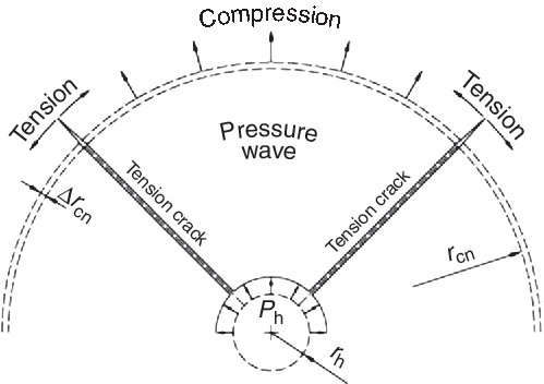
Fig. 5. Schematic depiction of radial tension fractures formation (after Torbica & Lapčević, Reference Torbica and Lapčević2018).
Within the innermost circle, the rock is crushed by deformation of the rock’s fabric (Whittaker et al. Reference Whittaker, Singh and Sun1992; Banadaki & Mohanty, Reference Banadaki and Mohanty2012). This involves an expansion in volume, and the remaining energy is spent creating tensile stress around the full circle of the area of immediate impact (zone 1). Added to this is the pressure caused by gases released by the explosive (Kutter & Fairhurst, Reference Kutter and Fairhurst1971). The tangential component of the stress wave is coincidental to the shock wave, and it is believed that most fracture propagation velocities are much less than the velocity of the shock wave (Guerra et al. Reference Guerra, Petr and Griffiths2013). At the distance r cn from the explosive charge, compressive stress of the rock in the radial direction is defined as
 $${\sigma _{{\rm{rc}}}} = {P_{\rm{h}}}{\rm{}}{{{r_{\rm{h}}}} \over {{r_{{\rm{cn}}}}}},$$
where σ rc is the radial compressive stress, P h is the borehole pressure, r h is the borehole radius and r cn is the crack zone radius (Torbica & Lapčević, Reference Torbica and Lapčević2014).
Torbica & Lapčević (Reference Torbica and Lapčević2018) conclude that the ratio between compressive strain and tensile strain is the same as the ratio between total strain energy (absorbed plus recoverable) and recoverable strain energy. They also note that the strain in the direction of the pressure wave propagation (compression) is numerically equal to the strain in the plane of the wave front (tension).
4. Discussion and conclusion
The origin of the rock markings described here from Dong Men Yu Island in Fujian Province is thus identified as compressive and tensile stresses occasioned to granite blocks through major impacts. The release of massive kinetic energy has created natural patterns of rock markings that can easily be perceived as anthropogenic, especially as resembling large ‘rising Sun’ symbols. Their central part represents the sheared or crushed zone 1 caused by a shock wave of compressive force, while the ‘rays’ were caused by tensile stresses triggered by the first process. The visual properties of these rock markings became emphasized by selective erosion with time, affecting the impacted rock surfaces much more than those not modified by the impact. Among the numerous types of natural rock markings that have been mistaken for petroglyphs, the compressive–tensile rock markings described here belong to the category GP2, naturally enhanced inherent markings (Bednarik, Reference Bednarik1994). After impact they were inherent in the rock, but their high visibility is largely the result of weathering and granular exfoliation. It is considered likely that these essentially tribological phenomena (Bednarik, Reference Bednarik2019) are not limited to granitic rocks, but can also be found on various other rock types.


