


1. Introduction
NW Turkey, comprising the Western Pontides, is one of the key localities to study the tectonic evolution of the Palaeo- and Neotethyan oceans. It is a tectonic mosaic of, and was formed by the amalgamation of, several zones that comprise several continental slices and subduction-accretion complexes, including the Strandja Massif, the İstanbul Zone and the Sakarya Zone (Figs 1, 2).

Figure 1. Tectonic units of Turkey showing the location of the İstanbul Zone (from Okay & Tüysüz, Reference Okay, Tüysüz, Durand, Jolivet, Horvath and Seranne1999).

Figure 2. Simplified geological map of the İstanbul Zone showing the location of the Almacık area (from Yiğitbaş et al. Reference Yİğİtbaş, Kerrich, Yılmaz, Elmas and Xie2004).
The Strandja Massif in the west is the eastern continuation of the Rhodope and Serbo-Macedonian massifs in the southern Balkans and consists of a Palaeozoic basement and a Triassic–Jurassic cover sequence. It is alternatively interpreted as part of a Cimmerian continent (Şengör, Reference Şengör1984; Yılmaz et al. Reference Yılmaz, Tüysüz, Yİğİtbaş, Genç, Şengör and Robinson1997) or a Variscan fragment (Okay et al. Reference Okay, Satır, Tüysüz, Akyüz and Chen2001). The eastern contact with the İstanbul Zone is buried beneath the Eocene sediments (Fig. 1) but is interpreted as a transform fault (Okay, Şengör & Görür, Reference Okay, Şengör and Görür1994) or a suture (Yılmaz et al. Reference Yılmaz, Tüysüz, Yİğİtbaş, Genç, Şengör and Robinson1997). The Palaeozoic basement is composed of high-grade quartzo-feldspathic gneisses, migmatites, micaschists, orthogneisses and rare amphibolites and is intruded by Early Permian (c. 271–257 Ma) granitoids. The leucocratic, biotite-muscovite and hornblende-biotite orthogneisses yielded c. 314–312 Ma Pb–Pb zircon ages; they are attributed to deformation and metamorphism during Late Carboniferous or Early Permian times (Okay et al. Reference Okay, Bozkurt, Satır, Yİğİtbaş, Crowley and Shang2008). The cover rocks comprise a Lower to Middle Triassic–Jurassic sedimentary sequence of metaconglomerate, metasandstone, phyllite, calc-phyllite and marble (Aydın, Reference Aydın1988; Okay et al. Reference Okay, Satır, Tüysüz, Akyüz and Chen2001; Natal'in, Sunal & Toraman, Reference Natal'in, Sunal, Toraman and Sklyarov2005; Sunal et al. Reference Sunal, Natal'in, Satır and Toraman2006, Reference Sunal, Satir, Natal'in and Toroman2008, Reference Sunal, Satır, Natal'in, Topuz and Vonderschmidt2011; Natal'in et al. Reference Natal'in, Sunal, Satır and Toraman2012). The massif has suffered from a second phase of metamorphism at greenschist-facies conditions during the Jurassic period. Recent Jurassic to Cretaceous mica ages (162.9 to 118.7 Ma) are attributed to this phase, but their significance is interpreted differently. 40Ar–39Ar mica ages range from 156.5 to 142.6 Ma and 136 to 118.7 Ma and are attributed to first mylonitic, then brittle deformation in the footwall of a detachment fault. In this model, the Strandja Massif is interpreted as a Late Jurassic – Early Cretaceous core complex (Elmas et al. Reference Elmas, Yılmaz, Yİğİtbaş and Ullrıch2011). Rb–Sr muscovite ages range from 162.9 ± 1.6 Ma to 149.1 ± 2.1 Ma and are attributed to a regional greenschist- to lower amphibolite-facies metamorphism where peak conditions occurred at c. 160 Ma. This event is attributed to N- to NE-vergent ductile shear zones and brittle thrusts during a N-vergent compressional deformation coupled with exhumation (Sunal et al. Reference Sunal, Satır, Natal'in, Topuz and Vonderschmidt2011). The massif is unconformably overlain by Mid Cretaceous (Cenomanian) shallow-marine sandstones.
The İstanbul Zone is a 400 km long and 55 km wide continental fragment along the southern margin of the Black Sea (Fig. 2) and is largely characterized by a thick (> 3000 m) little-deformed and largely unmetamorphosed passive-margin-type Palaeozoic sedimentary sequence (known as the İstanbul Palaeozoic), extending virtually unbroken from the Ordovician to the Carboniferous (e.g. Abdüsselamoğlu, Reference Abdüsselamoǧlu1959; Haas, Reference Haas1968; Yılmaz et al. Reference Yılmaz, Genç, Yİğİtbaş, Bozcu and Yılmaz1995, Reference Yılmaz, Tüysüz, Yİğİtbaş, Genç, Şengör and Robinson1997; Görür et al. Reference Görür, Monod, Okay, Şengör, Tüysüz, Yİğİtbaş, Sakınç and Akkök1997; Dean et al. Reference Dean, Monod, Rickards, Demir and Bultynck2000; Okay et al. Reference Okay, Zack, Okay and Barth2011; Ustaömer et al. Reference Ustaömer, Ustaömer, Gerdes and Zulauf2011; Özgül, Reference Özgül2012 and references therein). Outcrops occur in the Kocaeli Peninsula (east of İstanbul), Armutlu Peninsula, Çamdağ, Almacık, Sünnice Mountains and Karadere area (Abdüsselamoğlu, Reference Abdüsselamoǧlu1959; Akartuna, Reference Akartuna1968; Arpat et al. Reference Arpat, Tütüncü, Uysal and Göğer1978; Yılmaz, Gözübol & Tüysüz, Reference Yılmaz, Gözübol, Tüysüz, Işıkara and Vogel1982, O. Cerit, unpub. Ph.D. thesis, Hacettepe Univ., 1990; Yılmaz et al. Reference Yılmaz, Genç, Yİğİtbaş, Bozcu and Yılmaz1995; Ustaömer, Reference Ustaömer1999; Yiğitbaş, Elmas & Yılmaz, Reference Yİğİtbaş, Elmas and Yılmaz1999; Göncüoğlu et al. Reference Göncüoğlu, Gürsu, Tekin and Köksal2008) (Fig. 2). The Palaeozoic sequence commences with Ordovician basal conglomerates and sandstones unconformably overlying crystalline basement (e.g. Yılmaz, Gözübol & Tüysüz, Reference Yılmaz, Gözübol, Tüysüz, Işıkara and Vogel1982; Ustaömer & Rogers, Reference Ustaömer and Rogers1999; Yiğitbaş, Elmas & Yılmaz, Reference Yİğİtbaş, Elmas and Yılmaz1999; Yiğitbaş et al. Reference Yİğİtbaş, Kerrich, Yılmaz, Elmas and Xie2004; Ustaömer, Mundil & Renne, Reference Ustaömer, Mundil and Renne2005; Okay, Satır & Siebel, 2006), exposed on the Armutlu Peninsula, and in the Sünnice Massif and Karadere area (Fig. 2). (i) In the Armutlu Peninsula, the basement is composed of a high-grade amphibolite-gneiss sequence and intrusive Cadomian and Mid Ordovician granitic rocks; granites suggest two periods of plutonism during the latest Proterozoic (570 Ma) and Ordovician (460 Ma) (Okay et al. Reference Okay, Bozkurt, Satır, Yİğİtbaş, Crowley and Shang2008). (ii) In the Sünnice Massif area, the basement is composed of a high-grade (amphibolite facies) metamorphic sequence dominated by migmatitic quartzo-feldspathic gneisses (Demirci paragneisses; Yiğitbaş, Winchester & Ottley, Reference Yİğİtbaş, Winchester and Ottley2008), and a sequence of low-grade (greenschist facies) metavolcanic rocks (Yellice lavas: meta-andesites and minor meta-rhyolites) (Ustaömer & Rogers, Reference Ustaömer and Rogers1999; Yiğitbaş et al. Reference Yİğİtbaş, Kerrich, Yılmaz, Elmas and Xie2004). They are intruded by voluminous arc-related calc-alkaline granitoids (Dirgine granite; O. Cerit, unpub. Ph.D. thesis, Hacettepe Univ., 1990; Erendil et al. 1991, Maden Tetkik ve Arama (MTA) unpub. report no. 45529; Ustaömer & Rogers, Reference Ustaömer and Rogers1999; Yiğitbaş, Elmas & Yılmaz, Reference Yİğİtbaş, Elmas and Yılmaz1999; Yiğitbaş et al. Reference Yİğİtbaş, Kerrich, Yılmaz, Elmas and Xie2004), which have yielded Ediacaran ages (565 ± 2 and 576 ± 6 Ma; Ustaömer, Mundil & Renne, Reference Ustaömer, Mundil and Renne2005). The amphibolites of the Çele mafic complex, previously considered as the part of basement, are shown to be much younger, with Late Permian to Triassic U–Pb zircon ages (Bozkurt, Winchester & Satır, unpub. data). (iii) The basement in the Karadere area consists of high-grade metasediments and metagranitoids. The metagranites suggest a continental arc setting and yielded zircon ages between 590 and 560 Ma (Chen et al. Reference Chen, Siebel, Satır, Terzİoğlu and Saka2002). The Rb–Sr biotite ages are 548–545 Ma (Chen et al. Reference Chen, Siebel, Satır, Terzİoğlu and Saka2002). The İstanbul Palaeozoic was deformed during a N- to NE-vergent Carboniferous event (Zapcı, Akyüz & Sunal, Reference Zapcı, Akyüz and Sunal2003) and was intruded by a Permian (c. 255 Ma) granitoid (Yılmaz, Reference Yılmaz1977). A Triassic continental to marginal marine sedimentary sequence covers the Palaeozoic succession with a marked regional unconformity. The eastern boundary of the İstanbul Zone with the Triassic–Early Jurassic Palaeotethyan oceanic assemblages (Ballıdağ-Küre unit) in the Central Pontides is a thrust (Ustaömer & Robertson, Reference Ustaömer and Robertson1993, Reference Ustaömer and Robertson1994) while the southern boundary with the Sakarya Zone is at present marked by the active segments of the North Anatolian Fault Zone (Fig. 2). New zircon age data from both the basement and Palaeozoic sediments of the İstanbul Zone suggest that it is a peri-Gondwanan zone comparable to Avalonia (Bozkurt et al. Reference Bozkurt, Winchester, Yİğİtbaş and Ottley2008; Okay et al. Reference Okay, Bozkurt, Satır, Yİğİtbaş, Crowley and Shang2008, Reference Okay, Zack, Okay and Barth2011) or likewise originating close to Amazonia (Ustaömer et al. Reference Ustaömer, Ustaömer, Gerdes and Zulauf2011). The İstanbul Zone was later detached from Avalonia, and then migrated to its present location by left-lateral strike-slip faults (Winchester et al. Reference Winchester, Pharaoh, Verniers, Ioane, Seghedi, Stephenson and Gee2006; Bozkurt et al. Reference Bozkurt, Winchester, Yİğİtbaş and Ottley2008; Okay et al. Reference Okay, Zack, Okay and Barth2011).
The Ballıdağ-Küre unit is a pre-Malm (Triassic–Early Jurassic) subduction-accretion complex, consisting of siliciclastic sediments, dismembered ophiolite, metabasites, mélange and magmatic arc sequences (Ustaömer & Robertson, Reference Ustaömer and Robertson1994, Reference Ustaömer, Robertson and Robinson1997, Reference Ustaömer and Robertson1999). The unit is cut by granitoids of Mid Jurassic age (Yılmaz, Reference Yılmaz1980; Boztuğ et al. Reference Boztuğ, Debon, Le Fort and Yılmaz1984; Aydın et al. Reference Aydın, Şahİntürk, Serdar, Özçelİk, Akarsu, Güngör, Çokuğraş and Kasar1985, Reference Aydın, Demİr, Özçelİk, Terzİoğlu, Satır, Erler, Ercan, Bingöl and Örçen1995; Yılmaz & Boztuğ, Reference Yılmaz and Boztuğ1986). It is interpreted as a remnant of a back-arc basin (Küre), opened in Early Triassic time above a northward-dipping Palaeotethyan subduction zone and then closed during the Late Jurassic southward subduction of the Palaeotethyan Ocean beneath the Sakarya Zone (Ustaömer & Robertson, Reference Ustaömer and Robertson1994, Reference Ustaömer, Robertson and Robinson1997, Reference Ustaömer and Robertson1999; Kozur et al. Reference Kozur, Aydın, Demür, Yakar, Göncüoğlu and Kuru2000; Stampfli, Reference Stampfli, Bozkurt, Winchester and Piper2000; Stampfli & Borel, Reference Stampfli and Borel2002; Robertson et al. Reference Robertson, Ustaömer, Pickett, Collins, Andrew and Dixon2004). The Ballıdağ-Küre unit was thrust onto the rocks of the İstanbul Zone before Late Jurassic time, as Upper Jurassic rocks form common cover.
The Sakarya Zone is an elongate crustal ribbon extending from the Biga Peninsula in the west to the Eastern Pontides in the east (Fig. 1). It is characterized by a crystalline basement and an unconformably overlying Lower Jurassic – Upper Cretaceous passive margin sedimentary sequence. The pre-Liassic crystalline basement comprises: (i) A high-grade (amphibolite to granulite facies) metamorphic sequence of gneiss, amphibolite, marble and scarce metaperidotite; the Variscan metamorphism is dated at 330–310 Ma (Carboniferous zircon and monazite ages; Topuz et al. Reference Topuz, Altherr, Kalt, Satır, Werner and Schwartz2004, Reference Topuz, Altherr, Schwartz, Dokuz and Meyer2007; Okay, Satır & Siebel, 2006; Nzegge & Satır, Reference Nzegge and Satır2007). The high-grade metamorphic rocks occur in the Kazdağ, Devrekani, Pulur and Gümüşhane massifs and are intruded by Carboniferous granites (e.g. Topuz et al. Reference Topuz, Altherr, Siebel, Schwarz, Zack, Hasözbek, Barth, Satır and Şen2010; Ustaömer, Ustaömer & Robertson, Reference Ustaömer, Ustaömer and Robertson2012). (ii) A Permo-Triassic low-grade Palaeotethyan subduction-accretion complex, known as the Karakaya Complex, with Upper Triassic blueschists and eclogites (Okay & Monié, Reference Okay and Monié1997; Okay, Monod & Monié, Reference Okay, Monod and Monié2002). It is composed of metabasite with lesser amounts of marble and phyllite, accreted to the basement rocks during latest Triassic time (Okay & Monié, Reference Okay and Monié1997; Okay, Monod & Monié, Reference Okay, Monod and Monié2002; Okay & Göncüoğlu, Reference Okay and Göncüoğlu2004; Topuz et al. Reference Topuz, Altherr, Kalt, Satır, Werner and Schwartz2004). These rocks are unconformably overlain by a Lower Jurassic – Lower Cretaceous transgressive sequence. Several different models have been proposed for the origin and evolution of the Karakaya Complex and the readers are referred to recent literature for further reading (e.g. Okay & Göncüoğlu, Reference Okay and Göncüoğlu2004; Robertson & Ustaömer, Reference Robertson and Ustaömer2012; Sayıt & Göncüoğlu, Reference Sayıt and Göncüoğlu2012).
The contact between the İstanbul Zone in the north and the Sakarya Zone in the south is interpreted as an ophiolitic suture zone, termed the Intra-Pontide Suture (Şengör, Yılmaz & Ketin, Reference Şengör, Yılmaz and Ketin1980; Şengör & Yılmaz, Reference Şengör and Yılmaz1981). It records the closure of a discrete Early Jurassic to Late Cretaceous – Early Tertiary Intra-Pontide oceanic basin, one of the branches of the northern Neotethys, which existed along the southern margin of Eurasia in the Pontides between the Rhodope–Pontide fragment in the north and the Sakarya Continent in the south (Şengör, Yılmaz & Ketin, Reference Şengör, Yılmaz and Ketin1980; Şengör & Yılmaz, Reference Şengör and Yılmaz1981). Because the North Anatolian Fault Zone was superimposed on the supposed suture zone and there were no ages from the metamorphic and meta-ophiolitic rocks, the origin, age, evolution and even the existence of the Intra-Pontide Ocean and its suture have been debated for decades. The proposed models fall into three groups. (1) The first model argued that several branches of the northern Neotethys existed and that the Mesozoic Intra-Pontide oceanic basin was one of them. It formed and later closed between the Eurasian continent (İstanbul Zone?) to the north and a microcontinent (Sakarya Continent) to the south within the Western Pontides (e.g. Şengör & Yılmaz, Reference Şengör and Yılmaz1981; Göncüoğlu & Erendil, Reference Göncüoğlu and Erendil1990; Yılmaz, Reference Yılmaz1990; Yılmaz et al. Reference Yılmaz, Genç, Yİğİtbaş, Bozcu and Yılmaz1995, Reference Yılmaz, Tüysüz, Yİğİtbaş, Genç, Şengör and Robinson1997; Okay et al. Reference Okay, Satır, Maluski, Siyako, Monie, Metzger, Akyüz, Yin and Harrison1996, Reference Okay, Satır, Siebel, Gee and Stephenson2006; Göncüoğlu et al. Reference Göncüoğlu, Gürsu, Tekin and Köksal2008). There is, however, no consensus on the timing of opening (Early Jurassic: Şengör, Yılmaz & Ketin, Reference Şengör, Yılmaz and Ketin1980; Şengör & Yılmaz, Reference Şengör and Yılmaz1981; Late Bathonian: Göncüoğlu et al. Reference Göncüoğlu, Gürsu, Tekin and Köksal2008; Triassic: Robertson & Ustaömer, Reference Robertson and Ustaömer2004; Early Triassic: Akbayram, Okay & Satır, Reference Akbayram, Okay and Satır2012) and closure (juxtaposition of the İstanbul Zone and Sakarya Zone) (Early Eocene – Oligocene: Görür & Okay, Reference Görür and Okay1996; Early Eocene: Okay, Şengör & Görür, Reference Okay, Şengör and Görür1994; Paleocene–Lutetian: Şengör & Yılmaz, Reference Şengör and Yılmaz1981; middle Late Cretaceous: Göncüoğlu et al. Reference Göncüoğlu, Gürsu, Tekin and Köksal2008; pre-Santonian: Özcan et al. Reference Özcan, Okay, Özcan, Hakyemez and Özkan-Altıner2012; Coniacian–Santonian: Yılmaz et al. Reference Yılmaz, Genç, Yİğİtbaş, Bozcu and Yılmaz1995; Elmas & Yiğitbaş Reference Elmas and Yİğİtbaş2001, Reference Elmas and Yİğİtbaş2005; Turonian: Robertson & Ustaömer, Reference Robertson and Ustaömer2004; Cenomanian: Tüysüz, Reference Tüysüz1999; pre-Cenomanian: Göncüoğlu & Erendil, Reference Göncüoğlu and Erendil1990; Early Cretaceous: Akbayram, Okay & Satır, Reference Akbayram, Okay and Satır2012) of the ocean. (2) The second model argues that there was only a single branch of the northern Neotethys present and that the late Mesozoic (?) ophiolitic units in the region formed during the closure of the İzmir–Ankara–Erzincan Neotethyan Ocean, then were emplaced into their present position by left-lateral strike-slip faulting (Western Pontide Fault) during Late Cretaceous time (Elmas & Yiğitbaş, Reference Elmas and Yİğİtbaş2001). This structure was interpreted as a transform fault in the İzmir–Ankara–Erzincan Neotethyan Ocean (Elmas & Yiğitbaş, Reference Elmas and Yİğİtbaş2001). These authors termed the contact zone between the İstanbul and Sakarya zones the Armutlu–Ovacık Zone. (3) The third model denies the existence of any Neotethyan (i.e. mainly Mesozoic) oceanic basin(s) in NW Turkey (e.g. Kaya, Reference Kaya1977; Kaya & Kozur, Reference Kaya and Kozur1987) and argues for Permo-Triassic and Late Jurassic – Early Cretaceous rifting events without seafloor spreading. This model considers supposedly ophiolitic rocks in the suture zone to be Precambrian in age.
The high-grade amphibolitic rocks in the Armutlu Peninsula and Almacık Mountains and a sedimentary mélange (Arkotdağ mélange: Tokay, Reference Tokay1973 or Abant complex: Yılmaz, Gözübol & Tüysüz, Reference Yılmaz, Gözübol, Tüysüz, Işıkara and Vogel1982) further to the east of Bolu are commonly used as supportive evidence for the existence of an Intra-Pontide Ocean and its suture. In the Armutlu Peninsula, metagranitoids intruded an amphibolite-gneiss sequence and yielded latest Proterozoic (c. 570 Ma) U–Pb zircon laser ablation multicollector inductively coupled plasma mass spectrometry (LA-MC-ICP-MS) and Mid to Late Ordovician (460 Ma) Pb–Pb zircon evaporation ages (Okay et al. Reference Okay, Bozkurt, Satır, Yİğİtbaş, Crowley and Shang2008). Aral Okay and his co-authors (Reference Okay2008) stated that ‘the new isotopic data indicate unambiguously that the high-grade amphibolite-gneiss sequence in the Armutlu Peninsula is not of Cretaceous age but forms part of the late Proterozoic – Early Palaeozoic basement of the İstanbul terrane, as initially suggested by Kaya (Reference Kaya1977) and Yiğitbaş et al. (Reference Yİğİtbaş, Elmas and Yılmaz1999, Reference Yİğİtbaş, Kerrich, Yılmaz, Elmas and Xie2004)’. It is also suggested that the Intra-Pontide Suture can be compared to the Rheic Suture (Stampfli & Borel, Reference Stampfli and Borel2002; Winchester & the PACE TMR Network Team, Reference Winchester2002; Okay et al. Reference Okay, Bozkurt, Satır, Yİğİtbaş, Crowley and Shang2008).
The Arkotdağ mélange is a dismembered Upper Cretaceous sedimentary mélange with blocks of pelagic limestone, radiolarian chert, pillow basalt, gabbro, clastic sediments, rare sheared serpentinite and ultramafic blocks within an intensely deformed, slightly metamorphosed matrix of debris flow deposits (Tokay, Reference Tokay1973; Yılmaz, Gözübol & Tüysüz, Reference Yılmaz, Gözübol, Tüysüz, Işıkara and Vogel1982). Göncüoğlu et al. (Reference Göncüoğlu, Gürsu, Tekin and Köksal2008) studied a part of this tectonically disrupted complex and reported a fossil assemblage from a single silicified mudstone sample from a block with alternating sediments and volcanic rocks (see their Fig. 3). Radiolaria yielded a late Kimmeridgian to early Tithonian age. The authors then argued, based on new data and previous fossil finds in the Çetmi mélange of the Biga Peninsula, that the Intra-Pontide Ocean existed at least between Bathonian and Santonian times. However, it is not clear if the Arkotdağ mélange is part of a subduction-accretion complex of the Ankara–Erzincan Neotethyan Ocean, as are Upper Cretaceous high pressure–low temperate (HP–LT) rocks in the Central Pontides (cf. Okay et al. Reference Okay, Tüysüz, Satır, Özkan-Altıner, Altıner, Sherlock and Eren2006).

Figure 3. Simplified geological map showing the location of the Almacık complex (adapted from the 1:5000 scale geological map of Turkey, published by MTA). The age of the Almacık complex ultramafic and mafic rocks in the Almacık Mountains is shown as Late Cretaceous as in the original map but they are proven to be much older (Permo-Triassic), in the present study.
The high-grade ultramafic-mafic complex in the Almacık Mountains has long been based on inferences and regional correlations, considered of Cretaceous age, and is attributed to the Intra-Pontide Suture (see next Section). The region therefore forms a key locality to test alternative models on the existence and evolution of the Mesozoic Intra-Pontide Ocean. In this paper, we report U–Pb zircon age data from rocks of the Almacık complex and discuss their tectonic significance. The paper also aims to test a possible similarity between the Almacık and Çele complexes and discuss their tectonic significance.
2. Almacık complex
The Almacık complex is a tectonically isolated block of mafic and ultramafic rocks set within the seismically active North Anatolian Fault Zone in NW Turkey. All its exposed contacts with adjacent rocks are faulted. The dextral transcurrent North Anatolian Fault Zone (Figs 2, 3) bounds the southern margin of the İstanbul Zone: it is exploiting the weakness of, and reactivating displacement along, the Triassic suture zone marking the contact between the İstanbul Zone in the north and the Sakarya Continent to the south (e.g. Elmas & Yiğitbaş, Reference Elmas and Yİğİtbaş2001). Close to its southern margin, the basement of the İstanbul Zone is exposed as inliers of Proterozoic rocks, unconformably overlain by basal Ordovician conglomerates and sandstones (the largest inlier being the Sünnice Massif, north of Bolu; e.g. Ustaömer, Reference Ustaömer1999; Ustaömer & Rogers, Reference Ustaömer and Rogers1999; Yiğitbaş, Elmas & Yılmaz, Reference Yİğİtbaş, Elmas and Yılmaz1999; Yiğitbaş, Winchester & Ottley, Reference Yİğİtbaş, Winchester and Ottley2008) (Fig. 1). This is in tectonic contact with the underlying Permo-Triassic Çele mafic complex (Bozkurt, Winchester & Satır, unpub. data) in the Sünnice (Bolu) Mountains. To the southwest, in fault-bounded blocks within the North Anatolian Fault Zone, the structurally highest parts of a mafic-ultramafic complex exposed on the southern side of the Almacık range (Almacık complex) resemble the Çele mafic complex in the Sünnice (Bolu) Massif. Because of this apparent similarity, the rocks from the Almacık complex were sampled for geochemical analysis for comparison with those collected from the Sünnice area, interpreted as a meta-ophiolite (Yılmaz et al. Reference Yılmaz, Genç, Yİğİtbaş, Bozcu and Yılmaz1995; Yiğitbaş, Elmas & Yılmaz, Reference Yİğİtbaş, Elmas and Yılmaz1999; Yiğitbaş et al. Reference Yİğİtbaş, Kerrich, Yılmaz, Elmas and Xie2004), and termed by previous authors as the Çele meta-ophiolite (Yiğitbaş, Elmas & Yılmaz, Reference Yİğİtbaş, Elmas and Yılmaz1999), but most recently considered to be basal crust to an active continental margin (ACM) and thus renamed the Çele mafic complex (Bozkurt, Winchester & Satır, unpub. data).
The Almacık complex is mainly composed of ultramafic and mafic rocks where all lithologies display tectonic contact relationships in an imbricate structure. The most characteristic lithologies include harzburgite, websteritic pyroxenite, locally carbonatized/listwaenitic harzburgite (local magnesite and some talc-magnesite occurrences), serpentinized harzburgite and websterite bands, serpentine-talc-epidote-spinel serpentinite, metagabbroic hornblende gneisses, isoclinally folded foliated amphibolites/metabasic rocks in the form of hornblende-plagioclase-quartz gneisses and hornblende-clinopyroxene-plagioclase gneisses and intruding plagiogranitic sheets. These rocks have experienced amphibolite-facies metamorphism (at c. 600–720°C and 5 kb; Çelik et al. Reference Çelİk, Gürer, Aldanmaz, Spell and Öz2009) and subsequent greenschist-facies retrogression. The complex is in tectonic contact (thrust/reverse fault or strike-slip fault segments of the North Anatolian Fault Zone) with several different lithologies with ages ranging from Ordovician to Eocene (Fig. 3).
The ultramafic-mafic rocks were long considered to be Late Cretaceous in age and were interpreted as the remnants of, and therefore the evidence for the existence of, a Mesozoic Intra-Pontide oceanic basin, a branch of the northern Neotethys (e.g. Şengör & Yılmaz, Reference Şengör and Yılmaz1981; Yılmaz, Gözübol & Tüysüz, Reference Yılmaz, Gözübol, Tüysüz, Işıkara and Vogel1982; Yılmaz et al. Reference Yılmaz, Genç, Yİğİtbaş, Bozcu and Yılmaz1995; Robertson & Ustaömer, Reference Robertson and Ustaömer2004; Genç & Tüysüz, Reference Genç and Tüysüz2010). But as others claimed that these rocks may well be Neoproterozoic (Robertson & Ustaömer, Reference Robertson and Ustaömer2004), Precambrian (Yiğitbaş, Elmas & Yılmaz, Reference Yİğİtbaş, Elmas and Yılmaz1999; Yiğitbaş et al. Reference Yİğİtbaş, Kerrich, Yılmaz, Elmas and Xie2004; Elmas & Yiğitbaş, Reference Elmas and Yİğİtbaş2005) or Palaeozoic (Abdüsselamoğlu, Reference Abdüsselamoǧlu1959; Gözübol, Reference Gözübol1980), others argued for the existence of an Intra-Pontide Ocean. Although the tectonic significance of the Almacık complex plays a key role in the Alpine history of the eastern Mediterranean area, the age assignments on the existing models were based largely on lithological and regional correlations and there has been no dating on these rocks. This paper therefore provides the first geochronological data, discusses their tectonic significance and aims to comment on the existence and evolution of the Mesozoic Intra-Pontide Ocean.
The Almacık complex is exceptionally well exposed for several kilometres along a recently constructed E–W section of the Mudurnu–Düzce highway and, owing to consistently steep dips and a local N–S strike, this section exposes a revealingly deep transect through the complex (Fig. 4).

Figure 4. Map showing the setting and field relationships of the varied mafic and ultramafic rocks that make up the Almacık Massif. Locations of numbered samples along the principal road section are given.
3. Petrography
3.a. Macroscopic and microscopic appearance
Samples from the Almacık road section on the Mudurnu–Düzce highway display a great variety of textures and mineral assemblages. Sampling was greatly assisted by the blasting of the new road traversing the mafic-ultramafic complex from east to west, laying bare fresh new exposures in an almost continuous section. Throughout the section foliation dips tend to be steep, with a dominant north-northeasterly strike direction. Towards the west end of this section, ultramafic rocks become more abundant, suggesting that lower structural levels within the complex tend to occur in the west. From east to west, therefore, the road section appears to descend to progressively lower structural levels, although the presence of at least three distinct bands of ultramafic rocks with high strain zones on their western margins suggests that tectonic repetition as a result of ductile thrusting has also occurred (Fig. 2).
3.b. Ultramafic rocks of the Almacık complex
The main band of ultramafic rocks, which is at least 1 km thick, exposed at the western end of the Almacık road-cutting, consists almost entirely of dark greenish harzburgite, which only shows minor evidence of hydration in the form of serpentinite and talc veining and local carbonatization, producing listwaenites containing pale magnesite. Away from the veining, and because of the relative lack of hydration, these harzburgites have suffered relatively little other chemical change during metamorphism and few secondary minerals are present, so the rock still contains dominant fresh olivine, with subordinate orthopyroxene and dark greenish spinel (Fig. 5a). A few grains of clinopyroxene are also present in some samples.

Figure 5. (a) Thin-section (cross polarized light) of harzburgite from the Almacık road section; (b) websterite outcrop; pen is 15 cm long; (c) thin-section (cross polarized light) of websterite consisting of a granoblastic intergrowth of orthopyroxene and clinopyroxene from the Almacık road section. The field of view of (a) and (c) is 1.3 mm.
By contrast, the thinner ultramafic band approximately 1 km further to the east (Fig. 4), which is less than 600 m wide, comprises rock that, although it has been extensively hydrated to a serpentine-talc-epidote-spinel serpentinite, has preserved textures which suggest that it too was originally harzburgitic.
The third, and easternmost ultramafic band, situated 1 km further east (Fig. 4), is a very distinctive green websteritic pyroxenite up to 1 km thick, devoid of olivine, but containing brown orthopyroxene and bright green clinopyroxene, probably chrome diopside (Fig. 5b, c). Usually medium grained, these pyroxenites also contain a coarse-grained variant, with crystals that can exceed 4 cm across. This rock is well preserved and shows relatively little metamorphic replacement by amphibole, suggesting that very little subsequent hydration occurred.
3.c. Mafic rocks
Varieties of hornblende gneiss of mostly mafic (gabbroic to gabbroic diorite) composition are the dominant lithologies, but display considerable textural variation. There is no textural evidence to suggest the former presence of deformed pillow lavas: it therefore seems that, if this complex had been ophiolitic, like so many others in Turkey, its upper levels are not preserved. Medium- to fine-grained hornblende gneiss can locally have sharp contacts with coarser grained metagabbroic hornblende gneiss: the contrast in grain size may reflect grain-size variations in the igneous protolith, and hence the hornblende gneisses may include both gabbroic and former dyke (strictly metadoleritic) complexes. Variations also occur in mineral proportions: there are paler amphibolites containing a higher ratio of plagioclase to hornblende, and plagiogranitic sheets; the latter are locally garnetiferous and distinguished by intense deformation from pervasive later silicic intrusions of likely Jurassic age.
Between the main bands of ultramafic rocks are metabasic rocks, which petrologically resemble each other, but which can be separated into different suites chemically (see Section 4). In the west, between the harzburgitic bands, metabasic rocks are typically hornblende-plagioclase-quartz gneisses, with accessory epidote and titanite, although in some the amphibole is unusually pale and may be actinolitic, occurring in association with abundant and well-developed crystals of clinozoisite. East of the websterite band, similar hornblende gneisses occur; in some of these the plagioclase is typically andesine and there are locally abundant grains of pyroxene displaying a symplectitic texture. These pyroxenes are not necessarily relict pyroxenes from the original mafic rocks: they are more likely to be products of metamorphism and to indicate that the complex underwent high amphibolite-facies metamorphism. Associated plagiogranite is composed dominantly of quartz and oligoclase, with very subordinate brown biotite, epidote and muscovite. K-feldspar appears to be absent.
By contrast, between the serpentinized harzburgite and websterite bands, the metabasic rocks seem in part to include veined and degraded pyroxenite, although their chemistry (see Section 4) nonetheless tends to be basic, rather than ultrabasic.
Further east, around the small valley where a resthouse has recently been built, ‘metabasites’ tend to be paler. These rocks, which we term here the ‘Resthouse metabasites’, are also chemically distinctive (see Section 4), and range in composition from basic to intermediate. They consist of hornblende-clinopyroxene-plagioclase gneisses, with scattered blades of secondary biotite, chlorite and muscovite betraying the presence of a late greenschist-facies overprint, while more evolved rocks, of broadly dioritic composition, tend to be dominated by abundant andesine, with subordinate hornblende, biotite and accessory ilmenite and titanite. Many contain orange-red garnets, occurring as porphyroblasts up to 1 cm across. Secondary chloritization again suggests that, following the amphibolite-facies metamorphism, these rocks were subjected to a superficial greenschist-facies retrogression. Included in the Resthouse metabasites are rocks that are texturally metagabbroic or pegmatitic, with individual hornblende crystals growing up to 8 cm in length. Garnet-bearing and strongly deformed plagiogranites are most abundant in this suite, and form a significant proportion of the rock.
The eastern part of the section consists entirely of more uniform hornblende-plagioclase-bearing mafic gneisses. These appear to form a distinct suite from the Resthouse metabasites, from which they are separated by a zone of sheared and mylonitized basic gneisses up to 100 m broad, showing that the contact is tectonic.
Overall, there appears to be a gradual increase in metamorphic grade towards the west, with amphibolite-facies hornblende gneisses grading progressively westwards into pyroxene granulites, in which the clinopyroxenes display symplectitic textures and have only been partially hydrated to hornblende. However, the westernmost mafic gneisses show a return to amphibolite-facies assemblages.
Prominent features along the entire road section are discordant mafic and granitoid dykes which cross-cut the foliation and show little evidence of amphibolite-facies metamorphism. Most of these probably relate to Jurassic or later magmatism in the area.
Within the complex, no textural evidence to suggest the former presence of either a sheeted dyke complex or pillowed basalts was observed; it is therefore concluded that the hornblende gneisses are likely to be almost entirely derived from the metamorphism of intrusive gabbros. Indeed, it is questionable whether the Almacık complex is uplifted ophiolite at all: in view of its high metamorphic grade it is possible that it represents a wedge of continental basement and subjacent mantle, and the absence of sheeted dykes or pillowed metabasalts is not simply a result of current erosion levels.
4. Chemical discrimination
Representative analyses are shown in Tables 1 and 2. Only the fresher samples were selected and they were also chosen as typical of the common lithologies present. The samples were crushed at the Middle East Technical University, Ankara, and analysed at Keele University, England, using an ARL 8420 X-ray fluorescence spectrometer, calibrated against both international and internal Keele standards of suitable composition (Floyd & Castillo, Reference Floyd, Castillo, Larson, Lancelot, Fisher and Winterer1992). Analytical methods and precision are detailed in Winchester, van Staal & Langton (Reference Winchester, van Staal and Langton1992). Selected samples were also analysed for rare earth elements (REEs) together with Cs, Hf, Sc, Ta and U, using a Perkin Elmer Sciex Elan 6000 ICP-MS at Durham University. More accurate determinations for Nb and Th in these samples were also obtained by this method and full analyses are provided in Tables 1 and 2. Data previously published (Yiğitbaş et al. Reference Yİğİtbaş, Kerrich, Yılmaz, Elmas and Xie2004) are also plotted on some of the succeeding diagrams, as the distribution of those samples complements those collected for this study.
Table 1. Full analyses of ultramafic rocks in the Almacık Complex

Abbreviations: wb – websterite; hzb – harzburgite; srphzb – serpentinized harzburgite; srptro – serpentinized troctolite.
Table 2. Full analyses of mafic rocks from the Almacık road section

Abbreviations: WMB – Western Metabasites; AkcMB – Akçalaan metabasite; RestMB – Resthouse metabasites; E-IAT – Eastern tholeiites; plaggr – plagiogranite.
4.a. Ultramafic rocks
The ultramafic rocks cropping out along the Almacık road-cutting fall into two clearly divided compositional sets (Table 1). Along this section the three bands of ultramafic rocks, thought to represent structural repetitions of the deepest part of the complex, show compositional characteristics that enable them to be chemically discriminated. Sampled for this study were harzburgites, serpentinized harzburgite and pyroxenites (websterites). Apart from predictably enhanced loss on ignition and Cl, and loss of CaO, Cr and V (Table 2), the composition of the band of serpentinized harzburgite is similar to that of the fresh harzburgite.
However, the websterites are compositionally distinct in having significantly less Fe2O3(total), MgO or Ni and enhanced SiO2, CaO, Cu, Sr, Y and V compared to the harzburgites. The harzburgites (including the serpentinized sample), characterized by very high MgO (> 35%) and Ni contents (Fig. 6a–c), plot entirely separately from the websterites, which have characteristically much higher CaO and lower MgO than the harzburgites. Both rock types have exceptionally high Cr. The websterites are characteristically much richer in REE than the harzburgites, and display a broadly level, slightly convex-up profile, lacking a significant Eu anomaly (Fig. 6d).

Figure 6. Discrimination diagrams distinguishing the chemistry of the various ultramafic rocks. (a) CaO–MgO; (b) Ni–Cr; (c) Al2O3–MgO; (d) Chondrite-normalized REE profiles.
4.b. Mafic to intermediate rocks
The distribution of the chemically distinguished metabasic and meta-ultrabasic rocks along the Almacık road section is shown, together with locations from which samples were obtained, on Figure 4. Chemical contrasts between the mafic rock types are less clearly defined than in the Çele mafic complex, as most of the rocks cluster on the margin between the tholeiitic and calc-alkaline fields, and so a ternary AFM diagram only reveals a rather indistinct calc-alkaline trend in these rocks (Fig. 7a). However, a few evolved metadioritic samples, associated with metagabbros, appear to have a calc-alkaline protolith. These rocks tend to occur around the most deeply incised valley descending from the Almacık mountains along the road section, and crop out close to the newly built resthouse in the valley. Referred to here as the Resthouse metabasites, they include the palest and most highly deformed, often garnetiferous gneisses, associated with the best-developed plagiogranites. In summary, it was possible to recognize four chemically distinguishable metabasite suites in the Almacık section, which we have termed: (i) Western metabasites, (ii) Akçalaan metabasites, (iii) Resthouse metabasites and (iv) Eastern tholeiites.

Figure 7. Discrimination diagrams showing the chemistry of the Almacık Massif mafic rocks. (a) AFM diagram (Irvine & Baragar, Reference Irvine and Baragar1971); (b) V–Ti diagram (Shervais, Reference Shervais1982); (c) V/Zr–Y/Sr diagram to distinguish the four different metabasite suites; (d) Cr/Fe2O3(total)–Sr/Y.
Other discrimination diagrams highlight minor compositional differences, notably variations in the proportions of Sr to Y and between Zr, TiO2, Fe2O3(total) and Cr (Fig. 7c, d), which seem to distinguish these suites of mafic gneisses and help separate them into geographically discrete blocks.
On a V–Ti plot (Fig. 7b) to distinguish island arc tholeiites from other oceanic basalts (Shervais, Reference Shervais1982), only the rocks from the easternmost end of the section (Eastern tholeiites), together with a single sample collected from the metabasites sandwiched between serpentinite and websterite close to Akçalaan Yurse village (termed here the Akçalaan metabasites) cluster consistently within the island arc tholeiite field (Fig. 7b). Eastern tholeiites, distinguished by a separate ornament on Figures 7 and 8, consistently form a discrete cluster of points. However, they share high Y/Sr with the mafic gneisses (Western metabasites) obtained from the western part of the section between the two harzburgite bands and from immediately east of the websterite band. These gneisses differ from the Eastern tholeiites principally because they contain lower V/Zr, and tend to form a separate trend on a Cr/Fe2O3(total)–Sr/Y diagram (Fig. 7c, d). The Resthouse metabasites can be distinguished from the other mafic suites by virtue of their lower Y/Sr on V/Zr–Y/Sr and Cr/Fe2O3(total)–Sr/Y diagrams (Fig. 7c, d).

Figure 8. (a) Chondrite-normalized rare earth and (b) N-MORB-normalized multi-element profiles for mafic rocks from the Almacık Massif.
A chondrite-normalized REE profile shows little distinction between the Eastern tholeiites and the Western metabasites. Both have broadly flat profiles, comparable enrichment and lack a Eu anomaly (Fig. 8a). By contrast, the sample from the Resthouse metabasites, obtained from pegmatitic hornblende gneiss near the resthouse, shows a sloping profile with light REE (LREE) enrichment, while the sample from the Akçalaan metabasite shows a marked LREE depletion.
Mid ocean ridge basalt (MORB)-normalized multi-element profiles typically show a spiked and sloping profile, which is most marked in the Resthouse (enriched) and Akçalaan (depleted) metabasite profiles (Fig. 8b). By contrast the other metabasite types show more subdued profiles, but still display Nb–Ta and Hf troughs, and Ba, Ce and Sm peaks. Only a single Western metabasite profile resembled those of the Çele calc-alkaline metabasites in lacking a Nb–Ta trough, and this lack of chemical comparability confirms that there is no exact match of metabasite types between the Çele mafic complex and the Almacık complex.
4.c. Comparisons between the Çele mafic complex and the Almacık complex
Comparisons between the Almacık complex and the Çele mafic complex show that, while there are similarities, the match is imprecise. For example, the Çele mafic complex does not expose the range of ultramafic rock types displayed in the Almacık section, although the analyses of its serpentinites vary between meta-harzburgite to meta-troctolite, suggesting a limited range of compositions. However, in both areas metabasites with an island arc tholeiite chemistry seem to occur at the highest structural level, and are underlain by suites of calc-alkaline metabasite. The distribution of the ultramafic rocks is potentially more problematic, but the locations of broad exposed shear zones along the Almacık road section shows that they are restricted to the basal portions of discrete thrust slices, and this segregation into different thrust slices might also explain their diversity, as they were probably juxtaposed after transport from different parts of the original complex.
5. Isotopic dating
Sampling was focused on the rocks exposed along the Almacık road section. Three samples (60-I, 61-I and 65) from locations 60 and 61 in the Resthouse metabasites and 65 in the Eastern tholeiites were selected from the plagiogranite dykes intruding the metabasic rocks (Figs 4, 9). It is possible that some zircons in the plagiogranites may be xenocrystic. In all samples, quartz and oligoclase form the main component minerals, while brown biotite, epidote and muscovite are subordinate grains. Details of mineral separation methods and analysis techniques are given in Okay et al. (Reference Okay, Bozkurt, Satır, Yİğİtbaş, Crowley and Shang2008).

Figure 9. Field views of the plagiogranite samples selected for age dating: (a) a general view of the plagiogranite dyke intruding into metabasic rocks southeast of the resthouse (sample 60-I; GPS coordinates: 3500329100°E and 4496843°N). The dyke is cut and displaced along a low-angle fault. It is deformed and metamorphosed and contains orange-red garnet crystals; (b) a close-up view of mesoscale folds deforming the plagiogranite dyke; (c, d) views of the location of samples 61-I (GPS coordinates: 350329048°E and 4496197°N) and 65 (GPS coordinates: 350329948°E and 4495644°N); they are dykes intruding the host rock metabasites; (e, f) close-up views of pegmatitic gabbros with megacrystic hornblende. The man is 166 cm tall; pencil and hammer are 15 and 33 cm long, respectively; and the diameter of the coin is 3 cm.
Several zircons were separated from sample 60-I; they occur as mostly small grains but are uniform in size (125–180 μm). The grains are clear idiomorphic, bi-pyramidal, medium–thick, stumpy or long and xenomorphic–prismatic to rounded, colourless, and almost free of inclusions. Thirteen grains analysed at Tübingen yielded a bimodal distribution of 207Pb–206Pb (2σ error) evaporation ages: (i) 253.6 ± 1.2 to 227.5 ± 2.3 Ma and (ii) 174.0 ± 3.4 to 166.7 ± 2.8 Ma (Table 3). Further studies of the older ages revealed four groups with mean ages of: (i) 253.6 ± 1.2 Ma, (ii) 242.7 ± 2.4 Ma (mean age), (iii) 235.7 ± 2.7 Ma (mean age) and (iv) 227.5 ± 2.3 Ma (Fig. 10a). The same sample was also analysed using LA-MC-ICP-MS at NIGL. Seventy zircon grains were analysed from this sample; the morphology of the big zircon grains suggests that they had metamorphic overgrowths. Because the zircon ‘cores’ were quite uranium depleted, a large laser spot size (50 microns) was used to get a decent signal. These ‘cores’ produced a U–Pb concordia age of 255.0 ± 1.3 Ma (Table 4, Fig. 10b). The ‘rims’ were much more uranium-rich and gave a U–Pb concordia age of 167.1 ± 2.1 Ma age (Fig. 10b). The important point to make here is that Pb–Pb single zircon evaporation and LA-MC-ICP-MS methods all yield similar ages of c. 250 Ma. A Rb–Sr biotite age was also obtained from this sample at Tübingen. The biotite contains 209.4 ppm Rb and 28.28 ppm Sr; the 87Sr/86Sr and 87Rb/86Sr ratios are 0.748335 ± 08 and 21.516, respectively. The biotite yields an age of 139 ± 2 Ma (Table 5). Garnets were separated from the granitic rock and, based on Sm–Nd (2σ) analysis at Tübingen, they yielded an age of 172 ± 41 Ma. The garnet data is consistent with the younger ages from the rims of the zircons. Although the error is too high in this data, it apparently shows garnet growth during metamorphism at c. 170 Ma.
Table 3. Zircon Pb evaporation data including radiogenic 207Pb/206Pb ratios and corresponding age data for samples 60-I, 61-I and 65

Table 4. LA-ICP-MS U–Pb zircon data and calculated apparent ages from sample 60-I

* Accuracy of U concentration is c. 20%.
† Isotope ratios are not common Pb corrected.
§ % discordance is measured as206Pb–238U age relative to 207Pb–235U age for all spots.
Table 5. Rb–Sr isotopic data and calculated age of biotite from sample 60-I

Sr-Standard – NBS 987; 87Sr/86Sr – 0.710250 ± 09.

Figure 10. (a, b) Isotopic dates obtained from a plagiogranite dyke emplaced into the Resthouse metabasites, sample 60-I: (a) diagram showing the distribution of Pb–Pb zircon evaporation ages; (b) U–Pb concordia plot showing zircon ages derived from LA-MC-ICP-MS analyses. (c, d) Isotopic dates obtained from a granite dyke in the Resthouse metabasites, sample 61-I: (c) diagram showing the distribution of Pb–Pb zircon evaporation ages; (d) histogram showing the distribution of 207Pb/206Pb ratios v. number of 207Pb/206Pb ratios derived from evaporation of zircons. (e) U–Pb discordia diagram of titanite grains from sample 60-I. (f) Diagram showing the distribution of Pb–Pb zircon evaporation ages from sample 65.
Nine zircons analysed from sample 61-I at Tübingen are mostly small grains, uniform in size (125–180 μm), clear, long and slender, xenomorphic to prismatic, colourless, and almost free of inclusions. The analysed zircon grains yielded a wide distribution of 207Pb–206Pb (2σ error) evaporation ages, varying between 256.0 ± 4.8 and 160.7 ± 4.2 Ma (Table 3). The age data fall into four groups: (i) 256 ± 4.8 Ma, (ii) 245.5 ± 1.1 Ma, (iii) 216.6 ± 4.1 Ma (mean age) and (iv) 162.9 ± 2.6 Ma (mean age) (Fig. 10c, d). Four titanite grains from the sample were also analysed at Tübingen (Table 6). The distribution of titanite ages along a discordia line shows a lower intercept of 163 ± 20 Ma (MSWD = 2.2) but with no useful upper intercept (Fig. 10e).
Table 6. Titanite U–Pb data from sample 61-I

All errors quoted are 2σ absolute uncertainties and refer to the last digit.
* radiogenic; grain size varies from 80–180 μm.
mg* – error in weight is estimated to be up to 10%.
Zircons from sample 65 are mostly small grains, uniform in size (125–180 μm), clear, medium, long and slender, prismatic, colourless, and almost free of inclusions. The zircon grains analysed at Tübingen yielded a wide distribution of 207Pb–206Pb (2σ error) evaporation ages, varying between 2442.6 ± 2.3 and 281.0 ± 3.1 Ma (Table 3; Fig. 10f).
As seen from the information above, reliable dates from the zircons yield Permo-Triassic dates of 255, 235 and 227 Ma, and Jurassic ages, ranging between 170 and 162 Ma. The c. 140 Ma biotite Rb–Sr ages reflect cooling below 400°C conditions. These we interpret as the Permian and Triassic ages of original rock formation (crystallization) and its subsequent Jurassic metamorphism and cooling, respectively. Plagiogranites (cf. Thayer, Reference Thayer1977) commonly occur as late intrusions into the gabbroic section of oceanic crust (e.g. Aumento, Reference Aumento1969; Casey, Reference Casey, Karson, Cannat, Miller and Elthon1997; Silantyev, Reference Silantyev1998; Dick et al. Reference Dick, Ozawa, Meyer, Niu, Robinson, Constantin, Hebert, Maeda, Natland, Hirth, Mackie, Natland, Dick, Miller and Von Herzen2002) and/or into the plutonic sections of most ophiolites (see Koepke et al. Reference Koepke, Feig, Snow and Freise2004). They are therefore commonly used to date the crystallization age of ophiolitic rocks and examples of such cases are documented in areas from the Balkans through Anatolia to Oman (e.g. Tilton, Hopson & Wright, Reference Tilton, Hopson and Wright1981; Mukassa & Ludden, Reference Mukasa and Ludden1987; Liati, Gebauer & Fanning, Reference Liati, Gebauer and Fanning2004; Warren et al. Reference Warren, Parrish, Waters and Searle2005; Konstantinou, Wirth & Vervoort, Reference Konstantinou, Wirth and Vervoort2007; Dilek & Thy, Reference Dİlek and Thy2006, Reference Dİlek and Thy2009; Dilek, Furnes & Shallo, Reference Dİlek, Furnes and Shallo2008; Karaoğlan et al. in press). The Permo-Triassic age for the Almacık complex is further supported by new geochronologic data from their likely equivalent Çele mafic complex in the Sünnice Massif (Bozkurt, Winchester & Satır, unpub. data) where both the metabasic rocks and intrusive granites yield Permo-Triassic ages. Inherited zircon 207Pb–206Pb ages cluster at 431 Ma (Silurian), 1660 Ma (Mesoproterozoic) and 2400 Ma (Palaeoproterozoic). Because 207Pb–206Pb ages record older evolution of the zircons, they suggest that such zircons may be xenocrystic in the plagiogranites, and as such may indicate the age of source rocks as well as the history of zircons prior to the major Permian event.
6. Discussion
6.a. Structural considerations
The Almacık section exposes mafic and ultramafic rocks disposed in at least four thrust slices, now tilted so that they are mostly steeply dipping with their structural tops towards the east. Hornblende gneisses with island arc tholeiite chemistry occur at the structural top of the sequence (Eastern tholeiites), confined to a discrete uppermost nappe. A broad ductile shear zone, well exposed on the Almacık road section, separates it from the underlying nappe containing multiply deformed hornblende gneisses with a broadly calc-alkaline chemistry (Resthouse metabasites). The Resthouse metabasites may form part of the same thrust slice as the underlying, more tholeiitic hornblende gneisses (Western metabasites), with thick, well-preserved ultramafic websterites at the base. Beneath these is another broad (but very poorly exposed) ductile shear zone that marks the contact with a third thrust slice comprising the Akçalaan metabasites overlying an ultramafic base, which here consists of serpentinized harzburgite. An underlying fourth and lowest thrust sheet again consists of tholeiitic hornblende gneisses (Western metabasites) overlying a much thicker ultramafic base comprising fresh harzburgite and subordinate lherzolite. These rocks are faulted against pelitic schists of unknown age to the west, so the base of the complex is not exposed in the road section.
Neither the components, nor the sequence of rocks in these thrust sheets match each other precisely, and there is no evidence of an exact repetition of the sequence by means of folding. It therefore seems likely that different parts of the same Almacık complex were juxtaposed by ductile thrusting at the time of its collision with the southern margin of the İstanbul Zone.
In this model the distribution of the ultramafic rocks merits comment. Whereas harzburgite, possibly representing depleted mantle, dominates in the lower parts of the lower nappes, websterite, perhaps representing undepleted mantle, seems to be confined to an overlying nappe only. It is tempting to speculate that the depleted mantle was formerly situated beneath a back-arc (or back-ACM) basin spreading centre where mantle depletion could result from repeated magmatic activity, but other causes could equally be cited. The surviving evidence is simply insufficient for a conclusion to be reached.
The Almacık complex contains no preserved pillow lavas, cherts or other typical oceanic sediments. This suggests that most of the preserved rocks are derived from the lower part of the crust: layered gabbros and diorites and subjacent mantle are present, whereas the sheeted dykes, suboceanic lavas and overlying sediments usually present in an ophiolite are absent. This suggests instead that these Permian metabasic rocks, with their Jurassic high metamorphic grade, may represent the lower crust of the Sakarya Continent. The presence of a significant proportion of metadioritic gneisses (the Resthouse gneisses) also suggests that these rocks may have formed in a subcontinental, probably sub-ACM setting, rather than an oceanic one and this ACM was probably formed on the northern supra-subductional margin of the Sakarya Continent.
6.b. Regional significance of the evidence that the Almacık rocks were Sakarya basement
North Africa-derived Variscide blocks (often referred to as ‘Armorican’ in Europe) contain zircons dominantly recording a Palaeoproterozoic inheritance with ages ranging from 2.4 to 1.9 Ga, a few scattered outcrops of gneiss of similar age, such as the Icart gneiss of Guernsey, and a scattering of Archaean ages ranging back to 2.7 Ga. There is an almost total absence of Mesoproterozoic (‘Rondonian’) inherited dates similar to those in Avalonian Zones (Samson et al. Reference Samson, D'Lemos, Miller and Hamilton2005) such as the İstanbul Zone (Winchester et al. Reference Winchester, Pharaoh, Verniers, Ioane, Seghedi, Stephenson and Gee2006; Bozkurt et al. Reference Bozkurt, Winchester, Yİğİtbaş and Ottley2008; Okay et al. Reference Okay, Bozkurt, Satır, Yİğİtbaş, Crowley and Shang2008), and this suggests instead a source in the West African craton, in which the 2.2–1.9 Ga Eburnean belt comprises both Palaeoproterozoic juvenile crust and reworked Archaean rocks up to 2.7 Ga old, probably derived from the Reguibat Craton in Mauretania (Schofield et al. Reference Schofield, Horstwood, Pitfield, Crowley, Wilkinson and Sidaty2006). These blocks did not need to travel as far as those comprising Avalonia, and the Proterozoic basements of Carolina and Iberia may thus have originated from a section of the Cadomian arc which was not distant from that which later became the İstanbul Zone. They may also have included the Sakarya Continent of northwestern Turkey.
The significance of the Silurian date is currently unknown, while neither of the Proterozoic dates correspond to the Rondonian mid-Proterozoic inherited dates so characteristic of Avalonia and its likely extension in the İstanbul Zone (Winchester et al. Reference Winchester, Pharaoh, Verniers, Ioane, Seghedi, Stephenson and Gee2006; Bozkurt et al. Reference Bozkurt, Winchester, Yİğİtbaş and Ottley2008; Okay et al. Reference Okay, Bozkurt, Satır, Yİğİtbaş, Crowley and Shang2008, Reference Okay, Zack, Okay and Barth2011; Ustaömer et al. Reference Ustaömer, Ustaömer, Gerdes and Zulauf2011). This suggests that any original basement which might have contributed to the Permo-Triassic melts that congealed to form the gabbros of the Almacık complex was not related to the İstanbul Zone. Instead, its inherited age range is more like those of the North African-derived Armorican Zones seen in Europe, as elegantly illustrated by Samson et al. (Reference Samson, D'Lemos, Miller and Hamilton2005). In Turkey, this suggests that the Almacık complex is more likely to be related to the Sakarya Continent to the south. This in turn suggests that these Upper Permian rocks were intruded on the southern side of the Palaeotethys Ocean, prior to its closure in Triassic time (cf. Şengör, Yılmaz & Ketin, Reference Şengör, Yılmaz and Ketin1980; Şengör & Yılmaz, Reference Şengör and Yılmaz1981; Şengör, Reference Şengör1987; Robertson et al. Reference Robertson, Dixon, Brown, Collins, Morris, Pickett, Sharp, Ustaömer, Morris and Tarling1996; Okay & Monié, Reference Okay and Monié1997; Yiğitbaş, Elmas & Yılmaz, Reference Yİğİtbaş, Elmas and Yılmaz1999; Okay, Reference Okay, Bozkurt, Winchester and Piper2000, Reference Okay2008; Stampfli, Reference Stampfli, Bozkurt, Winchester and Piper2000; Okay, Monod & Monié, Reference Okay, Bozkurt, Winchester and Piper2002; Stampfli & Borel, Reference Stampfli and Borel2002; Okay & Göncüoğlu, Reference Okay and Göncüoğlu2004; Robertson & Ustaömer, Reference Robertson and Ustaömer2004; Okay, Satır & Siebel, 2006; Moix et al. Reference Moix, Beccaletto, Kozur, Hochard, Rosselet and Stampfli2008), with the collision of the Sakarya Continent and İstanbul Zone.
6.c. Comparison with the Çele mafic complex
The upper two tectonic slices of the Almacık complex have a chemistry more like, but not precisely equivalent to, the two tectonic slices exposed in the Çele mafic complex, which was itself tectonically underthrust beneath the base of the İstanbul Zone (Bozkurt, Winchester & Satır, unpub. data). Isotopic dating in both complexes has shown them to be of similar age, and it is therefore highly likely that they are parts of the same mafic complex which has been tectonically dismembered, largely as a result of recent movement along the North Anatolian Fault Zone. However, the lower parts of the Almacık complex contain much more ultramafic rock than is exposed in the Çele mafic complex, in which the lower nappes are not currently exposed. Both complexes may thus be interpreted as parts of the lower crust and subcontinental mantle of an ACM fringing the Sakarya Continent, and the İstanbul Zone basal thrust may thus represent the Rheic Suture in NW Turkey.
6.d. Tectonic significance of Jurassic metamorphism and magmatism
Late Middle Jurassic (c. 170–162 Ma) U–Pb zircon and titanite and Sm–Nd garnet ages record high-temperature metamorphism associated with over-thickening of crust, before its incipient break-up and initiation of extension. This is consistent with late Middle Jurassic magmatism, producing both S-type granites (c. 165 Ma plutonism, see Fig. 7 in Yiğitbaş, Elmas & Yılmaz, Reference Yİğİtbaş, Elmas and Yılmaz1999) and subalkaline basaltic lavas (Genç & Tüysüz, Reference Genç and Tüysüz2010). The metamorphism and coeval magmatism are attributed to Cimmerian collision between the Sakarya Continent and the İstanbul Zone during the closure of the Palaeotethyan Ocean. The common sediments that lie unconformably upon the rocks of the İstanbul Zone, Sünnice Massif and Almacık Mountains are Middle Jurassic (Callovian) to Lower Cretaceous rocks (İnaltı and Bürnük formations; e.g. Yiğitbaş, Elmas & Yılmaz, Reference Yİğİtbaş, Elmas and Yılmaz1999) and suggest that juxtaposition of the İstanbul and Sakarya zones must have occurred before this time, much earlier than previous suggestions. An Early Cretaceous (Valanginian: c. 140 Ma) Rb–Sr biotite age is considered to record cooling during extensional exhumation in the footwall of normal faults that controlled the opening of the basin where the İnaltı Formation and younger units in the sequence were deposited.
The Permo-Triassic magmatism, late Middle Jurassic metamorphism and magmatism, and subsequent Late Jurassic – Early Cretaceous cooling ages are not confined to the Almacık complex only but are reported from several locations in the Pontides and Balkans (Table 7). The evidence further suggests that Cimmerian deformation and metamorphism can be traced from the Rhodope–Strandja Massif in the west to Erzincan in the east.
Table 7. A summary table showing isotopic data from Rhodope–Strandja in the west to Erzincan in the east

Similar Jurassic ages (177.08 ± 0.96 Ma and 166.9 ± 1.1 Ma Ar–Ar amphibole ages) are reported from amphibolites within the so-called Ankara mélange and are attributed to Jurassic northward subduction of the of the İzmir–Ankara–Erzincan Ocean beneath the Pontides (Çelik et al. Reference Çelİk, Marzoli, Marschik, Chiaradia, Neubauer and Öz2011). Dilek & Thy (Reference Dİlek and Thy2006) dated a plagiogranite dyke in the Ankara mélange at 179 ± 15 Ma (U–Pb zircon ages). We think that the latest Early Jurassic ages (Toarcian) of amphibolites and plagiogranites are very similar to those reported from Erzincan ophiolites (Topuz et al. Reference Topuz, Göçmengil, Rolland and Çelik2012) and other coeval rocks in the Pontides and Balkans (see Table 7) and that they are related to a Palaeotethyan Ocean rather than Neotethyan.
The Neotethys suture(s) overlap Palaeotethys suture(s) in most places, making it difficult for others to distinguish them and it is most probable to see remnants of Palaeotethys Ocean within the Upper Cretaceous mélange(s) along the İzmir–Ankara–Erzincan Neotethyan suture (cf. Dilek & Thy, Reference Dİlek, Furnes and Shallo2008). Likewise, the presence of upper Kimmeridgian to lower Tithonian radiolarites in the Arkotdağ mélange may not necessarily be related to the Neotethys.
7. Reconstruction and conclusions
The mafic-ultramafic Almacık complex appears to comprise Permian lower crust with subjacent subcontinental mantle, subjected during late Middle Jurassic time to high amphibolite-facies metamorphism and deformation while at depth beneath the Sakarya ACM. Subsequently, during Middle Jurassic time, it was underthrust beneath the southern edge of the İstanbul Zone, before being itself thrust over the main massif of the Sakarya Continent. This latter event raised formerly deep-seated rocks to a relatively high level in the crust. The current structural and metamorphic setting of all these rocks is best explained by a complex sequence of geological events (Fig. 11).
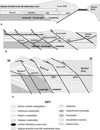
Figure 11. Schematic staged reconstruction of the Almacık complex, demonstrating how subcontinental Sakarya basal crust and mantle could have been emplaced into its present position vis-à-vis the İstanbul Zone. (a) Triassic pre-collisional configuration; formation of the Almacık complex as basement to an active continental margin on the north side of the Sakarya Zone. (b) Jurassic syn-collisional configuration, with future thrusting locations indicated; illustrating the location of thrusting at the time of collision; thick red lines indicate segments of the Almacık road section. (c) Jurassic post-collisional configuration, showing upthrust lower Sakarya crust before erosion; the Almacık complex following nappe stacking; the thick red line is the road section.
(1) Scarce inherited dates from the Almacık complex lack the Mesoproterozoic (‘Rondonian’) inheritance shown by the İstanbul Zone basement, thus indicating that these vestiges of continental crust were unrelated to the İstanbul Zone. Hence they are likely to have formed part of the leading margin of the Sakarya Continent, which occurs immediately to the south. The new isotopic data indicate unambiguously that the mafic-ultramafic rocks of the Almacık range are not of Precambrian (Yiğitbaş, Elmas & Yılmaz, Reference Yİğİtbaş, Elmas and Yılmaz1999; Yiğitbaş et al. Reference Yİğİtbaş, Kerrich, Yılmaz, Elmas and Xie2004), Palaeozoic (Abdüsselamoğlu, Reference Abdüsselamoǧlu1959; Gözübol, Reference Gözübol1980) or Late Cretaceous age (Yılmaz, Gözübol & Tüysüz, Reference Yılmaz, Gözübol, Tüysüz, Işıkara and Vogel1982, Yılmaz et al. Reference Yılmaz, Genç, Yİğİtbaş, Bozcu and Yılmaz1995; Robertson & Ustaömer, Reference Robertson and Ustaömer2004) but form part of a metamorphosed Permo-Triassic Cimmeride unit on the northern margin of the Sakarya Continent. Permian and Triassic ages record crystallization of the original rock formation in the Almacık complex and mark the initiation of subduction. Because these rocks have been considered as evidence for Upper Cretaceous ophiolites and evidence for the presence of an Intra-Pontide Ocean, their evident much older age now leaves scant support for a Mesozoic (Neotethyan) Intra-Pontide Ocean in the Western Pontides. However, during the late stages of the closure of the Palaeotethys Ocean, the presence of an ‘active continental margin’ on the Sakarya (southern) side suggests that at that time the subduction zone dipped southwards.
(2) The Triassic metamorphism pre-dated the Cretaceous closure of the northern branch of the Neotethys, and was therefore unrelated to it. It seems instead to be partly a result of deepening burial of basement to the likely former Triassic Sakarya ACM during the narrowing and closure of the Palaeotethys Ocean (Fig. 11a), with subsequent collision with the İstanbul Zone. The northward dip of the thrust planes beneath the Proterozoic basement of the İstanbul Zone hints that a change of subduction polarity may have accompanied this collision, and subsequent subduction in the area appears to have been northward.
(3) Late Middle Jurassic ages (167.1 ± 2.1 Ma U–Pb zircon, 172 ± 41 Ma Sm–Nd garnet and 163 ± 20 Ma U–Pb titanite ages) record subsequent metamorphism associated with over-thickening of crust, before its incipient break-up and initiation of extension. This is consistent with late Middle Jurassic magmatism, both S-type granites (c. 165 Ma plutonism, see Fig. 7 in Yiğitbaş, Elmas & Yılmaz, Reference Yİğİtbaş, Elmas and Yılmaz1999) and subalkaline basaltic lavas (Genç & Tüysüz, Reference Genç and Tüysüz2010). Peregrinations of the microcontinent of which the İstanbul Zone formed a part during the Palaeozoic left little mark on its ‘southern’ passive margin. Even following its accretion to Laurussia and throughout the Mesozoic, no further metamorphism occurred. This means that during the collision with the Sakarya Continent in the Triassic period it was not deeply buried, indicating that it was thrust over the Sakarya ACM.
(4) Jurassic volcanism is recorded by the presence of dominantly subalkaline basaltic lavas within the Mudurnu Formation (Genç & Tüysüz, Reference Genç and Tüysüz2010). These authors described the Mudurnu volcanics as bimodal, with a subduction signature, yet formed in an extensional setting. They could have been erupted in the Sakarya back-arc basin following the collision of the Sakarya ACM with the İstanbul Zone a short distance to the north.
(5) 139 ± 2 Ma Rb–Sr biotite ages may record cooling during extensional exhumation. Continental fluvial clastic sediments of the Bürnük Formation and shallow-marine carbonates of the İnaltı Formation (Callovian to Berriasian; Derman, Reference Derman1990) are common cover units of the İstanbul Zone and the Ballıdağ-Küre unit (Şengör & Yılmaz, Reference Şengör and Yılmaz1981; Yiğitbaş, Elmas & Yılmaz, Reference Yİğİtbaş, Elmas and Yılmaz1999), Similarly, Callovian rocks are unconformable above older units in the Sakarya Zone (e.g. Altıner et al. Reference Altıner, Koçyİğİt, Farinacci, Nicosia and Conti1991; Koçyiğit et al. Reference Koçyİğİt, Altıner, Farinacci, Nicosia and Conti1991), thus marking an important event in the history of both the İstanbul and Sakarya zones. Discussion of the significance of Middle Jurassic – Early Cretaceous units in the Western Pontides and the Sakarya Zone is therefore needed, but as they are coeval with the Rb–Sr biotite ages, they may likewise record an extensional environment.
(6) In the later stages of collision, southward-directed thrusting must have detached the basement to the leading edge of Sakarya from the downward-moving plate and thereby brought it back up to much shallower depths. Imbrication of these rocks produced the structural slices which are now an important feature of the Almacık complex, as illustrated by the schematic diagrams in Figure 11. At this time the Almacık complex may have been exhumed as a horst comprising at least four thrust slices within the collision zone, and tilted so that nappes comprising slices of the former Permo-Triassic Sakarya ACM basal continental crust and subcrustal mantle are now exposed at the surface (Fig. 11b, c).
(7) The equivalence of the Almacık complex and the Çele mafic complex remains unproven, but the lack of any Proterozoic dates obtained from the latter, despite its structural position beneath rocks of proven Proterozoic age, implies that it may prove to be an extension of the Permo-Triassic Almacık complex. Geochemical comparisons do not necessarily rule out this possibility.
(8) If the Çele and Almacık complexes are related, the contact between the İstanbul Zone and Sakarya-related rocks may dip north at a shallow angle, in a similar relationship to that of the Baltic Craton and accreted Avalonian and Variscide zones beneath Germany and Poland (e.g. Bayer et al. Reference Bayer, Scheck, Rabbel, Krawczyk, Gotze, Stiller, Beilecke, Marotta, Barrio-Alvers and Kuder1999; Grad, Guterch & Mazur, Reference Grad, Guterch, Mazur, Winchester, Pharaoh and Verniers2002). This shallow-dipping contact, the İstanbul Zone basal thrust, marking the original Rheic Suture in NW Turkey, has since been displaced by splays of the near-vertical North Anatolian Fault Zone.
(9) We suggest that what is currently interpreted as the Intra-Pontide Ocean and mapped as the Intra-Pontide Suture in NW Turkey may well be the Palaeotethys Ocean and its suture, respectively. But, if there is evidence for a Mesozoic Neotethyan branch in the region (which is not yet documented), then the suture zone, the Armutlu–Ovacık zone of Elmas & Yiğitbaş (Reference Elmas and Yİğİtbaş2001), would then provide evidence for both the Palaeotethys and Neotethys oceans, and possibly the Rheic Ocean too. The recognition of relict components of each ocean is particularly hampered by later reworking along the segments of the North Anatolian Fault Zone.
Acknowledgements
This research was funded by TÜBİTAK grant 104Y151 and partially by the Turkish Academy of Sciences to EB. Funding from TÜBİTAK for JAW to visit Turkey is gratefully acknowledged. Technical assistance in sample preparation and crushing at METU, Ankara, was greatly appreciated. Thanks are also due to David Emley, who provided expert analytical assistance at Keele, and to NERC Isotope Geosciences Laboratory (UK) staff Adrian Wood for assistance with mineral separation, and Matt Horstwood and Vanessa Pashley for assistance with LA-MC-ICP-MS set-up. Tuncay Taymaz is thanked for invaluable assistance during fieldwork, but this work would not have been undertaken without the considerable help from, and many discussions with, Erdinç Yiğitbaş, who provided an introduction to the complex geology of the area. Comments on the significance of plagiogranites by Osman Parlak are very helpful. We also thank two reviewers whose critical comments have significantly improved the text.


