1. Introduction
The South China Sea (SCS) is one of the youngest marginal ocean basins bordered by the South China Block, Indochina Block, Luzon arc and Palawan, and is an important feature for reconstructing the Cenozoic tectonic evolution of Southeast Asia (Fig. 1a) (Taylor & Hayes, Reference Taylor, Hayes and Hayes1980; Tapponnier et al. Reference Tapponnier, Lacassin, Leloup, Schärer, Zhong, Wu, Liu, Ji, Zhang and Zhong1990; Briais, Patriat & Tapponnier, Reference Briais, Patriat and Tapponnier1993; Lee & Lawver, Reference Lee and Lawver1995; Flower, Tamaki & Hoang, Reference Flower, Tamaki, Hoang, Flower, Chung, Lo and Lee1998; Zhang, Xiong & Wang, Reference Zhang, Xiong and Wang2001; Barckhausen & Roeser, Reference Barckhausen, Roeser, Clift, Kuhnt, Wang and Hayes2004; Xia et al. Reference Xia, Cui, Zhang, Liu, Wang and Yan2005; Barckhausen et al. Reference Barckhausen, Engels, Franke, Ladage and Pubellier2014; Li et al. Reference Li, Xu, Lin, Sun, Zhu, Yao, Zhao, Liu, Kulhanek, Wang, Song, Zhao, Qiu, Guan, Zhou, Williams, Bao, Briais, Brown, Chen, Clift, Colwell, Dadd, Ding, Almeida, Huang, Hyun, Jiang, Koppers, Li, Liu, Liu, Nagai, Peleo-Alampay, Su, Tejada, Trinh, Yeh, Zhang, Zhang and Zhang2014). The spreading of the South China Sea began from early Oligocene time and continued until early–middle Miocene time (~32 to ~15.5 Ma), according to magnetic anomaly mapping (anomalies 11 to 5d, Taylor & Hayes, Reference Taylor, Hayes and Hayes1980, Reference Taylor, Hayes and Hayes1983; revised to anomalies 11 to 5c, Briais, Patriat & Tapponnier, Reference Briais, Patriat and Tapponnier1993). Although the final spreading time of the South China Sea is considered to range between 10 Ma and 15 Ma according to seismic stratigraphic data of several sub-basins (Franke et al. Reference Franke, Savva, Pubellier, Steuer, Mouly, Auxietre, Meresse and Charmot-Rooke2014), Arfai et al. (Reference Arfai, Franke, Gaedicke, Lutz, Schnabel, Ladage, Berglar, Aurelio, Montano and Pellejera2011) indicated that the onset of the subduction of the South China Sea oceanic plate under the Manila Trench in the east marked the cessation of sea-floor spreading. Coincident 15 Ma geological features such as the commencement of the volcanic belt along western Luzon (Pubellier et al. Reference Pubellier, Garcia, Loevenbruck and Chorowicz2000), and the beginning of the Palawan/Mindoro–Central Philippines collision (Yumul et al. Reference Yumul, Dimalanta, Tamayo and Maury2003) are seen as supporting evidence for the age determination for the cessation of South China Sea sea-floor spreading, and is further implied as the timing for subduction of the oldest crust. However, there is no evidence that sea-floor spreading did not continue after the initial onset of subduction as a considerable portion of the inferred oceanic crust was subducted.

Figure 1. (a) Map of the South China Sea, Southeast Asia and (b) the location of the ETO. Simplified geological map of the Coastal Range region of Taiwan (revised from Liou, Reference Liou1979).
Accessible remnants of the South China Sea are preserved within the Lichi mélange of the Coastal Range in eastern Taiwan. These oceanic rocks consist of fragments of fossiliferous sea-floor sediments, pillow basalt, glassy basalt, gabbro, basaltic dykes, plagiogranite and serpentinized peridotite, and are known as the East Taiwan Ophiolite (ETO) (Liou et al. Reference Liou, Lan, Suppe and Ernst1977; Jahn, Reference Jahn1986; Chung & Sun, Reference Chung and Sun1992). The nature and tectonic setting of the ETO is a topic that is still under debate (Suppe, Liou & Ernst, Reference Suppe, Liou and Ernst1981; Jahn, Reference Jahn1986; Chung & Sun, Reference Chung and Sun1992; W. Y. Shao, unpub. Ph.D. thesis, National Taiwan Univ., 2015). Based on the stratigraphy of the Lichi Formation, Suppe, Liou & Ernst (Reference Suppe, Liou and Ernst1981) suggested that the ETO is a submarine scree deposit consisting of angular mafic and ultramafic plutonic blocks that formed at a ‘leaky’ transform fault offset. Jahn (Reference Jahn1986), however, interpreted the ETO as a spreading ridge from an open ocean or marginal basin based upon the geochemical and isotopic data of the glassy basalts, gabbros and plagiogranites, whereas Chung & Sun (Reference Chung and Sun1992) proposed the ETO formed in a slow-spreading ridge environment.
The bulk-rock geochemistry and mineral geochemistry of oceanic peridotites can be used to distinguish between different tectonic settings (Dick & Bullen, Reference Dick and Bullen1984; Bonatti & Michael, Reference Bonatti and Michael1989; Arai, Reference Arai1992, Reference Arai1994; Kamenetsky, Crawford & Meffre, Reference Kamenetsky, Crawford and Meffre2001; Hebert et al. Reference Hebert, Hout, Wang, Liu, Dilek and Robinson2003). Some major and trace elements such as Mg, Cr and Al, which are relatively immobile during serpentinization, can retain their original concentration and thus help to identify the possible tectonic setting. New spinel mineral chemistry, whole-rock major and trace elemental data and Sr–Nd isotopes of the serpentinized peridotites and an in situ zircon U–Pb date of a hornblende gabbro are presented in order to constrain the tectonic setting and age of the ETO within the context of the regional tectonic development of the South China Sea.
2. Geological and tectonic background
Taiwan is situated at the junction between the Ryukyu arc and the Luzon arc and is an amalgamation of accretionary wedge rocks, island arc rocks and older continental and oceanic lithosphere (Chai, Reference Chai1972; Bowin et al. Reference Bowin, Lu, Lee and Schouten1978; Suppe, Reference Suppe1984; Tsai, Reference Tsai1986; Kao, Shen & Ma, Reference Kao, Shen and Ma1998). Westward subduction of the Pacific plate beneath the Eurasian plate during Mesozoic time (~150 Ma) created the Zhejiang–Fujian magmatic arc and proto-Taiwan. As subduction slowed during early Cenozoic time, the slab began to roll back eastwardly until the palaeo-Pacific plate eventually stopped subducting. The changing nature of convergence between the palaeo-Pacific plate and Eurasia allowed sediments to accumulate in a fore-arc basin setting as the Philippine Sea plate rotated clockwise in a northwestward direction (Lee & Lawver, Reference Lee and Lawver1995). During middle to late Miocene time (~15-12 Ma), the Luzon arc migrated towards the Eurasian continental shelf along a left-lateral transform fault compensating the northward subduction of the northern Philippine Sea plate under the Ryukyu arc (Teng, Reference Teng1990; Huang, Yuan & Tsao, Reference Huang, Yuan and Tsao2006). The obduction between the Luzon arc and Eurasian continental shelf uplifted the accretionary wedge as the proto-Central Mountain Range of Taiwan during mid to late Pliocene time (Teng, Reference Teng1990; Huang, Yuan & Tsao, Reference Huang, Yuan and Tsao2006). By late Pliocene time, the northern Luzon arc obliquely collided into Eurasia and reached its current position off the east coast of Taiwan. The volcanic rocks of the Luzon arc accreted to the uplifted Pliocene–Pleistocene passive margin sediments of Eurasia and became the Coastal Range, whereas the uplifted sedimentary rocks developed into the Central Range. Concurrent with the Luzon–Eurasia collision, NE Taiwan transformed from compression to extension as the Philippine Sea plate continue to subduct under the Ryukyu arc, which induced back-arc extension and the opening of the Okinawa Trough (Teng, Reference Teng1990, Reference Teng2007; Kao, Shen & Ma, Reference Kao, Shen and Ma1998) and the Yilan basin by the collapsing of the Yilan terrane (Suppe, Reference Suppe1984; Lee & Wang, Reference Lee and Wang1987; Teng, Reference Teng1990, Reference Teng1996, Reference Teng2007).
The ~140 km long Coastal Range of eastern Taiwan is one of the five main mountain ranges of the island and stretches from the Hualien River in the north to Beinan Mountain in the south (Fig. 1b). The Coastal Range is separated into a slightly higher but no longer uplifting northern portion (Chen, Huang & Liu, Reference Chen, Huang and Liu1991) and a lower but still uplifting southern portion with abundant river terraces cut by the Siouguluan River. The Longitudinal Valley situated between the Central Range and Coastal Range marks the boundary between Eurasia and the Philippine Sea plate. The Central Range is underlain by deformed rocks of the Eurasian continental margin while the Coastal Range is underlain by island arc volcanic rocks from the Luzon arc (Pagé & Suppe, Reference Pagé and Suppe1981).
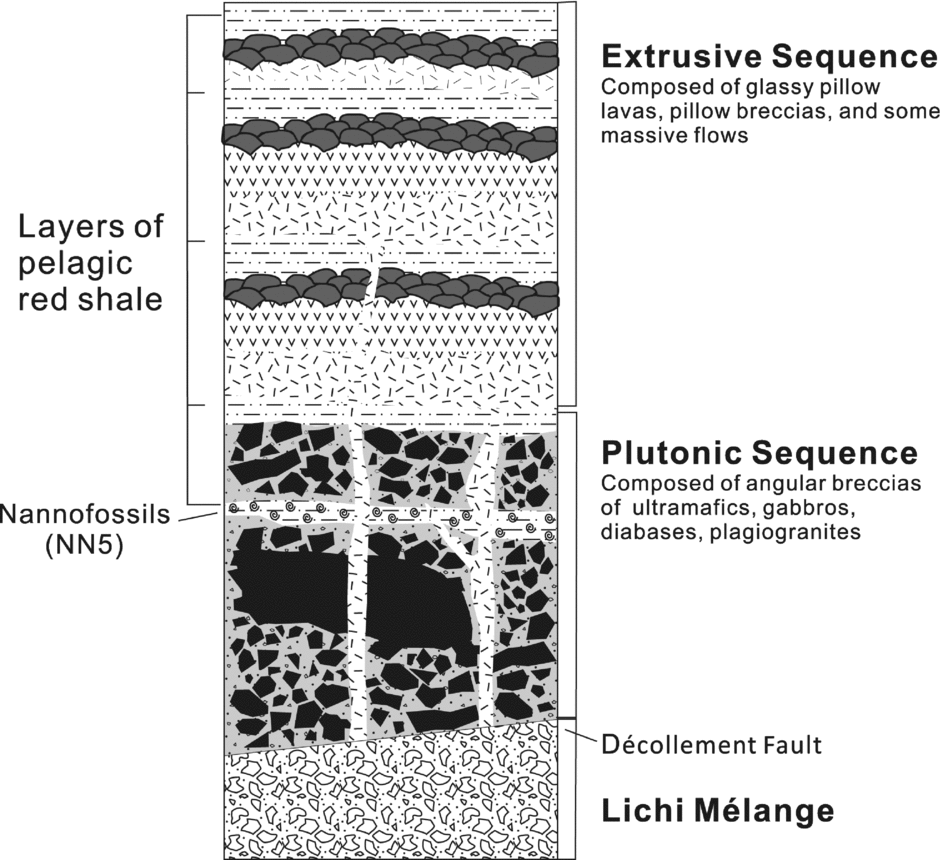
The ETO is sporadically exposed along the southeastern part of the Coastal Range and is considered to be a remnant of the South China Sea (Liou et al. Reference Liou, Lan, Suppe and Ernst1977; Suppe & Liou, Reference Suppe and Liou1979; Liou, Reference Liou1979; Suppe, Liou & Ernst, Reference Suppe, Liou and Ernst1981; Jahn, Reference Jahn1986; Chung & Sun, Reference Chung and Sun1992). Liou et al. (Reference Liou, Lan, Suppe and Ernst1977) provided a detailed geological and geochemical investigation that interpreted the ETO as an ocean ridge. The interpretation by Liou et al. (Reference Liou, Lan, Suppe and Ernst1977) has since been modified and constrained into the current synthesis as shown in Figure 2 (Suppe, Liou & Ernst, Reference Suppe, Liou and Ernst1981; Jahn, Reference Jahn1986; Chung & Sun, Reference Chung and Sun1992). For this study, samples were collected at Dianguang, Guanshan Township, along the Chiawu creek that exposes the largest contiguous outcrop of the ETO. Rocks were collected along a 1.6 km traverse from midstream to the headwater. The serpentinized peridotites were collected near the headwater of the creek whereas the gabbro was collected closer to the start of the traverse.

Figure 2. Idealized stratigraphy of the ETO (revised from Liou et al. Reference Liou, Lan, Suppe and Ernst1977).
3. Petrography
The peridotites mostly (≥ 90 vol.%) comprise serpentine with minor amounts of orthopyroxene pseudomorphs (≥ 5 vol.%) and spinel (≥ 1 vol.%). The original texture of the rock has been replaced but the serpentine suggests the rock was poikilitic. Small iron-oxide minerals form anastomosing bands which give the appearance of former grain boundaries. The oxide minerals are likely the result of olivine serpentinization. There are rare occurrences of partly altered (i.e. pseudomorphic?) olivine which range in size from 0.5 mm to ~1 mm and still have discernable hexagonal to rounded shapes. Orthopyroxene pseudomorphs range in size from 0.5 mm to 3.5 mm and represent ~5% of the rock mode. The orthopyroxene pseudomorphs are commonly round and larger than the pseudomorphic olivine, have a distinct relief from the serpentine and still have visible cleavage that makes them relatively easy to identify. Subhedral to anhedral spinel is commonly observed and is between 0.5 and 2 mm in length and dark red in plain-polarized light (Fig. 3). Magnetite- and calcite-rich veins are common and are likely due to the hydrothermal alteration of the original silicate minerals.
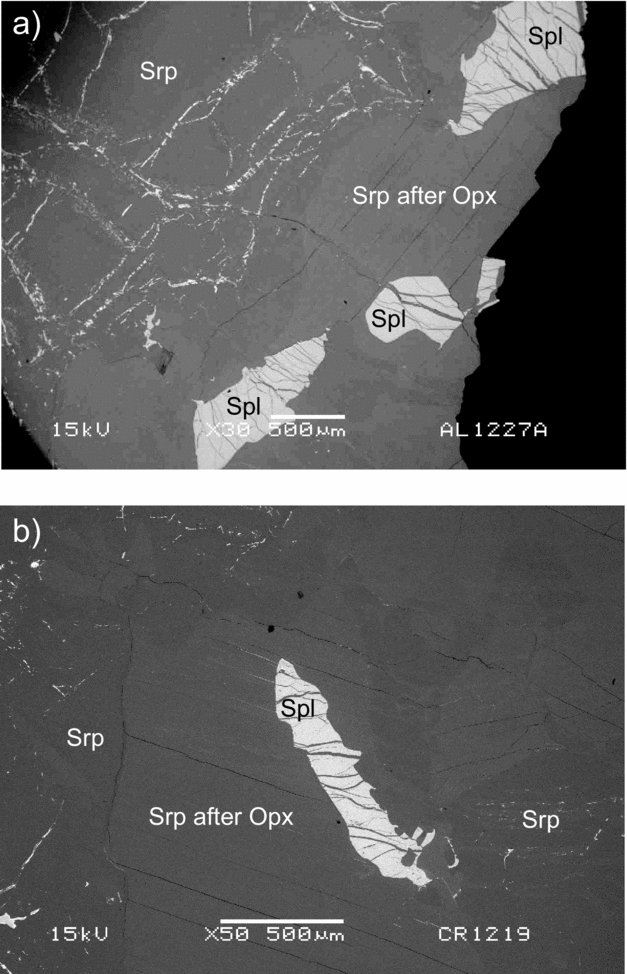
Figure 3. Back-scattered electron images of typical ETO Cr-spinel from (a) sample TD01003 and (b) TD01007. Spl – Cr-spinel; Srp – serpentine; Opx – orthopyroxene.
The gabbro is coarse grained and granular and consists of ~55% hornblende and ~45% plagioclase with accessory quantities (i.e. < 1 vol.%) of ilmenite and/or magnetite. The hornblende is light green under plain-polarized light with second-order interference colours under crossed polars. The hornblende crystals are euhedral to subhedral and tend to be smaller (i.e. 0.1 mm) than the subhedral to anhedral plagioclase crystals (i.e. > 0.5 mm). The oxide minerals are small (i.e. < 0.05 mm), sub- to anhedral and commonly bordering plagioclase rather than hornblende.
4. Methods
4.a. Electron probe micro-analyser (EPMA)
An electron probe micro-analyser (EPMA) was used to determine the major element composition of the Cr-spinel. For the analyses, the sample mounts were coated with carbon using a Quorum Technology Q150TE high vacuum carbon coater and loaded into the EPMA. For this study, a JEOL W-EPMA model JXA-8900-R with four wavelength dispersive spectrometers (WDS) at the Laboratory of Electron Probe Micro-Analyses, Institute of Earth Science, Academia Sinica was used. The electron beam was defocused at an interval of approximately 10 mm on an area of about 5 µm diameter with beam conditions of 15 kV and 12 nA. Back-scattered electron images were used to guide the analysis on target positions of minerals. The measurements were corrected by using standard minerals as follows: wollastonite for Si and Ca, rutile for Ti, corundum for Al, chrome oxide for Cr, haematite for Fe, tephroite for Mn, pyrope for Mg, nickel olivine for Ni, albite for Na, and adularia for K. Peak counting for each element and both upper and lower baselines were counted for 10 s and 5 s, respectively. Relative standard deviations (RSD) for all elements were less than 1%.
4.b. Zircon U–Pb geochronology
Zircons were mechanically separated at the Yu-Neng Rock and Mineral Separation Co., Lanfang, Hubei province, China, using conventional heavy-liquid and magnetic separation techniques. Zircons were linearly mounted and polished to approximately half the mean grain thickness. A panchromatic cathodoluminescence (CL) imaging system (Gatan Mini-CL) attached to a scanning electron microscope (JOEL JSM-6360LV) was used to capture CL images of individual zircons to examine their internal structure. Laser ablation inductively coupled plasma mass spectrometer (LA-ICP-MS) U–Pb dating was carried out using an Agilent 7500cx quadrupole ICP-MS with a New Wave UP-213 laser ablation system at the Tectonics and Low-Temperature Heat Dating Laboratory, Department of Earth and Environmental Sciences, National Chung-Cheng University, Taiwan. The GJ-1 zircon was used as a standard for instrumental drift correction, which yielded an average 207Pb–206Pb age of 600±5 Ma during experiments. The measured results of the zircon standard are within error of the reported age provided by thermal ionization mass spectrometry (TIMS) analyses by Jackson et al. (Reference Jackson, Pearson, Griffin and Belousova2004). The Plešovice zircon standard (337±10 Ma) was used as a secondary standard for measurement quality control. Operating conditions and analytical procedures were the same as those reported by Chiu et al. (Reference Chiu, Chung, Wu, Liu, Liang, Lin, Iizuka, Xie, Wang and Chu2009). Individual zircons were ablated using a beam diameter of 40 μm and frequency of 10 Hz.
4.c. X-ray fluorescence spectrometry (XRF)
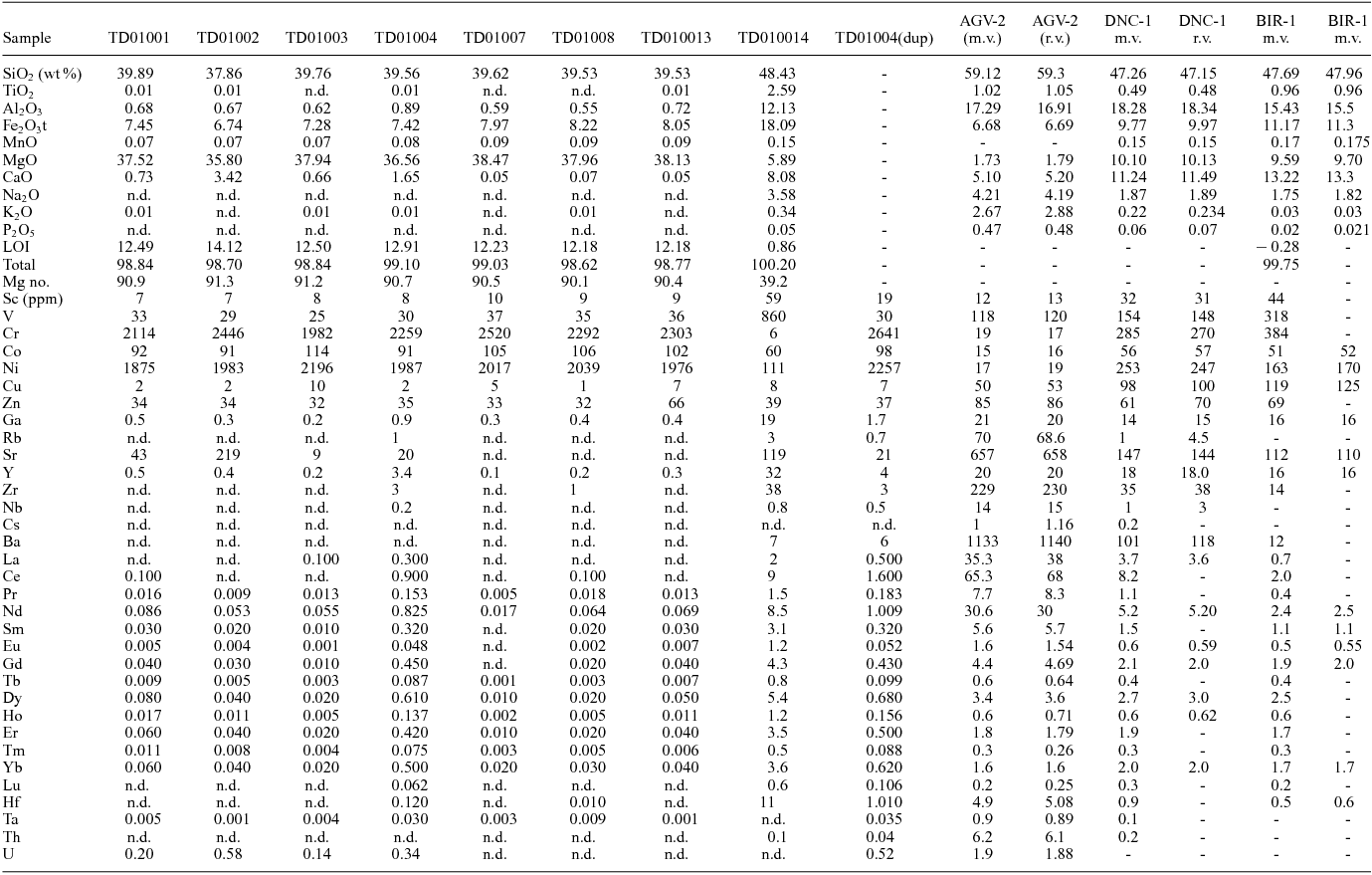
Approximately 3 g of rock powder from each sample was heated to 100°C for 3 hours to release ambient water from the sample and then heated to 900°C for 6 hours to oxidize and release molecular water. The net weight change was recorded at each step and used to calculate the loss on ignition (LOI). A sample of 0.6 g of rock powder was thoroughly mixed with 6 g of Claisse® lithium borate with lithium bromide flux (49.75% Li2B4O7, 49.75% LiBO2 with 0.5% LiBr). The mixed powder and flux was added to platinum (95%) and gold (5%) crucibles and fused at ~1200°C to make a glass bead using a Claisse® M4 Fluxer. The analysis was conducted by a Panalytical AxiosmAX XRF spectrometer at the Department of Earth Sciences, National Taiwan Normal University. Standard reference materials analysed concurrent with the samples included AGV-2 (andesite), BIR-1a (Icelandic basalt) and DNC-1a (dolerite).
4.d. Inductively coupled plasma mass spectrometry (ICP-MS)
The bulk-rock trace element analyses were determined using a quadrupole inductively coupled plasma mass spectrometer (Q-ICP-MS, model Agilent 7500s) at the Geochemistry and Petrogenesis Lab, Department of Geosciences, National Taiwan University. The dissolved sample liquids used for ICP-MS were extracted using the same procedure as the Sr and Nd isotopes. The standard reference materials measured for the trace elements were AGV-2, BIR-1 and DNC-1 with a precision better than 5% (2σ) for most trace elements.
4.e. Thermal ionization mass spectrometry (TIMS)
The samples were dissolved using hydrofluoric acid (HF), nitric acid (HNO3) and hydrochloric acid (HCl). The concentrates were loaded on a double rhenium filament. In this research, a Thermo Finnigan™ Mat GmbH MAT262Q thermal ionization mass spectrometer was used for Sr isotope analysis and a Thermo Scientific™ Triton Plus multicollector thermal ionization mass spectrometer was used for Nd isotope analysis, both at the Mass Spectrometer Lab, Institute of Earth Science, Academia Sinica.
5. Results
5.a. Spinel chemistry
The averaged Cr-spinel compositions are shown in Table 1 and the full results are listed in the online Supplementary Material Table S1 available at http://journals.cambridge.org/geo. The Cr2O3 content ranges from ~35 wt% for TD01001, to an intermediate range between 38 and 41 wt% for TD01002, TD01003 and TD01004 and a slightly higher concentration of 41 to 46 wt% for samples TD01007, TD01008 and TD01013. The mean aluminium content of all samples is ~26.5 wt%, while samples TD01001 and TD01003 have higher concentrations (32 and 29 wt%) and TD01008 and TD01013 have lower concentrations (25 wt%). The Cr3+ and Alvi cations are used to calculate the Cr no. ((Cr3+/(Cr3++Alvi))*100). The mean Cr no. of all samples is ~51.2. Sample TD01001 has the lowest average Cr no. of 43, whereas all other samples have values > 47. The highest average Cr no. is 54.2 from TD01008. The MgO content of the spinel is relatively constant at ~15 wt% but their overall range is from 12 wt% to 17 wt%. Total iron content for all samples is between 13 wt% and 17 wt%. The Mg no. (i.e. Mg no. (((Mg2+/(Mg2++Fe2+))*100)) values are between 58 and 74. The concentrations of the remaining oxides (SiO2, TiO2, MnO, NiO, CaO, Na2O and K2O) are lower than 0.5 wt%.
Table 1. Average spinel compositions from the ETO peridotites
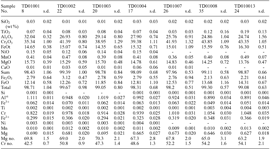
No. – number of averaged analyses; s.d. – standard deviation; Mg no. = (Mg/Mg+Fe2+))*100; Cr no. = (Cr/(Cr+Al))*100.
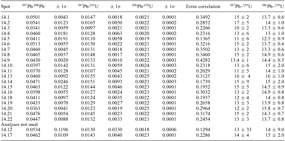
5.b. Zircon U–Pb geochronology
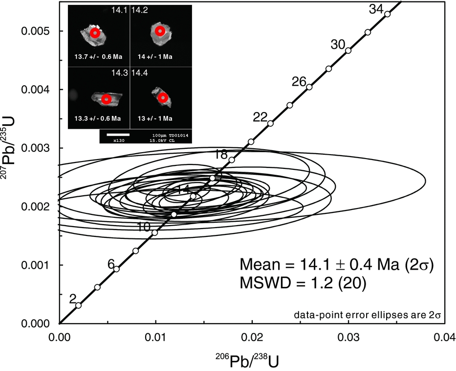
The analysed zircons are ~100 to ~250 μm in diameter and have anhedral fragmented shapes. Some of the zircons have oscillatory zoning whereas others have complicated internal structures. Common lead was corrected using the common lead correction function of Andersen (Reference Andersen2002, Reference Andersen and Sylvester2008). The U–Pb results are shown in Table 2. The Concordia diagram, constructed using Isoplot 3.0 (Ludwig, Reference Ludwig2003), is shown in Figure 4 with 2σ error ellipses of the individual spot analyses. The weighted mean 206Pb–238U age is 14.1±0.4 Ma on 20 individual zircon crystals and the MSWD (mean square weighted deviation) is 1.2 (Fig. 4). Owing to the young age of the zircons, the 207Pb–235U age has a larger uncertainty and thus has less significance.
Table 2. Zircon LA-ICP-MS geochronology results from the hornblende gabbro


Figure 4. 207Pb–235U v. 206Pb–238U Concordia plot of the zircons from the ETO hornblende gabbro with cathodoluminescence images of typical zircons.
5.c. Major and trace elemental chemistry
The serpentinized peridotites have 37.9 to 39.9 wt% SiO2, 35.8 to 38.5 wt% MgO, 6.7 to 8.2 wt% Fe2O3 and < 1.0 wt% Al2O. TiO2, MnO, Na2O, K2O and P2O5 contents are close to the detection limit and/or not detected (Table 3). CaO content is more variable and is likely owing to the presence of secondary calcite veins in the rock. The Mg nos (((Mg2+/(Mg2++Fe2+))*100)) of the serpentinized peridotite samples are between 90 and 92.
Table 3. Major and trace elemental data of the spinel peridotite and gabbro
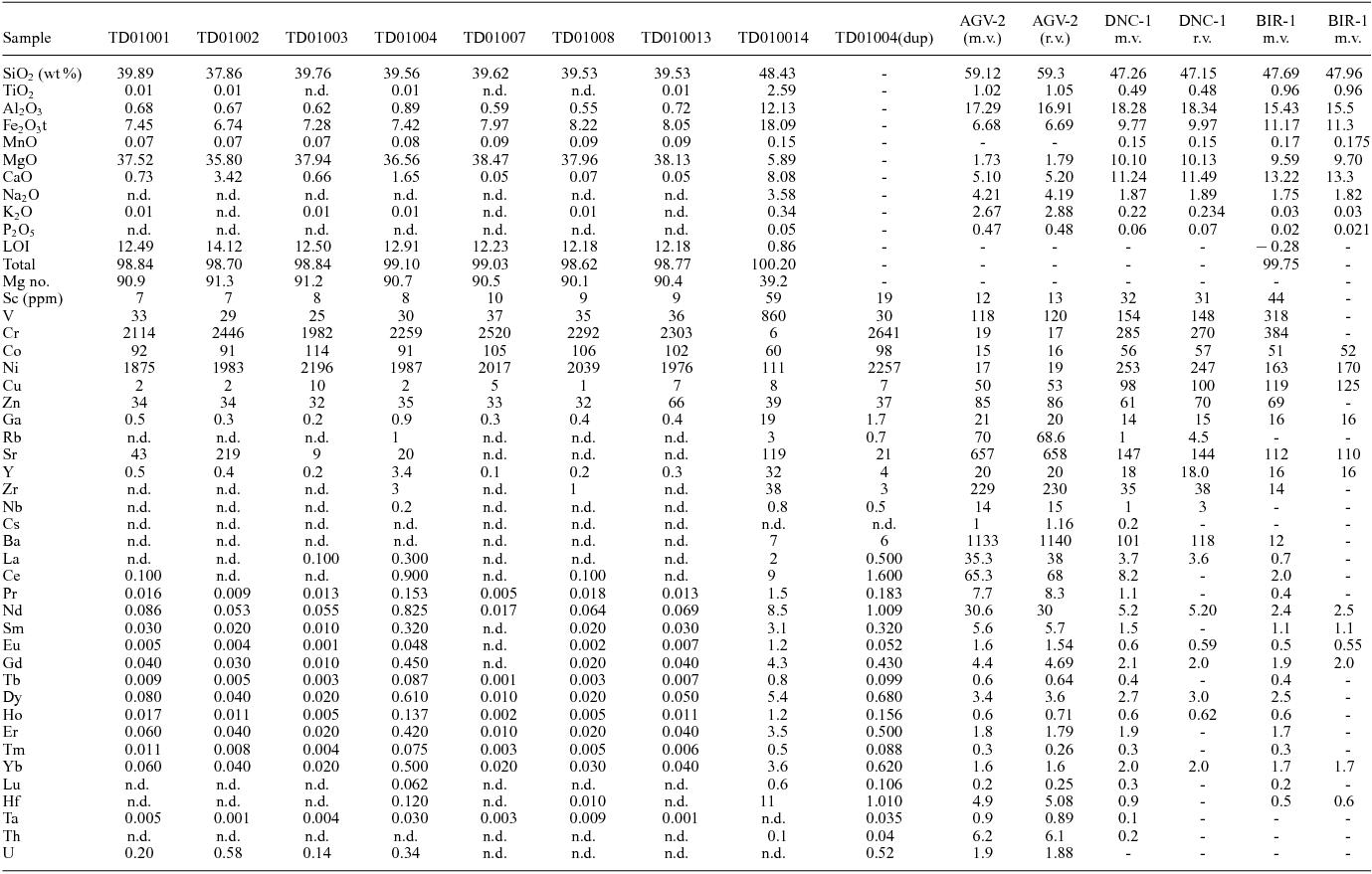
LOI – loss on ignition; Mg no. = (Mg2+/(Mg2++Fe2+))*100; FeO – 0.8998*Fe2O3t; dup – duplicate; m.v. – measured value; r.v. – recommended value; n.d. – not detected.
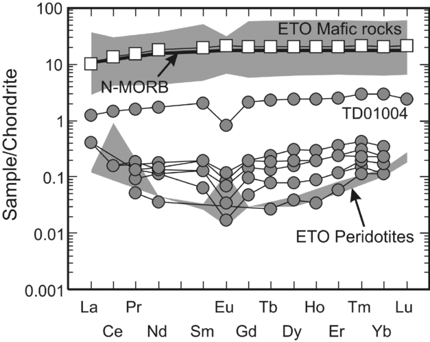
The trace element concentrations of the serpentinized peridotites are quite low except for the transition metals (i.e. Sc, Ti, V, Cr, Mn, Co, Ni, Cu, Zn). Sr concentration in TD01002 (~219 ppm) is several times higher than in other samples (< 43ppm). Sample TD01004 has a greater abundance of the high-field-strength and large-ion-lithophile elements (i.e. Ga, Rb, Y, Zr, Nb, Cs, Ba, Hf, Ta, Th) than the other samples. The rare earth element (REE) concentrations of all the serpentinized peridotites except TD01004 are low (< 0.1ppm). TD01004 has much higher concentrations of REEs (~10 times) with an ‘N-MORB-shaped’ pattern whereas the other samples have a U-shaped pattern and negative Eu anomaly (Fig. 5). The REE concentrations are about 0.1 times C1 chondrite concentration, except TD01004, which has one to two times chondrite concentration.

Figure 5. Chondrite-normalized REE plots of the spinel peridotites and hornblende gabbro. Normalized values are from Sun & McDonough (Reference Sun, McDonough, Saunders and Norry1989) and the range of ETO basalts and peridotites from Jahn (Reference Jahn1986).
The gabbro has 48.4 wt% SiO2, 2.6 wt% TiO2 and a Mg no. of 39 and classifies as normal mid-ocean ridge basalt (N-MORB) (Mullen, Reference Mullen1983). The transition metals are quite variable as V (~860ppm), Ni (111ppm) and Co (60ppm) are relatively high whereas Cr (~6ppm) and Cu (~8ppm) are low. The chondrite-normalized REE pattern is light rare earth element (LREE) depleted (i.e. La/YbN = 0.4) and similar to N-MORB and other mafic rocks of the ETO (Fig. 5).
5.d. Sr–Nd isotope geochemistry
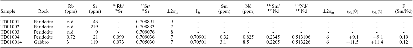
The 87Sr/86Sr isotope ratio of four samples (i.e. TD01001, TD01002, TD01003 and TD01004) ranges between 0.70883 and 0.70908 (Table 4). The initial 87Sr/86Sr values cannot be calculated (i.e. TD01001, TD01004, TD01003) owing to the extremely low Rb content (i.e. below detection limit) but given their likely age (i.e. ~14 Ma) the measured value will not be significantly different from the initial values (i.e. ± 0.00001). Sample TD01004 was the only one that had detectable quantities of Sm and Nd and produced a measured 143Nd/144Nd ratio of 0.513106. The initial ratio based on the age of the gabbro is 0.513083 and corresponds to an εNd(t) value of +9.1 using a CHURtoday value of 0.512638 (Fig. 6). The gabbro has a measured 87Sr/86Sr isotope ratio of 0.70503 and corresponds to a 87Sr/86Sri value of 0.70501. The measured 143Nd/144Nd isotope ratio is 0.513226 with an εNd(t) value of +11.4 (Fig. 6).
Table 4. Sr–Nd isotopes of the peridotite and gabbro from the ETO

Rb, Sr, Sm and Nd concentrations were obtained by ICP-MS and the precisions are better than ±2%. The results of isotopic measurements for Sr and Nd reference materials are NBS-987 (Sr) = 0.710248±3 (2σm); JMC (Nd) = 0.511813±10 (2σm). f(Sm/Nd) is defined as ((147Sm/144Nd)/0.1967−1). εNd(t) is calculated using an approximate equation of εNd(t) = εNd(0)−Q*f*T, in which Q = 25.1 Ga−1; f = f(Sm/Nd); T age = 0.015 Ga; TDM−1 = (1/λ)*ln(1+((143Nd/144Nd)m−0.51315)/((147Sm/144Nd)m−0.2137)); λ = 0.00654 Ga−1.

Figure 6. Initial Sr and Nd isotopes of the ETO rocks including the peridotite and gabbro from this study. Previously reported data from Jahn (Reference Jahn1986) and Chung et al. (Reference Chung, Cheng, Jahn, O'Reilly and Zhu1997). The Sr isotopes were likely affected by seawater alteration.
6. Discussion
6.a. Age of the East Taiwan Ophiolite
Huang, Chen & Chi (Reference Huang, Chen and Chi1979) first attempted to determine the age of the ETO by identifying foraminifera species Sphenolithus heteromorphus and Calcidiscus macintyrei within red shales from nanofossil zone NN5, which constrains the deposition age to lower and middle Miocene. Jahn (Reference Jahn1986) reported the first radioisotopic ages for two types of basaltic rock (i.e. glass and crystalline), plagiogranite and gabbro using the K–Ar method. The results produced four different ages: 33±5 Ma (plagiogranite), 14.6±0.4 Ma (basaltic glass), 11±4 Ma (gabbro) and 8.1±0.9 Ma (crystalline basalt). Consequently, Jahn (Reference Jahn1986) interpreted the likely age of the ETO to be 14.6±0.4 Ma based on mutual consistency with the palaeontological interpretations of Huang, Chen & Chi (Reference Huang, Chen and Chi1979). Recently, U–Pb age dates were reported by W. Y. Shao (unpub. Ph.D. thesis, National Taiwan Univ., 2015) on gabbro and diorite from the north branch of the Chiawu creek. The concordant ages of the gabbros are ~17.5 Ma (i.e. 17.5±0.2 Ma and 17.4±0.2 Ma) whereas the diorites are 14.3±0.5 Ma and plagiogranites are 14.1±0.2 Ma.
The mean zircon U–Pb date from the hornblende gabbro (i.e. 14.1±0.4 Ma) in this study is in agreement with the previous suggested age range: the K–Ar age of the basaltic glass (Jahn, Reference Jahn1986), the U–Pb zircon age of the diorite group (W. Y. Shao, unpub. Ph.D. thesis, National Taiwan Univ., 2015) and the interpreted age of the syn-ETO magmatism red shale layers (Huang, Chen & Chi, Reference Huang, Chen and Chi1979). Therefore, in light of our new radioisotopic ages, the ETO is probably no older than middle Miocene. This implies that the magmatism and sea-floor spreading within the South China Sea was still active for at least ~1.5 million years after the inferred terminal age (i.e. ~15.5 Ma).
6.b. Tectonic setting of the East Taiwan Ophiolite
The rock sequence of the ETO is described in previous studies but all units that are common to the idealized stratigraphy of an ophiolite are present (Fig. 2) (Anonymous, 1972; Liou et al. Reference Liou, Lan, Suppe and Ernst1977; Liou & Ernst, Reference Liou and Ernst1979; Suppe, Liou & Ernst, Reference Suppe, Liou and Ernst1981; Chung & Sun, Reference Chung and Sun1992; Dilek, Reference Dilek, Dilek and Newcomb2003). The red shale layers between the intrusive rocks and the extrusive rocks indicate that they were exposed under the carbonate compensation depth (CCD) for a period of time, perhaps a deep-ocean setting at great distance from land (Chung & Sun, Reference Chung and Sun1992).
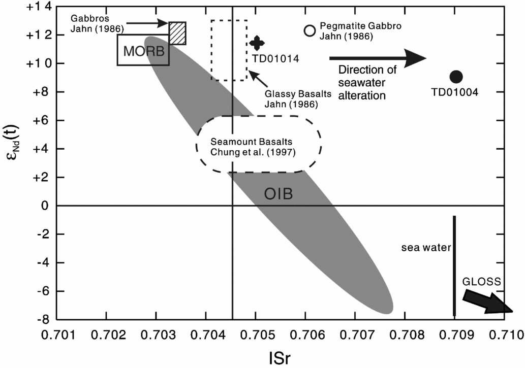
Bonatti & Michael (Reference Bonatti and Michael1989) demonstrated that whole-rock Mg no. and Al content can be effective in distinguishing peridotites derived at ridge settings, passive margin settings, pre-oceanic rift and oceanic trench settings because they are relatively immobile during serpentinization. Moreover the Cr no. and Mg no. of spinel from mantle peridotite are useful for interpreting the tectonic setting because they are indicators of the degree of depletion within the mantle source and also they are relatively unaffected by hydrothermal conditions commonly experienced by oceanic peridotites (Dick & Bullen, Reference Dick and Bullen1984; Bonatti & Michael, Reference Bonatti and Michael1989; Arai, Reference Arai1994). Figures 7 and 8 show that all serpentinized peridotites from the ETO have Mg nos (i.e. 90 to 93), bulk-rock aluminium content and spinel compositions consistent with peridotites from an ocean ridge setting.
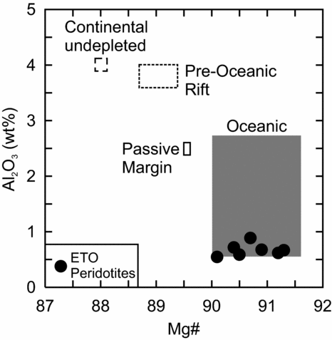
Figure 7. Range of whole-rock Mg nos and Al2O3 (wt%) of peridotites from different tectonic settings (based on Bonatti & Michael, Reference Bonatti and Michael1989).

Figure 8. Tectonic discrimination diagrams of Dick & Bullen (Reference Dick and Bullen1984) for Cr-spinel from peridotites using the (a) Cr no. and Mg no. and (b) Al2O3 and TiO2 (wt%) from the ETO.
The REE patterns of the ETO serpentinized peridotites suggest there are at least two different rock types: (1) the U-shaped patterned rocks and (2) the ‘N-MORB’-shaped patterned rock (Fig. 5). The relatively enriched ‘N-MORB’-shaped pattern for sample TD01004 is similar to spinel lherzolites from the Pyrenees whereas the flat and U-shaped patterns resemble harzburgites from the Pyrenees, but the range of compositions are typical of orogenic peridotite massifs and ophiolites in general (Prinzhofer & Allegre, Reference Prinzhofer and Allegre1985; McDonough & Frey, Reference McDonough, Frey, Lipin and McKay1989; Bodinier & Godard, Reference Bodinier, Godard, Holland and Turekian2003). The U-shaped patterns are probably not related to metasomatism by continental derived fluids (c.f. Gruau et al. Reference Gruau, Bernard-Griffiths and Lecuyer1998) because: (1) continental crust was not located near the easternmost South China Sea ridge and (2) the ETO basaltic rocks show evidence of seawater alteration rather than meteoric water (Liou & Ernst, Reference Liou and Ernst1979; Liou, Reference Liou1979; Jahn, Reference Jahn1986). Element mobility is unlikely to be the reason why there are two types of serpentinized peridotites because REEs tend to be immobile but also the patterns would be expected to be random or at least unique to the ETO rather than appearing similar to peridotites from other ophiolites or orogenic massifs (c.f. Greenough, Fryer & Robinson, Reference Greenough, Fryer, Robinson, Duncan, Backman, Peterson, Baker, Baxter, Boersma, Cullen, Droxler, Fisk, Greenough, Hargraves, Hempel, Hobart, Hurley, Johnson, Macdonald, Mikkelsen, Okada, Rio, Robinson, Schneider, Swart, Tatsumi, Vandamme, Vilks and Vincent1990; Bodinier & Godard, Reference Bodinier, Godard, Holland and Turekian2003; Pearce, Reference Pearce2014). The depletion of Eu in TD01004 could be due to seawater alteration as Eu2+ can substitute for Ca2+ in silicate mineral systems but the remaining elements do not show anomalous patterns.
The depleted εNd(t) values of the serpentinized peridotite and basaltic rocks (i.e. +9 to +11), the depleted LREE pattern (i.e. La/YbN = 0.4) and N-MORB composition of the mafic rocks, and the spinel compositions of the serpentinized peridotites are consistent with a depleted mantle source and rocks found at a sea-floor ridge setting. Therefore, the initial interpretations of Liou et al. (Reference Liou, Lan, Suppe and Ernst1977) and Jahn (Reference Jahn1986) are likely correct and that the ETO was a mid-ocean ridge setting, but it is still uncertain if it was a slow-spreading ridge as proposed by Chung & Sun (Reference Chung and Sun1992).
6.c. Preservation of the ETO
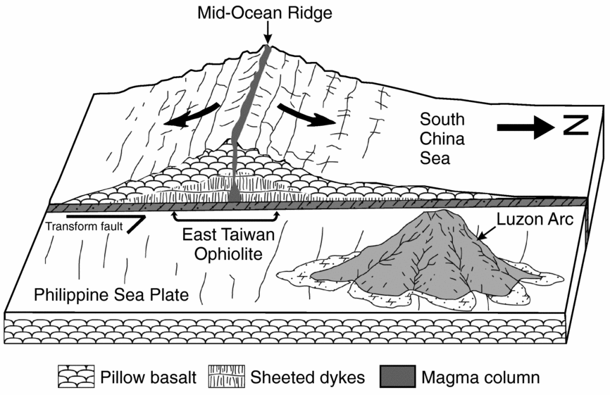
There are a number of mid-ocean ridge type ophiolites in the geological record (i.e. Macquarie Island and Masirah), but the majority of ophiolites appear to be subduction-related, probably owing to their greater likelihood of preservation (Pearce, Lippard & Roberts, Reference Pearce, Lippard, Roberts, Kokelaar and Howells1984; Stern & Bloomer, Reference Stern and Bloomer1992; Peters & Mercolli, Reference Peters and Mercolli1998; Kamenetsky et al. Reference Kamenetsky, Everard, Crawford, Varne, Eggins and Lanyon2000; Milsom, Reference Milsom, Dilek and Robinson2003; Pearce, Reference Pearce, Dilek Y and Newcomb2003; Whattam & Stern, Reference Whattam and Stern2011; Dilek & Furnes, Reference Dilek and Furnes2011, Reference Dilek and Furnes2014). Nearly all of the Western Pacific and Cordilleran belt group of ophiolites are interpreted as subduction-related (i.e. suprasubduction zone or volcanic-arc); thus, the ETO may be a unique example of a subduction-unrelated ophiolite. In some cases arc rocks are not immediately discovered within specific ophiolite complexes such as the Semail ophiolite (Whattam & Stern, Reference Whattam and Stern2011; Dilek & Furnes, Reference Dilek and Furnes2011, Reference Dilek and Furnes2014). Consequently the ETO could represent a suprasubduction zone ophiolite in which the ‘arc-like’ rocks (e.g. calc-alkaline affinity or boninite) have yet to be discovered, but that seems unlikely considering the current state of knowledge on the basaltic rocks and the results presented in this study (Jahn, Reference Jahn1986; Chung & Sun, Reference Chung and Sun1992). Therefore, the main issue regarding the ETO is the mechanism of preservation. In other words, how was the ridge of the South China Sea accreted to the margin of Eurasia?
The ETO is highly dismembered and within a sedimentary mélange that formed prior to the collision of the Luzon arc with the Eurasian continental margin (Liou et al. Reference Liou, Lan, Suppe and Ernst1977). Before accretion and collision the eastern margin of the Philippine Sea plate Luzon arc was translated hundreds of kilometres northwards as the northern margin was subducted beneath the Ryukyu arc (Teng, Reference Teng1990). It is very likely that as northward left-lateral translation occurred, the easternmost spreading centre of the Sea China Sea was ‘guillotined’ or sheared off and blocks/debris were transferred to the Philippine Sea plate that subsequently accreted to Taiwan as the Luzon arc collided with the Eurasian margin (Fig. 9). In most cases ocean ridges are less likely to be preserved because they are subducted but in the case of the ETO, the tectonic dynamics (i.e. translation and accretion) were probably suitable for preservation (Wakabayashi & Dilek, Reference Wakabayashi, Dilek, Dilek and Robinson2003).

Figure 9. Conceptual tectonic model of the preservation of the ETO. The northward subduction of the Philippine Sea plate beneath the Ryukyu arc initiates translation between the Philippine Sea plate and the South China Sea. Blocks and debris from the ridge section of the South China Sea are deposited on the Philippine Sea plate and/or shear off as the northward migrating Luzon arc passes the easternmost ridge section. The blocks and debris (i.e. ETO) of the ridge along with the Luzon arc volcanoes are accreted to the Eurasian margin during late Pliocene time.
6.d. Implications for the South China Sea
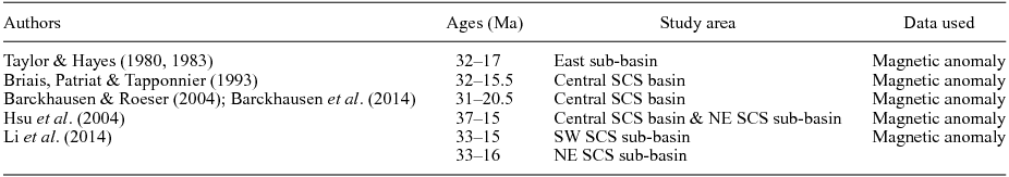
The tectonic development of the South China Sea is a highly debated issue (Barckhausen et al. Reference Barckhausen, Engels, Franke, Ladage and Pubellier2014, Reference Barckhausen, Engels, Franke, Ladage and Pubellier2015; Li et al. Reference Li, Xu, Lin, Sun, Zhu, Yao, Zhao, Liu, Kulhanek, Wang, Song, Zhao, Qiu, Guan, Zhou, Williams, Bao, Briais, Brown, Chen, Clift, Colwell, Dadd, Ding, Almeida, Huang, Hyun, Jiang, Koppers, Li, Liu, Liu, Nagai, Peleo-Alampay, Su, Tejada, Trinh, Yeh, Zhang, Zhang and Zhang2014; Chang et al. Reference Chang, Lee, Hsu and Liu2015). The duration of spreading, in particular, is one of a number of issues that has yet to be fully resolved (Table 5). Originally Taylor & Hayes (Reference Taylor, Hayes and Hayes1980, Reference Taylor, Hayes and Hayes1983) proposed a magnetic anomaly chronology for the South China Sea basin which is still widely accepted (11 to 5d, Taylor & Hayes, Reference Taylor, Hayes and Hayes1980, Reference Taylor, Hayes and Hayes1983; revised to 11 to 5c, Briais, Patriat & Tapponnier, Reference Briais, Patriat and Tapponnier1993). They identified an E–W-oriented spreading centre between the Macclesfield Bank and Reed Bank (Fig. 9), where the symmetric anomalies 5d through 6c have been modelled to the north and south. Beyond the Macclesfield Bank and close to South China were anomalies 7 to 11. The spreading ridge has a conjunction from a NW–SE direction to an E–W direction, and it is interpreted to be a result of a ridge jump that occurred at anomaly 7 (~24.8 Ma to 25 Ma) (Briais, Patriat & Tapponnier, Reference Briais, Patriat and Tapponnier1993; Barckhausen & Roeser, Reference Barckhausen, Roeser, Clift, Kuhnt, Wang and Hayes2004; Barckhausen et al. Reference Barckhausen, Engels, Franke, Ladage and Pubellier2014; Li et al. Reference Li, Xu, Lin, Sun, Zhu, Yao, Zhao, Liu, Kulhanek, Wang, Song, Zhao, Qiu, Guan, Zhou, Williams, Bao, Briais, Brown, Chen, Clift, Colwell, Dadd, Ding, Almeida, Huang, Hyun, Jiang, Koppers, Li, Liu, Liu, Nagai, Peleo-Alampay, Su, Tejada, Trinh, Yeh, Zhang, Zhang and Zhang2014).
Table 5. Age estimates of the South China Sea (SCS) basin from previous studies

The duration of tectonomagmatic activity of the South China Sea is generally accepted to be a ~16.5 million-year interval from 32 Ma to 15.5 Ma (Taylor & Hayes, Reference Taylor, Hayes and Hayes1980, Reference Taylor, Hayes and Hayes1983; Briais, Patriat & Tapponnier, Reference Briais, Patriat and Tapponnier1993); however, Barckhausen & Roeser (Reference Barckhausen, Roeser, Clift, Kuhnt, Wang and Hayes2004) suggested the South China Sea was active only for 11.5 Ma from 32 Ma to 20.5 Ma. Barckhausen et al. (Reference Barckhausen, Engels, Franke, Ladage and Pubellier2014) supported the short duration interpretation by proposing a new spreading rate for the South China Sea before and after the ridge jump, suggesting a 56 mm yr−1 rate in the early stages increasing to 72 mm yr−1 after the ridge jump in the central and NE sub-basin, and increasing to 80 mm yr−1 in the SW sub-basin. Li et al. (Reference Li, Xu, Lin, Sun, Zhu, Yao, Zhao, Liu, Kulhanek, Wang, Song, Zhao, Qiu, Guan, Zhou, Williams, Bao, Briais, Brown, Chen, Clift, Colwell, Dadd, Ding, Almeida, Huang, Hyun, Jiang, Koppers, Li, Liu, Liu, Nagai, Peleo-Alampay, Su, Tejada, Trinh, Yeh, Zhang, Zhang and Zhang2014) suggested that the age of spreading is 33 Ma to 15 Ma and that the ridge jump occurred at ~23.6 Ma, based on new deep-tow magnetic anomalies and an IODP Expedition 349 core. Li et al. (Reference Li, Xu, Lin, Sun, Zhu, Yao, Zhao, Liu, Kulhanek, Wang, Song, Zhao, Qiu, Guan, Zhou, Williams, Bao, Briais, Brown, Chen, Clift, Colwell, Dadd, Ding, Almeida, Huang, Hyun, Jiang, Koppers, Li, Liu, Liu, Nagai, Peleo-Alampay, Su, Tejada, Trinh, Yeh, Zhang, Zhang and Zhang2014) disagreed with the spreading rate proposed by Barckhausen et al. (Reference Barckhausen, Engels, Franke, Ladage and Pubellier2014) as they pointed out the spreading rate decreased from ~50 mm yr−1 to ~35 mm yr−1 during the later stages of spreading instead of increasing to 72 mm yr−1 after the ridge jump. Chang et al. (Reference Chang, Lee, Hsu and Liu2015) also commented that Barckhausen & Roeser (Reference Barckhausen, Roeser, Clift, Kuhnt, Wang and Hayes2004) and Barckhausen et al. (Reference Barckhausen, Engels, Franke, Ladage and Pubellier2014) had neglected the radioisotopic age of Jahn (Reference Jahn1986) and nanofossil assemblage from the ETO (Huang, Chen & Chi, Reference Huang, Chen and Chi1979) and advocated that the slow-spreading ridge is a more plausible model for the South China Sea.
If the ETO is a remnant of the South China Sea, the new age result in this study and by W. Y. Shao (unpub. Ph.D. thesis, National Taiwan Univ., 2015) suggests that magmatism and thus sea-floor spreading of the South China Sea lasted until middle Miocene time (i.e. ~14 Ma) and is ~1.5 million years younger than the accepted age. Jahn (Reference Jahn1986) suggested the ETO had a life span of < 10 Ma based on a spreading rate of ~10 cm yr−1 indicating that it travelled a maximum distance of 1000 km. However, the ~10 cm yr−1 rate may be too fast and the ~1000 km distance may be too large, but a rate of 5–8 cm yr−1 and maximum distance of 500 km to 800 km may be suitable (Ben-Avraham & Uyeda, Reference Ben-Avraham and Uyeda1973; Hall et al. Reference Hall, Ali, Anderson and Baker1995; Teng & Lin, Reference Teng, Lin, Malpas, Fletcher, Ali and Aitchison2004). From previous studies, the collision of the Luzon arc with the Eurasian continental margin occurred at ~4–5 Ma (Jahn, Reference Jahn1986; Teng, Reference Teng1987, Reference Teng1990, Reference Teng2007). Thus, the duration of the displacement of the ETO from the ridge to its current location would take ~10 million years (i.e. ~14.3 Ma to ~4.5 Ma). Based on a 5–8 cm yr−1 moving rate and 10 million-year duration, the possible displacement distance is between 500 km and 800 km, which are drawn as dashed circles in Figure 10. Figure 10 shows the estimated part of the South China Sea spreading ridge (dashed line) that was consumed beneath the Manila Trench and the orange zone is the general area of spreading and the likely original location of the ETO as it propagated eastwards (Lee & Lawver, Reference Lee and Lawver1995; Zhu et al. Reference Zhu, Wang, Chen, Chang, Hu and Xie2004).

Figure 10. Possible palaeographic reconstruction of the South China Sea and likely location of the ETO at ~15 Ma (revised from Lee & Lawver, Reference Lee and Lawver1995).
7. Conclusions
The new whole-rock major and trace elemental and isotopic geochemistry, mineral chemistry and zircon U–Pb age data presented here and from previous studies suggest that the ETO has characteristics that are typically found at spreading ridges of oceanic crust. The Cr no. of spinel and bulk-rock Al and Mg contents are consistent with the oceanic ridge setting. The depleted Nd isotopes of the gabbro and serpentinized peridotite and the N-MORB-like REE pattern of the ETO mafic rocks are consistent with a mid-ocean ridge environment. The middle Miocene zircon U–Pb age of the ETO gabbro is ~1.5 Ma younger than the last magnetic anomaly of the South China Sea (i.e. 5c) and suggests that magmatism and sea-floor spreading were still occurring. Moreover, the possible original location of the ETO is between 500 and 800 km south of Taiwan and within an area of ~100000 km2.
Acknowledgements
We thank Scott Whattam, an anonymous reviewer and Phil Leat for important editorial comments. We also thank George Ma, Yoshiyuki Iizuka, Kuo-Lung Wang, Typhoon Lee, Sun-Lin Chung and Yuan-Hsi Lee for their assistance with field and laboratory work. JGS thanks the Ministry of Science and Technology (Taiwan) for financial support through grant 102-2628-M-003-001-MY4.
Supplementary material
To view supplementary material for this article, please visit http://dx.doi.org/10.1017/S0016756816000054.