


Introduction
Longhouses became one of the most significant and iconic features of the Linear Pottery culture (LBK, c. 5500–4950 bc) introduced by the first farmers to Central Europe and beyond. At the height of its distribution, longhouse architecture could be found within a wide area ranging from the Paris Basin in the west to the Dnieper riverbanks in the east. Nevertheless, the essential elements remained unchanged: a quadrangular ground plan; emphasis on length; (main) entrance located in the gable wall; non-load-bearing construction of the side walls counterbalanced by a number of inner posts (beyond the demands of structural stability), which were spatially arranged in rows of three; and, last but not least, the longitudinal axis of house was deliberately set in specific cardinal direction (Coudart, Reference Coudart, Fowler, Harding and Hofmann2015: 320). Apart from these fundamental points, LBK architecture could be surprisingly variable, particularly in the later phases (here referred to as classic and late LBK), when the emergence of regional groups can be distinguished, especially in pottery decoration. Despite development escalating at the turn of the sixth and fifth millennia with the beginning of new, autonomous post-LBK cultural entities, the essential longhouse concept persisted, even if in a modified form. In this respect, only two attributes of the longhouse concept can be pronounced as truly independent of chronological and regional development: the elongated shape and deliberate orientation (Končelová & Květina, Reference Končelová and Květina2015: 438). These elements stress the indisputable emphasis that longhouse builders put on the positioning of their houses.
The origin and meaning of orientation have been addressed by many scholars, using various tools such as ethnographic parallels, statistical analyses, or ideological concepts. Conclusions essentially vary between environmental and cultural stances. With the support of comprehensive analyses, I would like to introduce to the discussion the position of the sun and light conditions.
Previous Approaches: Prevailing Winds and Land of Ancestors
Hand in hand with the increasing number of excavated complete longhouse ground plans in the early 1950s, the non-random alignment with cardinal directions (usually north-west–south-east) became apparent. Edward Sangmeister (Reference Sangmeister1951) offered a first explanation, supposing that the exposure of the rear part of the longhouse towards the prevailing winds in Central Europe was responsible for such an orientation. Despite no supporting arguments or data being presented, this opinion became widely accepted (e.g. Modderman, Reference Modderman1970; Startin, Reference Startin1978). Later, some traits of longhouse construction were interpreted with regard to the wind theory, such as the reinforcement of the rear section (Sielmann, Reference Sielmann and Schwabedissen1972: 6) and, in particular, the trapezoidal shape of post-LBK buildings, which would allow the buildings to resist unfavourable streaming (Soudský, Reference Soudský1969).
Based on ethnographic parallels from the New Guinea Highlands, where trapezoidal architecture is used, Marshall (Reference Marshall1981) argued that the Neolithic longhouse alignment can provide air circulation in the interior suitable for the removal of smoke. Orientation according to the prevailing winds is, therefore, motivated more by the microclimate of the building than by its stability. However, while the New Guinean trapezoidal houses are entered from the narrower gable wall, the archaeological evidence from Europe indicates the opposite mode, with the entrance at the wider end (Coudart, Reference Coudart1998: fig. 82). Moreover, as Marshall himself noted, there is a weak correlation between the declination of longhouses and current wind direction. This disagreement was explained by the long-term change in atmospheric circulation, which consequently made longhouses an important palaeoclimatic indicator (Marshall, Reference Marshall1981: 112–13). The vicious cycle of such argumentation is obvious. Even the ‘direction of prevailing winds’ appeared to be a variable that was hardly graspable. Individual scholars attributed this characteristic to the summer (Coudart, Reference Coudart1998: 88) as well as winter streaming (Hampel, Reference Hampel1989: 74). Even if Coudart found in her study that the rain-bringing winds from the sea coast could be a plausible factor in the orientation of trapezoidal houses (Coudart, Reference Coudart1998: fig. 102), it did not explain the total variation within the area of LBK and post-LBK longhouses.
To date, the most comprehensive and data-based contribution to this issue is the study by Mattheußer, which focused on the Merzbachtal in the western Rhineland as well as the wider LBK territory (Mattheußer, Reference Mattheußer1991). On the scale of regions and individual sites, continuity in the frame of Hofplatz unitsFootnote 1 was recognized. The replacement of houses over time seems to be a crucial factor. Indeed, if we consider orientation solely with respect to spatial proximity, no relationship becomes apparent, even though organizing settlements in rows has been suggested in a recent critique of the Hofplatz model (Rück, Reference Rück, Hoffmann and Bickle2009). At the macro-scale, the analysis was conducted in chronological periods referring to essential changes in Neolithic architecture during the early LBK (c. 5500–5300 bc) and developed LBK (c. 5300–4950 bc), with overlaps into the succeeding post-LBK period. The results show lower variability during the initial LBK period. Longhouse axes are oriented rather north-south, or with a slight western inclination in the western part of the early LBK area. This relatively homogeneous pattern disappeared with the spread of LBK after c. 5300 bc, when a correlation between house alignment and its location in terms of its longitudinal geographical position emerges. Even without statistical evaluation, there is obviously a strong inclination to align houses in a west–east direction in the western LBK regions. Nevertheless, not all sites fit this gradient, especially those with solitary buildings. The subsequent post-LBK period follows the previous trends only partially, as it is diversified by region, which corresponds to the general lack of architectural unity in this period. Three possible ways of interpreting the deliberate orientation of longhouses were presented by Mattheußer. Since the wind theory was rejected, and ritual or religious reasons are also not supported by the archaeological evidence (dissimilar orientation of houses and buried individuals), rules based on cultural habits were considered to be the most plausible. Increasing discrepancies within the orientation of longhouses, which appear at the same time as the general regionalization of material culture in the classic LBK and beyond, might be an indication. However, the role of environmental factors was not disregarded entirely, especially for the formative stages of the phenomenon.
Intentional longhouse orientation was also proposed by Bradley (Reference Bradley2001) as a principle deeply rooted in the occupants’ cultural identity. He noted that house axes respect the sequence and direction of the spread of the LBK. Houses might, therefore, face the land of the occupants’ ancestors, assuming that the (main) entrance to the house was through its southern, narrow wall. A bond with the ancestral land was maintained and expressed by exotic Spondylus shell artefacts and their distribution network, which is traceable from the Balkans to the European heartland, following the movement of the first farmers. Bradley's argument was taken up by Hauzeur (Reference Hauzeur, Guerci, Consigliere and Castagno2006), who noticed that longhouse orientation was not determined by the local topography of a settlement area, as documented by the intra-site spatial organization at Altwies-Op dem Boesch. Generally, we can support this statement with evidence from other sites situated on slope as the longhouses were set both uphill (Rück, Reference Rück, Hoffmann and Bickle2009: 173–75) and downhill (Květina & Pavlů, Reference Květina and Pavlů2007). Thus, Hauzeur (Reference Hauzeur, Guerci, Consigliere and Castagno2006) also considered orientation to be a cultural choice; and, following Bradley's hypothesis, she pointed to the alignment of houses on the western fringe of the LBK world as being oriented towards the Upper Danube, an area from which expansion westwards took place. However, not all sites fit this model (see Hauzeur, Reference Hauzeur, Guerci, Consigliere and Castagno2006: fig. 3).
Spatial Analysis of House Orientation
More than twenty-five years have passed since the last comprehensive analysis of longhouse orientations was undertaken (Coudart, Reference Coudart1998 is based on a study undertaken by her in 1987). Meanwhile, the number of excavated ground plans has increased enormously and revision based on current data is obviously required. The dataset created for this purpose comprises a total of 1546 longhouse ground plans (Figure 1; Supplementary tables 1–3), studied in three major chronological periods: the early LBK (n = 142), the classic and late LBK (n = 988), and the post-LBK (n = 416). The last period comprises regions and cultural groups where the concept of the longhouse persisted before it was replaced by new architecture. However, it is not only the quantity of analysed entities, but also their quality in terms of spatial distribution that is crucial for obtaining a truly representative dataset. Whereas there are a satisfactory number of excavated and published ground plans from the western regions, the eastern areas are much less well represented. For this reason, they have been omitted or underemphasized in previous analyses (see Mattheußer, Reference Mattheußer1991: fig. 22; Coudart, Reference Coudart1998: fig. 102). Current studies present evidence, albeit scanty, of LBK architecture in the east, even in Ukraine and Moldova (see Supplementary table 2: Durlești, Florești, Rovancì, and others), where the Central European longhouse construction type is assumed (Tringham, Reference Tringham1971: 135). Despite this, contrasts between western and eastern areas are still apparent, and it is, therefore, impossible to completely avoid a certain clustering of longhouses in regions with a strong tradition of LBK studies (Figure 2).

Figure 1. Sites employed in the spatial analysis. For site names see Supplementary materials.
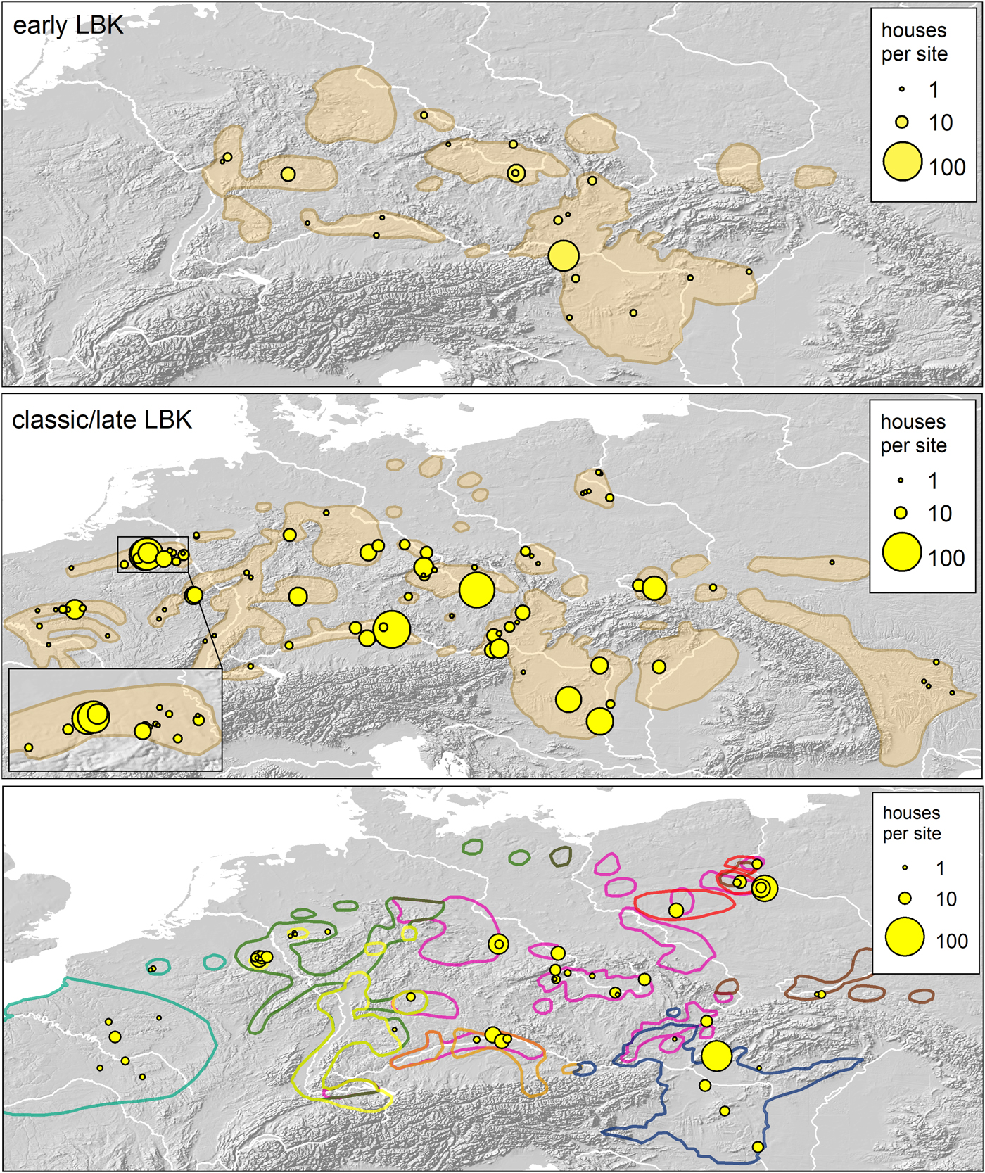
Figure 2. Spatial distribution of longhouses in the dataset. The current state of research results in an over-representation of certain regions.
To trace trends in longhouse alignment, the assembled data were interpolated by the kriging method. This is suitable for irregularly distributed inputs as analysed here and also reflects non-linear gradients, which can be expected (Conolly & Lake, Reference Conolly and Lake2006: 97–98). The analysed house azimuth (α) was defined as the deviation of the longitudinal axes of orientation of the houses from geographical north; positive values refer to western inclination, whereas negative values refer to eastern inclination. Specific trends, as well as the general trajectory, can be observed in all chronological periods (Figure 3). As previous studies have already noted, there is a lower variability during the initial LBK dispersal phase (Mattheußer, Reference Mattheußer1991: 25–27), when the north–south orientation is more or less respected in the core region comprising Transdanubia, Moravia, Lower Austria, Bohemia, Bavaria, and Saxony. A significant north–west orientation was recorded only on its margins; however, the north-eastern part of the Carpathian Basin, for instance, is represented just by the Alföld LBK site of Füzesabony-Gubakút. Despite an apparent conformity of orientation in the early LBK, expressed by a lower standard deviation, one should bear in mind that the overall diversity still reaches 100° (Table 1).
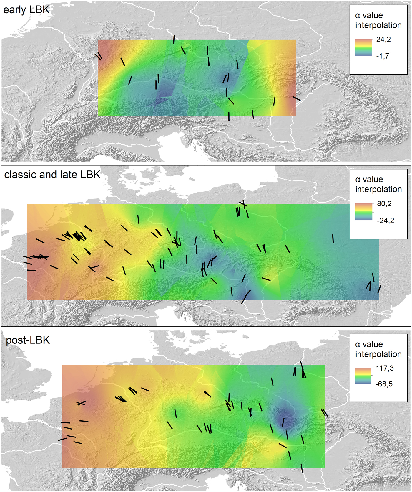
Figure 3. Interpolation of longhouse azimuths (α) in three chronological periods. Positive values refer to the western inclination of house axes and vice versa. Mean values of house orientation on individual sites are also shown.
Table 1. Value of house azimuths (α) in different chronological periods. *Some multi-phase sites include longhouses from more than one chronological period.

The core area also maintains conventional orientation later in the developed LBK period, but simultaneously we can observe an inclination towards a west–east axis in western areas, especially in the Paris Basin. As the area of longhouse distribution expanded, the variability also increased, reaching 167° in total (similar to Mattheußer's 153°). Despite there being no distinctive breaking point between the former core area of rather north–south oriented and the area of east–west inclination, we can loosely define the Upper Danube and Central Germany as zones of change. A slight inclination towards the west was registered in Poland too, but north-south or north-east to south-west orientations generally dominate in the east. An impression of a gradual trend across Europe is given by a significant correlation between the azimuths of houses and their longitudinal positions (r = −0.71; p < 0.01). However, this impression is affected by the overrepresentation of longhouses from western regions in the dataset. By contrast, in eastern areas (where only scanty evidence of excavated ground plans exists), the spread of longhouse construction did not give rise to any shifts in their orientation. There is also a substantial degree of variability when we move from the macro-scale to a detailed intra- and inter-regional focus (Oross, Reference Oross and Gheorghiu2010: 73; Einicke, Reference Einicke, Beier, Einicke and Biermann2011).
Surprisingly, patterns remain more or less the same in the post-LBK period, although general variability further increased to a total range of 189°. Whereas the early post-LBK period (early Stichbandkeramik culture or stroke-ornamented pottery culture, Grossgartach, or Villeneuve-Saint-Germain cultures) can be seen as a prolongation of previous trends, this was seriously challenged later, as evidenced in particular on sites of later Lengyel and Brzecz Kujawski cultures (see Supplementary table 3: Hulín-Pravčice 2, Miechowice 4, Racot, Žlkovce). Here, extreme north-west as well as north-east house alignments were recorded simultaneously, representing a new level of intra-site variability.
Addressing the Old Question with New Data
The theory that longhouse orientation reflected the inhabitants’ origin is not applicable to the whole area of LBK and post-LBK longhouses. Deliberate house orientation can already be observed in the formative region of Transdanubia prior to the widespread LBK expansion (Bánffy, Reference Bánffy, Hofmann and Smyth2013). Following Bradley's (Reference Bradley2001) arguments, prestige artefacts made of Spondylus shell can be employed to highlight the link between LBK farmers and the land of their ancestors, but what we observe is a rather problematic connection with the longhouse setting. While deliberate orientation is recorded everywhere, the distribution of Spondylus shells is very sparse in some regions (Bohemia, Belgium, Lesser Poland, Ukraine, and Moldova) when compared to a presumed occupation density (Chapman & Gaydarska, Reference Chapman, Gaydarska, Fowler, Harding and Hofmann2015: fig. 33.1). Moreover, obvious shared ideas about the correct direction to orient a longhouse persisted into the post-LBK period; even as the LBK unity was replaced by more localized groups, Spondylus artefacts disappeared (Chapman & Gaydarska, Reference Chapman, Gaydarska, Fowler, Harding and Hofmann2015: 645–48) and the initial LBK spread became a hundreds-of-years-old echo.
The ‘ancestral homeland’ (Bradley, Reference Bradley2001: 55) appears to be quite a loose entity. If we rely on the evidence of the Spondylus distribution network, all houses should be oriented towards the Balkans. This is, however, unsupported by real data. For example, Lower Bavaria was relatively well supplied in shells (Hofmann et al., Reference Hofmann, Pechtl, Bentley, Bickle, Fibiger, Grupe, Bickle and Whittle2013), but their origin is not reflected in the orientation of the houses. If the house entrance follows the ‘sequence and direction of LBK colonisation’ (Bradley, Reference Bradley2001: 53), then a general inclination to the south-west should be apparent at the eastern margins of the dispersal of longhouses. It is not. Furthermore, in particular regions or sites, significant discrepancies emerge. The entrances of Moravian houses faced south-west since the early LBK instead of following a south-east orientation, as would be expected. Sites on the southern bank of the Danube in Bavaria do not fit the model either, being oriented more towards the south than towards a presumed direction of diffusion (for more sites, see Pechtl, Reference Pechtl, Chytráček, Gruber, Michálek, Sandner and Schmotz2010: fig. 7). Considering major water courses as corridors of migration and transmission, the north–south orientation observed in this region appears surprisingly contradictory. It does not respect the north-west to south–east route of the river Danube at all.
Despite the doubts expressed here about Bradley's interpretation, his tracking of tracing of longhouse orientation via the front gable wall (instead of the commonly analysed opposite direction defined by the rear part of the house) seems to be more apposite. The presence of an entrance made this part of the longhouse undoubtedly significant for the houses’ occupants.Footnote 2 When the assemblage is analysed in this way, a prevailing south-east orientation is apparent, even if we see a tendency towards increasing heterogeneity over time (Figure 4). Although the analysis of Neolithic longhouse orientation is influenced by chronological as well as spatial variability and the over-representation of longhouses from specific regions, several patterns that are universally applicable throughout the LBK and post-LBK milieu can be inferred:
1) Orientation, though not strict, is deliberate across the whole distribution area of LBK and post-LBK cultures, indicating that it was apparently not owed to local conditions.

Figure 4. Orientation of longhouse entrances in three essential chronological periods.
2) Longhouse entrances were mostly oriented towards the south-east. South-westward or even eastward alignments also occurred, but orientations towards the north-east were extremely rare. No entrance faced significantly north or north-west, since the limits of 69° from south to west and 120° from south to east were not crossed.
3) Chronologically, there is evidence of increasing variability and dispersal over the course of time.
4) Geographically, an increasing western inclination can be found in western areas. However, fluctuation occurs even within individual regions and, in the post-LBK, also on individual sites. Orientation did not undergo significant changes during longhouse diffusion within the eastern areas.

Shadow Impact and Solar Radiation Analysis
The identification of a tendency to align houses towards the south, south-east, or south-west, which are the cardinal directions linked with the celestial path of the sun, leads us to consider a possible relationship between house orientation and the arc of the sun. To date, such an interpretation has been put forward only marginally in connection with Neolithic longhouses; it is usually mentioned as a conceivable, but implausible explanation, or as a theory not further expanded on (Mattheußer, Reference Mattheußer1991: 37; van de Velde, Reference van de Velde2007: 22–23; Bickle, Reference Bickle, Hofmann and Smyth2013: 163–64). The influence of celestial bodies on longhouse position was investigated more closely by Pásztor and Barna (Reference Pásztor, Barna and Ruggles2015), although their study focuses instead on Bronze Age dwellings, leaving the issue of Neolithic longhouses on a theoretical level.
The sun's position might be the unifying element on which the similar setting of buildings over the wide area occupied by Neolithic longhouses was based. It should, however, be emphasized that no strict or precise alignment indicating a kind of calendrical perception is assumed. Yet, especially in the initial stage of the LBK, the overwhelming majority of house azimuths (α) did not cross the limits set by the angular distance of the winter solstice sunrise and sunset points from the south (β).Footnote 3 As the winter solstice path defines the minimal seasonal trajectory, the longhouse's relation to the sun becomes clearer. Despite increased heterogeneity in the developed LBK and post-LBK, the vast majority of analysed houses still faced the winter solstice sun with their front gables (Figure 5). Using broader criteria, only six classic/late LBK and six post-LBK houses from the analysed assemblage crossed the limit of the equinox sunrise and sunset azimuth, that is the east–west orientation.
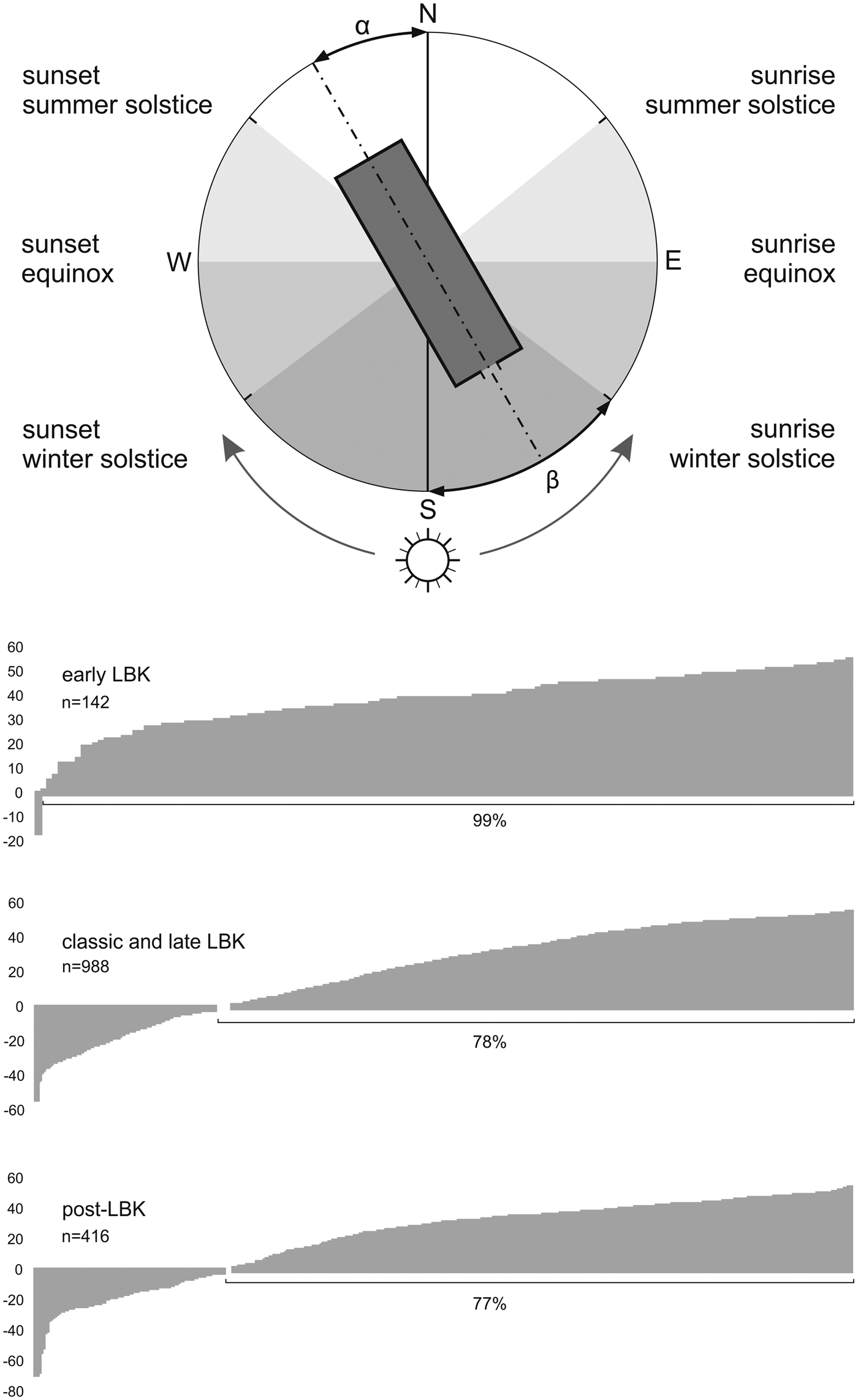
Figure 5. The concept of longhouse orientation towards the celestial path of the sun. The graphs show the conformity of longhouse orientation with the winter solstice trajectory of the sun expressed as β -|α|.
The deliberate alignment to the light-emitting sun undoubtedly influenced the seasonally and daily variable shadow cast by the house itself and might result in a specific relationship between illuminated and shaded areas on the building's facade. To test this assumption, a light-and-shadow model (McCluskey, Reference McCluskey and Ruggles2015a; Zotti, Reference Zotti and Ruggles2015), based on the 3D-reconstruction of two LBK longhouses, was created. Two houses were chosen as representative of two distinct categories of axis alignment: house no. 679 at Bylany, oriented north-north-east to south-south-west (Květina & Pavlů, Reference Květina and Pavlů2007), and house no. 380 at Cuiry-lès-Chaudardes with a strong west–east inclination (Ilett et al., Reference Ilett, Constantin, Coudart and Demoule1982). The form and constructional traits used for reconstruction are rather conventional (Table 2) and fit the generally accepted image of longhouses (Startin, Reference Startin1978; Coudart, Reference Coudart2013), although this is challenged by other plausible reconstructions of Neolithic longhouses comprising a raised floor (Rück, Reference Rück, Hoffmann and Bickle2009), a residential second storey (Czerniak, Reference Czerniak, Amkreutz, Haack, Hofmann and van Wijk2016: 47–53), additional side wall entrances (Meyer-Christian, Reference Meyer-Christian1976), or an open southern section (Stäuble, Reference Stäuble2005: 194). Nevertheless, accepting these alternatives would not significantly influence the resulting model.
Table 2. Parameters of 3D longhouse reconstruction and their approximate influence on the light-and-shadow model.

As both analysed houses vary significantly in their orientation—the most important aspect when reconstructing the light-and-shadow interplay—results are considerably different (Figures 6 and 7). The model of slightly eastward-declined Bylany house unsurprisingly reveals that the front gable wall was frequently lit by the sun. Lower sun declination between the two equinoxes, with the minimum at the winter solstice, causes nearly permanent illumination of the house entrance in the course of the day, which contrasts with the decreased direct impact on the roof. Nevertheless, the low rate of solar radiation and number of sunny days during winter must be considered. On the other hand, the summer solstice maximum, with higher solar declination, favours the sunray impact on the roof surface, even if the entrance is illuminated at least around the solar noon. Generally, a kind of duality in the Bylany model can be observed, since, during the morning and afternoon, the light is cast on only one half of the building, whereas the other half remains in shadow. Such an effect is also visible at the Cuiry-lès-Chaudardes house, although the pattern is slightly different, as there is nearly no interchange between the two sides. Except for during summer early mornings and late evenings, the northern side wall remains shaded and vice versa. Insolation of the entrance occurs during morning periods all year round, because the front gable faces east.
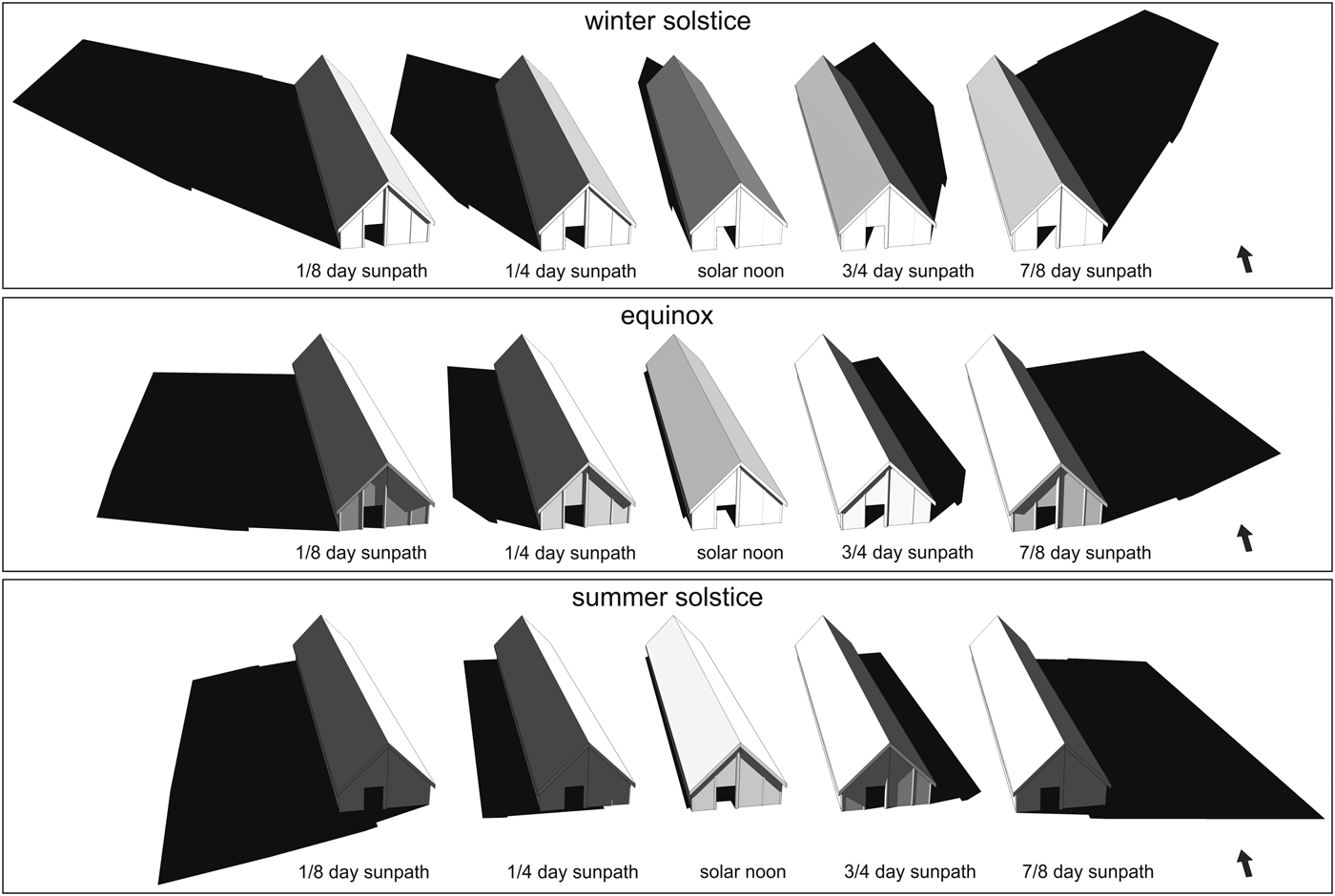
Figure 6. Light-and-shadow model of house no. 679 at Bylany.
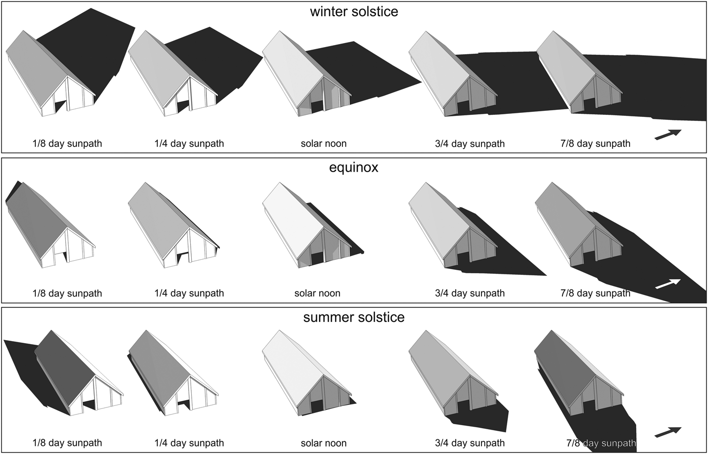
Figure 7. Light-and-shadow model of house no. 380 at Cuiry-lès-Chaudardes.
In addition to the houses themselves, their surroundings were also affected by the changing position of the sun. The specific light-and-shadow conditions in this area are testable by solar radiation analysis, which models the solar energy input all year round (Chow et al., Reference Chow, Fung and Li2014). The Bylany case shows a regular reduction of solar radiation in a buffer zone some 5 m wide along the side walls, where flanking borrow pits usually occur. At Cuiry-lès-Chaudardes, there is a significant unbalance along the longitudinal axis of the house as the southward-oriented side wall received a higher amount of solar energy (Figure 8). The analysis also revealed the contrast, observed earlier, between the front and rear gable walls. Even in the case of this extremely east–west deviated house, the area in front of the entrance and gable wall receives a relatively high portion of sunlight, especially in comparison to the rear wall and its surroundings, which is undoubtedly one of the less illuminated parts. The difference between the two areas can total a substantial 400 WH/m2 per year.
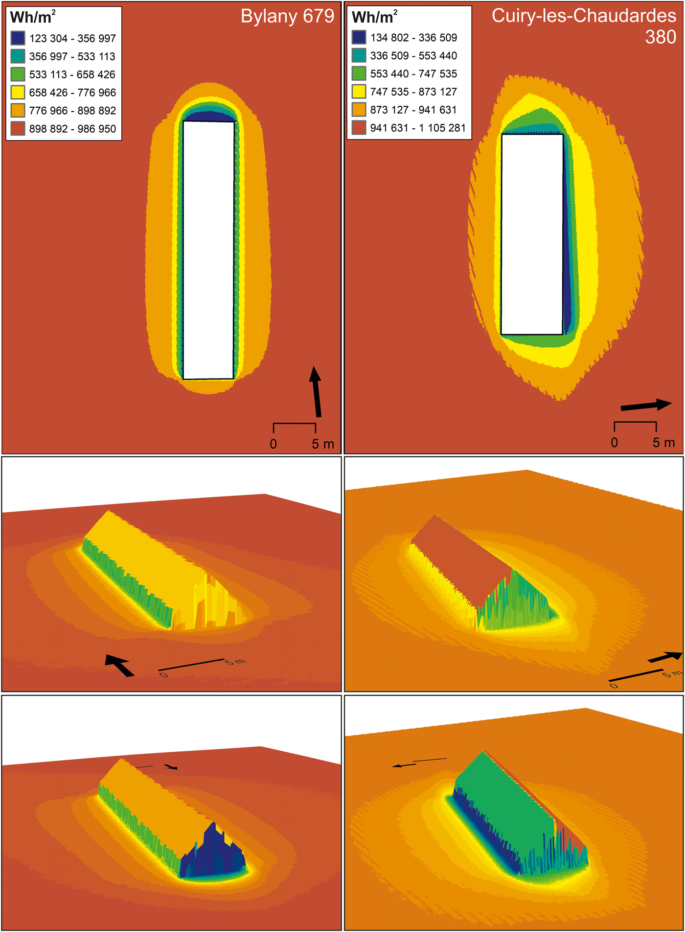
Figure 8. Year-long insolation rate of longhouses and their surroundings in plan and 3D views. Warm colours represent areas with a higher year-long sunshine impact. The calculation was performed for a generally clear sky (diffuse proportion 0.3; transmittivity 0.5).
These analyses were performed on houses representing two distinctive examples of alignment. The overall mean (23.2°) and the median (19°) for Neolithic longhouse orientation, which refers to the prevailing north-west to south-east declination, indicates that a considerable number of buildings can be considered as being halfway between. For such houses, one may expect the prevailing solar impact on the front wall to disadvantage the rear part of the house. The amount of solar energy impact would be substantially influenced in a 5-m-wide perimeter, giving a slight advantage to one side, which received more light. To reverse this pattern, the house orientation would have to be changed significantly, for example by making the entrance face northwards.
Discussion
To understand the motives leading to the unified orientation of longhouses, we should focus on the very beginnings of the longhouse tradition in Neolithic Europe. The construction of five longitudinal post rows accompanied by wattle-and-daub walls with flanking pits emerged in the mid-sixth millennium in the melting pot of northern Transdanubia, especially in the region of Lake Balaton (Bánffy & Oross, Reference Bánffy, Oross, Gronenborn and Petrasch2010). Except for the rare evidence from the Vinča culture, the identical setting of houses throughout the whole area of distribution is distinctively an LBK attribute (Bánffy, Reference Bánffy, Hofmann and Smyth2013). The solar alignment, or rather the southern orientation of the entrance, might have been an attempt by the occupants of the house to maximize the advantages of sunlight impact. According to some scholars, northern Transdanubia offered less favourable climatic conditions compared to the previously occupied ecozones in the Balkans, which contributed to the modification of previous traditions to the new material culture of early LBK communities (Bánffy, Reference Bánffy, Hofmann and Smyth2013: 138). However, in our approach, the roots of deliberate setting go beyond simple environmental determinism.
As the sun changes its celestial path on a cyclical basis, the trajectory and regularities are observable and graspable by ordinary observers, even without understanding the astronomical process that lies behind it. Nonetheless, conceptions of the sky cannot be seen as merely arbitrary or superficial impositions of culture on nature. Rather, they should be viewed as the result of the dynamic interaction between the sky and culture (Iwanizsewski, Reference Iwaniszewski and Ruggles2015: 319). Anthropological studies in non-Western societies provide several examples of a cosmological or mythological meaning accorded to longhouses consciously oriented towards the sun. For instance, the Iban longhouses in Borneo are built to be orbited by the sun during the day. Specific house parts are illuminated by sunrise and others by sunset. In Iban cosmology, the east is syllogistically associated with life, particularly its beginnings, and the west with death (Sather, Reference Sather and Fox2006: 80–81). In the archaeological record, sun-dependent orientation is argued for circular houses of the British Iron Age (Pope, Reference Pope, Haselgrove and Pope2007). Day-to-day life in prehistory had a ritual or symbolic character because cosmological principles were deeply embedded within the structure of habitual practice, but our interpretative framework should not reflect a simple dichotomy between ‘ritual’ and ‘secular’. These were not two different sides of a coin in the non-dualist mode of thought of pre-Enlightenment societies (Brück, Reference Brück1999: 319–25). The southern or south-east direction derived from the celestial trajectory of the sun obviously had a prominent position in the specific logic and cosmology of Neolithic longhouse inhabitants. The houses might have faced a ‘land of sun’, a place not necessarily linked with ancestors, given that no significant relationship between longhouse orientation and the position of their buried inhabitants has been recorded (Mattheußer, Reference Mattheußer1991: 37; Whittle, Reference Whittle, Hadjikoumis, Robinson and Viner2011). This ‘land of sun’ might not have necessarily been firmly embodied in the real world, but rather existing in the landscape of the imagination (Pechtl, Reference Pechtl2009: 416–17). Such a theory is in agreement with the observed variability and certain vagueness of longhouse alignment. Deliberate orientation was incorporated in the concept of the LBK longhouse since its very beginnings, which shows the longhouse to be a complex set of innovations going beyond the simple adaptation of previous architectural traditions.
Adequate space between contemporaneous buildings allowed each house to create its own uninfluenced pattern. In the case of buildings approximately set north–south or north-west to south-east, the front gable wall was exposed towards the sun for a major part of the day. The presence of the entrance together with the amount of insolation predetermined the front gable to be the focal point and daily illuminated scene of social interaction. Based on the later sporadic evidence of wall paintings at Libenice in Bohemia (Steklá, Reference Steklá1961: 86), and specific constructional traits (Pavlů, Reference Pavlů2000: 222), we can assume that the front wall manifested the identity and status of its occupants (Bickle, Reference Bickle, Hofmann and Smyth2013: 155). It played a significant role in the transition between private and public—shaded interior and sunlit exterior—creating not only a physical but also a symbolic boundary where social interaction with incomers could take place and where access for outsiders could be accepted or restricted (Rapoport, Reference Rapoport1982: 180–81; Parker Pearson & Richards, Reference Parker Pearson, Richards, Parker Pearson and Richards1997: 24–29). On the other hand, intra-community relations were strengthened by commensality or shared craft activities. Especially in the spring and summer months, the sunny gable wall might have been preferred to the dark interior, simply because there was a wide array of household craft activities to be performed, for example textile processing, pottery making, or hide working, which demanded a certain level of lighting (the presence of windows and, hence, their influence on interior light conditions in longhouses remains speculative). These activities produced only scant refuse or other material evidence in the vicinity of the location where they were undertaken; therefore, only with difficulty could they be traced in the archaeological record. However, even the simple spatial distribution of sunken features can be an important indicator. As Rück has noted (Reference Rück, Hoffmann and Bickle2009: 163–64), a feature-free area can be observed in front of LBK longhouses. Although the author sees this pattern as evidence of a raised terrace, we suggest that it represents a communication zone around the house entrance. After all, phosphate analyses conducted not only inside the houses but also between them are in agreement with this assumption, as the signals are low in front of the houses (Stäuble & Lüning, Reference Stäuble and Lüning1999).
By contrast, the rear gable wall and its vicinity received the lowest amount of sunlight and usually remained shaded during the day. This might have resulted in specific microclimatic conditions, for instance the higher moisture content of wooden components and their predisposition to decay, and influenced house construction. The surroundings of the rear sections of longhouses show higher phosphate values despite the absence of sunken features (Stäuble & Lüning, Reference Stäuble and Lüning1999); the analysis of preserved occupation layers at the site of Hanau-Klein-Auheim has also revealed that flint-working was carried out there (Wolfram, Reference Wolfram, Hamon, Allard and Ilett2013: 81). Thus, the northern surroundings of a house were probably designated as zones with a low frequency of movement, where waste, particularly dangerous debris (such as sharp knapped stones), could be deposited. The post-LBK development towards trapezoidal ground plans may have been (besides other plausible explanations) an attempt, on the one hand, to accentuate the southern wall which represented the occupants themselves and absorbed a higher amount of solar energy; and, on the other, to reduce proportions of the most shaded and vulnerable part of the building. As for the duality of the light-shadow conditions along the side walls, its effect remains disputable. The occupants of a house could profit from the disproportion in solar impact by moving between the two sides during the day. Here, we face a lack of in situ evidence of routine activities, because the infill of pits flanking the side walls is a rather unreliable source.Footnote 4
Despite the model outlined above, inter-regional variability is not negligible, especially in the western regions, and this casts doubt on the role the alignment of the sun may have played. First of all, we should consider the degree to which any specific house's deviation was perceived by individual LBK people. Investigating house orientation by using the tools of modern geometry and expressed in angular measurements may result in some differences being overemphasized. This can be illustrated by the discrepancies in longhouse ground plans recorded occasionally, where rear or front sections, probably representing additional extensions of the basic house form, do not fully respect the setting of the central section. Such a deviation can be as much as 6° (Coudart, Reference Coudart1998: 74; Rück, Reference Rück, Hoffmann and Bickle2009: 159–63). The eastern orientation of medieval Christian churches may be a suitable parallel to a certain degree, even though it belongs to a very different framework of belief. The reasons for this eastern alignment do not seem to be strictly ideologically anchored and explainable (see McCluskey, Reference McCluskey and Ruggles2015b: 1703–05); and considerable variations and deviations certainly occur (Gonzáles-García & Belmonte, Reference González-García and Belmonte2015; Allen, Reference Allen2016). Nevertheless, a more or less uniform orientation of churches is visible across the whole of medieval Chistendom.
Regardless of the preferred model for the longhouse diaspora, knowledge sharing was essential for moving the Neolithic frontier by acculturation of indigenous populations, as well as for the transmittal of the longhouse concept and its orientation from one generation of migrating farmers to the next. Erecting the longhouse, a timber framework based on a rectangular ground plan, involved numerous individual tasks, where essential geometric principles, planning, and imagination needed to be employed, resulting in an undoubtedly complex operational chain. The marking of the house's spatial position in relation to cardinal directions was one of these tasks. It is assumed that not only the future occupants of the house, but also members of allied or kinship groups were needed to participate in building a longhouse, given the high overall labour demands (Startin, Reference Startin1978; Coudart, Reference Coudart, Fowler, Harding and Hofmann2015). This created the opportunity for the transfer of know-how and the ability to repeat the operation in the future via a tightly supervised learning process and immediate personal experience (Gibson, Reference Gibson, Box and Gibson1999; Chapman & Gaydarska, Reference Chapman and Gaydarska2011). Apparently, there was only one way for the early longhouse builders to position a new building, that is with the entrance facing more or less the zenith. This suggests that early LBK society was orthodox, with only subtle deviance being tolerated (Sommer, Reference Sommer2001: 257), but the swift spread of the first farmers (Jakucs et al., Reference Jakucs, Bánffy, Oross, Voicsek, Bronk Ramsey and Dunbar2016) could also have played a role.
The later appearance of minor inter-regional diversity even in the area of the early LBK substrate should also be considered within the framework of the social learning process. A specific deviation was probably passed and maintained within limited regional networks, but did not challenge essential principles of sun alignment. By contrast, the gradual change that emerged after longhouse builders entered the Rhineland, and especially after they crossed the boundary formed by the Rhine, does not seem to be of the same nature, given the strength of the phenomenon. Yet, no analogical process appeared with the expansion of the LBK in the east; therefore, this change in orientation can still be considered a spatially limited pattern. Previously agreed symbols of orthodoxy apparently became the subject of negotiation during later phases (Sommer, Reference Sommer2001: 260). Based on the archaeological record, the theory of orientation towards ancestral lands cannot be excluded (but only on the western edge of the LBK milieu), and this may have been a consequence of interactions with indigenous foragers (Bickle, Reference Bickle, Hofmann and Smyth2013: 159). Be that as it may, the entrance of a west–east oriented house still faced the sun in a certain way, although there was a shift in favour of morning time. The rear gable wall received little sunlight, and the northern side wall was now the most shaded. As might be expected, traces of flint knapping and waste deposition were recorded around the rear and side walls of west–east situated longhouses at the sites of Jablines and Echilleuses (Hachem, Reference Hachem2000: 308–09).
Conclusions
The west–east inclination, which emerged during the spread of the LBK westwards, was newly discussed in this paper and contrasts with the stability visible during the expansion of the LBK in eastern regions. These patterns are both preceded by the north–south convention in the core area inhabited during earlier periods. Hence, significant contradictions disrupt the theory of house alignment towards ancestral lands and its applicability to the whole extent and timespan of Neolithic longhouse architecture. Here, a new hypothesis for longhouse orientation has been proposed, and it concerns the role of celestial perceptions in Neolithic societies. Since it was observed that the predominant setting of house entrances was towards the south and the south-east, their relationship to the daily and seasonal path of the sun must be emphasized. This concept reflects the uniformity of orientation recorded already in the inception of longhouse architecture and is believed to be an integral element of what is called the LBK culture.
The 3D modelling has revealed specific patterns of light-and-shadow interaction, maximizing light around the entrance of the house. In a syncretic interpretational framework, where ritual and secular are not separated, the Neolithic longhouse can be perceived as a cosmological symbol, implemented in the daily routine of its occupants. Insolation of the front gable wall played an important role for carrying out household activities as well as for emphasizing the identity of the house community. Light conditions could meaningfully form the interior/exterior dualism both for a house's occupants and for outsiders. On the other hand, the vicinity of the rear end of the house, with less sunlight, seems to be marginal and used as a waste zone.
Uniformity and orthodoxy in orientation were challenged with the spread of the longhouse phenomenon towards the west, where houses nearly always have a west–east orientation. If we consider this change within the framework of sunlight alignment, the entrance remains illuminated at least in the morning. Thus, shift rather than change is a more appropriate term here, as it expresses a kind of adaptation rather than the overturning of initial principles. On the other hand, the gradual alteration of inclination may support the hypothesis of preferential orientation towards ancestral lands. Thus, along the western edge of the spread of longhouses, the two theories could be complementary.
Supplementary Material
To view supplementary material for this article, please visit https://doi.org/10.1017/eaa.2018.11.
Acknowledgements
I would like to express my sincere gratitude to Professor John Chapman for his helpful comments on this article, as well as for inspirational discussions during my visit to Durham University. I am also grateful to the anonymous reviewers who significantly helped to improve the final version of the manuscript. This work was supported by the Grant Agency of the University of South Bohemia under Grant GAJU 145/2016 H.


